bulloch county departmental reviewbullochcounty.net/wp-content/uploads/2011/09/baird-and-dye... ·...
TRANSCRIPT
Bulloch County Departmental Review
Applicant: Baird and Dye Properties, Inc. Application #: CS2008-083
Location: Burkhalter Road Application Type: Conceptual Site Plan
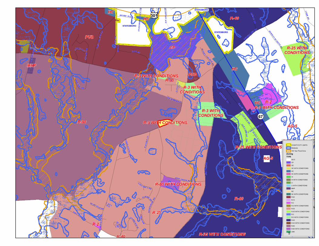
Map #: 093 000004 000 Current Zoning: R-3
Directions to Property:
Take Hwy 67 to Burkhalter Road. Turn right at light, turn right onto Langston Chapel Road, turn left onto Burkhalter Road. Property will be on the right across from second entrance to Burkhalter Plantation.
Request: Baird and Dye Properties, Inc. submitted a conceptual site plan to develop multi-family dwellings located on Burkhalter Road. The property is consists of 7.50 acres. Mr. John Dotson is action as agent.
LAND USE PLANNING IMPACT Future Land Use Map: The Bulloch County Joint Comprehensive Plan indicates that the property would be appropriate for residential development. Existing Land Use Pattern: There are primarily residential and agricultural uses at adjacent and nearby properties. Zoning Patterns and Consistency: The proposed change appears to be consistent with the zoning patterns in the nearby area. Neighborhood Character: There is evidence that the proposed change in use should not injure or detract from existing neighborhoods. Property Values: for adjacent properties may be enhanced by the proposed development provided aesthetics restrictions are placed in private deed covenants, and, if enforcement of County land use and property maintenance regulations is applied. However, failure to enforce any property standards is likely result in stagnant or lower property values. WATER / SEWER IMPACT All properties are subject to on-site septic tank installation and a community water system approval as required by the County Health Department. Soil types and proposed lot sizes are compatible and adequate for septic tank installation. SOLID WASTE IMPACT None expected. ENVIRONMENTAL IMPACT No impact is expected. FIRE SERVICE Fire service is available within 2.2 miles (response time 3 minutes) from the Statesboro Fire Department. No additional resources are required. TRAFFIC IMPACT The capacity and general condition of the roads accessing the proposed development is fair. Burkhalter Road is a county maintained paved road.
1
Bulloch County Departmental Review SCHOOL IMPACT Minimal impact is expected on existing schools. PARKING, ROAD AND DRAINAGE IMPACT The sketch plan in consideration of the scale of the development may possible create a significant traffic impact. Currently, all drainage is natural with no known man-made improvements to the existing development other than roadside drainage ditches and culverts. The accessways/driveways to the site should have proper roadside drainage measures. E-911 AND EMERGENCY MANAGEMENT IMPACT Street addresses can be easily assigned. The County Emergency Management Director should be contacted prior to construction. LAW ENFORCEMENT IMPACT Response time from Bulloch County Sheriff’s Department is approximately 9 minutes. However, depending on patrolling patterns and the location of deputies at a given time, this response may be greater or lesser. FINAL STAFF RECOMMENDATION The subject property appears suitable for the proposed development. The staff recommends approval of the conceptual site plan. Staff Reminder Conditions from Rezone 1) An additional 10% bonus density may be granted, provided at least one of the following
amenities shall be installed by the applicant: a) A pedestrian sidewalk system within the development. b) An internal streetscape consisting of native, non-ornamental canopy trees (maple,
dogwood, oak, etc.) with a minimum 4" caliper spaced 75' off center. The streetscape may optionally be integrated with amenities a) or c).
b) A county maintained street light district. c) A common interest element maintained by a homeowners association or other conduit
which may include, but not be limited to, a clubhouse, pool, tennis court(s), improved picnic area or playground, walking trail, or any combination thereof.
d) A common interest element maintained by a homeowners association or other conduit which may include, but not be limited to, a passive use recreation area (fishing, boating/dock, picnicking, etc.), conservation easement or greenspace area that is consistent with the goals and objectives of county or state land conservation or preservation plans and programs.
2) An Access Evaluation shall be performed. The scope of the evaluation shall concentrate on the subject property and the adjacent properties including properties across the road, and access issues within the immediate area of the proposed site. The requirements of the evaluation are for the most part required as part of the development review. The access evaluation shall include the following elements: a) Identification of building size and use, driveways, parking areas, and drive aisles.
2
Bulloch County Departmental Review
b) Identification of road details including right-of-way width, both existing and proposed, pavement widths, identification of vehicular lanes, and adjacent traffic control devices including stop signs and traffic signals.
c) Identification of adjacent access locations including properties across the road. d) A formal request to the county for review of the access. This can be conducted with a
site plan submittal or plat as part of the current staff development review process. The results of the access evaluation may be subject to either the Bulloch County Roads, Highways and Bridges Administrative Policies, the County Land Subdivision Regulations or the GDOT Driveway and Encroachment Control Manual at the discretion of the County Engineer. In the case of any conflict between the regulations, the more restrictive will generally apply.
3) All dwelling units must consist of traditional site built housing meeting state construction codes and have architecturally compatible brick, brick veneer facades, or hardyplank (except for trim).
4) All driveway entrances shall have landscaped islands. 5) To minimize the impact on contiguous property, the developer shall install a solid opaque
fence or a landscape buffer along the length of the western and northern boundary of the property with an average minimum height of six (6) feet at installation. This can be accomplished by: a) installing a landscaped berm and/or evergreen hedge combination; or, b) installing non-ornamental canopy trees (maple, dogwood, oak, etc.) with a minimum 4" caliper spaced 75' off center with evergreen hedges capable of growing up to 30" at maturity. The buffer shall be approved by the Zoning Administrator.
6) The proposed internal roadway shall be privately maintained. 7) A physical separation for the front setback area or streetscape along the right-of-way shall
be installed in the form of either: a) a “knee wall” with a minimum 36 inch height, constructed of either: concrete, stone, split-
faced masonry or other similar material; or pillars with wrought iron or similar material between the pillars;
b) a grassed berm with landscaped hedge (or combination thereof) of equal height may also satisfy the separation requirement.
The separator or streetscape shall be approved by the zoning administrator. 8) All well structures shall have a visual landscape or wall/fence buffer equal to the height of
the roof line.
Participants Tom Couch, County Manager; Andy Welch, County Planner; and Kirk Tatum, County Engineer; Randy Newman, Zoning Administrator.
3
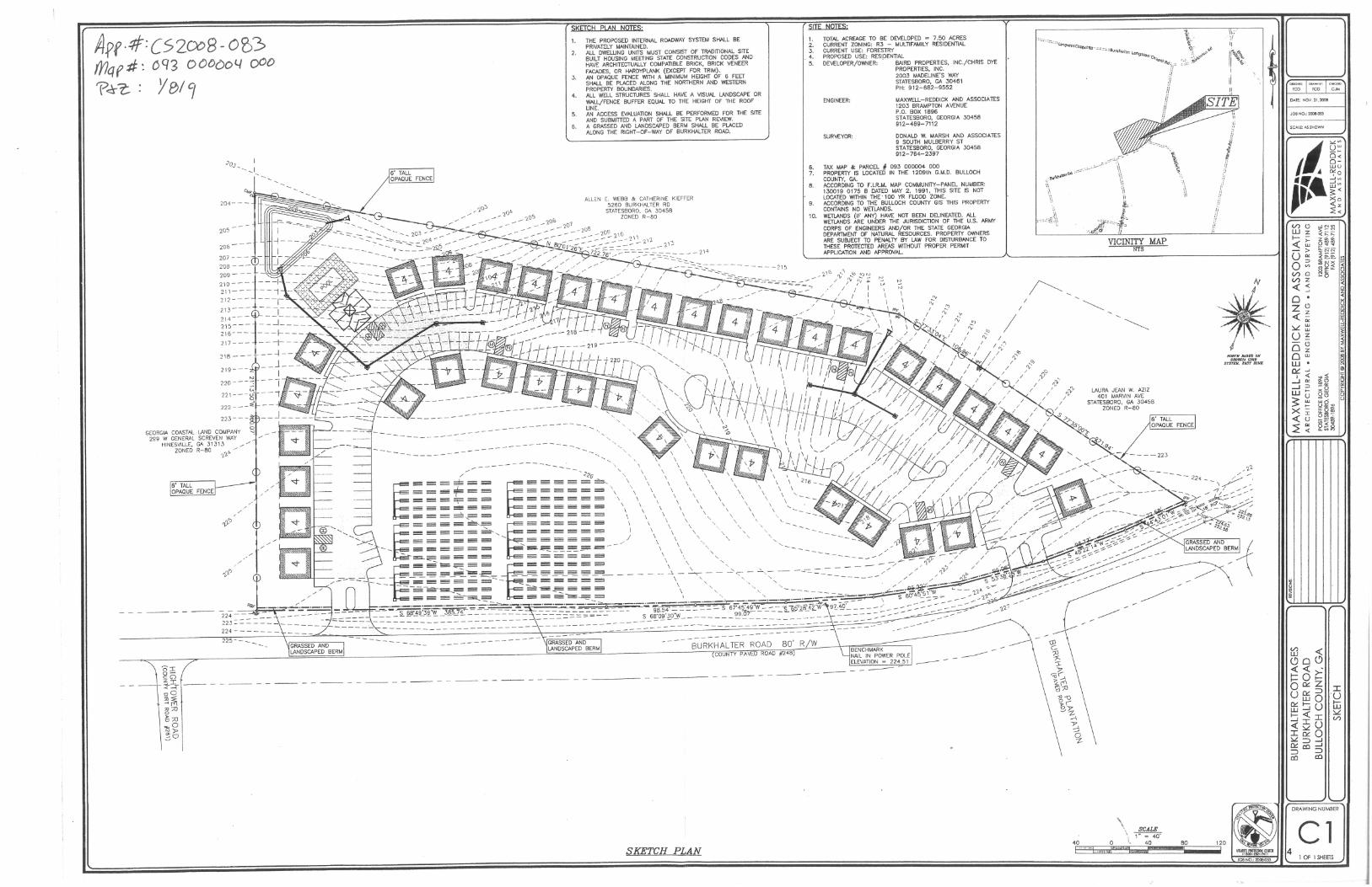
A.pf·#: C52ex>8 -O~3> fYlq f :tJ: 6 q 3 0 0000 l/ ()OO
'P~t: Y811
20'>
GEORGIA COASTAL LAND COMPANY 299 W GENERAL SCREVEN WAY
HINESVILLE. GA .3 131.3
ZONED R-80 7'"
225 - - __
- --- -- --- -------------
SKETCH PLAN NOTES'
1. THE PROPOSED INTERNAL ROADWAY SYSTEM SHALL BE PRIVAT[LY MAINTAINED.
2. ALL DWELLING UNITS MUST CONSIST OF TRADITIONAL SrTE BUILT HOUSING MEETING STATE CONSTRUCTlON CODES AND HAVE ARCHrTECTUALLY COMPATIBLE BRICK, eRICK VENEER FACADES, OR HARDYPLANK (EXCEPT FOR TRIM).
3. AN OPAQUE FENCE WITH A MINIMUM HEIGHT OF 6 FEET SHALL BE PLACED ALONG THE NORTHERN AND WESTERN PROPERTY BOUNDARIES.
4. ALL WELL STRUCTURES SHALL HAVE A VISUAL LANDSCAPE OR WALL/FENCE BUFFER EQUAL TO THE HEIGHT OF THE ROOF UNE.
5. AN ACCESS EVALUATlON SHALL BE PERFORMED FOR THE SrTE AND SUBMrTTED A PART OF THE SerE PLAN REVIEW.
6. A GRASSED AND LANDSCAPED BERM SHALL BE PLACED ALONG THE RIGHT-OF-WAY OF BURKHALTER ROAD.
ALLEN E. WEBB & CATHERINE KIEFFER 5260 BURKHALTER RD
STATESBORO. GA 30458 ZONED R-80
SITE NOTES'
1. 2. 3.
. 4. 5.
6. 7.
8.
9.
TOTAL ACREAGE TO BE DEVELOPED = 7.50 ACRES CURRENT ZONING: R3 - MULTIFAMILY RESIDENTIAL CURRENT USE: FORESTRY PROPOSED USE: RESI,DENTlAL DEVELOPER/OWNER: BAIRD PROPERTIES, INC'/CHRIS DYE
PROPERTlES, INC.
ENGINEER:
SURVEYOR:
2D03 MADELINE'S WAY STATESBORO, GA 3D461 PH: 912-682-9552
MAXWELL-REDDICK AND ASSOCIATES 1203 BRAMPTON AVENUE P.O. BOX 1896 STATESBORO, GEORGIA 30458 912-489-7112
DONALD W. MARSH ANO ASSOCIATES 9 SOUTH MULBERRY ST STATESBORO, GEORGIA 30458 912-764-2397
TAX MAP & PARCEL H 093 000004 000 PROPERTY IS LOCATED IN THE 1209th G.M.D. BULLOCH COUNTY, GA. ACCORDING TO F.I.R.M. MAP COMMUNrTY-PANEL NUMBER: 130019 0175 B DATED MAY 2, 1991, THIS SITE IS NOT LOCATED WITHIN THE' 100 YR FLOOD ZONE. ACCORDING TO THE BULLOCH COUNTY GIS THIS PROPERTY CONTftJNS NO WETLANDS.
10. WETLANDS (IF ANY) HAVE NOT BEEN DELINEATED. ALL WETLANDS ARE UNDER THE JURISDICTION OF THE U.S. ARMY CORPS OF ENGINEERS AND/OR THE STATE GEORGIA DEPARTMENT OF NATURAL RESOURCES. PROPERTY OWNERS ARE SUBJECT TO PENALTY BY LAW FOR DISTURBANCE TO THESE PROTECTED AREAS WITHOUT PROPER PERMIT APPLICATION AND APPROVAL.
----------------------
BURKHALTER ROAD 80' R/W COUNTY PA VED ROAD #248)
--------- - ----- - - -----
BENCHMARK NAIL IN POWER POLE ELEVATION = 224.51 --- -----
----- - - ----- - - ----- - - ----- - - ----- ---- - - -- ----- - -- -------
SKETCH PLAN
,! I>\I,~loItQl\\\\ '
~'. ;\ .~\
VICINITY MAP NTS
LAURA JEAN W. AZIZ 401 MARVIN AVE
STATESBORO. GA 30458 ZONED R-80
-- --223
NORTH BASED ON (;EORCIA GRID
SYSTEM, 8AST UlNK.
GRASSED AND ~ LANDSCAPED B~RM
~
JOB NO.: 2CO>-0S3
SCAlf: AS SHOWN
(/)0 Wz
~~ >
U'" 0'" (/)0 (/)z «< o· Z0 «~ ~~ U z
O~ o W·
'7;: -I '" -I'" Wu 3: ><I «u ~~
DRAWING NUMBER
Cl I OF 1 SHEETS
4
R-80 WITH CONDITIONS
R-80
R-80
R-40
R-40
R-40
R-40
R-3 WITH CONDITIONS
R-3 WITHCONDITIONS
R-3 WITH CONDITIONS
R-3 WITH CONDITIONS
R-3 WITHCONDITIONS
R-25 WITH CONDITIONS
R-25 WITH CONDITIONS
R-25 WITHCONDITIONS
R-25
R-2
R-2
PUD
PUD
MHP
HCHC
HC
HC
HC
CP
AG-5
AG-5
STATESBORO
STATESBORO
STATESBORO
301
67
STA T
ESBO
RO PL
A CE C
IR
B RA MPTO N
AV E
BOARD WALK
LAN I
ER D R
BIRD RD
BURK H
A LTE
R RD
CAYLA WAY
BIR D
LN
HARV
I LLE
RD
KERMIT DR
LANC
ELOT
CT
BUCKHEAD CT
CARRINGTON DR
BURKHALTER RD
OLD CARRAGE
TRL
SOUTH WYNN RD
MUIRFIELD DR
EXCALIBUR CT
HOLLOWAY LN
HUCKNALL PL
COBB RD
MANSFIELD RD
REBEKAH RD
BETHEL CHURCH RD
CAWANA RD
ELMER PHILLIPS RD
BELLA TERRA RD
JOSH SMITH RD
HERMAN RUSHING RD
FRANCES LN
OLD
REGI
STER
RD
JOHN
PROC
T OR R
D
SEA BORN
PROCTOR
RD
GOLF CLUB RD
COLUMBUS DR
VILL
AGE
DR
SOUTHBEND DR
WAVE
RLY L
N
JORDON DR
ASHLEY LN
BURKHALTER CIR
ST. ANDREWS CIR
H IGH
TOWER
RD
MEADOW
LAKESCT
COUNTY/CITY LIMITSWetlands100 Year Flood Zone
ZoningTYPE
AG-5CPGCGC WITH CONDITIONSHCHC WITH CONDITIONSHIHI WITH CONDITIONSLILI WITH CONDITIONSMHPNCNC WITH CONDITIONSPUDR-15R-2R-2 WITH CONDITIONSR-25R-25 WITH CONDITIONSR-3R-3 WITH CONDITIONSR-40R-40 WITH CONDITIONSR-80R-80 WITH CONDITIONSUNK5

Bulloch County Departmental Review Planning Commission – Approved Minutes (1/8/9) Presentation / Discussion Motion To approve the request Motion Wade Hodges Second Ann Henderson Vote Unanimous Opposed
6