buried valley of susquehanna river in luzerne county, pennsylvania
TRANSCRIPT

Buried Valley of Susquehanna River in Luzerne County, PennsylvaniaAuthor(s): N. H. DartonSource: The Journal of Geology, Vol. 21, No. 6 (Sep. - Oct., 1913), pp. 557-563Published by: The University of Chicago PressStable URL: http://www.jstor.org/stable/30058609 .
Accessed: 15/05/2014 17:15
Your use of the JSTOR archive indicates your acceptance of the Terms & Conditions of Use, available at .http://www.jstor.org/page/info/about/policies/terms.jsp
.JSTOR is a not-for-profit service that helps scholars, researchers, and students discover, use, and build upon a wide range ofcontent in a trusted digital archive. We use information technology and tools to increase productivity and facilitate new formsof scholarship. For more information about JSTOR, please contact [email protected].
.
The University of Chicago Press is collaborating with JSTOR to digitize, preserve and extend access to TheJournal of Geology.
http://www.jstor.org
This content downloaded from 195.78.109.122 on Thu, 15 May 2014 17:15:36 PMAll use subject to JSTOR Terms and Conditions
BURIED VALLEY OF SUSQUEHANNA RIVER IN LUZERNE COUNTY, PENNSYLVANIA
N. H. DARTON Bureau of Mines, Washington, District of Columbia
The broad river flats of the Wyoming Valley near Pittston, Wilkes-Barre, and Nanticoke, Pa., are underlain by a deposit of gravel, sand, and day which is more than 300 feet thick in places. This material occupies a channel which was excavated in the coal measures during early Quaternary time and it is a product of river deposition. Attention was first attracted to this feature many years ago when some of the coal workings reached sand which flowed into the mines in large volume and caused great loss of life.
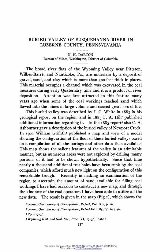
This buried valley was described by I. C. White in 1883 in his geological report on the region' and in 1885 F. A. Hill2 published additional information regarding it. In the 1885 report3 also C. A. Ashburner gave a description of the buried valley of Newport Creek. In 1901 William Griffith4 published a map and view of a model showing the configuration of the floor of these buried valleys based on a compilation of all the borings and other data then available. This map shows the salient features of the valley in an admirable manner, but as numerous areas were not explored by drilling, many portions of it had to be shown hypothetically. Since that time nearly a thousand additional test holes have been sunk by the coal companies, which afford much new light on the configuration of this remarkable trough. Recently in making an examination of the region to ascertain the amount of sand available for filling coal workings I have had occasion to construct a new map, and through the kindness of the coal operators I have been able to utilize all the new data. The result is given in the map (Fig i), which shows the
' Second Geol. Survey of Pennsylvania, Report, Vol. G 7, p. 26.
'Second Geol. Survey of.Pennsylvania, Report for i885, pp. 637-46. 3 Pp. 627-36.
4 Wyoming Hist. and Geol. Soc., Proc., VI, 27-36, Plate i.
557
This content downloaded from 195.78.109.122 on Thu, 15 May 2014 17:15:36 PMAll use subject to JSTOR Terms and Conditions

N. H. DARTON
salient underground relations excepting in certain relatively small areas, and also shows some minor features, although of course details can be ascertained only where the bore holes are closely placed. The configuration is represented by 50o-foot contours with sea-level datum. Where the data are not complete broken lines are used, and in such places the actual contour may differ more or less from that shown. The location of the more significant borings is indicated by dots in order to show the relation of the evidence on which the representation of contour is based. To show all the bore holes would make the map too complex and for this reason also only some of the larger surface features such as river and towns are given.
Glacial features of the region.-The Wyoming Valley region lies well within the area covered by the continental ice sheet of the Glacial epoch. There is a general mantle of till interrupted only by scattered rocky ledges, and the latter show glacial rounding and striation. The striae on the mountains bear to the south but some of those on the lower lands trend to the southwestward, indicating deflection of ice movement down the valley. When the ice was thick this deflection affected only its lower part, but in the earlier and later stages the main flow was greatly influenced by the local topography. This fact was recognized by H. D. Rogers in his later publications on conditions in the region.
The till consists of the usual materials, including many rock * masses from the north, and it is predominantly sandy. Some por-
tions are a heterogeneous mixture of sand and clay of bluish tint, carrying many bowlders. It appears extensively along the lower mountain slopes and varies in thickness from ioo feet or more to a very thin veneer and locally it is represented only by scattered bowlders and blocks. In slopes east of Miners Mills and again at a point a half-mile northeast of Alden it presents morainal features with low knolls and pits. Rearranged drift abounds, mostly con- stituting kame terraces along the sides of the valley. Evidently these were formed when the main valley was partly filled with a lobe of the retreating ice sheet.
Configuration of the buried valley.-The principal features of the buried valley of the Susquehanna are shown on the map (Fig. i), but there are some characteristics of special interest. It will be noted
558
This content downloaded from 195.78.109.122 on Thu, 15 May 2014 17:15:36 PMAll use subject to JSTOR Terms and Conditions

BURIED VALLEY OF SUSQUEHANNA RIVER 559
Nb
;V
-
EIPLI.ATION
u."SSOi'.
--
b Sxk.(
Det
sor"
bw
O
bo r
iSuquhnar
River
SCALE
Lrk'-- mc
rm,y .
K K
WYarI
L R L-" t
tcm
N
Lumm
KKingston
W W
300
Coal eauo"
20
200 FIG.
i.-Map
showing
configuration
of buried
valley
of Susquehanna
River
in Luzerne
County,
Pa.,
and
section
along
its deepest
portion.
By
N.
H.
Darton.
This content downloaded from 195.78.109.122 on Thu, 15 May 2014 17:15:36 PMAll use subject to JSTOR Terms and Conditions

N. H. DARTON
that the underground topography is very uneven and probably if all the details were brought to light much more irregularity of form would be seen. There are long basins and troughs, separated by irregular ridges and saddles, and numerous promontories project from the foot of the adjoining mountain slopes. The rocks are sandstones and shales of the coal measures and of course the excava- tion was effected by erosion prior to the filling of the valley. As shown on the map and section, the declivity of the underground valley is not like that of the present uniform river grade but there is a succession of irregular troughs. The deepest basin is near Ply- mouth from which to the southwestward there is a gradual rise of the rock floor as shown by many bore holes across the valley. Recent bore holes on the flats just east of Nanticoke show also that the rock comes to within less than 1oo feet of the surface on the south side of the present stream, and as the rock outcrops on the north bank not far away from this group of holes there is no likelihood of a deep channel in the interval. Possibly it may be suggested that there is a narrow canyon cut moderately deep in the rocks here, but a feature of that sort would not be accordant with the topography of the buried channel farther upstream. As noted by previous observers, rock ledges cross the valley at no great distance downstream. The suggestion that some of the deeper basins in the valley are "potholes" is not tenable, for they are too greatly elongated to be in that category.
Materials in the old channel.-The buried channel of the Susque- hanna is filled to the level of the present wide valley bottom with gravel, sand, and clay, which, as stated above, reaches a thickness of 309 feet at one place. In general the deposit varies from ioo to 200 feet thick in the greater part of the area. Sand predominates but there is a large amount of silt, or mixed clay and sand, and admixture of gravel in various forms. Some of the gravel is in beds of considerable thickness and extent, but it is generally mixed with much sand. There are many beds of clay intercalated in the deposits, one of them underlying Kingston attaining a thickness of more than 100 feet and extending for some distance up and down the valley. No definite order of strata for any wide area could be determined from the bore-hole records and apparently there is great
500
This content downloaded from 195.78.109.122 on Thu, 15 May 2014 17:15:36 PMAll use subject to JSTOR Terms and Conditions

BURIED VALLEY OF SUSQUEHANNA RIVER
variation in the succession from place to place, finer sediments merging into coarser ones in a very irregular manner. There may be considerable till or glacial drift in the valley but it could not be recognized in bore-hole records. Apparently most of the materials have been deposited by the river in part by swift currents and in part in slack water under conditions not very different from present ones at time of freshet when the flats are widely flooded.
The buried channel of Newport Creek.-The deep, narrow, sand- filled basin or trough under Newport Creek valley was described and discussed by Ashburner in i885 and its configuration was shown by Griffith in i909."
Later borings by the Susquehanna Coal Company have added some very important facts especially as to conditions north of shaft No. 2, where it is found that there is a rapid rise of the floor of the old valley instead of a continuous downgrade as previously sup- posed. Some of these data are shown in the map (Fig. i). This valley differs from that of the Susquehanna in containing a relatively wide area of high terrace deposits rising high above the creek.
The deposit in this valley is more than 250 feet thick in places, with its base nearly o50 feet below the bed of the creek and its top constituting a high terrace which originally occupied the entire valley. The greatest width is nearly one-half mile at a point about a half-mile above Nanticoke. Near shaft No. 2 in the northern part of Nanticoke the width of deposit remaining in the valley is only I,6oo feet and the bottom of the buried valley is only 82 feet below the creek bed. The thickness of deposits also diminishes to the southwest but they extend up the valley to beyond Glen Lyon. They thicken locally near this place, for at the Catholic church the depth to bedrock is 109 feet. The material in Newport Creek valley is largely sand with scattered gravel deposits and bowlders, but some portions are so fine grained as to be classed as quicksand.
Mill Creek buried valley.-For much of its course Mill Creek flows in a wide valley that finally merges into the river terrace on which most of Wilkes-Barre is built. Now, however, the creek
' Loc. cit. 2 Loc cit.
56I
This content downloaded from 195.78.109.122 on Thu, 15 May 2014 17:15:36 PMAll use subject to JSTOR Terms and Conditions

N. H. DARTON
leaves this valley in the northeastern part of the city and reaches the river through a short rocky gorge. The deposits in the old creek valley are nearly ioo feet thick in places, so that their base is con- siderably below the level of the river. The bottom of this old valley presents considerable irregularity of contour with several deeper basins but bore holes and shafts are too widely scattered to throw much light on the details of topography.
Lackawanna buried valley.-The lower 3 miles of the valley of Lackawanna River are underlain by a buried valley which is con- fluent with the old valley of the Susquehanna 2 miles above Pittston. This buried valley of the Lackawanna has great declivity, for its channel deepens rapidly and its bottom is more than 150 feet below the present surface in the deep hole at its junction with the buried valley of the Susquehanna. Several basins, branching channels, and other features have been revealed by many bore holes, most of which are shown in FIG. i.
The origin of the buried valleys.-The history of the buried valleys of Susquehanna River and the other similar features in the same region is somewhat difficult to explain satisfactorily. The channel is not an ordinary valley with continuous declivity, but, as shown by the map and section, it contains elongated rock-rimmed troughs and basins which could not have been eroded by ordinary stream action as suggested by some previous observers. The rock probably is at no great depth below the present river-bed a short distance below Nanticoke, and, even if this is not the case, ledges cross not very far southwest, so the buried valley as a whole is a basin. Deformation of an ordinary river valley since the valley was developed, as sug- gested by Lyman and Corse,2 is out of the question, for there are too many small depressions and ridges to be accounted for and the Quaternary deposits along the sides of the present valley show no signs of such disturbance. Probably in early Glacial time the valley was excavated by a river to a grade considerably below the present water level, but the precise depth can only be surmised. The general structure of the Wyoming Valley, a synclinal basin with a thick mass of relatively soft coal measures lying on the harder rocks,
1 Philadelphia Acad. Sci. Proc., LIV, 507-9.
2 Wyoming Hist. and Geol. Soc., Proc., VIII, 42-44.
562
This content downloaded from 195.78.109.122 on Thu, 15 May 2014 17:15:36 PMAll use subject to JSTOR Terms and Conditions

BURIED VALLEY OF SUSQUEHANNA RIVER
presented a condition very favorable to the development of a feature of this kind. A stream flowing out of the mountains to the north and having sufficiently low outlet to afford declivity could naturally excavate a deep channel along this valley near the axis of the syncline. It could not, however, excavate basins with their bottom materially below its mean grade, that is, there would be no very deep holes in its course. However, when the glacier advanced southward it crossed this valley diagonally and probably picked up a large amount of loose material from its bottom. At this stage and later, subglacial streams also would have had the tendency to deepen basins in the valley bottom. It is believed then that the basins and troughs in the bottom of the old valley were excavated by glacial action largely by the removal of soft and disintegrated material by the ice as it moved across the valley. Later, when the river resumed its flow, large amounts of sand and gravel were carried down the valley and by this means the deeper parts of the old valley were filled to the present level. Apparently there was diminished declivity in this later stage or the river would have re-established the earlier gradient. The filling has continued for a long time and it is now in progress, for deposition is in excess of erosion and at times of great freshets a widespread sheet of mud is laid on the lower lands bordering the river.
The buried valleys of Mill Creek and Newport Creek with their deep holes are to be explained in the same manner as that of the river. Mill Creek has had an interesting history, for not so very long ago, geologically, it emptied into the river on the southwestern part of Wilkes-Barr. This is shown by the continuity of its old valley under the central part of the city. Later it was tapped off by a small stream cutting back through the ridge east of Prospect Colliery and it now flows to the river through a short, rocky gorge.
563
This content downloaded from 195.78.109.122 on Thu, 15 May 2014 17:15:36 PMAll use subject to JSTOR Terms and Conditions