bury rochdale and oldham strategic flood risk assessment...
TRANSCRIPT

BURY ROCHDALE AND OLDHAM STRATEGIC FLOOD RISK ASSESSMENT
VOLUME II – Level 1 SFRA
November 2009
FINAL REPORT
JBA Consulting The Brew House Wilderspool Park Greenhall's Avenue WARRINGTON WA4 6HL UK t: +44 (0)1925 437 020 f: +44 (0)1925 437 029 [email protected]
Client Address:Rochdale MBC
Municipal OfficesSmith StreetROCHDALELancashire
OL16 1LQ

Bury Rochdale and Oldham Councils Strategic Flood Risk Assessment 2009s0042 - Volume II – Level 1 SFRA
JBA Consulting www.jbaconsulting.co.uk i
Structure of the Bury, Rochdale and Oldham SFRA The Bury, Rochdale and Oldham (BRO) SFRA is supplied as four Volumes, described in the table below. Readers should refer to Volume I: SFRA User Guide for guidance on how to use the information provided in the SFRA.
SFRA Volume Title of volume Contents
I User Guide
The BRO SFRA Volume I has been developed to provide guidance on the use of the SFRA for Local Authority Spatial Planning, Regeneration, Development Management and Emergency Planning officers and Developers.
II Level 1 SFRA
The BRO SFRA Volume II has used mostly existing data to make an assessment of flood risk from all sources now and in the future and builds on the Association of Greater Manchester Authorities (AGMA) Sub-Regional SFRA. It provides evidence for LPA officers to apply the Sequential Test and identifies the need to pass the Exception Test where required.
III Level 2 SFRA
The BRO SFRA Volume III provides evidence on a key community basis where the Exception Test may need to be applied. It considers the detailed nature of flood hazard taking account of the presence of flood risk management measures such as flood defences. The additional detail can also inform a sequential approach to development allocation within flood risk areas and mitigation options where appropriate.
IV
Rochdale Preliminary Mitigation Review
The BRO SFRA Volume IV provides a preliminary review of mitigation options for delivering regeneration for sites that are part of the East Central Rochdale Pathfinder Housing Market Renewal and Town Centre East initiatives.

Bury Rochdale and Oldham Councils Strategic Flood Risk Assessment 2009s0042 - Volume II – Level 1 SFRA
JBA Consulting www.jbaconsulting.co.uk ii
REVISION HISTORY
Revision Ref./ Date Issued
Amendments Issued to
Draft Report 29th May 2009
Bury MBC (David Hodcroft) Rochdale MBC (Francis Comyn) Rochdale Development Agency (Richard Duddell) Oldham MBC (Pauline Goodhall) Environment Agency (Chris Waring) Digital copy
Draft Final Report 21st August 2009
LPA and EA Comments Bury MBC (David Hodcroft) Rochdale MBC (Francis Comyn) Rochdale Development Agency (Richard Duddell) Oldham MBC (Georgina Brownridge) Environment Agency (Chris Waring) Digital copy
Final Report 13th November 2009
LPA and EA Comments Bury MBC (David Hodcroft) Rochdale MBC (Francis Comyn) Rochdale Development Agency (Richard Duddell) Oldham MBC (Georgina Brownridge) Environment Agency (Chris Waring) Digital and hard copies
CONTRACT
This report describes work commissioned by Bury, Rochdale and Oldham Councils under Contract Number 918-701 of 03/03/2009. The Client’s representative for the contract was Francis Comyn. Chris Isherwood and Hannah O’Callaghan of JBA Consulting carried out the work. Prepared by: Chris Isherwood, BSc DipWEM Analyst Prepared by: Hannah O’Callaghan, BSc MCIWEM Senior Flood Risk Policy Analyst Reviewed by: Mervyn Pettifor, IEng AMICE MCIWEM FIWO Director, Flood Management Support Services Ltd Approved by: Jonathan Cooper, BEng MSc CEng MICE MICWEM MIoD Divisional Manager

Bury Rochdale and Oldham Councils Strategic Flood Risk Assessment 2009s0042 - Volume II – Level 1 SFRA
JBA Consulting www.jbaconsulting.co.uk iii
PURPOSE
This document has been prepared solely as a Level 1 SFRA for Bury MBC, Rochdale MBC and Oldham MBC. JBA Consulting accepts no responsibility or liability for any use that is made of this document other than by the Client for the purposes for which it was originally commissioned and prepared. ACKNOWLEDGMENTS
JBA would like to acknowledge the support of Housing Market Renewal (HMR) and the SFRA steering group Francis Comyn (Rochdale MBC), David Hodcroft (Bury MBC), Pauline Goodhall and Georgina Brownridge (Oldham MBC), Adrian Millward, Richard Duddell and Janet Brooks (Rochdale Development Agency) and Chris Waring and Andy Cameron (Environment Agency). We would also like to thank Neil D’Arcy at British Waterways for his contribution in understanding the risk of flooding from canals.

Bury Rochdale and Oldham Councils Strategic Flood Risk Assessment 2009s0042 - Volume II – Level 1 SFRA
JBA Consulting www.jbaconsulting.co.uk iv
EXECUTIVE SUMMARY
Level 1 SFRA Purpose and Approach
Flood risk in Bury, Rochdale and Oldham is a complex issue and arises from many potential sources. It is, rightly, a constraint to development, and great care is needed over the type and form of new development in these flood risk areas. The Level 1 SFRA provides a spatial assessment of flood risk within key urban areas within Bury, Rochdale and Oldham (Shaw), to develop on the detail included in the Greater Manchester sub-regional SFRA. Together these sources will assist the Local Development Framework (LDF) and the policies and proposals produced for the development and use of land within Bury, Rochdale and Oldham. The volume introduces the key sources and mechanisms of flood risk in Bury, Rochdale and Oldham and measures that are taken to manage the risk. The Level 1 SFRA then provides sufficient data and information to inform the application of the Sequential Test by each Council. This information includes: • Flood Zone Maps • Flood Risk Management Maps • Surface Water Flooding Maps • Climate Change Maps • Indicative Flood Zone 3 Depth Maps
To aid LPAs in undertaking the Sequential Test, a spreadsheet has been developed which provides the results of a spatial assessment for each proposed development site against Flood Zones and the Areas Susceptible to Surface Water Flooding map. The analysis includes area (ha) and percentage (%) cover of each zone and the proposed development land use. Flood risk in Rochdale
The main source of flood risk in Rochdale is from the River Roch and its tributaries, including the River Beal, Ash Brook, Buckley Brook and the River Spodden. There has been historic flooding in Littleborough and Rochdale, with the most recent event in January 2008. There are flood defences in Littleborough and Rochdale that help to manage the risk. The River Roch catchment in Rochdale is relatively steep, which tends to promote surface water flooding. This is a particular problem in Littleborough and Heywood, both of which have been identified as Critical Drainage Areas. There is a residual risk of reservoir and canal flooding. The risk of flooding from the Rochdale Canal is explored further in the Level 2 SFRA (Volume III). Flood risk in Bury
The main source of flood risk in Bury is from the River Irwell and its tributaries, including the Holcombe Brook, Pigslee Brook, Kirklees Brook and the River Roch. The highest flood risk is in Ramsbottom and between Bury and Radcliffe. There has been historic flooding in Bury, with the most recent event in 1995. There are flood defences in Ramsbottom that help manage the risk. The River Irwell catchment in Bury is relatively steep, which tends to promote surface water flooding. This is a particular problem in Ramsbottom and Radcliffe, both of which have been identified as Critical Drainage Areas. There is a residual risk of reservoir and canal flooding. The risk of flooding from the Manchester, Bury and Bolton Canal is explored further in the Level 2 SFRA (Volume III). Flood risk in Oldham
Within the River Beal catchment, the main source of flood risk in Oldham is from the River Beal and its tributaries, including the Pencil Brook and Old Brook. The highest flood risk is in Shaw. There has been historic flooding in Shaw, with the most recent event in 1992. There are limited flood defences in Shaw that help manage the risk. There is a risk of surface water flooding and residual risk from reservoirs in this part of Oldham. As part of the Oldham Rochdale Housing Market Renewal Pathfinder initiative, Sholver and Derker were identified as strategic sites for which more detailed surface water analysis should be undertaken.

Bury Rochdale and Oldham Councils Strategic Flood Risk Assessment 2009s0042 - Volume II – Level 1 SFRA
JBA Consulting www.jbaconsulting.co.uk v
Recommendations for Further Work
Taking into account the level of flood risk and development needs, the Level 1 SFRA recommends that investigations into the residual risk from flooding should be undertaken for the River Roch at Littleborough and Rochdale and the River Irwell at Ramsbottom and between Bury and Radcliffe as part of the Level 2 SFRA (Volume III). The residual risk from the Rochdale Canal and the Manchester, Bury and Bolton Canal should be explored further as part of the Level 2 SFRA. Detailed surface water analysis should be undertaken for the Critical Drainage Areas identified at Littleborough, Heywood, Ramsbottom and Radcliffe and for the strategic development areas at Sholver and Derker in the River Beal catchment. It should be noted that this Level 1 SFRA has been undertaken as part of a Hybrid Level 2 SFRA for Bury, Rochdale and Oldham. The Level 2 SFRA is provided as Volume III.

Bury Rochdale and Oldham Councils Strategic Flood Risk Assessment 2009s0042 - Volume II – Level 1 SFRA
JBA Consulting www.jbaconsulting.co.uk vi
CONTENTS
PageREVISION HISTORY iiCONTRACT iiPURPOSE iiiACKNOWLEDGEMENTS iiiEXECUTIVE SUMMARY ivCONTENTS vi
1 INTRODUCTION -----------------------------------------------------------------------------------------------------1 1.1 Background ....................................................................................................................................1 1.2 Scope and Objectives ....................................................................................................................1 1.3 Study Area......................................................................................................................................1
2 FLOOD RISK IN BURY, ROCHDALE AND OLDHAM -----------------------------------------------------2 2.1 Introduction.....................................................................................................................................2 2.2 Fluvial Flood Risk...........................................................................................................................2 2.3 Flooding from Land ........................................................................................................................6 2.4 Flooding from Groundwater ...........................................................................................................7 2.5 Flooding from Sewers ....................................................................................................................7 2.6 Flooding from Reservoirs ...............................................................................................................7 2.7 Flooding from Canals .....................................................................................................................8 2.8 Historical Flooding..........................................................................................................................9 2.9 Flood Defences ............................................................................................................................11 2.10 Significant Structures ...................................................................................................................12 2.11 Flood Warning Areas ...................................................................................................................13 2.12 Effects of Climate Change ...........................................................................................................14
3 LEVEL 1 SFRA MAPPING -------------------------------------------------------------------------------------- 16 3.1 Introduction...................................................................................................................................16 3.2 Flood Zone Maps .........................................................................................................................16 3.3 Flood Risk Management Measures Maps ...................................................................................18 3.4 Areas Susceptible to Surface Water Flooding Maps ...................................................................18 3.5 Climate Change Sensitivity Maps ................................................................................................19 3.6 Flood Zone 3 Depth Maps............................................................................................................19 3.7 Summary......................................................................................................................................20
4 SITE SPECIFIC ALLOCATIONS------------------------------------------------------------------------------- 21 4.1 Introduction...................................................................................................................................21 4.2 Development Site Sequential Test...............................................................................................21
5 SFRA RECOMMENDATIONS ---------------------------------------------------------------------------------- 25 5.1 Introduction...................................................................................................................................25 5.2 Level 2 SFRA ...............................................................................................................................25 5.3 Surface Water Management Plans (SWMPs)..............................................................................27 5.4 Water Cycle Studies (WCS).........................................................................................................30 5.5 Green Infrastructure Framework..................................................................................................30
APPENDICES:
APPENDIX A: - MAPS

Bury Rochdale and Oldham Councils Strategic Flood Risk Assessment 2009s0042 - Volume II – Level 1 SFRA
JBA Consulting www.jbaconsulting.co.uk vii
LIST OF FIGURES
Figure 2-1: River Irwell through Radcliffe ..........................................................................................................4 Figure 2-2: Flooding of the River Roch at Smith Street.....................................................................................5 Figure 2-3: River Spodden through Rochdale and its Confluence with the Roch.............................................5 Figure 2-4: The 1936 canal breach from the North Bank ...................................................................................9 Figure 4-1: Screenshot of Sequential Test spreadsheet ..................................................................................21 LIST OF TABLES
Table 2-1: Smaller watercourses in Bury, Rochdale and Oldham .....................................................................3 Table 2-2: Culverted watercourse by length.......................................................................................................6 Table 2-3: Key reservoirs in Bury, Rochdale and Oldham .................................................................................7 Table 2-4: Historical flood events .......................................................................................................................9 Table 2-5: Flood Warning Areas.......................................................................................................................13 Table 2-6: Climate change impacts calculated from Irwell CFMP Model (2005) .............................................14 Table 3-1: Functional Floodplain (Flood Zone 3b) mapping.............................................................................17 Table 3-2: Climate change mapping.................................................................................................................19 Table 4-1: Summary of development sites at risk of fluvial flooding in Bury ....................................................22 Table 4-2: Summary of development sites at risk of fluvial flooding in Rochdale ............................................22 Table 4-3: Summary of development sites at risk of fluvial flooding in Oldham (Beal catchment) ..................22 Table 4-4: Summary of development sites at risk of surface water flooding in Bury .......................................23 Table 4-5: Summary of development sites at risk of surface water flooding in Rochdale................................23 Table 4-6: Summary of development sites at risk of surface water flooding in Oldham (Beal catchment) ......23 Table 4-7: Summary of waste sites at flood risk...............................................................................................24 Table 5-1: Screening for Critical Drainage Areas.............................................................................................28

Bury Rochdale and Oldham Councils Strategic Flood Risk Assessment 2009s0042 - Volume II – Level 1 SFRA
JBA Consulting www.jbaconsulting.co.uk viii
LIST OF MAPS
BRO Level 1 SFRA Maps Bury Rochdale Oldham (Beal) Sequential Spreadsheet Results Map 1.1 (A) Map 1.1 (B) Map 1.1 (C) Flood Zones Maps 1.2 (A-F) Maps 1.2 (G-N) Map 1.2 (O) Holcombe Brook Revised Flood Zone Map 1.2 (P) - - Revised Flood Zone - Map 1.2 (Q) - Flood Risk Management Maps 1.3 (A-F) Maps 1.3 (G-N) Map 1.3 (O) Surface Water Flooding Maps 1.4 (A-F) Maps 1.4 (G-N) Map 1.4 (O) Climate Change Sensitivity Maps 1.5 (A-F) Maps 1.5 (G-J) Map 1.5 (K) Flood Zone 3 Depth Grid Maps 1.6 (A-F) Maps 1.6 (G-N) Map 1.6 (O) Critical Drainage Areas Maps 1.7 (C-D) Maps 1.7 (A-B) -

Bury Rochdale and Oldham Councils Strategic Flood Risk Assessment 2009s0042 - Volume II – Level 1 SFRA
JBA Consulting www.jbaconsulting.co.uk ix
ABBREVIATIONS
ABD Areas Benefiting from Defences AEP Annual Exceedance Probability AGMA Association of Greater Manchester Authorities BRO CDA
Bury, Rochdale and Oldham Councils Critical Drainage Area
CFMP Catchment Flood Management Plans CLG Communities and Local Government COW Critical Ordinary Watercourse CS Core Strategy DPDs Development Plan Documents EA Environment Agency EU European Union FAS Flood Alleviation Schemes FEH Flood Estimation Handbook FCERM FMS
Flood and Coastal Erosion Risk Management Flood Mapping Study
FRA Flood Risk Assessment FRM Flood Risk Management GMRF Greater Manchester Resilience Forum IFM Indicative Floodplain Map LDDs Local Development Documents LDF Local Development Framework LPAs Local Planning Authorities MIR Modelling Inception Report NFCDD National Fluvial and Coastal Defence Database PPG Planning Policy Guidance PPS Planning Policy Statement RBD River Basin District RBMP River Basin Management Plan RFRA Regional Flood Risk Assessment RPB Regional Planning Bodies RPG Regional Planning Guidance RSS Regional Spatial Strategy RVFD Receptors Vulnerable to Flooding Database SA Sustainability Appraisal SEA Strategic Environmental Assessment SFRA Strategic Flood Risk Assessment SFVI Social Flood Vulnerability Index SMP Shoreline Management Plans SoP Standard of Protection SPD Supplementary Planning Document SUDS Sustainable (Urban) Drainage Systems SWMP Surface Water Management Plan UDP Unitary Development Plan UU United Utilities WCS Water Cycle Study WFD Water Framework Directive

Bury Rochdale and Oldham Councils Strategic Flood Risk Assessment 2009s0042 - Volume II – Level 1 SFRA
JBA Consulting www.jbaconsulting.co.uk 1
1 INTRODUCTION
1.1 Background
JBA Consulting was commissioned in March 2009 by Bury MBC, Rochdale MBC and Oldham MBC to undertake a Level 1 SFRA leading on from the Greater Manchester Sub-Regional SFRA completed in August 2008. The Level 1 SFRA for Bury, Rochdale and Oldham (BRO) has been prepared in accordance with current best practice, Planning Policy Statement 25 Development and Flood Risk (PPS25)1 and the PPS25 Practice Guide2. This document (Volume II) comprises the Level 1 assessment that builds on the sub-regional SFRA and fills in identified data gaps. The Level 1 SFRA is sufficiently detailed to allow application of the Sequential Test and to identify whether the Exception Test is likely to be necessary. Existing data was used to make an assessment of flood risk from all sources now and in the future.
1.2 Scope and Objectives
The purpose of this investigation is to provide a spatial assessment of flood risk within key urban areas within Bury, Rochdale and Oldham (Shaw), to develop on the detail included in the Greater Manchester sub-regional SFRA. Together these sources will assist the Local Development Framework (LDF) and the policies and proposals produced for the development and use of land within Bury, Rochdale and Oldham. The volume introduces the key sources and mechanisms of flood risk in Bury, Rochdale and Oldham and measures that are taken to manage the risk. The Level 1 SFRA then provides sufficient data and information to inform the application of the Sequential Test by each Council. This information includes:
• Flood Zone Maps • Flood Risk Management Maps • Surface Water Flooding Maps • Climate Change Maps • Indicative Flood Zone 3 Depth Maps
To aid LPAs in undertaking the Sequential Test, a spreadsheet has been developed which provides the results of a spatial assessment for each proposed development site against Flood Zones and the Areas Susceptible to Surface Water Flooding map. The analysis includes area (ha) and percentage (%) cover of each zone and the proposed development land use. The Level 1 SFRA then provides recommendations for further work.
1.3 Study Area
Bury, Rochdale and Oldham are three of ten metropolitan districts that compromise the conurbation of Greater Manchester. The study area compromises of a number of key urban areas where continued development and regeneration is expected including; Ramsbottom, Bury, Radcliffe, Rochdale, Heywood, Littleborough, Middleton and Shaw. Within Oldham, only areas within the River Beal catchment have been assessed as part of this SFRA. Oldham MBC is preparing the SFRA for the River Irk, Medlock and Tame catchments as part of a separate project.
1 Communities and Local Government (2006) Planning Policy Statement 25: Development and Flood Risk 2 Communities and Local Government (2008) Planning Policy Statement 25: Development and Flood Risk – Practice Guide

Bury Rochdale and Oldham Councils Strategic Flood Risk Assessment 2009s0042 - Volume II – Level 1 SFRA
JBA Consulting www.jbaconsulting.co.uk 2
2 FLOOD RISK IN BURY, ROCHDALE AND OLDHAM
2.1 Introduction
This section assesses flood risk in Bury, Rochdale and Oldham from all sources, now and in the future. It makes use of all the data and information collected during the consultation process and relevant to a Level 1 SFRA. It defines the fluvial Flood Zones and assesses flood risk from other sources, assisting the Councils in applying the Sequential Test. The major watercourses in Bury and Rochdale are the River Irwell and River Roch which originate outside of their administrative boundaries. Smaller watercourses such as the River Beal and Seaton Burn or other tributaries of the River Roch originate within Rochdale and Oldham and flow into the neighbouring council of Bury. The Greater Manchester sub-regional SFRA went some way into introducing the concept of flood risk and the hydrological links between catchments and administrative boundaries. Its findings highlighted the need for Bury, Rochdale and Oldham Councils and the Environment Agency to work together on flooding problems, particularly where actions could exacerbate flooding in downstream communities. Managing the network of tributaries is complicated, but important, as they could also increase flooding problems in downstream areas. As discussed below flood risk is not just constrained to fluvial sources and can be present from a number of sources. The need for consistent sub regional development policies controlling runoff or development in floodplains within contributing districts is therefore crucial as this would have wider benefits for Bury, Rochdale and Oldham Councils and the wider Greater Manchester Authorities as a whole including their influence on flooding further downstream in Salford.
2.2 Fluvial Flood Risk
According to the Greater Manchester sub-regional SFRA, the principle source of flood risk across the region is from fluvial flooding. Fluvial flooding is flooding caused by high flows in rivers or streams exceeding the capacity of the river channel and spilling onto the floodplain, usually after a period of heavy rainfall. Many of these rivers are large and form a focal point to the urban areas that surround them. Their presence through surrounding urban centres place a number of properties and people at risk on their floodplains. Flood risk on these watercourses is well documented and researched, with the majority of them modelled as part of Environment Agency flood mapping studies. Flood Zones produced by such studies provide the basis of the Environment Agency Flood Map. However, as with the nature of the urban environment, a number of smaller watercourses have been culverted or diverted to make space for urban growth. Some watercourses were in-filled or disconnected as the need for water supply to mills or other industries ceased. The condition or standard of these watercourses are unknown but they can provide a significant source of flood risk. Bury, Rochdale and Oldham contain around 250km of inland designated main rivers. This does not include ordinary watercourses, goits (diversion channels carrying water to mills) or other privately owned streams or drains. Ordinary watercourses are those that are not designated as Main River and therefore come under the control of the local authority, who have Permissive Power to carry out works should this be deemed necessary. The majority of watercourses in Bury, Rochdale and Oldham fall with the River Irwell catchment. These include the:
• River Irwell • River Spodden • River Roch • River Beal • River Irk • River Medlock

Bury Rochdale and Oldham Councils Strategic Flood Risk Assessment 2009s0042 - Volume II – Level 1 SFRA
JBA Consulting www.jbaconsulting.co.uk 3
According to the Greater Manchester sub-regional SFRA: “The Irwell Catchment extends from the moors above Bacup (Rossendale) to the Manchester Ship Canal in the centre of Manchester. The catchment has an area of approximately 751km² with 546km² covering the Greater Manchester sub-region – making up 42% of the AGMA area. The Irwell and its tributaries tend to respond quickly to rainfall due to the narrow, steep valleys in the upper catchment and the limited permeability of the geology, both of which facilitate rapid runoff3. The geology of the catchment contributes to high rates of run-off. In general, the underlying solid geology comprises Lower Coal Measures overlying Millstone Grit, both from the Carboniferous era. These are both classified as minor aquifers, meaning they will hold water, but only in relatively small amounts. Superficial deposits comprise thick peat in the upper reaches, and glacial boulder clay (diamicton) and glacial sand and gravel in the lower parts. The sand and gravel are also classified as a minor aquifer, whilst the boulder clay is a non-aquifer” A list of smaller watercourses in Bury, Rochdale and Oldham are provided in Table 2-1. The main watercourses in terms of flood risk are discussed in greater detail below. It should be noted that the only watercourses covered in this SFRA in Oldham are the River Beal and tributaries.
Table 2-1: Smaller watercourses in Bury, Rochdale and Oldham
Bury Rochdale Oldham Brightly Brook Ash Brook Old Brook Castle Brook Buckley Brook Pencil Brook
Crow Trees Farm Brook Caldershaw Brook Holcombe Brook Cheesden Brook
Hollins Brook Ealees Brook Kirklees Brook Green Vale Brook
Parr Brook Naden Brook Pigslee Brook Old House Brook Whittle Brook Stanney Brook
Sudden Brook Townhouse Brook Wardle Brook Whit Brook
2.2.1 River Irwell
The Irwell is one of the rivers that drove the industrial revolution, evidence of which remains today in the form of the large number of former textile mills along the river corridor. The river and its main tributaries are closely connected with the urban areas through which they pass and (apart from occasionally flooding properties) have been largely responsible for the establishment, growth and expansion of the areas. The River Irwell rises from Irwell Spring on Deerplay Moor and runs south in a course that takes the river through the town of Bacup, downstream of which it changes direction to follow a relatively more sinuous westerly route towards Rawtenstall. Downstream of Rawtenstall the River Irwell resumes its original southerly course and runs through the Rossendale Valley in a channel that is characterised by large sweeping meanders. The southerly course is maintained through Ramsbottom and further south through the highly urbanised centre of Bury in the direction of the confluence with the River Roch in Radcliffe. During smaller flood events the majority of flooding on the left hand bank of the Irwell through Ramsbottom is located on greenfield land downstream of Cuba Industrial Estate and again at Nuttall Park.
3 Environment Agency (20060 River Irwell CFMP

Bury Rochdale and Oldham Councils Strategic Flood Risk Assessment 2009s0042 - Volume II – Level 1 SFRA
JBA Consulting www.jbaconsulting.co.uk 4
According to the Environment Agency NFCDD, the majority of the Irwell through Ramsbottom is defended by a mix of Environment Agency raised defences and maintained channels. The Environment Agency raised defences have 1 in 100 year standard of protection (SoP) and protect land surrounding Peel Brow. Flooding on the west bank of the River Irwell in Ramsbottom is highly dependent on the Irwell overtopping around Stubbins and flood water flowing underneath the railway line. Water then flows south down the west side of the railway line and into the area of Drill Hall. Downstream of Ramsbottom, the Irwell remains mainly in bank or flooding open land around Summerseat and Higher Woodhill during the 1 in 100 year event. Downstream of the disused railway line at Bury, flooding becomes widespread, placing a large number of properties at risk within the Environment Agency’s flood zone outlines.
Figure 2-1: River Irwell through Radcliffe
Downstream of the River Roch confluence the River Irwell assumes a more westerly course, which takes it through Radcliffe towards Farnworth to be joined by the River Croal. The river then changes course and heads in a south easterly direction through Kearsley (between the towns of Prestwich and Pendlebury) and into Salford and Manchester where it discharges into the Manchester Ship Canal.
2.2.2 River Roch and Tributaries
Although most of the River Roch catchment is within the Rochdale Council district, parts of it also reside in the Oldham, Bury and Rossendale Council districts. Other than the rural upper reaches on the western slopes of the Pennine Hills, the central and lower reaches (which together make up approximately two-thirds of the catchment) are predominantly urban. The upper reaches in question are relatively steep, with (for instance) the highest points reaching 450m AOD in the headwaters of the River Spodden and falling to under 130m AOD in the centre of Rochdale, a distance of just over 11km. The watercourses draining these steep upper reaches run in deep gorges with sides rising sharply from the incised valley floor. The steep nature of most of the upper Roch valley points to the absence of floodplain and this clearly seems to be the case from examination of the topography. There is however, a wider floodplain towards the lower end of the catchment but it would appear that (over the years) industrial, commercial and residential development has encroached as far as (and shares boundaries with) the river’s edge. The exception is between Rochdale ETW and Heywood where Marland Golf Course and other expanses of open areas remain. The above-mentioned upper reaches of the River Roch catchment drain through a large number of reservoirs, practically all of which are impounded water bodies. The high-density reservoir network serves mainly as a water supply function. According to the Environment Agency’s Flood Map, the two areas mainly at risk from fluvial flooding are Littleborough and Rochdale between Mayfield and Rochdale ETW. Flood Zones are extensive in this area, placing a large number of properties at risk. The Roch is also culverted for around 0.5km from Smith Street to just upstream of the A58, which has influenced the pattern of flooding previously due to blockage.

Bury Rochdale and Oldham Councils Strategic Flood Risk Assessment 2009s0042 - Volume II – Level 1 SFRA
JBA Consulting www.jbaconsulting.co.uk 5
Figure 2-2: Flooding of the River Roch at Smith Street
2.2.3 River Spodden
The total area of the River Spodden catchment at the confluence with the Roch is 25.8km². The catchment spans both rural areas and urban areas, from moorland in the upper headwaters to Rochdale town centre. The maximum altitude in the catchment is 474m AOD, found on the extreme western point. Two of the tributaries of the River Spodden are dominated by reservoirs, Cowm and Spring Mill, and others have smaller reservoirs in their catchments. These tributaries generally drain from the high moorland into the valley, traversing rural and urban areas. The study reach of the River Spodden is statutory Main River and is subject to a maintenance regime by the Environment Agency consisting of debris removal, un-blocking culvert inlets, de-silting and cutting back vegetation. Culvert inspections occur annually on 14 culverts considered at greatest risk and every two years on one other, although these are not necessarily those related to flooding.
Figure 2-3: River Spodden through Rochdale and its Confluence with the Roch
Given the urban nature of much of the catchment and the nearby larger River Roch, flood history in this area has proved to be difficult to link specifically to the River Spodden. Much reported flooding following intense rain storms has probably been from surface water.
2.2.4 River Irk
The River Irk rises near Shaw in Oldham. It passes through Oldham Council district before flowing through Middleton (Rochdale Council district) and then southwards towards Manchester city centre, where it joins the River Irwell.

Bury Rochdale and Oldham Councils Strategic Flood Risk Assessment 2009s0042 - Volume II – Level 1 SFRA
JBA Consulting www.jbaconsulting.co.uk 6
2.2.5 River Beal
The River Beal rises near Meek Street at Higginshaw and runs in a northerly direction through open fields criss-crossing the Oldham - Rochdale railway as it meanders in the direction of Newtown and Shaw in highly urbanised Oldham. Once past Shaw and whilst maintaining its northerly course, the river runs through a relatively open and wooded area towards the Piethorne Brook confluence at Milnrow in Rochdale, taking in Old Brook (upstream of the A663 Milnrow Road Bridge in Shaw) on the way. The combined River Beal/Piethorne Brook watercourse continues downstream as the River Beal but changes direction to proceed in a north westerly direction, firstly along the southern and then the western outskirts of the Bengate area at the southern tip of Milnrow. Except for one or two bridges, the River Beal runs mainly in open channel downstream of Milnrow through what is effectively rural/semi-urban surroundings (consisting of playgrounds and open fields) on this final leg of its journey to the River Roch at Howarth Cross. The 1 in 100 year flood event is mainly constrained by the channel throughout the urban catchment, only flooding its banks in open greenfield land downstream of Ash Farm and Clover Hall. However the 1 in 1000 year event is quite extensive throughout, especially around Shaw and Bentgate.
2.2.6 Hidden and Culverted Watercourses
There are other watercourses within the Greater Manchester area which are not captured on Environment Agency maps. Many modified small streams, brooks and culverts are now hidden below ground and their condition is deteriorating; they become blocked with debris and are the cause of much localised flooding following heavy rainfall. Some of these have been mapped by Ashworth in 1987 and are referred to as the ‘hidden rivers of Manchester’. Due to the heavily urbanised nature of Greater Manchester, only a few of the watercourses are in their natural form. Many of the main river channels have been straightened and canalised to accelerate the flow of water and have been culverted over significant lengths. Many of the channels and culverts have a limited hydraulic capacity and are prone to blockages which can lead to flooding. The blockages are caused by silt deposition from the rural upstream sections of the catchments, vegetation falling into the river or through fly tipping where debris is dumped in the channels. The Greater Manchester sub-regional SFRA identified culverted watercourses using NFCDD and hidden watercourses with aid from Manchester University and has provided a map of their location. The majority of hidden watercourses are located in South Manchester; however Bury, Rochdale and Oldham have a number of culverted watercourses.
Table 2-2: Culverted watercourse by length4
Authority Length of Culverted Channel Bury 12.4km
Rochdale 14.5km Oldham 11.7km
2.3 Flooding from Land
The Environment Agency has recently produced a national Areas Susceptible to Surface Water Flooding map, developed by JBA, which identifies areas susceptible to surface water flooding during an extreme rainfall event. Urban drainage modelling is a complex field, varying from simple topographic analysis, to routing of water over an elevation model (which is how the national Areas Susceptible to Surface Water Flooding map has been produced), to network models of the sewer system linked to overland routing, to fully integrated river, sewer and overland flow models. The data, budget and time required increases with increasing complexity. SFRAs require a strategic assessment of the likelihood of surface water flooding for which overland routing is suitable and appropriate.
4 AGMA (2008) Greater Manchester Sub-Regional SFRA – lengths calculated using NFCDD (2007)

Bury Rochdale and Oldham Councils Strategic Flood Risk Assessment 2009s0042 - Volume II – Level 1 SFRA
JBA Consulting www.jbaconsulting.co.uk 7
There are known surface water flooding issues in Ramsbottom, Radcliffe, Littleborough, Kirkholt (Rochdale) and Heywood. These are discussed in more detail in Section 5.3.1.
2.4 Flooding from Groundwater
There are relatively few reported incidents of groundwater flooding in Bury, Rochdale and Oldham. The Environment Agency water resources team were consulted in the Greater Manchester sub-regional SFRA and stated that ‘the risk posed by groundwater flooding is likely to remain remote within the sub-region; however, the impacts of increased development in Greater Manchester must be carefully assessed.’ Bury lies over an aquifer with geology consisting predominantly of sands and gravels which have a high permeability. The Environment Agency has identified groundwater recharge as a result of ceasing mine dewatering. There are a number of flood defences along the River Irwell and Roch through Ramsbottom, Littleborough and Rochdale which elevate river levels above the floodplain. There is the possibility that alluvial groundwater flooding could occur in these areas.
2.5 Flooding from Sewers
United Utilities DG5 database (June 2007) was provided to AGMA during the Greater Manchester sub-regional SFRA detailing the total number of flood incidents that have been internal to and external to properties. In Greater Manchester, Bury, Rochdale and Oldham had three of the bottom five local authorities with the least number of recorded flood incidents with a total of 51, 83 and 56 properties respectively. Whilst this data can give an idea of those areas with limited drainage capacity, it must be acknowledged that it is a register of properties that have already been flooded due to exceedance or the blockage or failure of sewer systems, not properties at risk of flooding. In addition to this, sewer flooding problems may have been investigated and resolved since the register was complied. For these reasons the DG5 register has limited usefulness in predicting future flooding locations. More useful indicators of risk are associated with the data generated using hydraulic sewer network models, which should be investigated during a Surface Water Management Plan.
2.6 Flooding from Reservoirs
This SFRA was not able to obtain a copy of the Environment Agency Reservoir Register, which identifies those reservoirs under the Act due to “implications for national security”. However, OS mapping shows that there are a number of large reservoirs upstream of major urban areas. Table 2-3 identifies a number of the largest reservoirs in Bury, Rochdale and Oldham by area and main urban area at risk immediately downstream. Whilst those reservoirs identified in Table 2-3 are some of the largest by area, the risk associated with them maybe lower than smaller local reservoirs (located around old mills) or water bodies for which the ownership is unclear as they are inspected and maintained by the undertaker and reservoir engineers. Reservoir inundation mapping for reservoirs under the 1975 Reservoirs Act is covered by the Civil Contingencies Act and the information has a national security status. The National Protocol for the Handling, Transmission and Storage of Reservoir Inundation (Flood) Maps for England and Wales classifies reservoir inundation mapping according to map types and reservoir inundation mapping would not be available for public release. For this reason the SFRA has not taken the analysis of reservoir flood risk forward (within the Level 2 SFRA), including mapping the extent of inundation that may be expected following a reservoir breach.
Table 2-3: Key reservoirs in Bury, Rochdale and Oldham
Reservoir Name Local authority Downstream Urban Area Elton Reservoir Bury Bury
Heaton Park Reservoir Bury Prestwich Greenbooth Reservoir Rochdale Rochdale Watergrove Reservoir Rochdale Wardle

Bury Rochdale and Oldham Councils Strategic Flood Risk Assessment 2009s0042 - Volume II – Level 1 SFRA
JBA Consulting www.jbaconsulting.co.uk 8
Blackstone Edge Reservoir Rochdale Littleborough Ogden Reservoir Rochdale Newhey
2.7 Flooding from Canals
There are two canals in the Bury, Rochdale and Oldham (Beal catchment) authority areas: • The Rochdale Canal in navigable from Littleborough and runs parallel to the River Roch and
then turns south west through Chadderton, before joining the Bridgewater Canal in central Manchester.
• The Manchester, Bury and Bolton Canal once started in Bury, running southwards through Radcliffe, before joining the River Irwell at Salford. The canal was closed in 1961 and is disused and discontinuous north of Salford, although restoration is underway.
Discussions with British Waterways have indicated that the risk of flooding from the Rochdale Canal is higher than that from the Manchester, Bolton and Bury Canal.
2.7.1 Risk on the Rochdale Canal
Risk on the Rochdale Canal is caused by: • Embankments that are made from local sand. If the clay lining of the canal was to become
damaged, then these could fail quickly. If overtopping were to occur then once vegetation was eroded (which would provide some resistance) then these could fail quickly.
• There are principal embankments over 3m for at least 200m or a single sections over 6m. British Waterways maintain a condition register and some of the embankments are in poor condition.
• There are many cross culverts for tributaries of the River Roch which are under capacity. During a flood event water can build up behind the canal and will either flow into the canal, potentially causing overtopping or could wash out the culvert, causing embankment failure. This has happened more than once in the past at Chadderton.
• The canal intercepts some surface water from the catchments to the east. However, no detailed modelling has been undertaken and this is a large unknown.
• There is over a 6km impounded stretch upstream of Rochdale town centre.
2.7.2 Risk on the Manchester, Bury and Bolton Canal
Risk on the Manchester, Bury and Bolton Canal is lower since: • Embankments are generally low and made from clay. • The canal is discontinuous. • The last major breach, and location of many breaches, was at Nob End (downstream of
Radcliffe) in 1936 (Figure 2-4). This stretch of canal was not restored. • Previous canal failures were caused by mining subsidence. It is assumed that mining
activity in the area has now ceased, although some risk does still remain. • The canal intercepts some surface water from the catchments to the west. However, no
detailed modelling has been undertaken and this is a large unknown.

Bury Rochdale and Oldham Councils Strategic Flood Risk Assessment 2009s0042 - Volume II – Level 1 SFRA
JBA Consulting www.jbaconsulting.co.uk 9
Figure 2-4: The 1936 canal breach from the North Bank
http://en.wikipedia.org/wiki/File:Manchester_Bolton_and_Bury_Canal_breach.jpg
2.8 Historical Flooding
Records of past flooding are useful for looking at the sources, seasonality, frequency and intensity of flooding. Table 2-4 provides an overview of significant historical flood events in Rochdale, Bury and from the River Beal in Oldham. Historical records are often anecdotal and incomplete and it can be difficult to determine accurately the frequency and consequences of events, but they are useful for providing background information. More recent gauged records and registers of flooded properties are more valuable for estimating flood frequency and severity at different locations. Flood risk can change over time because of natural variations in climate, changes in land use and the changes in flood risk management activity. Over the last few hundred years, developments have been increasingly built on the floodplain and farming practices that promote rapid run-off of rainwater into rivers have become widespread. Due to these changes, flood risk might be higher today than it was in the past, although any flood risk management work that is undertaken helps to reduce this.
Table 2-4: Historical flood events
Date Council Source Consequences Data source 2008 Bury Elton
Reservoir 70 properties flooded River Irwell CFMP
(Environment Agency, 2008) Bury MBC
2008 Rochdale River Roch and surface water
Estimated 1 in 25 year event in Rochdale and 1 in 50 year event in Littleborough. Flood defences overtopped in Littleborough. Property flooding in Littleborough and Rochdale
Review River Roch FAS (Hydrology and Hydraulics) (Environment Agency, 2009)
2007 Bury Surface water Bury and Summerseat, gardens and roads flooded
Bury Times
2006 Bury Surface water Basements and gardens flooded in Bury and Ainsworth
Bury Times
2006 Rochdale Surface water 20 properties flooded in Heywood River Irwell CFMP Rochdale MBC Manchester Evening News

Bury Rochdale and Oldham Councils Strategic Flood Risk Assessment 2009s0042 - Volume II – Level 1 SFRA
JBA Consulting www.jbaconsulting.co.uk 10
Date Council Source Consequences Data source 2004 Rochdale Surface water Flooding in Heywood Manchester Evening
News 2004 Rochdale River Irk Properties flooded in Middleton Manchester Evening
News 2004 Bury Surface water Homes and a pub flooded Comments from EA 1995 Rochdale River Roch 36 properties flooded in Rochdale River Irwell CFMP 1995 Bury River Irwell Property flooding in Ramsbottom.
15 properties flooded in Radcliffe (Pioneer Mills)
River Irwell CFMP River Irwell Model Review and Update (Environment Agency, 2007)
1992 Oldham River Beal Property flooding Oldham MBC 1992 Bury Ramsbottom Property flooding in Ramsbottom River Irwell Model
Review and Update 1991 Oldham River Beal Flooding in Shaw River Roch and
Tributaries FMS (Environment Agency, 2007)
1991 Rochdale River Roch 81 properties flooded in Rochdale River Irwell CFMP 1984 Rochdale River Beal 3 properties flooded in Milnrow River Roch and
Tributaries FMS 1983 Oldham River Beal Flooding in Shaw River Roch and
Tributaries FMS 1980 Bury River Irwell Property flooding in Bury River Irwell FMS 1980 Oldham River Beal Flooding in Shaw River Roch and
Tributaries FMS 1978 Oldham River Beal Flooding in Shaw River Roch and
Tributaries Flood Mapping
1975 Bury River Irwell Flooding of properties in Radcliffe River Irwell Model Review and Update
1967 and 1968
Oldham River Beal Flooding in Shaw Beal, Roch and Tributaries FMS
1965 Rochdale River Roch Flooding of properties in Rochdale River Irwell CFMP 1965 Bury River Irwell Property flooding in Bury River Irwell Model
Review and Update 1964 Oldham River Beal 350 properties flooded or
evacuated in Shaw River Irwell CFMP
1964 Bury Ramsbottom Property flooding in Ramsbottom River Irwell Model Review and Update
1959 Bury Surface water Whitefield - localised surface water flooding
BHS Database
1954 Bury River Irwell Flooding of properties in Radcliffe (Pioneer Mills)
River Irwell Model Review and Update
1930 Bury Manchester, Bury and Bolton Canal
Canal flooding due to embankment failure
River Irwell Model Review and Update
1927 Rochdale River Irk and Rochdale Canal
Localised flooding BHS Database

Bury Rochdale and Oldham Councils Strategic Flood Risk Assessment 2009s0042 - Volume II – Level 1 SFRA
JBA Consulting www.jbaconsulting.co.uk 11
Date Council Source Consequences Data source 1923 Bury River Irwell Flooding of properties in Bury BHS Database 1852 Rochdale River Roch Flooding in Heywood River Irwell Model
Review and Update
The Environment Agency also maintains a National Historic Flood Map which records known flood extents. In additional to the above, Bury MBC has maintained a register of flooded properties which records flood events in Ramsbottom, Bury and Radcliffe. Oldham MBC also maintains a similar register, but this does not record any flooding locations in the River Beal catchment. Analysis of the available historic flooding information shows that:
2.8.1 Bury
There has been significant flooding in Ramsbottom in the past. There has been fairly frequent flooding in Radcliffe in low lying areas, such as Pioneer Mills, but this has not generally affected large numbers of properties. There are recorded incidents of surface water flooding in both Ramsbottom and Radcliffe. Flooding in Bury itself is less common. There are incidents of reservoir and canal flooding but these are less common.
2.8.2 Rochdale
There has been significant flooding in the past in Rochdale and Littleborough in 1965, 1991 and most recently 2008, where some of the flooding was caused by surface water. There is a known risk of surface water flooding in Littleborough. Flooding in Heywood is mostly attributed to surface water.
2.8.3 Oldham
There has been frequent flooding in the past in Shaw, with the most significant event affecting 350 properties following a localised storm event in 1964.
2.9 Flood Defences
The condition of existing flood defences and whether they will continue to be maintained and/or improved in the future is an issue than needs to be considered as part of the risk based sequential approach and in the light of this, whether proposed land allocations are appropriate and sustainable. In addition, detailed FRAs will need to explore the condition of defences thoroughly, especially where these defences are informal and contain a wide variation of condition grades. A number of proposed development sites depend of the presence of flood defence assets to minimise flood risk. It is important that all of these assets are maintained in a good condition. As part of this Level 1 SFRA, an asset database was created for Bury and Rochdale Councils and the Beal catchment within Oldham Council area that builds on NFCDD. NFCDD was reviewed to identify key Environment Agency and privately owned assets on the River Roch and Irwell systems through Rochdale, Ramsbottom and Bury-Radcliffe, as these were identified as the locations with the highest flood risk and development pressures. In order to verify and improve the database an asset survey was undertaken by a JBA Chartered Engineer. The sites that were visited included the River Roch through the lower section of Littleborough and the centre of Rochdale. Inspections of the tributaries to the Roch included Ash Brook, Buckley Brook/Hey Brook, Stanney Brook and the River Spodden. Inspections of the River Irwell in Ramsbottom, Bury and Radcliffe included Dearden Brook, Cross Bank Brook, Parr Brook and Crow Trees Farm Brook tributaries. Asset locations were visually inspected for the general surrounding topography, a general impression of the flood risk to the nearby proposed development sites, the areas benefitting from the defences and the natural floodplain. Notes were made of the general impression of the structure condition using the Environment Agency ratings identified in the BRO SFRA User Guide. Record photographs of key structures were taken. Notes were also made of the watercourse condition in the vicinity of the structures where weed growth, sediment deposition or a lack of channel maintenance was evident. For some assets where it was considered that defence overtopping could be a possibility during an extreme flood event or that a structure could fail under flood loading, the consequential overland flood flow paths were noted. These notes were used as a cross check against predictions from the river modelling within the BRO Level 2 SFRA.

Bury Rochdale and Oldham Councils Strategic Flood Risk Assessment 2009s0042 - Volume II – Level 1 SFRA
JBA Consulting www.jbaconsulting.co.uk 12
A GIS based database has been developed for the SFRA area as discussed below.
SFRA Asset Database Building on NFCDD by including the results of a walkover survey undertaken by a JBA Chartered Engineer, a GIS based database was developed that can be used in ArcGIS or MapInfo. The database contains the following information:
• NFCDD reference or SFRA asset reference if asset not present in NFCDD • Asset type, for example weir or flood defence • Asset owner • Asset length and height • Construction material • Condition grade • Standard of protection • Whether it is related to an Area Benefitting from Defences as part of the
Environment Agency Flood Map • Year of construction • Data source – NFCDD or SFRA asset survey • Watercourse • CFMP Policy Unit and Policy • Link to photos taken on site visit • Notes taken by engineer during site visit or from NFCDD • In common with NFCDD, where no data exists, values have been entered at -999 to
avoid confusions using zero values
2.10 Significant Structures
Urban watercourses tend to be crossed by large numbers of hydraulic structures such as weirs, bridges and culverts, which act not only as constrictions in the channel but also as potential traps for moving debris. Bridges represent obstructions to flow in a watercourse and the difference between the level for a given flow which can pass through a bridge opening and that in the unobstructed watercourse represents a measure of the constriction involved. Although other factors can be important, waterway constriction is the single most significant contributor to higher water levels and more extensive flooding upstream of bridges. Like bridges, culverts also represent obstructions to the unimpeded flow of water, with the only difference between the two types of structure being the longitudinal dimensions. Culverts are generally physically longer than bridges in the flow direction and given the greater linear dimension in contact with flow (compared to a bridge), boundary friction becomes a major consideration and in most cases, dominates water levels and flood extents upstream of culverts, especially during high flows. In both cases, trapped debris is a major risk and the consequent water level rise upstream may be sufficient to cause flooding. Experience has shown that flooding in urban areas where the river channel is otherwise of sufficient hydraulic capacity can often be attributed to blockage at key hydraulic structures. Culverts are a particular feature of UK urban watercourses (especially in former mill towns) and tend to be the location for most instances of blockage. Key structures for each council are discussed below.
2.10.1 River Irwell
Bridges and culverts are a significant feature of the Irwell catchments, especially in the Bacup and Rawtenstall areas in the River Irwell headwaters, Bury in the lower reaches and Bolton in the River

Bury Rochdale and Oldham Councils Strategic Flood Risk Assessment 2009s0042 - Volume II – Level 1 SFRA
JBA Consulting www.jbaconsulting.co.uk 13
Croal catchment. It is understood that many past incidents of flooding have often been associated with blockage of the bridge/culvert crossings. Environment Agency Operations staff identified key crossings likely to be susceptible to blockage risk during the River Irwell Model Review and Update Study (Environment Agency, 2007). The crossings listed included:
1. Fall Barn Road/Victoria Way Culvert 2. Aitken Street/Irwell Vale Bridge 3. Lumb Bridge 4. Bury Bridge
2.10.2 River Roch and Tributaries
The River Roch and Tributaries Flood Mapping Study included all structures that were likely to have an influence on flood levels. The majority of structures along the watercourses are likely to have some influence on water levels; however the majority of flooding occurs when flood defences are bypassed during a flood event. There are two main structures that significantly increase flood risk along the Roch. These include the Esplanade Culvert and a number of culverts along Buckley Brook. The Esplanade Culvert has a large capacity, only running full during a 1 in 1000 year flood event; however it has been blocked in the past which has caused flooding to surrounding areas. This occurred when a fallen tree blocked the culvert entrance during a 1 in 25 year flood event. If culverts on the Buckley Brook reach capacity and flood waters enter the surrounding urban areas, it will flow downstream towards the Roch and pond behind the defences on the River Roch, causing areas of deep flooding.
2.11 Flood Warning Areas
There are a number of Flood Warning and Flood Watch areas that cover Bury, Rochdale and Oldham Councils, some of which cross over its administrative boundaries. Table 2-5 provides a description of Flood Warning Areas in the study area.
Table 2-5: Flood Warning Areas
Flood Warning Code Area Description
013FWFGM23 River Irwell at Chamberhall
Properties at risk are in the vicinity of Chamberhall. This includes Lower Woodhill Road, Webb Street, The Bridge Trading Estate and Wellington Street.
013FWFGM7 River Irwell at Ramsbottom
River bank overtopping is expected. Areas at risk include the fire station, the treatment works, Great Eaves Road and Athol Street. Other areas at risk include Garden Street, Kenyon Street, Nuttall Park and Ramsbottom Football and Cricket grounds
013FWFL8 River Irwell at Strongstry and Chatterton
Areas at risk are those adjacent to the River Irwell through Strongstry and Chatterton, including North Street, Strongstry Bridge and Chatterton Road. Other areas at risk include areas in the vicinity of Bolton Road North and Cuba Industrial Estate
013FWFGM11 River Roch at Littleborough
Areas at risk include those from Stubley Mill Road to Carriage Drive. Including properties in Church Street and adjacent roads and in the vicinity of Todmorden Road and south of the railway line around East Street.
013FWFGM21 River Beal at Milnrow Properties at risk include the area from Elizabethan Way Roundabout to Bridge Street. This includes Ladyhouse Lane, parts of Ladyhouse Close, Lambourne Grove and adjacent roads. Stone and Stonefield Street, Dale Street, the surgery and Clifton Street and Lily Street.
013FWFGM22 River Beal at Newhey Areas at risk include Bentgate Street, Birch Crescent, Lilac Avenue, Cedar Lane, Sycamore

Bury Rochdale and Oldham Councils Strategic Flood Risk Assessment 2009s0042 - Volume II – Level 1 SFRA
JBA Consulting www.jbaconsulting.co.uk 14
Flood Warning Area Description Code Avenue, Haugh Lane, Piethorne Close, Meadowside and parts of Railway Street, Huddersfield Road, Shaw Road and Two Bridges Road.
013FWFGM5 River Roch in Rochdale Areas at risk include the area from Roch Valley Way to Yorkshire Street and Albert Royds Street including the Sewage Works, Corporation Road, Norman Road, Bridgefield Street, The Asda Store, The Esplanade, South Parade, the Bus Station, Entwisle Road and Belfield Road.
2.12 Effects of Climate Change
Peak flows in fluvial floods are likely to increase by around 20% over the next 50 to 100 years. This translates into higher water levels. Table B.2 of PPS25 provides recommended national precautionary sensitivity ranges for peak rainfall intensity, peak river flows, offshore wind speeds and wave heights.
UKCIP02 scenarios also suggest that winters will become wetter over the whole of England, by as much as 20% by the 2050s. A shift in the seasonal pattern of rainfall is also expected, with summers and autumn becoming much drier than at present. Snowfall amounts will decrease significantly throughout the UK, but the number of rain-days and the average intensity of rainfall are expected to increase. Rainfall intensity and the increase in the number of rain-days could have significant implications for surface water flooding and should be considered when designing drainage systems for new developments. The River Irwell CFMP provided a good analysis of the affects of climate change as part of its assessment of future scenarios. As part of the scenarios they investigated the effect of climate change (+20% on river flows) on predicted water levels for key settlements. These are provided in Table 2-6.
Table 2-6: Climate change impacts calculated from Irwell CFMP Model (2005)
1 in 10 year level (mAOD)
1 in 100 year level (mAOD)
1 in 1000 year level (mAOD) Area
2005 2100 2005 2100 2005 2100 Ramsbottom 101.2 + 0.3 101.7 + 0.3 102.3 + 0.5 Rochdale 118.1 + 0.3 118.8 + 0.4 119.1 + 0.5 Bury 81.9 + 0.2 82.1 + 0.2 82.6 + 0.2 Radcliffe 61.0 + 0.6 62.2 + 0.8 62.9 + 1.0

Bury Rochdale and Oldham Councils Strategic Flood Risk Assessment 2009s0042 - Volume II – Level 1 SFRA
JBA Consulting www.jbaconsulting.co.uk 15
The table shows that Radcliffe is particularly sensitive to climate change for a range of flood events, whilst Rochdale and Ramsbottom will be more sensitive during more extreme events in the future. In addition to the CFMP analysis, this Level 1 SFRA has provided 1 in 100 year climate change outlines for all modelled reaches in the SFRA study area. This data has been collected from a number of data sources including Flood Mapping Studies carried out in the study area. As part of the assessment into the impacts of climate change, new 1 in 100 year climate change outlines for the River Roch and River Irwell (Ramsbottom and Bury-Radcliffe) have been produced within the BRO Level 2 SFRA (Volume III). These outlines have been used to update the two watercourse climate changes outlines obtained from previous studies. This is discussed further in Section 3.5. Climate change projections (UKIP09) research has recently been published, however, its recommendations have not been transferred to guidance or more specifically sensitivity ranges within flood risk modelling. Until new sensitivity ranges are provided to take account of climate change within flood risk modelling, current ranges provided in PPS25 should be used.

Bury Rochdale and Oldham Councils Strategic Flood Risk Assessment 2009s0042 - Volume II – Level 1 SFRA
JBA Consulting www.jbaconsulting.co.uk 16
3 LEVEL 1 SFRA MAPPING
3.1 Introduction
The BRO SFRA User Guide (Volume I) has provided detailed guidance for Spatial Planners, LPA Development Management officers, developers and emergency planners on their responsibilities within regional and local flood risk management as defined within PPS25 and the use of the BRO SFRA as a supporting tool. The BRO Level 1 SFRA has provided a strategic overview of flood risk from all sources as described in the previous chapter. These descriptions of flood risk are supported by the data and information collected during the SFRA process, some of which can be mapped to provide a geographical representation of flood risk. These maps should be used in conjunction with the guidance and recommendations of the BRO SFRA User Guide for specific users. Whilst the guidance is there, a greater understanding of how the maps have been produced, what data has been used and how to read the maps are needed. During a Level 1 SFRA, there is a need to undertake a broad assessment of all sources of flood risk. This broad assessment is assisted greatly by the use of Strategic Flood Risk Maps providing information on flood risk factors that need to be taken into account. All sets of maps need to be interpreted consistently for various users and the section below provides a useful explanation. The set of Strategic Flood Risk Maps provided in the Bury, Rochdale and Oldham Level 1 SFRA include:
BRO Level 1 SFRA Maps Bury Rochdale Oldham (Beal) Sequential Spreadsheet Results Map 1.1 (A) Map 1.1 (B) Map 1.1 (O) Flood Zones Maps 1.2 (A-F) Maps 1.2 (G-N) Map 1.2 (O) Holcombe Brook Revised Flood Zone Map 1.2 (P) - - Revised Flood Zone - Map 1.2 (Q) - Flood Risk Management Maps 1.3 (A-F) Maps 1.3 (G-N) Map 1.3 (O) Surface Water Flooding Maps 1.4 (A-F) Maps 1.4 (G-N) Map 1.4 (O) Climate Change Sensitivity Maps 1.5 (A-F) Maps 1.5 (G-J) Map 1.5 (K) Flood Zone 3 Depth Grid Maps 1.6 (A-F) Maps 1.6 (G-N) Map 1.6 (O) Critical Drainage Areas Maps 1.7 (C-D) Maps 1.7 (A-B) -
Each council have been supplied with printed maps relevant to their authority boundary. The Environment Agency has been supplied with maps for all three councils.
3.2 Flood Zone Maps
The PPS25 Flood Zones have been produced on a set of maps covering Bury, Rochdale and Oldham Councils, and is largely based on information provided in the Environment Agency Flood Map. Version 3.13 of the Environment Agency Flood Zones issued in March 2009 has been used, whilst the functional floodplain has been delineated using the method outlined below. This map illustrates:
• Main Rivers • Critical ordinary watercourses • Flood Zone 2 • Flood Zone 3a • Flood Zone 3b (Functional Floodplain) • Council development allocations
Bury Rochdale and Oldham Councils Strategic Flood Risk Assessment 2009s0042 - Volume II – Level 1 SFRA
JBA Consulting www.jbaconsulting.co.uk 17
This key map should be used when undertaking the Sequential Test by Spatial Planners, Development Management officers and individual developers according to PPS25, as discussed previously in the BRO SFRA User Guide (Volume I). The further suite of Strategic Flood Risk Maps discussed below should be used to support the Flood Zone maps in facilitating the Sequential Test. They will also be useful when applying the Exception Test, especially when considering other sources of flood risk and assessing whether the development site would be safe now and in the future. The Flood Zones on the Holcombe Brook in Ramsbottom and the River Roch through Rochdale have been updated as part of the SFRA, based on the most up-to-date modelling. However, reference should be made initially to those flood zones published by the Environment Agency.
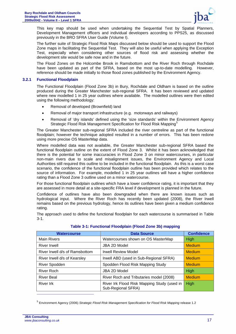
3.2.1 Functional Floodplain
The Functional Floodplain (Flood Zone 3b) in Bury, Rochdale and Oldham is based on the outline produced during the Greater Manchester sub-regional SFRA. It has been reviewed and updated where new modelled 1 in 25 year outlines where available. The modelled outlines were then edited using the following methodology:
• Removal of developed (Brownfield) land • Removal of major transport infrastructure (e.g. motorways and railways) • Removal of ‘dry islands’ defined using the ‘size standards’ within the Environment Agency
Strategic Flood Risk Management Specification for Flood Risk Mapping5 The Greater Manchester sub-regional SFRA included the river centreline as part of the functional floodplain; however the technique adopted resulted in a number of errors. This has been redone using more precise OS MasterMap data. Where modelled data was not available, the Greater Manchester sub-regional SFRA based the functional floodplain outline on the extent of Flood Zone 3. Whilst it has been acknowledged that there is the potential for some inaccuracies in Flood Zone 3 on minor watercourses, in particular non-main rivers due to scale and misalignment issues, the Environment Agency and Local Authorities still required this outline to be included in the functional floodplain. As this is a worst case scenario, the confidence of the functional floodplain outline has been provided which relates to the source of information. For example, modelled 1 in 25 year outlines will have a higher confidence rating than a Flood Zone 3 outline used on a minor watercourse. For those functional floodplain outlines which have a lower confidence rating, it is important that they are assessed in more detail at a site-specific FRA level if development is planned in the future. Confidence of outlines have also been downgraded when there are known issues such as hydrological input. Where the River Roch has recently been updated (2008), the River Irwell remains based on the previous hydrology, hence its outlines have been given a medium confidence rating. The approach used to define the functional floodplain for each watercourse is summarised in Table 3-1.
Table 3-1: Functional Floodplain (Flood Zone 3b) mapping
Watercourse Data Source Confidence Main Rivers Watercourses shown on OS MasterMap High River Irwell JBA 2D Model Medium River Irwell d/s of Ramsbottom Irwell Review Model Medium River Irwell d/s of Kearsley Irwell ABD (used in Sub-Regional SFRA) Medium River Spodden Spodden Flood Risk Mapping Study Medium River Roch JBA 2D Model High River Beal River Roch and Tributaries model (2008) Medium River Irk River Irk Flood Risk Mapping Study (used in
Sub-Regional SFRA) High
5 Environment Agency (2006) Strategic Flood Risk Management Specification for Flood Risk Mapping release 1.2

Bury Rochdale and Oldham Councils Strategic Flood Risk Assessment 2009s0042 - Volume II – Level 1 SFRA
JBA Consulting www.jbaconsulting.co.uk 18
Watercourse
Data Source Confidence Other Flood Zone 3 Low
3.3 Flood Risk Management Measures Maps
Residual risks are the risks that remain after all risk avoidance, substitution and mitigation measures have been taken. The residual risks in Bury, Rochdale and Oldham are therefore related to the occurrence of events of low probability, such as extreme flood events greater than the design capacity of the constrained river system or failure of flood defences. A map of flood risk management measures has been produced for Bury, Rochdale and Oldham. This includes:
• The location of river flood defences (based on the SFRA asset survey) • The coverage of Environment Agency Flood Warning Areas • Areas Benefitting from Defences
This map is very important when considering the residual risks associated with flooding. These residual risks have been investigated in more detail within the BRO Level 2 SFRA.
3.4 Areas Susceptible to Surface Water Flooding Maps
The Areas Susceptible to Surface Water Flooding maps show surface water flood extents assuming a 1 in 200 year rainfall event. The areas susceptible to surface water flooding have been provided on a set of maps covering Bury, Rochdale and Oldham Councils, and are based on information provided in the Environment Agency national Areas Susceptible to Surface Water Flooding Map. The Susceptibility zones are split between:
More Susceptible
Susceptible
Less Susceptible
These maps are extremely helpful in supplementing the PPS25 Flood Zone Maps as they show where localised, flash flooding can cause problems, even if the Main Rivers are not overflowing. This is often due to high intensity rainfall events, which exceed the capacity of sewer systems. As a result, surface water is unable to drain away safely and flooding results. The maps typically show less susceptible areas on tributaries and feeder streams to Main Rivers, where steeper sloping valleys exist and on the edge of the natural floodplain of Main Rivers, again where land levels tend to rise more steeply. The more susceptible areas are predominantly in valley bottoms, in the Main River floodplain or on low lying greenfield land. From the maps it can be seen that there are many areas of land outside Flood Zone 3, that are susceptible to surface water flooding and this needs to be considered as an integral part of the assessment. These maps are also excellent in identifying major flow routes due to the topography of the land, which may intercept critical infrastructure or pass through major developments. These maps are helpful in supporting the Flood Zone Maps during the Sequential Test. In particular they show where susceptible areas are and if development allocations are proposed in these susceptible areas then appropriate avoidance, substitution and mitigation actions are needed. It must be noted that these maps were created at a national level. Where possible flow routes underneath structures (i.e. railway embankments, motorways, bridges etc.) have been including in the underlying topography, but it was not possible at national scale to define all such openings. The capacity of the sewer system in removing a volume of the rainfall or infiltration rates on greenfield land has not been included.
Bury Rochdale and Oldham Councils Strategic Flood Risk Assessment 2009s0042 - Volume II – Level 1 SFRA
JBA Consulting www.jbaconsulting.co.uk 19
The map therefore takes a ‘worst case’ conservative approach in that it assumes that the sewer system is already full, blocked or has failed and that the ground is already saturated prior to rainfall. In such extreme events as summer 2007, it was seen that the drainage system had a limited effect on the location of flooding and saturated ground conditions increased the intensity of the flooding.
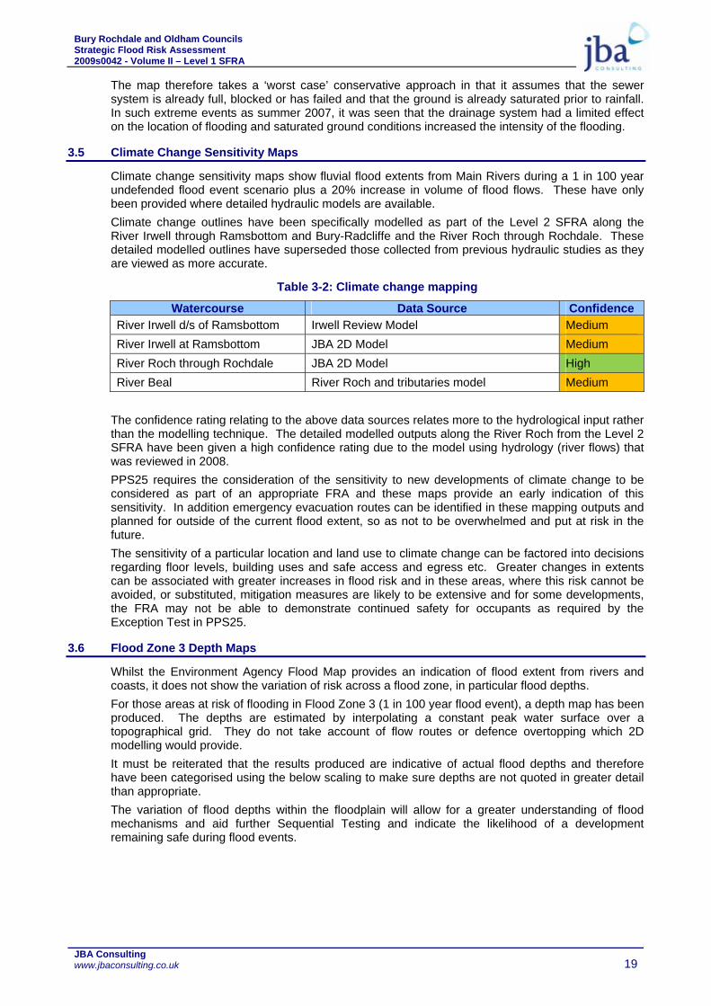
3.5 Climate Change Sensitivity Maps
Climate change sensitivity maps show fluvial flood extents from Main Rivers during a 1 in 100 year undefended flood event scenario plus a 20% increase in volume of flood flows. These have only been provided where detailed hydraulic models are available. Climate change outlines have been specifically modelled as part of the Level 2 SFRA along the River Irwell through Ramsbottom and Bury-Radcliffe and the River Roch through Rochdale. These detailed modelled outlines have superseded those collected from previous hydraulic studies as they are viewed as more accurate.
Table 3-2: Climate change mapping
Watercourse Data Source Confidence River Irwell d/s of Ramsbottom Irwell Review Model Medium River Irwell at Ramsbottom JBA 2D Model Medium River Roch through Rochdale JBA 2D Model High River Beal River Roch and tributaries model Medium
The confidence rating relating to the above data sources relates more to the hydrological input rather than the modelling technique. The detailed modelled outputs along the River Roch from the Level 2 SFRA have been given a high confidence rating due to the model using hydrology (river flows) that was reviewed in 2008. PPS25 requires the consideration of the sensitivity to new developments of climate change to be considered as part of an appropriate FRA and these maps provide an early indication of this sensitivity. In addition emergency evacuation routes can be identified in these mapping outputs and planned for outside of the current flood extent, so as not to be overwhelmed and put at risk in the future. The sensitivity of a particular location and land use to climate change can be factored into decisions regarding floor levels, building uses and safe access and egress etc. Greater changes in extents can be associated with greater increases in flood risk and in these areas, where this risk cannot be avoided, or substituted, mitigation measures are likely to be extensive and for some developments, the FRA may not be able to demonstrate continued safety for occupants as required by the Exception Test in PPS25.
3.6 Flood Zone 3 Depth Maps
Whilst the Environment Agency Flood Map provides an indication of flood extent from rivers and coasts, it does not show the variation of risk across a flood zone, in particular flood depths. For those areas at risk of flooding in Flood Zone 3 (1 in 100 year flood event), a depth map has been produced. The depths are estimated by interpolating a constant peak water surface over a topographical grid. They do not take account of flow routes or defence overtopping which 2D modelling would provide. It must be reiterated that the results produced are indicative of actual flood depths and therefore have been categorised using the below scaling to make sure depths are not quoted in greater detail than appropriate. The variation of flood depths within the floodplain will allow for a greater understanding of flood mechanisms and aid further Sequential Testing and indicate the likelihood of a development remaining safe during flood events.

Bury Rochdale and Oldham Councils Strategic Flood Risk Assessment 2009s0042 - Volume II – Level 1 SFRA
JBA Consulting www.jbaconsulting.co.uk 20
0 – 0.5m
0.5 – 1.0m
1.0 – 1.5m
1.5 – 2.0m
> 2.0m
The BRO Level 2 SFRA has assessed flood depths and hazards using detailed 1D-2D hydraulic models where available. Where this has been done, their output should supersede the depth information provided in this Level 1 SFRA. However, where hydraulic models were not available, this information should give a useful overview of potential depths.
3.7 Summary
Examples of conclusions and further uses of these maps include: • Identifying general extents and depths of Main River flooding, • Comparing flood extents generally and for specific areas, with those shown on the
Environment Agency Flood Zone Maps, • Comparing flood extent and depth relating to existing and future land uses, • Identifying where flooding problems are currently likely, and in the future in terms of:
residential areas, business parks and industrial areas, schools, hospitals and civic buildings, transport activities including road and rail disruption, utility infrastructure such as water and sewage treatment works, pumping stations,
power stations and electricity supply sub stations etc. • Assisting a sequential approach to locating new development in lower flood risk areas,
having first carried out the Sequential Test using the Environment Agency’s Flood Zone Maps,
• Identifying the scope for maximising a sequential approach to the development allocation, including layout and design,
• Identifying areas of floodplain where preparations for emergencies are needed including emergency plans, flood warnings and evacuation etc.,
• Identifying the location of open space areas that currently flood and provide flood storage without causing too much disruption to existing land uses and people and property, and
• Identifying where these flood storage areas might be better utilised in future and locations for potential new flood storage areas, washlands and green infrastructure where development should be avoided.

Bury Rochdale and Oldham Councils Strategic Flood Risk Assessment 2009s0042 - Volume II – Level 1 SFRA
JBA Consulting www.jbaconsulting.co.uk 21
4 SITE SPECIFIC ALLOCATIONS
4.1 Introduction
This Level 1 SFRA should assist Bury, Rochdale and Oldham Councils in carrying out the Sequential Test as outlined in Annex D of PPS25. The Sequential Test is based on proposed development sites, their situation in regards to flood risk, that level of risk and also the developments vulnerability to that risk. When allocating or approving land for development in flood risk areas, those responsible for making development decisions are expected to demonstrate that there are no suitable alternative development sites located in lower flood risk areas. The BRO SFRA User Guide has provided guidance for Spatial Planners, Development Managers and Developers in how to apply the test and should be referred to. The following section provides summary tables of sites assessed in the BRO Level 1 SFRA for each council. One of the main outputs of this assessment is the Sequential Test Spreadsheet discussed below.
4.2 Development Site Sequential Test
A Sequential Test Excel spreadsheet has been produced showing the results of all development sites provided by Bury, Rochdale and Oldham Councils against PPS25 Flood Zones and as an extra layer of information against the Areas Susceptible to Surface Water Flooding map. Area (ha) and percentage (%) cover of each zone is provided. Whilst development sites tested are based on data from each Local Authority, additional sites may also need to be added to the final spreadsheet by the final users once they are identified for development (see Section 2 of SFRA User Guide). Each LPA should use this information to help apply the Sequential Test as described in the BRO SFRA User Guide. They should also use information on flood risk from other sources in their allocation of development (see Section 2 of SFRA User Guide).
Figure 4-1: Screenshot of Sequential Test spreadsheet
A map is also provided which shows the results of the assessment. It identifies each development allocation and colour coordinates them with regards to their location with the PPS25 Flood Zones. • Flood Zone 1 = Green • Flood Zone 2 = Yellow • Flood Zone 3a = Orange • Flood Zone 3b = Red

Bury Rochdale and Oldham Councils Strategic Flood Risk Assessment 2009s0042 - Volume II – Level 1 SFRA
JBA Consulting www.jbaconsulting.co.uk 22
This assessment is straightforward, and identifies risk as the worst case even if that site might have less than 5% within a Flood Zone. The spreadsheet provided gives a greater detail of coverage, including area and percentage cover of flood zones within a development site. Table 4-1, Table 4-2 and Table 4-3 provide a summary of sites investigated from the Sequential Test spreadsheet at risk of fluvial flooding.
Table 4-1: Summary of development sites at risk of fluvial flooding in Bury
Flood Zone 2 Flood Zone 3a Flood Zone 3b
No.
Sites Total Area
(ha) Area (ha) No. Area
(ha) No. Area (ha) No.
ELR Portfolio 33 84.55 5.70 6 13.19 6 0.04 5 Employment Sites 90 114.40 22.79 18 20.18 15 0.26 6 SHLAA Sites 329 200.94 18.34 41 10.75 28 0.42 9 Total 452 399.88 46.82 65 44.12 49 0.72 20
Table 4-2: Summary of development sites at risk of fluvial flooding in Rochdale
Flood Zone 2 Flood Zone 3a Flood Zone 3b
No.
Sites Total Area
(ha) Area (ha) No. Area
(ha) No. Area (ha) No.
Broad Locations 6 887.01 36.65 4 25.85 4 16.50 2 Sites in Employment Zones 17 57.00 2.41 8 4.41 7 0.58 5 Employment Zones 35 596.03 25.65 20 30.36 20 6.88 13 Primary Shopping Areas 3 6.04 0.67 1 0.01 1 0.00 0 Secondary and Central Shopping Areas 5 5.06 0.08 1 0.62 1 0.00 0 SHLAA New Sites 77 136.89 9.04 12 2.79 8 0.89 8 SHLAA Permission 365 520.87 8.69 28 1.92 13 0.33 8 SHLAA Under Construction 58 39.42 0.63 8 2.29 6 0.11 1 RDA Sites 8 27.25 9.01 8 10.84 8 2.54 5 Total 574 2275.57 92.83 90 79.09 68 27.83 42
Table 4-3: Summary of development sites at risk of fluvial flooding in Oldham (Beal catchment)
Flood Zone 2 Flood Zone 3a Flood Zone 3b
No.
Sites Total Area
(ha) Area (ha) No. Area
(ha) No. Area (ha) No.
SHLAA 27 25.96 3.24 5 0.00 1 0.02 3 Primary Employment 2 199.44 17.09 2 6.06 2 0.56 2 Business and Industry 4 22.78 1.71 2 0.22 1 0.03 1 Shopping Centres 1 6.97 0.00 0 0.00 0 0.00 0 Sholver Intervention Area 1 72.97 0.00 0 0.00 0 0.00 0 Strategic Sites 5 284.00 0.05 1 0.51 1 0.00 0 Total 40 612.12 22.09 10 6.79 5 0.61 6

Bury Rochdale and Oldham Councils Strategic Flood Risk Assessment 2009s0042 - Volume II – Level 1 SFRA
JBA Consulting www.jbaconsulting.co.uk 23
Table 4-4, Table 4-5 and Table 4-6 provide a summary of sites investigated from the Sequential Test spreadsheet at risk of surface water flooding.
Table 4-4: Summary of development sites at risk of surface water flooding in Bury
Less
Susceptible Susceptible More Susceptible
No.
Sites Total Area
(ha) Area (ha) No. Area
(ha) No. Area (ha) No.
ELR Portfolio 33 84.55 9.38 28 9.55 19 2.19 12 Employment Sites 90 114.40 12.95 66 17.48 46 7.33 24 SHLAA Sites 329 200.94 20.15 171 17.62 113 9.31 52 Total 452 399.88 42.48 265 44.65 178 18.84 88
Table 4-5: Summary of development sites at risk of surface water flooding in Rochdale
Less
Susceptible Susceptible More Susceptible
No.
Sites Total Area
(ha) Area (ha) No. Area
(ha) No. Area (ha) No.
Broad Locations 6 887.01 54.99 6 65.97 6 45.26 6 Sites in Employment Zones 17 57.00 4.27 14 3.64 15 5.08 10 Employment Zones 35 596.03 50.17 35 72.59 34 40.88 31 Primary Shopping Areas 3 6.04 0.62 3 0.95 3 0.00 0 Secondary and Central Shopping Areas 5 5.06 0.93 4 0.84 4 0.04 2 SHLAA New Sites 77 136.89 11.46 47 13.74 35 11.23 20 SHLAA Permission 365 520.87 43.55 125 34.97 73 17.14 32 SHLAA Under Construction 58 39.42 2.43 26 3.45 17 1.05 14 RDA Sites 8 27.25 1.44 8 4.88 7 5.44 7 Total 574 2275.57 169.9 268 201.0 194 126.1 122
Table 4-6: Summary of development sites at risk of surface water flooding in Oldham (Beal catchment)
Less
Susceptible Susceptible More Susceptible
No.
Sites Total Area
(ha) Area (ha) No. Area
(ha) No. Area (ha) No.
SHLAA 27 25.96 0.84 11 0.84 7 0.08 2 Primary Employment 2 199.44 21.77 2 19.42 2 7.58 2 Business and Industry 4 22.78 3.58 4 2.88 3 0.37 2 Shopping Centres 1 6.97 0.00 0 0.00 0 0.00 0 Sholver Intervention Area 1 72.97 1.46 1 0.49 1 0.00 0 Strategic Sites 5 284.00 33.13 5 18.16 5 14.31 4 Total 40 612.12 60.78 23 41.79 18 22.34 10

Bury Rochdale and Oldham Councils Strategic Flood Risk Assessment 2009s0042 - Volume II – Level 1 SFRA
JBA Consulting www.jbaconsulting.co.uk 24
Bury, Rochdale and Oldham Councils also requested that waste sites within each council area were assessed against the Flood Zones and Areas Susceptible to Surface Water Flooding map. A summary of the results are highlighted below. The list of waste sites was collected from Urban Vision and includes:
• Currently operating landfills across Greater Manchester • Currently operating built waste facilities across Greater Manchester
Table 4-7: Summary of waste sites at flood risk
Flood Zones Surface Water Zones LPA 1 2 3a 3b Less Susceptible More Bury 37 1 3 0 7 1 3 Rochdale 15 5 4 1 4 6 0 Oldham (Beal Catchment) 11 1 0 0 1 0 0
Those waste sites identified at high risk of flooding (Flood Zone 3a, 3b and More Susceptible to surface water flooding are listed below: Flood Zone 3a
• Porsch-Apart Ltd, Harrison Street, Ramsbottom • Irwell Street Metal Co Ltd, Kenyon Street, Ramsbottom • Royden Polythene Ltd, Dumers Lane, Radcliffe • James Hartley Scrap Metals Ltd, Bramford Road, Heywood • Japs of Rochdale, Corporation Road, Rochdale • Rochdale Transfer Loading Station, Entwisle Road, Rochdale • T A Motors, Trafalgar Street, Rochdale
Flood Zone 3b • Mayer Brothers, Roche Vale Mill, Dyehouse Lane, Rochdale
More Susceptible to Surface Water Flooding • Porsch-Apart Ltd, Harrison Street, Ramsbottom • Irwell Street Metal Co Ltd, Kenyon Street, Ramsbottom • A W R Rent a Skip Ltd, Stand Lane, Radcliffe

Bury Rochdale and Oldham Councils Strategic Flood Risk Assessment 2009s0042 - Volume II – Level 1 SFRA
JBA Consulting www.jbaconsulting.co.uk 25
5 SFRA RECOMMENDATIONS
5.1 Introduction
SFRAs are more than a land use planning tool, and can provide a much broader and inclusive vehicle for integrated, strategic and local Flood Risk Management (FRM) assessment and delivery. Since publication of the Pitt Review, it is apparent that SFRAs will provide a central location for data, information and consideration for all flood risk issues relating to flooding from all sources at a local level; and provide the linkage between CFMPs, SMPs, RFRAs, SWMPs and appropriate sustainable land uses over a number of planning cycles. The Bury, Rochdale and Oldham SFRA has provided this pivotal vehicle in the introduction and promotion of a local authority, post Pitt Review, role in local flood management. The SFRA has been produced to be fit for the future, to help communities meet the considerable flood risk management and climate change related challenges that lay ahead. In order to achieve this Bury MBC, Rochdale MBC and Oldham MBC must take a lead role in flood risk management and continue the work of this Level 1 SFRA and increase the understanding and information available on flood risk issues. There are a number of future plans which could provide this comprehensive understanding and acknowledgement of flood risk from all sources. These are outlined below with recommendations of whether or not they would benefit Bury MBC, Rochdale MBC and Oldham MBC.
5.2 Level 2 SFRA
This Level 1 SFRA has provided the evidence base for Bury MBC, Rochdale MBC and Oldham MBC to apply the Sequential Test as set out in PPS25. Whilst the suite of Flood Risk Maps provided will help inform the decision making process and go some way in informing the likelihood of passing the Exception Test, they do not provide the local understanding and the level of detail required to carry out the Exception Test. A detailed Level 2 SFRA should be produced to gain a greater understanding of the flood mechanisms and residual risks, concentrating on specific locations, to provide the data needed to pass part c) of the Exception Test – whether the development will be safe. These specific locations should be apparent where flood risk has been identified within this Level 1 SFRA as a critical issue but development is still required to meet the wider sustainable objectives. The investigations carried out within the Level 2 SFRA will inform the flood risk balance sheet and confirm the sequential approach to site layout and the design of possible mitigation measures. The scope of a Level 2 SFRA is provided in PPS25 and its Practice Guide. It should include the detailed nature of the flood hazard within a flood zone including: • Flood probability • Flood depth • Flood velocity • Rate of onset of flooding
The Level 2 SFRA should also provide information on flood defences including their location, SoP, condition and an assessment of defence breaching and overtopping.
5.2.1 Bury
The RSS advocates that 80% of development should be on previously developed land and Bury have a target to provide 500 new homes every year, alongside developing commercial, industrial, recreational and public services (education, health etc.) sites. The RSS supports regeneration in Bury and there are many derelict or demolished mill sites next to the River Irwell that are coming forward for redevelopment. Strategic sites in Bury and Radcliffe and the development corridor in Ramsbottom are also at risk of flooding. It is understood that AGMA are currently developing a joint working protocol with the Environment Agency that will help set out how the sequential test should be applied in such circumstances.

Bury Rochdale and Oldham Councils Strategic Flood Risk Assessment 2009s0042 - Volume II – Level 1 SFRA
JBA Consulting www.jbaconsulting.co.uk 26
A Level 2 SFRA should be undertaken to consider the residual risk from the overtopping of flood defences in Bury, many of which are privately owned, piecemeal and in various states of repair. The SFRA should consider flood depth and hazard in the floodplain, centring on key development reaches in Ramsbottom and Bury to Radcliffe. The Level 2 SFRA should also consider the interaction of Hutchinson’s Goit (a former mill diversion channel) with the River Irwell and any effect this may have on transferring floodwaters to areas outside of Flood Zones 3 and 2. There is a history of both canal and reservoir flooding in Bury, and the Level 2 SFRA should consider the risk of flooding from the Manchester, Bury and Bolton Canal. Alongside this the SFRA has identified a significant risk of surface water flooding in Ramsbottom and Radcliffe, which should be investigated in more detail. A Level 2 SFRA needs to consider the vulnerability of land uses in the floodplain and how a development can be made safe and acceptable in terms of flood risk where there are wider sustainability reasons, such as regeneration, for the development to go ahead. This includes consideration of mitigation measures. Mitigation measures should be considered on a strategic basis that avoids a piecemeal approach and advocates partnership between the council and the Environment Agency and integration with wider Environment Agency flood risk management works and strategies (e.g. River Irwell CFMP and Upper Irwell Strategy). It is recommended that an Outline Mitigation Strategy is undertaken that considers the wider and cumulative impacts of mitigation and involves master-planning an area from a flood risk perspective. This should cover Chamberhall and Western waterside in Bury and the River Irwell from the railway bridge at Warth Mills to the railway crossing downstream of the East Lancs Paper Mill. The Level 2 SFRA should investigate whether planned development in Bury is likely to have any effect on flood risk downstream in Salford.
5.2.2 Rochdale
The RSS advocates that 80% of development should be on previously developed land and Rochdale have a target to provide 400 new homes every year, alongside developing commercial, industrial, recreational and public services (education, health etc.) sites. The RSS supports regeneration in Rochdale and there are many derelict or demolished former industrial sites and residential areas next to the River Roch that are coming up for redevelopment. The Rochdale Development Agency (RDA) was established by Rochdale MBC in 1993 to lead on regeneration in the borough. Their mission is to make ‘Rochdale borough a more prosperous and vibrant place by encouraging new economic investment and physical development’. The RDA have regeneration plans for Rochdale, Heywood and Middleton, including a new business park at Kingsway in Rochdale, Housing Market Renewal in East Central Rochdale, Kirkholt and Langley and major investment in Rochdale Town Centre (known as the Town Centre East development). Both East Central Rochdale and Town Centre East developments are at a significant risk from flooding from the River Roch. There are known surface water issues in Kirkholt and Heywood. It is understood that AGMA are currently developing a joint working protocol with the Environment Agency that will help set out how the Sequential Test should be applied in such circumstances. A Level 2 SFRA should be undertaken to consider the residual risk from the overtopping of flood defences in Littleborough and Rochdale, some of which are privately owned, piecemeal and in various states of repair. The SFRA should consider flood depth and hazard in the floodplain, centring on key development reaches in Littleborough and Rochdale. This Level 1 SFRA has identified that there is high risk from canal flooding and the Level 2 SFRA should consider the risk of flooding from the Rochdale Canal, including the implications of an embankment breach upstream of Rochdale town centre. Alongside this the SFRA has identified a significant risk of surface water flooding in Littleborough and Heywood, which should be investigated in more detail. A Level 2 SFRA needs to consider the vulnerability of land uses in the floodplain and how a development can be made safe and acceptable in terms of flood risk where there are wider sustainability reasons, such as regeneration, for the development to go ahead. This includes consideration of mitigation measures. Mitigation measures should be considered on a strategic basis that avoids a piecemeal approach and advocates partnership between the council and the Environment Agency and integration with wider Environment Agency flood risk management works and strategies (e.g. River Irwell CFMP, Roch Strategy). It is recommended that an Outline Mitigation Strategy is undertaken that considers the wider and cumulative impacts of mitigation and involves master-planning an area from a flood risk perspective. This should be undertaken for the River Roch where it flows through the East Central Rochdale and Town Centre East regeneration areas.

Bury Rochdale and Oldham Councils Strategic Flood Risk Assessment 2009s0042 - Volume II – Level 1 SFRA
JBA Consulting www.jbaconsulting.co.uk 27
The Level 2 SFRA should investigate whether planned development in Rochdale is likely to have any effect on flood risk downstream in Radcliffe or Salford.
5.2.3 Oldham
The RSS advocates that 80% of development should be on previously developed land and Oldham have a target to provide 289 new homes every year, alongside developing commercial, industrial, recreational and public services (education, health etc.) sites. The RSS supports regeneration in Oldham. This Level 1 SFRA has only considered the River Beal catchment to the north of the council area. Both the Sholver and Derker Housing Market Renewal areas sit wholly or partly within the Beal catchment. Whilst the risk from the River Beal is recognised, there are limited defences and development sites within Shaw in the floodplain that justify undertaking detailed hazard modelling. A more detailed FRA for any development sites that come forward in the future that could be at risk from overtopping or breaching of the limited defences in Shaw should consider residual risk in more detail. More detailed surface water investigations should be undertaken for Sholver and Derker to feed into master planning housing redevelopment in these areas. The Level 2 SFRA should investigate whether planned development in Oldham is likely to have any effect on flood risk downstream in Rochdale, Radcliffe or Salford. It is recommended that a Level 1 SFRA is undertaken for the remaining Oldham MBC Council areas that fall within the catchments of the River Irk, Medlock and Tame. This should fill in the gaps from the Greater Manchester Sub-Regional SFRA and consider all sources of flooding to support application of the Sequential Test. This should make recommendations for a Level 2 SFRA. It should be noted that this Level 1 SFRA has been undertaken as part of a Hybrid Level 2 SFRA for Bury, Rochdale and Oldham. The Level 2 SFRA is provided as Volume III.
5.3 Surface Water Management Plans (SWMPs)
The ‘Pitt Review’, ‘PPS25’, the ‘Making Space for Water - Integrated Urban Drainage’ pilots, the ‘Draft Flood and Water Management Bill’ and draft Surface Water Management Plan (SWMP) guidance recognise the need for clearer roles and responsibilities for different sources of flood risk, with the current legislative framework leading to a fragmented and piecemeal approach for managing urban flood risk. A local leadership role for local flood risk issues has emerged whereby local authorities will need to have in place a strategy to manage these risks, of which a SWMP is an integral part. Surface water flooding is a major source of flood risk and as demonstrated by the summer 2007 floods can lead to serious flooding of property and possessions. These impacts can typically be mitigated through the implementation of established ‘best practice’ drainage techniques including Sustainable Urban Drainage Systems (SUDS) at the planning application stage. However, in some circumstances site constraints dictate that a catchment-wide, holistic approach to surface water flood management is required through urban catchment planning and strategic consideration of the design, construction, maintenance and improvement of sewers and watercourses. Local Authorities need to take a lead role with close liaison between Water Companies and the Environment Agency is essential to ensure a consistent and co-ordinated approach to surface water management and this may be best achieved by the production of appropriate Surface Water Management Plans (SWMPs). SWMPs are developed by a partnership between a Local Authority, Water Company and the Environment Agency. They provide an opportunity to: • Develop a framework for joint working and data sharing (which is a fundamental part of flood
risk management under the draft Flood and Water Management Bill), • Collate a central geographic database of drainage assets and flood risk issues, • Assess the likelihood of surface water flooding through various modelling approaches, • Assess the risk of surface water flooding to people, properties and the environment, • Communicate this risk to local communities, • Assess the costs and benefits of various flood risk reduction measures, • Provide a drainage strategy for areas of significant development if appropriate, and • Provide a framework for implementation and monitoring of the surface water strategy for a
given area.

Bury Rochdale and Oldham Councils Strategic Flood Risk Assessment 2009s0042 - Volume II – Level 1 SFRA
JBA Consulting www.jbaconsulting.co.uk 28
The Defra SWMP guidance is based on the Integrated Urban Drainage pilots undertaken as part of Making Space for Water and was recently tested by six national pilot studies. The government outlined its future intentions towards the development of SWMPs in the Government Response to the Pitt Review into the 2007 floods, setting aside £9.7m for the development of a further 50 SWMPs for high priority locations (which has been decided on a national basis). SWMPs should achieve the level of data sharing with water companies and analysis using detailed sewer network models that is the next stage down from the SFRA. SFRAs provide the opportunity for local authorities to assess at a strategic level the risk from multiple sources of flooding, which can then feed into more detailed assessments where appropriate by both themselves and other operating authorities. This includes the identification of Critical Drainage Areas. Critical Drainage Areas are those identified from historical flood events and/ or modelled data as having a significant risk from surface water flooding and should include drainage catchments for the sewer network, where there is high risk of surface water flooding or the network is at capacity (these were not provided for the SFRA). Recommendations can then be made for the future provision of SWMPs in high risk locations or areas of significant development for which an integrated drainage solution is possible that can reduce flood risk both to the development and elsewhere.
5.3.1 Screening for Critical Drainage Areas
Future Water (Defra, 2008) sets out the role that SFRAs can have in identifying Critical Drainage Areas (CDAs) for which more detailed Surface Water Management studies can be developed. The recent Defra Surface Water Management Plan Guidance (2009) supports the use of SFRAs in providing the evidence base for where SWMPs are required. The SFRA has identified CDAs based on natural catchments and known flooding problems. United Utilities network and flood risk data was not available for use in this SFRA. The sewer network can have a significant impact on the location of surface water and sewer flooding for more frequent events. It can also affect the distribution of water throughout urban catchments during flood events, passing excess flows from the combined network into watercourses through combined sewer overflows. The CDAs identified here should therefore only be taken as a starting point in the identification of areas for which a SWMP would be beneficial. Where sewer systems are interconnected across the boundaries of natural catchments, the additional catchments of the sewers should be taken into account when finalising SWMP boundaries in areas where there is a high risk of sewer flooding, known historic flooding incidents or the sewer network is at capacity. The catchments of sewers often encompass more than one local authority. Screening for CDAs within the Bury, Rochdale and Oldham (Beal catchment) authority areas was undertaken for the SFRA, using data from the following sources: • Local authority incident records • Discussions with Local Authority Drainage Engineers • The National Surface Water Map • United Utilities DG5 register
The table below defines the Critical Drainage Areas that have been defined from the surface water flooding information available at this time. Development in Oldham is included as it has the potential to increase fluvial flood risk downstream in Rochdale.
Table 5-1: Screening for Critical Drainage Areas
Local Authority
Area Description Take forward as CDA?
Oldham Sholver/ Derker
Sholver neighbourhood and Derker Housing Market Renewal Area are potential regeneration and growth points Increased development here has the potential to increase flood risk downstream in Rochdale. If sustainable surface water management can be built into the development layouts then areas of
Yes – need to be recognised as opportunity to reduce flood risk downstream

Bury Rochdale and Oldham Councils Strategic Flood Risk Assessment 2009s0042 - Volume II – Level 1 SFRA
JBA Consulting www.jbaconsulting.co.uk 29
Local Authority
Area Description Take forward as CDA?
new development can help to reduce flood risk downstream.
Rochdale Littleborough National surface water map shows a risk of property flooding Known issues at Calder Avenue and Harehills Park Development planned for this area
Yes – known issues and national Areas Susceptible to Surface Water Flooding map suggest significant risk
Rochdale Kirkholt National Areas Susceptible to Surface Water Flooding map shows a risk of property flooding Known issues with surface water flooding Regeneration is planned for this area
No – a detailed drainage study was undertaken here in 2006. Refining the surface water flood risk in this location will not be of any further benefit to identifying problems in this area, since the detailed drainage study has already done this and this has led to maintenance improvements which should reduce the likelihood of surface water flooding in the future.
Rochdale Heywood National Areas Susceptible to Surface Water Flooding map shows a risk of property flooding 20 properties flooded from surface water in 2006 Known issues on Pilsworth Road and from Millers Brook Known issues with sewer capacity Development planned for this area
Yes – known issues and national Areas Susceptible to Surface Water Flooding map suggest significant risk Sewer system is at capacity which may suggest that surface water flooding happens frequently.
Bury Ramsbottom National Areas Susceptible to Surface Water Flooding map shows a risk of property flooding Known issues on Dick Field Clough and stream to south with surface water flowing along roads and through development areas Development planned for this area Known issues with sewer capacity
Yes – known issues and national Areas Susceptible to Surface Water Flooding map suggest significant risk Sewer system is at capacity which may suggest that surface water flooding happens frequently.
Bury Radcliffe National Areas Susceptible to Surface Water Flooding map shows a risk of property flooding Known issues on Water Street and Pilkington Way Known issues with sewer capacity Development planned for this area
Yes – known issues and national Areas Susceptible to Surface Water Flooding map suggest significant risk Sewer system is at capacity which may suggest that surface water flooding happens frequently.
It is recommended that more detailed surface water modelling is undertaken for the six selected CDAs at Level 2 assessment. The National Surface Water Map provides a good indication of areas at risk of surface water flooding but this should be refined so that it picks up flow paths along roads and around buildings. The risk to properties can then be assessed with more confidence to provide recommendations for SWMPs.

Bury Rochdale and Oldham Councils Strategic Flood Risk Assessment 2009s0042 - Volume II – Level 1 SFRA
JBA Consulting www.jbaconsulting.co.uk 30
Until a SWMP has been completed, all developments identified at risk from surface water flooding should adhere to the guidance in PPS25 and the recommendations outlined in this SFRA. Integrated drainage solutions should be prepared for larger sites or areas. Where major flow paths have been identified these should be considered in the master planning of the site and the sequential placement of development. Where available, SUDS techniques should be identified within the development at the earliest possible stage.
5.4 Water Cycle Studies (WCS)
Water Cycle Studies (WCSs) are an all encompassing study of the capacity in water supply, waste water infrastructure and water in the environment, aimed at those regions that are expecting growth. Its main aim is to ensure that new development can be supplied with the required water services it needs in a sustainable way. To ensure that growth at a council scale can be supplied with sufficient water supply and wastewater treatment facilities, without detrimentally affecting the natural water cycle, it is essential to consider the water infrastructure needs as early in the planning process as possible. A WCS will provide Bury, Rochdale and Oldham Councils and development organisations with the necessary planning tool for this purpose and the planning base to support their LDF. A SWMP and a WCS should be twin tracked when they are prepared for the areas of interest. Whilst the SWMP would address surface water management the remaining issues of water supply and sewage treatment should be included within the WCS. A North West Water Cycle Scoping Study is currently underway to inform and facilitate the undertaking of outline water cycle studies for the six North West Growth Points, of which Greater Manchester is one. The report recommends that a Water Cycle Study is undertaken for the River Mersey, which will include local authorities from AGMA, Mid Mersey, Mersey Heartlands and West Cheshire. Until the River Mersey WCS is prepared, developers should consult with United Utilities about potential capacity issues in the water supply and sewage treatment networks.
5.5 Green Infrastructure Framework
The Green Infrastructure (GI) of Bury, Rochdale and Oldham is part of the council area’s life support system. It is a planned and managed network of natural environmental components and green spaces that intersperse and connect the urban centres, suburbs and rural fringe. In general GI consists of: • Open Spaces – parks, woodlands, nature reserves, lakes • Linkages – River corridors and canals, pathways and cycle routes and greenways • Networks of “urban green” – private gardens, street trees, verges and green roofs.
The identification and planning of GI is critical to sustainable growth. It merits forward planning and investment as much as other socio-economic priorities such as health, transport, education and economic development. GI is also central to climate change action and is recurring theme in planning policy statements, the regional spatial strategy and the sub-regional SFRA. With regards to flood risk, green spaces can be used to manage storm flows and free up water storage capacity in existing infrastructure to reduce risk of damage to urban property, particularly in city centres and vulnerable urban regeneration areas. GI can also improve accessibility to waterways and improve water quality, supporting regeneration and improving opportunities for leisure, the local economy and biodiversity. This evidence base provided in this SFRA should be used to enhance the Greater Manchester Green Infrastructure Study. River corridors identified as functional floodplain are an excellent linkage of GI and can provide storage during a flood event. Areas identified within the urban environment or upstream of a critical surface water flood areas should be incorporated into council GI strategies. Opening up land to create flow paths or flood storage areas can help protect current and future property.

Bury Rochdale and Oldham Councils Strategic Flood Risk Assessment 2009s0042 - Volume II – Level 1 SFRA
JBA Consulting www.jbaconsulting.co.uk
APPENDICES

Bury Rochdale and Oldham Councils Strategic Flood Risk Assessment 2009s0042 - Volume II – Level 1 SFRA
JBA Consulting www.jbaconsulting.co.uk
Appendix A: - Maps