bush fire investigation report - department of fire … 1 of 16 bush fire investigation report...
TRANSCRIPT

Page 1 of 16
Bush Fire Investigation Report
PRIMARY DFES FIRE
INVESTIGATOR
Fire Investigation Officer (FIO): Brynn WEIR
INCIDENT NUMBER/s
2013236076 & 2013236077
INCIDENT DATE
Thursday 28 February 2013
LOT NUMBER
N/A
STREET / ROAD NAME
Initially: Railway Parade (cross) Oakover Road & 303 Cathedral Avenue
SUBURB/s
Middle Swan & Baskerville Western Australia
MAP AND GPS REFERENCE
Railway Parade Middle Swan –
(1) 31o 50’ 53”S 116
o 01’ 11”E
(2) 31o 50’ 49”S 116
o 01’ 11”E;
(3) 31o 50’ 47”S 116
o 01’ 11”E
TIME OF CALL
DFES Incident Reports created at 11:54 &12:03 hours respectively.
STATIONS ATTENDING
Bushfire with significant response by the Department of Fire and Emergency
Services (DFES) Metropolitan, DFES Air Services, Local Government
Brigades and the Department of Environment and Conservation (DEC).
OTHER AGENCIES Given the size and magnitude of this bushfire a range of combat and
support agencies responded to assist DFES and DEC manage this incident.
CAUSE DETERMINATION
ACCIDENTAL.
BRIEF DESCRIPTION OF
CAUSE
Suspected heated emission’s from a passing train igniting vegetation along the rail corridor. All other potential fire causes have been eliminated.
SUPPORT RECORDS FOR THE REPORT
Bureau of Meteorology (BOM) Weather report. Fire Weather Warnings
DFES Air Intelligence
Witness Statements
Electronic Media
FIRE WEATHER CONDITIONS
Australian Bureau of Meteorology Western Australia (BOM)
Fire Weather Forecast – Lower West District of Western Australia

Page 2 of 16
DISCLAIMER
The Department of Fire and Emergency Services (DFES) and its employees accept no responsibility for any loss or damage, whether direct or consequential, suffered by any person as the result of or arising from the reliance on the statements, information or opinions in the document. Furthermore, it is not the intention of this report to pass judgment on, or fix liability for, the loss of property or the effects upon the occupants, following the fire. This report is based upon the evidence and information that was available at the time of investigation. It does not preclude other possible sources of ignition, given the production of additional factors or evidence after that date and at the time of writing this report.
COPYRIGHT No part of this publication may be reproduced, stored in a retrieval system or transmitted in any form or by any means – electronic, mechanical, photocopying, recording or otherwise – without the prior written permission of the copyright owner. Copyrighted materials, reproduced herein are used under the provisions of the Copyright Act 1968 (Cth) as amended, or as a result of application to the copyright owner.
PRIVACY PRINCIPLES DFES adheres to the 11 Information Privacy Principles as outlined in the Privacy Act 1988. As such, DFES requests that personal information contained within this document is treated according to those 11 Information Privacy Principles and is not discussed or distributed outside your organisation without first gaining approval to do so from DFES.
Page 3 of 16
BASIS FOR INVESTIGATION AND REPORT: Section 12 of the Bush Fires Act 1954 (the BF Act) allows the FES Commissioner to designate a departmental officer as a bush fire liaison officer (BFLO). Fire investigation officers have been designated as BFLOs. Pursuant to section 14 of the BF Act a BFLO is empowered to enter any land or buildings to investigate the cause and origin of a fire which has been burning on the land or building. Section 34 of the Fire Brigades Act 1942 allows a member of a fire brigade to remove and keep possession of any materials which may tend to prove the origin of a fire. NOTE ON REPORT: This report provides information on a series of fires that occurred on Thursday 28 February 2013. The first reported fire in the series of fires is recorded by the DFES as incident number 2013236076. This was the most southerly of the fires and occurred adjacent to the railway line between George and Oakover Roads Middle Swan. Figure 4 in this report illustrates the location of the ignition points for this fire. The fire origin and cause determination examination and investigation are centred on this incident. Subsequent to this first fire (2013236076) other fires were reported along the railway line adjacent to and also well to the north of Oakover Road. This series of fires joined together to become one much larger fire which extended into Walyunga National Park and the Avon Valley. This fire is recorded by DFES as 2013236077. It is this fire that caused the evacuation of Bullsbrook, Shady Hills and other suburbs. 1. BACKGROUND:
At 11:54 hours on Thursday 28 February 2013 the Department of Fire & Emergency Services (DFES) Communications Centre received a series of triple zero emergency calls reporting a bushfire in the vicinity of Railway Parade and Oakover Road Middle Swan. This incident is recorded as DFES Incident number 2013236076. The DFES Communications Centre dispatched DFES Midland and Bassendean Career Fire & Rescue Service (FRS) appliances to investigate the area and suppress any fire. Subsequent to the dispatch of the Midland & Bassendean FRS, the DFES Communications Centre started receiving further triple zero calls reporting a number of fires along the Forrestfield - Toodyay railway line which is constructed through the Middle Swan, Herne Hill and Baskerville areas. This series of fires was north of Oakover Rd Middle Swan and is recorded as DFES incident number 2013236077. The maximum temperature recorded at the Perth Airport at 15:00 hours on Thursday 28 February 2013 was 33.1 degrees Celsius (Figure 1). The Bureau of Meteorology (BOM) had issued a fire danger rating for the Lower West Coast of “High” as the Grass Fire Danger Index was 18 (Figure 2). Fire Fighters contained these series of fires within 24 hours. Total control of all fire activity was recorded at 15:15 hours on Saturday 2 March 2013. Several days later, after constant patrol and monitoring, the fires were totally extinguished. During fire suppression five Fire Fighters were injured. Three of the Fire Fighters required hospitalisation: one Fire Fighter suffered smoke inhalation, one sustained a dislocated shoulder and one had a finger crushed. The two remaining Fire Fighters were treated on-site by St John Ambulance personnel: one sustained a cut to the hand and one injured his neck while working on the fire line.
The fire destroyed privately owned sheds, static railway wagons used for storage on private property and also burnt 1,460 hectares of bush and farming land. In addition, the fire damaged fallow pasture, crops and many kilometres of fencing. There was significant damage and disruption to critical infrastructure. Losses were also incurred to electrical distribution lines across the area.

Page 4 of 16
2. FIRE RESPONSE: The first arriving fire crew at incident number 2013236076, which occurred between George and Oakover Roads, was the Midland FRS. This crew requested additional fire fighting resources within five minutes of arrival. This fire, in a paddock between George and Oakover Roads in Middle Swan, was developing rapidly as it was being fanned by strong winds with flames estimated to be up to one metre in height. The fire was spreading through stubble, grass, scrub and bush towards properties in Middle Swan along the Great Northern Highway and surrounding areas downwind (west) of the fire. On arrival at the scene, the Midland FRS crew immediately identified multiple ignition points near or adjacent to the rail line. The DFES Communications Centre was advised of this by radio transmission. As per the DFES mobilisation protocols, Local Government Bushfire Fire Control Officers (BFCO) were mobilised as it was clear that a second series of fires (known as 2013236077 and which occurred almost simultaneously north of Oakover Road) were in a Local Government fire control area. Consequently, fire suppression activities would involve Local Government Bush Fire Brigades (BFB) which were initially managed by the Local Government FCO’s. Staff from the DFES Belmont Regional Office were also mobilised to support the local BFB & FRS. In addition, units from the DFES Volunteer Fire & Rescue Services (VFRS) were also mobilised. Under Section 13(4) of the Bush Fires Act 1954, the City of Swan transferred incident control to the DFES at 12:30 hours on Thursday 28 February 2013 to manage command and control functionality. A wide range of resources and technical expertise from the DFES and other agencies had already been mobilised when transfer of control to the DFES occurred. On the first evening of the fire, more than 280 Fire Fighters from the Local Government Volunteer Bush Fire Brigades, the Career/Volunteer Fire & Rescue Services, (then) Department of Environment & Conservation staff and plant contractors were involved in fire containment. Many fire suppression crews were mobilised from areas external from the City of Swan area. These included, Armadale, Baldivis, Bedfordale, Bridgetown, Browns Road BFB, Byford, Jandakot, Jarrahdale, Keysbrook, Manjimup, Roleystone, Singleton and others.

Page 5 of 16
3. WEATHER CONDITIONS:
It is the advice of the Bureau of Meteorology that the Perth Airport weather recordings are the most relevant to the incidents as they are regarded as being the most applicable to the Baskerville area. This is on the basis of; that of the available automatic weather station sites, the Perth Airport would be the most representative site for fires at their current location. The Perth Airport is located a similar distance from both the west coast and the Darling Escarpment. This means that any changes in wind strengths or directions at the fire site would be well represented by observations from the Perth Airport. Temperatures at the Perth Airport were recorded to be 33.1
oC. Winds were recorded at 24 kilometres per
hour predominantly from the east at 09:00 hours and 19km/h from the east at 15:00 hours. The temperature had been in the mid thirty degree range for the previous three days. Curing (dryness of vegetation) can be considered to have been 100%. Overall, similar weather conditions had been experienced for the whole month of February 2013. Consequently the average maximum temperature for the month of February 2013 was 34.6 with average wind speeds recorded as 25.8 kilometres per hour.
Figure 1

Page 6 of 16
Figure 2

Page 7 of 16
The combination of these weather factors meant that there was an abundance of fine, dry fuel available to any fire that occurred. In terms of fire spread, a fine, cured fuel in combination with a consistently strong wind on a warm day (as indicated) can produce the worst possible conditions. These conditions make fire control and suppression extremely difficult. Bureau of Meteorology weather observations for Thursday 28 February 2013 are as described in the table below (Figure 3):
Date Time Wind direction
Wind Speed (kts)
Wind Speed (km/h)
Temperature Dewpoint RH FDI
28 08:00 90 17 31 22.3 10.2 46 16
28 08:30 80 15 28 23.5 10 42 14
28 09:00 90 13 24 24.9 9.8 38 12
28 09:30 80 13 24 26 9.9 36 13
28 10:00 110 12 22 27.4 10.3 34 12
28 10:30 110 11 20 28 9.5 31 12
28 11:00 100 13 24 29.5 9.2 28 17
28 11:30 90 14 26 29.1 9.1 29 18
28 12:00 90 14 26 30 7.9 25 20
28 12:30 90 11 20 31.2 7.1 22 16
28 13:00 80 13 24 31.6 6.9 21 21
28 13:30 90 15 28 31.8 6.4 20 27
28 14:00 130 13 24 32.4 5.6 19 23
28 14:30 100 11 20 33.3 4.8 17 19
28 15:00 60 9 19 33.1 3.6 16 15
28 15:30 90 11 20 33.6 2.9 14 20
28 16:00 70 7 13 34.2 3.6 15 11
28 16:02 120 15 28 33.9 2.8 14 34
28 16:30 90 13 24 33.5 2.7 14 26
28 17:00 90 12 22 33.6 3.3 15 23
28 17:30 120 15 28 33.1 3.7 16 31
28 18:00 100 14 26 32.5 1.9 14 29
28 18:30 110 14 26 31.5 1.9 15 27
28 19:00 110 9 17 30.6 1.7 16 14
28 19:30 110 7 13 28.1 5.4 24 8
28 20:00 130 7 13 26.3 7.8 31 6
28 20:30 130 6 11 25.1 7.6 33 5
28 21:00 130 6 11 23.7 6.1 32 5
28 21:30 140 7 13 22.7 6.8 36 5
28 22:00 140 7 13 22.6 7.7 38 5
28 22:30 130 9 17 20.4 6.3 40 6
28 23:00 120 9 17 20.1 6.4 41 6
28 23:30 70 4 7 22.2 4.8 32 3
28 24:00 60 7 13 22.9 4.2 30 6
Figure 3. 4. INITIAL INVESTIGATION: Under protocols, due to the magnitude of the fire, the DFES Fire Investigation & Analysis Unit (FIAU) were mobilised to the area to establish the origin and cause of the fire. Fire Investigation Officer (FIO) Brynn WEIR was the DFES primary investigation officer. The DFES FIAU District Officer Gary BAXTER conducted preliminary investigations by phone from the DFES Emergency Services Centre at Cockburn. These investigations included contacting persons who placed triple zero calls. These persons were identified by analysing the DFES Call Line Identification (CLI) data base. The callers were contacted with a view to obtaining and recording their observations regarding the fires that they had reported. Some of these callers were subsequently contacted at a later date so formal statements could be compiled for the investigation.

Page 8 of 16
First arriving fire crews were also contacted to assist in establishing the general area of origin of the fire. A further review of information from DFES incident records revealed that the first responding fire crews to the Oakover/George Road incident had informed the Communications Centre that they believed the fire to which they had been responded was one of a series of fires that were adjacent to the train line. After consultation with the Office of Rail Safety, contact was made with an AURIZON RAIL
supervisor by District Officer Gary
BAXTER with the intent of getting any trains using this line stopped. A goods or freight train was identified as having passed through this location shortly before fire reports were received by the Communications Centre. The train identified was an empty iron ore train travelling north on the rail line which passes through Middle Swan and Baskerville. The train then takes the north-eastern branch of the line at the Millendon Junction (adjacent to Beryl Avenue & Railway Crescent Millendon). Its destination was the iron ore mine at Mount Walton. Initially, train controllers could not communicate with the train drivers as for seven minutes AURIZON RAIL had lost contact with the train. During this time the train continued to travel in a north-east direction through the Avon Valley. BROOKFIELD
Train Control diagrams show that at 11:56 hours the train passed through
the Millendon Junction. The Millendon Junction is approximately four kilometres north of where the first fires were reported at 11:54 hours at Oakover/George Roads and Railway Parade. (Note that between Lennard & Argyle Streets the parallel roads either side of the railway are known as Railway Parade (East) & Railway Crescent (West)). Eventually contact was re-established with the train and the drivers were directed to stop the train. The train stopped at a location adjacent to the 46 kilometre peg. This peg (along the rail line) is 46km from the Perth Central Business District and is approximately 23 km from the area of ignition of the first reported fire at George and Oakover Roads Middle Swan. FIO WEIR travelled to the Walyunga/Avon Valley (2013236077) Incident Control Point which had been established at the East Swan Fire Station. At this location FIO WEIR liaised with Mr Mal KAINS (Incident Investigation Manager for BROOKFIELD) and discussed a joint inspection of the train which was stopped at the 46km peg. The inspection of the train was conducted by FIO WEIR in the company of Mr KAINS and other BROOKFIELD/AURIZON RAIL representatives. The stationary train was inspected thoroughly by FIO WEIR, Mr Mal KAINS, Mr Neil SCUDDS (Wagon Services Manager, AURIZON RAIL) and Mr Rasheed HASSAN (Team Leader, Wagons). Mr KAINS and Mr SCUDDS informed FIO WEIR of various common indicators that may be present to identify any faults that may have occurred. These indicators include, but are not limited to, the following;
Discolouration; “Blueing” of the wheel hubs indicating that a bearing may have overheated,
Flat spots on the rail contact surface of the wheel indicating a similar but more serious problem,
The apparent leakage of bearing lubrication material,
The absence of brake shoes or portions of brake shoe material,
Any “contamination” of brake shoes (the introduction of unwanted foreign material between brake shoe and the wheel contact surface),
Flat spots on the wheels (which can be caused by “contamination”) or the introduction of introduced, foreign materials to the rolling stock. These items may include; metal fence pickets, fencing wire or shopping trolleys, acts of vandalism.
During the inspection a bearing on one of the carriages was identified with a possible anomaly. This was due to the carriage having a slightly different bearing configuration to the majority of the other wagons. In Mr SCUDDS opinion this would not reasonably be considered as a cause. Mr SCUDDS explained that the slightly different configuration was due to the use of a different brand of bearing. The axle concerned used a “Timken” brand bearing whereas the majority of the other axles used a “Fag” brand bearing. Consequently the differing bearings utilised different lubrication sealing systems. The slightly exposed axle on the “Timken” system gave the impression that it was not seated properly. It was Mr SCUDDS’ view that despite the slightly exposed axle the bearing was seated and operating correctly. The axle displayed no sign of “blueing” nor were there any flat spots on the wheel. There was no damage on the wheel’s circumference evident. After the full length of the train was inspected on several occasions the group discussed all possible outcomes. Mr SCUDDS highlighted that nothing of any significance was discovered. All connections of both airlines and physical wagon connections were checked. All wheels were checked individually as was each brake assembly. There was nothing irregular detected. All wheels, brake assemblies and air lines appeared to be whole and in good order and all hand brake assemblies were in the “off” position. Mr SCUDDS maintained that there was no evidence of any damaged, missing, overheated, worn or additional items located during the search.
Page 9 of 16
The Department of Transport Rail Safety Regulator Mr Rob BURROWS was also requested to provide DFES with a copy of any report compiled by the OFFICE OF RAIL SAFETY. Through Mr Rob BURROWS, Mr Clive WEAIRE (Rail Safety and Rolling Stock Manager, OFFICE OF RAIL SAFETY) stated that investigation reports would be provided to DFES and OFFICE OF RAIL SAFETY by BROOKFIELD/AURIZON RAIL as any OFFICE OF RAIL SAFETY investigation would only duplicate findings determined by a BROOKFIELD/AURIZON RAIL investigation. 5. IDENTIFICATION OF A GENERAL AREA OF ORIGIN
1:
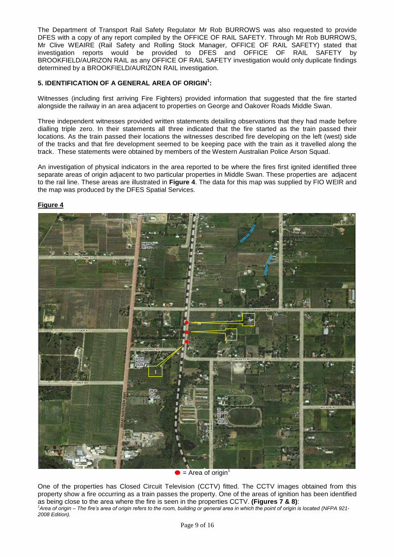
Witnesses (including first arriving Fire Fighters) provided information that suggested that the fire started alongside the railway in an area adjacent to properties on George and Oakover Roads Middle Swan. Three independent witnesses provided written statements detailing observations that they had made before dialling triple zero. In their statements all three indicated that the fire started as the train passed their locations. As the train passed their locations the witnesses described fire developing on the left (west) side of the tracks and that fire development seemed to be keeping pace with the train as it travelled along the track. These statements were obtained by members of the Western Australian Police Arson Squad. An investigation of physical indicators in the area reported to be where the fires first ignited identified three separate areas of origin adjacent to two particular properties in Middle Swan. These properties are adjacent to the rail line. These areas are illustrated in Figure 4. The data for this map was supplied by FIO WEIR and the map was produced by the DFES Spatial Services. Figure 4
= Area of origin1
One of the properties has Closed Circuit Television (CCTV) fitted. The CCTV images obtained from this property show a fire occurring as a train passes the property. One of the areas of ignition has been identified as being close to the area where the fire is seen in the properties CCTV. (Figures 7 & 8): 1Area of origin – The fire’s area of origin refers to the room, building or general area in which the point of origin is located (NFPA 921-
2008 Edition).
1
2
3

Page 10 of 16
6. REFINING THE AREA OF ORIGIN: With strong evidence suggesting that the fire originated within the rail corridor FIO WEIR commenced to track the path of the fire. The objective was to locate and identify all available fire travel indicators. These fire travel indicators would be used to reduce the general area of origin to a more specific area of origin in an effort to ultimately establishing the point of origin
1 for the fire.
Using information provided by witnesses, first arriving fire crews, remaining combustible indicators, non-combustible indicators and physical barriers on the ground, FIO WEIR was able to reduce the general area of origin to a more defined area of origin. A comprehensive examination of fire travel indicators included:
Locating and examining smoke staining on physical barriers and features (rocks, mounds, fence posts etc).
Locating and examining scorch patterns on physical barriers (stumps, trees, fence posts, grasses).
Locating and examining unburnt foliage around rocks and other static barriers.
Locating and examining ash deposits on barriers (vegetation, fence posts, fencing wire, rocks, mounds etc).
Locating and examining fallen debris.
Locating and examining leaf freeze.
Locating and examining remains of standing vegetation.
Locating and examining smoke staining, scorching and/or ash deposits on introduced features such as reticulation piping, sheds, household articles etc.
Three primary areas were identified as specific areas where ignition occurred. These three areas have been geographically mapped and are as illustrated by Figure 4. As evident by the illustration, these three fire seats are adjacent to the rail line within the rail corridor and are between the end of George Road and the rail crossing at Oakover Road Middle Swan. These geographical points are identified by the following GPS (Global Positioning System) coordinates;
1. 31o 50’ 53”S 116
o 01’ 11”E (Figure 5)
This is the most southerly of the ignition points and is located within the area of origin between the rail line and the property fences (Area of origin Point 1).
2. 31
o 50’ 50”S 116
o 01’ 11”E (Figure 6)
This is the middle point as illustrated in Figure 4 and is also located between the rail line and the property fences (Area of origin 2).
3. 31o 50’ 47”S 116
o 01’ 11”E (Figures 7 & 8)
This is the top ignition point illustrated on the map and is the most northerly ignition point for the purposes of the investigation into Incident 236076. This is in the area where a fire starts that is captured on the CCTV obtained from a private residence (Area of origin 3).
1 Point of origin – The exact physical location where a heat source and a fuel come in contact with each other and a fire begins (NFPA 921-2008 Edition)

Page 11 of 16
Figure 5. Area of origin 1 @ 31o 50’ 53”S 116
o 01’ 11”E
Figure 6. Area of origin 2 @ 31o 50’ 50”S 116
o 01’ 11”E
Area of Origin 1
Area of Origin 2

Page 12 of 16
Figure 7. Area of origin 3 @ 31o 50’ 47”S 116
o 01’ 11”E
Figure 8. Area of origin 3 @ 31o 50’ 47”S 116
o 01’ 11”E
Area of ignition
Area of Origin 3
Area of Origin 3
Property from which CCTV was recorded.
Page 13 of 16
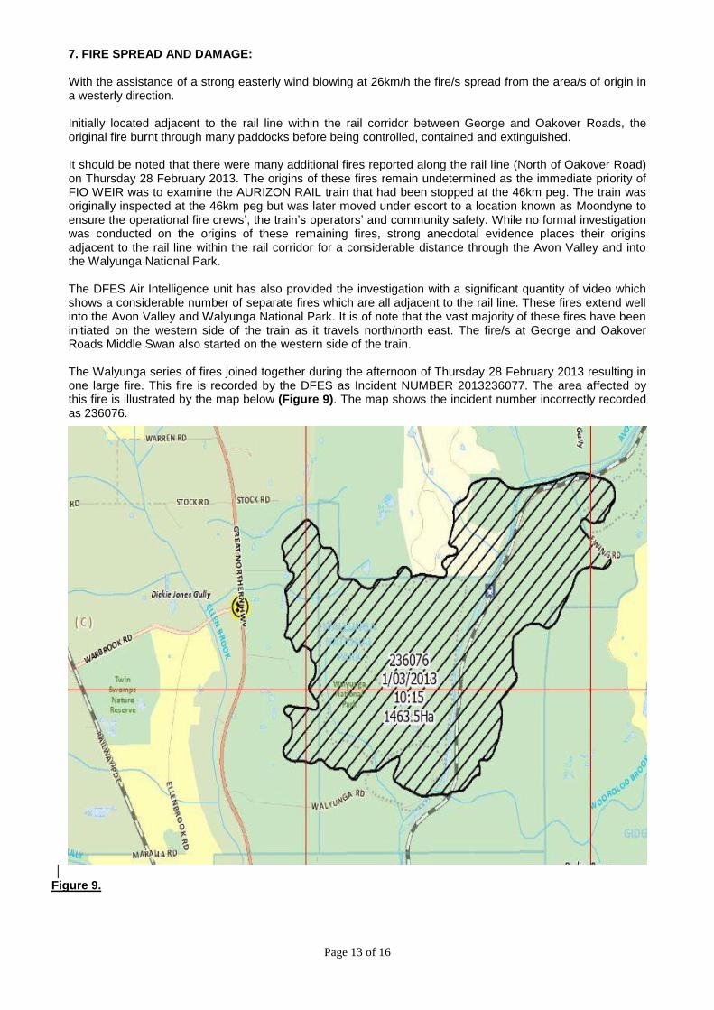
7. FIRE SPREAD AND DAMAGE: With the assistance of a strong easterly wind blowing at 26km/h the fire/s spread from the area/s of origin in a westerly direction. Initially located adjacent to the rail line within the rail corridor between George and Oakover Roads, the original fire burnt through many paddocks before being controlled, contained and extinguished. It should be noted that there were many additional fires reported along the rail line (North of Oakover Road) on Thursday 28 February 2013. The origins of these fires remain undetermined as the immediate priority of FIO WEIR was to examine the AURIZON RAIL train that had been stopped at the 46km peg. The train was originally inspected at the 46km peg but was later moved under escort to a location known as Moondyne to ensure the operational fire crews’, the train’s operators’ and community safety. While no formal investigation was conducted on the origins of these remaining fires, strong anecdotal evidence places their origins adjacent to the rail line within the rail corridor for a considerable distance through the Avon Valley and into the Walyunga National Park. The DFES Air Intelligence unit has also provided the investigation with a significant quantity of video which shows a considerable number of separate fires which are all adjacent to the rail line. These fires extend well into the Avon Valley and Walyunga National Park. It is of note that the vast majority of these fires have been initiated on the western side of the train as it travels north/north east. The fire/s at George and Oakover Roads Middle Swan also started on the western side of the train. The Walyunga series of fires joined together during the afternoon of Thursday 28 February 2013 resulting in one large fire. This fire is recorded by the DFES as Incident NUMBER 2013236077. The area affected by this fire is illustrated by the map below (Figure 9). The map shows the incident number incorrectly recorded as 236076.
Figure 9.

Page 14 of 16
DFES has recorded the damage to date as being:
Sheds,
1463.5 hectares of bush and pasture,
Stock losses,
Farm machinery,
Fencing,
Natural and planted vegetation,
Road signs,
Power infrastructure,
Fauna,
Vehicles. The image below indicates the damage sustained to two static railway wagons used for storage on a property near the fire’s (236076) area of origin (Figure 10).
Figure 10.
Static rail wagons within private property.

Page 15 of 16
8. POTENTIAL IGNITION SOURCES WITHIN OR NEAR THE AREA OF ORIGIN: The investigation considered a number of accidental, incendiary and natural ignition sources within or near the area of origin of Incident 236076 including:
Lightning: The Bureau of Meteorology reports that there was no lightning activity recorded in the South West Land Division on the day of the Thursday 28 February 2013. Eliminated as a cause.
Vehicle movements: Witnesses had not seen any vehicles adjacent to the areas in which the fires started prior to the fire. Railway Parade is too far from the area of origin for moving vehicles to be considered possible ignition sources. There was no evidence (tracks or otherwise) of vehicle movements adjacent to the areas of origin. Eliminated as a cause.
Cigarette: The fire line is too far west of Railway Parade for a discarded cigarette to be the cause of the fires investigated. No other fire seats were located between the road side and the fire line. There are no walking tracks present in the area of origin and nor were any persons detected in closed circuit imagery or observed by witnesses. Note: The possibility of individual cigarette ends being discarded from within the train in a similar fashion in a sequence to ignite vegetation at periodical distances was considered however no evidence of this was found and it is considered highly unlikely. Eliminated as a cause.
Camping or camp fires: No evidence of camping or camp fires were present. Eliminated as a cause.
Spontaneous heating: No hay from harvesting or residue of any other product that could have self-heated was found in the areas of origin. Eliminated as a cause.
Chemical: There was no evidence of any chemical residue, chemical reaction or apparatus found in any of the areas of ignition. Eliminated as a cause.
Vandalism: No evidence of vandalism or criminal intent within the areas of origin was located. (e.g. foreign objects; wire or metal chain thrown on rail lines or at rail engines and wagons).
Note: The rail operators have front viewing CCTV fitted to the front locomotive. After review of this vision, there is no evidence that any foreign objects were present on or near the rail line when the train travelled along the route as described within this report. Eliminated as a cause.
Arson: No suspicious circumstances or local fire lighting were identified by DFES, WAPOL, witnesses or detected by Closed Circuit Television. Eliminated as a cause.
Farm Activities: No farm machinery was used, transported or maintenance carried out on the day of the fire in the general area of origin. This information was specifically confirmed by the owners of the property with CCTV fitted who had been at work in Redcliffe and Malaga at the time of the fire.
Eliminated as a cause.
Refractional light: The areas of origin were inspected for broken glass fragments and other glass/metal products that may have created a lens effect from the sun. Nothing was found. Eliminated as a cause.
Power pole failure: The possibility of the fires being caused by an electrical problem was considered. This was eliminated as the only poles in the area have been redundant for some time. There are conductors hanging from these poles but the conductors are broken in many places and have not carried any electrical current for many years Eliminated as a cause

Page 16 of 16
9. CONCLUSION: The weather conditions leading into and on the day of the fire, the available fuels, the nature of initial fire development within the rail corridor, multiple points of ignition and the topography of the surrounding area all contributed to a major fire event. The methodical process in arriving at a fire cause determination in this instance involved:
A review of the electronic data prepared within the DFES Fire Investigation Analysis unit.
Fire scene assessment.
Fire path tracking and analysis of barriers and indicators.
The collection of witness observations.
The collection of witness statements.
The collection of fire suppression crew observations.
The collection of DFES Air Intelligence data (video and photographs).
A shared stakeholder investigation.
Corroboration of witness and fire suppression crew observations.
Collation of DFES Geospatial Information Services information. Based on the systematic fire scene examination, collection and review of available evidence, the elimination of external heat sources, further corroboration from witness interviews and observations, the investigators could only identify one potential heat source within the area of origin; The empty iron ore train travelling north on the rail line which passes through Middle Swan and Baskerville. 10. FIRE CAUSE: There is evidence to support that the empty iron ore train travelling north on the rail line which passes through Middle Swan and Baskerville has caused the fire.
All potential causes other than the passing train have been eliminated. On the available evidence DFES is not able to definitively conclude how the passing train, which was in the vicinity of the area of origin at the time the fire started, caused this fire.
DFES has not been able to establish the exact point of the fire’s origin therefore, in the absence of direct evidence to identify the ignition source, DFES will record the cause of this fire as ACCIDENTAL. AUTHOR: REVIEWED by:
Brynn WEIR Gary BAXTER DFES Fire Investigation Officer DFES Fire Investigation Officer Date: Friday 31 October 2013