business intelligence over linked open spatio-temporal...
TRANSCRIPT
Student: Nurefşan Gür
Business Intelligence over Linked Open Spatio-Temporal Data
1
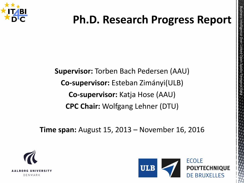
Supervisor: Torben Bach Pedersen (AAU)
Co-supervisor: Esteban Zimányi(ULB)
Co-supervisor: Katja Hose (AAU)
CPC Chair: Wolfgang Lehner (DTU)
Time span: August 15, 2013 – November 16, 2016
2
Bu
siness In
telligence O
ver Linked
Op
en Sp
atio-Te
mp
oral D
ata
1. Thesis Summary
2. Background
3. Objectives
4. Research Work
1. Completed Work
2. Ongoing Work
3. Future Work
5. Publications
6. Schedule
7. Ph.D. Courses
8. Discussion 3
Bu
siness In
telligence O
ver Linked
Op
en Sp
atio-Te
mp
oral D
ata
4
Bu
siness In
telligence O
ver Linked
Op
en Sp
atio-Te
mp
oral D
ata
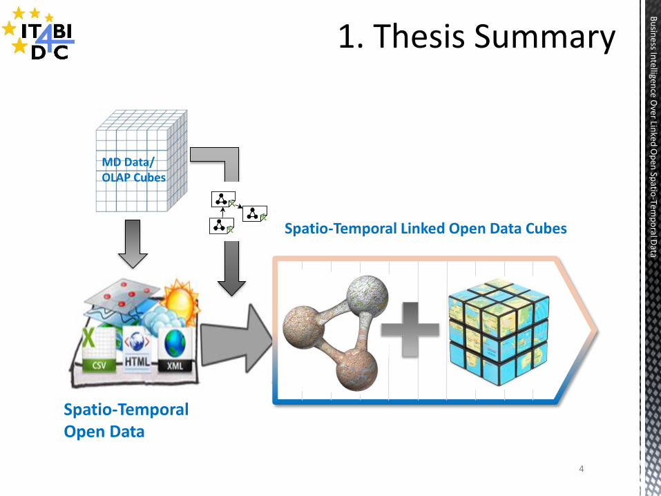
MD Data/ OLAP Cubes
Spatio-Temporal Linked Open Data Cubes
Spatio-Temporal Open Data
6
Bu
siness In
telligence O
ver Linked
Op
en Sp
atio-Te
mp
oral D
ata
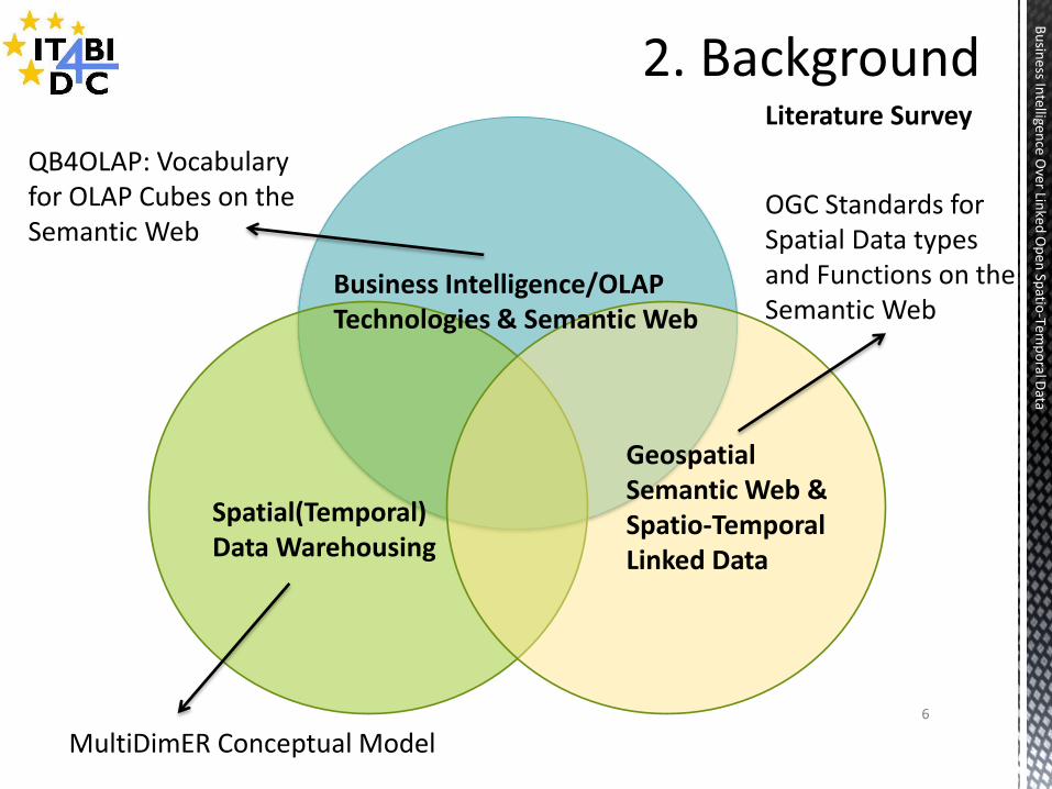
Literature Survey
Spatial(Temporal) Data Warehousing
Geospatial Semantic Web & Spatio-Temporal Linked Data
Business Intelligence/OLAP Technologies & Semantic Web
MultiDimER Conceptual Model
QB4OLAP: Vocabulary for OLAP Cubes on the Semantic Web
OGC Standards for Spatial Data types and Functions on the Semantic Web
7
Bu
siness In
telligence O
ver Linked
Op
en Sp
atio-Te
mp
oral D
ata
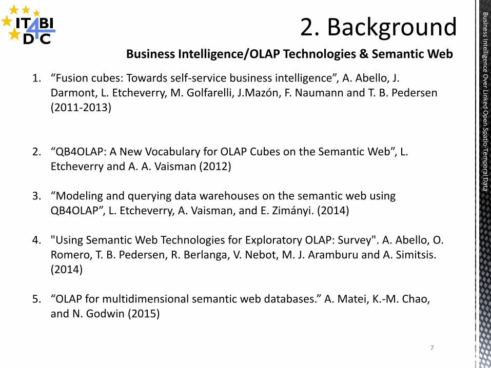
1. “Fusion cubes: Towards self-service business intelligence”, A. Abello, J.
Darmont, L. Etcheverry, M. Golfarelli, J.Mazón, F. Naumann and T. B. Pedersen (2011-2013)
2. “QB4OLAP: A New Vocabulary for OLAP Cubes on the Semantic Web”, L. Etcheverry and A. A. Vaisman (2012)
3. “Modeling and querying data warehouses on the semantic web using QB4OLAP”, L. Etcheverry, A. Vaisman, and E. Zimányi. (2014)
4. "Using Semantic Web Technologies for Exploratory OLAP: Survey". A. Abello, O. Romero, T. B. Pedersen, R. Berlanga, V. Nebot, M. J. Aramburu and A. Simitsis. (2014)
5. “OLAP for multidimensional semantic web databases.” A. Matei, K.-M. Chao, and N. Godwin (2015)
Business Intelligence/OLAP Technologies & Semantic Web
8
Bu
siness In
telligence O
ver Linked
Op
en Sp
atio-Te
mp
oral D
ata
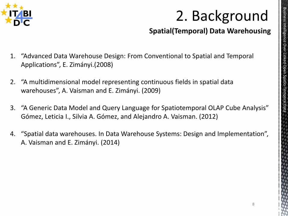
Spatial(Temporal) Data Warehousing
1. “Advanced Data Warehouse Design: From Conventional to Spatial and Temporal
Applications”, E. Zimányi.(2008)
2. “A multidimensional model representing continuous fields in spatial data warehouses”, A. Vaisman and E. Zimányi. (2009)
3. “A Generic Data Model and Query Language for Spatiotemporal OLAP Cube Analysis” Gómez, Leticia I., Silvia A. Gómez, and Alejandro A. Vaisman. (2012)
4. “Spatial data warehouses. In Data Warehouse Systems: Design and Implementation”, A. Vaisman and E. Zimányi. (2014)
9
Bu
siness In
telligence O
ver Linked
Op
en Sp
atio-Te
mp
oral D
ata
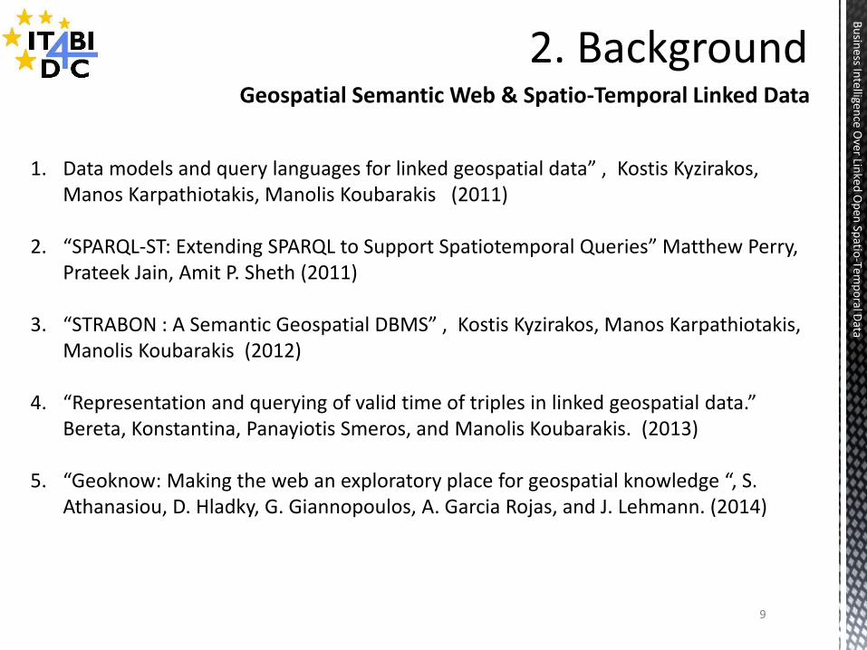
1. Data models and query languages for linked geospatial data” , Kostis Kyzirakos,
Manos Karpathiotakis, Manolis Koubarakis (2011)
2. “SPARQL-ST: Extending SPARQL to Support Spatiotemporal Queries” Matthew Perry, Prateek Jain, Amit P. Sheth (2011)
3. “STRABON : A Semantic Geospatial DBMS” , Kostis Kyzirakos, Manos Karpathiotakis, Manolis Koubarakis (2012)
4. “Representation and querying of valid time of triples in linked geospatial data.” Bereta, Konstantina, Panayiotis Smeros, and Manolis Koubarakis. (2013)
5. “Geoknow: Making the web an exploratory place for geospatial knowledge “, S. Athanasiou, D. Hladky, G. Giannopoulos, A. Garcia Rojas, and J. Lehmann. (2014)
Geospatial Semantic Web & Spatio-Temporal Linked Data

10
Bu
siness In
telligence O
ver Linked
Op
en Sp
atio-Te
mp
oral D
ata
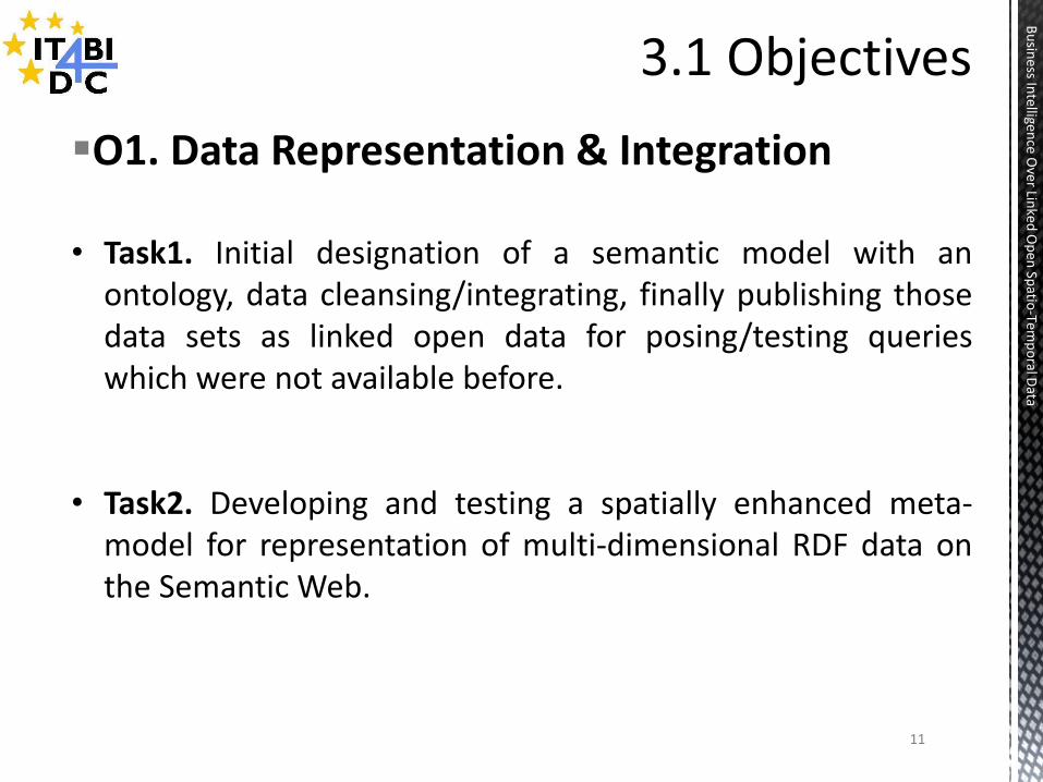
O1. Data Representation & Integration
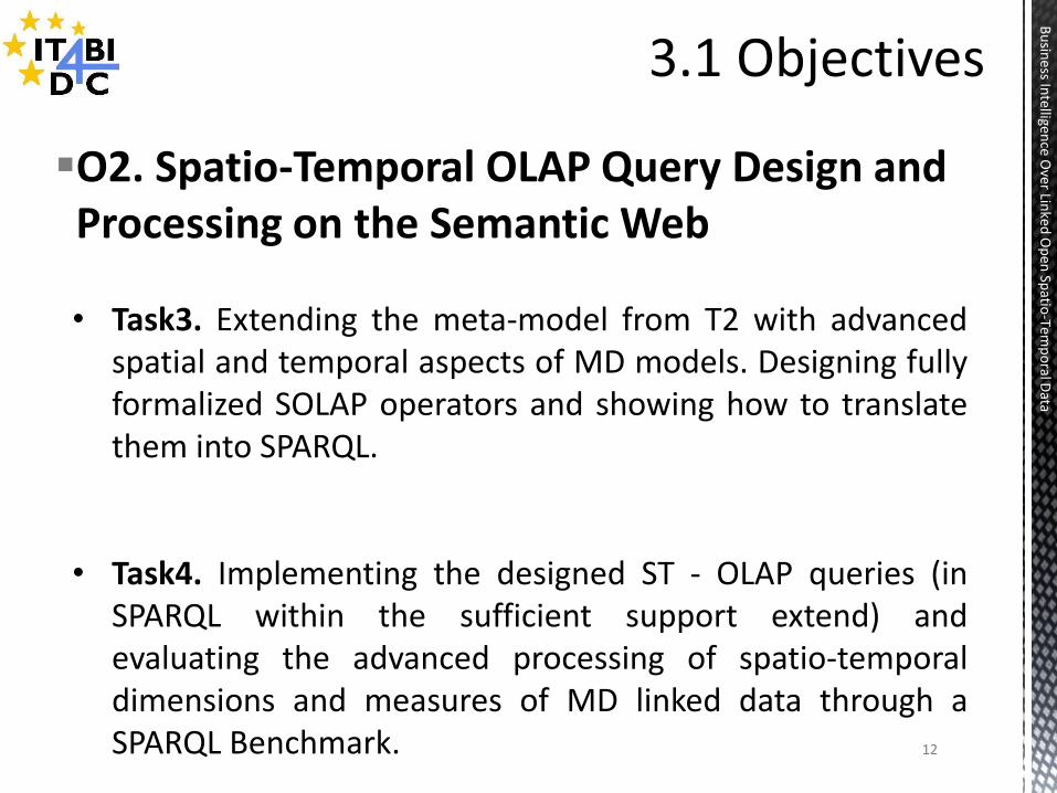
O2. Spatio-Temporal OLAP Query Design and Processing on the Semantic Web
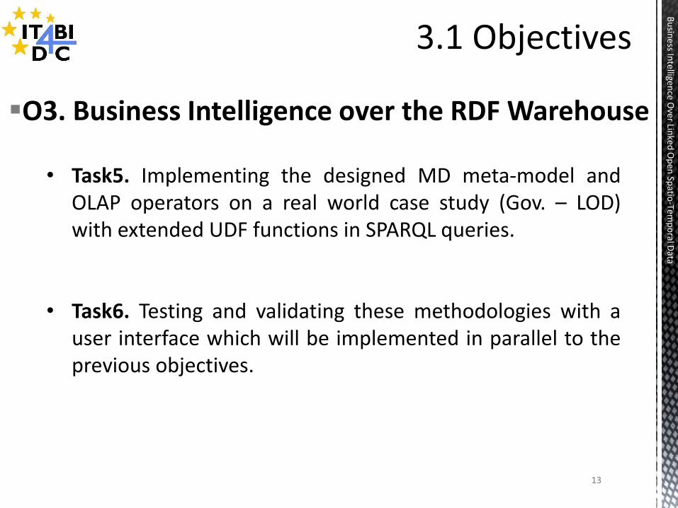
O3. Business Intelligence over the RDF Warehouse
11
Bu
siness In
telligence O
ver Linked
Op
en Sp
atio-Te
mp
oral D
ata
O1. Data Representation & Integration
• Task1. Initial designation of a semantic model with an
ontology, data cleansing/integrating, finally publishing those data sets as linked open data for posing/testing queries which were not available before.
• Task2. Developing and testing a spatially enhanced meta-model for representation of multi-dimensional RDF data on the Semantic Web.
12
Bu
siness In
telligence O
ver Linked
Op
en Sp
atio-Te
mp
oral D
ata
O2. Spatio-Temporal OLAP Query Design and Processing on the Semantic Web
• Task3. Extending the meta-model from T2 with advanced spatial and temporal aspects of MD models. Designing fully formalized SOLAP operators and showing how to translate them into SPARQL.
• Task4. Implementing the designed ST - OLAP queries (in SPARQL within the sufficient support extend) and evaluating the advanced processing of spatio-temporal dimensions and measures of MD linked data through a SPARQL Benchmark.
13
Bu
siness In
telligence O
ver Linked
Op
en Sp
atio-Te
mp
oral D
ata
O3. Business Intelligence over the RDF Warehouse
• Task5. Implementing the designed MD meta-model and OLAP operators on a real world case study (Gov. – LOD) with extended UDF functions in SPARQL queries.
• Task6. Testing and validating these methodologies with a user interface which will be implemented in parallel to the previous objectives.
14
Bu
siness In
telligence O
ver Linked
Op
en Sp
atio-Te
mp
oral D
ata
4.1 Completed Work (O1 & Partially O2) 4.2 Ongoing Work (O2) 4.3 Future Work (Partially O2 & O3)
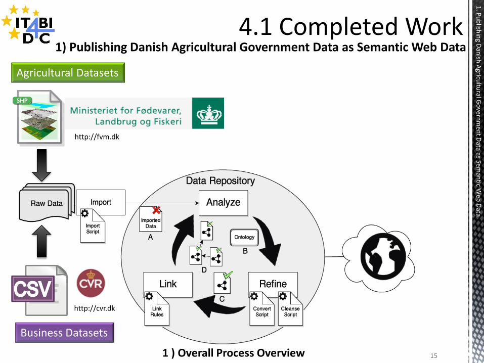
1) Publishing Danish Agricultural Government Data as Semantic Web Data
1 ) Overall Process Overview 15
Agricultural Datasets
Business Datasets
http://fvm.dk
http://cvr.dk
1. P
ub
lishin
g Dan
ish A
gricultu
ral Go
vern
men
t Data as Sem
antic W
eb D
ata
16
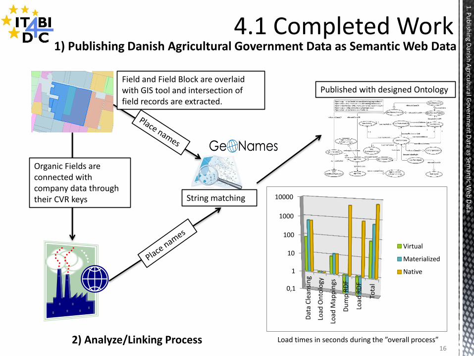
Organic Fields are connected with company data through their CVR keys String matching
0,1
1
10
100
1000
10000
Dat
a C
lean
sin
g
Load
On
tolo
gy
Load
Map
pin
gs
Du
mp
RD
F
Load
RD
F
Tota
l
Virtual
Materialized
Native
Published with designed Ontology
Load times in seconds during the ”overall process” 2) Analyze/Linking Process
1) Publishing Danish Agricultural Government Data as Semantic Web Data
1. P
ub
lishin
g Dan
ish A
gricultu
ral Go
vern
men
t Data as Sem
antic W
eb D
ata
Field and Field Block are overlaid with GIS tool and intersection of field records are extracted.
17
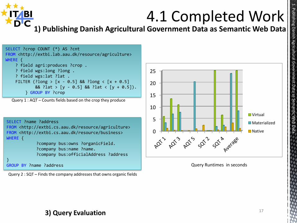
SELECT ?crop COUNT (*) AS ?cnt FROM <http://extbi.lab.aau.dk/resource/agriculture> WHERE { ? field agri:produces ?crop . ? field wgs:long ?long . ? field wgs:lat ?lat . FILTER (?long > [x - 0.5] && ?long < [x + 0.5] && ?lat > [y - 0.5] && ?lat < [y + 0.5]). } GROUP BY ?crop
SELECT ?name ?address FROM <http://extbi.cs.aau.dk/resource/agriculture> FROM <http://extbi.cs.aau.dk/resource/business> WHERE { ?company bus:owns ?organicField. ?company bus:name ?name. ?company bus:officialAddress ?address } GROUP BY ?name ?address
Query 2 : SQT – Finds the company addresses that owns organic fields
Query 1 : AQT – Counts fields based on the crop they produce
0
5
10
15
20
25
Virtual
Materialized
Native
Query Runtimes in seconds
3) Query Evaluation
1) Publishing Danish Agricultural Government Data as Semantic Web Data
1. P
ub
lishin
g Dan
ish A
gricultu
ral Go
vern
men
t Data as Sem
antic W
eb D
ata
18
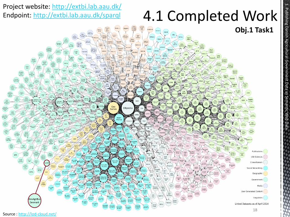
Project website: http://extbi.lab.aau.dk/ Endpoint: http://extbi.lab.aau.dk/sparql
Source : http://lod-cloud.net/
1. P
ub
lishin
g Dan
ish A
gricultu
ral Go
vern
men
t Data as Sem
antic W
eb D
ata
Obj.1 Task1
19
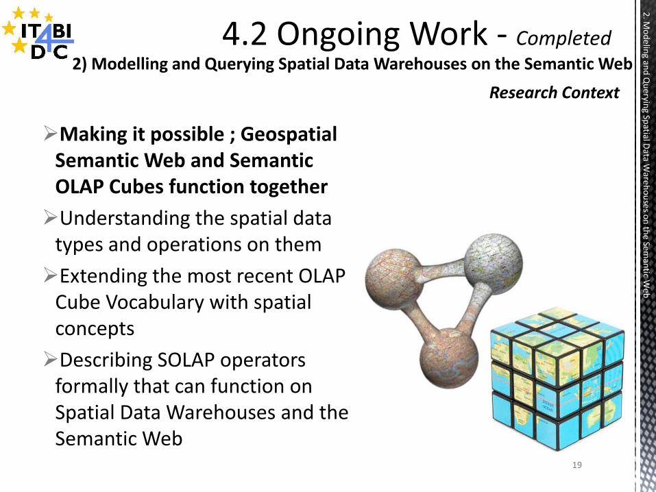
2) Modelling and Querying Spatial Data Warehouses on the Semantic Web
Research Context
2. M
od
eling an
d Q
ueryin
g Spatial D
ata Ware
ho
uses o
n th
e Seman
tic Web
Making it possible ; Geospatial Semantic Web and Semantic OLAP Cubes function together
Understanding the spatial data types and operations on them
Extending the most recent OLAP Cube Vocabulary with spatial concepts
Describing SOLAP operators formally that can function on Spatial Data Warehouses and the Semantic Web
20
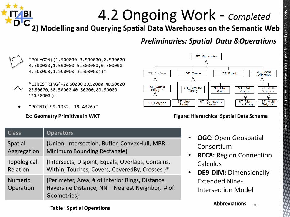
Class Operators
Spatial Aggregation
{Union, Intersection, Buffer, ConvexHull, MBR - Minimum Bounding Rectangle}
Topological Relation
{Intersects, Disjoint, Equals, Overlaps, Contains, Within, Touches, Covers, CoveredBy, Crosses }*
Numeric Operation
{Perimeter, Area, # of Interior Rings, Distance, Haversine Distance, NN – Nearest Neighbor, # of Geometries}
Preliminaries: Spatial Data &Operations
2) Modelling and Querying Spatial Data Warehouses on the Semantic Web
2. M
od
eling an
d Q
ueryin
g Spatial D
ata Ware
ho
uses o
n th
e Seman
tic Web
"POLYGON((1.500000 3.500000,2.500000 4.500000,1.500000 5.500000,0.500000 4.500000,1.500000 3.500000))"
"POINT(-99.1332 19.4326)"
“LINESTRING(-20.50000 20.50000, 40.50000 25.50000, 60.50000 40.50000, 80.50000 120.50000 )"
Ex: Geometry Primitives in WKT Figure: Hierarchical Spatial Data Schema
Table : Spatial Operations
• OGC: Open Geospatial Consortium
• RCC8: Region Connection Calculus
• DE9-DIM: Dimensionally Extended Nine-Intersection Model
Abbreviations
21
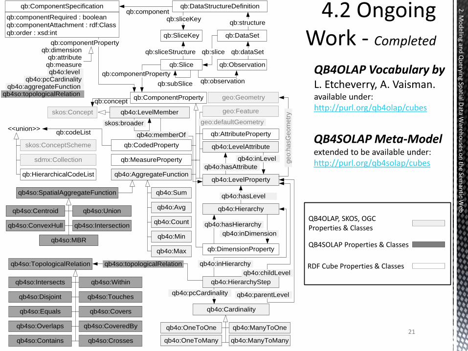
QB4SOLAP Meta-Model extended to be available under: http://purl.org/qb4solap/cubes
2. M
od
eling an
d Q
ueryin
g Spatial D
ata Ware
ho
uses o
n th
e Seman
tic Web
qb:ComponentProperty
qb:DimensionProperty
qb:AttributeProperty
qb:MeasureProperty
skos:ConceptScheme
qb:codeList
qb4o:AggregateFunctionqb4o:LevelProperty
qb4o:LevelMember
skos:broader
qb4o:Hierarchy
sdmx:Collection
qb:HierarchicalCodeList
<<union>>
qb:CodedProperty
qb4o:HierarchyStep
qb4o:hasLevel
qb4o:inDimension
qb4o:hasHierarchy
skos:Concept
qb:concept
qb:DataStructureDefinitionqb:ComponentSpecification
qb:componentRequired : boolean
qb:componentAttachment : rdf:Class
qb:order : xsd:int
qb:dimensionqb:attributeqb:measureqb4o:level
qb4o:pcCardinalityqb4o:aggregateFunction
qb:component
qb:componentProperty
qb:structureqb:sliceKey
qb:observation
qb:DataSet
qb:Slice qb:Observation
qb:SliceKey
qb:subSlice
qb:dataSetqb:sliceqb:sliceStructure
qb:componentProperty
qb4o:inHierarchy
qb4o:parentLevel
qb4o:childLevel
qb4so:SpatialAggregateFunction
qb4so:Union
qb4so:Intersectionqb4so:ConvexHull
qb4so:MBR
qb4so:Centroid
qb4o:Sum
qb4o:Avg
qb4o:Min
qb4o:Max
qb4o:Count
qb4so:TopologicalRelation
qb4so:Intersects
qb4so:Disjoint
qb4so:Equals
qb4so:Overlaps
qb4so:Within
qb4so:Touches
qb4so:Covers
qb4so:CoveredBy
qb4so:Contains qb4so:Crosses
qb4so:topologicalRelation
qb4o:pcCardinality
qb4o:OneToOne
qb4o:OneToMany
qb4o:ManyToOne
qb4o:ManyToMany
qb4o:Cardinality
geo:Geometryqb4so:topologicalRelation
ge
o:h
asG
eom
etr
y
qb4o:memberOf
qb4o:LevelAttribute
qb4o:hasAttribute
qb4o:inLevel
geo:Feature
geo:defaultGeometry
QB4OLAP Vocabulary by L. Etcheverry, A. Vaisman. available under: http://purl.org/qb4olap/cubes
QB4SOLAP Properties & Classes
RDF Cube Properties & Classes
QB4OLAP, SKOS, OGC Properties & Classes
qb:ComponentProperty
qb:DimensionProperty
qb:AttributeProperty
qb:MeasureProperty
skos:ConceptScheme
qb:codeList
qb4o:AggregateFunctionqb4o:LevelProperty
qb4o:LevelMember
skos:broader
qb4o:Hierarchy
sdmx:Collection
qb:HierarchicalCodeList
<<union>>
qb:CodedProperty
qb4o:HierarchyStep
qb4o:hasLevel
qb4o:inDimension
qb4o:hasHierarchy
skos:Concept
qb:concept
qb:DataStructureDefinitionqb:ComponentSpecification
qb:componentRequired : boolean
qb:componentAttachment : rdf:Class
qb:order : xsd:int
qb:dimensionqb:attributeqb:measureqb4o:level
qb4o:pcCardinalityqb4o:aggregateFunction
qb:component
qb:componentProperty
qb:structureqb:sliceKey
qb:observation
qb:DataSet
qb:Slice qb:Observation
qb:SliceKey
qb:subSlice
qb:dataSetqb:sliceqb:sliceStructure
qb:componentProperty
qb4o:inHierarchy
qb4o:parentLevel
qb4o:childLevel
qb4so:SpatialAggregateFunction
qb4so:Union
qb4so:Intersectionqb4so:ConvexHull
qb4so:MBR
qb4so:Centroid
qb4o:Sum
qb4o:Avg
qb4o:Min
qb4o:Max
qb4o:Count
qb4so:TopologicalRelation
qb4so:Intersects
qb4so:Disjoint
qb4so:Equals
qb4so:Overlaps
qb4so:Within
qb4so:Touches
qb4so:Covers
qb4so:CoveredBy
qb4so:Contains qb4so:Crosses
qb4so:topologicalRelation
qb4o:pcCardinality
qb4o:OneToOne
qb4o:OneToMany
qb4o:ManyToOne
qb4o:ManyToMany
qb4o:Cardinality
geo:Geometryqb4so:topologicalRelation
ge
o:h
asG
eom
etr
y
qb4o:memberOf
qb4o:LevelAttribute
qb4o:hasAttribute
qb4o:inLevel
geo:Feature
geo:defaultGeometry
22
2. M
od
eling an
d Q
ueryin
g Spatial D
ata Ware
ho
uses o
n th
e Seman
tic Web
23
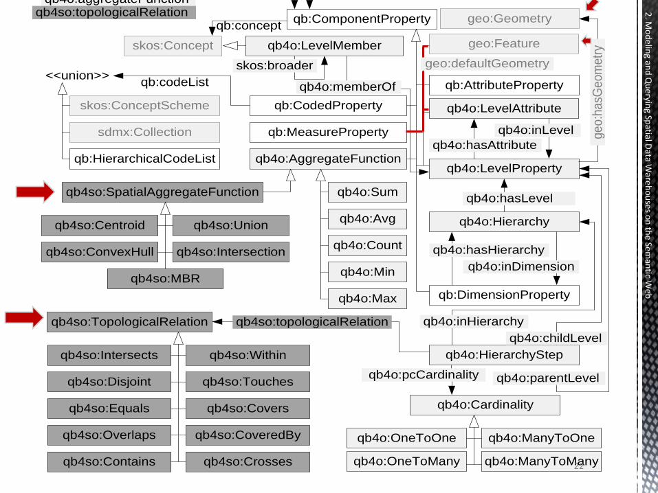
Spatial Data Warehouse Members in QB4SOLAP
2. M
od
eling an
d Q
ueryin
g Spatial D
ata Ware
ho
uses o
n th
e Seman
tic Web
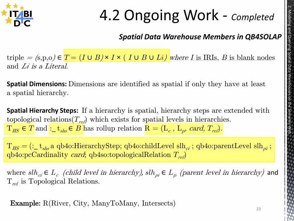
triple = (s,p,o) ∈ T = (I ∪ B) × I × ( I ∪ B ∪ Li) where I is IRIs, B is blank nodes
and Li is a Literal.
Spatial Dimensions: Dimensions are identified as spatial if only they have at least
a spatial hierarchy.
Spatial Hierarchy Steps: If a hierarchy is spatial, hierarchy steps are extended with
topological relations(Trel) which exists for spatial levels in hierarchies. THS ∈ T and :_ tshs ∈ B has rollup relation R = (Lc , Lp, card, Trel).
THS = (:_ tshs a qb4o:HierarchyStep; qb4o:childLevel slhci ; qb4o:parentLevel slhpi ;
qb4o:pcCardinality card; qb4so:topologicalRelation Trel)
where slhci ∈ Lc (child level in hierarchy), slhpi ∈ Lp (parent level in hierarchy) and Trel is Topological Relations.
Example: R(River, City, ManyToMany, Intersects)
24
Spatial Data Warehouse Members in QB4SOLAP
2. M
od
eling an
d Q
ueryin
g Spatial D
ata Ware
ho
uses o
n th
e Seman
tic Web
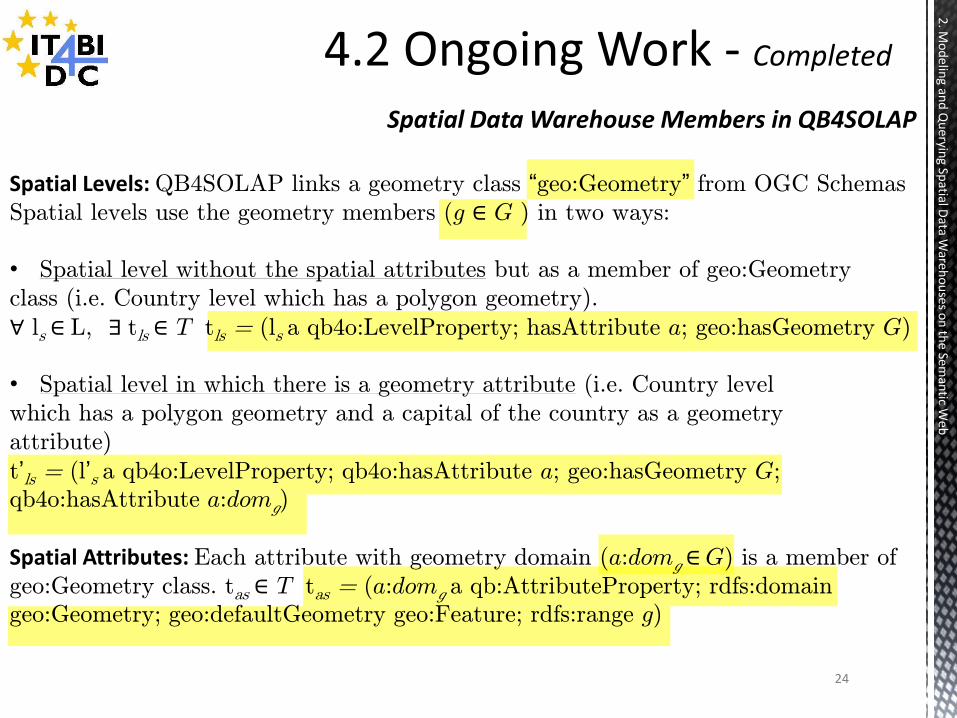
Spatial Levels: QB4SOLAP links a geometry class “geo:Geometry” from OGC Schemas
Spatial levels use the geometry members (g ∈ G ) in two ways:
• Spatial level without the spatial attributes but as a member of geo:Geometry
class (i.e. Country level which has a polygon geometry).
∀ ls ∈ L, ∃ tls ∈ T tls = (ls a qb4o:LevelProperty; hasAttribute a; geo:hasGeometry G)
• Spatial level in which there is a geometry attribute (i.e. Country level
which has a polygon geometry and a capital of the country as a geometry
attribute)
t’ls = (l’s a qb4o:LevelProperty; qb4o:hasAttribute a; geo:hasGeometry G;
qb4o:hasAttribute a:domg)
Spatial Attributes: Each attribute with geometry domain (a:domg ∈ G) is a member of
geo:Geometry class. tas ∈ T tas = (a:domg a qb:AttributeProperty; rdfs:domain
geo:Geometry; geo:defaultGeometry geo:Feature; rdfs:range g)

25
Spatial Data Warehouse Members in QB4SOLAP
2. M
od
eling an
d Q
ueryin
g Spatial D
ata Ware
ho
uses o
n th
e Seman
tic Web
Spatial Measures: QB4SOLAP allows spatial measures in the cube, represented by a
geometry thus they use a different schema than conventional (numeric) measures
which is from OGC schemas. Spatial measures also require the specification of spatial
aggregation functions(Sagg).
tms ∈ T tms= (ms a qb:MeasureProperty; rdfs:subPropertyOf sdmx-measure:obsValue;
geo:defaulyGeometry geo:Feature)
The class of the measure value is given with the property rdfs:domain and rdfs:range
says what values each property can take such as; point, polygon, line etc.
Spatial Facts: Fs relates several levels of which two or more are spatial(ls). Ideally a
spatial fact cube has also spatial measures (ms) mentioned above.
tfs = (Fs a qb:DataStructureDefiniton; qb:component[qb4o:level ls ;
rdfs:subPropertyOf sdmx-dimension:refArea; qb4o:cardinality card ;
qb4so:topologicalRelation Trel ]; qb:component[qb:measure ms ;
qb4o:aggregateFunction Sagg ] ).
26
2. M
od
eling an
d Q
ueryin
g Spatial D
ata Ware
ho
uses o
n th
e Seman
tic Web
Spatial OLAP Operators
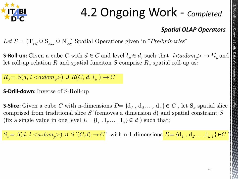
Let S = (Trel ∪ Sagg ∪ Nop) Spatial Operations given in “Preliminaries”
S-Roll-up: Given a cube C with d ∈ C and level lu ∈ d, such that l<a:domg> → *lu and
let roll-up relation R and spatial funciton S comprise Rs spatial roll-up as:
Rs = S(d, l <a:domg>) ∪ R(C, d, lu ) → C ’
S-Drill-down: Inverse of S-Roll-up
S-Slice: Given a cube C with n-dimensions D= {d1 , d2 … , dn } ∈ C , let Ss spatial slice
comprised from traditional slice S ’(removes a dimension d) and spatial constraint S
(fix a single value in one level L= {l1 , l2 … , ln } ∈ d ) such that;
Ss = S(d, l <a:domg>) ∪ S ’(C,d) → C ’ with n-1 dimensions D= {d1 , d2 … ,dn-1 } ∈C ’
27
2. M
od
eling an
d Q
ueryin
g Spatial D
ata Ware
ho
uses o
n th
e Seman
tic Web
Spatial OLAP Operators
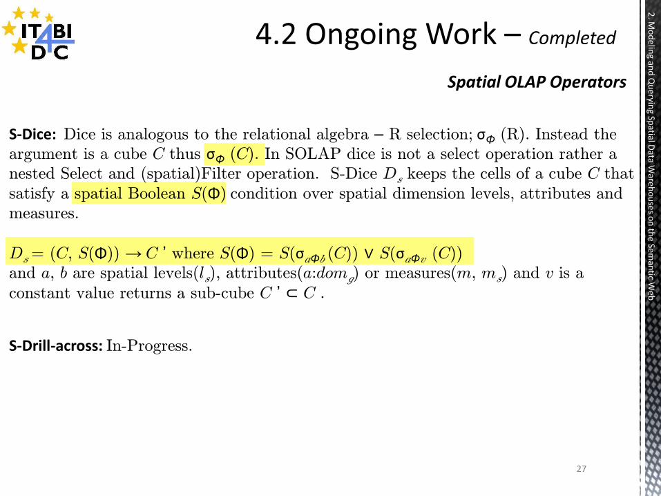
S-Dice: Dice is analogous to the relational algebra – R selection; σΦ (R). Instead the
argument is a cube C thus σΦ (C). In SOLAP dice is not a select operation rather a
nested Select and (spatial)Filter operation. S-Dice Ds keeps the cells of a cube C that
satisfy a spatial Boolean S(Φ) condition over spatial dimension levels, attributes and
measures.
Ds = (C, S(Φ)) → C ’ where S(Φ) = S(σaΦb (C)) ∨ S(σaΦv (C))
and a, b are spatial levels(ls), attributes(a:domg) or measures(m, ms) and v is a
constant value returns a sub-cube C ’ ⊂ C .
S-Drill-across: In-Progress.
28
2. M
od
eling an
d Q
ueryin
g Spatial D
ata Ware
ho
uses o
n th
e Seman
tic Web
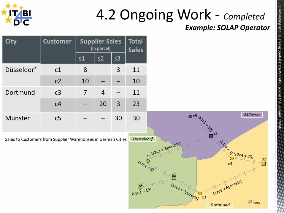
Example: SOLAP Operator
City Customer Supplier Sales (in parcel)
Total Sales
s1 s2 s3
Düsseldorf c1 8 – 3 11
c2 10 – – 10
Dortmund c3 7 4 – 11
c4 – 20 3 23
Münster c5 – – 30 30
Sales to Customers from Supplier Warehouses in German Cities
29
2. M
od
eling an
d Q
ueryin
g Spatial D
ata Ware
ho
uses o
n th
e Seman
tic Web
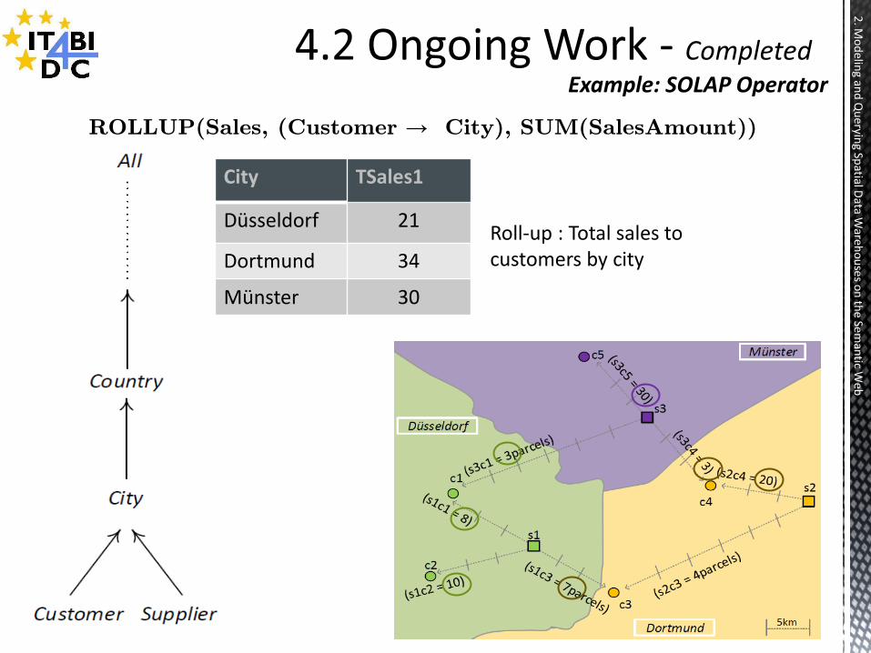
Roll-up : Total sales to customers by city
City TSales1
Düsseldorf 21
Dortmund 34
Münster 30
Example: SOLAP Operator
ROLLUP(Sales, (Customer → City), SUM(SalesAmount))
30
2. M
od
eling an
d Q
ueryin
g Spatial D
ata Ware
ho
uses o
n th
e Seman
tic Web
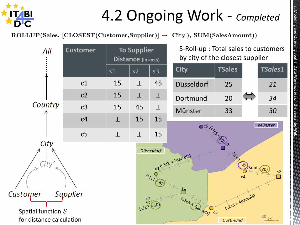
Customer To Supplier Distance (in km.s)
s1 s2 s3
c1 15 ⊥ 45
c2 15 ⊥ ⊥
c3 15 45 ⊥
c4 ⊥ 15 15
c5 ⊥ ⊥ 15
S-Roll-up : Total sales to customers by city of the closest supplier
City TSales
Düsseldorf 25
Dortmund 20
Münster 33
TSales1
21
34
30
Spatial function S
for distance calculation
ROLLUP(Sales, [CLOSEST(Customer,Supplier)] → City’), SUM(SalesAmount))
31
2. M
od
eling an
d Q
ueryin
g Spatial D
ata Ware
ho
uses o
n th
e Seman
tic Web
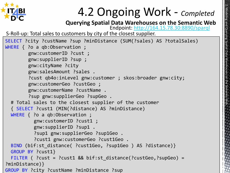
Querying Spatial Data Warehouses on the Semantic Web
SELECT ?city ?custName ?sup ?minDistance (SUM(?sales) AS ?totalSales) WHERE { ?o a qb:Observation ; gnw:customerID ?cust ; gnw:supplierID ?sup ; gnw:cityName ?city gnw:salesAmount ?sales . ?cust qb4o:inLevel gnw:customer ; skos:broader gnw:city; gnw:customerGeo ?custGeo ; gnw:customerName ?custName . ?sup gnw:supplierGeo ?supGeo . # Total sales to the closest supplier of the customer { SELECT ?cust1 (MIN(?distance) AS ?minDistance) WHERE { ?o a qb:Observation ; gnw:customerID ?cust1 ; gnw:supplierID ?sup1 . ?sup1 gnw:supplierGeo ?sup1Geo . ?cust1 gnw:customerGeo ?cust1Geo . BIND (bif:st_distance( ?cust1Geo, ?sup1Geo ) AS ?distance)} GROUP BY ?cust1} FILTER ( ?cust = ?cust1 && bif:st_distance(?custGeo,?supGeo) = ?minDistance)} GROUP BY ?city ?custName ?minDistance ?sup
Endpoint: http://164.15.78.30:8890/sparql S-Roll-up: Total sales to customers by city of the closest supplier.

32
2. M
od
eling an
d Q
ueryin
g Spatial D
ata Ware
ho
uses o
n th
e Seman
tic Web
Querying Spatial Data Warehouses on the Semantic Web
SELECT ?custName ?distance (SUM(?sales) AS ?totalSales) WHERE { ?o a qb:Observation ; gnw:customerID ?cust ; gnw:supplierID ?sup ; gnw:salesAmount ?sales . ?cust gnw:companyName ?custName ; gnw:customerGeo ?custGeo . ?sup gnw:supplierGeo ?supGeo . BIND (bif:st_distance (?custGeo, ?supGeo) AS ?distance) FILTER ( ?distance < 200 ) } GROUP BY ?custName ?distance ORDER BY ?custName
Endpoint: http://164.15.78.30:8890/sparql
S-Dice: Total sales amount to the customers that have orders delivered by suppliers such that their locations are less than 200 km from each other.
33
2. M
od
eling an
d Q
ueryin
g Spatial D
ata Ware
ho
uses o
n th
e Seman
tic Web
Querying Spatial Data Warehouses on the Semantic Web
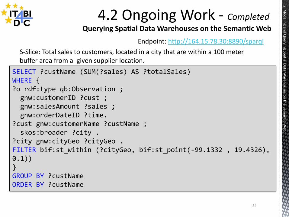
SELECT ?custName (SUM(?sales) AS ?totalSales) WHERE { ?o rdf:type qb:Observation ; gnw:customerID ?cust ; gnw:salesAmount ?sales ; gnw:orderDateID ?time. ?cust gnw:customerName ?custName ; skos:broader ?city . ?city gnw:cityGeo ?cityGeo . FILTER bif:st_within (?cityGeo, bif:st_point(-99.1332 , 19.4326), 0.1)) } GROUP BY ?custName ORDER BY ?custName
Endpoint: http://164.15.78.30:8890/sparql S-Slice: Total sales to customers, located in a city that are within a 100 meter
buffer area from a given supplier location.
34
Mo
delin
g and
Qu
erying Sp
atial Data W
areh
ou
ses on
the Sem
antic W
eb
2) Modelling and Querying Spatial Data Warehouses on the Semantic Web
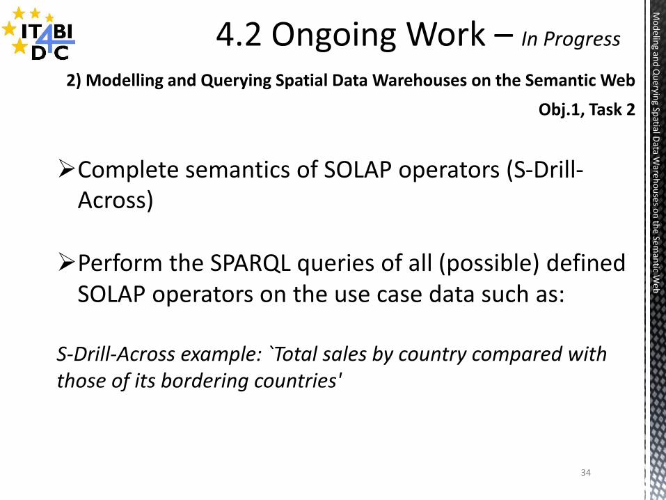
Complete semantics of SOLAP operators (S-Drill-Across)
Perform the SPARQL queries of all (possible) defined
SOLAP operators on the use case data such as: S-Drill-Across example: `Total sales by country compared with those of its bordering countries'
Obj.1, Task 2
35
3. A
Gen
eric Data M
od
el for Sp
atio-Te
mp
oral O
LAP
Cu
bes o
n th
e Seman
tic Web
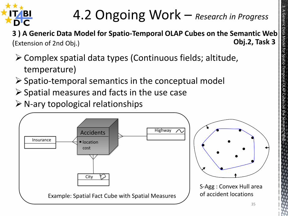
3 ) A Generic Data Model for Spatio-Temporal OLAP Cubes on the Semantic Web (Extension of 2nd Obj.) Obj.2, Task 3
Complex spatial data types (Continuous fields; altitude, temperature)
Spatio-temporal semantics in the conceptual model Spatial measures and facts in the use case N-ary topological relationships
Accidents
location cost
City
Highway
Insurance
Example: Spatial Fact Cube with Spatial Measures
S-Agg : Convex Hull area of accident locations

36
Bu
siness In
telligence O
ver Linked
Op
en Sp
atio-Te
mp
oral D
ata
Obj2. Task 4
4) Query Processing for Spatio-Temporal Linked Data in RDF Warehouses (Implementation of 3rd task to an extent + Performance Evaluation)
Create a Spatio-Temporal SPARQL Benchmark From: Available open benchmark data i.e.BerlinMOD (Berlin Moving Object Database) Use latest version of QB4SOLAP meta-model Criterias: Comparison of STDBMS with ST SPARQL Benchmark Evaluation of QB4SOLAP queries in SPARQL
37
Bu
siness In
telligence O
ver Linked
Op
en Sp
atio-Te
mp
oral D
ata
Obj.3 Task 5 & 6
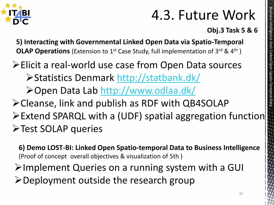
5) Interacting with Governmental Linked Open Data via Spatio-Temporal OLAP Operations (Extension to 1st Case Study, full implementation of 3rd & 4th )
6) Demo LOST-BI: Linked Open Spatio-temporal Data to Business Intelligence (Proof of concept overall objectives & visualization of 5th )
Elicit a real-world use case from Open Data sources Statistics Denmark http://statbank.dk/ Open Data Lab http://www.odlaa.dk/
Cleanse, link and publish as RDF with QB4SOLAP Extend SPARQL with a (UDF) spatial aggregation function Test SOLAP queries
Implement Queries on a running system with a GUI Deployment outside the research group
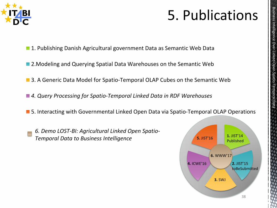
1. Publishing Danish Agricultural government Data as Semantic Web Data
2.Modeling and Querying Spatial Data Warehouses on the Semantic Web
3. A Generic Data Model for Spatio-Temporal OLAP Cubes on the Semantic Web
4. Query Processing for Spatio-Temporal Linked Data in RDF Warehouses
5. Interacting with Governmental Linked Open Data via Spatio-Temporal OLAP Operations
1. JIST’14 Published
2. JIST’15 toBeSubmitted
4. ICWE’16
3. SWJ
5. JIST’16
6. WWW’17
6. Demo LOST-BI: Agricultural Linked Open Spatio-Temporal Data to Business Intelligence
38
Bu
siness In
telligence O
ver Linked
Op
en Sp
atio-Te
mp
oral D
ata
39
Bu
siness In
telligence O
ver Linked
Op
en Sp
atio-Te
mp
oral D
ata
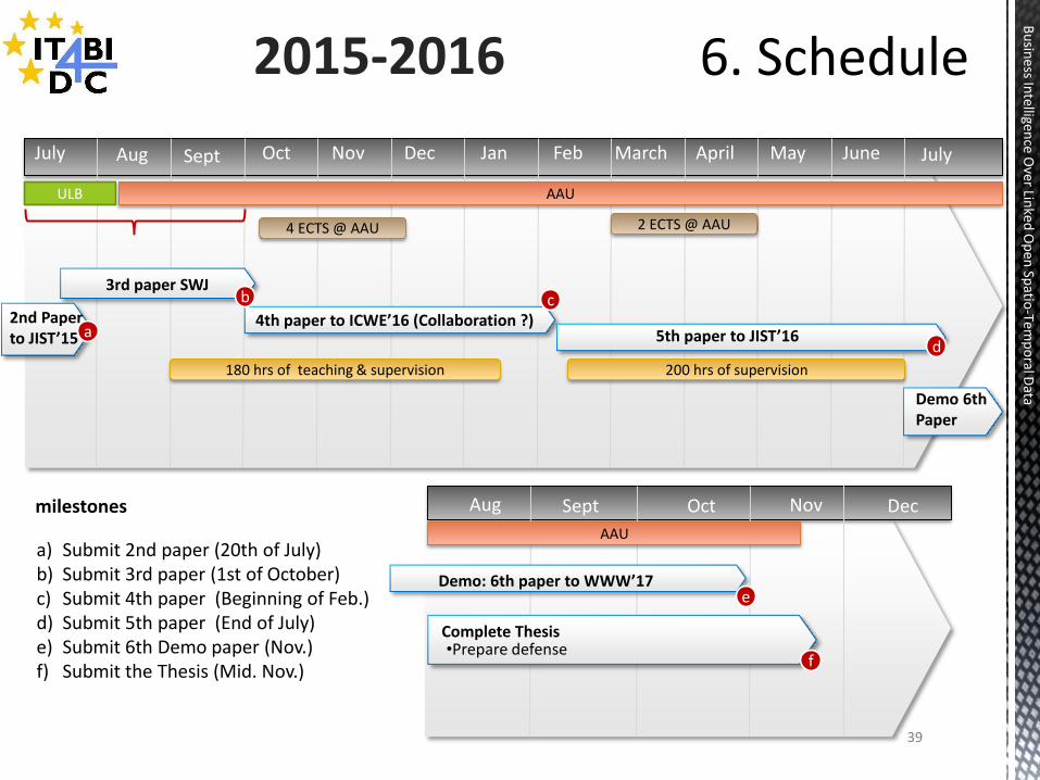
2015-2016
3rd paper SWJ
June April March Feb Jan Dec Oct Sept July Nov May
AAU
2nd Paper to JIST’15
milestones
a) Submit 2nd paper (20th of July) b) Submit 3rd paper (1st of October) c) Submit 4th paper (Beginning of Feb.) d) Submit 5th paper (End of July) e) Submit 6th Demo paper (Nov.) f) Submit the Thesis (Mid. Nov.)
July
4th paper to ICWE’16 (Collaboration ?)
200 hrs of supervision 180 hrs of teaching & supervision
Aug
ULB
a
b
4 ECTS @ AAU 2 ECTS @ AAU
c
5th paper to JIST’16 d
Demo 6th Paper
Aug Oct Sept Nov Dec
AAU
•Prepare defense Complete Thesis
Demo: 6th paper to WWW’17 e
f
40
Bu
siness In
telligence O
ver Linked
Op
en Sp
atio-Te
mp
oral D
ata
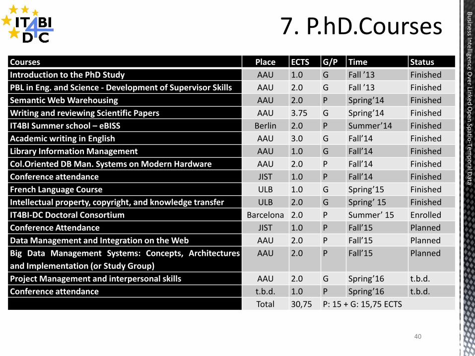
Courses Place ECTS G/P Time Status
Introduction to the PhD Study AAU 1.0 G Fall ’13 Finished
PBL in Eng. and Science - Development of Supervisor Skills AAU 2.0 G Fall ’13 Finished
Semantic Web Warehousing AAU 2.0 P Spring’14 Finished
Writing and reviewing Scientific Papers AAU 3.75 G Spring’14 Finished
IT4BI Summer school – eBISS Berlin 2.0 P Summer’14 Finished
Academic writing in English AAU 3.0 G Fall’14 Finished
Library Information Management AAU 1.0 G Fall’14 Finished
Col.Oriented DB Man. Systems on Modern Hardware AAU 2.0 P Fall’14 Finished
Conference attendance JIST 1.0 P Fall’14 Finished
French Language Course ULB 1.0 G Spring’15 Finished
Intellectual property, copyright, and knowledge transfer ULB 2.0 G Spring’ 15 Finished
IT4BI-DC Doctoral Consortium Barcelona 2.0 P Summer’ 15 Enrolled
Conference Attendance JIST 1.0 P Fall’15 Planned
Data Management and Integration on the Web AAU 2.0 P Fall’15 Planned
Big Data Management Systems: Concepts, Architectures
and Implementation (or Study Group)
AAU 2.0 P Fall’15 Planned
Project Management and interpersonal skills AAU 2.0 G Spring’16 t.b.d.
Conference attendance t.b.d. 1.0 P Spring’16 t.b.d.
Total 30,75 P: 15 + G: 15,75 ECTS
Thank you for your attention
41
Bu
siness In
telligence O
ver Linked
Op
en Sp
atio-Te
mp
oral D
ata
This Project is funded by EM – Erasmus Mundus with an addition to fund from AAU – Aalborg University.