business paper - ordinary meeting agenda - 31 may 2016...may 31, 2016 · meeting date: 31 may 2016...
TRANSCRIPT

ORDINARY MEETING
Meeting Date: 31 May 2016
Item: 96 CP - Planning Proposal to Amend Hawkesbury Local Environmental Plan 2012 - 452 Greggs Road, Kurrajong - (95498, 124414)
Applicant Name: Glenn Falson Urban and Rural Planning Consultant Planning Proposal No: LEP004/16 Property Address: 452 Greggs Road, Kurrajong Owner/s: NS Hatherly Date Received: 3 February 2016 Current Minimum Lot Size: 10 Hectares Proposed Minimum Lot Size: 4,000m2
Current Zone: RU1 Primary Production Site Area: 8,359m2 Recommendation: Council support the preparation of a planning proposal to enable the
subdivision of the subject site into large residential lots with a minimum lot size of not less than 4,000m2.
REPORT:
Executive Summary Council has received a planning proposal from Glenn Falson Urban and Rural Planning Consultant (the applicant) which seeks to amend the Hawkesbury Local Environmental Plan 2012 (the LEP) to enable potential subdivision of Lot E DP 373372, 452 Greggs Road, Kurrajong (the subject site) into two large residential lots with a minimum lot size of not less than 4,000m2. This report provides Council with an overview of the planning proposal and recommends that the planning proposal be supported and submitted to the Department of Planning and Environment (DP&E) for a ‘Gateway’ determination. Consultation The planning proposal has not yet been exhibited as Council has not resolved to prepare the proposal. If the planning proposal is to proceed it will be exhibited in accordance with the relevant provisions of the Environmental Planning and Assessment Act, 1979 (EP&A Act) and associated Regulations, and as specified in the 'Gateway' determination. Planning Proposal The planning proposal seeks an amendment to the LEP in order to permit the subdivision of the site into two lots with a minimum lot size of not less than 4,000m2. The planning proposal aims to achieve the above proposed outcome by amending the Minimum Lot Size Map (Map Identification No. 3800_COM_LSZ_008A_040_20150707) of the LEP alone or amending both the Lot Size Map and the Land Zoning Map of the LEP. The applicant presumes that Council will insert an appropriate provision in the LEP to limit the maximum lot yield of the subdivision of the site consistent with the planning proposal to allow the site to be subdivided into two large residential lots. A concept plan for the proposed two lot subdivision is attached to the planning proposal, which is for discussion purposes only in relation to the potential yield of the site, and does not form part of the planning proposal. This concept plan shows two large residential lots that are identified as Proposed Lots 11 and 12 with each containing an existing dwelling.
ORDINARY SECTION 3 Page 127
ORDINARY MEETING
Meeting Date: 31 May 2016
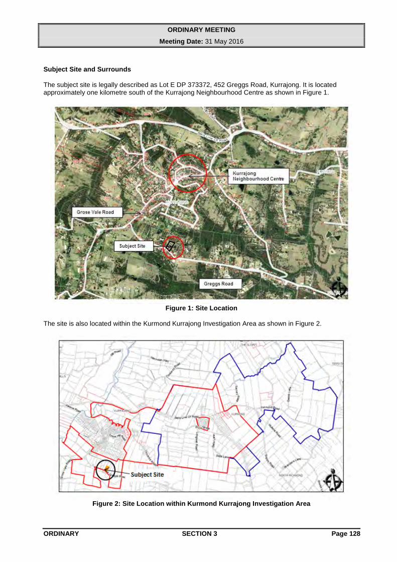
Subject Site and Surrounds The subject site is legally described as Lot E DP 373372, 452 Greggs Road, Kurrajong. It is located approximately one kilometre south of the Kurrajong Neighbourhood Centre as shown in Figure 1.
Figure 1: Site Location
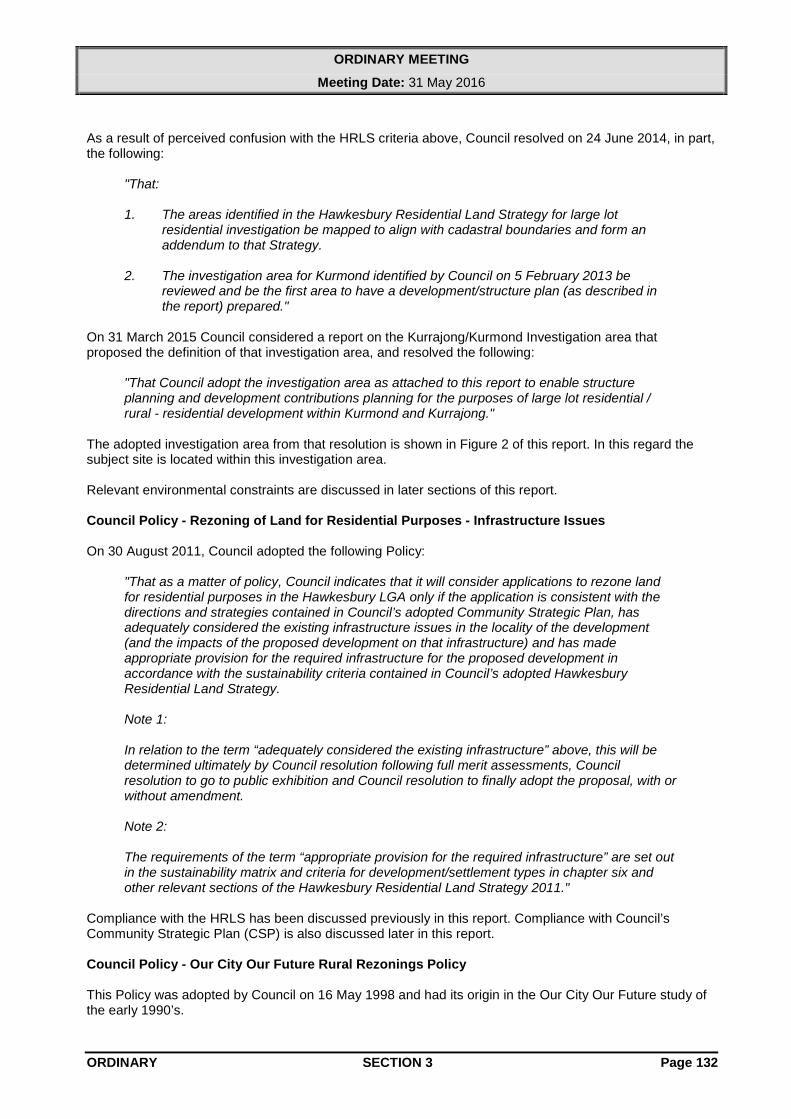
The site is also located within the Kurmond Kurrajong Investigation Area as shown in Figure 2.
Figure 2: Site Location within Kurmond Kurrajong Investigation Area
ORDINARY SECTION 3 Page 128

ORDINARY MEETING
Meeting Date: 31 May 2016
The subject site has an area of 8,359m2 and is almost a trapezium in shape with an approximate frontage of 70m to Greggs Road as shown in Figure 3 below.
Figure 3: Subject Site
The subject site is currently accessed via Greggs Road which is connected to Grose Vale Road. The subject site is currently zoned RU1 Primary Production under the LEP. The current minimum lot size for subdivision of this land is 10ha. The subject site is shown as being bushfire prone (Bushfire Vegetation Category 1) on the NSW Rural Fire Service’s Bushfire Prone Land Map. The whole subject site is shown as being within Class 5 Acid Sulfate Soils on the Acid Sulphate Soils Planning Maps contained within the LEP. Acid Sulfate Soil Classification 5 represents a relatively low chance of acid sulphate soils being present on the site. The subject site is shown as being Agriculture Land Classification 3 on maps prepared by the former NSW Department of Agriculture. The subject site contains two dwellings and two outbuildings. According to the applicant one of the dwellings is approximately 90 years old with historical significance. The old dwelling has been used as a studio and for storage purposes associated with use of the new dwelling. When a new dwelling was approved ten years ago there was a condition imposed requiring the conversion of the old house uninhabitable and use for storage purposes. The subject site is situated well above the 1 in 100 year ARI flood level. The subject site has been identified as having ‘connectivity between remnant vegetation and endangered ecological community’ on the Terrestrial Biodiversity Map. Existing vegetation on the subject site is predominantly located along the site boundaries and between the two existing dwellings.
ORDINARY SECTION 3 Page 129

ORDINARY MEETING
Meeting Date: 31 May 2016
The subject site falls within the Colo River Catchment Area of Sydney Regional Environmental Plan No.20 Hawkesbury - Nepean River (No.2 - 1997). Based on Council’s slope mapping, the entire site area, other than a small area of land near the middle of the north-eastern boundary and the north-western corner has a slope less than 15%. Properties in the immediate vicinity of the subject site are zoned RU1 Primary Production under the LEP. The immediate locality is predominantly zoned RU1 Primary Production. The current minimum lot sizes applicable for the subdivision of the surrounding properties are generally in the range of 450m2 to 10ha. The immediate locality is characterised by a mix of lot sizes with varying frontages, shapes and areas. Smaller lots are located immediately opposite and adjacent in Grose Vale Road, and to the north in Robertson Street. Larger lots are generally located to the east and further south. The immediate surrounding area of the site is predominantly characterised by rural residential development. Applicant’s Justification of Proposal The applicant has provided the following justification for the planning proposal: • The proposed subdivision is consistent with the Hawkesbury Residential Land Strategy
(HRLS). • The site has the necessary attributes for large lot residential development consistent with the
findings of the HRLS. • The subject site is located within the Kurmond/Kurrajong Investigation Area and is included in
an investigation area map prepared by Council. • The preliminary site investigations reveal that the site is capable of subdivision into two lots
that would be consistent with other lands in the vicinity, and would form an appropriate component of village expansion at Kurrajong.
• The proposed lot sizes are capable of containing an on-site wastewater disposal system and matters relating to vegetation and bushfire management.
• Water, electricity, telephone, garbage and recycling facilities are currently available to the site. ‘A Plan for Growing Sydney’ (the Sydney Metropolitan Strategy), Draft North West Subregional Strategy and Hawkesbury Residential Land Strategy The NSW Government’s ‘A Plan for Growing Sydney’ December 2014 (the Sydney Metropolitan Strategy) and Draft North West Subregional Strategy establish the broad planning directions for the Sydney metropolitan area and north-western sector of Sydney respectively. These documents identify a number of strategies, objectives and actions relating to the economy and employment, centres and corridors, housing, transport, environment and resources, parks and public places, implementation and governance. These two documents have a high level metropolitan and regional focus and for the most part are not readily applicable to a singular rural residential planning proposal at Kurrajong. Notwithstanding this the applicant has provided an assessment of the planning proposal against these two documents and concludes that the proposal is consistent with these strategies. Given the location of the proposed development, i.e. on the western side of Hawkesbury River, and on the fringe of the Kurrajong Neighbourhood Centre, and the unsuitability of the development of the site for increased residential densities it is considered that the proposal demonstrates satisfactory compliance with these strategies. The Hawkesbury Residential Land Strategy (HRLS) is in part a response to the above mentioned State strategies and seeks to identify residential investigation areas and sustainable development criteria which are consistent with the NSW Government’s strategies.
ORDINARY SECTION 3 Page 130

ORDINARY MEETING
Meeting Date: 31 May 2016
The HRLS contains the following commentary and criteria regarding large lot residential / rural residential development:
“2.10 Strategy for Rural Village Development
The Hawkesbury Residential Development Model focuses on future residential development in urban areas and key centres. However, the importance of maintaining the viability of existing rural villages is recognised. As such, the Hawkesbury Residential Strategy has developed a strategy for rural residential development.
Future development in rural villages should be of low density and large lot dwellings, which focus on proximity to centres and services and facilities. Rural village development should also minimise impacts on agricultural land, protect scenic landscape and natural areas, and occur within servicing limits or constraints.”
The planning proposal can be considered as a rural residential development on the fringe of the Kurrajong Neighbourhood Centre. The HRLS states that the future role of rural residential development is as follows:
Rural residential developments have historically been a popular lifestyle choice within Hawkesbury LGA. However, rural residential development has a number of issues associated with it including: • Impacts on road networks; • Servicing and infrastructure; • Access to facilities and services; • Access to transport and services; • Maintaining the rural landscape; and • Impacts on existing agricultural operations. Whilst this Strategy acknowledges rural residential dwellings are a part of the Hawkesbury residential fabric, rural residential dwellings will play a lesser role in accommodating the future population. As such, future rural development should be low density and large lot residential dwellings.
For the purposes of this planning proposal, the relevant criteria for rural residential development, as stated in Section 6.5 of the HRLS, are that it be large lot residential dwellings, and:
• Be able to have onsite sewerage disposal; • Cluster around or on the periphery of villages; • Cluster around villages with services that meet existing neighbourhood criteria services
as a Minimum (within a 1km radius); • Address environmental constraints and have minimal impact on the environment; • Occur only within the capacity of the rural village.
However, it should be noted that the criteria above relating to the “1km radius” has been superseded by the mapping and work in the Kurmond Kurrajong Investigation Area previously mentioned in this report (See Figure 2). The ability to dispose of effluent on site is discussed in later sections of this report.
ORDINARY SECTION 3 Page 131
ORDINARY MEETING
Meeting Date: 31 May 2016
As a result of perceived confusion with the HRLS criteria above, Council resolved on 24 June 2014, in part, the following:
"That: 1. The areas identified in the Hawkesbury Residential Land Strategy for large lot
residential investigation be mapped to align with cadastral boundaries and form an addendum to that Strategy.
2. The investigation area for Kurmond identified by Council on 5 February 2013 be
reviewed and be the first area to have a development/structure plan (as described in the report) prepared."
On 31 March 2015 Council considered a report on the Kurrajong/Kurmond Investigation area that proposed the definition of that investigation area, and resolved the following:
"That Council adopt the investigation area as attached to this report to enable structure planning and development contributions planning for the purposes of large lot residential / rural - residential development within Kurmond and Kurrajong."
The adopted investigation area from that resolution is shown in Figure 2 of this report. In this regard the subject site is located within this investigation area. Relevant environmental constraints are discussed in later sections of this report. Council Policy - Rezoning of Land for Residential Purposes - Infrastructure Issues On 30 August 2011, Council adopted the following Policy:
"That as a matter of policy, Council indicates that it will consider applications to rezone land for residential purposes in the Hawkesbury LGA only if the application is consistent with the directions and strategies contained in Council’s adopted Community Strategic Plan, has adequately considered the existing infrastructure issues in the locality of the development (and the impacts of the proposed development on that infrastructure) and has made appropriate provision for the required infrastructure for the proposed development in accordance with the sustainability criteria contained in Council’s adopted Hawkesbury Residential Land Strategy. Note 1: In relation to the term “adequately considered the existing infrastructure” above, this will be determined ultimately by Council resolution following full merit assessments, Council resolution to go to public exhibition and Council resolution to finally adopt the proposal, with or without amendment. Note 2: The requirements of the term “appropriate provision for the required infrastructure” are set out in the sustainability matrix and criteria for development/settlement types in chapter six and other relevant sections of the Hawkesbury Residential Land Strategy 2011."
Compliance with the HRLS has been discussed previously in this report. Compliance with Council’s Community Strategic Plan (CSP) is also discussed later in this report. Council Policy - Our City Our Future Rural Rezonings Policy This Policy was adopted by Council on 16 May 1998 and had its origin in the Our City Our Future study of the early 1990’s.
ORDINARY SECTION 3 Page 132
ORDINARY MEETING
Meeting Date: 31 May 2016
Since the time of adoption, this Policy has essentially been superseded by subsequent amendments to Hawkesbury Local Environmental Plan 1989, NSW Draft North West Subregional Strategy, the Hawkesbury Residential Land Strategy, the Hawkesbury Community Strategic Plan, the commencement of LEP 2012, and the DP&E’s “Gateway” system for dealing with planning proposals. The Policy is repeated below with responses provided by the applicant and officer comments provided where relevant. a) Fragmentation of the land is to be minimised. Applicants Response The land is within an area identified within the HRLS as having urban potential.
Fragmentation of the land is envisaged by this subsequent strategy. Officer comment In this regard this part of the Policy has been superseded by the Hawkesbury
Residential Land Strategy. b) Consolidation within and on land contiguous with existing towns and villages be preferred over
smaller lot subdivision away from existing towns and villages. Applicants Response The proposal is consistent with this principle. c) No subdivision along main roads and any subdivision to be effectively screened from minor roads. Applicants Response The site does not front a main road. Officer comment Greggs Road is not a classified main road. d) No subdivision along ridgelines or escapements. Applicants Response The site is not on a ridgeline or in escapement area. Officer comment This part of the Policy has been superseded by the Hawkesbury Residential
Land Strategy. e) Where on-site effluent disposal is proposed, lots are to have an area of at least one (1) hectare
unless the effectiveness of a smaller area can be demonstrated by geotechnical investigation. Applicants Response The lots will vary in size down to a minimum of approximately 4,200m2. This is
the size of allotment that is indicated generally by Council as being the minimum to contain on-site effluent disposal in later studies (e.g. Kurrajong Heights, Wilberforce and within the LEP generally).
Officer Comments The planning proposal is not accompanied by a wastewater feasibility
assessment report demonstrating that the proposed lot sizes have the capacity to accommodate on-site sewerage management (OSSM) system.
The DP&E generally considers this being one of the main constraints to overall development yield as part of their “Gateway” determination and if required can request further information/consideration of this matter.
f) The existing proportion of tree coverage on any site is to be retained and enhanced. Applicants Response The subdivision does not propose removal of any substantial vegetation. Some
under scrubbing may be required to create adequate bushfire asset protection zones. This type of property maintenance, normally takes place irrespective of a subdivision proposal.
ORDINARY SECTION 3 Page 133

ORDINARY MEETING
Meeting Date: 31 May 2016
g) Any rezoning proposals are to require the preparation of environmental studies and Section 94 Contributions Plans at the applicant’s expense.
Applicants Response The rezoning process has altered since this policy was adopted by Council, with
The Gateway process determining whether further studies are required. It is noted that Council has embarked on preparing a S94 plan which will apply to this planning proposal if finalised by the time of completion of the proposal. Otherwise a Voluntary Planning Agreement can be entered into so that an amount approximating to what might be levied under a S94 plan can be provided for roads and other community infrastructure.
Officer Comments Taking into consideration the scale of the development it is considered that an
environmental study is not required. However, this will be a matter for the DP&E to advise Council on as a result of their “Gateway” process.
The need for a Section 94 Contribution Plan or a Voluntary Planning Agreement can be further discussed with the applicant if this planning proposal is to proceed.
h) Community title be encouraged for rural subdivision as a means of conserving environmental
features, maintaining agricultural land and arranging for the maintenance of access roads and other capital improvements.
Applicants Response The planning proposal is for a “normal” Torrens Title subdivision. Due to the size
of the site and the proposed lot layout there is no significant advantage to having a Community Title subdivision.
Officer comments The Terrestrial Biodiversity Map of the LEP identifies the whole site area as
‘connectivity between remnant vegetation and endangered ecological community’ with conservation significance’. According to Council vegetation mapping the site contains Shale Sandstone Transition Forest with conservation significance.
The planning proposal is not accompanied by a flora and fauna survey assessment report. A detailed flora and fauna assessment report would help determine the area suitable for development as well as an area to be identified as a Community Title lot to ensure environmental features are preserved and appropriate access arrangements. This could be determined during the post “Gateway” determination period and upon the receipt of a flora and fauna assessment report from the applicant if it is required by the DP&E.
Section 117 Directions The Minister for Planning, under section 117(2) of EP&A Act, issues directions that relevant planning authorities including councils must comply with when preparing planning proposals. The directions cover the following broad range of categories: • employment and resources • environment and heritage • housing, infrastructure and urban development • hazard and risk • regional planning • local plan making • implementation of a plan for growing Sydney. Section 117 Directions are issued by the Minister for Planning and apply to planning proposals. Typically, the Section 117 Directions will require certain matters to be complied with and/or require consultation with government authorities during the preparation of the planning proposal.
ORDINARY SECTION 3 Page 134

ORDINARY MEETING
Meeting Date: 31 May 2016
However, all these Directions permit variations subject to meeting certain criteria as referred to in the last part of this section of the report. The principal criterion for variation to a Section 117 Direction is consistency with an adopted Local or Regional Strategy. A summary of the key Section 117 Directions relevant to the planning proposal is provided below: Direction 1.2 Rural Zones Planning proposals must not rezone land from a rural zone to a residential, business, industrial, village or tourist zone and must not contain provisions that will increase the permissible density of land within a rural zone (other than land within an existing town or village). The applicant states that the planning proposal would either amend the Lot Size Map alone or both the Lot Size Map and the zoning of the site. Rezoning of the site to a different zone (other than RU1) is not considered appropriate which is discussed in a subsequent section of the report. Therefore, the planning proposal seeks an amendment to Lot Size Map of the LEP only, and it does not contain provisions to increase the permissible density of land. It is therefore considered that the planning proposal is consistent with this Direction. Direction 1.3 Mining, Petroleum Production and Extractive Industries The objective of this direction is to ensure that the future extraction of State or regionally significant reserves of coal, other minerals, petroleum and extractive materials are not compromised by inappropriate development. Should Council resolve to proceed with the planning proposal and receive a Gateway determination advising to proceed with the planning proposal from DP&E, the Department of Industry would be consulted seeking comments on this matter in accordance with the Direction 1.3(4). Direction 3.4 Integrating Land Use and Transport Planning proposals must locate zones for urban purposes and include provisions that give effect to and are consistent with the aims, objectives and principles of Improving Transport Choice - Guidelines for planning and development (DUAP 2001). In summary, this document seeks to provide guidance on how future development may reduce growth in the number and length of private car journeys and make walking, cycling and public transport more attractive. It contains 10 “Accessible Development” principles which promote concentration within centres, mixed uses in centres, aligning centres with corridors, linking public transport with land use strategies, street connections, pedestrian access, cycle access, management of parking supply, road management, and good urban design. The document is very much centres based and not readily applicable to consideration of a rural residential planning proposal. The document also provides guidance regarding consultation to be undertaken as part of the planning proposal process and various investigations/plans to be undertaken. It is recommended that if this planning proposal is to proceed, that Council seek guidance from the DP&E via the “Gateway” process regarding the applicability of this document. Direction 4.1 Acid Sulfate Soils The objective of this Direction is to avoid significant adverse environmental impacts from the use of land that has a probability of containing acid sulfate soils. This Direction requires consideration of the Acid Sulfate Soils Planning Guidelines adopted by the Director-General of DP&E. The subject site is identified as containing “Class 5 Acid Sulfate Soils on the Acid Sulphate Soils Planning Maps contained within the LEP, and as such any future development on the land will be subject to Clause 6.1 Acid Sulfate Soils of the LEP which has been prepared in accordance with the Acid Sulfate Soils Model Local Environmental Plan provisions within the Acid Sulfate Soils Planning Guidelines adopted by the Director General.
ORDINARY SECTION 3 Page 135
ORDINARY MEETING
Meeting Date: 31 May 2016
This Direction requires that a relevant planning authority must not prepare a planning proposal that proposes an intensification of land uses on land identified as having a probability of containing acid sulfate soils on the Acid Sulfate Soils Planning Maps unless the relevant planning authority has considered an acid sulfate soil study assessing the appropriateness of the change of land use given the presence of acid sulfate soils. The relevant planning authority must provide a copy of such study to the Director General prior to undertaking community consultation in satisfaction of section 57 of the EP&A Act. An acid sulfate soil study has not been included in the planning proposal but the DP&E will consider this as part of their “Gateway” determination, and if required can request further information/consideration of this matter. Direction 4.4 Planning for Bushfire Protection The subject site is shown as being bushfire prone, containing Vegetation Category 1 on the NSW Rural Fire Service’s Bushfire Prone Land Map. This Direction requires consultation with the NSW Rural Fire Service following receipt of a Gateway determination, compliance with Planning for Bushfire Protection 2006, and compliance with various Asset Protection Zones, vehicular access, water supply, layout, and building material provisions. Direction 6.1 Approval and Referral Requirements The objective of this Direction is to ensure that LEP provisions encourage the efficient and appropriate assessment of development. This Direction requires that a planning proposal must:
“(a) minimise the inclusion of provisions that require the concurrence, consultation or referral of development applications to a Minister or public authority, and
(b) not contain provisions requiring concurrence, consultation or referral of a Minister or
public authority unless the relevant planning authority has obtained the approval of:
(i) the appropriate Minister or public authority, and (ii) the Director-General of the Department of Planning (or an officer of the
Department nominated by the Director-General) prior to undertaking community consultation in satisfaction of section 57 of the Act, and
(c) not identify development as designated development unless the relevant planning
authority:
(i) can satisfy the Director-General of the Department of Planning (or an officer of the Department nominated by the Director-General) that the class of development is likely to have a significant impact on the environment, and
(ii) has obtained the approval of the Director-General of the Department of Planning (or an officer of the Department nominated by the Director-General) prior to undertaking community consultation in satisfaction of section 57 of the Act.”
It is considered that the planning proposal is consistent with this Direction as it does not contain provisions requiring the concurrence, consultation or referral of development applications to a Minister or public authority, and does not identify development as designated development. Direction 6.3 Site Specific Provisions The objective of this Direction is to discourage unnecessarily restrictive site specific planning controls. The planning proposal proposes an amendment to the Lot Size Map of the LEP only. It is therefore considered that the proposed amendment is consistent with this Direction.
ORDINARY SECTION 3 Page 136

ORDINARY MEETING
Meeting Date: 31 May 2016
Direction 7.1 Implementation of ‘A Plan for Growing Sydney’ This Direction requires planning proposals to be consistent with ‘A Plan for Growing Sydney’ (the Sydney Metropolitan Strategy) released in December 2014. ‘A Plan for Growing Sydney’ is the NSW Government’s 20-year plan for the Sydney Metropolitan Area. It provides directions for Sydney’s productivity, environmental management, and liveability, and for the location of housing, employment, infrastructure and open space. ‘A Plan for Growing Sydney’ is one of the key matters taken into consideration in the early part of the assessment of the planning proposal, an assessment of which establishes that the planning proposal is consistent with this Plan. The Section 117 Directions do allow for planning proposals to be inconsistent with the Directions. In general terms a planning proposal may be inconsistent with a Direction only if the DP&E is satisfied that the proposal is: a) justified by a strategy which:
• gives consideration to the objectives of the Direction, and • identifies the land which is the subject of the planning proposal (if the planning proposal
relates to a particular site or sites), and • is approved by the Director-General of the DP&I, or
b) justified by a study prepared in support of the planning proposal which gives consideration to the
objectives of this Direction, or c) in accordance with the relevant Regional Strategy or Sub-Regional Strategy prepared by the
Department of Planning which gives consideration to the objective of this Direction, or d) is of minor significance. The HRLS has been prepared with consideration given to the various policies and strategies of the NSW State Government and Section 117 Directions of the Minister. In this regard, a planning proposal that is consistent with the Hawkesbury Residential Land Strategy is more likely to be able to justify compliance or support for any such inconsistency. State Environmental Planning Policies The State Environmental Planning Policies of most relevance are State Environmental Planning Policy (SEPP) No. 55 - Remediation of Land, Sydney Regional Environmental Plan (SREP) No. 9 - Extractive Industry (No 2- 1995) and (SREP) No. 20 - Hawkesbury - Nepean River (No.2 - 1997). State Environmental Planning Policy No. 55 - Remediation of Land (SEPP 55) SEPP 55 requires consideration as to whether or not land is contaminated and, if it is contaminated, is it suitable for future permitted uses in its current state or whether it require remediation. The SEPP may require Council to obtain, and have regard to, a report specifying the findings of a preliminary investigation of the land carried out in accordance with the contaminated land planning guidelines. The applicant states that:
The land has not been used for any intensive agricultural use or any other use that would suggest that remediation is required. There is no obvious evidence of surface or groundwater pollution. It is not believed that any geotechnical investigations need to be carried out at this stage for the planning proposal to proceed’. Investigations could take place if required at the time of the hydraulic assessment for effluent disposal.
ORDINARY SECTION 3 Page 137
ORDINARY MEETING
Meeting Date: 31 May 2016
Council records do not show any past approvals or the use of the subject site for agricultural purposes or any other activities identified in Table 1 - ‘Some Activities that may cause contamination of Managing Land Contamination Planning Guidelines SEPP 55 - Remediation of Land, agricultural activities’ that may cause contamination. If the planning proposal is to proceed, further consideration of potential contamination can be dealt with after the DP&E “Gateway” determination. Sydney Regional Environmental Plan No. 9 - Extractive Industry (No 2- 1995) - (SREP 9) The primary aims of SREP 9 are to facilitate the development of extractive resources in proximity to the population of the Sydney Metropolitan Area by identifying land which contains extractive material of regional significance and to ensure consideration is given to the impact of encroaching development on the ability of extractive industries to realise their full potential. The site is not within the vicinity of land described in Schedule 1, 2 and 5 of the SREP, nor will the proposed development restrict the obtaining of deposits of extractive material from such land. Sydney Regional Environmental Plan (SREP) No. 20 - Hawkesbury - Nepean River (No.2 - 1997) The aim of SREP No 20 (No. 2 - 1997) is to protect the environment of the Hawkesbury - Nepean River system by ensuring that the impacts of future land uses are considered in a regional context. This requires consideration of the strategies listed in the Action Plan of the Hawkesbury-Nepean Environmental Planning Strategy, impacts of the development on the environment, the feasibility of alternatives and consideration of specific matters such as total catchment management, water quality and quantity, flora and fauna, agriculture, rural residential development, and the metropolitan strategy. Specifically the SREP encourages Council to consider the following:
• rural residential areas should not reduce agricultural viability, contribute to urban sprawl or have adverse environmental impact (particularly on the water cycle and flora and fauna);
• develop in accordance with the land capability of the site and do not cause land
degradation;
• the impact of the development and the cumulative environmental impact of other development proposals on the catchment;
• quantify, and assess the likely impact of, any predicted increase in pollutant loads on
receiving waters;
• consider the need to ensure that water quality goals for aquatic ecosystem protection are achieved and monitored;
• consider the ability of the land to accommodate on-site effluent disposal in the long
term and do not carry out development involving on-site disposal of sewage effluent if it will adversely affect the water quality of the river or groundwater. Have due regard to the nature and size of the site;
• minimise or eliminate point source and diffuse source pollution by the use of best
management practices;
• site and orientate development appropriately to ensure bank stability;
• protect the habitat of native aquatic plants;
• locate structures where possible in areas which are already cleared or disturbed instead of clearing or disturbing further land;
ORDINARY SECTION 3 Page 138

ORDINARY MEETING
Meeting Date: 31 May 2016
• consider the range of flora and fauna inhabiting the site of the development concerned and the surrounding land, including threatened species and migratory species, and the impact of the proposal on the survival of threatened species, populations and ecological communities, both in the short and longer terms;
• conserve and, where appropriate, enhance flora and fauna communities, particularly
threatened species, populations and ecological communities and existing or potential fauna corridors;
• minimise adverse environmental impacts, protect existing habitat and, where
appropriate, restore habitat values by the use of management practices;
• consider the impact on ecological processes, such as waste assimilation and nutrient cycling;
• consider the need to provide and manage buffers, adequate fire radiation zones and
building setbacks from significant flora and fauna habitat areas;
• consider the need to control access to flora and fauna habitat areas;
• give priority to agricultural production in rural zones;
• protect agricultural sustainability from the adverse impacts of other forms of proposed development;
• consider the ability of the site to sustain over the long term the development concerned;
• maintain or introduce appropriate separation between rural residential use and
agricultural use on the land that is proposed for development;
• consider any adverse environmental impacts of infrastructure associated with the development concerned.
The site falls within the Colo River Catchment Area of Sydney Regional Environmental Plan No.20 Hawkesbury - Nepean River (No.2 - 1997). It is considered that future rural dwellings on the planned additional lots on an approved subdivision will comply with the relevant provisions of SREP No 20 or be able to appropriately minimise its impacts. Hawkesbury Local Environmental Plan 2012 The site is zoned RU1 Primary Production under the LEP. The current minimum lot size for subdivision of this land is 10ha. The planning proposal seeks to amend Lot Size Map (Map Identification No. 3800_COM_LSZ_008A_040_20150707) of the LEP to specify a 4,000m2 minimum lot size for the subject site (see Attachment 1 of this Report) which is to allow subdivision of the land into two large residential lots. Given a mix of surrounding lot sizes ranging from approximately 750m2 to 10ha and the proximity to the Kurrajong Neighbourhood Centre, the planning proposal seeking an amendment to the Lot Size Map of the LEP to enable the subdivision of the subject site into two large residential lots with a minimum lot size of not less than 4,000m2 is considered appropriate. However, this report does not propose to endorse any subdivision plan submitted in support of the planning proposal, hence it is not considered appropriate to support an amendment to the Lot Size Map of the LEP as proposed. As an alternative, the applicant also suggests to amend both the Lot Size Map and Land Zoning Map of the LEP indicating that it may be appropriate to amend the zoning of the site to reflect the future use of the site for large lot residential purposes.
ORDINARY SECTION 3 Page 139
ORDINARY MEETING
Meeting Date: 31 May 2016
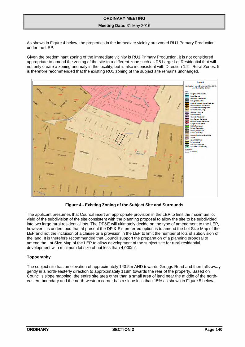
As shown in Figure 4 below, the properties in the immediate vicinity are zoned RU1 Primary Production under the LEP. Given the predominant zoning of the immediate vicinity is RU1 Primary Production, it is not considered appropriate to amend the zoning of the site to a different zone such as R5 Large Lot Residential that will not only create a zoning anomaly in the locality, but is also inconsistent with Direction 1.2 - Rural Zones. It is therefore recommended that the existing RU1 zoning of the subject site remains unchanged.
Figure 4 - Existing Zoning of the Subject Site and Surrounds The applicant presumes that Council insert an appropriate provision in the LEP to limit the maximum lot yield of the subdivision of the site consistent with the planning proposal to allow the site to be subdivided into two large rural residential lots. The DP&E will ultimately decide on the type of amendment to the LEP, however it is understood that at present the DP & E’s preferred option is to amend the Lot Size Map of the LEP and not the inclusion of a clause or a provision in the LEP to limit the number of lots of subdivision of the land. It is therefore recommended that Council support the preparation of a planning proposal to amend the Lot Size Map of the LEP to allow development of the subject site for rural residential development with minimum lot size of not less than 4,000m2. Topography The subject site has an elevation of approximately 143.5m AHD towards Greggs Road and then falls away gently in a north-easterly direction to approximately 118m towards the rear of the property. Based on Council’s slope mapping, the entire site area other than a small area of land near the middle of the north-eastern boundary and the north-western corner has a slope less than 15% as shown in Figure 5 below.
ORDINARY SECTION 3 Page 140

ORDINARY MEETING
Meeting Date: 31 May 2016
Figure 5 - Existing Slopes of the Subject Site The HRLS recognises slopes greater than 15% act as a constraint to development, and future subdivision of the site for large rural residential lots would need to be limited to that area of land having a slope less than 15%. Given this criteria, there is no significant slope constraint impounding upon the subdivision of the subject site into two lots.
Figure 6 - Slope Analysis (Lot Layout Not Adopted) As shown in Figure 6 above, Proposed Lot 11 has a fairly large developable area less than 15% in slope towards the rear of the subject site, whilst Proposed Lot 12 also has sufficient land area towards Greggs Road. As shown in Figure 6, the existing dwellings are entirely within the slopes less than 15%.
ORDINARY SECTION 3 Page 141
ORDINARY MEETING
Meeting Date: 31 May 2016
It is therefore considered that some form of dwelling, and an appropriate on-site sewage management (OSSM) system on the proposed lots could be accommodated within the area where slopes are less than 15%. Should Council resolve to proceed with the planning proposal and receive a Gateway determination advising to proceed with the planning proposal from DP&E, a preliminary wastewater feasibility assessment and a flora and fauna assessment need to be undertaken to demonstrate that the proposed lots are capable and have adequate developable areas to accommodate appropriate building footprints and OSSM system with no significant impact on the existing vegetation. However, the DP&E will be able to consider this matter as part of their “Gateway” determination. Ecology The planning proposal is not accompanied by a flora and fauna survey and assessment report, and the applicant provides the following information on flora and fauna on the site.
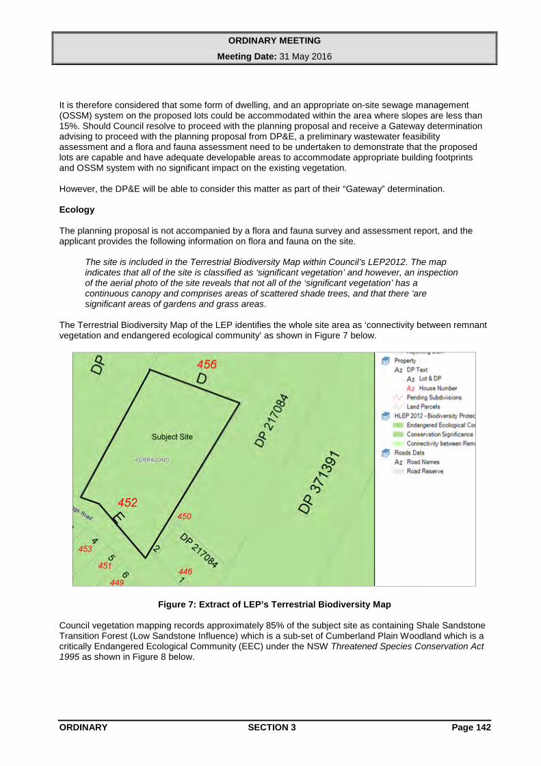
The site is included in the Terrestrial Biodiversity Map within Council’s LEP2012. The map indicates that all of the site is classified as ‘significant vegetation’ and however, an inspection of the aerial photo of the site reveals that not all of the ‘significant vegetation’ has a continuous canopy and comprises areas of scattered shade trees, and that there ‘are significant areas of gardens and grass areas.
The Terrestrial Biodiversity Map of the LEP identifies the whole site area as ‘connectivity between remnant vegetation and endangered ecological community’ as shown in Figure 7 below.
Figure 7: Extract of LEP’s Terrestrial Biodiversity Map Council vegetation mapping records approximately 85% of the subject site as containing Shale Sandstone Transition Forest (Low Sandstone Influence) which is a sub-set of Cumberland Plain Woodland which is a critically Endangered Ecological Community (EEC) under the NSW Threatened Species Conservation Act 1995 as shown in Figure 8 below.
ORDINARY SECTION 3 Page 142
ORDINARY MEETING
Meeting Date: 31 May 2016
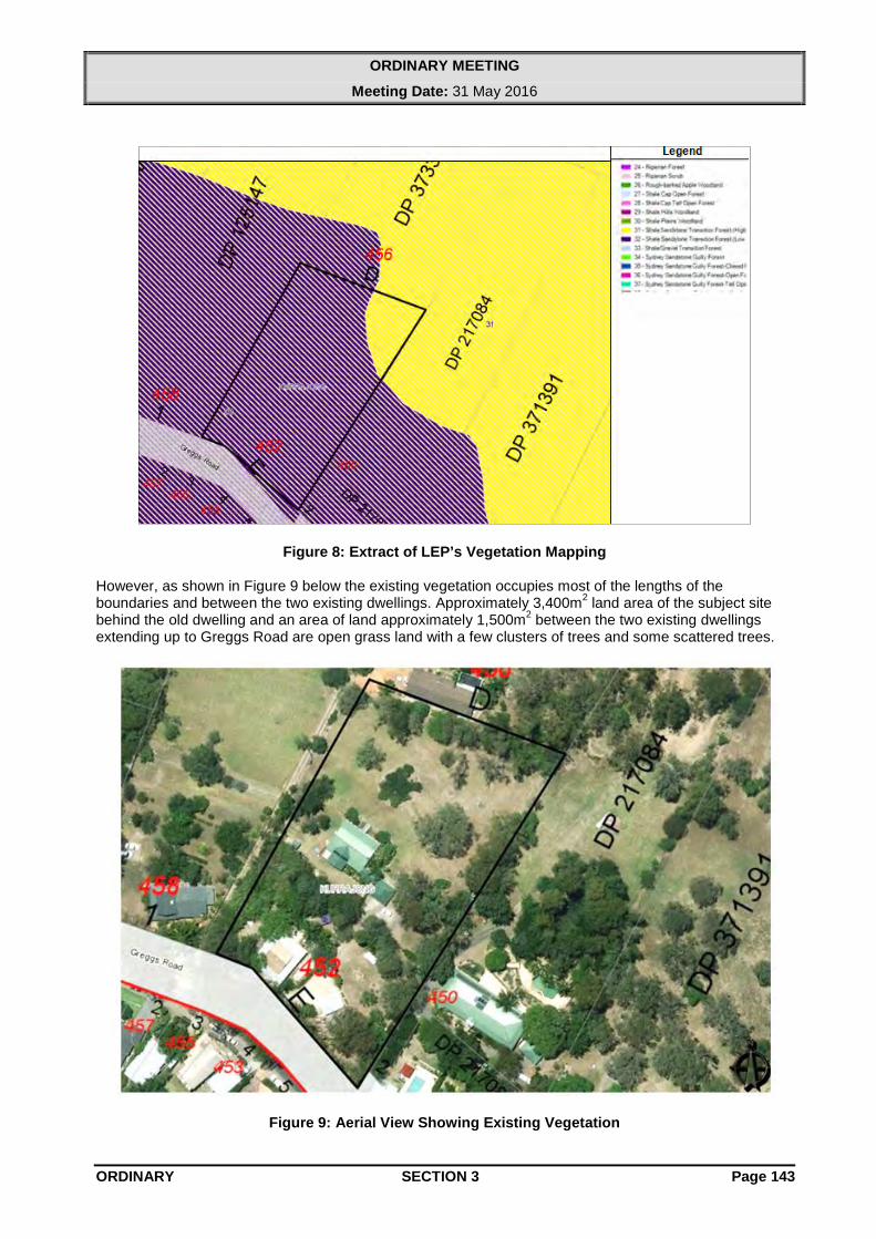
Figure 8: Extract of LEP’s Vegetation Mapping However, as shown in Figure 9 below the existing vegetation occupies most of the lengths of the boundaries and between the two existing dwellings. Approximately 3,400m2 land area of the subject site behind the old dwelling and an area of land approximately 1,500m2 between the two existing dwellings extending up to Greggs Road are open grass land with a few clusters of trees and some scattered trees.
Figure 9: Aerial View Showing Existing Vegetation
ORDINARY SECTION 3 Page 143
ORDINARY MEETING
Meeting Date: 31 May 2016
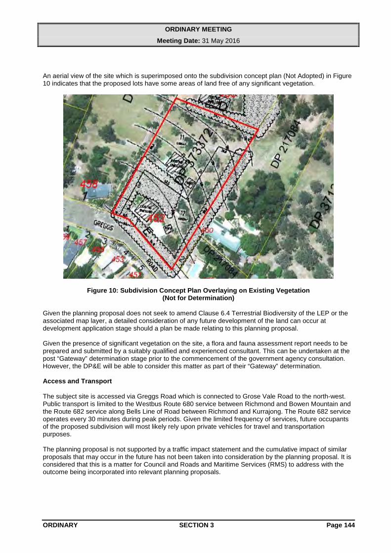
An aerial view of the site which is superimposed onto the subdivision concept plan (Not Adopted) in Figure 10 indicates that the proposed lots have some areas of land free of any significant vegetation.
Figure 10: Subdivision Concept Plan Overlaying on Existing Vegetation (Not for Determination)
Given the planning proposal does not seek to amend Clause 6.4 Terrestrial Biodiversity of the LEP or the associated map layer, a detailed consideration of any future development of the land can occur at development application stage should a plan be made relating to this planning proposal. Given the presence of significant vegetation on the site, a flora and fauna assessment report needs to be prepared and submitted by a suitably qualified and experienced consultant. This can be undertaken at the post “Gateway” determination stage prior to the commencement of the government agency consultation. However, the DP&E will be able to consider this matter as part of their “Gateway” determination. Access and Transport The subject site is accessed via Greggs Road which is connected to Grose Vale Road to the north-west. Public transport is limited to the Westbus Route 680 service between Richmond and Bowen Mountain and the Route 682 service along Bells Line of Road between Richmond and Kurrajong. The Route 682 service operates every 30 minutes during peak periods. Given the limited frequency of services, future occupants of the proposed subdivision will most likely rely upon private vehicles for travel and transportation purposes. The planning proposal is not supported by a traffic impact statement and the cumulative impact of similar proposals that may occur in the future has not been taken into consideration by the planning proposal. It is considered that this is a matter for Council and Roads and Maritime Services (RMS) to address with the outcome being incorporated into relevant planning proposals.
ORDINARY SECTION 3 Page 144

ORDINARY MEETING
Meeting Date: 31 May 2016
In recent reports to Council dealing with other planning proposals within the vicinity of Kurmond and Kurrajong it has been noted that Council has received petitions from residents west of the Hawkesbury River concerned about rezoning of land for residential purposes in the absence of required infrastructure upgrades. To address this it has been recommended (and subsequently adopted by Council) that Council commence the preparation of a Section 94 Contributions Plan for the land within the vicinity of Kurmond and Kurrajong to ensure that all proposed developments in the locality contribute the required infrastructure, specially road upgrade and provision, in the locality. Alternatively, applicants and Council can commence Voluntary Planning Agreement negotiations to address this issue. It is considered that it is a fundamental matter to be dealt with by Council prior to the finalisation of any planning proposals in the locality as the cumulative impact of these types of development could be unacceptable if no required improvements are made. Bushfire Hazard The subject site is shown as being bushfire prone (Bushfire Vegetation Category 1) on the NSW Rural Fire Service’s Bushfire Prone Land Map. The planning proposal is not accompanied by a bushfire assessment report. Given the site is identified as bushfire prone, the planning proposal will be referred to the NSW Rural Fire Service (RFS) for comments should Council resolve to proceed with the planning proposal and receive a “Gateway” determination advising to proceed with the planning proposal from DP&E. Agricultural Land Classification The subject site is shown as being Agriculture Land Classification 3 on maps prepared by the former NSW Department of Agriculture. These lands are described by the classification system as:
3. Grazing land or land well suited to pasture improvement. It may be cultivated or cropped in rotation with sown pasture. The overall production level is moderate because of edaphic or environmental constraints. Erosion hazard, soil structural breakdown or other factors, including climate, may limit the capacity for cultivation and soil conservation or drainage works may be required.
Given the proximity of the subject site to surrounding rural residential properties, and its size and proximity to the Kurrajong Neighbourhood Centre, it is considered that it is unlikely the site could be used for a substantial or sustainable agricultural enterprise. Character The applicant states that:
There would be some change to the landscape of the site and surroundings if the subdivision were to proceed. However, given that the site is close to the residential area of Kurrajong and given small lot development is also near to the site, the proposed subdivision would not be distinguishable in this overall context.
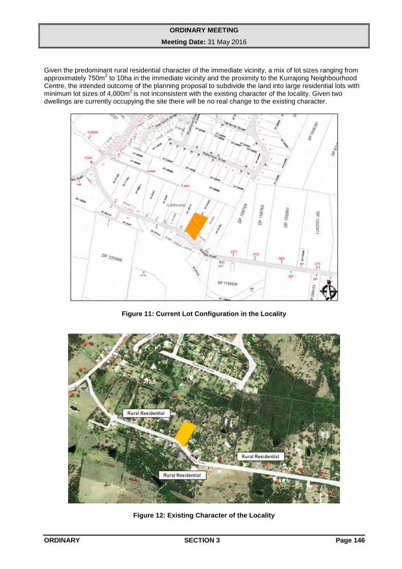
The immediate locality is characterised by a mix of lot sizes with varying frontages, shapes and areas. Smaller lots are located immediately opposite and adjacent in Grose Vale Road and to the north in Robertson Street. Larger lots are generally located to the east and further south as indicated in Figure 11. The predominant land use character in the immediate vicinity is rural residential as highlighted in Figure 12 below.
ORDINARY SECTION 3 Page 145
ORDINARY MEETING
Meeting Date: 31 May 2016
Given the predominant rural residential character of the immediate vicinity, a mix of lot sizes ranging from approximately 750m2 to 10ha in the immediate vicinity and the proximity to the Kurrajong Neighbourhood Centre, the intended outcome of the planning proposal to subdivide the land into large residential lots with minimum lot sizes of 4,000m2 is not inconsistent with the existing character of the locality. Given two dwellings are currently occupying the site there will be no real change to the existing character.
Figure 11: Current Lot Configuration in the Locality
Figure 12: Existing Character of the Locality
ORDINARY SECTION 3 Page 146

ORDINARY MEETING
Meeting Date: 31 May 2016
Services The applicant has stated that the site has access to electricity, telecommunication, garbage and recycling services, and additionally that:
The land has reticulated water but no sewer. Houses in this area usually rely on roof water catchment and sometimes supplemented by town water and also bore water or dams for non-potable supply. Effluent disposal would be by on-site treatment and each lot is of sufficient size to dispose of on-site effluent. It is not known at this early stage whether there will be additional water supply through Sydney Water reticulation however such is not required and a subdivision as proposed could exist satisfactorily without further reticulated water.
The planning proposal is not accompanied by a wastewater feasibility assessment report or any other relevant statement or study demonstrating that the proposed lots will be able to accommodate an on-site sewage system without affecting the existing vegetation and required asset protection zone. The development of the subject site will need to rely upon on-site sewage systems. Therefore, a detailed soil assessment will need to be undertaken at the subdivision application stage to confirm the exact sizing and location of the effluent disposal areas. However, the DP&E will consider this as part of their “Gateway” determination. Heritage The site is not identified as a heritage item/property in Schedule 5 Environmental Heritage of LEP 2012 or located within a conservation area and also not subject to any heritage order or identified as a heritage item. The applicant states that the old dwelling has been built around late 1920’s by Donald McAlister Greg who was one of the original orchardists in Kurrajong. The McAlister house still stands as an evidence of the type of dwelling of the period, being one of the first slab dwellings in the locality. According to a former Council’s Heritage Advisor, the old dwelling appears to have a reasonable case for listing the item, the physical evidence exhibited by the building is not clear and it would be prudent to undertake a detailed heritage assessment of the site and the building. However, this issue could be considered separately at a later stage. Section 94 Contributions or a Voluntary Planning Agreement The planning proposal should be covered by a Section 94 Developer Contributions Plan (S94 Plan) or a Voluntary Planning Agreement (VPA) prior to completion. The current Hawkesbury Section 94 Plan does not apply to residential development in Kurrajong. If the planning proposal is to proceed further, a draft VPA or an addition to the current S94 Plan to support the required infrastructure upgrade in the locality to support the development would need to be prepared by the applicant in consultation with Council. Conformance to the Hawkesbury Community Strategic Plan The proposal is considered to be consistent with the Looking after People and Place Directions statement, and specifically: • Offer residents a choice of housing options that meet their needs whilst being sympathetic to the
qualities of the Hawkesbury. • Population growth is matched with the provisions of infrastructure and is sympathetic to the rural,
environmental, heritage values and character of the Hawkesbury. • Have development on both sides of the river supported by appropriate physical and community
infrastructure.
ORDINARY SECTION 3 Page 147

ORDINARY MEETING
Meeting Date: 31 May 2016
Conclusion It is considered that some form of residential development on the subject site is appropriate and feasible. It is therefore recommended that Council support and submit the planning proposal to the DP&E for a ‘Gateway’ determination. Financial Implications The applicant has paid the fees required by Council’s fees and charges for the preparation of a local environmental plan. If the planning proposal is to proceed further, a draft VPA or S94 Plan to support the required infrastructure upgrade in the locality to support the development would need to be prepared by the applicant in consultation with Council. Planning Decision As this matter is covered by the definition of a “planning decision” under Section 375A of the Local Government Act 1993, details of those Councillors supporting or opposing a decision on the matter must be recorded in a register. For this purpose a division must be called when a motion in relation to the matter is put to the meeting. This will enable the names of those Councillors voting for or against the motion to be recorded in the minutes of the meeting and subsequently included in the required register.
RECOMMENDATION:
That: 1. Council support the planning proposal for Lot E DP 373372, 452 Greggs Road, Kurrajong to allow
development of the land for a large lot rural residential development with a minimum lot size of not less than 4,000m2.
2. The planning proposal be forwarded to the Department of Planning and Environment for a
“Gateway” determination. 3. The Department of Planning and Environment be advised that Council wishes to request a Written
Authorisation to Exercise Delegation to make the Plan. 4. The Department of Planning and Environment and the applicant be advised that in addition to all
other relevant planning considerations being addressed, final Council support for the proposal will only be provided if Council is satisfied that satisfactory progress has been made towards resolving infrastructure provision for this planning proposal by way of either completion of the Section 94 Developer Contributions Plan or a Voluntary Planning Agreement,.
ATTACHMENTS:
AT - 1 Proposed Minimum Lot Size Map
ORDINARY SECTION 3 Page 148

ORDINARY MEETING
Meeting Date: 31 May 2016
AT - 1 Proposed Minimum Lot Size Map
oooO END OF REPORT Oooo
ORDINARY SECTION 3 Page 149