c-306, montana, lokhandwala complex - strategic … montana, lokhandwala complex andheri west,...
TRANSCRIPT


C-306, Montana, Lokhandwala Complex
Andheri West, Mumbai 400 053, India
Email: [email protected]
www.strategicforesight.com
Project AdviceIlmas Futehally
AuthorsGitanjali BakshiSahiba Trivedi
CreativePreeti Rathi Motwani
Copyright © Strategic Foresight Group, 2011
Permission is hereby granted to quote or reproduce from this report with due credit to Strategic Foresight Group
Processed byMadderRed, Mumbai
FOREWORD
Strategic Foresight Group has been a consistent advocate of reason in relations between India and Pakistan. It has recognised water as a critical determinant of peace and development in many parts of the world. This paper brings together these two strands in our work.
It will be in order to recall some of the earlier work done by Strategic Foresight Group to urge rationality in India-Pakistan relations. In 2004, we published the first ever comprehensive assessment of Cost of Conflict between India-Pakistan in a report with this title. In 2005 we published The Final Settlement where we strongly argued that integrated water development would need to be a part of long-lasting solution between the two countries. Since then we have been regularly advocating a pragmatic approach for India and Pakistan to foster cooperation and move ahead to enable social and economic development of their people, instead of wasting precious resources on terrorism, counter terrorism and an arms race.
We initiated work on water on the advice of an international conference on Responsibility to the Future, which was co-hosted by SFG with the United Nations Global Compact, inaugurated by the President of India and attended by delegates from 25 countries in June 2008. We have since published reports on the crucial role played by water in many parts of the world, including The Himalayan Challenge which looks at future water security in the Eastern Himalayan River Basins, comprising of Bangladesh, China, Nepal and northern India. Our report The Blue Peace proposes how the water issue can be transformed from crisis to an opportunity in the Middle East. We are currently involved in an initiative to explore cooperative measures for sustainable water management between five countries in the Middle East.
This paper by Gitanjali Bakshi and Sahiba Trivedi, respectively present and former coordinators of the South Asia Security programme at SFG, examines water issue between India and Pakistan. The two countries should be proud that they have crafted Indus Water Treaty, which is seen by the world as an outstanding example of confidence building measures between neighbours involved in difficult relationship. It is necessary to build on this achievement to ensure that water needs of certain provinces do not deprive the poor people of Sindh and Balochistan provinces. Instead, the water discourse is often focussed on small technical issues, which are inflated to create a sense of discord. As the authors of this paper have demonstrated, the India-Pakistan controversy over Indus is much ado about nothing. It would be much better for the two countries to appreciate the unique Indus equation they have created through a historic treaty which has completed half a century of uninterrupted existence and nurture it for the decades to come.
Sundeep WaslekarPresident, Strategic Foresight Group
Mumbai, June 2011
I

CONTENTS
Foreword
Introduction
Overview of Pakistan’s Water Resources• The Western Rivers of the Indus
• Pakistan’s Chenab Formula
• Overall Supply and Demand
• Driving Factors for Rising Water Demand in Pakistan
• 1960 Indus Water Treaty
Internal Water Mismanagement
• Conveyance Losses
• Increasing Silt Levels in Dams
• Water Pollution
• Groundwater Pollution and High Salinity
• Corruption and Inefficiency in the Water Sector
• Low Expenditure on Water Sector Development
• Irresponsible Agricultural Practices
Other Matters of Concern
• Unequal Distribution amongst the Provinces
- PoK Compared to Pakistan
- Sindh Compared to Punjab
• Climate Change
Issues of Contention• Baglihar Dam
• Wullar Barrage
• Kishanganga Dam and Neelam-Jhelum Dam
• Bursar Dam
• Cumulative Storage - Damming of Western Rivers
• Underdevelopment in J&K
• Indian Support of Afghan Dams on the Kabul River
Conclusion
I
01
03
04
05
05
06
07
08
09
09
10
10
11
11
12
13
13
13
14
15
18
18
22
25
28
28
31
32
36

1
Like most rivers in the world, the Indus River in South Asia does not recognize political boundaries. It crosses over Tibet, India, Pakistan and Afghanistan before finally emptying into the Arabian Sea at the foot of the Sindh province in Pakistan.
The two main benefactors of the Indus River waters are India and Pakistan. After partition in 1947 these waters formed a major cause of tension between the two countries. The headwaters of the river were situated in India while the body formed Pakistan’s main source of freshwater.
In 1948 an Inter-Dominion Accord was set up wherein India was obligated to release sufficient amounts of water to Pakistan for a nominal fee in order to meet the country’s immediate requirements. However, a more permanent solution was needed when tensions over water arose once again in 1951. While Kashmir – one of the more intractable issues between India and Pakistan - seemed far from a resolution, water provided a stepping stone upon which India and Pakistan could start a process of reconciliation. Nonetheless, reaching an understanding over the most optimum distribution of the Indus River Waters was no easy task. It took nine years of negotiations before India and Pakistan signed the Indus Water Treaty (IWT) in partnership with the World Bank and with financial assistance from the U.S. and U.K.
The IWT provides a mechanism for amicable water sharing between India and Pakistan, a luxury uncommon to many countries that have Transboundary Rivers. Since its ratification in 1960, India and Pakistan have not engaged in any water wars. Disagreements, disputes and the need for arbitration have arisen however they have been settled via legal procedures - provided for within the framework of the IWT - and not via armed conflict. The treaty is considered to be one of the most successful water-sharing endeavours in the world today even though analysts acknowledge the need to update certain technical specifications and expand the scope of the document to include climate change.
As India and Pakistan stand at the threshold of yet another attempt to further cooperation, ‘water’ – as was the case in 1951 - can provide an impetus to tackle larger issues like Kashmir. There has been a lot of controversy and debate about the IWT, however, the core problems are minor in many cases and can be addressed with care through a process of negotiation.
Introduction

The Indus Equation 2 Introduction
The first section of this paper provides a comprehensive overview of Pakistan’s water situation; the second part discusses points of contention between India and Pakistan regarding the shared Western Rivers of the Indus and the conclusion provides the final analysis and recommendations that will assist water cooperation between these two nations in the future.
CHAPTER 1
3
Pakistan receives its water from 3 river basins – The Indus, Karan and Makran River Basins. Of these three, Pakistan is most dependent on the Indus River Basin as it covers 71% of its territory - comprising the whole of Punjab, Sindh, NWFP, PoK and the eastern parts of Balochistan - and provides water for 77% of the population. The Karan and the Makran originate along the plains of Balochistan and they cover only 15% and 14% of Pakistan’s territory respectively.
The Indus Basin has a large groundwater aquifer that covers 16.2 million ha (hectare). Groundwater is pumped with the help of tubewells, currently numbered at 0.9 million and 87% of these are run on diesel, making groundwater pumping impossible during Pakistan’s frequent periods of load shedding. Most urban and rural water is supplied from groundwater sources. Salt-water intrusion is a problem in Pakistan with about 36% of the groundwater classified as highly saline.
Average Annual Freshwater Availability, which accounts mainly for the Indus River Basin flow is pegged at 130MAF (million acre feet) but can reach as low as 116MAF per year.
In 2008, total water withdrawal was estimated at 148.68MAF (183.4km3) creating a deficit of roughly 18MAF. Surface water withdrawal accounted for 98.74MAF (121.8km3) and groundwater withdrawal accounted for 49.94MAF (61.6km3). [It should be noted that withdrawal here refers mainly to the Indus Basin Irrigation System (IBIS) as withdrawal outside of this is negligible.]
Annual precipitation in Pakistan is roughly 500mm although this varies with less than 100mm in certain parts of Balochistan and Sindh and 1,500mm in the foothills and mountains of Punjab and NWFP. There is also an extreme variability in rainfall between the seasons. There are 2 main rainfall seasons in Pakistan – Rabi season (October-March) and Kharif Season (April-September). 60% of the annual rainfall is received during the peak of the Kharif season from July-September.
Similar to the rainfall periods, 85% of the flow of the Indus is received during the Kharif Season (April to September) and the remaining 15% is received during the Rabi season (October to March). In addition, 80% of the water in the Kharif season is received from melt water.
Overview of Pakistan’s Water Resources

The Indus Equation Overview of Pakistan’s Water Resources4
Summary of Water Resources
The Indus River Basin has been studied more closely than the Makran and the Karan Basins because it contributes a majority of the water in Pakistan and it is a perennial river with availability throughout the year. It is also Transboundary River and this has necessitated more careful monitoring of river flows.
Total Average Renewable Freshwater Availability 2008 measured in MAF and Km3:
River Basins
Indus River Basin (Western Rivers)
Makran and Karan Basins
Afghan Use of Kabul River
Final Total
MAF
124-138
Less than 4
-8
120-134
Km3
170.27
Less than 5
-
Source: FAO, Aquastat, 2010 Version & Eng. Abdul Majid Kazi
It is important to note that according to Eng. Abdul Majid Kazi, WAPDA gives the Annual Average Water Availability of the Western Rivers as 140MAF (1976-2003) but this is because they only include readings from the wet periods. According to Kazi, a more comprehensive reading is 124MAF for 4 out of 5 years, a super flood occurring once every five years and an average of 138MAF for these five years. 8MAF should be subtracted from this amount due to Afghanistan’s use of the Kabul River, which incidentally contributes roughly 20MAF to the Indus River Basin, and less than 4 MAF should be added for the Karan and Makran Rivers. The range of total water availability is therefore between 120MAF and 134MAF.
Western Rivers of the Indus River System
1. The Indus River originates from a spring near the Mansarowar Lake, on the Northern side of the Himalayan Range in Kailas Parbat, Tibet, it is then joined by its five major tributaries (Jhelum, Chenab, Ravi, Beas, Sutlej), the Kabul River and several other small rivers as well. Pakistan’s Tarbela dam is situated on the Indus River along with several other barrages – Chasma, Kotri, Sukkur being a few of the important ones.
2. The Jhelum River arises from springs on the north western side of Pir Panjal that separates Jammu and Kashmir. It gets its water from various important sources including glaciers located in the north of the Kashmir valley. The River runs through the Dal and Wullar Lakes in J&K and therefore, feeds the supply of water to these lakes. The Jhelum is joined by its tributary the Kishanganga (known as Neelam in Pakistan) at Domail in Muzaffarabad in PoK.
3. The Chenab River arises in Himachal Pradesh in India and is formed by its two major tributaries the Chandra and the Bhaga. A large part of its catchment area is located in Jammu (part of J&K). It enters Pakistani territory upstream at the Marala Barrage. The total length of the Chenab is approximately 960km.
Source: http://acorn.nationalinterest.in/2005/01/08/sharing-the-indus/

The Indus Equation Overview of Pakistan’s Water Resources5
Pakistan’s Chenab Formula
Pakistan’s primary interest in Kashmir is to secure its major water resources as the headwaters of the Western Rivers are located here. J&K is often described as the ‘jugular vein’ of Pakistan.
“India has captured the jugular veins of Pakistan for the last 63 years in order to inflict destruction upon Pakistan but Pakistani leaders are not concerned about the seriousness of this issue. Pakistan should convey to India that a war is possible on the issue of water and this time war will be nuclear one.”- Nawa-i-Waqt Editorial, 4 April, 2011.
Jammu and Kashmir is considered an integral part of Pakistan’s food, water and power security. Water from J&K would provide much needed water for irrigation to Punjab and Sindh and alleviate tensions between these two provinces; it would also provide more irrigable land for Pakistan’s growing demand for wheat. Also, the viability of dam sites decreases at the lower end of the Western Rivers of the Indus with a much larger chance of silting. In J&K the flow of the rivers are strong and the estimated hydro-power potential of the state is 20,000MW. Pakistan’s combined potential is 40,000MW, so J&K could technically increase Pakistan’s hydro-power potential by 33%.
“Agreement on Kashmir, the source of water, on which Pakistan’s life and death depends, is vital otherwise nuclear war is hanging as the sword of Damocles’.”- Former IRSA Chairman Eng. Fateh Gandapur, 24 February 2011.
India is not allowed to harness this potential, however, as it can only build run-of-the-river projects in J&K, according to the provisions stipulated in the IWT. If it is able to take over the area, Pakistan will not be bound by such restrictions and the Chenab River has tremendous potential for hydel generation.
As elucidated in SFG’s 2005 report – ‘The Final Settlement’ - Pakistan can only secure complete control over the Chenab waters if it secures control
over certain parts of Jammu as a large part of the catchment area of the Chenab River lies in Jammu.
In 2005, Gen. Musharraf as well as other Pakistani leaders pushed for a resolution to the Kashmir issue through a roadmap they called the Chenab Formula. The formula, based on the ‘Dixon Plan’, assigns Ladakh to India, Gilgit-Baltistan (G-B) to Pakistan; it propounds a plebiscite in the Kashmir Valley and splits Jammu into two halves. The half accorded to Pakistan would be the half that contains the catchment area for the Chenab. At present (2011), the PPP Chairman Hilal Ahmed War has propounded PPP’s ‘Hilal formula’ as a potential roadmap for Indo-Pak talks on Kashmir however he has clearly stipulated in statements made to the press that the Chenab Formula, “can also be accommodated in the list of solutions.” If the army gains control over Pakistan in the future, the Musharraf formula will gain priority once again as the primary document for Pakistan’s resolution of the Kashmir issue.
Overall Supply and Demand
Historically, more attention has been given to water supply in Pakistan and measures that would help to enhance this supply such as dams and irrigation systems, however, little attention has been given to the demand side of Pakistan’s water nexus with negligible efforts to improve utilization and mitigate water losses. There is an urgent need to introduce demand-based management into the country, especially in Pakistan’s agricultural sector. In addition, marginal water, i.e. desalination and wastewater, is not pursued actively in the country however it could contribute substantially to enhancing water supplies.
According to Rao Irshad Ali Khan, Chairman of the Indus River System Authority (IRSA) Pakistan’s demand for water has already outstripped total supply by 11-12MAF. This gap between water demand and water supply is projected to reach around 31MAF by 2025. It should be noted that the gap between demand and supply widens in the summer (Kharif) season and towards the end of the watercourses.

The Indus Equation Overview of Pakistan’s Water Resources6
Pakistan’s Supply and Demand Gap
Deficit (MAF)
2010
2025
114-150
133-167Supply (MAF)
Demand (MAF)
102-136
102-136
12-14
31
* Supply here refers mainly to surface water availability and largely represents the Indus Basin. Sources: The following figures were derived from statements made by IRSA Chairman Rao Irshad Ali Khan and a paper by Shaheen Akhtar of the Institute of Regional Studies, Islamabad.
Per Capita Water Availability in Pakistan
Per
Capti
a Av
aila
bilit
y (m
3 )
0
1500
3000
4500
6000
1950 2005 2008 2010 2025
Sources: Final Settlement (SFG), Agricultural Water Demand Management in Pakistan (Kochi University Japan), Dr. Zakir Hussain VC University
Driving Factors for Rising Water Demand in Pakistan
The main factors driving water demand in Pakistan are agriculture, hydro-electricity and storage capacity.
Consumption of water is heavily skewed towards agriculture – as of 2008 the agricultural sector constituted 94% of total water withdrawal (172.4km3),
municipal use was estimated at 5.2% (9.7km3) and industrial use constituted 0.76% (1.4km3). This penchant is unlikely to change as agricultural output constitutes roughly 21% of the GDP, 50% of employment and provides 60-70% of Pakistan’s exports. However, overall irrigation efficiency in the Indus Basin Irrigation System is low at around 40%. Pakistan has one of the world’s largest contiguous irrigation systems. Consequently water losses through the system can be substantial and can be quite costly for Pakistan’s agri-economy.
Agriculture Muncipal Industrial
94%
5.2%0.76%
Agriculture Drives Water Demand
25000
15000
Northern Areas Other Areas
Pakistan’s Hydropower Potential in MW
Water is also essential for power generation - 29-32% of total power is generated through hydropower. According to the Managing Director of PEPCO, Munawar B. Ahmed, Pakistan faced an electricity

The Indus Equation Overview of Pakistan’s Water Resources7
deficit of 3,500MW in 2009. It currently has a hydel generation capacity of 6,493MW - generated by its 3 large hydropower dams (Tarbela 11.96km3, a raised Mangla 10.15km3 and Chasma 0.87km3) - but its total hydel potential is estimates at 40,000MW. Pakistan is pushing to increase its total installed hydropower capacity to an ambitious 20,000MW by 2017 and 27,000MW by 2025 as specified in WAPDA’s ‘Vision’ documents. Consequently, WAPDA has recently embarked on a series of new hydropower projects in PoK, many of them in collaboration with Chinese contractors – among these are the 969MW Neelam-Jhelum and 4,500MW Diamer Bhasha. It should be noted that out of the 40,000MW hydropower potential, 15,000MW (38%) are in the Northern Areas alone.
2010 2025
Current and Future Storage Capacity
Increased storage capacity is another reason why Pakistan wants to build more dams. IRSA Chairman Rao Irshad argues that the construction of the Kalabagh, Akhori and Basha dams can save Pakistan from massive damage during floods and can raise its storage capacity during lean rainfall years - from 8% of the total flow to 23%. However, others like water expert Idris Ahmed Rajput argue that if the Kalabagh Dam is built, the water flow to Sindh and KP will greatly diminish, causing severe damage to irrigation and water quality levels in these two provinces. In addition, a large percentage of Pakistan’s storage capacity (32% of Mangla and Tarbela dams) is lost to sedimentation or silt load; the Mangla Dam was raised to recover losses due to sedimentation. Shorter life-spans of existing dams due to silting will increase the demand for storage in Pakistan in the future. The WAPDA Vision 2025 document stipulates an
additional storage capacity of 64MAF (however it is unclear whether they have accounted for lost storage due to silting here).
1960 Indus Water Treaty (IWT)
The IWT, a trilateral agreement between Pakistan, India and the World Bank, basically agrees to the splitting of the Indus Rivers, awarding rights over the Eastern Rivers (Ravi, Sutlej, Beas) to India and the majority of the flow in the Western Rivers (Indus, Chenab, Jhelum) to Pakistan. India however, is accorded customary usage of water in the Western Rivers for agricultural purposes and run-of-the-river electricity-generation projects.
Average Annual Flow of the Rivers of the Indus River System
0 50 100 150 200
33 125 168 MAF
Eastern Rivers (MAF)
Western Rivers (MAF)
Source: Academic paper from Sher-e-Kashmir University
The Indus Water Treaty specifies the following allotments to India with regard to the Western Rivers:
Agricultural Use Permitted to India from Western Rivers
0 200000 400000 600000 800000
70,000
4,00,000 2,31,000 7,01,000acres
Indus (Acres)
Jhelum (Acres)
Chenab (Acres)
Irrigated Cropped Area (ICA)
The Indus Equation Overview of Pakistan’s Water Resources8
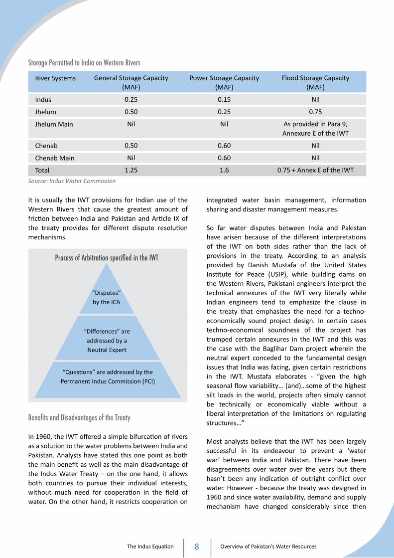
It is usually the IWT provisions for Indian use of the Western Rivers that cause the greatest amount of friction between India and Pakistan and Article IX of the treaty provides for different dispute resolution mechanisms.
“Disputes”by the ICA
“Differences” are addressed by a Neutral Expert
“Questions” are addressed by thePermanent Indus Commission (PCI)
Process of Arbitration specified in the IWT
Benefits and Disadvantages of the Treaty
In 1960, the IWT offered a simple bifurcation of rivers as a solution to the water problems between India and Pakistan. Analysts have stated this one point as both the main benefit as well as the main disadvantage of the Indus Water Treaty – on the one hand, it allows both countries to pursue their individual interests, without much need for cooperation in the field of water. On the other hand, it restricts cooperation on
integrated water basin management, information sharing and disaster management measures.
So far water disputes between India and Pakistan have arisen because of the different interpretations of the IWT on both sides rather than the lack of provisions in the treaty. According to an analysis provided by Danish Mustafa of the United States Institute for Peace (USIP), while building dams on the Western Rivers, Pakistani engineers interpret the technical annexures of the IWT very literally while Indian engineers tend to emphasize the clause in the treaty that emphasizes the need for a techno-economically sound project design. In certain cases techno-economical soundness of the project has trumped certain annexures in the IWT and this was the case with the Baglihar Dam project wherein the neutral expert conceded to the fundamental design issues that India was facing, given certain restrictions in the IWT. Mustafa elaborates - “given the high seasonal flow variability… (and)…some of the highest silt loads in the world, projects often simply cannot be technically or economically viable without a liberal interpretation of the limitations on regulating structures…”
Most analysts believe that the IWT has been largely successful in its endeavour to prevent a ‘water war’ between India and Pakistan. There have been disagreements over water over the years but there hasn’t been any indication of outright conflict over water. However - because the treaty was designed in 1960 and since water availability, demand and supply mechanism have changed considerably since then
Storage Permitted to India on Western Rivers
River Systems
Indus
Jhelum
Jhelum Main
Chenab
Chenab Main
Total
General Storage Capacity (MAF)
0.25
0.50
Nil
0.50
Nil
1.25
Flood Storage Capacity (MAF)
Nil
0.75
As provided in Para 9, Annexure E of the IWT
Nil
Nil
0.75 + Annex E of the IWT
Power Storage Capacity (MAF)
0.15
0.25
Nil
0.60
0.60
1.6
Source: Indus Water Commission

The Indus Equation Overview of Pakistan’s Water Resources9
- the question is less about the IWT’s durability and more about its adaptability.
Internal Water Mismanagement Pakistan’s water woes are often blamed on the upper riparian nation India with accusations that India is responsible for blocking Pakistan’s water supply. However, the reality is that the water shortage problems in Pakistan are not a case of obstruction by external forces but rather a case of wastage and unequal distribution by internal forces.
Conveyance Losses
Pakistan’s irrigation sector has some of the lowest conveyance efficiencies in the world. Conveyance losses result in water wastage within Pakistan.
According to a ‘Special Report on the Water Crisis in Pakistan’ by Pakissan (Pakistan’s largest agri web portal), 25% of the water diverted to the country’s canal system is misplaced in ‘line losses’ or pipe leakages. This point was elaborated further by former Foreign Minister S.M. Qureshi in a candid interview with a Pakistani news channel in April of 2010. Qureshi said in the interview, “The total average canal supplies of Pakistan are 104MAF and the water available at the farm gate is about 70MAF. Where does the 34MAF go? It’s not being stolen in India. It’s being wasted in Pakistan.” Qureshi received heavy criticism from his political colleagues in Pakistan for these comments however his point is valid; water losses do not only occur at the Indo-Pak border, they occur within the confines of Pakistan as well and these losses should be accounted for in order to get a comprehensive reading of Pakistan’s overall water situation.
A survey conducted in Punjab by Kahlown and Kemper in the Pakistan Journal of Water Resources, showed that it took 2 man hours to plug 14 out of 20 observable holes. This saved 3.9litres/second which resulted in a “76% increase of flow to tail end farmers in the field.” Line losses can easily be reduced, however, farmers are not being educated about
improving their water supplies and as a result, they spend much more money buying water from private tubewells.
Water wastage occurs in the urban and municipal sectors as well. In Islamabad alone, up to 30 million gallons of water is wasted daily due to shabby pipelines. This quantity is equivalent to the water stored in the Simly Dam. The water authority is supposed to upgrade the water supply network every decade as per the original master plan but it has failed to do so. Revamping the supply network has now become crucial as the population of the federal capital has crossed the figure of one million.
Increasing Silt Levels
Increasing silt levels in dams result in poor dam storage capacity. According to Eng. Fateh Gandapur, former Chairman of the Indus River System Authority (IRSA), very little attention is paid to the effects of silting on dam storage capacity in Pakistan. According to him, the Tarbela, Mangla and Chashma reservoirs together have silted up to 6.6MAF in the last 36 years. He says that the rapid silting has adversely affected the storage capacity created under the IWT and has harnessed inter-provincial disputes between Sindh and Punjab.
Watershed management measures like check dams, built along the catchment area, can reduce the speed of rainwater run-off and check soil erosion, thereby, increasing the lifespan and capacity of these dams. But as of 2010, no watershed management measures have been carried out in the catchment area of any of these dams. Pakistan’s solution to silting so far has been to raise the level of the dam, which leads to the displacement of people and environmental damage. Gandapur has also suggested several times in his blog that India should provide Pakistan compensation for this lost storage capacity as the dams in Pakistan were originally built as a compensation for the water supply they lost from the Eastern Rivers of the Indus after the IWT.
Silting in dams in Pakistan could reduce the original storage capacity by more than 45% in the future.

The Indus Equation Overview of Pakistan’s Water Resources10
Storage Loss due to Silting, measured in MAF
Reservoir
Tarbela
Mangla (after raising)
Chashma
Total
Storage Loss by 2010
2.92
3.16
0.44
6.52
Est. Storage Loss by 2020
-
-
-
8.3745
Storage Loss by 2001
-
-
-
3.46
Storage Capacity after Storage Loss due to Silting, measured in MAF
Reservoir
Tarbela
Mangla (after raising)
Chashma
Total
Current Storage Capacity (2011)
6.77
5.06
0.26
12.09
Storage Capacity (2020)
-
-
-
10.23
Storage Capacity
9.69
8.22
0.70
18.61
Source: Final Settlement and Ibrat newspaper, Sindh (15th April 2011)
Water Pollution
Water pollution, especially in the urban centres, has already resulted in a shortage of drinking water. A recent report in the Daily Times on World Water Day (22nd March 2011) stated that Pakistan’s water quality ranks 80th out of 122 nations. The report states that as much as 44% of the population of Pakistan does not have access to safe drinking water (72 million Pakistanis out of a population of 180 million) and the government will have to spend roughly Rs.20 billion each year on medication for water-borne diseases. The report also states that the number of terminal diseases like Hepatitis has increased due to Pakistan’s polluted water system and several of the elite have turned to bottled water as the only safe option.
Another report by the Asian Development Bank (ADB) in 2007 ranked Pakistan at the 17th position out of 23 developing countries in the index for drinking water
adequacy, stating that “the quality and reliability of urban water supplies are grossly inadequate.” “In the first half of 2006, major outbreaks of waterborne disease epidemics swept Faisalabad, Karachi, Lahore and Peshawar as a result of sewage and industrial waste leaking into drinking water through damaged pipes, necessitating a major emergency public investment programme to finance more than 6,000 filtration plants.”
40% of the water in urban metropolises like Karachi and Lahore is unfiltered and 60% of the effluents are untreated. Only 3 out of the 100 industrial complexes in Lahore chemically treat their waste, while in Karachi, the two largest industrial estates or zones in the country don’t have effluent treatment plants. Overall, wastewater treatment in Pakistan is negligible at less than 1% and agricultural waste is not filtered out of the drainage network. This low level of urban and agricultural sanitation within Pakistan has led to extensive pollution of the water supply system.
Groundwater Pollution and High Salinity
Groundwater pollution and salinization, caused mainly by over-pumping and rising sea levels, is a major problem in Pakistan, especially in areas of Sindh. According to the Soil Survey of Pakistan, 2.8 million hectares of irrigated land was affected by salinity in 1993. In 2007-08 this figure has increased to 6.8 million hectares. Judging by this trajectory as much as 9.5 million hectares of irrigated land in Pakistan, out of a total cropped area of 23.51, million hectares can be affected by salinity in 2020. Monitoring and controlling groundwater pumping has become difficult in Pakistan due to the increasing number of tubewells, currently at 0.9million and set to rise despite decreasing groundwater levels.
A majority of water for irrigation as well as domestic use in Pakistan is derived from groundwater sources. However, as these groundwater sources decline, there has been an increasing dependence on surface water flow. Currently, Pakistan has 68BCM of groundwater reserves, spanning across 16.2 million hectares of land, and already 36% of these reserves are considered highly saline – unfit for drinking purposes as well as irrigation. Groundwater levels
The Indus Equation Overview of Pakistan’s Water Resources11
in cities like Rawalpindi, Islamabad and Quetta have been declining by roughly 1-3.5 metres a year since the 1990s; some analysts have even warned that groundwater levels in Quetta could be completely exhausted in the next 10-15 years. As groundwater levels in Pakistan decrease, the dependence on surface water flow, especially from the Western Rivers of the Indus River system, will increase.
Corruption and Inefficiency in the Water Sector
Corruption and administrative inefficiencies in Pakistan’s water sector have hampered water aid and water development in the country and stunted growth considerably. In 2008, Transparency International’s (TI) Pakistan Chairman Syed Adil Gilani said that corruption in Pakistan’s water sector during the last decade had led to slow economic development, a shortage of power, inefficient irrigation methods as well as a shortage of potable water. TI surveys in 2003 and 2006 deemed the Water and Power Development Authority (WAPDA) to be the second most corrupt institution in the country receiving more than half of the 31,000 complaints that come into Pakistan’s anti-corruption ombudsman. Water has apparently become such a profiteering avenue in Pakistan that positions in the country’s water bureaucracy are sold at a high price.
The PPP AJK Minister Sardar Qamrazaman Khan said in an emergency press conference on 22nd March 2011 that embezzlement worth 1 crore and 60 lakh rupees was found out in the Kufah Garh Water Supply Project. – Jang, 22 March 2011.
Administrative inefficiencies have also resulted in water problems. Sindhi newspapers feature complaints by Sindh officials every other day, stating that repair work on embankments has been neglected for years. This is partly the reason why Pakistan suffered such massive devastation during the 2010 floods.
Another report in the Express Tribune corroborated this claim stating that the devastation from the 2010 floods “could have been contained had flood-
prevention projects been put in place. According to Idris Rajput, irrigation expert and former member of the Sindh government, these flood-prevention projects were not in place due to decades of government corruption and neglect.” According to the report the Federal Flood Commission (FFC) claimed that projects in the worst hit areas of Khyber Pakhtunkhwah (Nowshera and Charsadda) worth roughly Rs.77 million were 92% complete before the floods however these “projects are yet to be identified by locals on the ground.” The report also states that the Punjab Chief Minister had recently inspected bogus projects by the FFC in South Punjab. The FFC claims that the funds for flood-protection measures had already been released to the irrigation department officials in the province and one needs to ask these provincial officials where the money went. The two bodies are busy passing the buck but the fact remains that both the FFC as well as the provincial irrigation departments have misused and poorly managed the flood-prevention projects and as a result, hundreds of thousands of Pakistanis are suffering displacement, hunger and devastation.
Low Expenditure on the Water Sector Development
Low Expenditure on water sector development has decreased measures to enhance the water supply and control the rising water demand. Pakistan has never spent much on water sector development, utilizing only 0.25% of its GDP. To put this in perspective, military spending in Pakistan is 47 times this amount. An ADB report released in 2007 advised Pakistan to increase its water sector spending to a minimum of 1% of GDP, stating that the water use in Pakistan amounted to a zero in terms of efficiency.
The federal government is often unable to provide financial assistance to Sindh and PoK for their water development projects. Most of the schemes in these provinces are managed and funded by the provincial government through foreign loans. According to an article in the Express Tribune, most of the National Flood Protection Plans (NFPP) worth Rs87.8 billion that have been executed since 1978 has been funded through foreign loans from the Asian Development Bank, the International Development Association-World Bank and German financial organisation KFW.

The Indus Equation Overview of Pakistan’s Water Resources12
Japan has also made an additional grant of Rs348 million for the same.
Irresponsible Agricultural Practices
Outdated irrigation practices have lead to inefficient water usage in Pakistan. More than 95% of water withdrawals are used in the agricultural sector, however, 25% of this water is first lost through leakages and line losses in the canals and then only a certain amount of the remaining 75% of this water is actually absorbed and used by the crops due to poor soil texture and unlevelled fields. Hence, Pakistan wastes a lot of water first through conveyance inefficiencies and then through ‘on-farm’ or field application efficiency resulting in a final water efficiency which does not exceed 36%. Simply improving the on-farm water management and water infrastructure could make up for a substantial amount of the water that Pakistan wants to add through expensive mega-dam projects.
Water Requirements for Some Major Crops
0
500
1000
1500
2000
Wheat
400
Rice
960
Cotton
630
Sugarcane
1640
Maize
354
Aver
age
Seas
onal
Wat
er R
equi
rem
ents
(mm
)
Source: Agricultural Water Demand Management in Pakistan, SSMS
Cotton exports in Pakistan generate more foreign trade income than any other export item. However, cotton is a water-thirsty crop and it is grown for 8 out of 12 months in Pakistan. 1kg of cotton, which is enough to produce one T-shirt and a pair of jeans,
consumes 13,000 litres of freshwater. Sugarcane is another extremely water-intensive crop and it is grown throughout the year. In the future, as water supply dwindles and demand increases, Pakistan will nee alternatives to these water intensive crops in their export market.
Comparison of Productivity per Unit of Water
0
1
2
3
4
5
6
7
8
9
10
Canada
8.72
U.S.A.
1.56
China
0.8
India
0.39
Pakistan
0.13
Prod
uctiv
ity (k
g/m
3 )
Source: http://research.unl.edu/events/futureofwater/ppt/SKNebraska.pdf Courtesy Presentation by Tariq S in National Seminar on IWRM, 2005.
Pakistan has also developed agriculture in parts of the country that are not actually conducive to the practice. The Northern Territories in Pakistan have a substantial amount of rainfall. Most of the crops here are grown through rain-fed agricultural practices and are less dependent on irrigation. Sindh and Punjab on the other hand depend substantially on groundwater tubewells and surface water irrigation during crop production. Yet only 20% of PoK’s irrigable land is currently developed whereas 80% of the land in the rest of Pakistan is used for irrigation. This 80% is considered arid and semi-arid and is therefore highly dependent on the Indus Basin irrigation network and not rainfall to support its agricultural practices.
Corporate farming in Pakistan is another factor that could lead to an exponential and unnatural increase in water demand in Pakistan in the future. In 2009, Pakistan had considered leasing close to 1 million acres of its irrigated land to Arab countries for

The Indus Equation Overview of Pakistan’s Water Resources13
farming purposes. This leased land is mainly used to address food security concerns in foreign countries that do not have enough freshwater reserves so as the demand for freshwater and food grows in these foreign countries, so will the demand for land grabs and consequently freshwater resources in Pakistan.
Other Matters of Concern
Uneven Water Distribution amongst the Provinces
Pakistan’s Punjab province receives the lion’s share of the water resources in the country, while the impact of low water supply is felt much harder in Sindh and Balochistan. Unequal distribution rather than supply is another reason for the country’s water woes. More than the provinces, PoK suffers the most with negligible rights over the water resources that flow from its territory.
PoK Compared to Pakistan
Historically, the benefits for water development projects have not benefited the PoK region. Agriculture provides livelihood to 84% of the households in PoK. However, only 13% of the cultivable area in PoK is actually irrigated as compared to 80% of the cultivable area in the rest of Pakistan. Despite having one of the most extensive irrigation systems in the world, irrigation in PoK is grossly underdeveloped. The average farmer in PoK has 1.2 hectares of land and of this, 60% is either forest or wasteland, leaving only 0.47 hectares of actual farmland.
There is a growing feeling that Pakistan needs Kashmir only to satisfy the growing water demand in other parts of the country. Kashmiris say that the Mangla Dam is a glaring example of sacrifices made by the territory for the greater national cause. The raising of the Mangla Dam, built on the Jhelum River, is supposed to add 2.9MAF to Pakistan’s storage capacity and an additional 644MW to hydroelectricity generation in the country. However, the raising of this dam in 2003 displaced several people from the towns of Mirpur and Dadyal and compensations as well as
relocation of these people are still pending.
When the dam was first built in 1967 around 300,000 people were displaced. When it was raised to add additional benefits for the rest of Pakistan, between 40,000 and 80,000 more people were displaced from Mirpur. The local leadership as well as the population has had to struggle a great deal to secure compensation. WAPDA released the final instalment of compensation funds totalling $52 billion to the AJK government in January 2011 – 8 years after the raising was initiated. Many of those affected have still not been relocated and their eviction from their ancestral homes has become a serious issue. In fact, President Zardari cancelled his visit to inaugurate the project in Mirpur in January 2010 in order to avoid public pressure on rehabilitation issues.
Due to the pending matters of those affected by the dam raising project, the AJK government has prevented WAPDA from filling the dam to its new capacity. The Mangla Dam project and its subsequent raising, was supposed to have brought ‘hydro’ benefits for Pakistan and Pakistan occupied Kashmir but it has failed to do either.
IRSA has out rightly rejected water allocation of 613cusecs of drinking water to the residents of Mirpur that was supposed to come from the Mangla Dam and was promised to them by the Pakistan government in 2003. Despite being an upper riparian province, PoK is not included in the 1991 Water Distribution Accord and is therefore, expected to justify its most basic right to water availability, from the Mangla project as well as other projects, to the provinces of Pakistan.
In addition, Pakistan has lost an estimated Rs.18 billion a year that it could have earned from the irrigation and power generation from the additional dam capacity. Due to delays in relocation, Pakistan has also had to raise its compensation cost for those affected as the value of property has escalated over time. The cost for resettlement increased from an estimated Rs18billion to Rs.52 billion while confidence building measures and building infrastructure for the shifted town of Mirpur increased from Rs.5 billion to Rs.10 billion. Increased water capacity in the Mangla Dam was supposed to have been filled in 2010 but it will be filled in 2012 at the earliest. The total loss over

The Indus Equation Overview of Pakistan’s Water Resources14
3 years will amount to Rs.54 billion.
Instead of large mega-projects, Pakistani civil society and environmentalists have argued that adequate demand management measures will cost relatively less money and will have equal benefits. However, Pakistan has plans to build two more giant dams in its northern territories (PoK) namely, Skardu (Katzarah) and Diamer Bhasha. The Diamer Bhasha Dam is estimated to cost an astounding $8.5 billion and it has been indicated that the foreign debts accrued for the construction of the dam have been received in the name of Gilgit-Baltistan.
Even though PoK has low electricity demand, electricity tariffs in this area were Rs4.25 a unit while they were Rs.2.85 a unit in Pakistan. PoK is not considered a province of Pakistan and on these grounds, the Government of Pakistan does not have to pay the state royalties for dam projects being built there. Since 2003, the Mangla Dam has been the only exception to this rule and still Pakistan pays the “Azad Kashmir” Government 15 Paisa per unit while it pays 70 Paisa per unit to the other provinces of Pakistan.
Sindh Compared to Punjab
Sindh often claims that upper riparian state Punjab siphons excess water from the Indus River System through excessive groundwater pumping and canal diversions when this water rightfully belongs to Sindh.
The 1991 Accord has been the most recent document that specifies the distribution of water between Pakistan’s provinces Sindh and Punjab. Although it is controversial, the agreement has largely been established as the basis for water-sharing.
The main problem of the water accord is that the total water availability from the Indus River System is fixed at 117MAF. However, in reality, this amount fluctuates quite drastically; in 2000-2001, the water availability was as low as 70-75MAF. Under such conditions the new allocation is based on a ‘historical use’ clause which favours Punjab.
Punjab has 31 small dams that provide irrigation facilities to about 36,000 acres of land. It has sole rights to the Mangla Dam water whereas Sindh is
expected to share the water stored in the Tarbela with Punjab as well as the other provinces. In addition to these privileges the Punjab government wants to build the Kalabagh Dam in order to enhance its storage capacity even further however, it has not been able to execute this project due to a firm resistance from Sindh as Sindh believes that the dam will greatly curtail the share of water flowing to the areas below Kotri.
Water Distribution According to the 1991Accord (In MAF)
Punjab
Sindh
KP (NWFP)
Balochistan
37.07
33.94
3.48
2.85
18.87
55.94
48.76
5.7
3.87
14.82
2.3
1.02
Kharif Season (total : 77.34 MAF)
Rabi Season (total : 37.01 MAF)
Source: Final Settlement, SFG, 2005*Please note that PoK does not feature in this allocation.
Punjab has successfully constructed the Thal canal, another project vehemently opposed by Sindh. It provides an additional 1.9MAF of water from the Tarbela Dam to the Bhakker, Layyah, Jang, Khushab and Muzzafargarh districts of Punjab. Interestingly, these areas contain a concentration of private landholdings by senior military officials of the Pakistan army. In fact, since the 1960s many senior and junior army officers have been allotted land at throw-away prices in this area, known as Cholistan, and other parts of Punjab as well. In 2003 General (Retd.) Pervez Musharraf allotted a large chunk of land in Cholistan to himself and other Generals. Incidentally, Cholistan Bahawalpur also has a large concentration of jihadi groups.
Sindh representation in the Indus River System Authority (IRSA), the main body for decision-making on Indus river distribution, has been brutally low.

The Indus Equation Overview of Pakistan’s Water Resources15
According to Former Irrigation Secretary Idris Rajput, Sindh’s water interests are not being represented in IRSA since the Chief Engineering Advisor to IRSA is from Punjab and Sindh has just 20% representation in IRSA right now when it should legally be 40%. This skewed representation can once again give Punjab an undue advantage over provincial water distribution.
Decreased water supply to Sindh has resulted in a drastic drop in water sent down the Kotri stream from 117MAF in 1947, to an allocated 10MAF in the 1991 Accord, to barely 0.28MAF in 2009. As a result the deltaic area has been reduced; mangrove forests in the delta which originally occupied an area of 2,600sq.km, has now been reduced to 260sq.km. Decreased flow has also led to saltwater intrusion. According to the Pakistan National Institute of Oceanography and National Science Foundation, salt water intrusion into the plains and coastal areas of lower Sindh is directly related to the decrease of flow in the River Indus. Salt-water intrusion has moved inland up to 100kms north of the sea. Throat swelling due to drinking brackish water is a common complaint witnessed in the coastal areas of Sindh and seawater has rendered fertile agricultural lands useless. Hundreds of villages in the Badin and Thatta districts have been deserted and around 3.5 lakh people have been forced to migrate to some other areas in search of livelihood. The saltwater intrusion has also led to the demise of three commercial towns namely, Ghorabhari, Shah Bandar and Ketti Bandar resulting in a loss of industry that was estimated at 2% of the national GDP.
0
2.5
5.0
7.5
10.0
1991 2001 2002 2003 2009
10
2.15 1.92
0.74 0.28
Reduction in Flow in the Kotri Stream (in MAF)
Climate Change
According to recent studies the Himalayan glaciers will continue to retreat over the next 50 years and beyond as a result of climate change. This will cause a shrinking of glaciers, erratic snow patterns, erratic rainfall patterns, natural disasters and affected flow-patterns in the Himalayan Rivers, particularly the Indus.
Indus River flows are heavily dependent on glacial and snow melt (jointly termed melt water) and hence all the riparians will face the impact of climate change in the future. On several occasions Indian dams in J&K have been blamed instead of climatic factors for low flow periods as well as flash floods in Pakistan, however, these allegations benefit neither side.
Eventually, cooperation and not accusations will help reduce the impact of climate change in the two countries. Pakistan will benefit greatly because it receives more than 80% of its water supply from the Indus River, India’s cooperation will ensure a greater trust relationship with Pakistan and joint studies on climate change will offer a more comprehensive understanding about the water situation in the region, including not just man-made issues but environmental factors as well.
Climate Change vs. Dams
Meltwater constitutes the main flow of the Indus River; 1.5 times that of rain. According to the International Centre for Integrated Mountain Development in Kathmandu (ICIMOD) meltwater contributes 44.8% of the river flow, out of which, 40% is derived from glacial ice and from seasonal snows. According to a 2010 Dutch study however, 60% of the Indus River is made from Himalayan meltwater. (This study also states that there will be an 8.4% decrease in upstream water flow in the Indus River by 2050 due to climate change). Hence, approximately 40-60% of the water flow in the Indus River is meltwater from the Himalayas. As weather patterns become erratic and the Himalayan glaciers begin to melt, the flow patterns in the Indus River will increase in the short-term but decrease dramatically in the long-term.
The Indus Equation Overview of Pakistan’s Water Resources16
Chinese officials have commented on the impact of climate change on the Indus basin as well, particularly with regard to Pakistan. The former head of China’s Meteorological Administration Qin Dahe has said that the temperatures in China are rising four times faster than anywhere else. As a result, the Tibetan glaciers are retreating faster than other glaciers in the world. The short-term impact of this will be an increase in the formation of glacial lakes as well as the frequency of floods and mudflows and the long-term impact will be a decrease in river flow pattern. According to Dahe – once these glaciers vanish “water supplies in Pakistan will be in peril.”
Climate change is a reality that still needs to be factored in when discussing Transboundary Rivers in this region. In the next few years, as the flow of the Indus becomes more erratic and flash floods become more erratic, it will be essential for Pakistan to accept that Indian dam building has very little to do with this. Only then can progress on cross-border water issues be made in an effective manner.
Pakistan has blamed Indian damming for the devastating flash floods in July 2010 that impacted nearly a fifth of Pakistan’s land area. However according to NASA’s satellite images this catastrophe was the result of unusually heavy monsoons, potentially caused by the La Niña effect that enhances the Asian Monsoon. NASA also stated that high temperatures in the northern Indian Ocean and waters off the coast of Pakistan (the Arabian Sea) could have enhanced the monsoon rains as they were warmer than normal.
Victims on Both Sides of the Border
Both India and Pakistan are victims of climate change. In August 2010, Ladakh in India witnessed one of the most devastating flash floods in its history. The floods were a result of a cloudburst, which is unusual in Ladakh as it is essentially a cold desert with average annual rainfall being very low. This was obviously a result of the changing climate.
As the Himalayan glaciers retreat, the most important short-term impact will be the Glacial Lake Outburst Floods (GLOFs). A GLOF occurs when a glacier that contains a lake collapses, causing a sudden outburst
of water. There are many natural factors that can result in GLOFs - erosion, volcanic eruptions and earthquakes - however climate change and the melting of glaciers will increase the frequency of GLOFs. In the past two hundred years, 35 destructive GLOF events have been recorded in the Upper Indus River system. According to the ICIMOD, the Indus basin has a total of 2,420 glacial lakes in the ten sub-basins of Indus River system namely Swat, Chitral, Gilgit, Hunza, Shigar, Shyok, Upper Indus, Shingo, Astor and Jhelum. These sub-basins cover the Hindu Kush-Himalayan region in Pakistan. The ICIMOD study termed 52 of these glacial lakes as being potentially dangerous.
Need for a Joint Mechanism
The increasing frequency of flash floods and GLOFs in the coming years can cause mass migration of people in search of more secure places to live and several humanitarian casualties. It would behoove India, Pakistan and other riparians like China to cooperate on issues such as disaster management and early warning systems. In the future, a decrease in water flows may threaten food security since India and Pakistan as well as China and Afghanistan have primarily agro-based economies. Hydel generation, to meet growing energy needs, is another important resource that could be affected severely in all of these nations, particularly lower riparians in the coming years.
India and Pakistan, the two largest riparians of the Indus Rivers, can start this process by creating a joint mechanism on climate change. This would involve conducting joint studies on the extent of glacial melt, creating joint mitigation and adaptation techniques, sharing information and improving flood forecasting systems. According to B.G. Verghese, debris dams, torrential surges and glacial lake outbursts are already on the increase and these can cause severe damage to both India and Pakistan if they are not adequately monitored and managed. This could be a specific area for cooperation. The effects of climate change on the Indus River basin make it imperative that the two countries discuss the water issue comprehensively.
Since the Indus Waters Treaty does not address the sharing of waters between India and Pakistan with

The Indus Equation Overview of Pakistan’s Water Resources17
the provision of effects of climate change, the two countries need to hold discussions on the treaty in order to make amendments to its present structure.
The Siachen Glacier
A study conducted by Arshad H. Abbasi for WWF said that the Siachen Glacier was melting at an alarming rate because of military activities by Pakistan and India. Burning of fuel for sustenance of troops and transportation of war material, results in the release of an estimated 200 tons of CO2 into the atmosphere daily. Factors like permanent base camps on the glacier, hourly helicopter flights to retrieve soldiers and drop off supplies, dumping military garbage and human waste and a 120-km-long oil pipeline for heating igloos are causing a severe rise in temperatures and environmental degradation in and around the glaciers.
The Siachen Glacier is the source of the Nubra River in India that falls into the Shyok River in Laddakh-India which then empties into the Indus. Due to the geographical slope of the Indus basin, a faster melting Siachen Glacier means greater chances of flooding in the Indus basin and more frequent avalanches. De-militarizing the Siachen glacier could therefore deal with two of the main issues plaguing the Indo-Pak peace process – the Siachen Glacier as well as Water.

18
1. Baglihar Dam
Dam Controversy Time Line
Issues of ContentionCHAPTER 2
Baglihar Dam construction starts |
Pakistan raises objections |
January : Pakistan raises 6 objections with the World Bank |Issue is deemed as ‘Difference’
May : Swiss Civil Engineer Prof. Raymond Lafitte is appointed |the Neutral Expert
Construction is completed on the baglihar Dam |
Pakistan raises objections over the filling of the dam |
February : Neutral Expert Raymond Lafitte clears the Baglihar Dam with minor changes in design
India and Pakistan agree over the objections on the filling of the Baglihar Dam, after various rounds of talks
Several rounds of talks held, but to no avail
1999
2004
2005
2007
2008
2010

The Indus Equation Issues of Contentment19
Decisions
Decision Made by the NE on the 6 points of Contention
Indian Perspective
Pondage of 37.5MCM.
Freeboard Height of 4.5 metres.
Gated spillway required.
Gated spillway at right height.
Probable Maximum Flood (PMF) of 16,500 cumecs.
Water intake at 818 metres.
Pakistani Perspective
Excessive. Pondage of 6.22MCM would be adequate.
Freeboard of 1.5 metres would be adequate.
Gated spillway not required.
Gated spillway not at highest possible level.
Too large. PMF of 14,900 cumecs would be adequate.
Water intake at Dead Storage Level 835 metres.
Neutral Expert’s Decision
Reduce Pondage to 32.58MCM.
Reduce Freeboard to 3 metres.
Pakistani objections rejected. Gated spillway required.
Pakistani objections rejected. Gated spillway required for efficient maintenance. Recommended lowering of the spillway by another 8 metres.
Pakistani objections rejected.
Raise water intake to 821 metres.
Pakistan raised six main objections to the design of the Baglihar project and they are mentioned in the table above. Consequently, India gave responses to each of these 6 objections and ultimately, the Neutral Expert, Raymond Lafitte, gave his ruling on all of these six points.
Lafitte’s ruling on the Baglihar Dam elucidates the fact that Pakistani objections to Indian run-of-the-river projects on the Western Rivers of the Indus are more a reflection of Pakistani ‘lower riparian’ anxieties than an actual Indian violation of the IWT. The table above shows that Lafitte’s neutral ruling on the capacity of pondage, the height of the freeboard, the gated spillways and the PMF are more or less in tune with the initial calculations made by India, and his ruling was based on specifications written in the IWT.
Analysis
With regards to run-of-the-river projects on the Western Rivers of the Indus, disagreements between India and Pakistan arise over the interpretation of
the IWT. According to Danish Mustafa, of the United States Institute for Peace (USIP), Pakistani engineers interpret the technical annexures of the IWT very literally while Indian engineers tend to emphasize the clause in the treaty that emphasizes the need for a techno-economically sound project design.
India’s main argument, supported by the neutral expert Lafitte in the case of Baglihar, has always been that certain technical specifications in the treaty might not be the most feasible and sustainable options since these specifications were written in 1960. Even Mustafa, an expert on Pakistani water affairs, concedes to the fact that, “projects often simply cannot be technically or economically viable without a liberal interpretation of the limitations on regulating structures…”
Reservoir Flushing
In the case of the Baglihar project, the main argument was on the periodical flushing of the reservoir for desilting purposes that would be done through

The Indus Equation Issues of Contentment20
spillway gates. According to Pakistan the spillway gates fell below the Dead Storage Level (DSL) when the Indus Water Treaty specifies that there should be “no outlets below the DSL” in run-of-the-river projects. John Briscoe, a World Bank official who has argued the Baglihar case on behalf of Pakistan, has said that including these gates can be construed as a ‘re-interpretation of the IWT’.
The Neutral Expert however felt that these spillway gates were in fact very necessary in the Baglihar project for sediment control and the evacuation of the design flood, in fact he even said that they should be placed 8m below the level specified in the Indian design. Indian water expert Ramaswamy Iyer has written that the NE’s decision on this matter does not come as a surprise as any international civil engineer will agree that maintenance (in other words de-silting or reservoir flushing) is an integral part of any ‘sustainable’ hydro-project.
According to Iyer, India cannot simply forgo maintenance of its projects to satisfy Pakistani emotions. In addition, Iyer contends that both Briscoe and Pakistan have only partially represented this particular clause on ‘gated spillways’ in the IWT. The IWT specifies that outlets below the dead storage are not allowed “unless sediment control or other technical considerations necessitate this”.
Specifically, clause iv) says that: If gated spillways are considered necessary in the conditions obtaining at the site, the bottom of the gates shall be located at the highest level consistent with sound and economical design and satisfactory construction operation.
The Indus River Basin carries some of the highest silt loads in the world – an estimated 400 million tonnes while the Ganga carries 159 million tonnes and the Nile River 150 million tonnes. Iyer concludes that in the case of Baglihar and now in the case of Kishanganga (where a similar argument is being made) reservoir flushing is absolutely necessary. If this maintenance is not conducted then the reservoir will silt up rapidly and will subsequently become inoperable. Perhaps this is what Pakistan wants as it would ensure that the run-of-the-river projects have an extremely short lifespan.
Pondage and Probable Maximum Flood (PMF)
Pakistan viewed India’s planned pondage of 37.7MCM on the Baglihar as excessive. Water storage is not allowed according to the IWT (which is why it is not even plausible for India to block water to Pakistan through a run-of-the-river project). However, pondage or the limited quantity of water that can be held behind the dam for operational purposes is permitted in run-of-the-river projects and should be twice the pondage required for ‘firm power’ projects. Pakistan argued that pondage in Baglihar should be no more than 6.22MCM however the NE only reduced the capacity of the pondage from the Indian measure of 37.7MCM to 32.58MCM. The disagreement over the pondage issue is highly technical according to Iyer and has to do with the different understandings of ‘firm power’.
Pakistan had also calculated the Probable Maximum Flood (PMF) - i.e. the highest level in the lake that results in the maximum discharge from the hydraulic works - as 14,900 cumecs and based on this argument it wanted to nullify the necessity of gated spillways however, the NE accepted India’s figure of 16,500 cumecs as a more accurate reading of the PMF and consequently he also felt that there was a necessity for India’s sluice spillway gates as a measures for sediment control and evacuation of design flood.
Height of Freeboard and Water Intake
One of Pakistan’s other objections was that the freeboard designed for the Baglihar dam (or the level of the dam wall above the water level) should not be more than 1.5m. It felt that the freeboard designed by India, with a height of 4.5m, would allow India to raise the water level above the specified amount however India contended that a. a freeboard of this height was a standard safety feature and b. the water level in the dam could not be raised without “endangering the safety of the structure”.
Lastly, India and Pakistan disagreed on using the water intake level to prevent the formation of swirls and vortices in the plant. India said that water intake had to have an adequate body of water above it known as a water seal in order to prevent these

The Indus Equation Issues of Contentment21
vortices while Pakistan contended that there were other ways to prevent the formation of vortices. The NE partially accepted Pakistan’s view to this one point by suggesting that the water intake be raised by 3m.
Dam Filling
Another argument that Briscoe makes apparently is that after the arbitration over the Baglihar Dam was over, India decided in 2008, to fill the Baglihar exactly at the time when it would do farmers downstream in Pakistan the most harm. According to Briscoe, India chose to fill the dam during the monsoon or Kharif period (June to September) and blocked pertinent water to Pakistan’s farmers during the most important time for irrigation in the agriculture sector.
Iyer responds to this allegation using several different points. Firstly, Iyer writes that in order to fill a reservoir on the Chenab a minimum flow of 55,000 cusecs is required and this high flow is only available during the monsoon period. Hence, filling of reservoirs on the Chenab can only occur during the Kharif season and this is the time specified by the IWT itself (June 21st to August 31st). Secondly there is bound to be a brief interruption of flow to the other side as it takes time for the waters, rising against the dam wall, to reach the specified outlets (Iyer says in fact that if Pakistan had won on its insistence to raise these outlets to a higher height during the initial dispute the water would have taken even longer to reach the Pakistani farmers). It is true that the IWT requires a minimum flow of water to be maintained during the filling of the dam but this is technically impossible for the reasons mentioned above.
Iyer’s third argument addresses two accusations by Pakistan – the first stating that India violated the specified period for dam filling which is between June 21st and August 31st as filling continued till September and the second stating that the flow was reduced below the minimum level of 55,000 cumecs. Iyer’s first defence is that the accuracy of the first accusation has obviously not been checked by Briscoe as the dam filling stopped on the 28th of August. On the second point – Iyer does concede to the fact that, by his estimation, the water level did fall to 25,000 or 30,000 cusecs (which is still higher than Pakistan’s figures) and that this could have been
avoided if India had started filling the dam in July as opposed to August, however, construction was not completed until August so India had very little choice in this matter. If India had not started filling the dam in August (which was still within the specified IWT timeframe) they would have had to wait for one more year to pass before they could have attempted to fill the dam again.
In any case, this was more a matter of time constraints than a deliberate attempt to block Pakistani water. It was also a “one-time shortfall” that occurred for less than a day during India’s filling of the Baglihar dam and can hardly be considered a major deviation from the treaty. Even so, India has agreed that in the future it will evolve a proper consultation process with Pakistan while filling dams in order to obviate such controversies.
In summation, the hue and cry that was created in Pakistan over the Baglihar dam filling in 2008 was a last ditch attempt to prove that the Baglihar Dam will obstruct water flow to Pakistan; Pakistan felt perhaps that it needed to prove this point somehow after it lost the arbitration process with the Neutral Expert. There have been no incidents concerning this run-of-the-river project since 2008 and Pakistan has agreed that it will not pursue the Baglihar filling issue any longer.
As a side note it is also important to note that there are other inflows to the Chenab River apart from the flow that runs through the Baglihar Dam and all of these should be taken into account in the case of reduced water flow to Pakistan.
Lower Riparian Anxiety and Gracious Neighbours
Briscoe is often quoted in Pakistan with regard to Indo-Pak water issues and especially with regard to the Baglihar dispute. As he was a former World Bank official who had worked in both India and Pakistan he is largely considered a neutral observer. However his arguments on Indo-Pak water issues do carry a bias in favour of Pakistan.
John Briscoe argues that India, as the upper riparian in the case of the Indus Basin, should understand Pakistan’s “Lower Riparian Anxieties.” However what

The Indus Equation Issues of Contentment22
Briscoe fails to mention is that Pakistan has less cause to complain than most other lower riparians the world over. India and Pakistan have enjoyed a water treaty on the Indus basin for more than 50 years now while India itself does not enjoy a similar privilege with China with regards to the Brahmaputra. New Delhi has allowed Pakistan to inspect projects on the Western Rivers of the Indus when it has voiced concerns about them; on the other hand, Beijing has no such arrangement with New Delhi for water that flows into India from Tibet (which is where India’s largest river, the Brahmaputra, originates). In addition, there are indications that China plans to divert waters from Tibet to its dry northern region through its South-north project and this plan has received approval from President Hu Jintao. The ‘lower riparian anxiety’ would be more aptly placed in the case of India, China and the Brahmaputra River where there is no treaty and evident plans that could endanger water flows to India than in the case of India, Pakistan and the Indus River where there is a clear treaty that has been followed for more than half a century now.
The second point often made by Briscoe with regard to Indo-Pak water relations is that India should be as gracious with its lower riparian as its BRIC counterpart Brazil has been with its neighbour Paraguay when it doubled the payments received by Paraguay from the Itaipu Binacional Hydropower Project. Briscoe neglected to mention that India and Brazil have two completely different water scenarios. In 2007, per capita water availability in Brazil was 43,027 m³ per year. The world average was 8,209 m³ per capita in the same year, while India’s per capita water availability was a mere 1,730m3 in 2006. With such high water availability it seems obvious that Brazil is in a better position to be generous with its lower riparian states. In any case BRIC is not a grouping of sound conceptual basis. It is merely a term coined by Goldman Sachs to indicate countries with a high potential for GDP growth. And out of the BRIC countries it is China not Brazil that is the closest in terms of geography. Would Briscoe recommend that India follow China’s Mekong river policy with regards to its lower riparians, merely because China is India’s BRIC partner?
India needs to follow a water policy with Pakistan within the context of its unique water situation, on its own merit and within the framework of the Indus
Water Treaty and both India and Pakistan need to honor the decision of the Neutral Experts in order to contribute to the sustainability of the treaty. There are concerns that India’s development projects can lead to a suspension of the IWT. However, Pakistan’s repeated objections on every single development project on Kashmir can also lead to the dissolution of the IWT.
2. Tulbul Navigation Project (Wullar Barrage):
Dam Controversy Time Line
India starts work on the Tulbul Navigation Project.
Pakistan refers its objections (questions) to the Permanent Indus Water Commission.
After deliberation between the two sides the Indus Water Commission records a failure to resolve the matter.
Pakistan agrees to the barrage, but only after Pakistani inspection. India rejects the offer.
India offers to forgo initial storage capacity. Pakistan makes its agreement conditional on the cessation of work on the Kishanganga Project. India rejects the offer.
1984
1986
1987
1989
1991 1992
Decisions
As of 2010, 13 rounds of secretary-level talks have been held on the Wullar Barrage issue. It still remains unresolved. India suspended construction in 1987.
Analysis
The main argument on the Tulbul Navigation Project is the effect that this structure could have on the flow of the Jhelum River. Pakistan believes that the structure is in violation of the IWT design specifications and it

The Indus Equation Issues of Contentment23
will hamper the flow of the Jhelum River during the low flow periods. India has provided re-assurance that it will modify the design to suit the specifications in the IWT and it has said that the aim of the barrage is to enhance the level of flow in lean months and not the other way around.
Source: The Times of India (http://timesofindia.indiatimes.com/photo.cms?msid=794766)
The Tulbul Navigation Project could regulate the flow of the Jhelum and benefit both sides of the border in terms of agriculture; dam maintenance and flood control however Pakistan’s objections are driven more by lower riparian anxiety than technical specifications. If Pakistan insists on considering every development project on the Kashmir Rivers as a geo-strategic threat rather than development works then the treaty will not survive for much longer. Pakistan cannot abuse the IWT simply to use its veto power and hamper development.
Storage Capacity
Pakistan’s first point of contention is that by controlling the flow of the Jhelum River through the Tulbul or Wullar Barrage, India is turning the Wullar Lake, a natural structure, into a manmade storage device and this is strictly prohibited under Article III (4) of the IWT. Even if India argues that Article III (4) does in fact allow for a limited amount of ‘incidental’ storage like flood control purposes on the Jhelum and the Chenab Rivers, Pakistan contends that the storage specified under this clause is 0.01MAF and the storage
capacity specified in the original design of the Wullar Barrage is 0.3MAF. It is therefore 32 times larger than the amount permitted under the IWT.
India has already accepted this objection by Pakistan in the past and it modified the design in a draft that it prepared in 1991. The draft agreed to forgo the storage capacity of 0.3MAF in the barrage (if Pakistan allowed the water level to reach its full operational height of 5,177.90ft). However, despite the new Indian design – which is compatible with the storage capacity specified in the IWT, the 1991 draft did not metamorphosize into an agreement.
The main reason for a suspension in an agreement over the Tulbul Navigation Project is Pakistan’s insistence on linking the Barrage issue to the Kishanganga hydro-power project. This is the stance that Pakistan took in 1992 to stall the issue, once storage capacity was no longer a problem, and this is the stance that it is likely to take on the Tulbul Navigation Project in the future as well. By linking objections on the Kishanganga project to the Wullar Barrage, Pakistan is hoping to derail both the projects at once. They are however, two separate projects with completely different specifications and should be accorded individual proceedings under the specifications given in the IWT.
Flow of the Jhelum River
In response to Pakistani fears of water obstruction, India has maintained on several occasions that the overall volume of water flowing to Pakistan will remain intact. The barrage is a navigational structure and the aim of this structure is not to store or impound water but to control the flow for navigation. The problem with navigation in the Jhelum arises in the lean season from October to February. During this period the flow of the water in the river is 2,000 cubic feet per second and its depth is about 2.5 feet which cannot support navigation. The aim of the structure is to maintain the flow, depth and a minimum draught of 1.37m in the river during the winter season in order to make trade along the river possible.
So contrary to Pakistani beliefs, the purpose of the barrage is actually to enhance the flow of the Jhelum River during lean winter months. These lean

The Indus Equation Issues of Contentment24
months coincide with the wheat planting season in Pakistan as wheat is a ‘Rabi’ crop and is generally sewn in September, October and November. The barrage could benefit agriculture, especially in the Northern Territories of Pakistan where wheat growing is extremely conducive (unlike the arid southern provinces of Sindh).
It could dry up the Mangla Dam
Pakistan’s perceived threats
due to the proposed Wullar
Barrage
Potential to upset Pakistan’s
plans on the Triple Canal
Project
India plans to use the barrage
as a geo-strategic weapon to intimidate Pakistan
It could disrupt Pakistan’s plans for the Neelam-Jhelum Hydropower Project
India could use it to block Kishenganga waters,
turning 5.6 million acres of Punjab farmland dry
The barrage’s function of regulating flow will also reduce the possibility of floods during the monsoon season (June-July) and this will ultimately benefit Pakistan’s agricultural sector, hydro-power projects
and its canal system rather than hamper them, a point that Pakistan has asserted on several occasions.
Benefits for Both Sides
Post-flood reconstruction after the 2010 floods cost the Pakistani government an estimated $6.7 billion (agricultural damages were set at $250 million). The floods occurred in September, a few weeks before the wheat planting season, and there was not enough time to drain the farms so that the farmers were able to plant the wheat seeds for the concurrent year. As a result these farmers incurred annual losses in wheat production, not on account of the lack of water but rather as a result of an influx of water. Pakistan is often willing to paint a picture of barren wastelands but the effects of climate change can also bring about devastation through flash floods. These floods can destroy embankments in Pakistan’s old and crack-filled canal projects as well. The country has already spent an estimated Rs.87 billion on flood protection plans since 1978. If Pakistan puts aside its anxieties about the regulation of flow in the Tulbul/Wullar project, it can reduce its flood control costs considerably.
Pakistan can also benefit from the silt-free water which the barrage will provide. Silt levels generally
Monthly River Flow of the Jhelum at the Mangla (in 2000)
0
0.6
1.2
1.8
2.4
3.0
Jan Feb Mar Apr May Jun Jul Aug Sep Oct Nov Dec
0.460.61
0.81
1.64
2.46
1.531.70
2.01
0.92
0.53
0.30 0.30
Rabi Season (October to April): 4.65MAF Seasonal flow
Kharif Season (May to September): 8.62MAF Seasonal flowAnnual = 13.27 MAF
Rive
r Fl
ow (i
n M
AF)
Source: http://www.wapda.gov.pk/pdf/PART-B.pdf

The Indus Equation Issues of Contentment25
increase in fast flowing rivers as they uproot a larger amount of alluvial soil. As mentioned in the section on the Baglihar Dam proceedings, the Indus River Basin has some of the highest silt load in the world. The Mangla Dam has already lost 40% of its storage capacity due to silting. In order to counter this, Pakistan has had to raise the dam level, displace roughly 60,000 people and spend a total of Rs.52 billion in compensation costs. The Wullar barrage offers an alternative to these measures. It will reduce silting in a hydro-power/storage dams like Mangla, thereby increasing the lifespan of these dams and decreasing the maintenance costs.
The Wullar Barrage will also help development in J&K. By maintaining a constant draught of 1.37m in the winter season it will enhance water-trade between Baramulla, Srinagar and Anantnag; according to estimates the barrage will allow farmers in J&K to transport 0.5 million tonnes of apples and other fruits. It will also maintain the ecology of the Wullar Lake which is designated a Ramsar site. Over 8,000 fishermen earn their livelihood from catch they get in the Wullar Lake and this catch constitutes 60% of the total fish production in the valley. J&K has claimed since the 1960s that restrictions on water development works, mentioned in the IWT, have contained development in the state of Kashmir. In the case of the Wullar Barrage, Pakistan’s rigid stance on the issue will hinder development in J&K. It will also hinder development in PoK in terms of flood control measures, wheat farming and silting.
3. Kishanganga Dam & Neelam-Jhelum Dam
Dam Controversy Time Line
The Indian project plans to divert the flow of the Kishanganga, a tributary of the Jhelum (called the Neelam in Pakistan), to another tributary known as the Bunar-Madmati Nallah through a 22km long tunnel. After generating hydro-electricity at a power house in Bunkot, the river will join the main Jhelum River, via the Wullar Lake, near the town of Bandipur (Baramullah District) in J&K. This will change the course of the river by roughly 100km; instead of the
Neelam and Jhelum meeting in Pakistan, at Domail near Muzaffarabad, the tributary will meet the Jhelum in J&K. Thus the river will be returned to Pakistan after use for power generation however it will be via another route. It should be noted that 30% of the Jhelum River arises in India, of which the Kishanganga is one part, while the river accrues the remaining 70% of its flow after it crosses the LoC.
Pakistan claims that it envisaged the Neelam-Jhelum project.
The Kishanganga project was conceived and India intimated Pakistan about its plans.
India revised the Kishanganga dam designs as per Pakistani objections.
Construction on the 960MW Neelam-Jhelum dam began with assistance from American, Chinese and Norwegian firms.
Construction on the 330MW Kishanganga project began with assistance from a British firm.
Pakistan referred the case directly to the Court of Arbitration.
January : The first meeting of the |International Court of Arbitration was held. The two parties agreed to a schedule.
April : Islamabad submitted its case. |
September : India is expected to submit |its response.
1980’s
1994
2004
2008
2009
2010
2011
Analysis
This time Pakistan’s primary complaint appears in the fundamental structure of the treaty itself and has therefore been the greatest challenge to the integrity of the IWT. Overall it would be economically and politically more prudent for Pakistan and India to settle the dispute over the Kishanganga between

The Indus Equation Issues of Contentment26
themselves without international intervention. This would involve feasibility studies on the ecological impact of diversion as well as transparent sharing of information on this as well as other points of contention like the ‘existing’ agricultural and hydel usage in areas that will be affected by diversion in Pakistan.
Court of Arbitration
The main argument raised by Pakistan on the Kishanganga project does not pertain to technical objections; it pertains to India’s legal interpretation of the IWT itself. This is why Pakistan has skipped referring the case to the Neutral Expert and has referred it directly to the Court of Arbitration, the highest IWT mechanism for resolving water disputes between India and Pakistan. Pakistan’s arguments on Indian projects in the past have lacked technical accuracy, so perhaps it has decided to take a different approach this time around. In addition, India had made major design changes to the Kishanganga project in 2004 and this apparently took ‘the sting’ out of the more mechanical problems that Pakistan had raised with the dam initially.
Only one ‘technical’ or ‘design oriented’ objection remains and it pertains directly to the Baglihar proceedings – It is the issue of spillway gates, their necessity in Indian dams and the height at which they should be placed. Despite the legal and binding decision by the Neutral Expert Lafitte, this issue seems to be a recurring theme in Pakistan’s stance on Indian dams and it should be addressed once and for all. In the case of the Baglihar and in the case of the Kishanganga the argument remains more or less the same. Spillway gates are needed to reduce the effects of silting. They are a technologically sound feature, used to optimize maintenance in the dams, increase their lifespan and reduce the long-term costs and are especially useful on a river like the Indus. The Neutral Expert Raymond Lafitte ruled in favour of spillway gates in the Baglihar Dam after reviewing the current and standard technological design in dams across the world. Technological design in the 1960s, when the IWT was drafted, might not have foreseen the modern designs used in run-of-the-river projects today but there are clauses of the treaty that account for this lack of technological foresight and they should
be exercised. In the case of the Salal project they were not exercised and as a result heavy siltation in Salal has greatly compromised power–generation in energy-starved J&K. Perhaps Pakistan is hoping that it can reduce the silting process downstream if it takes measures to ensure that Indian structures store some of the silt discharged in the upper reaches of the river.
In any case, referring the Kishanganga project to the Court of Arbitration will amount to an astronomical cost and a large amount of spent resources. The cost of arbitration aside, both Pakistan and India risk suspension of their individual dam projects and the timeline for the completion of these projects is directly correlated to the final cost. The cost of the Kishanganga project is now Rs.3,700 crores or 68% more than its original estimation 20 years ago. In the case of Neelam-Jhelum massive delays have increased the total estimated cost by almost 98% to $2.25 billion from $1.5 billion according to official reports. An out of court settlement, while Indo-Pak relations remain cordial and open to discussion, will reduce the costs considerably for both parties.
Diversion
As mentioned above, the Kishanganga project will divert the Neelam-Kishanganga tributary of the Jhelum River by 100km. There are parts of the treaty, specifically Article IV (6), that call for ‘the maintenance of natural channels’. Under this interpretation diversion would be strictly prohibited. However Annexure D Paragraph 15 (iii) does permit inter-tributary diversion precisely for the purpose of hydel plants. The final decision will rely on the primacy of one interpretation over the other. However the main area for negotiations between India and Pakistan will arise if the diversion is permitted. India is then obligated under the treaty to protect the existing agricultural and electricity use that will be compromised by this diversion and this is where there could be several potential points of contention.
India and Pakistan will have to come to an understanding on what exactly is meant by ‘existing’ agricultural and electricity use. Does India have to account for the 11-16% of power capacity that the diversion will cause in the planned Neelam-Jhelum hydel plant even though it is still under construction

The Indus Equation Issues of Contentment27
or will it simply have to account for the effect that the diversion may have on the storage capacity of the Mangla Dam that is currently built on the Jhelum? India and Pakistan will also have to agree on mechanisms under the Indus Water Commission wherein India can confirm the figures given for agricultural loss within the 100km stretch that is subject to diversion. According to Pakistan, the diversion caused by the Kishanganga Dam will have an adverse impact on 133,209 hectares of agricultural land and it will affect approximately 600,000 people who depend on agriculture and fisheries in this stretch. Pakistan could very well be exaggerating its agricultural usage along the Neelam River; its claims should be backed up with substantial evidence and transparent calculations. According to the South Asia Monitor, India is already conducting studies to confirm Pakistan’s figures on agricultural activity in this region and the National Hydroelectric Power Cooperation (NHPC) has also “kept a provision of an extra 150 cusecs of water to be released downstream for Pakistani use, if necessary.”
Ecological Consequences
Lastly of course is the debate over the ecological losses that the diversion as well as the dams might cause. India changed quite a few of its initial designs for the Kishanganga Dam, partly in response to Pakistan’s objections and partly in response to environmental concerns. In order to avoid the submergence of the Gurez Valley the height of the dam was reduced from 77 meteres to 37 meters, the live storage capacity was reduced from 174MCM to under 8MCM, which is less than the maximum pondage permissible under the treaty, and certain other changes were instituted as well. However Pakistan is not restricted to the same level of environmental scrutiny in Pakistan occupied Kashmir.
According to an article in the Daily Rising Kashmir, the Pakistani government does not enjoy public approval from the areas surrounding the Neelam-Jhelum power project (Muzaffarabad District). It did not make any written agreement with the PoK government before starting the massive 969MW hydel plant in 20008 and continued unabated until the PoK’s Environmental protective Agency (EPA) requested the Pakistani government to produce a NOC for the plant which is
required by law before the commencement of any infrastructure project in the territory. The EPA also requested that the government hold a public hearing in December of 2010 however the panel - constituting two members from WAPDA, an environmental analyst and the General Zubair the project’s Chief Executive – “were extremely inadequate in their attempt to appease the public.” Public discontent regarding the Neelam-Jhelum project might be used to stir up stories about Indian conspiracies against the Government of Pakistan, as was done (and is done) in the case of the Kalabagh dam, however the facts above clearly show that the discontent is due to Pakistani Government deficiencies in PoK.
Environmental and humanitarian concerns with regard to the Neelam-Jhelum are characteristic of most hydel projects undertaken by Pakistan in the past. As a disputed territory, PoK provides an ideal political environment for such large-scale projects where a puppet government is more than willing to oblige the centre and the public opinion is largely restricted. It is not really surprising to observe the strong discontent and suspicion voiced by settlements around the Neelam-Jhelum Dam. In the case of the Mangla Dam, the people of Mirpur and other towns that were displaced were promised compensation costs, relocation, decreased load shedding and subsidized electricity costs, however these promises have not been fulfilled years after the dam was built and the raising of the dam was completed.
Nevertheless, as the upper riparian, India will have to address the ecological factors involved during diversion. Even though the diverted waters of the Kishanganga-Neelam will be returned to Pakistan via the main Jhelum River, the change in the river regime will cause some differences in the ecological system. Pakistan has hired an international firm to prepare an environmental damage assessment report if the Kishanganga Dam is constructed. India should employ a firm to conduct a simultaneous study so that it can have grounds for comparison. The parallel study would also help India to minimize the downstream impact of diversion either by reducing the planned diversion or undertaking some other technical alternative to ensure the ecology around the Neelam River remains intact.

The Indus Equation Issues of Contentment28
Both Pakistan and India are in a race to finish their individual projects so that they obtain an upper hand. As of 2010 Pakistan claims to have finished 12% of its work and it states that India has finished close to 50%. India is set to finish the Kishanganga by 2016 and Pakistan is heavily invested in China to complete its project before this time period (although its scheduled completion is 2018). It is quite possible that ecological concerns and feasibility studies will be overlooked in this rush to finish however this could cause several problems for bi-lateral water relations in the future.
4. Bursar Dam Pakistan states that the Bursar Dam, to be constructed on the Marusudar River (Chenab tributary) in the Doda District, is the biggest project among a host of others being built by India on two major rivers – Jhelum and Chenab, with a generation capacity of 1,020MW and a height of 252ft. According to Pakistan these specifications will be in gross violation of the IWT and will block 2.2MAF of water to Pakistan, however the Indian government has not confirmed the design and has stated that it will give Pakistan notice 6 months before it starts construction or work as is stipulated in the IWT. The Pakistani media has already released information about the potential ecological damage that the dam can cause and the potential humanitarian consequences. It is claiming that 4,900 acres of thick forest would be submerged under water and the entire population of the Hanzal village will have to be displaced. In addition the dam is being built on the Kishtwar High Altitude National Park that is home to 15 mammal species including the musk deer and Himalayan black and brown bear and some rare birds.Arshad H. Abbasi, visiting research fellow of the SDPI, has also said that the project area fell in Seismic Zone V and hence it is extremely vulnerable to earthquakes. According to Abbasi, “deforestation, coupled with high altitude military activities have already created 48 glacial lakes in the Marusudar river basin covering an area of 225.35 sq km and massive construction activities in the basin would further aggravate the melting of glaciers.”
Information on the Bursar is largely covered in the Pakistani media outlets. The Indian press as well as Indian water experts have not commented on the topic. It is too soon to make any assessment on this dam. In the interest of neutrality of this paper, we have mentioned Pakistani accusations against India, even though it is necessary to examine whether these charges have any substance or if they are rhetorical and superfluous as proved in the case of Baglihar, Kishanganga, Wullar and other issues.
5. Cumulative Storage: India Damming Western Rivers Pakistan’s latest complaint is over the cumulative storage capacity of all the current as well as planned run-of-the-river projects on the Western Rivers of the Indus, particularly those on the Chenab and the Jhelum Rivers. Pakistan claims that individually, the storage capacity in Indian projects on Western Rivers might adhere to the specifications of the IWT; however, their combined capacity will allow India to affect the flow of Western Rivers to Pakistan, especially during the dry season when the flow is extremely low.
Pakistan claims that former World Bank official John Briscoe, who has a track record of supporting Pakistan on every water issue, has backed their position. In his article ‘War or Peace on the Indus’ Briscoe states, “If Baglihar was the only dam being built by India on the Chenab and the Jhelum, this would be a limited problem. But following Baglihar is a veritable caravan of Indian projects – Kishanganga, Sawalkot, Pakadul, Bursar, Dul Hasti, Gypsa….The cumulative storage will be large, giving India an unquestioned capacity to have major impact on the timing and flows into Pakistan.”
Briscoe states that, using Baglihar as a reference point, simple back-of-the envelope calculations by him suggest that India will be able to exert major damage on Pakistan in the future. He doesn’t, however, share these calculations with the readers of his article and this makes it very difficult to accord any credibility to his arguments. There are also no official figures

The Indus Equation Issues of Contentment29
available on the estimated cumulative live storage that Pakistan believes India will have on Chenab and Jhelum in the future.
The U.S. Senate report released in February 2011 has made similar claims about cumulative capacity and this stirred up the proverbial pot in the Pakistani media and political circles. However, once again there are no figures provided about the perceived quantity of live storage. The only figure available in the Senate report is the number of planned projects on all three Western Rivers which is estimated at 33 (other sources have even claimed that India is planning to build 100 dams on these rivers), however it is not the number of projects but the design of these projects that is important in order to assess the impact of the dams. India is permitted to build run-of-the-river projects under the IWT, precisely because these projects are allowed negligible pondage and hence can not affect the flow of water down to Pakistan. According to B.G. Verghese, a water expert associated with the Centre for Policy Research, “there is no drying up because run-of-the-river projects deplete water only at filling time of new dams. Whether there are 50 or 100 it doesn’t matter. You can’t store running water.”
So far India has built 3 major run-of-the-river hydel dams on the Chenab – Salal I & II, Baglihar and Dul Hasti - and they have a combined live capacity or pondage of 264,000 acre feet or 0.264MAF. India’s entitled pondage capacity for power storage on the Chenab River, as per the IWT stipulations, is 1.2MAF. According to official figures on the flow of the Chenab the lowest flow, received in the months of January and December, is 0.5BCM or 0.4MAF. The current dam capacity in these three projects is half the quantity of Pakistan’s lowest flow period in the Chenab and well below the stipulated capacity of the IWT1. In addition it is estimated that the Chenab has a storage potential of 10-15MAF or more and this could augment lean season flows.
Hydel dams planned on the Indus are less controversial. India has identified 9 hydel projects on the Indus River and of these Pakistan has voiced
objections on the 44MW Chutak, 45MW Nimoo Bazgo currently under construction and the 130MW Dumkhar plant, which is still in the pipeline. According to Pakistani Indus Water Commissioner Syed Jamaat Ali Shah, these projects could block 0.043BCM or 0.035MAF of water from flowing into Pakistan in the Indus. India is allowed 0.15MAF of power storage capacity on the Indus River as per the IWT. Official readings show that the Indus River has a flow of 1-2BCM in its lowest summer months, 20BCM during its highest flow month and it has a monthly average flow of 7BCM in the year. In addition, the Indus main carries more than half the flow of both the Eastern and Western Rivers combined. Therefore in the case of the Indus River, India’s planned projects and projects under construction are roughly one quarter of what it is allowed under the IWT and well below the flow into Pakistan during its leanest months.
On the River Jhelum, India has constructed 13 hydel projects. Pakistan claims that India also has plans for 3 other major projects. The cumulative storage on these projects are not available but the lowest monthly flow in the Jhelum is 1BCM or 0.8 MAF, which is higher than the Chenab River and its average monthly flows are also less erratic than the Chenab.
Therefore, according to calculations, the current cumulative impact on the three Western Rivers of the Indus is not in violation of the IWT nor is it detrimental to the flow of water into Pakistan, even during the months when surface water flow is at the lowest.
In fact Pakistan’s Water Commissioner has confirmed this fact himself. Jamaat Ali Shah, Pakistan’s Indus Water Commissioner, gave a rare candid interview in April 2008, stating that, “In compliance with the Indus Water Treaty, India has so far not constructed any storage dam on the Indus, the Chenab and the Jhelum Rivers. The hydroelectric projects India is developing are on the run-of-the-river waters of these rivers, projects which India is permitted to pursue according to the treaty.” (Roznama Nawa-i-Waqt, Pakistan, April 6, 2008.)
1At the height of the monsoon period, the Chenab receives close to 5 BCM of water and the mean monthly flow throughout the year is 1.8BCM.

The Indus Equation Issues of Contentment30
As for future projects, rough estimations on planned projects do not appear to affect the flow into Pakistan either. In a meeting between Pakistani and Indian experts, in August 2010, there was no data available to shape a reasonable debate guided by facts on the issue.
It should also be taken into account that all these projects are still “potential” dams. Their design and storage capacity will first go through a consultation process with Pakistan as per the specifications of the IWT Para 8 of Annexure D2 before they are approved.
Pakistan has also said that India can hold waters back in its dams and release this water at an opportune time in order to flood Pakistan. However India cannot do this without jeopardizing roughly 150km of its own agricultural land, populace and habitat in J&K. It will also compromise the structure of existing dam projects in the area as well as other infrastructure. The costing for the Baglihar dam was estimated at Rs.4,500 crores, the Kishanganga is estimated to cost Rs.3,700 crores and rising. These are just two of the water development projects in J&K; a great deal
of money spent by the Indian government and any attempt to flood Pakistan will put these projects at risk. According to water expert Ramaswamy Iyer, “as for causing floods, Pakistan need really be concerned only with waters coming out of the last project before the border; and that concern is subject to limits.”
In summation, despite frenzied speculation on the cumulative impact of Indian dams in J&K, evidence shows that the Indian dams are well within the regulations specified within the IWT. It is also evident that as run-of-the river projects, the effect on the flow of water into Pakistan by these dams is minimal and even if there was a way to do this India would be putting a lot at risk in the bargain. It is important for India to conduct a detailed study on the cumulative impact of dams in J&K, not only to reassure Pakistan’s hypothetical concerns but in order to address ecological and other concerns within the territory of India.
The management of any trans-boundary river in the world is bound to create different perceptions on technical issues. The critical question is the nature
Source: United Nations University
2Para 8 of Annexure D states that “India shall, at least six months in advance of the beginning of construction of river works connected with the plant, communicate to Pakistan, in writing, the information specified in Appendix II to this Annexure. If any such information is not available or is not pertinent to the design of the Plant or the conditions at the site, it will be so stated.”

The Indus Equation Issues of Contentment31
of the relationship that these two riparian countries want to have. If Pakistan wants to go on complaining on every small aspect about the Indian management of Western Rivers, it can find excuses no doubt, but at the cost of eroding bilateral relations and the spirit of cooperation. External experts who encourage such a confrontational attitude only offer disservice to the countries whose interests they aim to protect. Arbitration over every new conflict comes at a high premium and financial cost and this money could be spent to manage resources in a sustainable manner; an expenditure which is becoming increasingly important with global warming, water depletion and rising demand.
Pakistan’s insistence to push the panic button for every water development project in J&K reveals that it does not have faith in the long-term prospect of the IWT. It uses the treaty as a temporary solution whereby Pakistan can still exercise control and veto power in J&K while this area remains under Indian administration. Pakistan’s ultimate goal to secure a foothold over J&K and the crucial catchment areas in the state still remains and this is affecting trust relations and the stability of the IWT.
6. Underdevelopment in J&K The state of Jammu & Kashmir is landlocked and has no significant renewable natural resources other than water. The development potential of this water, however, is highly restricted under the Indus Waters Treaty. People in J&K have voiced their concerns about this matter several times, stating that the IWT restricts them from using their own waters for agriculture and power generation. However their objections have not seemed to make a difference to Pakistan’s stance on the treaty.
The total hydel potential in the state has been assessed at about 20,000MW, mostly on the basis of ‘run of the river’ schemes with some small storage capacity in the upper reaches of the three Western Rivers, but due to restrictions and pressure from Pakistan J&K’s current hydro-electric production stands at 181MW in the State Sector and 690MW in the Central Sector. Energy loss incurred on hydel
projects in the entire state, as a result of the IWT restrictions, is around 30-50%. There is practically no effective storage on the main Chenab up to Kishtwar, there is no live storage at Salal and only weekly storage at Baglihar (0.03MAF), Dulhasti (0.007MAF) and a proposed 1.1 MAF on the Bursar project. As a result the potential energy loss in projects like Uri and Salal are 44% and 55% respectively.
If J&K was allowed adequate storage capacity during the summer months it could store the surplus water and use it to generate electricity in the winter months. Instead, the state has to pay exorbitant rates for gas-based power generation and even has to import power from the central government power stations.
According to Javed Shahmiri, former Managing Director of the J&K Power Development Corporation, “considering that the hydro potential of the State is about 20,000 MW, annual energy loss works out to 60,000 million units valuing Rs. 12,000 crores at Rs. 2.00 per unit per year, which is substantially less than the prevalent market rate.” Jammu and Kashmir is currently undergoing severe shortage of electricity and could gain immensely from tapping into its hydropower potential. State business groups repeatedly tell the government of India that they could collect approximately USD13 billion from electricity exports, if they were allowed to harness the full hydroelectric potential of the state.
J&K has also lost out in terms of agriculture as well. Over 80% of the people in the state of Jammu and Kashmir are dependent on agriculture for their livelihood yet, Jammu and Kashmir cannot build any reservoirs or barrages for irrigation on the Indus, Chenab or Jhelum under the IWT stipulations. The state has to seek permission from the Indus Commission for each and every new irrigation scheme. J&K is therefore a predominantly mono-cropped state and agriculture is highly dependent on rain-fed irrigation.
After 50 years, land under rice cultivation in J&K has risen from 1.56 lakh hectares to 2.3lakh hectares; an increase of just 0.74lakh hectares. According to one estimate, Jammu and Kashmir could have increased its area under irrigation by 2.47lakh hectares, had the

The Indus Equation Issues of Contentment32
state been free to utilize its water resources optimally.
Area Irrigated in Jammu and Kashmir
0
75000
150000
225000
300000
Canals Tanks Wells Other Sources
Modes of Irrigation
1950-51 (in hectares)
2000-01 (in hectares)
A sustainable solution is possible only if it is based on a win-win formula. Currently, the root of the problem lies in the lack of harmony between the interests of Pakistan and Jammu and Kashmir. Pakistan needs Jammu and Kashmir to build dams to divert water flows to Punjab and Sindh. On the other hand, Jammu and Kashmir needs to come out of the IWT and improve its own irrigation, hydroelectricity and employment prospects.
7. Indian Support for Afghan Dams on the Kabul River Pakistan has recently accused India of expanding its water hegemony beyond J&K and to Afghanistan, stating that not only is Indian damming of the Western Rivers of the Indus a problem but now a new theatre of concern has arisen with Indian support for Afghan development projects along the Kabul River.
This objection was initially raised by a water and energy expert associated with the Sustainable Development Policy Institute, Islamabad – Arshad H. Abbasi – in a letter that he addressed to President Asif Ali Zardari and PM Yousuf Raza Gilani.
The Kabul River is a shared river between Afghanistan and Pakistan and a tributary of the Indus River. Afghanistan has plans to build 12 dams on this river with the help of the international community; India and the World Bank have offered their assistance.
Basic Information
The Kabul River flows in eastern Afghanistan and north-western Pakistan. It runs for 700kms, 560kms of which are in Afghanistan and the rest is in Pakistan. Average annual flow of the river is roughly 19MAF;
Kabul River Basin: Afghanistan and Pakistan
Source: IUCN, Draft –Towards Kabul Water Treaty

The Indus Equation Issues of Contentment33
however, the annual flow can drop as low as 11.2MAF and can rise as high as 34.8MAF. The river arises 72kms west of Kabul City, flows past Jalalabad. It then enters Pakistan via the Khyber Pass, passes Peshawar and joins the Indus River northwest of Islamabad at Attock.
Unique Water Rights Status of Pakistan
Pakistan has a very unique position as both the upper as well as the lower riparian of the Kabul River. The Kabul River’s largest tributary – the Chitral River (also known as the Kunar River in Afghanistan) originates in the Konar hydrological basin in Pakistan, then flows into the Konar hydrological basin in Afghanistan and into the Kabul River just east of the city of Jalalabad. The Chitral, now merged with the Kabul River, flows back into Pakistan through the Khyber Pass where it meets with the Indus River at Attock. Hence Pakistan
claims the status of both upper as well as lower riparian with regard to this river. This unique position will play an important role in defining Pakistan’s water rights on the Kabul River and consequently it will shape Pakistan’s position in any joint water agreement with Afghanistan in the future.
It should be noted however that a majority of the irrigated land (88%) and the population (92%) in Afghanistan’s Kabul River Basin (KRB) are located above the Kunar sub-basin. As a result, most of the water from the Kunar leaves the country without being used farther upstream. In addition, all the projects mentioned above are being built in the Panjshir sub-basin and the Logar-Kabul sub-basin and not in the Konar sub-basin where the Kunar River is situated.
Project
Totumdara
Barak
Panjshir
Baghdara
Haijana
Kajab
Tangi Wadag
Gat
Sarobi
Laghman
Konar
Karna
Location
Punjshir Sub-Basin
Punjshir Sub-Basin
Punjshir Sub-Basin
Punjshir Sub-Basin
Logur-Upper Kabul Sub-Basin
Logur-Upper Kabul Sub-Basin
Logur-Upper Kabul Sub-Basin
Logur-Upper Kabul Sub-Basin
Lower Kabul Sub-Basin
Lower Kabul Sub-Basin
Lower Kabul Sub-Basin
Lower Kabul Sub-Basin
Total Power
Hydel Generation
200MW
100MW
100MW
201MW
72MW
15MW
56MW
Not given
201MW
1,251MW
94.8MW
11.5MW
2,092.5MW
Cost (in millions)
$332
$1,174
$1,078
$607
$72
$207
$356
$51
$442
$1,434
$1,094
Included above
Total Capacity
Storage Capacity (in MAF)
0.33251
0.42983
1.0543
0.3244
0.17842
0.3244
0.28385
0.4055
0.3244
0.233568
Not given
Not given
4.7MAF
Kabul River Basin: Afghanistan and Pakistan
Source: IUCN, Draft –Towards Kabul Water Treaty

The Indus Equation Issues of Contentment34
Proportion of Water Use per River Basin (as % of available surface resource)
Panj
-Am
u
Afg
hani
stan
Nor
ther
n
Kabu
l
Hel
man
d
Har
irod-
Mur
ghad
0
25
50
75
100
33
100
25
58
42
24
Note: The Kabul River Basin is one of the two most under-utilized basins in Afghanistan in terms of overall surface water availability.
Water is Essential for Development in Afghanistan
India has stated its claim to help Afghanistan in development activities for a while now and water management plays a very important part in this development process as is evident form Afghanistan’s 2008 Development Agenda.
The Kabul River Basin (KRB) is the most important river basin in Afghanistan. It contains half of the country’s urban population, including the city of Kabul which had an estimated population of 3 million in 2005 and is one of the fastest growing cities in Asia. In addition, while it encompasses just 12% of the land area in Afghanistan, the annual stream flow in this basin constitutes 26% of the country’s total stream flow and the topography here is extremely conducive for hydropower projects with 80% of the country’s current installed hydropower capacity located in this basin.
Due to successive wars in Afghanistan, water infrastructure in the country is shockingly underdeveloped. All 12 of the existing water
reservoirs in the country were built between 1920 and 1940. Afghanistan has the lowest storage capacity in the region and one of the lowest storage capacities in the world.
The Kabul River also experiences extremely dramatic seasonal and annual variability in flow and the basin is prone to flooding and drought. According to the 2011 Human Development Report on Afghanistan, the country is ‘one of the most drought sensitive countries in the world according to most indicators.’ The Disaster Management Information system also reveals that the mountainous north-eastern region of the country, where the Kabul River is situated, is considered the most flood-sensitive area in the country. This makes storage all the more essential in order to provide water in lean periods and avoid disasters like flash floods during sudden flow outbursts.
Reservoir Storage Capacity (m3 per capita)
0
500
1000
1500
2000
2500
963
353
140150213
379
2200
Chin
a
Iran
Indi
a
Paki
stan
Asi
a
Wor
ld
Afg
hani
stan
Afghanistan has sufficient water to meet its needs – around 2,775 cubic meters of water are currently available per capita which is well above the water-scarcity threshold of 1,800m3 per capita however the country has not been able to harness this water adequately because of the lack of infrastructure; without assistance in building its water infrastructure,

The Indus Equation Issues of Contentment35
Afghanistan cannot reach other development goals such as agriculture, energy and urban development. India is not the only party providing assistance in building these 12 dams. After conducting thorough feasibility studies, the World Bank has offered Afghanistan more than $7 billion for the water infrastructure projects on the Eastern Kabul River and it is likely that other foreign assistance will be sought in the future, possibly from the U.S. or Canada, to construct these dams. India is currently one of Afghanistan’s largest assistance donors with over $1.3 billion invested in infrastructure projects and dam building is just one aspect of this. A Pentagon report in April 2011 in fact appreciated India’s ‘broad-based’ developmental work in Afghanistan with assistance in electricity generation, road construction and building construction.
Need for a Comprehensive Water Agreement
The issue of the 12 dams is less about India’s development assistance program in Afghanistan and more about a joint-agreement between Pakistan and Afghanistan on the Kabul River. The two countries attempted to draft a water treaty in 2003 and then again in 2006 however the attempts failed on both occasions due to a number of reasons. As a result no institutionalized framework for cooperation on the Kabul River currently exists. A comprehensive water treaty between Afghanistan and Pakistan can help tremendously to address disagreements between the two countries about storage capacity and dam building.
Moreover, the IWT can be used as a model to inform the Af-Pak water treaty. Even though the IWT does not stand independent of limitations it is considered one of the most successful water treaties in the world, let alone the region, and it offers a better solution to water-sharing than the absence of any treaty at all. Due to Pakistan’s unique rights over the Kabul River, the IWT’s specifications concerning run-of-the-river dams as opposed to conventional dams can be used to a certain extent.
It is also important for India to be involved in Af-Pak water dialogues. Pakistan’s dissatisfaction over the interpretation of the IWT with regard to dam
construction is often stated as an impediment to a subsequent Af-Pak agreement on the Kabul River. It may therefore be conducive to discuss Pakistan’s issues regarding dam-building with both countries present. As the lower riparian for all intensive purposes, Pakistan stands to gain a lot from a treaty.

36
The concluding remarks will summarize a few salient points from this report regarding Pakistan’s water situation as a whole, its approach to the IWT, water relations between India and Pakistan and lastly possible measures to improve these relations. Pakistan’s water situation is not simply predicated on water flows from India. The low supply of water in Pakistan is largely due to water conveyance losses, poor infrastructure, increasing desalination, water pollution and climate change. Increased silting in the country’s dams has led to a decrease in Pakistan’s overall storage and hydel generation capacity. Certain biases at the centre, have led to inter-provincial disparities in water distribution. The lack of demand management measures has led to water wastage in the agricultural and domestic sectors. Even climate change and the retreating Himalayan glaciers have contributed to the water crisis in Pakistan. Often times India is blamed for all of these factors. It is true that the majority of Pakistan’s water resources flow from India, however, India has no control over Pakistan’s internal mismanagement of water resources or climatic conditions.
Pakistan’s fears about Indian manipulation of water resources are based less on facts and more on a “lower riparian anxiety complex”. Pakistan has recently been deemed a water scarce country (1,000m3/capita/year), it is struggling to cope with increasing water demand and in the midst of all this it does not want to deal with a further reduction in its water resources. As a result, Pakistan pushes the panic button every time India constructs a water development project in J&K. Its objections are purely emotive with no technical foundation. India has adhered to the IWT stipulations on water works in J&K for the past 50 years, constructing strictly run-of-the-river projects on the Chenab, Jhelum and the Indus Rivers, which it is permitted to do. India is well under the storage capacities set aside by the IWT for agricultural, power and incidental usage.
India has also been open to design changes, across the board, for all of its projects thus far. In the case of Baglihar, India engaged in consultations with Pakistan from 1999-2004 in order to address Pakistani concerns. In the case of the Wullar Barrage, India made major design changes in its 1991 draft and ultimately suspended construction, losing several crores of rupees, due to Pakistani objections. In the case of Kishanganga India is once again in the midst of finding a compromise in design and process that would be acceptable to both sides. All of these actions indicate that India is making an effort to address Pakistan’s concerns. However, these concerns should be valid otherwise they could seriously harm trust relations between the two countries and affect the integrity of the IWT.
CHAPTER 3
Conclusion

The Indus Equation 37 Conclusion
Pakistani objections on small projects like Nimoo Bazgo, which are designed to generate an infinitesimal amount of power – 45MW as compared to the 969MW Neelam-Jhelum power plant – will not only erode trust and waste manpower and resources on both sides of the border, but this policy of blanket objections to all water projects will hinder development in J&K and PoK. In the case of the Tulbul project, Pakistan’s consent could assist development in both J&K as well as PoK and this would be in the true spirit of the future cooperation clause of the IWT, however Pakistan continues to take an alarmist view with regard to water.
Conspiracy theories on water, propagated by the Pakistani media, militant groups and even the political and military leadership on Indian “water aggression” will only encourage India to be more guarded in the dissemination of water related information. There is a clear agenda on the part of these establishments to propound a theory that the only way to gain complete control over Pakistan’s water resources is to gain a foothold over J&K. As long as this theory remains primary to the Pakistani agenda, India can never trust that Pakistan wants to use the IWT as a tool for cooperation rather than a tool to stall Indian water development in J&K.
Certain issues between India and Pakistan regarding dam filling and spillway gates must be addressed once and for all so that they do not arise again and again with each subsequent project. In addition, some of the basic principles of the IWT and even the current disagreements regarding its interpretation can be used to inform potential water agreements for other Transboundary Rivers in South Asia, case in point being the Kabul River in Afghanistan.
The Indus Water Treaty ranks as one of the most successful international treaties on water cooperation. However, because the treaty was designed in 1960 it does not provide for changes in water availability, increasing demands, environmental factors and technological advancements. These have all changed considerably since 1960 and there is a need to strengthen and extend the IWT, particularly its sections on future cooperation.
The expansion of the IWT could focus on an
integrated development plan for the conservation of the Indus Basin. India and Pakistan can jointly set up an organization, with representatives from both countries, whose functions would entail identifying short term and long term supply capacity of the basin and its integrated development, creating techniques to mitigate and adapt to the effects of climate change and setting up infrastructure and coordinating the different technical agencies in both governments. Development of such a plan would require a vast amount of technical and financial resources, perhaps with the World Bank agencies playing a lead role.
This plan would involve a creative solution to engage in issues concerning Jammu and Kashmir. Cooperation on water will start the wheels turning on a larger Indo-Pak peace process without burdening it with an overtly political dimension. In the end, an integrated water development plan may appear to be utopian as it will require a physical and psychological paradigm shift which can be accomplished in the form of a complete end to hostilities and a change in the way we approach the issue of water sharing. However, there is no alternative to such bold thinking if India and Pakistan want to build a future based on trust, cooperation and a genuine commitment to the social and economic development of the millions of poor in both countries.

The Indus Equation Sources38
Overview
Shaheen, Akhtar. “Emerging Challenges to Indus Water Treaty” Institute of Regional Studies, Islamabad. Vol. 28, 2010. http://www.irs.org.pk/PublFocus.htm
“Need Stressed to Fill Water Supply, Demand Gap” Business Recorder (Financial Daily). 11 January, 2011. http://www.brecorder.com/news/agriculture-and-allied/pakistan/1142478:news.html
“The Indus Waters Treaty 1960” World Bank. http://siteresources.worldbank.org/INTSOUTHASIA/Resources/223497-1105737253588/IndusWatersTreaty1960.pdf
F.A. Shaheen, M.H. Wani, S.A. Wani, S.A. Saraf. “Sustaining Energy and Food Security in Transboundary River System: Case of Indus Basin” Sher-e-Kashmir University of Agricultural Sciences and Technology of Kashmir, Srinagar, India. http://www.riversymposium.com/index.php?element=SHAHEEN
Special Report by Danish Mustafa “Hydropolitics in Pakistan’s Indus Basin”, United States Institute of Peace (USIP), 2010. http://www.usip.org/files/resources/SR261%20-%20Hydropolitics_in_Pakistan%27s%20_Indus_Basin.pdf
“Pakistan Country Water Resources Assistance Strategy: Water economy running Dry” World Bank. 14 November 2005. http://siteresources.worldbank.org/INTSAREGTOPAGRI/Resources/PKWaterCAS.pdf
‘Aquastat Pakistan Water Overview’ FAO. 2010 Versionhttp://www.fao.org/nr/water/aquastat/countries/pakistan/index.stmhttp://www.opfblog.com/7193/pakistan%E2%80%99s-hydropower-generation-agenda/
Eng. Kazi, Abdul Majid. “Overview of Water Resources in Pakistan.” Pakissan. http://www.pakissan.com/english/watercrisis/overview.of.water.resources.in.pakistan.shtml
“Key Water Information” IUCN Pakistan Water Gateway. http://cms.waterinfo.net.pk/?q=kwii “Water Loss of $60 billion” Pakistan Defence, May 31, 2009. http://www.defence.pk/forums/economy-development/27638-water-loss-60-billion.html
“PPP has Formula for Kashmir Issue” Greater Kashmir, Srinagar, 25 February 2011. http://www.greaterkashmir.com/news/2011/Feb/26/ppp-has-formula-for-k-issue-resolution-war-29.asp
‘Final Settlement: Restructuring India-Pakistan Relations’ Strategic Foresight Group, 2005.
Internal Water Mismanagement
‘Water: New Challenge for Pakistan. Special Report Water Crisis” Pakissan, courtesy Pakistan Observer. No date specified. http://www.pakissan.com/english/watercrisis/water.new.challenge.for.pakistan.shtml
Kahlown & Kemper. ‘Conveyance Losses as Affected by Water Course Leaks’ Pakistan Journal of Water Resources, January-June 2004. http://www.pcrwr.gov.pk/Journals/Vol.no.%208%20(1)/9-12%20Conveyance%20Losses%20-%20Kahlown&KEMPER.pdf
‘Water not Stolen in India but Wasted in Pakistan: Qureshi’ Outlook India, April 2010. http://news.outlookindia.com/item.aspx?678581
‘Pakistan one of the Most Water-Stressed Countries in the World’ Daily Times, 21 March 2011. http://www.dailytimes.com.pk/default.asp?page=2011\03\21\story_21-3-2011_pg7_12
‘Silting is Destructive for life of Reservoirs and for Agricultural Development’ Fateh Gandapur’s Blog on Water Issues of Pakistan. August 2010. http://fatehuk.blogspot.com/2010/08/silting-is-destructive-for-life-of.html Final Settlement, Strategic Foresight Group, 2005.
Bashir, Mahtab. ‘44% Pakistanis Drinking Unsafe Water’ Daily Times. 22 March 2011. http://www.dailytimes.com.pk/default.asp?page=2011\03\22\story_22-3-2011_pg7_23
DeSilva Ranashinghe, Sergei. ‘Pakistan’s Food and Water Crisis more Detrimental to Security than Extremism.’ Future Directions International (FDI), 18 March 2011. http://www.futuredirections.org.au/admin/uploaded_pdf/1300424386-FDI%20Strategic%20Analysis%20Paper%20-%2018%20March%202011.pdf
SOURCES

The Indus Equation Sources39
‘Corruption in Water Sector linked with Slow Progress’ The Nation, June 2008. http://www.nation.com.pk/pakistan-news-newspaper-daily-english-online/Regional/Karachi/26-Jun-2008/Corruption-in-water-sector-linked-with-slow-progress
Masroor, Aroosa, ‘These are not Pakistan’s Worst Floods’ The Express Tribune (with International Herald Tribune), 24 August, 2010. http://tribune.com.pk/story/42350/these-are-not-pakistans-worst-floods/
Kiani, Khaleeq ‘ADB Report Outlines Pakistan’s Water Woes’ Dawn, 30 November 2007. http://archives.dawn.com/2007/11/30/top10.htm
‘Sindh Needs Massive Funding to Rehabilitate its Irrigation System’ Dawn, 8 January 2011. http://www.dawn.com/2011/01/08/sindh-needs-massive-funding-to-rehabilitate-irrigation-system.html
Hussain, Abid & Dr. Ashfaq, M. ‘Efficient use of water in Agriculture’ Pakissan. http://www.pakissan.com/english/watercrisis/efficient.use.of.water.in.agriculture.shtml
‘Thirsty Crops Drink Pakistan Dry’ New Agriculturalist, November 2009. http://www.new-ag.info/en/focus/focusItem.php?a=1014
Unequal Distribution amongst the Provinces
Dr. Choudhary, Shabir. ‘India and Pakistan in a Legal Batte Over Kashmiri Water’ World News. 2 July 2010. http://international.to/index.php?option=com_content&view=article&id=318:india-and-pakistan-in-a-legal-battle-over-kashmiri-water&catid=48:dr-shabir-choudhry&Itemid=79 ‘Mangla Dam Raising Afectees to Get Compesation by Year End’ Dawn. 25 February 2011. http://www.dawn.com/2011/02/25/mangla-dam-raising-affectees-to-get-compensation-by-month-end.html
Sreedhar, Seema. ‘Another Dam Controversy’ School of International Studies, Jawaharlal Nehru University. 20 February, 2007. http://www.infa.in/index.php?option=com_content&task=view&id=178&Itemid=36
‘Wattoo request to Release remaining Funds of Rs..725 billion for Mangla Dam Affectees.’ One Pakistan, 17 February 2011 http://www.onepakistan.com/news/local/islamabad/86959-wattoo-request-to-release-remaining-funds-of-3-725b-for-mangla-dam-affectees.html
‘AJK May not Allow WAPDA to Fill the Mangla Dam’ Dadyal online. February 2010. http://www.dadyal-online.com/2010/ajk-may-not-allow-wapda-to-fill-mangla-dam/
Ahmed, Mansoor. ‘Country Losing Money as Resettlement Gets Delayed’ International, The News. 03 April 2011.http://www.thenews.com.pk/TodaysPrintDetail.aspx?ID=39525&Cat=3&dt=4/3/2011
Bhatti, Ahmed Khan. ‘Katzarah Dam: A Project for the Next Generation’ Pakissan. http://www.pakissan.com/english/watercrisis/katzara.dam.project.shtml
Dr. Choudhary, Shabir. ‘India and Pakistan in a Legal Batte Over Kashmiri Water’ World News. 2 July 2010. http://international.to/index.php?option=com_content&view=article&id=318:india-and-pakistan-in-a-legal-battle-over-kashmiri-water&catid=48:dr-shabir-choudhry&Itemid=79
‘Mangla Dam Raising Afectees to Get Compensation by Year End’ Dawn. 25 February 2011. http://www.dawn.com/2011/02/25/mangla-dam-raising-affectees-to-get-compensation-by-month-end.html
Sreedhar, Seema. ‘Another Dam Controversy’ School of International Studies, Jawaharlal Nehru University. 20 February, 2007. http://www.infa.in/index.php?option=com_content&task=view&id=178&Itemid=36
‘Wattoo Requests to Release Remaining Funds of Rs.725 billion for Mangla Dam Affectees.’ One Pakistan, 17 February 2011 http://www.onepakistan.com/news/local/islamabad/86959-wattoo-request-to-release-remaining-funds-of-3-725b-for-mangla-dam-affectees.html
‘AJK May not Allow WAPDA to Fill the Mangla Dam’ Dadyal online. February 2010. http://www.dadyal-online.com/2010/ajk-may-not-allow-wapda-to-fill-mangla-dam/
Ahmed, Mansoor. ‘Country Losing Money as Resettlement Gets Delayed’ International, The News. 03 April 2011 http://www.thenews.com.pk/TodaysPrintDetail.aspx?ID=39525&Cat=3&dt=4/3/2011
‘Water Resources’ Pakistan Gateway http://cms.waterinfo.net.pk/pdf/wr.pdf
‘The Final Settlement: Restructuring India Pakistan Relations’ SFG, 2005.
Sharma, Rajeev, ‘Pakistan Army Back in Charge’ Asia Sentinel, 6 April 2011. http://www.asiasentinel.com/index.php?option=com_content&task=view&id=2384&Itemid=180
Ram, Nanik. ‘An Analysis of Rural Poverty trends in Sindh Province’ Australian Journal of Basic and Applied Science, 2010. http://insipub.net/ajbas/2010/1403-1409.pdf

The Indus Equation Sources40
Climate Change
“Climate Change Can Stir Indo-Pak Conflict”. Climate Himalaya Initiative-News. 7 January 2011, http://chimalaya.org/2011/01/07/climate-change-can-stir-indo-pak-conflict/
Khan, Babar. “Gilgit-Baltistan and Global Climate Change”. Pamir Times. 18 April 2011. http://pamirtimes.net/2011/04/18/gilgit-baltistan-and-global-climate-change/
Jena, Manipadma. “Rivers-A Source of Rising Tension between Pakistan and India”. Earth Journalism Network. http://earthjournalism.net/content/rivers-source-rising-tension-between-pakistan-and-india
Karki, Madhav. “Glacier and Snow Melting in the Himalayas and its Possible Implications”. High Noon. 13 May 2009. http://www.eu-highnoon.org/publications/presentations/4
Aftab, Noor. “Climate change can stir Indo-Pak conflict”. The News. 7 January 2011. http://www.thenews.com.pk/TodaysPrintDetail.aspx?ID=24303&Cat=6&dt=1/7/2011
Hamid, Waheed. “VIEW: Melting ice of Siachen Glacier”. Daily Times. 2 January 2010. http://www.dailytimes.com.pk/default.asp?page=2010\01\02\story_2-1-2010_pg3_3
Tsewang Namgail. “Signs of Climate Change on Roof-top of the World”.
“Global Warming Benefits to Tibet: Chinese Official”. Associated Free Press. 17 August 2009. http://www.google.com/hostednews/afp/article/ALeqM5g1eE4Xw3njaW1MKpJRYOch4hOdLQ
“Natural Hazards”. NASA Earth Observatory. 1-9 August 2010. http://earthobservatory.nasa.gov/NaturalHazards/view.php?id=45177
Mool, Pradeep K. “Glaciers, Glacial Lakes and Glacial Lake Outburst Floods in the Himalaya”. ICIMOD. www.agoca.net16.net/1.doc
Mahe Zehra Husain. “The Indus Water Treaty in Light of Climate Change”. The University of Texas at Austin. 2010. http://www.ce.utexas.edu/prof/mckinney/ce397/Topics/Indus/Indus_2010.pdf
Mool, P.K. Bajracharya, SR. Shrestha, B. & Joshi, SP. “Indus Basin Pakistan Himalaya: Inventory of Glaciers and Glacial Lakes and the Identification of Potential Glacial Lake Outburst Floods (GLOFs) Affected by Global Warming in the Mountains of Himalayan Region”. http://wiki.westgis.ac.cn/images/3/3c/%E5%B7%B4%E5%9F%BA%E6%96%AF%E5%9D%A6%E5%86%B0%E5%B7%9D%E7%BC%96%E7%9B%AE
%E6%8A%A5%E5%91%8A.pdf
“Glacial Lake Outburst Flood in the Hindu Kush-Himalayan Region”. SAARC Disaster Management Centre. http://saarc-sdmc.nic.in/glofs.asp
“Siachen Glacier Melting due to Military Activity”. Express India. 30 December 2006. http://www.expressindia.com/news/fullstory.php?newsid=78910
“Military Activity Driving Rapid Glacier Melting”. IPS. 15 December 2009. http://ipsnews.net/news.asp?idnews=49689
Issues of Contention
Baglihar Dam
Iyer, Ramaswamy. “Briscoe on the Indus Treaty: A Response” EPW Research Foundation, 15 January 2011.http://epw.in/epw/user/loginArticleError.jsp?hid_artid=15616
Iyer, Ramaswamy. “Baglihar: Resolving the Differences” The Hindu, 1 March 2007. http://www.hindu.com/2007/03/01/stories/2007030101861000.htm
Bricoe, John. “War or Peace on the Indus?” Daily Star, 26 April 2010. http://www.dailystar.com.lb/News/Middle-East/Apr/26/War-or-peace-on-the-Indus.ashx#axzz1JO4yziXW
“The Himalayan Challenge: Water security in emerging Asia” Strategic Foresight Group. 2010.
Chellaney, Brahma. “Water as a Chinese Weapon: China aims for bigger share of South Asia’s water lifeline”. Stage Craft and Statecraft, 28 June 2007. http://chellaney.net/2007/06/28/water-as-a-chinese-weapon/
“Water Availability Per Person Per Year” UNESCO. 2007.http://www.unesco.org/bpi/wwdr/WWDR_chart1_eng.pdf
Tulbul Navigational Project (Wullar Barrage)
“Draft: Indus Water Treaty and Managing Shared Water Resources for the Benefit of Basin States – policy issues and Options” IUCN, 2010. http://cmsdata.iucn.org/downloads/pk_ulr_d1_2.pdf
Khan, Muhammad Shees. ‘Kishanganga vs Neelum Hydropower Project’. The News. 11 April 2011. http://www.thenews.com.pk/TodaysPrintDetail.aspx?ID=41053&Cat=2&dt=4/11/2011

The Indus Equation Sources41
Bhushan, Bharat. “Tulbul, Sir Creek and Siachen: Competitive Methodologies” South Asian Journal. January-March 2005. http://www.southasianmedia.net/Magazine/Journal/7_competitive_methodologies.htm ‘Wullar Barrage: An Unresolved ‘Question’’. Kashmir Life. http://www.kashmirlife.net/index.php?option=com_content&view=article&id=734:wullar-barrage-an-unresolved-question
“Kishanganga Dam clear violation of Indus Treaty: Commissioner”. The Nation. 12 November 2010. http://www.nation.com.pk/pakistan-news-newspaper-daily-english-online/Politics/12-Nov-2010/Kishanganga-Dam-clear-violation-of-Indus-Treaty-Commissioner/1
“India, Pak Unveil Talks Roadmap”. Greater Kashmir. 11 February 2011. http://www.greaterkashmir.com/news/2011/Feb/11/india-pak-unveil-talks-roadmap-54.asp
Gilani, Iftikhar. “Pak removes Indus commissioner”. Tehelka. 20 December 2010. http://www.tehelka.com/story_main48.asp?filename=Ws201210INTERNATIONAL.asp
“Wullar Barrage/Tulbul Navigation Project”. The Times of India. 29 July 2004. http://timesofindia.indiatimes.com/world/Wullar-Barrage/Tulbul-Navigation-Project/articleshow/794689.cms
“India, Pakistan hold talks on Wullar barrage issue”. People Daily. 29 June 2005. http://english.peopledaily.com.cn/200506/29/eng20050629_192917.html
Reddy, B. Muralidhar. “India, Pakistan talks on Wullar barrage inconclusive” 31 July 2004. http://www.hindu.com/2004/07/31/stories/2004073106161200.htm
“Pakistan asks India to abandon Wullar barrage”. The News. 31 August 2007. http://thenews.com.pk/TodaysPrintDetail.aspx?ID=9862&Cat=13&dt=8/31/2007
Parsai, Gargi. “Will Tulbul navigation project be taken up at Agra?”. The Hindu. 14 July 2001. http://www.hinduonnet.com/2001/07/14/stories/01140009.htm
Manjunath, KS. Sridhar, Seema. & Anand, Beryl. “Indo-Pak Composite Dialogue 2004-05: A Profile.” IPCS. February 2006. http://www.ipcs.org/pdf_file/issue/1372586579IPCS-Special-Report-12.pdf
Bagchi, Indrani. “Government Keen to Revive Tubule Project in J&K.”The Times of India. 11 February 2009. http://articles.timesofindia.indiatimes.com/2009-02-11/india/28057163_1_kishenganga-project-indus-water-treaty-composite-dialogue
Wani, Fayaz. “Water Dispute between India, Pakistan to Be Resolved Soon”. News Blaze. 17 September 2007. http://newsblaze.com/story/20070917074514kash.nb/topstory.html
Mallik, Priyanka. “Tulbul: The Politics of Water between India and Pakistan”. Institute of Peace and Conflict Studies. 30 June 2006. http://www.ipcs.org/article_details.php?articleNo=2055
Naheed & Mahmood. “Water Requirements of Wheat Crop in Pakistan” Pakistan Journal of Metereology. 2009.http://www.pakmet.com.pk/rnd/rnd_files/vol6_issue11/8_WaterRequirementofWheatCropInPakistan.pdf
Kishanganga Dam & the Neelam-Jhelum Dam
Iyer, Ramaswamy. “Arbitration & Kishanganga Project” The Hindu, 25 June 2010. http://www.thehindu.com/opinion/lead/article485555.ece
Ahmed Tanveer. “Neelam or Kishanganga?” The Daily Rising Kashmir (Kashmir Media Group), 23 April, 2011.http://www.risingkashmir.com/news/neelam-or-kishenganga-4692.aspx “Kishanganga Might be Settled out of Court: Khurshid” Outlook India.com, 11 February 2011. http://news.outlookindia.com/item.aspx?711591
Tiwari, Ravish. “Troubled Waters” Indian Express.com, 18 June 2010. http://www.indianexpress.com/news/troubled-waters/635372/0
Kabir, Aamir. “Kishanganga Dam – Another Set of Failed Water Talks” Special Reports/Water Crisis, Pakissan.com, courtesy the Dawn. http://www.pakissan.com/english/watercrisis/kishanganga.dam.shtml
Verghese, B.G. “An inconvenient truth: Responding to Pakistan’s Water Concerns and Challenges” Writings and Commentaries – BG Verghese, 8 June, 2010. http://www.bgverghese.com/PakistanWater.htm
“Neelam-Jhelum Hydropower project Cost increases on Delays” PML-N Website, 30 March, 2011. http://www.pmln.org.pk/featured/report_1361_neelum-jhelum-hydropower-project-cost-increases-on-delays.pmln
“Kishanganga Water Dispute: Pakistan on Strong Wicket” South Asia Monitor. 18 June, 2010. http://www.southasiamonitor.org/index.php?option=com_content&view=article&id=273&catid=36&Itemid=75

The Indus Equation Sources42
Bursar Dam
Hasan, Munawar “India Gives Go Ahead to another Dam on Chenab IHK” International The News, 14 March 2010.http://thenews.jang.com.pk/TodaysPrintDetail.aspx?ID=27783&Cat=13&dt=3/14/2010
Kiani, Khaleeq. “India Plans Dam on River Chenab” Pakistan Khuda Hafiz, 22 February 2010. http://pakistankakhudahafiz.wordpress.com/2010/02/22/india-plans-dam-on-river-chenab/
Cumulative Storage, India Damming Western Rivers
Shaheen, Dr. Akhtar. “Emerging Challenges to Indus Water Treaty: Issues of compliance & transboundary impacts of Indian hydroprojects on the Western Rivers” Institute of Regional Studies, Islamabad. Volume XXVIII, No. 3, 2010.http://www.irs.org.pk/PublFocus.htm
Bricsoe, John, “War or Peace on the Indus” Counter Currents, courtesy the News Pakistan, 5 April 2010. http://www.countercurrents.org/briscoe050410.htm
“Avoiding Water Wars: Water Scarcity and Central Asia’s Growing Importance for Stability in Afghanistan and Pakistan” Prepared for the Committee on Foreign Relations United States Senate, 22 February 2011.
“Pakistani Myths of Indian Dams on Indus Rivers” Drishtikone Blog. http://drishtikone.com/blog/pakistani-myths-indias-dams-indus-rivers
“Water Boiling over Across LoC” Aman ki Asha, 9 August 2010. http://www.amankiasha.com/detail_articles.asp?id=98&page=33
Iyer, Ramaswamy. “Briscoe on the Indus treaty - A response from Ramaswamy Iyer – economic and Political Weekly” India Water Portal, courtesy EPW, 2011. http://www.indiawaterportal.org/node/15144
“The Indus River” The United Nations University.http://www.greenstone.org/greenstone3/nzdl;jsessionid=C21412A212BEEC988A5183501D4EA238?a=d&c=ccgi&d=HASH3a8fde430b08596101981c.4.2.np&sib=1&p.s=ClassifierBrowse&p.sa=&p.a=b
Underdevelopment in J&K
Shahmiri, Javed. “Indus Waters Treaty”. Greater Kashmir. 16 August 2010. http://www.greaterkashmir.com/news/2010/Aug/16/indus-waters-treaty-2.asp
Sultan, Ghalib. “In Kashmir, water treaty means less power to the people”. ZoneAsia-Pk. 30 July 2010. http://www.zoneasia-pk.com/ZoneAsia-Pk/index.php?option=com_content&view=article&id=1154:in-kashmir-water-treaty-means-less-power-to-the-people&catid=35:internationalpolitics&Itemid=60
Shaheen, FA. Wani, MH. Wani, SA. & Saraf, SA. “Sustaining energy and food security in trans-boundary riversystem: case of Indus basin”. River Symposium. http://www.riversymposium.com/index.php?element=SHAHEEN
Akhtar, Shaheen. “Emerging Challenges to Indus Waters Treaty”. Institute of Regional Studies, Islamabad. http://www.irs.org.pk/PublFocus.htm#_ftn1
Indian Support of Afghan Dams on the Kabul River
Mustafa, Khalid. “India to help Afghanistan Build 12 Dams on the Kabul River.” The News, 12 May 2011. http://www.thenews.com.pk/TodaysPrintDetail.aspx?ID=5933&Cat=13&dt=5/12/2011
Halepoto, Zulfiqar. “No Integrated Approach” Dawn. 24 May, 2011. http://www.dawn.com/2011/05/24/no-integrated-approach.html
Ahmad, Shahid. “Towards Kabul Water Treaty: Managing Shared Resources” IUCN Pakistan, 2010. http://cmsdata.iucn.org/downloads/pk_ulr_d3_1.pdf
Pahuja, Sanjay. “Planning and Prioritizing Water Resources Investments: The Example of the Kabul River Basin, Afghanistan” The World Bank, South Asia Region.http://www.carecinstitute.org/uploads/events/2009/8th-ESCC/Kabul-River-Basin-Example.pdf
“Afghanistan Human Development Report 2011: The Forgotten Front – Water Security and the Crisis in Sanitation” Centre for Policy and Human Development. 2011. http://www.cphd.af/nhdr/nhdr2010/Complete%20NHDR%202011%20final.pdf
Singh, Tejinder. “Chinese Input there but Afghans Prefer Indian Assistance: Pentagon” DBune News, 29 April 2011. http://www.dbune.com/news/world/5797-chinese-input-there-but-afghans-prefer-indian-assistance-pentagon.html

About Strategic Foresight Group
Strategic Foresight is about seeing light before the sunrise. Ever since its inception in 2002, Strategic Foresight Group (SFG) has been engaged in an endeavour to enable decision makers to look beyond the horizon. It is a think tank based in India. As it draws its input from around the world and its advice is sought by governments and institutions from all continents, SFG represents global intellectual capital.
SFG is active in four areas: geopolitical futures, resource problems, peace and conflict, major global shifts. SFG conducts research and dialogue to develop future scenarios and find solutions to intractable problems.
SFG is known for crafting several new concepts. Its concept of Cost of Conflict measures costs of a given conflict on a multitude of parameters in the most comprehensive exercises of this nature so far undertaken anywhere in the world. Its Blue Peace concept transforms water from a source of crisis to an instrument of peace, using concrete policy measures. Its 4-G framework helps provide reliable scenarios of the future of countries and regions.
SFG has been a lone voice of reason in times of crisis. When Indian and Pakistani troops were at the borders in 2002 and the world media was speculating about nuclear catastrophe, SFG predicted confidently in Newsweek and BBC World Television that there would be no war that year. When the Western and Islamic countries disagreed on the role of religion in terrorism, SFG collaborated with the Alliance of Liberals and Democrats in the European Parliament and the League of Arab States in 2004-2006 to convene round tables of senior parliamentarians, ministers and former ministers from Western and Islamic countries to forge a consensus on strategies to deconstruct terror. As the financial crisis of 2009 exposed fault lines in globalisation, SFG initiated a trends monitoring exercise, at the invitation of Rockefeller Foundation, to identify scope for innovation among poor communities in Asia. With growing water crisis in the Middle East, SFG is involved in crafting and negotiating new policy instruments with governments in the region.
Government leaders have closely followed SFG work. The President of India inaugurated SFG conference on responsibility to the future in 2008. The President of Switzerland launched the Blue Peace report in 2011. Foreign Ministers of several countries formed a panel to discuss SFG report on Cost of Conflict in the Middle East under the auspices of the United Nations Alliance of Civilizations in 2009. Malaysian Deputy Prime Minister (presently Prime Minister) played a key role in a scenario planning exercise conducted by SFG in 2007. SFG reports have featured in floor debates and special meetings at the British House of Commons and House of Lords, floor debate and committee debates of the Indian Parliament, annual meetings at Davos of the World Economic Forum and several hundred newspapers and Internet sources from almost 100 countries in the world.
www.strategicforesight.com