!c. matthew laroche - new mexico tech earth and ... of the gallinas peak area socorro county, new...
TRANSCRIPT

GEOLOGY OF THE GALLINAS PEAK AREA
SOCORRO COUNTY, NEW MEXICO
by
" !C. Matthew Laroche
- - i- Submitted in Partial Fulfillment
of the Requirements for the Degree of
Master of Science in Geology
New PIexico Institute of Mining and Technology
S o c o r r o , New Mexico
December, 1980

CONTENTS
Page
ABSTRACT . . . . . . . . . . . . . . . . . . . . . . vi
INTRODUCTION . . . . . . . . . . . . . . . . . . . . 1
Purpose of the Investigation . . . . . . . . . . 1 Location and Accessibility . . . . . . . . . . . 1 Nethods of Investigation . . . . . . . . . . . . . 3 Physiography . . . . . . . . . . . . . . . . . . . 4
Previous Work 5 Geologic Setting 4
Acknowledgements . . . . . . . . . . . . . . . . . 8
. . . . . . . . . . . . . . . . . . . . . . . . . . . . . . . . . . . ..
PREVOLCANIC STRATIGRAPHY . . . . . . . . . . . . . . 10 Cretaceous . . . . . . . . . . . . . . . . . . . . 10
Crevasse Canyon Formation . . . . . . . . . . . 10 Tertiary . . . . . . . . . . . . . . . . . . . . . 1 4
Baca Formation . . . . . . . . . . . . . . . . 1 4 . ~" .
OLIGOCENE STRATIGRAPHY . . . . . . . . . . . . . . . 19 Spears Formation . . . . . . . . . . . . . . . . . 19
Lower Membe.r.. . . . . . . . . . . . . . . . . . 21 Upper Member . . . . . . . . . . . . . . . . . 32
Tuff of Nipple Mountain . . . . . . . . . . 3 3 Upper Spears lavas and epiclastic rocks . . 3 9
Hells Mesa Tuff . . . . . . . . . . . . . . . . . 46 A.LPeakTuff . . . . . . . . . . . . . . . . . . 5 3
Lower Tuffs . . . . . . . . . . . . . . . . . . 5 5 Lower Cooling Unit . . . . . . . . . . . . . . 5 9
Gray-massive member . . . . . . . . . . . . 60 Flow-banded member . . . . . . . . . . . . . 61
Upper Cooling Unit . . . . . . . . . . . . . . 66 Pinnacles member . . . . . . . . . . . . . . 66
Mafic Lavas and Sedimentary Rocks . . . . . . . . 72 Basalt of Jones Tanks . . . . . . . . . . . . . 7 2 Basalt and Sedimentary Rocks o f
Antelope Flats . . . . . . . 7 4
Tuff of South Canyon . . . . . . . . . . . . . . . 7 8 Lower Member . . . . . . . . . . . . . . . . . 79 Upper Member . . . . . . . . . . . . . . . . . 8 2

iii
REFERENCES . . . . . . . . . . . . . . . . . . . . . 171
APPENDIX . . . . . . . . . . . . . . . . . . . . . -177
.
iv
PLATES
1 Geologic Map and Sections of the Gallinas Peak Area, Socorro County, New Mexico (in pocket)
2 Major Structures, Intrusive Rocks, and Alteration of the Gallinas Peak Area, Socorro County, New Nexico (in pocket)
FIGURES
1
2
3
4
5
6
10
1 1
12
1 3
- page
General location map of study area. . . . . . . 2 Crevasse Canyon-Baca contact on east side of Jaralosa Canyon . . . . . . . . . . . . . . . . 1 2
Bleached sandstones of the Baca Formation . . . 17
Stratigraphic column of Oligocene rocks in the Gallinas Peak area. . . . . . . . . . . . . . . 20 Mudflow breccia in lower Spears Formation . . . 24
Massive-weathering, moderately welded portion of the tuff-of Nipple Mountain. . . . . . . . . 36
"Chocolate-chip"-textured andesite. . . . . . . 43
Jointing in the Hells Mesa Tuff . . . . . . . . 49
Conformable contact between the Hells Mesa Tuff and an overlying, thin sequence of tuffs. . . . . . . . . . . . . . . . . . . . 5 6
Rotated, welded inclusions in an intensely oontorted, welded matrix of the flow-banded member of the A-L Peak Tuff . . . . . . . . . . 6 4
Lithic-rich basal portion of the pinnacles member of the A-L Peak Tuff . . . . . . . . . . 69 Partially compressed pumice fragments in pinnacles member of the A-L Peak Tuff . . . . . 70 Sandy conglomerates and sandstones of the sedimentary rocks of Antelope Flats . . . . . . 77

1 4 a. Blocky weathering upper member of the tuff of South Canyon. . . . . . . . . . . . . . . 80
b. Platy weathering lower member of the tuff of South Canyon. . . . . . . . . . . . . . . 80
15 echelon mafic dike trend . . . . . . . . . . 91
1 6 a. Abrupt termination of quartz latite dike in undisplaced bedding . . . . . . . . . . . 95
b. Irregular outcrop pattern of dike and quartz latite p l u g s intruded into the Baca Formation. . . . . . . . . . . . . . . . . . 95
17 Residual magngtic intensity map of a portion of the Gallinas Peak area . . . . . . . . . . . 99
TABLE
Page
1 Approximate phenocryst percentages in intrusive rock samples from the Gallinas Peak area. . . . 89

vi
ABSTRACT
The geology of the Gallinas Peak area is
characterized by a thick sequence of ash-flow tuffs and less
voluminous lavas and sedimentary rocks. The oldest rock
units, exposed only in the northeast portion of the study
area, are the Crevasse Canyon Formation (Cretaceous) and the
Baca Formation (Eocene). These units are overlain
successively by Oligocene volcanic and volcaniclastic rocks
of the Spears Formation, Hells Mesa Tuff, A-L Peak Tuff,
basalts and sedimentary r o c k s , tuff of South Canyon, and
basaltic andesites. The Popotosa Formation (Miocene)
overlies this sequence with angular unconformity and is in
turn overlain by piedmont gravels.
North-trending normal faults, associated with the
development of the Rio Grande rift, are the dominant
structures in the area. Uplift and faulting has resulted in
a southwestward tilt of the Gallinas Range away from the
Mulligan Gulch graben and Colorado Plateau, and has produced
a series of horsts and grabens across the range. In the
northeast portion of the study area, early Oligocene
displacement along north-trending faults has caused thinning
of the lower member of the Spears Formation. Transverse
faults, probably contemporaneous with the north-trending
faults, can be attributed to either 1 ) broad uplift of the
Gallinas Peak area, 2 ) movement related to a basement fault

vii
zone of the Tijeras lineament, 3 ) movement of the Colorado
Plateau away from its southeast corner or, 4) local stress
perturbations in the regional extensional stress field.
Steep easterly dips adjacent to the Mulligan Gulch
graben can be attributed to either 1 ) doming over an
inferred intrusive, 2) fault drag, o r , 3 ) doming related to
diapiric intrusion o f Mesosoic shales and/or Paleozoic
evaporites. Other post-Laramide flexures occur in the
northeast portion of the area adjacent to normal faults and
are probably the result of reverse drag.
Alteration, in the form of weak propylitization,
hematite staining, and silicification, is common in the
eastern portion of the Gallinas Peak area. This alteration,
along with quartz-carbonate veining, the presence of mafic
and felsic dikes, and an aeromagnetic high are the basis of
an inferred, early Oligocene intrusive. The Spears
Formation has low to moderate favorability for precious
metal o r base metal deposits in the eastern portion of the
study area. The Baca Formation contains anomalous
radioactivity in Jaralosa Canyon and is recommended for
uranium exploration.

INTRODUCTION
Purpose of the Investigation
The primary objective of this thesis is to
correlate the volcanic stratigraphy of the Gallinas Peak
area with known volcanic stratigraphy of the
Socorro-Magdalena area. The secondary objective is to
determine the structural geology of the area and to discuss
its relationship to rift faulting and regional structural
trends. A third objective is to determine the mineral
potential of the Gallinas Peak area.
Location and Accessibility
The center of the Gallinas Peak area lies about 15
mi ( 2 4 km) northwest of Magdalena (fig. 1 ) . The 25 mi' ( 6 5
km') area is roughly bounded to the north by Three Log
Spring Canyon (latitude 34O26 ' ) , to the south by McGee
Spring Canyon (latitude 3 4 " 1 2 ' ) , and on the east and west by
longitudes 107'25 ' and 107O31 ' , respectively. Access to the
northern half of the area is provided by an unimproved road
which turns west off of State Road 5 2 at the head of
Corkscrew Canyon. The southern half of the area is reached
by taking U.S. Forest Service Road 1 0 west from State Road
52 to Gallinas Canyon and then driving on unimproved roads
westerly to Whiskey Well o r easterly to NcGee Spring.

\__\_\\ Figure I. General location map showiw r a l a t i o n s h i p of the
County. . study area to major mountain ranges in Socorro

3
Four-wheel drive roads provide access to within 2 mi ( 3 km)
o f most portions of the area.
Methods of Investigation
Surface geologic mapping of the Gallinas Peak area
was completed during the summer and fall of 1978 and the
spring of 1979. The mapping was done at a scale of 1:24,000
on a topographic base made from portions of the U.S.
Geological Survey Gallinas Peak, Indian Mesa, Indian Spring
Canyon, and Lion Mountain 7.5 minute quadrangle maps. U.S.
Forest Service color aerial photographs, series 9-29-74 and
6-25-75, at an average scale of 1:19,000, were used as an
aid in locating outcrops and indicating structural
lineaments.
Classification of aphanitic rocks was based on
phenocryst mineralogy as proposed by Lipman (1975 , fig. 3 ) .
Sandstones and conglomerates were classified according to
F o l k ( 1 9 7 4 ) . Sorting, size, and angularity of constituent
grains of sedimentary rocks were visually estimated in the
field or in thin section. Seventy-four thin sections were
studied to estimate the modal composition of the rocks,
describe textures, and determine the nature of
mineralization and hydrothermal alteration. Portions of 7 0
of the thin sections were etched with hydrofluoric acid,
then stained with sodium cobaltinitrite to aid in the
identification of potassium-bearing minerals.
4
Physiography
In the Gallinas Peak area, the Gallinas Mountains
consist of north-trending ridges capped by ash-flow tuffs,
flanked on the east by the Mulligan Gulch graben and on the
west by a northern embayment of the Plains of San Augustin.
Topography is subdued to the north of the Gallinas Peak area.
where the terrain grades into the Colorado Plateau.
Gallinas Peak, elevation 8442 ft (2573 m), is the highest
point in the area, rising 1400 ft (427 m) above the lowest
portion. Present topography is controlled by rift faulting,
and by relative weathering characteristics and orientation
of the bedrock.
Geologic Setting
The Gallinas Peak area is located along the
northeast boundary of the Datil-Mogollon volcanic field
where it borders the Colorado Plateau. The study area is
separated from the Bear and Magdalena Mountains to the east
and southeast by the north-trending Mulligan Gulch graben,
and from the San Mateo Mountains to the south by the
northeast-trending San Augustin rift. The Gallinas Range
forms the nest edge of the Bio Grande rift at this latitude.
The area is comprised predominantly of Middle Tertiary
ash-flow tuffs, volcaniclastic sedimentary rocks, and lava
flows overlying Lower Tertiary and Upper Cretaceous

5
sedimentary rocks. North- and northeast-trending normal
faults are the most abundant stuctures. The regional dip is
southwestward, away from the Colorado Plateau uplift and the
Mulligan Gulch graben.
Previous Work
The first studies related t o the Gallinas Peak
area are reconnaissance investigations. Herrick (1900)
reported that the Bear, Datil, and Gallinas Mountains were
comprised of trachyte and rhyolite intrusives. Lindgren and
others (1910) . in a U.S. Geological Survey Professional
Paper on the Ore Deposits of New Mexico, concluded that the
first volcanic rocks of Tertiary age were predominantly
andesites and later flows were mainly rhyolites. A section
of volcanic rocks in the Alamosa Creek Valley (Bio Salado)
was measured by Winchester ( 1 9 2 0 ) . He named the sequence of
andesite, trachyte, and rhyolite flows and intrusives, with
associated conglomerates and sandstones, the Datil Formation
and designated a type locality at the northern end o f the
Bear Mountains. The basal 684 ft ( 2 0 8 m) of sedimentary
rocks were later excluded from the Datil Formation and named
the Baca Formation by Wilpolt and others ( 1 9 4 6 ) .
Loughlin and Xoschmann ( 1 9 4 2 ) conducted a detailed
geologic investigation of the Magdalena mining district.
They recognized that several Tertiary volcanic units in the
district were also present in areas to the north and west of

6
the district. The Puertecito 15-minute quadrangle was
mapped by Tonking (1957), who subdivided the Datil Formation
into the following three units (from oldest to youngest):
Spears, Hells Mesa, and La Jara Peak members. Givens (1957)
mapped the Dog Springs 15-minute quadrangle and subdivided
the Hells Mesa Member into seven mappable units in the
Gallinas Mountains. A portion of the areas mapped by Givens
and Tonking overlaps the northern sector of the present
study area. Tonking's (2957) La Jara Peak Member was
excluded from the Datil Formation by Willard (1959) and
Weber (1963). The Datil Formation was raised to group
status by Weber (1971), but has since been abandoned as a
tenable stratigraphic unit by Elston (1976, p.134) and by
Chapin and others (1978a,b). The Spears, Hells Mesa, and La
Jara Peak members were elevated to formational rank by
Chapin (1971a). In a study of the Bear Mountains, Brown
(1972) subdivided the Hells Mesa Formation into a lower,
crystal-rich member (informally named the tuff of Goat
Spring) and an upper, crystal-poor member (informally named
the tuff of Bear Springs). Chapin (1974a), later restricted
the Hells Mesa Formation to the quartz-rich, crystal-rich,
ash-flow tuff, formerly called the tuff of Goat Spring.
Deal and Rhodes (1976) renamed the tuff of Bear Springs the
A-L Peak Formation and designated a type section in the
northern San Mateo Mountains.

I
The stratigraphy, structure, and mineralization of
the Silver Hill area was the subject of a thesis by Simon
(1973). Chamberlin (1974) described the stratigraphy and
structure of the Council Rock district and and discussed the
mineralization surrounding the Tres Montosas stock. The
area mapped by Chamberlin is contiguous with the east half
of the southern boundary of the Gallinas Peak area.
Wilkinson (1976) investigated the stratigraphy, structure,
and nature of hydrothermal alteration and mineralization of
the Tres Montosas-Cat Mountain area.
A composite stratigraphic column of the Cenozoic
rocks in the Socorro-Magdalena area has been published by
Chapin and others (1978a,b). They designate seven
overlapping and nested cauldrons as sources for the major
ash-flow tuff units. The tectonic style of the Bio Grande
rift and its relationship to structural trends in the Bear
and Magdalena Mountains is discussed by Chapin (1971b, 1978)
and by Chapin and Seager (1975).
Mayerson (1979) has completed a thesis on the
Cretaceous and Tertiary stratigraphy in the area adjoining
the northeast corner of this study. Cather (1980) studied
the environment of deposition and sedimentary transport
directions in the Baca Formation north o f the Gallinas Peak
area. Coffin (in prep.) is completing a thesis project in
the area north of North Lake, west of this thesis area;
Harrison (1980) has recently completed a thesis study also
in the North Lake area.

8
Several authors have published numerous
radiometric dates on the volcanic rocks of the
Datil-Mogollon volcanic province. Weber and Bassett (1963)
dated a welded ash-flow from the base of Tonking's (1957)
Hells Mesa Member in the Bear Mountains. A latite tuff
boulder from the top of the Spears Formation and two samples
of the Hells Mesa Formation were dated by Burke and others
(1963). Radiometric dates on the Spears Member and Hells
Mesa Member were also listed by Kottlowski and others
(1969). Weber (1971) listed five ages on Tertiary igneous
rocks from central New Mexico. An age determination on the
La Jara Peak Andesite was published by Chapin (1971a).
Elston and others (1973) summarized all K-Ar dates available
from the Datil-Mogollon volcanic province. A comprehensive
program of K-Ar dating and chemical analysis of volcanic
rocks in the Socorro-Magdalena area is in progress by the
New Mexico Bureau of Mines and Mineral Resources. Several
K-Ar dates and preliminary chemical analyses are reported in
Chapin and others (1 978a, b, c).
Acknowledgements
The author thanks those whose support made
completion o f this study possible. C.E. Chapin suggested
the problem and provided critical comments which improved
the quality of the written report and map. G.B. Osburn
furnished helpful comments in the field and office; his

9
photographic technique vastly improved many o f the figures
used in this report. C . T . Smith and A . J . Budding critically
read the manuscript. The New Mexico Bureau o f Mines and
Mineral Resources furnished the author with financial
assistance and field transportation. Mr. John McKinley
graciously allowed access to that portion of the field area
owned by the Double H Ranch.

1 0
PREVOLCANIC STRATIGRAPHY
Prevolcanic rocks exposed in the Gallinas Peak
area consist of incomplete sections of the Crevasse Canyon
(Upper Cretaceous) and Baca Formations (Eocene). Both units
are o f only minor extent in the thesis area and were not
studied in detail. For more detailed descriptions of these
units near the Gallinas Peak area, the reader is referred to
theses by S. Cather ( 1 9 8 0 ) and Mayerson ( 1 9 7 9 ) . The oil,
gas, coal, and uranium potential of the Crevasse Canyon and
Baca Formations in the Riley-Puertecito area, north o f the
study area, has been discussed by Chapin and others ( 1 9 7 9 ) .
Cretaceous
Crevasse Canyon Formation
The Crevasse Canyon Formation is the oldest
exposed unit in the Gallinas Peak area: here, it consists o f
coal beds, calcareous and carbonaceous mud- and clay-shales,
siltstones, and fine-grained sandstones. The name Mesaverde
Formation has sometimes been applied to this stratigraphic
interval; however, Molenaar's ( 1 9 7 4 ) correlation of the
Crevasse Canyon in the San Juan Basin with the Upper
Cretaceous, non-marine sequence in the Riley-Puertecito area
is now accepted, and the name Mesaverde has been abandoned
(S. Hook, 1979, oral commun.).

1 1
An incomplete section of the Crevasse Canyon is
present in the northeast corner of the map area. The lower
contact of the Crevasse Canyon is not exposed in the thesis
area; however, a sharp, conformable contact with the
overlying Baca Formation crops out on the east side of
Jaralosa Canyon, 0.4 mi (0.6 km) west of hill “7582” (fig.
2 ) . In most areas of exposure, however, the Crevasse Canyon
is in fault contact with the overlying Baca Formation.
South of Corkscrew Canyon, Mayerson (1979 , p. 38, 47-48)
found Baca- and Crevasse Canyon-type lithologies interbedded
over about 30 ft (9.1 m) of section. He found, however,
evidence of a slight angular unconformity between the two
formations west of Jaralosa Creek.
Tonking ( 1 9 5 7 ) measured a thickness of 1052 ft
(321 m) of the Crevasse Canyon in the Puerteoito quadrangle
(secs. 9 and 16, T. 2N., R . 6W.). Mayerson (1979) estimated
a thickness of 1000 ft ( 3 0 5 m) for the Crevasse Canyon
Formation based on outcrops j u s t north of this study area.
Insufficient exposure of the Crevasse Canyon is present in
this study area to give reliable estimates of the thickness
of the unit.
In the Gallinas Peak area, the Crevasse Canyon
crops out only in arroyos which are.separated by low,
rounded knolls covered with a mantle of light olive-gray ( 5
Y 5 / 2 1 to medium dark-gray ( N 4), weathered rock chips and
locally abundant ironstone concretions. The formation

Figure 2. Crevasse Canyon-Baca contact exposed on east side of Jaralosa Canyon, 0 . 4 mi (0.6 km) west of hill "7582". Bleached sandstones of the Baca Formation overlie carbonaceous shales, siltstones, and sandstones of the Crevasse Canyon Formation.

consists of moderately indurated, light olive-gray ( 5 Y 5 / 2 )
to dusky-yellow ( 5 Y 6/4), fine-grained, calcareous
sandstones and siltstones. These b e d s are usually less than
1 ft ( 3 0 cm) thick and are separated by dark-gray (N 3 ) ,
poorly indurated, carbonaceous and calcareous shales and
coal beds as much as 5 ft (1.5 m) thick. The shales exhibit
lenticular parting, are composed of very-thin, carbonaceous
laminae, and contain sparse, brittle, white micaceous
plates. Shales and occasional thin mudstones sometimes have
faint sets of carbonaceous cross-laminae. Coal fragments
and a white micaceous mineral are common constituents of the
siltstone intervals. Lenticular ironstone concretions,
averaging 1 2 in (30 cm) in length, were found in a shale
horizon near the top o f the Crevasse Canyon.
Pollen taken from the lower coal beds in the
Crevasse Canyon Formation indicate that the lower coals
formed in a mixed brackish and fresh water environment (M.S.
Chaiffetz, in Chapin and others, 1979). Pollen grains
analyzed from the upper coal seams of the unit indicate that
the upper coals formed in fresh water swamps inland from a
coastal o r delta plain.

1 4
Tertiary
Baca Formation
Minor exposures of the Baca Formation (Eocene) are
present near the northeast margin of the Gallinas Peak area.
'The immature sandstones, siltstones, and shales of the Baca
were originally included in the Datil Formation of
Winchester ( 1 9 2 0 ) . Wilpolt and others ( 1 9 4 6 ) later excluded
the basal 684 ft (208 m) o f sedimentary rocks from
Winchester's measured section and named it the Baca
Formation. Studies concerning the sedimentology of the Baca
Formation have since been done by Snyder ( 1 9 7 1 ) , Johnson
(1978) , and Cather ( 1 9 8 0 ) . Fossils indicating an Eocene age
have been reported by Gardner (1910) and Snyder ( 1 9 7 0 ) .
Gidley (in Gardner, 1 9 1 0 ) , identified a fossil tooth from
the Carthage area, east of the Gallinas Mountains, as
Paleosyops (middle Eocene). Remnants of Protoreodon pumilus
found by Snyder ( 1 9 7 0 ) , in an area west of the Gallinas
Mountains, suggest a late Eocene age for the Baca. However,
D. Wolberg (1980, oral commun.) has suggested that these
fossils are possibly misidentified.
In the west-central New Mexico area, the Baca
Formation crops out in an east-trending belt. Exposures of
the unit in the Gallinas Peak area are restricted to the
northeast corner of the map area, near Corkscrew Canyon. A
sharp contact with the underlying Crevasse Canyon Formation

is exposed along the east side of Jaralosa Canyon, where the
two formations appear conformable. The upper contact with
the Spears Formation is poorly exposed, but the map pattern
suggests a slight angular unconformity between the two
units. A minimum thickness of 515 ft (157 m) is estimated
for the Baca in the thesis area. Tonking ( 1 9 5 7 ) measured a
thickness of 617 ft (188 m) near the Gallinas Peak area
(secs. 1 and 2, T. IS., R . 6W.), but noted that the
thickness ranged from 0 to 700 ft (213 m) in the Puertecito
quadrangle. Mayerson ( 1 9 7 9 ) approximated a thickness of 950
ft ( 2 9 0 m) for the Baca Formation in the Corkscrew
Canyon--Abbe Spring area.
,In the Gallinas Peak area, the Baca Formation is
largely concealed by alluvium, but outcrops are found on
arroyo walls and as rounded hummocks between arroyos. Fresh
exposures of the Baca vary in color from pale brown ( 5 YR
5 / 2 ) to dark yellowish orange (10 YR 6 / 6 ) , but are more
commonly altered to very pale orange (10 YR 8/2) because of
bleaching by ground water and hydrothermal solutions.
Sandstone beds range in thickness from very thin laminae
(less than 1 mm) to almost 3 ft ( 0 . 9 m). Thicker beds will
sometimes have thin parting surfaces which are parallel to
the bedding surface. Broadly cross-stratified, coarse to
very fine, immature sandstone intervals alternate with less
abundant conglomeratic horizons and silty sequences.
Channel-shaped conglomeratic horizons are usually less than

1 6
1 0 ft ( 3 m) in cross-section and contain well-rounded,
crudely-imbricated cobbles (fig. 7 ) . Cobble lithologies
include red to black quartzite, claystone, and minor
carbonaceous fragments. Finer constituents of the
conglomerates consist of 0.5 to 2 mm, subrounded to rounded
quartz ( 5 0 to 60 percent), smaller (about 0.5 mm) chalky
feldspar, and about 1 percent altered ferromagnesian
minerals. Individual grains range from clay-size particles
to very coarse, sand-size particles with occasional larger
clasts. The relative proportions of feldspar grains, rock
fragments, and clays are difficult to estimate in hand
sample because of the altered nature of the Baca in the
Gallinas Peak area. However, thin section studies of the
Baca in adjacent areas indicate that, using Folk's (1974)
classification, the Baca sandstones are immature, lithic
arkoses to immature, feldspathic litharenites ( S . Cather,
1980, oral commun.; Mayerson, 1979, p. 124-125) . Laminae
that contain a brittle, white, micaceous mineral and
carbonaceous fragments are sometimes found in the Baca
within the thesis area. Samples of the Baca usually
effervesce in HC1, suggesting that the cementing material of
these sandstones is a carbonate mineral (probably dolomite
and Fe-calcite; S. Cather, 1980, oral commun.).
One paleotransport direction of N 68OE was
measured on imbricated pebbles in a conglomeratic horizon.
This is in agreement with the paleocurrent directions found
. .
Figure 3 . Bleached sandstones of the Baca Formation and an interbed of channel conglomerate. Photo taken on e a s t s i d e o f J a ra losa Canyon about 0 .9 m i (1.5 krn) nor th of Jones Well.

18
by C a t h e r (1979, o r a l commun.) i n a n a r e a a b o u t 6 m i (10 km)
n o r t h o f t h e G a l l i n a s P e a k a r e a . I n t h e G a l l i n a s P e a k a r e a ,
t h e B a c a F o r m a t i o n o r i g i n a t e d a s d e l t a i c d e p o s i t s i n a
l a c u s t r i n e e n v i r o n m e n t a n d a s d e p o s i t s by l ow-grad ien t ,
s a n d y , b r a i d e d s t r e a m s ( S . C a t h e r , 1 9 8 0 ) .

OLIGOCENE STRATIGRAPHY
A maximum thickness o f 4150 ft (1270 m) of
Oligocene volcanic rocks and volcaniclastic sedimentary
rocks is present in the Gallinas Peak area (fig. 4 ) .
Rhyolitic and latitic ash-flow tuffs are the most widespread
rock types exposed. Intercalated volcaniclastic sedimentary
rocks and latitic to basaltic-andesite lava flows are
volumetrically important, hut less exposed. Detailed
lithologic descriptions of these units are emphasized where
major differences exist between rocks of the Gallinas Peak
area and those elsewhere in the Socorro-Magdalena area.
Spears Formation
Tonking ( 1 9 5 7 ) named a series of quartz latite
tuffs and epiclastic volcanic rocks the Spears Member of the
Datil Formation and measured a type section in the northern
Bear Mountains. The Spears Member was later raised to
formational rank by Chapin (1971a). Brown ( 1 9 7 2 ) divided
the Spears Formation into a lower member of latitic to
andesitic volcaniclastic sedimentary rocks and an upper
member of latitic ash-flow tuffs, andesitic lava flows, and
volcaniclastic sedimentary rocks that contain andesite and
latite clasts. Chamberlin ( 1 9 7 4 ) and Wilkinson ( 1 9 7 6 ) used
Brown’s ( 1 9 7 2 ) divisions of the Spears Formation with minor
revisions concerning the lowermost latite tuff interval.
Burke and others ( 1 9 6 3 ) obtained a K-Ar date of 37.1 - + 1.5

Figure 4 . Stratigraphic column showing relative maximum thicknesses of Oligocene rocks in the Gallinas Peak area.

2 1
m.y. on a latite tuff boulder from the upper part of the
Spears Formation in the La Joyita Hills.
Both the upper and lower members of the Spears
Formation are exposed in the Gallinas Peak area.
Cross-sections indicate a maximum thickness of the Spears
Formation in the thesis area of approximately 1990 ft ( 6 0 7
m). At the type section, Tonking ( 1 9 5 7 ) measured a
thickness of 1340 ft (408 m) f o r the total Spears section.
Lower Member
The lower member of the Spears Formation crops out
in a broad, north-trending belt in the eastern half of the
study area. This unit consists o f mudflow deposits,
volcanic conglomerates, less abundant volcanic sandstones,
and minor latitic and andesitic lava flows. The basal
contact of the Spears Formation with the Baca Formation was
placed at the first appearance of volcanic-derived detritus.
The only exposure of this lower contact is found in the
northeast corner of the study area where the Spears
Formation rests on the Baca Formation with angular
unconformity. Brown ( 1 9 7 2 ) , Chamberlin ( 1 9 7 4 ) , and
Wilkinson ( 1 9 7 6 ) used the base of an amygdaloidal
"turkey-track'' andesite below the tuff of Nipple Mountain to
define the upper contact of the lower member of the Spears
Formation. A "turkey-track" andesite is present in the
Gallinas Peak area only as isolated outcrops. Thus, where

2 2
this andesite is absent, the base of the tuff of Nipple
Mountain was mapped as the base of the upper member. In the
northeast portion of the thesis area, the lower member is
disconformably overlain by the Hells Mesa Formation.
Elsewhere, the lower member is conformably overlain by the
tuff of Nipple Mountain.
In the Gallinas Peak area, the thickness of the
lower member is about 1125 ft (343 m) (obtained from
cross-section B-B’, Plate 1). This thickness probably
varies because of the nature of the unit. However, in the
northeast Gallinas Peak area, a maximum thickness of 775 ft
( 2 3 6 m) f o r the lower member can be attributed to thinning
of the unit across down-to-the-west faults. Brown (1972)
estimated the minimum thickness of the lower member in the
Bear Mountains to be 1500 ft (457 m), but acknowledged the
possibility that concealed faulting may have exaggerated the
thickness. Although Chamberlin (1974) did not have a
complete section of the lower member, he suggested that a
thickness of 1200 ft (366 m) was reasonable in the Council
Rock district.
The lower member is a slope-forming unit that is
often covered by sand or alluvium and consists mainly of
medium-gray (N 5 ) to very dusky red-purple ( 5 RP 2 / 2 )
mudflow deposits and muddy to muddy-sandy conglomerates.
The mudflow deposits and conglomerates are interbedded with
planar-bedded to broadly cross-stratified, 0.3- to 30-cm

2 3
thick immature sandstones. In the mudflow deposits, clast
lithologies are dominantly andesites and latites (fig. 5 1 ,
but Paleozoic limestone and sandstone clasts are locally
abundant. The larger volcanic clasts range from 35 cm to 2
mm in largest diameter and are angular t o well-rounded.
They are composed of 3 to 25 percent, chalky to glassy
phenocrysts of plagioclase and potassium(?) feldspar. Other
phenocrysts normally recognizable in the clasts are
hornblende or biotite.
The larger non-volcanic clasts are as small as 3
cm in largest diameter, although one block of limestone was
measured by the author to be 25 ft (8 m) in length. In hand
specimen, the limestone clasts are medium-gray ( X 5 )
micrites with locally abundant brachiopods and fusulinids.
The fusulinids are mid-Desmoinesian to late-Virgilian in age
( D . A . Myers, 1979, written commun.). One thin section of a
limestone clast was examined. Mineralogically, the sample
consists of 90 percent micrite and 10 percent irregular
patches of sparry calcite. Fossils (foraminifera, crinoids,
pelecypods) make up about 2 percent of the thin section, and
are partly o r completely replaced by sparry calcite.
Complete foraminifera tests and crinoid stems are sometimes
present. Pelecypods have only one valve present, but are
otherwise unbroken. A trace of chert is also seen in the
thin section.
Figure 5 . Mudflow brecc ia in. lower Spears Formation i n Ja ra losa Canyon, about 0 . 2 m i (0 .3 km) north of Jones Tanks.

25
A second type of sedimentary clast found in these
mudflow deposits is a moderate-brown (5 YR 3.5/4),
well-indurated, very-fine sandstone. These clasts have a
maximum size of 16 cm (along their largest diameter) and are
usually angular. The sandstones display cross-bedding with
the cross-bed sets ranging from 0.4 cm to 1.2 cm in
thickness. Microscopic study o f the sandstone clasts
reveals that 85 to 9 0 percent rounded to subangular quartz
grains averaging 0.1 mm (range: 0.02 to 0.19 mm) in diameter
are present. The quartz is elongate to equant in shape and
about half of the grains exhibit undulose extinction. Chert
makes up about 2 percent o f these clasts, with magnetite,
muscovite, and plagioclase present in trace amounts. About
10 percent of the sandstone consists of iron-oxide cement.
The cross-bedding observed in hand sample is seen in thin
section to be comprised of individual laminae 0.05 to 0.17
mm thick (usually one or two grains thick). Magnetite and
quartz, when they have an elongate habit, are oriented
parallel to the laminae.
The limestone clasts are typical of the Madera
Limestone (Pennsylvanian) and the sandstone clasts are
probably derived from the Abo Formation (Permian), (W.T.
Siemers, 1979, oral commun.). The nearest known possible
source areas for the Paleozoic clasts are the outcrops at
Olney Ranch and Tres Montosas measured and described by
Siemers (1973). At Tres Montosas, Wilkinson ( 1 9 7 6 ) found

26
the upper member of the Spears Formation in depositional
contact with the Abo Formation. There, the Abo Formation
contains clasts of Madera Limestone. Wilkinson (p. 1 2 )
proposed that the Abo outcrops formed a topographic high in
the Tres Montosas area during the deposition of the Spears
Formation. The Paleozoic rocks near Tres Montosas thus
could have provided some of the non-volcanic clasts found in
the lower member.
In thin section, one mudflow of the lower Spears
contains about 30 percent 0.01 to 0.4 mm long plagioclase
(An35, maximum value from 9 measurements, Michel-Levy
method) and about 65 percent subangular, porphyritic latitic
fragments which average 0.5 to 0.6 mm in diameter. About 1
percent of the thin section is comprised of subround, 0.1 mm
long sanidine. About 5 percent magnetite, averaging about
0.3 mm in diameter, is present near the borders of lithic
fragments. A trace of secondary hematite is disseminated
throughout.
Finer-grained intervals of the lower member
consist of clay-rich laminae and siltstone and immature
sandstone beds as much as 25 cm thick, locally with
well-developed cross-stratification. In hand specimen,
feldspar and sand-size porphyritic olasts are set in a
grayish-red (5 R 4/2) to medium-gray ( X 5), silt- to
clay-size matrix. The lithic fragments are subrounded to
subangular and contain phenocrysts of white feldspar.

27
Euhedral, fresh biotite is present in amounts which range
from 0 to 2 percent. The amount of volcanic clasts in these
intervals is variable; with increasing clast abundance,
siltstones and sandstones grade into conglomerates and
mudflow deposits. The sandstones are generally
medium-grained, immature, feldspathic-volcanic arenites to
medium-grained, immature, volcanic arkoses.
One thin section of a sandstone contained about 50
percent plagioclase grains (An39, maximum value from 20
measurements, Michel-Levy method) and about 40 percent
lithic fragments. The plagioclase grains exhibit a complete
range in size from 0.3 mm to silt-size. Subround to
subangular sanidine, averaging between 0.1 mm and 0 . 2 mm in
length, comprises about 5 percent of the thin section. As
much as 3 percent subangular magnetite crystals, as large as
1 mm in diameter, are present. The lithic fragments are
usually subround and contain abundant plagioclase and traces
of amphibole, pyroxene and olivine. Amphibole and olivine
are partially replaced by magnetite and/or calcite.
Immature sandstone intervals predominate in the
area 1.2 mi (1.9 km) northwest of Sawmill Well and in the
vicinity of Three Log Well. Here, the sandstone beds are
less than 50 cm thick and are interbedded with minor mudflow
deposits. The sandstones range from pale brown ( 5 YR 5 / 2 )
to medium-light gray (N 6 ) and contain abundant, clear,
euhedral laths of plagioclase. Other minerals recognizable

28
in hand sample include fresh biotite and traces of quartz.
In hand specimen, about 5 percent or less rounded to
subangular, porphyritic lithic fragments are present. These
fragments are brown to creamy white and average between 1
and 4 mm in largest diameter.
In thin section, the sandstones near Three Log
Well contain about 40 percent, 0.5 mm, subparallel
plagioclase laths (An44, maximum value from 24 measurements,
Michel-Levy method), about three-quarters o f which have
oscillatory zonation. Also present is 2 to 3 percent
anhedral biotite about 0.2 mm in length and 3 to 5 percent
subhedral grains of magnetite. Traces of anhedral, strained
quartz xenoclasts and disseminated hematite (as an
alteration product of magnetite) are also present. The
finer matrix has a cherty texture, averages about 40 percent
of the rock, and consists of grains about 0.002 mm in
diameter. Lithic fragments contain subhedral plagioclase
and amphibole phenocrysts in either an aphanitic, hematitic
groundmass, or in a groundmass of anhedral quartz(?) and
minor plagioclase.
Local, thin mudflow deposits are also present in
the area north of Sawmill Well. Here, they are of similar
mineralogy as the surrounding sandstones, except they
contain 1 5 to 30 percent lithic fragments. The lithic
clasts range from 1 mm to about 1 cm, are subangular to
subrounded, and are randomly oriented. In hand samples, the

29
matrix consists of-about 30 to 40 percent fine groundmass
and about 30 percent clear, blocky t o lathlike plagioclase.
In thin section, the plagioclase average about 0 .4 mm in
length and have a composition of about An39 (maximum value
from 1 4 measurements, Michel-Levy method). About 2 percent
ragged biotite and 1 percent anhedral to euhedral amphibole
along with traces of strained quartz and magnetite are also
present. Lithic fragments have phenocrysts of plagioclase,
amphibole, and biotite, set in a cherty-textured groundmass.
Two or three lithic fragments consist of spherulitic masses
which enclose biotite and amphibole.
Reineck and Singh (1975, p.253-257) state that, in
an alluvial-fan environment, stream-deposited sediments are
interlayered with mudflow deposits. Features which Reineck
and Singh indicate as characteristic of the stream-deposited
sediments, which are also present in the Gallinas Peak area,
are: 1 ) well-developed bedding with local, large-scale
cross-bedding; 2) alternating conglomeratic and fine-grained
(sandstone, siltstone, and claystone) beds; and 3 ) poor
sorting of the deposit. It is concluded that, at this
locality, the sedimentary rocks of the lower member
represent an alluvial-fan environment.
Hydrothermally altered portions of the lower
Spears sedimentary rocks range in color from dark yellowish
orange (IO YR 6 / 6 ) to greenish gray (5 GY 6 / 1 ) o r grayish
yellow-green (5 GY 7/2). Altered exposures are usually

intensely sheared; however, original sedimentary structures
are sometimes discernable. Effervescence of the hand sample
in HC1 is common. Thin sections reveal that the greenish
color in outcrop is caused by replacement of the groundmass
by bowtie-shaped crystals of chlorite. Sparse epidote
crystals, as much as 0.2 mm diameter, are sometimes corroded
or bordered by chlorite. Plagioclase is partly to
completely altered to calcite. Interstices of brecciated
portions are filled by veinlets of polycrystalline, 0.02 mm
quartz (with undulose extinction) plus calcite, magnetite,
and hematite.
Andesite and latite flows usually occur at the top
of the lower member in the southeast portion o f the study
area. A hornblende-latite flow was also found north of the
study area, 1 .O mi ( 1 .7 km) east of Three Log Well.
Individual flows are poorly exposed; they are often
partially concealed by blow sand o r by talus from the
overlying, more resistant tuff of Nipple Mountain. The
flows are estimated to average about 30 ft (9 m) in
thickness; however, it is difficult to trace any flow
laterally or vertically.
In hand specimen, these intermediate flows consist
of 7 to 35 percent plagioclase phenocrysts set in a
brownish-gray ( 5 YR 4/1) to medium-gray (N 5) aphanitic
matrix. The feldspars normally lack orientation, although a
trachytic texture is sometimes present. Plagioclase occurs

as 1 to 3 mm, euhedral to subhedral (rarely anhedral),
glassy to chalky laths. Hornblende occurs as euhedral,
prismatic, black crystals commonly 3 mm (but as much as 7
mm) long. The hornblende is sometimes altered to epidote
and outlined by a fine line of black, opaque minerals.
Thin sections reveal that the plagioclase has a
composition of about An38 (maximum value obtained from two
thin sections, 5 2 measurements, Michel-Levy method) and is
commonly altered to calcite. Euhedral amphibole is either
replaced by magnetite with a core of polycrystalline quartz,
o r rimmed by magnetite with a core of epidote, o r completely
replaced by magnetite. The amphibole originally comprised 3
to 5 percent o f the rock. Eight-sided relict
clinopyroxene(?) crystals, almost entirely altered to
calcite, comprise about 3 percent of the rock. Quartz and
magnetite fill fractures within the clinopyroxene(?) relics.
The groundmass, averaging 60 to 6 5 percent of the rock, is
composed of laths of plagioclase about 0.01 mm long. I n one
thin section, the microlites show parallel alignment.
Veinlets of calcium carbonate and quartz, along with
yellowish-brown stained potassic clays, are common secondary
constituents of the groundmass. One euhedral crystal of
apatite was seen in thin section.
Chapin and Seager (1975) suggest a northeasterly
transport direction for the Spears Formation, away from
source areas in the Magdalena Mountains and San Mateo

Mountains. The predominance of lava flows toward the upper
portion of the lower member, and the general restriction of
the flows to the southern portion o f the study area, may be
a reflection of the northerly encroachment of the volcanic
rocks from which the Spears' alluvial apron was derived.
Upper Member
Continuous outcrops of volcanic rocks and
volcaniclastic sedimentary rocks comprising the upper member
of the Spears Formation are found in a north-trending swath
in the center of the map area. The upper member has been
subdivided into two mappable units in the Gallinas Peak
area. These units are the tuff of Nipple Mountain and an
overlying, distinctive series of pyroxene-bearing,
"chocolate-chip''-textured, basaltic andesites and minor
mudflow deposits. In the Council Rock and Tres Montosas
areas to the south, Chamberlin (1974) and Wilkinson (1976)
mapped the tuff o f Granite Mountain at the top of the upper
member; however, the tuff of Granite Mountain was not
recognized in the Gallinas Peak area. The upper member, as
estimated from cross-sections, varies in total thickness
from a maximum of 865 ft (264 m) in the west-central portion
of the area to less than 295 ft (90 m) in the northwest
portion o f the map area, and pinches out in the northeast
portion of the area.

3 3
Tuff of Nipple Mountain. The name "tuff of Nipple
Mountain" was coined by Brown (1 972, p. 14) for a "pink . . . crystal-poor ash-flow tuff" at the top of Nipple Mountain,
about 4 mi (6 km) northeast of Magdalena. Chamberlin (1974,
p. 1 6 ) redefined the tuff of Nipple Mountain to include the
commonly associated "turkey-track" andesites. Chamberlin's
definition is adopted in this report. Harrison (1980) and
Coffin (in prep.) have correlated the tuff of Nipple
Mountain with the tuff of Main Canyon of Lopez (1975).
Several isolated outcrops of the "turkey-track"
andesite are found at the southern portion of the map area.
In the study area, this andesite is found only at five
localities and only at the base of the tuff of Nipple
Mountain; elsewhere, it is generally below the tuff of
Nipple Mountain but may be intercalated within it
(Chamberlin, 1974; Wilkinson, 1976). The thickness of the
"turkey-track'' andesite ranges from 0 to 30 ft (9 m) in the
thesis area. Weathering has reduced the andesite to rubbly
outcrops and it is difficult to obtain a fresh surface on
the rock. In hand specimen, weathered surfaces are covered
by a dark yellowish-brown (10 YR 4/2) oxide stain. Fresher
surfaces exhibit a dark-gray (N 3 ) , aphanitic matrix with
randomly oriented, clear to white, euhedral to subhedral
plagioclase phenocrysts. These phenocrysts, 1 to 8 mm long,
account for about 25 percent of the hand sample, and
effervesce sightly in HC1. Sparse crystals of a

34
reddish-brown oxidized ferromagnesian mineral are also found
in hand specimen.
Microscopic inspection of the "turkey-track''
andesite reveals that the matrix consists of euhedral to
subhedral plagioclase microlites averaging 0.1 m m in length.
The plagioclase phenocrysts have a composition of about An53
(maximum value from 22 measurements, Michel-Levy method) and
the groundmass plagioclase has a composition of about An63
(maximum value from 21 measurements, microlite method). A
trace of calcium carbonate occurs as patchy replacement of
plagioclase phenocrysts and groundmass plagioclase. On a
similar "turkey-track'' andesite, Chamberlin (1974) obtained
compositions of An53 for the plagioclase phenocrysts, and
calcic andesine (no range given) €or the groundmass
plagioclase. Olivine(?) phenocrysts, in amounts of less
than 1 percent, are extensively replaced by carbonate and a
brown, opaque material. Magnetite associated with the
relict phenocrysts lines irregular fractures and crystal
boundaries. Magnetite presently accounts for about 15
percent of the thin section.
In the Council Rock District, Chamberlin (1974, p.
17) noted that the "turkey-track" andesite flows are not
present in Gallinas Spring Canyon, but thicken to 100 ft (30
m) southward, near Arroyo Montosa. This, along with the
sparse occurrence and restriction of the "turkey-track"
andesites to the southern portion of the Gallinas Peak area

35
probably indicates a southerly source for these lava flows.
The tuff of Nipple Mountain is an important
stratigraphic unit in the Spears Formation, as it provides a
distinctive horizon in an otherwise monotonous sequence of
volcaniclastic rocks and lava flows. The tuff of Nipple
Mountain crops out in a north-trending belt in the thesis
area. Thicknesses obtained from cross-sections indicate the
tuff is 295 ft (90 m) to 325 ft (100 m) thick in the central
portion of the map area. However, the thickness may be less
than 295 ft in the northwestern part o f the thesis area.
Here, some of the tuff of Nipple Mountain was eroded prior
to deposition of the Hells Mesa Formation and the
relationship between these two units is disconformable.
Moreover, the tuff of Nipple Mountain is generally missin,g
in the northeast portion of the map area. >'
Unaltered outcrops of the tuff of Nipple Mountain
are expressed topographically as short, rounded ridges;
however, where the unit is silicified it stands out as bold,
gray to white ridges. Exposures weather to thin plates o r
blocks where moderately welded (fig. 6 ) , and small white
chips where poorly welded. Subangular to rounded, 0.5 mm to
1 cm lithic fragments comprise less than 2 percent of the
rock. The clasts are brown and gray vesicular latites
containing phenocrysts of plagioclase and (rarely)
hornblende. In the Gallinas Peak area, variations in the
amount of pumice and lithic fragments indicate that the tuff
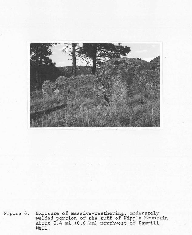
Figure 6. Exposure of massive-weathering, moderately welded portion of the tuff of Nipple Mountain about 0.4 mi (0.6 km) northwest of Sawmill Well.

of Nipple Mountain is a multiple-flow, simple cooling unit.
South of this study, evidence that the tuff of Nipple
Mountain is a compound cooling unit is the presence o f a
"turkey-track" andesite that is possibly interbedded with
the tuff (Chamberlin, 1974; Wilkinson, 1976).
In hand specimen, a trace to 15 percent of very
pale orange (IO YR 8 / 2 ) pumice are set in a light-gray (N 7)
to pale red-purple (5 RP 6 / 2 ) matrix. Samples from the
upper and lower portions of the unit contain faint, 1 mm
spheroids (cristobalite?). Less than 1 percent blocky,
sanidine and a few biotite flakes are seen in the rock.
Petrographically, the sanidine phenocrysts are anhedral to
subhedral and average 1 mm in longest dimension.
Plagioclase phenocrysts are present in trace amounts as
elongated to blocky subhedra with irregular embayments.
Traces of pleochroic, brown biotite and anhedral magnetite
are also present. Hematite occurs as an alteration product
of magnetite and as disseminated dust.
Sections from the lower portion of the tuff reveal
that the matrix is comprised of 85 to 90 percent
axiolitic-devitrified glass shards. The shards generally
wrap around phenocrysts and unbroken glass bubbles are
compressed to ellipses. About 10 percent of the thin
sections examined consist of minute, low-birefringent,
cherty-textured aggregates with undulatory extinction
(cristobalite?). One thin section from the top of the unit

38
consists of 80 to 85 percent cherty-textured masses,
averaging 0.006 mm in size, mixed with about 5 percent pore
space and 10 percent randomly oriented shards. The shards
are replaced by clear, polycrystalline aggregates with
undulose extinction and the groundmass is altered to
clay-size potassic minerals.
A thin section taken from a platy-weathering
horizon near the center of the tuff of Nipple Mountain is
comprised of partly devitrified shards set in a brown glass
matrix. The shards wrap around phenocrysts, and pumice
fragments are sufficiently compressed so that no pore space
remains. This densely welded section lacks cherty-textured
replacement products.
Where silicification o f the tuff is intense, the
groundmass is replaced by cherty silica and veinlets of
polycrystalline quartz that cut the fabric. Polycrystalline
quartz also occurs as cores in axiolitic-devitrified pumice.
Chamberlin ( 1 9 7 4 , p. 20) briefly discussed the propensity
for the groundmass constituents to be replaced by
cherty-textured silica in the tuff of Nipple Mountain; he
speculated that the tuff of Nipple Mountain "appears to have
been a preferrential channelway for hydrothermal solutions
and/or meteoric waters, because of its high initial
permeability." This is also a possible explanation for the
silicification of the tuff of Nipple Mountain in the
Gallinas Peak area. Alternatively, the cherty aggregates

39
seen in thin section, and the spherulites seen in hand
sample, may be the result of vapor-phase crystallization.
Where hydrothermally altered, the tuff of Nipple
Mountain becomes pale reddish brown (10 R 5 / 4 ) . Altered
surfaces have blackened patches of iron oxide, sometimes
with hematitic pseudomorphs of pyrite. Biotite flakes are
copper-colored and pumice fragments are darker red than the
matrix.
Upper Spears lavas and epiclastic rocks. A
distinctive sequence of lava flows intercalated with a few
coarse volcaniclastic horizons, comprises that portion of
the Spears Formation overlying the tuff of Nipple Mountain.
This unit of the Spears Formation crops out in two
north-trending belts in the central map area. The total
thickness of.the flows, as estimated from cross-sections,
averages 300 ft ( 9 1 m) but thickens to 560 ft (170 m) in the
west-central portion of the map area. This unit is missing
in the northern portion of the thesis area. The map pattern
of the contact of the upper Spears with the overlying Hells
Mesa Tuff suggests a conformable relationship between the
two units. Exceptions are the presence of relief on the
upper Spears in the vicinity of McGee Canyon, and the
absence of the upper Spears in the northern portion of the
thesis area.
40
In the vicinity of Three Log Spring Canyon, a
30-ft (9-m) sequence of sedimentary rocks, overlying the
tuff of Nipple Mountain, contains abundant white clasts of
that tuff in an orange, sandy matrix. A few widely
separated exposures of blue and gray to moderate
reddish-brown (10 R 4/6) argillaceous, coarse volcaniclastic
rocks are present in the upper member. Clasts are matrix
supported and the deposits generally lack internal
stratification; however, clasts are sometimes oriented in a
subparallel manner. Clasts range in size from sand-siee
grains to as large as 20 cm in diameter. Generally, the
clasts are latitic to andesitic and contain phenocrysts of
plagioclase and hornblende o r pyroxene. As no exposures of
hornblende-bearing latites are present in the upper member,
clasts bearing hornblende were probably derived from either
the lower member or from outside of the Gallinas Peak area.
The matrix of these coarse volcaniclastic rocks consists of
0.3 mm and smaller, chalky fragments of feldspar along with
silt- and clay-size particles. Textural similarities
between coarse volcanic rocks of the upper member and those
of the lower member suggest that these rocks are also
mudflow deposits.
An unconsolidated, pale yellowish-brown (10 YR
6/2), poorly sorted, immature, feldspathic volcanic arenite
is present on the southeast slope of Gallinas Peak.
Inspection with a binocular microscope reveals that the

4/2
are
eas
41
sediment consists of 40 to 50 percent, 2-cm to 1-ma
diameter, subangular to rounded volcanic fragments. Between
50 and 60 percent, 0.1 to 0 . 5 ma, angular, clear quartz and
chalky feldspar grains are also present. This
unconsolidated unit is probably the cause of the large slump
on the east side of Gallinas Peak.
Sparse occurrences of grayish red-purple ( 5 RP
) rhyolitic clasts with intensely contorted flow-banding
found in the southeastern portion o f the map area, just
t of hill "7906". These rhyolites are found only in
float and are not seen in outcrop.
Overlying the tuff of Nipple Mountain at two
localities in the northeast portion of the map area is a
brownish-gray ( 5 YR 4 / 1 ) to yellowish-brown (10 YR 6/2),
biotite-rich rhyodacite to quartz latite lava flow. A small
outcrop of a flow similar to this was also found in the
southern portion of the map area. A complete section of the
flow is not exposed in the Gallinas Peak area, but the
minimum thickness is about 80 ft (24 a). The flow locally
overlies 60 to 80 ft ( I 8 to 24 m) of loosely-consolidated
conglomerates o r mudflow deposits. Outcrops o f the flow
exhibit pronounced columnar jointing. The rock is well
indurated and gives a ringing sound when struck with a
hammer.
Megascopically, the flow consists of 0.3 to 0.5
ma, altered, subhedral to euhedral, prismatic plagioclase

4 2
phenocrysts that sometimes show preferred orientation. The
amount of plagioclase increases upward from 5 percent at the
base to about 20 percent. The plagioclase phenocrysts are
largely argillized, show some replacement by carbonate, and
readily weather out of the rock, leaving a rectangular hole.
Other phenocrysts present include 1 to 10 percent fresh, 2
to 3 mm, blocky to elongate sanidine and 2 percent, 0.5 to 2
mm, subhedral, bronzy biotite. Sparse lithic fragments are
similar in composition to the host rock and also show
alteration of the plagioclase.
A thin section of the rock shows conspicuous
alteration of the plagioclase to clay and calcite. Biotite
is pleochroic from deep-brown to red. Sanidine is partly
altered to clay. The matrix consists of glass, partially
devitrified to anhedral quartz crystals as much as 1 mm in
diameter; amall (0.004 mm), low-birefringent crystals of
sanidine and/or tridymite are also present. A crude flow
structure is enhanced by fine, hematitic bands.
The bulk of the upper Spears, above the tuff o f
Nipple Nountain, consists of "chocolate-chip"-textured,
pyroxene-bearing, basaltic andesites (fig. 7). Thick
sequences of these flows are present throughout the upper
Spears. The rock weathers to homogeneous, angular float of
porphyritic, medium light-gray (N 6 ) to moderate-brown ( 5 YR
3 / 4 ) clasts. Dark-green to red phenocrysts of pyroxene
impart a "chocolate-chip" texture to the clasts. On fresh

Figure 7. "Chocolate-chip"-textured andesite. Dark pheno- crysts are pyroxene. Photograph taken in Jaralosa Canyon, 0.6 m i (1.0 km) northwest of Sawmill Well.

44
surfaces, the phenocrysts are set in a uniform, grayish-red
(10 R 4/2) to black (N 1 ) matrix. Exposures of this
slope-forming unit are confined to arroyo and canyon walls.
Occasionally, monolithic flow breccias are found between
flows and near the top of the sequence. The clasts of the
flow breccia tend to lack pyroxene phenocrysts. Outcrops
sometimes exhibit columnar jointing (as near the mouth of
Three Log Spring Canyon). A crude to well-developed flow
foliation and some preferrential orientation of plagioclase
and pyroxene phenocrysts are also present. The flow
foliation varies in dip from subvertical to subhorizontal.
Elongate to blocky pyroxene phenocrysts, in amounts as much
as 2 percent, average 5 to 6 mm in length and are of two
varieties: a green-weathering type and a red-weathering
type. The green pyroxenes are as long as 1.4 cm and the red
pyroxenes are stubbier and usually less than 1 cm in length.
Phenocrysts of white to clear plagioclase as much as 2 mm
long comprise as much as 25 percent of a hand sample.
Microscopically, the plagioclase is anhedral to
euhedral, averages 0.5 to 0.6 mm in length, and has poorly
to'well-developed oscillatory zoning. The plagioclase
composition averages An63 (average of 1 4 measurements, from
6 thin sections, combined Carlsbad-Albite twin method;
range: 52 to 7 0 ) . Phenocrysts o f twinned, euhedral to
anhedral clinopyroxene, averaging 0.1 to 0.2 mm in size,
comprise from 1 to IO percent of any given thin section.

45
Orthopyroxene (probably hypersthene) is
subhedral, prismatic phenocrysts, usual
present as
ly smaller than the
clinopyroxene, and is sometimes enclosed by the more
abundant clinopyroxene. A glomeroporphyritic cluster of
clinopyroxene, biotite, and plagioclase was observed in one
thin section. Several red, altered pyroxene phenocrysts
seen in thin section are bordered by minute aggregates of
chlorite(?), hematite, and/or magnetite; the cores of these
phenocrysts are altered to hematite, polycrystalline quartz,
and sparse, shredded aggregates of chlorite(?). In a thin
section from the south portion of the map area,
clinopyroxene shows partial to complete alteration to an
intense green, chlorite-like mineral plus calcite, minor
polycrystalline quartz (with undulose extinction), and
magnetite. In the same thin section, portions o f the
plagioclase have been altered to calcite. In another thin
section, pyroxene was partly to completely replaced by
shredded masses of chlorite(?) and the remainder of the thin
section was unaltered.
The matrix of the flows, averaging about 70 to 75
percent of any given thin section, consists of felted, 0.01
to 0.04 mm microlites of plagioclase and magnetite usually
set in glass. Hematite is often disseminated throughout the
thin section, giving a brown color to the glass. Magnetite
is usually surrounded by a halo of hematite or is altered to
limonite. A trace of potassic-clays in the matrix and a

46
trace of corroded biotite with inclusions of magnetite are
found in some thin sections.
Wilkinson (1976), in the Tres Montosas-Cat
Mountain area, found flows in the upper Spears which
contained red-weathering pyroxene phenocrysts as much as 6.6
mm long. Similar "chocolate-chip"-textured, basaltic
andesites have been found in float of the Spears Formation
in an area 9 mi (14 km) to the west-northwest of the
Gallinas Peak area (G.C. Coffin, 1979, oral commun.). No
source vent for these flows was exposed in the Gallinas Peak
area. However, westward thickening of these flows to
greater than 500 ft (152 m) may reflect a possible buried
intrusive center near the western margin of the study area.
Hells Mesa Tuff
Tonking (1957) named the Hells Mesa Member of the
Datil Formation and measured a type section in the northern
Bear Mountains (sec. 31, T. 2N., R. 4W.). Chapin (1974a)
and Deal and Rhodes (1976) have since upgraded the Hells
Mesa Member to formational rank and restricted the Hells
Mesa Tuff to the crystal-rich, quartz-rich portion of
Tonking's original Hells Mesa Member. The Hells Mesa Tuff
was referred to as a rhyolite-porphyry sill by Loughlin and
Koschmann (1942) and was called the tuff of Goat Spring by
Brown ( 1 972).

47
The Hells Mesa Tuff has been recognized as a unit
of regional importance through geologic mapping in the
Gallinas, Bear, San Mateo, Magdalena, Chupadera, and L6mitar
Mountains, as well as east of the Rio Grande in La Joyita
Hills. Weber and Basset (1967) obtained a date of 30.6 2
2.8 m.y. using the K-Ar method on biotite from near the base
of the formation at Hells Mesa. In better agreement with
other dated units are the IC-AI: dates of 32.1 - + 1.5 m.y. and
32.4 - + 1.5 m.y. obtained on biotite from the Hells Mesa Tuff
in the Gallinas Mountains and La Joyita Hills by Burke and
others (1963). The Hells Mesa Tuff originated from the
North Baldy Cauldron in the Magdalena Mountains (Chapin and
others, 1978a).
The Hells Mesa Tuff usually conformably overlies
the Spears Formation in the Gallinas Peak area. This
relationship becomes unconformable in the northern portions
of the map area where the Hells Mesa directly overlies the
tuff of Nipple Mountain and the lower Spears. The Hells
Mesa Tuff also fills a palsovalley in the upper Spears near
the head of McGee Canyon. When the local dip on the Hells
Mesa is removed, the Spears Formation dips 1O0to the
northeast and the paleovalley strikes north. The Hells Mesa
is separated from the overlying A-L Peak Tuff by a thin
sequence of ash-flow and ash-fall tuffs. A local, thin
arkosic sandstone, bearing lithic fragments of the Hells
Mesa, is found at the top of the Hells Mesa Tuff in the
vicinity of Whiskey Well.

48
Chamberlin ( 1 9 7 4 ) , suggested a minimum thickness
of 800 ft (244 m) for the Hells Mesa Tuff at Gallinas
Springs, near the southern boundary of the Gallinas Peak
area. To the east of Jaralosa Creek, north of this study,
Mayerson ( 1 9 7 9 ) found the thickness of the tuff varied from
0 to a maximum of about 200 ft (61 m). About 1 2 mi (19 km)
northwest o f the Gallinas Peak area, Harrison (1979, oral
commun.) has found between 300 and 400 ft (91 to 122 m) of
Hells Mesa. In the southern portion of this study area,
cross-sections indicate a thickness for the Hells Mesa Tuff
of 650 ft ( 1 9 8 m). In the northwestern portion of the
Gallinas Peak area, the thickness of the tuff decreases to
about 350 ft ( 1 0 7 m). Thin remnants of the Hells Mesa along
the piedmont escarpment to the northeast of the study area
suggest that, in this region, the unit was deposited in
localized channels.
Outcrops of the Hells Mesa Tuff are usually
prominent cliffs with crude columnar jointing (fig. 8);
talus from these cliffs conceals the contact with the
underlying Spears Formation. In good exposures, the
relatively pumice-rich basal horizons, which break easily
into thin, slabby chunks, grade sharply upward into
well-indurated, pumice-poor horizons.
Lithic fragments in the Hells Mesa Tuff are common
locally near the base of the section, but are rare overall.
Usually, the lithic fragments are purple to gray, aphanitic,

Figure 8. Crudely developed columnar j o i n t i n g i n the Hells Mesa Tuff. Note a l so c rude j o in t ing developed para l le l to subhor izonta l cornpac- t ion fo l ia t ion . Photo t aken about 770 f t (235 m) southwest o f Sawmill Well.

50
subangular to rounded, and less than 1 cm in greatest
dimension; they normally have phenocrysts of feldspar and
altered ferromagnesian minerals. Elongate lithic fragments
are oriented in the plane o f compaction foliation. Most of
the lithic fragments are probably derived from the Spears
Formation. Variations in clast content, pumice content, and
mineralogy suggest that in the Gallinas Peak area, the Hells
Nesa is a multiple-flow, simple cooling unit.
Megascopically, specimens from the base of the
Hells Mesa vary in color from medium gray (N 5) to light
brownish gray (5 YR 6 / 1 ) and contain 10 to 15 percent,
flattened, creamy-white pumice. Glassy, blocky, feldspar
phenocrysts, averaging 0.5 mm in length, comprise about 2 5
percent of the basal portion of the tuff. A trace of quartz
and 2 percent, euhedral, black to bronzy biotite are also
present.
Commonly, within a few feet of the base of the
unit, a moderate-brown ( 5 YR 3/4 to 5 YR 4/4) vitrophyre, as
much as 12 ft (4 m) thick, is present. The vitrophyre
contains about 25 percent feldspar phenocrysts, a trace of
quartz, and 2 to 3 percent bronzy to black biotite. Pumice
fragments are compressed into black, homogeneous glass
(piperno) and are set in an aphanitic matrix.
Samples from the middle of the unit are pale red
( I O R 6/2), contain 50 to 35 percent phenocrysts, and have 5
percent or less pumice. Quarts anhedra, as much as 3 mm in
r

5 1
greatest dimension, are usually rounded and make up 5 to 10
percent of any given sample. Feldspar grains are blocky,
partly rounded subhedra and have a glassy to chalky luster.
Biotite flakes are black to bronzy, are present in trace
amounts, and are often crudely arranged parallel to the
compaction foliation. Rarely, glass shards can be
distinguished wrapping around phenocrysts in hand sample.
The top of the Hells Mesa is moderate brown ( 5 YR
3 / 4 ) , lacks pumice, and contains as much as 20 to 25 percent
quartz. The clear to black (smokey) quartz anhedra are
angular to well rounded, and as much as 3 mm in diameter.
Glassy feldspar grains comprise about 15 percent of a hand
sample, and biotite flakes are present in trace amounts.
Petrographically, the groundmass of the Hells Mesa
Tuff is glass which has largely devitrified to
low-birefringent crystals barely discernable from the
groundmass. Pumice fragments, when present, are often
devitrified to axiolites of low or moderate birefringence.
The fibrous texture of unaltered pumice fragments is often
enhanced either by incipient crystals, or by finely
disseminated hematite. The pumice fragments are warped
around phenocrysts and compressed s o that no pore space
normally remains. Glass shards are rare; when present, they
can be seen to bend around phenocrysts. The Hells Mesa Tuff
is densely welded throughout.

Although feldspar phenocrysts sometimes appear
euhedral in hand sample, thin sections reveal they have been
comminuted to anhedral and subhedral grains. Additionally,
feldspar and quartz grains are often rounded. In some thin
sections, pumice and trains of broken crystals are squeezed
between phenocrysts. Subhedral to euhedral biotite,
pleochroic in greens, reds, and browns, is often bent to
partially conform to the surface of adjacent crystals.
Euhedral to subhedral, pleochroic (from dark-brown to
yellow) amphibole is usually present in trace amounts.
Anhedral magnetite is a common accessory constituent.
Plagioclase is the dominant phenocryst near the
base of the Hells Mesa Tuff, where it can make up 25 to 30
percent of the rock. The top of the formation, however,
contains 5 to 10 percent sanidine and less than 5 percent
plagioclase. Plagioclase grains sometimes show oscillatory
zonation or strong normal zonation. The composition o f the
plagioclase from the bottom of the unit is about An34 (2
measurements, combined Carlsbad-albite twin method; averaged
with the maximum value from 8 measurements, Michel-Levy
method; range: 32 to 39). In a thin section from within 5
ft ( 1 . 5 m) of the top of the unit, the plagioclase has a
composition of about An37 (maximum value from 1 1
measurements, Michel-Levy method).
The Hells Mesa Tuff acquires a dark
yellowish-orange ( IO YR 6/6) to light olive-brown (5 Y 5/6)

53
color where hydrothermally altered. Sometimes, the only
indications of alteration seen in hand specimen are the
chalky appearance of the feldspars and their slight
effervescence in HC1. Thin sections of altered Hells Mesa
Tuff show that many plagioclase grains are partly replaced
by patches of calcite and chlorite. Where the alteration is
more intense, plagioclase is partly replaced by chlorite and
epidote(?), and amphibole is altered to limonite and
hourglass-shaped aggregates of chlorite. Disseminated
limonite and hematitic pseudomorphs o f pyrite are found in
the groundmass. Polycrystalline quart5 ireinlets are
sometimes found in these altered portions of the tuff.
A-L Peak Tuff
The A-L Peak Rhyolite was named by Deal and Rhodes
( 1 9 7 6 ) for a 2000 ft ( 6 1 0 m) section on A-L Peak in the San
Mateo Mountains, 24 mi (39 km) south of the Gallinas Peak
area. Deal and Rhodes proposed that the tuff was erupted
from a cauldron located in the San Mateo Mountains. Smith
and others ( 1 9 7 6 ) , using the fission-track technique,
obtained an age of 31.8 - + 1 .7 m.y. on a sample collected
near A-L Peak in the San Mateo Mountains. Regional mapping
in the Socorro-Magdalena area indicates that the A-L Peak is
comprised of three distinct members. Mapping in the
Magdalena Mountains, 28 mi (45 km) southwest of the thesis
area indicates that probably all three of these members

5 4
originated from cauldron sources in the southern Magdalena
Mountains (Chapin and others, 1978a,b). Thus, Deal and
Rhodes' type-section may not be representative of, or even
the equivalent of, the A-L Peak as presently mapped in this
and other parts of the Socorro-Magdalena area.
The A-L Peak Rhyolite was renamed the A-L Peak
Tuff by Chapin and others (1978a, p. 117). Equivalent,
older terminology used in the Magdalena area includes the
"banded rhyolite" of Loughlin and Koschmann (1 942), the
middle portion of Tonking's (1957) Hells Mesa Member, and
the tuff of Bear Springs of Brown (1972).
In the Gallinas Peak area, outcrops of the A-L
Peak Tuff are found in a southwesterly dipping band on the
area's western margin and in scattered remnants on the
area's northeastern margin. The tuff consists of an upper
and lower cooling unit with a combined thickness of about
785 ft (239 m). The lower cooling unit consists of two
members (Chapin and others, 1978b): a basal gray-massive
member, and an overlying, flow-banded member. The upper
cooling unit is called the pinnacles member for its
characteristic outcrop appearance. South of the study area,
Chamberlin (1974) described three cooling units in the A-L
Peak; his lower cooling unit represents the lower and upper
cooling units described in this study. The mafic lavas and
upper two cooling units in the west portion of Chamberlin's
(1974) study area are now known t o be equivalent to the

5 5
basalts of Jones Tanks and Antelope Flats, and the tuff of
South Canyon of this study. The mafic lavas lie entirely
above the A-L Peak Tuff south of the southwest portion of
this study area (G.R. Osburn, 1980, oral commun.). A
sequence of mafic lavas which often separates the
flow-banded member from the pinnacles member elsewhere in
the Socorro-Magdalena area, is present as thin,
discontinuous outcrops found only in the northeastern
Gallinas Peak area (basalt o f Jones Tanks).
A thin sequence of ash-flow and ash-fall tuffs,
herein described as "Lower Tuffs", is present at the base o f
the A-L Peak Tuff. These tuffs are mapped with the A-L Peak
Tuff because of a mutually similar phenocryst composition
and phenocryst abundance.
Lower Tuffs
In the thesis area, a thin sequence o f poorly
welded, moderately crystal-poor, ash-flow and ash-fall tuffs
normally separates the lower cooling unit from the Hells
Mesa Tuff (fig. 9). At the base of this sequence is a
poorly welded, pumice-rich zone, 1 to 2 ft (0.3 to 0.6 m)
thick. In hand specimen, 5 to 10 percent, small ( 1 to 10
mm), slightly compressed pumice fragments are set in a
grayish orange-pink ( 5 YR 7 / 2 ) to pale red-purple ( 5 RP 6/2)
matrix. Clear, subhsdral, 1 mm phenocrysts of sanidine
comprise 2 to 3 percent of any given hand sample. One to

Figure 9 . Conformable contact between the Hells Mesa Tuff and an overlying, thin sequence of t u f f s . Break i n s l o p e a t r i g h t background i s the gray-massive member of the A-L Peak Tuff ( a r r o w ) . Photo taken at head of Three Log Spring Canyon.

two percent, 1 mm quartz anhedra are also present. Most of
the pumice fragments contain minute (less than 0.5 mm)
spherulitic aggregates, and portions of the groundmass also
contain minute spherulites. Yellow and black staining of
the matrix and pumice is sometimes found. Sparse,
subrounded to rounded, mafic rock fragments, less than 1 cm
in diameter are also found in hand specimen.
Overlying the poorly welded tuff is a thinly
bedded, moderately indurated, ash-fall tuff. This horizon
is usually about 1 ft (0.3 m) thick and consists of 0.5 cm
to 3 cm, pinkish-gray (5 YR 8 /1 ) , planar beds. Subhedral to
anhedral sanidine, averaging less than 1 mm comprises less
than 1 percent of the rock. Anhedral to euhedral,
dipyramidal quartz is slightly more abundant than sanidine
and averages between 0.5 and 1 mm in size. Minute grains of
a ferromagnesian mineral, altered to hematite, dot the
aphanitic matrix.
The ash fall is overlain by a poorly welded,
pumice-rich, pinkish-gray ( 5 YR 8/1) ash-flow tuff. This
tuff is 1 to 3 ft (0.3 to 0.9 m) thick and contains 3 to 5
percent, clear, quartz anhedra, about I mm in diameter.
Subhedral sanidine is about the same as quartz in size and
abundance. Fibrous, crudely oriented pumice fragments, as
much as 1 cm in length comprise about 1 5 percent of the
rock. The tuff contains sparse, pink, rounded, aphanitic
lithic fragments that average about 5 mm in diameter.

Patches of black, oxide coa
specimen. Petrographically
tings are common in hand
, shards have a general random orientation and unbroken glass bubbles are uncompressed,
although some shards wrap around phenocrysts. The shards
are devitrified to axiolites of low to moderate
birefringence, and the groundmass is devitrified to
microlites. Prismatic sanidine phenocrysts are sometimes
slightly bent and have undulose extinction.
A pale-red ( 5 R 6/2), poorly welded, crystal-poor,
ash-flow tuff several feet thick is present overlying the
more pumice-rich, crystal-rich ash-flow tuff. In hand
specimen, slightly compressed, creamy-white pumice
fragments, as much as 4 cm long comprise about 5 percent of
the rock. One to two mm, glassy sanidine phenocrysts
account for about 1 percent of the rock. Anhedral quartz,
slightly smaller than sanidine, is present in trace amounts.
In thin section, some of the sanidine has been strained,
imparting a wavy extinction to the grains. Trace minerals
include anhedral plagioclase, and euhedral amphibole partly
replaced by chlorite and hematite. Glass shards are
slightly bent around phenocrysts, but unbroken glass bubbles
remain circular. The randomly oriented shards are set in a
groundmass that is stained red by disseminated hematite.
Shards show some axiolitic devitrification. The fibrous
nature of the pumice is enhanced by its partial
devitrification.

5 9
These thin tuffs overlying the Hells Mesa are of
uncertain origin, but may represent an early eruptive phase
of the A-L Peak Tuff. G.R. Osburn (1979, oral commun.) has
found similar tuffs in the area adjacent to the northwest
boundary of the Gallinas Peak area.
Lower Cooling Unit
In the Gallinas Peak area, the lower cooling unit
of the A-L Peak Tuff is a multiple-flow, simple cooling unit
of poorly to densely welded, crystal-poor, pumice-poor to
pumice-rich, rhyolite ash-flow tuffs. The lower cooling
unit c o u l d have been mapped as two distinct members: a
lower, gray-massive member, and an upper, flow-banded
member. These members are thought to be erupted from the
Magdalena cauldron, or, in part, from the Sawmill Canyon
cauldron in the Magdalena Mountains (Chapin and others,
1978a,b; Both, 1980). A thin sequence of ash-flow and
ash-fall tuffs (Lower Tuffs, p. 55) normally separates the
gray-massive member from the underlying Hells Mesa Tuff in
the thesis area. The pinnacles member of the A-L Peak
conformably overlies the flow-banded member in the
southwestern portion of the thesis area, but is separated
from the flow-banded member by a thin sequence of mafic
lavas in the northeastern Gallinas Peak area.
Cross-sections indicate a thickness of about 510
ft (155 m) for the lower cooling unit in the west portion of

60
the study area. In the northeast portion of the Gallinas
Peak area, thin remnants of.the lower cooling unit are
present at the base of a piedmont escarpment. At one place
in this vicinity, these tuffs occupy a channel cut into the
lower Spears; at another locality, they are in fault contact
with the Baca. Along the western margin of the thesis area,
the lower cooling unit caps the gentle, southwesterly
dipping slopes overlooking the Plains of San Augustin.
Hydrothermal alteration in the lower cooling unit
is rare. Near the western boundary of the map area, in an
arroyo along the border of the Plains of San Augustin
(SW1/4, sec. 12, T. IS, R. 7W), an exposure of the tuffs was
coated with a dull black material which gave a
greenish-black streak. No brecciation was seen in the
vicinity of this outcrop. In the extreme southwestern
portion of the map area, the pumice fragments in the
gray-massive member are darkened gre'enish black to black and
the matrix is unaltered. This alteration is in the vicinity
of a northwest-trending fault and may bear a genetic
relation to the fault.
Gray-massive member. The pumice-poor,
crystal-poor, gray-massive member forms an unmistakable
break in slope at its contact with the thin, underlying,
less resistant ash-flow and ash-fall tuffs (fig. 9) . The
topographic break is usually small; however, near the border
of the Plains of San Augustin, 10 to 20 ft ( 3 to 6 m) cliffs

6 1
of the gray-massive member are sometimes present. In the
southwest portion of the map area, the maximum thickness for
the gray-massive member is estimated to be 300 ft (91 m).
In fresh hand specimens, the gray-massive member
consists of sparse, glassy to chatoyant sanidine
phenocrysts, averaging about 1 mm in length, set in a very
light-gray (N 8) matrix. Pumice fragments are rare near the
base of the member, but lenticular-shaped pumice fragments,
slightly darker than the matrix, increase in abundance
toward the top of the member. Rare, sub-rounded, andesitic
fragments are also present. Petrographically, between 1 and
2 percent, prismatic to blocky sanidine phenocrysts are set
in a matrix of axiolitic-devitrified glass shards. Unbroken
glass bubbles are slightly flattened and the shards are
preferentially oriented, bending slightly around
phenocrysts. Traces of anhedral plagioclase and magnetite,
as well as euhedral, altered amphibole are also present.
The amphibole is mostly replaced by magnetite and encloses
biotite(?).
Flow-banded member. Overlying the gray-massive
member, and welded(?) to it (or possibly gradational with
it), is the densely welded., crystal-poor, flow-banded
member. The estimated maximum thickness for the flow-banded
member is 210 ft ( 6 4 m). The flow-banded member caps gently
sloping ridges in the southwest and west portion of the
thesis area. Outcrops in the northeastern Gallinas Peak

6 2
area are generally poorly exposed along a piedmont
escarpment, because of the thin, discontinuous nature of the
unit in this vicinity. In decreasing order of abundance,
the most prominant primary flow-features seen in outcrop are
lineated pumice, broad flow-folding, and rotated, welded
inclusions of the preceeding flow. Flattened, lineated
pumice fragments are characteristic of the flow-banded
member; thier linear nature becomes less obvious toward the
upper portions of the flow and in the northwestern portion
of the thesis area. The average trend of these linear
features, when the regional strike and dip is removed, is N
16'W (taken' from a total of 10 measurements, visually
averaged from a stereographic plot). Schmincke and Swanson
(1967) have shown that such lineations are the result of
primary laminar flowage, and that the lineations parallel
the flow direction of the tuff, away from its source. In
the Council Rock area, Chamberlin (1974, p.36) found
lineations which varied from N 8"W to N ?E.
Broad flow-folds in the flow-banded member are
also found in the thesis area. These folds are poorly
exposed and are often expressed as local aberrations in the
strike and dip of compaction foliation. The axial planes of
the folds are sub-parallel to the average trend of the
pumice lineations. These are considered to be the result of
minor adjustments of the ash flow which occurred after
movement of the flow as a unit ceased. Chamberlin (1974)

63
describes primary flow-folds in the flow-banded member in
the Council Rock District; he found the axial planes of the
primary flow-folds to be roughly perpendicular to the pumice
lineations.
Wildly contorted compaction foliation, surrounding
densely welded fragments from the same member, were seen at
one outcrop (fig. IO). The fist-size fragments are rotated
s o that their compaction foliation is almost perpendicular
to that of the surrounding matrix. The matrix is partially
draped around, and leaves cavities on either side of the
inclusions. As both the inclusion and matrix are densely
welded, the inclusions could have been ripped up from the
underlying flow during initial emplacement o f the subsequent
flow, but only after much compaction had taken place.
Schmincke and Swanson ( 1 9 6 7 ) have described similar
features, except that the inclusions were poorly welded
tuffs o r xenoliths; they interpreted the features as'
structures produced during initial emplacement of the tuff.
In fresh hand specimens of the flow-banded member,
1 to 3 percent, euhedral to anhedral, glassy sanidine
phenocrysts are set in a moderate-brown (5 YR 3/4) to
light-gray (N 7 ) matrix. Quartz anhedra, less than 1 mm in
diameter account for 1 percent o r less of the tuff. Pumice
fragments range from intensely flattened and lineated in the
lower and middle portions, to discoid and open in the upper
portion of the unit. Small (1 to 4 mm), subrounded to

Figure 10. Rotated, welded inclusions in.an intensely
member of the A-L Peak Tuff. Photo taken contorted, welded matrix of the flow-banded
about 0 . 4 mi (0.6 km) south of the head of I Three Log Spring Canyon.

65
rounded mafic rock fragments are present in amounts of as
much as 1 or 2 percent in some samples.
At the top of the flow-banded member is a
semicontinuous, moderately welded zone 0 to 10 ft ( 3 m)
thick. The phenocryst content is similar to the rest of the
unit, but its chocolate-brown color and massive appearance
make it a distinctive horizon. Fresh hand specimens have
euhedral to anhedral sanidine phenocrysts set in a pale
yellowish-brown ( I O YR 6 / 2 ) to pale-red matrix ( I O R 6 / 2 ) .
Pumice fragments are less abundant and smaller than in the
rest of the flow-banded member.
Microscopic examination of the lower cooling unit
shows that 0.1 to 2 mm sandine crystals are usually fresh,
but sometimes have a cellular texture and wavy extinction.
Euhedral amphibole, shredded biotite, magnetite, and
anhedral plagioclase are present in trace amounts. One
xenocryst o f euhedral microcline was seen. Traces of quartz
are also present; one quartz anhedra, about 1 mm in
diameter, was strongly embayed.
In thin sections from the basal and middle
portions of these tuffs, the original shard texture has been
almost completely destroyed as a result of devitrification
of the groundmass to minute (less than 0.01 mm diameter)
cristobalite(?) and sanidine crystals. Intensely flattened
pumice fragments bend slightly around phenocrysts, and are
devitrified to axiolites surrounding spherulitic cores and

6 6
interlocking arrays of low-birefringent crystals. Some
pumice fragments include cellular to fresh sanidine
phenocrysts. In one thin section, (from a sample near the
middle of the flow) arcuate structures (perlitic cracks?)
clouded by limonitic dust, pervade the groundmass.
In thin sections from the upper portion of the
unit, the shard structure is retained and the pumice is not
intensely flattened; however, the compaction foliation is
still obvious from the parallel arragement of glass shards
and pumice. In all thin sections from the flow-banded
member, the matrix is pervaded by fine hematitic dust.
Upper Cooling Unit
Pinnacles member. The pinnacles member of the A - L
Peak Tuff is separated from the flow-banded member by a
pronounced cooling break, and is the youngest cooling unit
of the A-L Peak Tuff (Chapin and others, 1978a,b). This
upper cooling unit is a multiple-flow simple cooling unit of
poorly to densely welded, crystal-poor rhyolite tuffs.
These tuffs are thought to have originated from the Sawmill
Canyon cauldron in the Magdalena Mountains (Chapin and
others, 1978a,b).
The pinnacles member of the A - L Peak Tuff is
poorly exposed along the piedmont escarpment in the
northeastern Gallinas Peak area. Here, outcrops are
separated from the underlying flow-banded member and from an

67
overlying sequence of rhyolite tuffs by thin, mafic lava
flows. In the southwestern Gallinas Peak area, the
pinnacles member conformably overlies the flow-banded member
and is overlain by a thick sequence of basalts and coarse
sedimentary rocks. Here, these tuffs crop out over about a
0.5 sq mi ( 1 . 3 sq km) area and have a maximum estimated
thickness of 275 ft (84 m). Faulting in this region has
placed the pinnacles member in contact with the Hells Mesa
Formation, the flow-banded member, and the overlying
sedimentary rocks, lavas and tuffs.
The pinnacles member is usually well indurated,
but outcrops are normally low, unimposing ledges. Float of
chips and blocks usually forms a coarse mantle on the
southwesterly dipping slopes in the vicinity of Whiskey
Well.
At the base o f the pinnacles member is a thin,
pinkish-gray to grayish orange-pink ( 5 YR 8/1 to 5 YR 7/2),
poorly welded horizon. A topographic bench is usually
present along the contact of these basal tuffs and the
underlying, densely welded tuffs of the flow-banded member.
Hand samples of the poorly welded tuffs usually contain 10
to 15 percent, angular, randomly oriented pumice fragments,
1 to 20 mm in diameter. Phenocrysts in these poorly welded
tuffs are sparse ( 1 percent o r less); sanidine is the
dominant phenocryst, and quartz is present in lesser
amounts. Lithic fragments are locally abundant, sometimes

comprising about 40 percent of any given hand sample. The
lithic fragments include silcified clasts of a banded
rhyolite, silicified clasts of the Hells Mesa Tuff, red to
black andesitic clasts, and gray, cherty, lithic fragments
(fig. 1 1 ) . The angular to subangular, silicified rhyolite
clasts are dark-gray and contain sparse phenocrysts of
quartz and sanidine. A rhyolite lava flow similar in
composition to these rhyolite clasts was found by G . R .
Osburn (1979, oral commun.) south of the southwestern
Gallinas Peak area near Lion Mountain.
Fresh hand samples of the pinnacles member, above
its poorly welded base, are very light gray to pale
yellowish brown (N 8 to 10 YR 6/2), and contain about 1 'to 7
percent euhedral to subhedral, glassy to chatoyant sanidine
phenocrysts, and a trace of anhedral quartz. Pumice
fragments are moderately flattened, comprise 5 to 15 percent
of the rock, and are devitrified to fine, botryoidal and
granular masses s o that the original pumice texture is
rarely preserved (fig. 1 2 ) .
Microscopic study of the pinnacles member reveals
that, although sanidine appears euhedral in hand specimen,
it usually appears anhedral o r subhedral in thin section.
The 0.05 mm to 3 mm long sanidine phenocrysts sometimes have
a cellular texture and large quartz-filled embayments.
Traces of anhedral quartz, altered biotite, amphibole, and
pyroxene are seen in thin section. The biotite, amphibole,

Figure 11. Lithic-rich basal portion of the pinnacles member of the A-L Peak Tuff. Clasts are dominantly comprised of the Hells Mesa Tuff
670 ft (240 m) southwest of W'iskey Well. ' and a banded. rhyolite. Location is about

Figure 12. P a r t i a l l y compressed pumice f r agnen t s i n p-innacles member of the A-L Peak Tuff about 930 f t (283 m) southwest o f Whiskey Well.

71
and pyroxene are partly replaced by hematite-stained
magnetite. One thin section from near the top of the unit
contains about 1 percent anhedral magnetite as much as 0.5
mm in diameter. Axiolitic- and spherulitic-devitrified
pumice fragments are present in thin sections from the lower
half of the pinnacles member. The spherulites usually
enclose irregular and bladed aggregates of cristobalite(?)
and cellular sanidine. In contrast, pumice.fragments from
the upper half of the member lack spherulites and are
devitrified to axiolites and interlocking arrays of sanidine
and cristobalite(?). In the lower portion of the tuff,
glass shards are strongly deformed to conform to the edges
of phenocrysts and are devitrified (in part) to fine (0.05
mm or less) masses o f sanidine and cristobalite(?). Thin
sections from the moderately to poorly welded upper portion
of the member generally show less shard distortion. The
shards are partly devitrified to very fine (about 0.002 mm
long), low-birefringent axiolites. The groundmass in
sections from near the top of the unit is devitrified to
0.004 to 0.03 mm interlocking arrays of quartz and sanidine.
Fine, hematite dust enhances the shard structure in most
thin sections. Two lithic fragments seen in thin section
were comprised of plagioclase and ferromagnesian minerals.
The ferromagnesian minerals had been extensively replaced by
magnetite and quartz.

Mafic Lavas and Sedimentary Rocks
Mafic lavas overlie the pinnacles member of the
A-L Peak in two widely separated portions of the Gallinas
Peak area. The lavas are exposed along the northeastern
border. of the map area, northeast of Jones Tanks, and in the
southwest portion of the area, north of Antelope Flats.
Minor exposures are also found southeast of Antelope Flats.
The lack of continuous exposure of these lavas from Jones
Tanks to Antelope Flats makes correlations impossible;
however, petrographic study indicates that the flows are of
similar composition.
Basalt of Jones Tanks
Flows of basaltic composition crop out along the
piedmont escarpment in the northeastern portion of the
thesis area. Here, the thin, erratic distribution and
discontinuous nature of the lavas, with respect to the
underlying A-L Peak Tuff, suggest that the lavas were
deposited in channels cut into the older tuffs. At two
localities northeast of Jones Tanks, the basalts separate
the pinnacles member from the flow-banded member of the A-L
Peak Tuff. Outcrops of these lavas are usually small
exposures partly concealed by colluvium shed from the
overlying piedmont gravels.

73
In fresh hand specimens, 2 to 3 percent hematitic
pseudomorphs of olivine and pyroxene, and 1 to 2 percent
green phenocrysts of pyroxene are set in a medium-gray (N 5)
matrix. The phenocrysts average between 0.5 and 1.0 mm in
length. Almond-shaped vesicles are present in some
specimens.
Thin section analysis reveals that two types of
phenocrysts and microlites of pyroxene are present: euhedral
hypersthene, and subhedral clinopyroxene. Prismatic
hypersthene phenocrysts, averaging about 0.6 mm in length,
are altered to hematite and lesser amounts of minute (less
than 0.002 m u ) , low-birefringent aggregates, and are rimmed
by magnetite grains. Green phenocrysts of clinopyroxene,
averaging approximately 0.2 mm in length, are about twice as
abundant as hypersthene, and are usually embayed and
cellular. Olivine euhedra and subhedra account for about 2
percent of the thin section examined, and are altered to
hematite and 0.002 mm and less, low-birefringent aggregates.
An estimate of the groundmass composition is: 50
to 55 percent, 0.1 mm or smaller, labradorite laths
(composition is about An60, maximum value out of 7
measurements, Michel-Levy method); approximately 30 percent
green, 0.002 mm to 0.01 mm long, clinopyroxene microlites,
about 1 percent yellow, 0.02 mm long, laths of hypersthene;
and about 1 5 percent anhedral grains of magnetite. Many of
the clinopyroxene microlites are enclosed by plagioclase;

some of the magnetite may be an alteration product of
olivine. Occasionally, small irregular carbonate patches
replace the plagioclase.
Basalt and Sedimentary Rocks of Antelope Flats
Overlying the pinnacles member of the A-L Peak
Tuff in the southwestern Gallinas Peak area is a thin
sequence (about 180 ft, 55 m) of basalt flows and
intercalated sedimentary rocks. Exposures are confined to
small, slope-forming, rubbly outcrops both north and-
southeast of Antelope Flats. The lava flows consist of
pale-brown ( 5 YR 5 / 2 ) to medium-gray (N 5) basalt flows
which have from 5 to 20 percent, irregular- to almond-shaped
vesicles as much as 20 mm long. The vesicles usually have a
preferential orientation, and are sometimes filled with
calcite. One vesicle lineation had a bearing of N 32"W
after removing the regional dip of the flows. Hand samples
of these flows sometimes contain several percent olivine and
clinopyroxene phenocrysts, as much as 1 mm long, which are
altered to hematite. Sparse phenocrysts of plagioclase are
also seen in some hand samples.
,,
Petrographic analysis of these lavas shows that
from 7 to 10 percent, anhedral to euhedral clinopyroxene
crys'tals are present. These crystals average between 0.05
and 1 mm in length, and are sometimes twinned. Anhedral to
euhedral, 0.02 to 0.5 mm olivine phenocrysts account for

75
between 1 and 5 percent of any given thin section. Some of
the olivine is partially altered to, or encloses, magnetite.
Portions of the olivine crystals contain patches of hematite
along with a brown, opaque material, and low-birefringent,
needle-like crystals (antigorite?). Out of two thin
sections examined from these basalts, one contains about 15
percent, euhedral to subhedral (rarely anhedral), 0.5 to 1.3
mm plagioclase phenocrysts with randomly oriented, 0.02 to
0.2 mm groundmass plagioclase. A few of the plagioclase
phenocrysts are normally zoned. A second thin section
contains 70 to 80 percent, pilotaxitic plagioclase having a
continuous range in size from about 0.05 to 0.5 mm.
Plagioclase phenocryst and microcryst compositions indicate
that these flows are probably basalts. In the thin section
with both phenocryst and groundmass plagioclase, the
groundmass plagioclase had a composition of about An58
(maximum value from 1 4 measurements, Michel-Levy method);
the phenocryst plagioclase averaged An74 (average of two
measurements, combined Carlsbad-albite twin method, range:
An67 to An81). In the second thin section, plagioclase
averaged An74 (average of two measurements, combined
Carlsbad-albite twin method, range: An72 to An76). Each
thin section contains from 3 to 5 percent magnetite anhedra
in a glassy groundmass which turns brown in reflected light.
Intercalated with the basalts are sedimentary
rocks which consist of poorly to well-indurated, medium- to

76
thick-bedded sandstones and sandy conglomerates (fig. 1 3 ) .
These sedimentary rocks are poorly exposed, but some
outcrops are found on hillslopes where colluvium and talus
have been stripped away. The sandstones were not studied in
detail, but estimates using a hand lens suggest they are
fine- to medium-grained, and moderately to poorly sorted,
immature litharenites to feldspathic litharenites. Some
samples are possibly sublitharenites and lithic arkoses.
The sandstones and conglomeratic sandstones contain lithic
fragments which range from fine sand to cobble size (0.2 mm
to about 90 mm). Lithic fragments, in order of abundance,
include purple t o black andesites(?); gray, silicified,
flow-banded rhyolite; and red, silicified chips from the Abo
Formation. The rhyolite fragments are similar to the
rhyolite clasts described in the pinnacles member, and f o u n d
by G.R. Osburn (1979, oral commun.) south of the thesis
area. The sparse occurrence of the Abo clasts suggests that
either a topographic high of the Abo existed locally during
deposition of this sedimentary unit, or that the clasts are
reworked clasts derived from an earlier period of erosion.
Wilkinson (1974, p. 12) found the Abo Formation
unconformably overlain by the Spears Formation south of
Antelope Flats, in the vicinity of Tres Montosas. Provided
that a topographic high of the Abo Formation still existed
in the Tres Montosas area during deposition of these
post-A-L Peak Tuff sedimentary rocks, that area could have
been a source for these clasts.

Figure 13. Sandy conglomerates and sandstones of the sedimentary rocks of Antelope Flats. Here, clasts are mostly banded rhyolite, but rock fragments of the Ab0 Formation are locally abundant. Photo taken about 0.6 mi (1.0 km) southwest of Whiskey Well.

Tuff of South Canyon
The tuff of South Canyon was named by Osburn
(1978, p. 4 9 ) for a measured section of crystal-poor to
moderately crystal-rich ash-flow tuffs located at the mouth
of South C.anyon in the Magdalena Mountains, about 26 mi (42
km) southeast of the Gallinas Peak area. A K-Ar age of 26.2
+ 1.0 m.y. was obtained on biotite from a sample of the
same tuff from the Joyita Hills (Osburn, 1978, p. 4 9 ) .
-
Exposures of the tuff of South Canyon have been
mapped in the Magdalena, Chupadera, and Lemitar Mountains
the Joyita Hills, east o f this thesis area, and on Lion
Mountain, southwest of this study (G.R. Osburn, 1979, oral
commun.). Similarities in crystal content, weathering
characteristics, and welding suggest that the tuff of South
Canyon is equivalent t o Chamberlin's (1974, p. 41 to 45)
middle and upper cooling units of the A-L Peak Formation in
the western portion of the Council Rock area, just south of
this study. In the Gallinas Peak area, the tuff of South
Canyon, is a multiple-flow, simple cooling unit, and crops
out in the southwest corner of the map area in two, low,
south- to southwest-sloping ridges. These tuffs conformably
overlie the basalt flows and sedimentary rocks of Antelope
Flats and are conformably overlain by a thick sequence of
andesites. An abrupt break in slope is present between a
poorly indurated, crystal-poor, creamy-white to brownish
zone at the top of the tuff of South Canyon and the
overlying andesites.

A minimum thickness of 570 ft ( 1 7 4 m) and a
maximum thickness of 965 ft ( 2 9 4 m) was estimated for the
tuff of South Canyon from exposures in the southwest portion
of the map area. Thin, discontinuous exposures of the tuff
of South Canyon are found along the piedmont escarpment.in
the northeast portion of the map area. The outcrop pattern
suggests that these tuffs were emplaced upon an irregular
surface in the area northeast and southeast of Jones Tanks.
The tuff of South Canyon can be divided into two
mappable members in the Gallinas Peak area: a crystal-poor
lower member, and a thinner, moderately crystal-rich, upper
member. The lower member is a platy-weathering, moderately
to densely welded sequence of ash flows, and the upper
member is a blocky-weathering, moderately to poorly welded
sequence of ash flows (fig. 1 4 ) . No cooling break was
recognized between these members by the author.
Lower Member
The lower member of the tuff of South Canyon is
estimated to have a minimum thickness of 355 ft (108 m), and
a maximum thickness of 600 ft (183 m) in the southwest
corner of the study area. A thin, vitric horizon, which
sometimes has columnar jointing, is usually present at the
base of the lower member of the tuff of South Canyon. This
vitrophyre is usually medium dark gray (N 4 ) , spotted with 1
to 2 mm, pink spherulites, and mottled with irregular, brown

a
b
Figilre 14. a. Blocky-weathering upper member o f t he t u f f of South Canyon. Photograph taken about 0.4 m i (0 .6 km) south of Antelope Flats .
b. Platy-weathering lower mem3er of t he tuff of South Canyon about 0 . 4 m i ( 0 . 6 km)
. northwest of Antelope Flats .

81
devitrified patches. A spherulitic, densely welded horizon
was also found by Chamberlin (1974 , p. 4 2 ) within 1 0 ft ( 3
m) of the base .of his middle cooling unit. At some
localities, the vitrophyre is pale brown ( 5 YR 5 / 2 ) and
streaked with about 10 percent, black, glassy pumice
fragments.
Hand specimens of the lower member are light
brownish gray ( 5 YR 6 / 1 ) to light gray, and contain about
equal amounts of sanidine and quarte. The quartz is usually
0 . 5 to 1 mm in longest dimension and anhedral to subhedral,
while sanidine is usually 0.1 to 2 mm long and euhedral to
subhedral. The quartz content increases in a roughly
uniform fashion from the base (a trace of quartz) to the top
(about 3 percent quartz) o f the lower member. The sanidine
also increases in abundance from about 1 percent at the base
to about 2 percent at the top of the lower member. In thin
section, some sanidine crystals are strongly embayed and
some display Carlsbad twinning; quartz crystals also show
varying degrees of embayment.
In thin sections from the densely welded base of
the tuffs, axiolitic- and, less often, spherulitic-
devitrified glass shards are arranged parallel to each
other, and are appressed about corners of phenocrysts.
Microscopic examination of the moderately welded middle and
upper portions o f the lower member reveals that
axiolitic-devitrified glass shards slightly conform to

82
corners of phenocrysts, and that glass bubbles are distorted
to ellipses. The shards are separated by a fine hematitic
dust. Creamy white, discoid pumice fragments are intensely
flattened near the base of the section, but are less
flattened in the rest of the lower member. Pumice varies
from 2 to 5 percent of the rock. Devitrification products
in the pumice are usually low-birefrigent axiolites,
spherulites, and interlocking aggregates of sanidine and
cristobalite(?). Traces of magnetite are present in thin
sections from the lower member.
Upper Member
The upper member o f the tuff of South Canyon, in
the southwest corner of the study area, has a minimum
estimated thickness of 215 ft ( 6 6 m); its maximum estimated
thickness is about 365 ft ( 1 1 1 m). Fresh hand specimens
from the upper member of the tuff of South Canyon are light
gray (N 7) and contain approximately 6 to 9 percent, 0 . 5 t o
2.5 mm, anhedral to euhedral sanidine. Four to ten percent
quartz phenocrysts are also present, ranging from 0.5 to 3.0
mm in diameter; these crystals are euhedral to anhedral, and
are often dipyramidal. The abundance of both sanidine and
quartz increases upward in the upper member. Five to ten
percent pumice fragments, less than 1 cm long near the base
of the upper member, become larger and less compressed
toward the top of the upper member.

In thin sections of the upper member, some
sanidine phenocrysts are intensely fractured and have been
partially plucked out during thin section preparation.
Quartz phenocrysts sometimes show the rhombohedral outlines
illustrated by Osburn (1978, p. 56). In those slides from
the basal portion of the member, the compaction foliation is
enhanced by the parallel arrangement of glass shards and
pumice. Progressively upward in the tuff, shards become
decreasingly parallel and show less axiolitic
devitrification and more devitrification to minute (less
than 0.02 mm), low-birefringent aggregates. In all thin
sections, the glass shards rarely bend around phenocrysts o r
lithic fragments. Slightly compressed, spherulitic-
devitrified pumice fragments are prevalent near the base of
the upper member; upward in the section, the pumice
fragments show increased devitrification t o a
polycrystalline mosaic of quartz and sanidine. The matrix
of the tuff consists of interlocking aggregates of small
(less than 0.05 mm) sanidine and quartz crystals set in a
light-brown, opaque dust.
Traces of fresh plagioclase and pleochroic
(reddish-brown to yellowish-brown) biotite are seen in thin
sections throughout the tuff of South Canyon. Sparse,
andesitic lithic fragments are also present; one lithic
fragment from the middle portion of the tuff of South Canyon
consisted of pyroxene phenocrysts rimmed by o r completely

replaced by magnetite (partially altered to hematite and
limonite) in a matrix of plagioclase microlites.
Upper Andesite and Basaltic Andesite
Three small exposures of basaltic-andesite to
andesite lavas are found overlying the tuff of South Canyon
in the Gallinas Peak area. First, a thin (0 to possibly
more than 100 ft, 30 m) basaltic-andesite lava flow is found
near the eastern boundary of the study area, southeast of
Jones Well. Outcrops of these mafic flows are poorly
exposed; the nature of the lower contact is difficult to
ascertain, and the top of the unit has been truncated by
erosion prior to deposition of the overlying piedmont
gravels. Bouldery float derived from these flows is often
found along the piedmont escarpment southeast, east, and
northeast ot Jones Well.
Megascopically, the basaltic andesites have about
10 percent irregular vesicles which are lined with
botryoidal calcium carbonate, and are surrounded by a
dark-gray (N 3 ) , aphanitic matrix. Also seen are blocky to
elongate, sub-parallel plagioclase phenocrysts averaging
between 0.1 and 2 mm in length. The clear, glassy nature of
most of these phenocrysts makes percentage estimates
difficult in hand sample. A salmon-colored mineral, found
in thin section to be pyroxene, is enclosed by some of the
plagioclase.

Microscopically, pilotaxitic plagioclase
phenocrysts have plagioclase microlites trachytically
arranged about the phenocryst borders. The total amount of
plagioclase is estimated to be between 20 and 25 percent of
the rock. Glomeroporphyritic clots of plagioclase,
clinopyroxene, orthopyroxene, and magnetite dot the thin
section. Most of the plagioclase phenocrysts are normally
zoned or have oscillatory zonation. Some of the plagioclase
phenocrysts enclose worm-like intergrowths of clinoproxene,
or enclose whole crystals of clinopyroxene or hypersthene.
The plagioclase phenocrysts are subhedral to euhedral, and
have a composition of about An61 (maximum value from 12
measurements, Michel-Levy method). Microlites of
needle-like plagioclase, less than 0.1 mm long, have a
composition of about An42 (maximum value from 10
measurements, Nichel-Levy method). Phenocrysts of 0.25 to
0.7 mm long, subhedral to euhedral hypersthene account for
about 1 percent of these basaltic andesites. The
hypersthene sometimes encloses magnetite. Clinopyroxene
phenocrysts are blocky to prismatic, 0.1 to 0.7 mm long, and
comprise between 3 percent and 5 percent o f the thin section
examined. Anhedral to euhedral, 0.01 to 0.5 mm diameter
magnetite crystals are present in amounts of about 5
percent. Edges of the magnetite crystals as well as
cleavages and edges of clinopyroxene and orthopyroxene are
altered to hematite and limonite. The matrix of these flows

86
is a mixture of low-birefringent crystallites and gray
glass. The crystallites are needle-shaped and less than
0.01 mm in length.
TWO other outcrops of mafic lava flows overlying
the tuff of South Canyon in the Gallinas Peak area are
present southeast of Antelope Flats. At the blow
sand-obscured contact between these andesites and the tuff
o f South Canyon, the lavas are more resistant than the
uppermost, poorly indurated tuffs. The top of these
andesites is not found in in the study area. The lavas form
low hills and have a platy weathering habit in the study
area. Reconnaissance traverses south of the thesis area,
toward Lion Mountain, indicate that these flows are quite
extensive and grade upward into brown to black, blocky,
vesicular andesites with large, tabular to needle-like
plagioclase phenocrysts. Chamberlin (1974 , p. 46-48)
noticed a similar upward textural trend in his andesite of
Landavaso Reservoir. Local vents for the andesites have
been found southeast of Antelope Flats by Chamberlin (1974 ,
p. 4 6 ) , and south o f Antelope Flats by G.R. Osburn (1979 ,
oral commun.).
Fresh hand samples of the andesites are medium
gray ( N 5) and weather to brownish gray ( 5 YR 4 /11 .
Aligned, subhedral to euhedral, tabular to blocky, milky
plagioclase phenocrysts impart a foliation to these flows.
The foliation dips from subvertical to subhorizontal. The

a7
plagioclase phenocrysts comprise from 5 to 1 5 percent of the
platy andesites, and range from 0.1 to about 7 m m in length.
One to two percent pyroxene and magnetite are seen in some
hand samples.
In thin section, pilotaxitic plagioclase
phenocrysts (about An31, maximum value from 16 measurements,
Michel-Levy method) are cloudy and are often normally zoned.
Felted microlites of plagioclase (about An32, maximum value
from 6 measurements, Michel-Levy method), are from 0.01 to
0.6 mm long. Anhedra and subhedra of 0.01 to 0.2 m m
clinopyroxene are largely altered to magnetite. Two
phenocrysts of clinopyroxene were almost completely altered
to magnetite and limonite. The original amount of
clinopyroxene is estimated to be between 3 and 10 percent.
One thin section examined contained 10 to 15 percent,
anhedral to subhedral magnetite grains 0.005 to 0.5 mm in
diameter. The same thin section contained 5 to 10 percent
hematite as an alteration product of magnetite and as
concentrations along flow laminae.

88
T E R T I A R Y INTRUSIVE ROCKS
I n t r u s i v e r o c k s f o u n d i n t h e G a l l i n a s P e a k a r e a
c o n s i s t o f p r o p y l i t i c a l l y a l t e r e d m a f i c d i k e s a n d q u a r t z
l a t i t e d i k e s a n d p l u g s . The mafic d i k e s a r e more abundant
a n d g e n e r a l l y o c c u r i n two dike swarms i n t h e . n o r t h e a s t e r n
a n d s o u t h e a s t e r n p o r t i o n s o f t h e t h e s i s a r e a . Q u a r t z l a t i t e
i n t r u s i v e s a r e c o n f i n e d t o t h e e a s t - c e n t r a l a n d n o r t h e a s t e r n
p a r t s of t h e a r e a . M o d a l c o m p o s i t i o n s o f t h e d i k e s a r e
summarized i n t a b l e 1 ; d e t a i l e d p e t r o g r a p h i c d e s c r i p t i o n s
a r e i n t h e a p p e n d i x . E a c h d i k e i n t h e t h e s i s a r e a i s
s l i g h t l y d i f f e r e n t c o m p o s i t i o n a l l y f r o m t h e o t h e r s , m a k i n g
c l a s s i f i c a t i o n d i f f i c u l t . T h o s e i n t r u s i v e s w h i c h c o n t a i n
p h e n o c r y s t s o f q u a r t z , s a n i d i n e , a n d b i o t i t e a r e g r o u p e d a s
q u a r t z l a t i t e s ; t h o s e i n t r u s i v e s w h i c h l a c k t h e s e m i n e r a l s ,
or t h e s e m i n e r a l s a r e x e n o c r y s t i c a s s u g g e s t e d by t e x t u r e ,
a r e g r o u p e d a s m a f i c d i k e s .
Two s h o r t m a f i c d i k e s a r e p r e s e n t i n t h e C o u n c i l
Rock a r e a , a b o u t 1 . 2 m i (1 .9 km) s o u t h o f McGee S p r i n g
(Chamber l in , 1 9 7 4 ) . These d ikes , wh ich Chamber l in (p . 50)
r e f e r r e d t o a s l a m p r o p h y r e s , h a v e similar t e x t u r e s and
a l t e r a t i o n a s t h o s e d e s c r i b e d i n t h i s r e p o r t . M a f i c d i k e s
a r e a l s o p r e s e n t i n t h e a r e a mapped by Mayerson (1979) ,
n o r t h e a s t o f t h e G a l l i n a s P e a k a r e a . M a y e r s o n f o u n d b i o t i t e
a n d a p a t i t e i n t h e s e d i k e s - m i n e r a l s t h a t a r e n o t found i n
t h e m a f i c d i k e s o f t h e n o r t h e a s t e r n Ga l l inas P e a k a r e a .
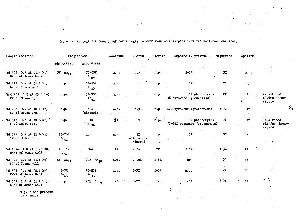
Td 456, 0.9 mi (1.4 km) N-NE of Jones Well
Td 415, 0.6 m i (1.0 km) SW of Jones Well
Tmd 283. 0.3 rr;i (0.5 km) hW of McGee Spr.
TaSle 1. Approximate phenocryst percentages i n i n t r u s i v e r o c k s a m p l e s from the Gallinas Peak area. .
Plagioclase Sanidine Quartz Bioti te AmphiboleIPyroxene , Elagnetite Apatite
phenocryst groundmass
5z &61 7 5 4 0 % n.p. n.p. n.p. 3 4 % 5% n.p.
An64
n.p. 65-75% n.p. tr n.p. 7% 2% n.p.
' A"39 n.p. 8 5 4 0 % n.p. tr: n.p. 7% phenocrysts 2% tr
A"42 3% pyroxene (groundmass)
Td 298, 0.4 m i (0 .6 km) n.p. ' 50% n.p. n.p. n.p. 40% pyroxene (groundmass) 5-7% ' tr SW of :.lcGee Spr. (a l te red)
Td 317, 0.2 m i ( 0 . 3 km) n.p. 1% $7 ' . 9% phenocrysts 7% tr 1z n.p. ! S of McGee Spr.
' lin56 7 5 4 0 % pyroxene (groundmass) .
Td 296, 0.6 m i (1.0 km) SW of XcGee Spr.
Td 465a, 1.0 m i (1.6 km) N-NE of Jones Well
Td 383, 1.0 m i (1 .6 km) SW of Jones Well
Td 542, 0.4 m i (0.6 km) W-NW of Jones Well
Td 549, 1.2 mi (1.9 km) N-NZ of Jones Well
15-202 n.p. n.p. 1% a s n.p.
An42 a l t e r a t i o n mineral
IO-15% 2ox 1% 1-2% tr A"59
5% An49 80% An3o n.p. 7-10% 3 4 %
5-7z 80-85% n.p. 3-5% 3-5% 4 4 8 An33
n.p. 80% An39 2% ' 1-2x tr
2% 3%
3-5% 1-3%
tr 3%
n.p. 2%
. 5% 5-7%
n.p. - nor present cr - trace
tr
1% '
tr
tr
tr
tr a l t e r e d o l v i n e pheno- crysts, .
\D a3
1% a l t e r e d o l i v i n e pheno- crysts

Because the youngest unit cut by the mafic and felsic dikes
is the tuff of Nipple Mountain, the dikes are inferred to be
of Spears age.
Mafic Dikes
Mafic dikes of variable mineralogy (table 1 ) are
found along the eastern boundary of the Gallinas Peak area.
In general, the youngest stratigraphic unit intruded by
these dikes is the lower member of the Spears Formation,
although two short mafic dikes intrude the tuff of Nipple
Mountain in the extreme southeastern portion of the study
area.
The mafic dikes of the Gallinas Peak area are, in
general, significantly altered to a mineral assemblage
consisting primarily of chlorite and calcite. These dikes
usually strike from about N 15"W to about N 5"E, but local
northwest strikes and easterly strikes are present. Dips on
the mafic dikes range from about 75Oto the west to about 60"
to the east. The dikes are usually discontinuous, sometimes
in an en echelon fashion (fig. 15); the longest, continuous
mafic dike crops out for about 800 ft (244 m). Mafic dikes
in the thesis area range in thickness from about 2 ft to
about 1 5 ft (0.6 to 5 m).
The mafic dikes vary in weathering habit; the
same dike may form a wall-like exposure for part of its
extent and be reduced to a small, rubbly mound at another

Figure 15. E n echelon mafic dike trend in southeast por- t i on of study area, about 0.3 m i ( 0 . 5 km) northwest of McGee Spr ing .

92
locality. Some mafic dikes have a platy fabric but most
have a blocky, massive appearance in outcrop.
In hand sample, colors of the mafic dikes range
from dark gray (N 4 ) to grayish olive (10 Y 4 /21 on fresh
surfaces and weather to various hues of brown. Texturally,
the dikes are porphyritic-aphanitic with altered plagioclase
being the dominant phenocryst and black, altered
ferromagnesian phenocrysts, as much as 4 mm in size,
subordinate in amount. The mafic dikes often contain from a
trace to about 2 percent, rounded quartz as much as 7 mm in
diameter.
Thin section analysis reveals that the mafic dikes
have a variety of compositions and textures (table 1 , and
Appendix). Two thin sections examined from the northeastern
Gallinas Peak area (Td 456 and Td 4 1 5 ) contain phenocrysts
of plagioclase and altered ferromagnesian minerals set in an
altered groundmass of chlorite and calcite. Trace amounts
of quartz xenocrysts with undulose extinction are also
present. Notably, these mafic dikes lack apatite in thin
section, while other intrusives in the Gallinas Peak area
consistently have a trace of apatite. Petrography of mafic
dikes from the northeastern Gallinas Peak area is further
described in the appendix.
Mafic dike samples from the southeastern Gallinas
Peak area (Td 298 and Tmd 283, table 1 and Appendix) show
similar alteration and textural variability as those mafic

93
dikes from the northeastern Gallinas Peak area. The
alteration of pyroxene and plagioclase in thin sections Td
298 and Tmd 283 is extensive, but their relative abundance
and arrangement is suggestive of a relict intergranular
texture. Typically, the rocks contain 10 percent or less
ferromagnesian minerals which are altered to calcite,
chlorite, and occasionally, quartz. A reaction rim of
calcite, pyroxene, and a brown mineral is found on the
traces of quartz xenocrysts that are present.
Approximately 950 ft (290 m) south of McGee Spring
is a short mafic(?) dike (sample Td 317). This dike
contains large prismatic sanidine xenocrysts(?) and rounded
quartz xenocrysts in a subophitic array of labradorite and
clinopyroxene. Other than the presence of the sanidine
xenocrysts(?), this dike is similar to the mafic dikes
previously described.
Sample Td 296 is altered in a different fashion
from the mafic dikes described above. Megascopically, it is
grayish yellow ( 5 Y 8/4) and dotted with hematite
pseudomorphs after pyrite. The dike could only be traced a
few meters, but several dikes, altered in a similar manner,
crop out sporadically in the southeastern Gallinas Peak
area, and are indicated as Td? on plate 1 (in pocket). Thin
section study (Td 296, table 1 and Appendix) shows that the
plagioclase phenocrysts are surprisingly fresh, although the
groundmass has been replaced by small, low-birefringent
crystals.

94
Quartz Latite Dikes and Plugs
Quartz latite intrusive rocks, present in the
east-central and northeast corner of the map area, consist
of three small plugs and several texturally distinct
porphyritic dikes. Quartz latite dikes are present in the
northeastern Gallinas Peak area, and a biotite-bearing dike
occurs in the east-central Gallinas Peak area.
Two quartz latite dikes, bearing phenocrysts of
feldspar, an altered ferromagnesian mineral, and quartz,
have been mapped in the northeastern corner of the Gallinas
Peak area. The dikes intrude the Baca Formation, and where
the terminus o f one dike was observed, the dike abruptly
ends in undisplaced bedding (fig. 16a). The dikes have a
general northwest strike which locally deviates to a
northerly or easterly strike. The dip of these dikes is
usually close to vertical. The longest of these quar
latite dikes crops out continuously for about 880 ft
m). The maximum thickness of these dikes is about 65
m). The dike rocks are well indurated and weather to
t5
(268
ft (20
resistant ridges 5 to 10 feet high ( 1 . 5 m to 3.0 m) as shown
in figure 16b.
Megascopically, the quartz latite dikes of the
northeastern Gallinas Peak area vary widely in phenocryst
content and in color within the same outcrop. In fresh hand
samples, the color ranges from medium dark gray (N 4), to
light olive gray (5 Y 5 / 2 ) . Weathered surfaces are mottled

a
Figure 1 6 . a . Abrupt terninat ion of quar tz l a t i t e Aike in 'undisplaced bedding of t he Baca Formation.
b . I r r egu la r ou tc rop pa t t e rn o f same d ike as i n a ; two h i l l s i n background are s i t e of small, qua r t z l a t i t e p lugs i n t ruded i n to bleached sandstones of t h e Baca Formation. Photographs taken 'zbout 1.1 m i ( 1 .8 . km) nor th of Jones Well.

96
with shades of yellow and brown. Phenocryst content ranges
from about 10 to 25 percent of the rock. Clear to chalky
phenocrysts o f plagioclase and sanidine average about 1 mm
in length, but are as much as 7 mm long in some samples. Altered ferromagnesian minerals are also present.
Phenocrysts of subhedral to rounded quartz, as much as 6 mm
in diameter, account for about 1 to 2 percent of any given
hand sample. A single thin section of these quartz latite
dikes (Td 465a) is described in the appendix.
A north to northwest-trending quartz latite dike
is present in portions of the east-central Gallinas Peak
area. This dike is intruded into the lower Spears, and
occupies a fault contact between the lower Spears, and the
tuff of Nipple Mountain in the area 0.4 mi (0.6 km)
northwest of Jones Well. The dike crops out in a
discontinuous pattern for about 1 . 3 mi (2.1 km) and ranges
in thickness from about 3 ft to about 1 6 ft ( 1 to 5 m); the
maximum thickness is attained south of Jaralosa Creek. The
dike usually weathers to a rubbly mound above the country
rock.
Fresh hand samples of this quartz latite dike are
dusky yellow to light olive gray (5 Y 6/4 to 5 Y 5/2) and
weather to shades of yellow and brown. The texture of the
dike is porphyritic-aphanitic with about 5 percent chalky,
prismatic plagioclase phenocrysts averaging about 1 mm in
length. Black biotite flakes, less than 1 mm long, make up

97
between 3 and 5 percent of any given hand sample.
Petrographic descriptions of this quartz latite dike
(samples Td 3 8 3 and Td 542) are located in the appendix.
A similar quartz latite dike has been mapped by
Chamberlin (1974, p. 52) in the area south of this study.
Chamberlin's map shows a quartz latite dike .along the same
trend as the quartz latite dike in the east-central Gallinas
Peak area. Chamberlin (p. 5 3 ) hypothesized that the quartz
latite dike in the Council Rock area was related to the
Gallinas Springs intrusive center, a Late Oligocene
andesitic vent located about 2.7 mi ( 4 . 3 km) southwest of
McGee Spring.
Three small, quartz latite plugs have been mapped
in the northeast corner of the Gallinas Peak area (fig.
16b). These plugs intrude the Baca Formation with no
visible disruption of bedding. The intrusives, all less
than 180 ft (55m) in diameter, weather to rounded knobs
rising about 20 ft ( 6 m) above the Baca Formation (fig.
16b).
In hand sample, chalky feldspars, averaging less
than 0.5 mm are set in a greenish-gray (5 GY 6 / 1 )
groundmass. Altered ferromagnesian minerals and rounded
quartz phenocrysts, as much as 1 ern in diameter, dot the
matrix. A single thin section studied ( T d 549) reveals that
the plagioclase and the ferromagnesian minerals are at least
partially replaced by chlorite, calcite, and clay. Quartz

phenocrysts present are rimmed by calcite. Detailed
petrographic description of Td 549 is found in the appendix.
Summary of Evidence of Inferred Intrusive
The occurrence of two major dike swarms, hematite
staining, weak propylitic alteration of rock units, and the
presence of an aeromagnetic high in the southeastern portion
of the study area (fig. IT), all suggest a concealed stock beneath the eastern margin of the Gallinas Peak area.
Epithermal quartz-carbonate veins, described in the economic
geology section, further support this conclusion. The two
dike swarms may provide the best field evidence of a
concealed intrusive. In a similar tectonic setting as the
Gallinas Peak area, Chamberlin (1974) and Wilkinson (1976)
mapped latite dikes along radial and concentric faults
associated with the Tres Montosas stock. The fact that
felsic as well as mafic dikes occur in the two dike swarms
also suggests a concealed intrusion. The correlation
between mafic.and felsic dikes with known intrusives has
been demonstrated in the Magdalena area by Brown (1972), who
found latitic and andesitic dikes associated with the
Magdalena composite pluton.
Indirect evidence of doming over the postulated
intrusive exists in the northeastern Gallinas Peak area.
Here, abrupt thining of the lower Spears and younger
Oligocene volcanic rocks, and the presence of numerous local

Figure 17. Residual magnetic intensity map showing magnetic high i n e a s t e r n . p a r t o f Gallinas.:.Peak area (hachured.) . , Contour.' '5n:kerial 3 ? $ 0 gammas. (From U.S. Geological Survey Open-File Maps 247 and 271, southwest New'Mexico, 1 9 7 3 . )
99

100
unconformities suggest the presence of significant
paleo-topographic relief. Because of these thickness
changes, a Spears age for the doming and thus intrusion, is
inferred. This age is consistent with the fact that the
youngest unit cut by dikes in the study area is the tuff of
Nipple Mountain. Alternatively, the stratigraphic
discontinuities listed above may be attributed to movement
along a transverse structural zone of the Tijeras lineament
as described in a following section on structure.
Chamberlin (1974) and Wilkinson (1976) have
postulated several concealed stocks, distributed along a
northerly trend, adjacent to the Nulligan Gulch graben (see
Chamberlin's fig. 16). In addition, Chamberlin suggested
that the Gallinas Springs fault, a major fault which splits
into two faults that continue into this study area, was of
major importance in controlling the distribution of the
postulated stocks. Chamberlin's hypothesis is supported by
studies in the Magdalena area where Chapin and others
(1974a) have suggested that early rift faults broke the
roofs of Oligocene batholiths, promoting the emplacement of
epizonal plutons in the Kelly mining district. The presence
of the exposed and postulated intrusives along the Gallinas
Springs fault suggests a possible similar situation to that
in the Kelly district. In this study area, the presence of
an aeromagnetic high, located along strike of one of the
faults related to the Gallinas Springs fault, adds support
to Chamberlin's fault control hypothesis.

101
MIOCENE DEPOSITS
Popotosa Formation
The Popotosa Formation was named by Denny ( 1 9 4 0 )
who described areas of good exposure in Arroyo Popotosa on
the east side of the Sierra Ladron. A detailed study of the
Popotosa Formation is presented in a doctoral dissertation
by Bruning ( 1 9 7 3 ) , who concluded that the Popotosa is the
basal Santa Fe Group in the Socorro region. The Popotosa
was deposited in a 40 mi- ( 6 4 km-) wide, rift-related
trough, referred to as the Popotosa basin. Accumulation of
detritus in the Popotosa basin began about 24 m.y. ago and
continued t o at least late-Miocene time (Bruning, 1 9 7 3 ) .
The Gallinas Mountains and the Colorado Plateau, marking the
west and northwest margin of the Popotosa basin, shed
detritus into the basin throughout its history (Bruning,
1 9 7 3 ) . Other margins of the basin are less well documented.
The Popotosa basin has now been broken into three parallel,
1 1 to 1 4 mi- (18 to 23 km-) wide basins which are separated
by horsts associated with the Rio Grande rift (Bruning,
1973; Chapin and Seager, 1 9 7 5 ) .
F o u r minor exposures of the Popotosa Formation are
present in the Gallinas Peak Area. Three of these exposures
are found on the north side of McGee Canyon, east of McGee
Spring; the fourth is in Jaralosa Canyon, north of Jones
Well. A l l of these exposures are adjacent to the Mulligan

102
Gulch graben. In McGee Canyon, one outcrop of the Popotosa
Formation lies adjacent to the Hells Mesa Tuff; in Jaralosa
Canyon, the Popotosa Formation lies on the Baca Formation.
Deposition of the Popotosa Formation on such units of
diverse age suggests that, in the Gallinas Peak area, at
least some rift-related faulting took place prior to
Popotosa time.
The Popotosa Formation in the Gallinas Peak area
has a sub-horizontal attitude and consists of conglomeratic
mudstones and muddy sandstones. The unit contains a
moderately to poorly sorted array of subangular lithic
fragments. The clasts, predominantly andesite, A-L Peak
Tuff(?), and Hells Mesa Tuff, range from about 3 mm to about
1 5 cm in longest dimension. The clasts are ususally set in
a light-brown, calcite-cemented matrix o f silt and clay.

PLIO-PLEISTOCENE DEPOSITS
Piedmont Gravels
Piedmont gravels cover a large portion of the east
margin of the study area, where they form a surface which
dips gently eastward into the Mulligan Gulch graben. This
piedmont surface is dissected by tributaries of Jaralosa
Creek on the west and north, and by Deep Well and McGee
Canyons on the south. In the thesis area, the piedmont
gravels are probably about 200 ft ( 6 1 m) thick and are
generally above 7300 ft ( 2 2 2 5 m) in elevation.
All rock types found in the Gallinas Peak area,
primarily the Spears Formation, Hells Mesa Tuff, and A-L
Peak Tuff, occur in the piedmont gravels. These clasts are
angular to rounded blocks as much as 30 cm in largest
diameter.
Mayerson ( 1 9 7 9 ) mapped extensive piedmont gravels
to the northeast of the Gallinas Mountains and hypothesized
that these gravels were formed by coalescing alluvial fans
derived from the Gallinas Mountains. This is probably also
the case for the piedmont gravels of the Gallinas Peak area,
which are continuous with the piedmont gravels of Mayerson"~
area; however, the gravels are now separated from the
present Gallinas Mountain front by a broad erosional valley.

104
QUATERNARY DEPOSITS
Talus, Colluvium, and Landslide Deposits
Colluvial deposits and talus were mapped in the
Gallinas Peak area only where such debris obscured contacts.
The author found, as did Chamberlin (1974), that the basal
contacts of the cliff-forming Hells Mesa Tuff and tuff of
Nipple Mountain were the primary sites of such deposits.
Landslide and slump blocks of the Hells Mesa Tuff
are present at the head of Three Log Spring Canyon and on
the east side of Gallinas Peak. Nearly vertical slopes, and
the rubbly upper surfaces of the upper Spears andesites
probably contributed to the instability o f the overlying
Hells Mesa Tuff in areas of slumping.
Alluvium
Recent stream gravels and sand deposited in the
larger drainages are grouped as alluvium in this study.
Mappable deposits of alluvium in the Gallinas Peak area are
present in the head of Three Log Spring Canyon and in the
tributaries and main channels of McGee, Deep Well and
Jaralosa Canyons. Present stream deposits are a mixture of
locally-derived boulders, cobbles, pebbles, and sand.
Older alluvium may be present in the flat, gently
sloping meadows adjacent to the main channel of Jaralosa

105
Creek. These meadows, mantled by soil and eolian sand, are
about 5 to 1 0 ft (1 .5 to 3 m) above the present stream
channel, and could represent older, elevated alluvial
deposits of Jaralosa Creek.
Eolian Sand
Light-brown, wind-blown sand mantles many
topographic lows and thinly veneers a few higher elevations
in the Gallinas Peak area. The sands are most extensive,
and probably thickest, at the west margin of the thesis
area, adjacent to the Plains of San Augustin. Barchan
dunes, clearly discernable on aerial photographs, but
ambiguous at ground level, indicate prevailing winds from
the southwest. Assuming a similar wind direction throughout
Holocene time, the source of the eolian sands was probably
the Plains of San Augustin. A pluvial lake occupied the
Plains of San Augustin during Wisconsin time and desiccation
and deflation o f the lake basin provided enormous quantities
of sand in post-Wisconsin time (Chapin and others, 1978~).
At lower elevations, thick stands of Ponderosa
pines generally grow only on the eolian sand, in arroyos, o r
on shaded canyon slopes. In the eolian deposits, the
present water table is probably perched within the sands
overlying the less permable volcanic units, thus allowing
for lusher tree growth.

STRUCTURE
Regional Structure
A three-stage tectonic model for the evolution of
the Cordilleran foreland in the Arizona-New Mexico-Colorado
region during the Cenozoic has been outlined by Chapin
(197413). Initially, during the Laramide orogeny, an
east-northeast directed compressional stress field uplifted
and formed the southern Rocky Mountains. As the Laramide
orogeny closed, it was followed by a neutral stress field of
significant duration; this stress field was in turn
followed by an east-west oriented tensional stress field
which induced rifting and basin and range faulting (Chapin,
1974b; Chapin and Seager, 1975).
Structural flaws in the continental lithosphere
were instrumental in dictating structural trends associated
with the Rio Grande rift (Chapin and others, 197413; Chapin
and others, 1978a,b; Chapin, 1978). Such a structural flaw
is the northeast-trending Morenci lineament, along which the
San Augustin rift opened as a bifurcation of the Rio Grande
rift (Chapin, 1971b; Chapin and others, 1978a,b). A
transverse shear zone of the Morenci lineament is
characterized in the Socorro-Magdalena area by opposing
structural symmetries across the lineament (Chapin and
others, 1978a,b,c). Shear zones such as this influenced
tectonic style, the distribution of volcanic centers, and

the distribution of present-day magma bodies (Chapin and
others, 1978a,b,c).
A second lineament, the Tijeras lineament, has
been documented northeast of the study area and may have had
some influence on the structure of the Gallinas Peak area.
Although less well documented than the Morenci lineament,
the northeast-trending Tijeras lineament possibly represents
a basement fault of Precambrian ancestry. In a study of the
economic mineral potential of the Riley-Puertecito area,
Chapin and others (1979) have reported that late-Cretaceous
sedimentation was strongly influenced by differential
vertical movements across the Tijeras lineament. Work
northeast of this study by Mayerson (1979) attributed
thickness variations and local unconformities in the
Oligocene volcanic section to transverse structural zones
associated with the Tijeras lineament.
The Mulligan Gulch graben is a north-trending,
early rift structure which separates the Gallinas Range from
the Bear Mountains to the east of the study area. The depth
of the graben shallows southward across the 'Morenci
lineament, south of this study area (Chapin and others,
1978a,b).
Local Structure
A fault map of the Gallinas Peak area, showing
distribution of faults in the study area, is shown in plate

108
2 (in pocket). This map shows that north-trending rift
faults dominate the structural pattern of the Gallinas Peak
area and that transverse normal faults are less common in
the study area. No structural evidence of compressional
(Laramide) deformation was encountered in the Gallinas Peak
area; however, folding attributable to the effects of fault
drag or vertical tectonics was recognized.
North-Trending Faults
The structural pattern of the Gallinas Peak area
is dominated by north-trending extensional faults. The
frequency of these faults increases from west to east in the
study area, reflecting the tectonic importance of the Rio
Grande rift. The extensional faults have a distinct
northerly trend, but vary locally from about N 20"W to about
N 10'E. Such variances in trend are common in rift-related
structures (Freund, 1978).
The youngest units displaced by north-trending
faults are basaltic-andesite flows which overlie the tuff of
South Canyon in the northeast portion o f the study area.
Some north-trending faults in the area probably developed
during depostion o f the lower member of the Spears
Formation. In the northeast portion of the Gallinas Peak
area the lower Spears thins abruptly, in an eastward
direction, across two, down-to-the-west faults.
Additionally, mafic dikes, thought to be of middle Spears

age, are emplaced along these two faults. Some
north-trending faults have been intruded by mafic and felsic
dikes; however, not all dikes were emplaced along a
recognizable stratigraphic displacement.
The maximum stratigraphic throw on a
north-trending fault occurs in the southeast portion of the
area. Here, about 1475 ft (449 m) of down-to-the-west
displacement results in a structurally high block of lower
Spears Formation juxtaposed against Hells Mesa Tuff.
East-west cross sections (plate 1 ) show that the
major north-trending faults in the Gallinas Peak area
generally alternate from down to the east to down to the
west. This has formed a series of broad, alternating horsts
and grabens, east to west, across the thesis area.
A definite genetic relationship exists between the
north-trending faults and extension of the Rio Grande rift
(and the Mulligan Gulch graben). However, another possible
mechanism for some minor north-trending faults is tensional
breakup over the arched portion of the eastern Gallinas Peak
area. Mechanisms which could explain the arching of the
eastern portion of the study area are discussed in a
following section on folding.
Transverse Faults
Transverse normal faults are less well developed
than the north-trending normal faults in the Gallinas Peak

110
area. About a dozen transverse faults have been mapped in
the study area; of these only two were traceable for more
than 2000 ft ( 6 1 0 m). Of the two longer faults, one trends
west-northwest across the north-central portion of the study
area, and the other transects the south-central portion of
the area along a northeast trend. Each of the two longest
transverse faults apparently dies out toward the center of
the map area; here, displacement is probably taken up by the
north-trending faults of the central Gallinas Peak area.
This suggests that these transverse faults may be
contemporaneous with the north-trending normal faults.
Additionally, several other transverse faults take on a
northerly trend over part of their length, further
suggesting contemporaneity and a genetic tie with the Rio
Grande rift system.
Some possible mechanisms of formation of the
transverse faults are:
1 ) These faults are related to a broad uplift of
the Gallinas Peak area, forming a conjugate fault pattern
with the north-trending faults across the crest of a broad,
northerly elongate dome.
2 ) The two extensive, down-to-the-north faults may
reflect en echelon movement along the northeast-trending
Tijeras lineament. Evidence of structural discontinuities
related to the Tijeras lineament has been described by
Mayerson (1979) for the region just northeast of the

Gallinas Peak area.
the Mulligan Gulch
1
Mayerson
graben in
1
suggested
right-la
that deflection
teral sense coul
of
d be
attributed to basement fault zones of the Tijeras lineament.
A crude northeast-trending cutoff of the piedmont gravels in
the northeast Gallinas Peak area, abrupt thinning of
Oligocene volcanic rocks to the northeast, and the presence
of abundant, local unconformities in the northeast corner of
the study area all support structural discontinuities
related to the Tijeras lineament.
3 ) The transverse faulting may be a reflection of
movement of the Colorado Plateau to the northwest, away from
its southeast corner; this has been proposed by Chapin
(1971b) as a possible mechanism for the formation of the San
Augustin rift, south of the study area. The formation of a
minor sag between the Gallinas Range and the Colorado
Plateau may have thus resulted in the transverse fault
pattern.
4) The transverse faults could merely reflect
local stress perturbations in a regional, east-west
extensional stress field. These faults could thus repr es ent
an inherent feature of rift faulting in the Gallinas Peak
area.
Folding
The general westward tilt of the Gallinas Peak
area, away from the Mulligan Gulch graben, is a common

112
feature of fault blocks bordering the Rio Grande rift
(Chapin, 1971b). This westward tilt is reversed on the east
margin of the study area where pervasive eastward dip into
the Mulligan Gulch graben is found. This monoclinal flexure
extends from the Abbe Spring area on the north (Mayerson,
1979) to Cat Mountain on the south (Wilkinson, 1976).
Separate mechanisms for the formation of the
graben-bounding monocline have been examined by Chamberlin
(1974) and by Mayerson (1979). Chamberlin proposed that
intrusion of a northerly elongate pluton and concomitant
upthrusting, reactivating basement faults adjacent to the
Mulligan Gulch graben, resulted in a monoclinal flexure.
The obvious linearity of inferred stocks in the Gallinas
Peak area and Council Rock area along with the Tres Montosas
stock, support a larger, parent intrusive at depth,
adjacent to the Mulligan Gulch graben (see Chamberlin, 1974,
fig. 1 6 ) . Chamberlin argued that strata would be more apt
to break than to fold under a tensile stress and concluded
that active upthrusting would be a more realistic mechanism
to produce a monocline. Mayerson (1979) discounted
Chamberlin's magmatic intrusion hypothesis and concluded
that, based on the close spatial association of the
monoclinal hinge with the fault system of the Mulligan Gulch
graben, fault drag was the cause of the flexure. Because o f
the arching of strata (see cross-sections, Plate 1 ) over an
inferred intrusive in the Gallinas peak area, an

1 1 3
intrusive-related upthrusting may also have formed the
monoclinal flexure (or at least enhanced the effects of drag
in this area of the graben).
An alternative to Mayerson's and Chamberlin's
hypotheses for the formation of the monocline is possible
diapiric intrusion o f Mesozoic shale sequences and Paleozoic
evaporite horizons into the structurally weak zones adjacent
to the Mulligan Gulch graben. Diapiric intrusion of shale
has been hypothesized in the Espaiiola basin by Lisenbee
(1976) to explain small, elongate, dome-like structures
adjacent to a regional fault system. These structures are
underlain by anomalous thicknesses of Cretaceous shale.
Lisenbee suggested that natural gas mixed with the shales
and contributed to their bouyant rise. A similar situation
may exist in the Gallinas Peak area; here isostatic rise of
Permian evaporite sequences along the border fault system o f
the Mulligan Gulch graben could have produced a vertical
stress resulting in a monoclinal warp above the diapiric
structure. This situation would not preclude a pluton at
depth, and it is possible that such an intrusion could have
provided a thermal source necessary to increase the
plasticity of Paleozoic and Mesozoic evaporite and shale
sequences.
Cross-sections in the northeastern portion of the
thesis area show anticlinal folding of the Spears and Baca
Formations where these strata dip toward adjacent,

1 1 4
north-trending faults (see cross-section A - A ' , Plate 1 ) .
Because these flexures lack adjacent synclines, a mechanism
other than active compression may have caused the folding in
the northeast portion of the study area. Mayerson (1979)
has suggested reverse drag as a possible mechanism of
folding in the post-Laramide formations of the Corkscrew
Canyon--Abbe Spring area, northeast of this study. By
assuming that fault planes dip less steeply at depth and
that displacement is relatively large (greater than 100 ft;
30 m), large gaps between the downthrown blocks and upthrown
block will form. Hamblin ( 1 9 6 5 ) , in his study of reverse
drag in normal faults on the Colorado Plateau, has shown
that the downthrown blocks of normal faults can compensate
for spatial gaps by tilting of strata of the downthrown
block, toward the fault plane, resulting in reverse drag.
It is concluded that, in the Gallinas Peak area, reverse
drag is responsible for the anticlinal folds in the Spears
and Baca Formations.

115
ECONOMIC GEOLOGY
The Gallinas Peak area is located about 17 mi (27
km) northwest of the Kelly mining district, one of the
largest zinc-lead-copper districts in New Mexico. In that
district, rich zinc-lead-copper orebodies were formed in
Paleozoic limestones adjacent to stocks intruded along the
structural margin of the Magdalena cauldron (Blakestad,
1978; Chapin and others, 1978~).
Two much smaller mining districts, the Council
Rock district and the Cat Mountain district, are located
from 4 to 1 1 mi ( 6 to 18 km) south of the Gallinas Peak
area. Lasky (1932) has reported that lead-carbonate veins
of the Council Rock district were worked in the 1880's for
their silver content. Some of the ore from that district
reportedly averaged as much as 250 dollars per ton
(Chamberlin, 1974). The Cat Mountain district was worked,
around the turn of the century, for gold at the intersection
of quartz veins (Wilkinson, 1976). The sixty prospect,
adjacent to the Cat Mountain district, produced about 356
tons of disseminated silver, copper, and lead ore
(Wilkinson, 1976).
In the Gallinas Peak area, prospecting has
generally been confined to the eastern two thirds of the
area and consists of small pits and shallow shafts along
faults or adjacent to dikes. No production of ore from
these workings is known from the thesis area.

Alteration
Alteration in the Gallinas Peak area is most
intense along the area's eastern margin (plate 2). Three
types of alteration, affecting the Spears Formation, Hells
Mesa Tuff, and dikes, are recognized. These are weak
propylitization, hematite staining, and minor
silicification. Epithermal veins of quartz, calcite, and
minor veinlets of pyrite are also present.
Propylitization
The effects of propylitization are best developed
in the lower Spears Formation and portions of the Hells Mesa
Tuff in the southeastern Gallinas Peak area. Thin sections
show that mafic minerals and groundmass constituents of
these units, when altered, have been partially to completely
replaced by chlorite, calcite, and sparse epidote.
Additionally, clay minerals are often seen as an alteration
product of groundmass minerals. Veinlets of quartz and
calcite are sometimes found in thin sections of
propylitically altered units. Weak propylitization is also
evident in some mafic and quartz latite dikes of the eastern
portion of the thesis area. Chlorite replacement of
phenocrysts and groundmass constituents often imparts an
olive-green color to the altered dikes. Thin sections
reveal that the chlorite is often accompanied by calcite and

clay minerals, but epidote is notably absent in the altered
dikes. For a more complete description of these alteration
textures the reader is refered to petrographic descriptions
of the Spears Formation, Hells Mesa Tuff, and dikes.
Hematite Staining
Hematite staining, sometimes accompanied by
silicification, most commonly affects the tuff of Nipple
Mountain in the eastern portion of the Gallinas Peak area.
One area of particularly intense hematite staining of this
tuff is found adjacent to Jaralosa Creek, about 0.6 mi (1 .0
km) east of Sawmill Well. Here the tuff of Nipple Mountain
is stained bright orange where it crops out adjacent to the
intersection of two faults. The orange color is probably
caused by surface oxidation of pyrite; just north of this
outcrop euhedral holes, from which hematitically altered
pyrite cubes have been leached, were seen in rubbly float
from the tuff of Nipple Mountain.
Hematite staining is sometimes found in the lower
member of the Spears Formation and in the Hell Mesa Tuff in
the east central and southeastern portions of the thesis
area. In these units the staining, accompanied by
hydrothermal bleaching, imparts varied hues of yellow and
orange to altered outcrops. This type of alteration in the
lower Spears is often confined to within a few feet of
sheared outcrops, or along dike margins. Here, the hematite

118
staining is probably associated with both the migration of
hydrothermal fluids along faults and the emplacement of
dikes.
Silicification and Veining
Two areas of extensive silicification of the tuff
of Nipple Mountain are found in the study area. One such
area is on a ridge that is bounded by a north-trending fault
just east of Jones Tanks. Presumably, the fault acted as a
conduit for silica-bearing fluids. A second area o f
silicification, present as quartz and opaline silica
veining, occurs in the tuff of Nipple Mountain in the
southeast to east-central portion of the study area. In
this area, the silicified tuff is closely jointed and
sheared adjacent to faults, and some joint surfaces are
coated with iron oxide; locally the tuff appears
hydrothermally bleached.
Quartz-calcite veins, as much as 5 ft ( 1 . 5 m)
wide, are present along faults in the north-central and
eastern Gallinas Peak area (plate 2 ) . In some places, the
veining is along shear zones of unknown displacement and
cannot be traced more than a few feet along strike. In
these veins, euhedral rhombs of calcite, as large as 3 in.
(7.6 cm) on a side, are often dark gray to black, and are
sometimes associated with chalcedony or fine-grained quartz.
Wilkinson ( 1 9 7 6 ) concluded that black coloration in calcite

veins of the Tres Montosas area was caused by inclusions of
manganese and iron oxides; he speculated that the inclusions
of manganese oxides may carry minor silver values in the Cat
Mountain district. Some of the quartz-calcite veins in the
Gallinas Peak area have been prospected on a small scale.
It is not known whether these veins were prospected for
manganese or for their possible silver content.
Pyrite cubes, as much as 2 mm on a side, were
found coating surfaces of intensely hydrothermally altered
rocks of the lower Spears Formation in a waste dump south of
McGee Spring. A vertical shaft, located next to the waste
dump, may have been as much as 30 ft (9 .1 m) deep, judging
from the size of the dump. Some rocks in the waste dump are
intensely brecciated, cemented with silica, bleached, and
variously stained with red, orange, and black iron oxides.
Quartz crystals, as much as 0.5 in. ( 1 . 3 cm) in length fill
larger open spaces in some rocks of the waste dump. This
area of alteration in the lower Spears is probably related
to intrusion of an adjacent, mafic(?) dike (hematite
staining and bleaching are often found on dike margins in
the study area). This site was the only occurrence of fresh
pyrite found in the thesis area. However, euhedral holes,
formed by leaching of hematitically altered pyrite in
altered tuff of Nipple Mountain, were found in the extreme
north-central portion of the thesis area.
1 20
Base and Precious Metals
The presence of an inferred intrusion in the
eastern Gallinas Peak area presents the possibility of
epithermal replacement bodies in favorable horizons at
depth. Chapin and others ( 1 9 7 4 a ) have found that
mineralization in the Magdalena area is associated with
epizonal stocks where the Kelly Limestone (Mississippian)
has produced large quantities of zinc, lead, and silver ore
in the Kelly mining district. The depth to the Kelly
Limestone in the Gallinas Peak area is estimated to be
between 7,170 ft (2185 m) and 8,295 ft (2528 m) assuming the
following thicknesses:
0-1125 ft (343 m) Spears Formation
515 ft ( 1 5 7 m) Baca Formation
2920 ft ( 8 9 0 m) Mesozoic rocks (from Mayerson, 1979)
2535 ft (773 m ) Permian rocks (from Tonking, 1957)
1200 ft (366 m) Pennsylvanian rocks (from Siemers, 1973)
Similarly, the depth to possible replacement deposits in
Permian limestones would be between 4560 ft (1390 m) and
3435 ft (1047 m).
Chamberlin ( 1 9 7 4 ) has estimated the depth to an
inferred pluton in the Council Rock district to be within
2000 ft ( 6 1 0 m) of the surface based on surficial exposure
of the Tres Montosas stock and doming over the inferred
intrusive. However, estimating depth to the postulated
pluton in the Gallinas Peak area is difficult. Intense

121
hematite staining, numerous exposed dikes, and epithermal
quarte-carbonate veins probably indicate that the intrusive
is at a moderately shallow depth. In fact, doming could
have brought the intrusive to within 2000 ft ( 6 1 0 m) of the
surface. Because dikes are most abundant in the northeast
and southeast portions of the area, the intrusive could be
closest to the surface in these areas.
The lower Spears Formation in the eastern portion
of the Gallinas Peak area may be a viable exploration
target. The intense hydrothermal alteration of the Spears
Formation suggests that this andesitic to latitic unit may
have been sufficiently reactive to form base metal o r
precious metal deposits at shallow and, perhaps economically
minable depths. Southwest of this study, near Magdalena,
Simon (1973) has found silver mineralization associated with
reactive, vesicular, mafic lavas of the Silver Peak area
(the La Jara Peak basaltic andesite).
c 4
Uranium
The Baca Formation, which crops out only in the
northeast corner of the thesis area, has historically been
the primary target for uranium exploration in the region
around the Gallinas Peak area (Chapin and others, 1979).
The Baca Formation has been divided into three members by
Potter (1970), Massingill (1979), and Cather (1980). In the
Riley-Puertecito area, it is the middle member which is most

122
favorable to uranium mineralization because of its
thickness, lateral extent, permeability, bleached nature,
and abundant carbonaceous fragments (Chapin and others,
1979). In the Gallinas Peak area, the Baca Formation is
also bleached a light-gray to light-yellow color and
contains local carbonaceous trash. The bleached nature of
the Baca Formation, along with some anomalous radioactivity
present in outcrops along Jaralosa Creek, indicates that the
unit has probably been a conduit f o r mineralizing solutions
in the study area. Mineralization in the Baca Formation
occurs just north of this study where Anonymous (1959) has
noted uranium associated with carbonaceous materials of the
Baca Formation.
Because the Baca Formation dips southward and
westward under the volcanic units of the Gallinas Peak area
its uranium potential c o u l d be enhanced; Chapin and others
(1979, p. 27) suggest that the key to exploration of the
Baca Formation is to find areas where the middle member has
been downfaulted and protected from leaching. Tertiary
volcanic cover in the thesis area could have also protected
the Baca Formation from leaching and the unit is possibly
mineralized where it is concealed.
Documented occurrences of uranium mineralization
n e a r the study area include the Hook prospect, about 3 mi (5
km) northeast of the Gallinas Peak area (Anonymous, 1959;
Mayerson, 1979),and disseminated uranium in Baca channel

sandstones along Jaralosa Creek (Anonymous, 1959) . However,
no prospects were seen in the Baca Formation in the Gallinas
Peak area.
Coal
A modest amount of coal has been mined from the
upper portion of the Crevasse Canyon at the Hot Spot mine,
about 4 mi (6 km) northeast of the Gallinas Peak area
(Mayerson, 1979) . Although no mining of coal has been done
in the Gallinas Peak area, minor coal beds, a few feet
thick, crop out in the extreme northeast portion of the
area. Exposures of the Crevasse Canyon are limited in the
study area, making the resource potential difficult to
determine. Should the Crevasse Canyon found in the
northeastern Gallinas Peak area continue west and south
beneath Tertiary cover, a significant amount of coal may be
present in the thesis area. However, large depths to coal
horizons would make strip mining uneconomic. Studies
concerning the Crevasse Canyon near the Gallinas Peak area
by Chapin and others ( 1 9 7 9 ) and Mayerson ( 1 9 7 9 ) have
indicated that the coal beds of the upper portion of the
Crevasse Canyon grade rapidly into organic shales both
laterally and vertically. This discontinuity of the upper
coal beds demeans their resource potential except where the
beds are readily strippable. The coal beds o f the lower
Crevasse canyon are more laterally continuous (Chapin and

124
others, 1 9 7 9 ) , but aepths to these coal horizons in the
Gallinas Peak area are probably prohibitive for mining.

125
CONCLUSIONS
The following conclusions regarding the
stratigraphy, structure, and economic potential of the
Gallinas Peak area can be made from this study.
Stratigraphy
Oligocene volcanic rocks and less voluminous,
interbedded sedimentary rocks cover most of the Gallinas
Peak area. A minor amount of prevolcanic Eocene and
Cretaceous sedimentary rocks are exposed in the extreme
northeast portion of the study area, where they dip gently
south and west beneath the volcanic units.
The tuff of Granite Mountain, a quartz-latite
ash-flow tuff which is characteristically near the top of
the Spears Formation elsewhere in the Socorro-Magdalena area
is not present in the Gallinas Peak area. Replacing the
tuff of Granite Mountain in most of the Gallinas Peak area
is a thick (greater than 300-ft, 91-m) sequence of basaltic
andesites which may reflect a buried shield volcano near the
west margin of the study area. These flows pinch out toward
the northwest and northeast margins of the study area.
Because of this abrupt thickness change and probable uplift
and erosion during Spears time, the Hells Mesa Tuff
unconformably overlies the tuff of Nipple Wountain in the
northwest and northeast portions of the study area.

1 2 6
The tuff of Lemitar Mountains, a regionally
extensive ash-flow tuff that is normally between the A-L
Peak Tuff and the tuff of South Canyon, is not present in
the Gallinas Peak area. In place of the tuff o f Lemitar
Mountains in the study area is a thin sequence o f basalts
and sedimentary rocks. The tuff of South Canyon in the
southwestern Gallinas Peak area is anomalously thick and may
reflect development o f considerable topography in this area
prior to emplacement o f the tuff.
A concealed, Spears-age intrusive is postulated t o
have been emplaced along north-trending faults bounding the
Mulligan Gulch graben in the Gallinas Peak area. Evidence
supporting a concealed intrusive is: 1 ) the presence o f an
aeromagnetic high in the southeast portion of the study
area; 2 ) the presence of mafic and felsic dikes in the
northeast and southeast portion of the study area; 3 )
locally intense hydrothermal alteration of the Spears
Formation, and weak propylitization of dikes; and 4) the
presence of epithermal quartz-calcite veins. It is possible
that doming of the eastern margin of the thesis area may
have brought the intrusive to within 2000 ft (610 m) of the
surface.
Structure
The Gallinas Peak area consists of several blocks
which gently dip southwest; this regional dip is away from

127
the Colorado Plateau and the Rio Grande Rift, to the north
and east of the study area, respectively. The structurally
highest portions of the area are on the east margin where
the units have been arched over an inferred intrusive. The
eastern boundary of the area marks the western border of the
Rio Grande Rift; along this boundary, strata dip steeply
eastward into the Mulligan Gulch Graben.
North-trending rift faults are the most common
structures in the Gallinas Peak area; here they form a
series of horsts and grabens across the range. These faults
increase in frequency and amount of displacement eastward,
toward the west edge of the Mulligan Gulch graben. Some
north-trending faults probably developed during lower Spears
time.
Transverse normal faults, probably contemporaneous
with north-trending faults, are minor in comparison with
north-trending faults. The transverse faults have several
possible origins: 1 ) they may represent a conjugate fault
pattern related to doming of the Gallinas Peak area over a
postulated intrusive; 2) they may be a reflection of a
basement fault zone related to the Tijeras lineament; 3 )
these faults could be related to differential movement of
the Colorado Plateau to the northwest, away from the
Gallinas Peak area; and 4) the transverse faults may merely
represent a deviant fault trend local to the Gallinas Peak
area and not directly attributable to regional structures.

1 2 8
Structural evidence of movement related to the
northeast-trending Tijeras lineament in the northeastern
Gallinas Peak area is the presence of structurally high
blocks exposing pre-volcanic units. These blocks may be
related to uplift associated with a basement fault zone.
Other evidence which supports structural discontinuities
related to the Tijeras lineament are the abrupt thinning of
volcanic units to the northeast, and the presence of
numerous, local unconformities in the northeast portion of
the Gallinas Peak area. Alternatively, these structural
features may be related to doming over an intrusive or an
evaporite diapir in the eastern Gallinas Peak area.
A monoclinal flexure, adjacent to the Mulligan
Gulch graben is present on the east margin of the study
area. This flexure extends from Abbe Spring on the north to
Cat Mountain on the south. The monocline may be attributed
to 1 ) upthrusting associated with the emplacement of a
northerly elongate intrusion adjacent to the Mulligan Gulch
graben; 2) fault drag related to the fault system bounding
the graben; or 3 ) possible diapiric intrusion of Mesozoic
shale sequences and/or Paleozoic evaporite horizons.
Alteration and Mineralization
Alteration is best developed in the eastern
portion of the Gallinas Peak area where it consists of weak
pr'opylitization of the Spears Formation, the Hells Mesa

129
Tuff, and mafic and felsic dikes. Silicification of the
tuff of Nipple Mountain is also common adjacent to faults.
Hydrothermal effects of bleaching and hematite staining in
the lower Spears Formation, the tuff of Nipple Mountain, and
the Hells Mesa 'Puff are also found in the eastern portion of
the study area. Here, hematite staining is often found in
sheared outcrops and adjacent to dikes. Manganiferous
calcite veins with microcrystalline quartz, emplaced along
faults in the central and eastern portions of the study
area, probably represent low-temperature epithermal veining
related to intrusive activity at depth. Fresh pyrite has
been found as a minor constitiuent of a hydrothermally
altered outcrop adjacent to a dike in the southeast portion
of the study area but may have been formerly present in all
hematite-stained areas.
An inferred, concealed intrusive in the eastern
portion of the study area may have resulted in replacement
orebodies in Paleozoic limestones similar to those orebodies
of the Magdalena district. However, depths to favorable
replacement horizons are probably uneconomic. An
alternative exploration target of low to moderate
favorability in the Gallinas Peak area is the Spears
Formation which is andesitic to latitic in composition and
may be sufficiently reactive to host shallow base or
precious metals deposits adjacent to the inferred intrusive.
Dike swarms in the northeast and southeast portions of the

130
t h e s i s a r e a s u g g e s t t h a t d e p t h t o t h e i n t r u s i v e would be
l e a s t i n t h e s e a r e a s .
The Baca Formation i s a h o s t f o r u r a n i u m
m i n e r a l i z a t i o n a l o n g J a r a l o s a C r e e k j u s t n o r t h e a s t o f t h e
s t u d y a r e a . The b l e a c h e d n a t u r e o f t h e Baca Format ion i n
t h e s t u d y a r e a , a l o n g w i t h m i n o r r a d i o a c t i v i t y a n o m a l i e s
p r e s e n t i n o u t c r o p s a l o n g J a r a l o s a C r e e k , i n d i c a t e t h a t t h e
B a c a a c t e d a s a passageway for m i n e r a l i z i n g s o l u t i o n s . T h e
Baca may h a v e i n c r e a s e d u r a n i u m p o t e n t i a l i n a r e a s w h e r e i t
d i p s g e n t l y b e n e a t h y o u n g e r v o l c a n i c s t r a t a a n d may have
b e e n p r o t e c t e d f r o m l e a c h i n g .

131
REFERENCES
Anonymous, 1959, Uranium deposits in the Datil Mountains-Bear Mountains region, New Mexico, in West-Central New Mexico: New Mexico Geologioai-Society, 10th Field Conference, Guidebook, p. 135-143.
Blakestad, R.B., 1978, Geology of the Kelly mining district,
University of Colorado, 127p. Socorro County, New Mexico [M.S. thesis]: Boulder,
Brown, D.M., 1972, Geology of the Southern Bear Mountains, Socorro County, New Mexico [M.S. thesis]: Socorro, New Mexico Institute of Mining and Technology, 11Op.
Bruning, J.E., 1973, Origin of the Popotosa Formation, north-central Socorro County, New Mexico [Ph.D. dissert.]: Socorro, New Mexico Institute of Mining and Technology, 132p.
Burke, W.H., Kenny, G.S., Otto, J.B., and others, 1963, Potassium-argon dates, Socorro and Sierra Counties, New Mexico, in Socorro Region: New Mexico Geological Society, 14th Field Conference, Guidebook, p. 224.
-
Cather, S.M., 1980, Petrology, diagenesis, and genetic stratigraphy of the Eocene Baca Formation, Alamo Navajo Reservation and vicinity, Socorro County, New Mexico [M.S. thesis]: Austin, University of Texas, 243 p.
Chamberlin, R.M., 1974, Geology of the Council Rock District, Socorro County, New Mexico [M.S. thesis]: Socorro, New Mexico Institute of Mining and Technology, 134P-
Chapin, C.E., 1971a, K-Ar age of the La Jara Peak Andesite and its possible significance to mineral exploration in the Magdalena mining district, New Mexico: Isochron/West, no. 2, p. 43-44.
1971 b, The Rio Grande rift, Part I: Modifications and additions, & San Luis Basin: New Mexico Geological Society, 22nd Field Conference, Guidebook, p. 191-201.
1974a, Composite stratigraphic column of the Magdalena area: New Mexico Bureau of Mines and Mineral Resources Open-File Report 46.
1974b, Three-fold tectonic subdivision of the Cenozoic in the Cordilleran foreland of Colorado, New Mexico,
with Programs, V. 6, no. 5, p. 433. and Arizona: Geological Society of America Abstracts

132
-between segments and the role of transverse structures, 1978, Evolution of the Rio Grande rift: comparisons
- in 1978 International Symposium on the Rio Grande Rift, Program and Abstracts: Los Alamos Scientific Laboratory, University o f California, LA-7487-C, p. 24-27 -
Chapin, C.E., Blakestad, R.B., Bruning, J.E., and others, 1974a, Exploration framework of the Magdalena area, ' Socorro County, New Mexico [abs.], in Ghost Ranch: New Mexico Geological Society, 25th Fie= Conference, Guidebook, p. 380.
Chapin, C.E., Blakestad, R.B., and Loring, A.K., 1974b: New Mexico in the Cenozoic tectono-magmatic framework [abs.], Ghost Ranch: New Mexico Geological Society, 25th Field Conference, Guidebook, p. 380-381.
Chapin, C.E., Chamberlin, R.M., Osburn, G.R., and others,
area, New Mexico, & Chapin, C.E., and others, eds., 1978a, Exploration framework of the Socorro geothermal
Field guide to selected cauldrons and mining districts of the Datil-Mogollon volcanic field: New Mexico Geological Society, Special Publication no. 7, p. 114-129-
1978b, Exploration framework of the Socorro geothermal area, New Mexico: New Mexico Bureau of Mines and Mineral Resources, Open-File Report 88, 68p., 5 plates.
Chapin, C.E., Jahns, R.H., Chamberlin, R.M., and others, 1978c, First day road log from Socorro to Truth or Consequences via Magdalena and Winston, in Chapin, C.E., and others, eds., Field guide to selected
volcanic field, New Mexico: New Mexico Geological- cauldrons and mining districts of the 'Datil-Mogollon
Society, Special Publication No. 7, p. 1-31.
Chapin, C.E., Osburn, G.R., Hook, S.C., and others, 1979,
Riley-Puertecito area, Socorro County, New Mexico: New Coal, uranium, oil and gas potential o f the
Mexico Bureau of Mines and Mineral Resources Open-File Report 103, 33p.
Chapin, C.E., and Seager, W.R., 1975, Evolution of the Rio Grande rift in the Socorro and Las Cruces areas, in Las Cruces Country: New Mexico Geological Society, 26th Field Conference, Guidebook, p. 297-321.
-
Coffin, G.C., in prep., Geology of the northwestern Gallinas Mountains, Socorro County, New Mexico [M.S. thesis]: Socorro, New Mexico Institute of Mining and Technology.

133
Deal, E.G., and Rhodes, R.C., 1976. Volcano-tectonic structures in the San Mateo Mountains, Socorro County, New Mexico, g Elston, W.E., and others, eds., Cenozoic volcanism in southwestern New Mexico: New Mexico Geological Society, Special Publication 5, p. 51-56.
Denny, C.S., 1940, Tertiary geology of the San Acacia Area, New Mexico: Journal of Geology, v.48, p. 73-106.
Elston, W.E., 1976, Glossary of stratigrapic terms of the Mogollon-Datil .volcanic province, New Mexico, in Elston, W.E., and others, eds., Cenozoic volcaxsm in southwestern New Mexico: New Mexico Geological Society, Special Publication no. 5, p. 131-144.
Elston, W.E., Damon, P.E., Coney, P.J., and others, 1973, Tertiary volcanic rocks, Mogollon-Datil province, New Mexico, and surrounding region: K-Ar dates, patterns
Society of America Bulletin, v. 84, p. 2259-2274. of eruption, and periods o f mineralization: Geological
Folk, R.A., 1974, Petrology of sedimentary rocks: Austin, Hemphill Publishing Co., 183p.
Freund, R., 1978, Problems of structural style of rift valleys, & 1978 International Symposium on the Rio Grande Rift, Program and Abstracts: Los Alamos Scientific Laboratory, University of California, LA-7487-C, p. 37-38.
Gardner, J.H., 1910, The Carthage coal field, New Mexico: U.S. Geological Survey Bulletin 381-c, p. 452-460.
Givens, D.B., 1957, Geology o f Dog Springs quadrangle, New Mexico: New Mexico Bureau o f Mines and Mineral Resources Bulletin 58, 40p.
Hamlin, W.K., 1965, Origin of "reverse drag" on the downthrown side of normal faults: Geological Society of America Bulletin, v. 76, p. 1145-1164.
Harrison, R.W., 1980, Geology of the northeastern Datil Mountains, Socorro and Catron Counties, New Mexico [M.S. thesis]: Socorro, New Mexico Institute of Mining and Technology, 137p.
Herrick, C.L., 1900, Report of a geological reconnaissance in western Socorro and Valencia Counties, New Mexico: American Geologist, v. 25, p. 331-346.
Johnson, B.D., 1978, Genetic stratigraphy and provenance of the Baca Formation, New Mexico and the Eagar Formation,

1 34
Arizona [M.S. thesis]: Austin, University of Texas, 150~.
Kottlowski, F.E., Weber, R.H., and Willard, M.E., 1969, Tertiary intrusive-volcanic mineralization episodes in the New Mexico region: Geological Society of America Abstracts with Programs, v. 1 , no. 7, p. 278-280.
Lasky, S.G., 1932, The ore deposits of Socorro County, New Mexico: New Mexico Bureau of Mines and MIneral Resources Bulletin 8, l39p.
Lindgren, W., Graton, L.C., and Gordon, C.H., 1910, The ore deposits o f New Mexico: U.S. Geological Survey Professional Paper 68, 361 p.
Lipman, P.W., 1975, Evolution of the Plataro caldera complex and related volcanic rocks, southeastern San Juan Mountains, Colorado: U.S. Geological Survey Professional Paper 852, 128p.
Lisenbee, A.L., 1976, Shale dipirism and the structural
Mexico, in Woodward, L.A., and others, eds., Tectonics development of Galisteo syncline, Santa Fe County, New
New Mexico Geological Society, Special Publication No. and mineral resources of southwestern North America:
6, p. 88-94.
Lopez, D.A., 197 Geology of the Datil area, Catron County, New Nexico f b .S . thesis]: Albuquerque, University of New Mexico, 72 p.
Loughlin, G.F., and Koschmann, A.H., 1942, Geology and ore deposits of the Magdalena mining district, New Mexico: U.S. Geological Survey Professional Paper 200, 168p.
Massingill, G.L., 1979, Geology of the Riley-Puertecito area, southeastern margin of the Colorado Plateau, Socorro County, New Mexico [Ph.D. dissert.]: El Paso, University of Texas, 3Olp.
Mayerson, D.L., 1979, Geology of the Corkscrew Canyon--Abbe Spring Area, Socorro County, New Nexico [M.S. thesis]: Socorro, New Mexico Institute o f Mining and Technology, 1 2 5 ~ .
Molenaar, C.M., 1974, Correlation of the Gallup Sandstone and associated formations, Upper Cretaceous, eastern
New Mexico Geological Society, 25th Fie= Conference, San Juan and Acoma basins, New Mexico, in Ghost Ranch:
Guidebook, p. 251-258.

135
Osburn, G.R., 1978, Geology of the eastern Magdalena Mountains, Water Canyon to Pound Ranch, Socorro County, New Mexico [M.S. thesis]: Socorro, New Mexico Institute of Mining and Technology, 150p.
Potter, S.C., 1970, Geology of Baca Canyon, Socorro County, New Mexico [M.S. thesis]: Tucson, University of Arizona, 54 p.
Reineck, H.E., and Singh, I.B., 1975, Depositional Sedimentary Environments: New York, Springer-Verlag, 439P.
Roth, S.J., 1980, Geology of the Sawmill Canyon area o f the Magdalena Mountains, Socorro County, New Mexico [M.S.
Technology, 88p. thesis]: Socorro, New Mexico Institute of Mining and
Schminke, H., and Swanson, D.A., 1967, Laminar viscous flowage structures in ash-flow tuffs from Gran Canaria, Canary Islands, Journal of Geology, v. 75, p. 641-664.
Siemers, W.T., 1973, Stratigraphy and petrology of Mississipian, Pennsylvanian, and Permian rocks in the Magdalena area, Socorro County, New Mexico [M.S.
Technology, 133p. thesis]: Socorro, New Mexico Institute of Mining and
County, New Mexico fM.S. thesis]: Socorro, New Mexico Institute of Mining and Technology, 1Olp.
Simon, D.B., 1973, Geolo y of the Silver Hill area, Socorro
Smith, E.I., Aldrich, M.J., J r . , Deal, E.G., and others, 1976, Fission-track ages of the Tertiary volcanic and
Mexico, in Elston W.E., and others, eds., Cenozoic plutonic rocks, Mogollon Plateau, southwestern New
volcanismin southwestern New Mexico: New Mexico Geological Society, Special Publication 5 , p. 117-118
Snyder, D . O . , 1970, Fossil evidence of Eocene age of Baca Formation, New Mexico, Tyrone-Big Hatchet Mountains-Florida Mountains Region: New Mexico Geological Society, 21st Field Conference, Guidebook, p. 65-67.
West-Central New Mexico [Ph.D. dissert.]: Albuquerque, 1971, Stratigraphic analysis of the Baca Formation,
University of New Mexico, 16Op.
Tonking, W.H., 1957, Geology of the Puertecito quadrangle, S o c o r r o County, New Mexico: New Mexico Bureau of Mines and Mineral Resources Bulletin 41, 67p.

Weber, R.H., 1963, Cenozoic volcanic rocks of Socorro
Society, 14th Field Conference, Guidebook, p. 132-143. county, Socorro Region, New Mexico Geological
and western New Mexico: Isochron/West, no. 1 , p. 33-45. 1971, 1:-Ar ages of Tertiary igneous rocks in central
Willard, M.E., 1959, Tertiary stratigraphy of northern
New Mexico Geological Society, 10th Field Conference, Catron County, New Mexico, 2 West-Central New Mexico:
Guidebook, p . 92-99.
Wilkinson, W.H., 1976, Geology of the Cat Nountain-Tres Montosas area, Socorro County, New Mexico [M.S. thesis]: Socorro, New Mexico Institute of Mining and Technology, 158 p.
Wilpolt, R.H., MacAlpin, A.J., Bates, R.L., and others,
Paleozoic rocks of Joyita Hills, L o s Pinos Mountains, 1946, Geologic map and stratigraphic sections of
and northern Chupadera Mesa, Valencia, Torrance, and Socorro Counties, New Mexico: U.S. Geological Survey Oil and Gas Investigations Preliminary Map 61.
Winchester, D.E., 1920, Geology of Alamosa Creek Valley, Socorro County, New Mexico, with special reference to the occurrence of oil and gas: U.S. Geological Survey Bulletin 716-A, p. 1-15.

APPENDIX
Td 456 - Mafic Dike
Thin section Td 456 contains about 5 percent
phenocrysts of subhedral to euhedral plagioclase which
averages about 1 mm in length. These feldspars have
slight normal zonation and a composition of about An61
(maximum value from 1 1 measurements, Michel-Levy
method). Chlorite and calcite replace some of the
plagioclase. Chlorite and calcite pseudomorphs of
amphibole and (possibly) pyroxene, enclosing minor
amounts of magnetite, comprise from 3 to 5 percent of
the thin section. Euhedral to anhedral, 0.01 to 0.1 mm
magnetite grains account for about 5 percent of the
thin section. The groundmass consists of slightly
normally zoned labradorite (about An64, maximum value
from 9 measurements, Michel-Levy method) averaging less
than 0.5 mm, and 5 to 10 percent patches of chlorite
and calcite. The groundmass plagioclase is randomly
oriented except for a slight tendency to parallel
borders of adjacent phenocrysts.
Td 415 - Mafic Dike
A second thin section examined from a mafic
dike in the northeastern Gallinas Peak area (Td 415)
contains 65 to 75 percent, 0.04 to 0.4 mm plagioclase

(about An39, maximum value from 1 1 measurements,
Michel-Levy method), and about 2 percent magnetite
anhedra. The 7 percent ferromagnesian phenocrysts
present in this thin section are altered in the same
fashion as those of the previous thin section.
Interstitial material, comprising about 20 percent of
the thin section, is replaced by patches of chlorite
and calcite. The thin section contains about 2 percent
0.01 to 0.1 mm anhedral magnetite. Several 0.5 mm,
hematitic pseudomorphs of pyrite are present along with
polycrystalline quartz and calcite veinlets. Angular
to rounded, polycrystalline clots o f quartz with
undulose to straight extinction are present in trace
amounts.
Tmd 283 - Mafic Dike
This dike shows similar alteration to that o f
Td 456 and Td 415. Ferromagnesian phenocrysts in dike
Tmd 283 are often replaced by calcite, chlorite, lesser
amounts of quartz, and, occasionally, magnetite. Some
of the ferromagnesian crystals contain hematitally
altered olivine or pyroxene grains. A trace of rounded
quartz xenocrysts'are present in Tmd 283. These
crystals have minor calcite veinlets and are surrounded
in part, by a very low birefringent, brown mineral of
fibrous habit. Calcite and minor, anhedral

139
clinopyroxene also rim the quartz. Sample Tmd 283
contains about 85 to 90 percent, 0.07 t o 0.4 mm,
trachytically arranged andesine (about An42, maximum
value from 10 measurements, Michel-Levy method). A
relict intergranular texture is indicated by traces o f
birefringence in hematitically altered olivine or
pyroxene microcrysts (about 3 percent), averaging less
than 0.05 mm in size, and by portions of the groundmass
which have been replaced by chlorite, clay, calcite,
and quartz. About 2 percent magnetite crystals,
averaging less than 0.05 mm are also present. Euhedral
apatite, as much as 0.13 mm long, is present in trace
amounts.
Td 298 - Mafic Dike
Sample Td 298 contains between 2 and 5
percent altered ferromagnesian(?) crystals 3 or 4 mm in
size. These crystals are rounded in shape, replaced
with calcite, and rimmed by subparallel plagioclase
needles and intergranular chlorite (after
clinopyroxene). Some ferromagnesian crystals are
subhedral (possibly clinopyroxene) and replaced by
calcite. Sparse, altered plagioclase phenocrysts are
also present. The groundmass consists of about 50
percent, 0.05 to 0.6 mm plagioclase needles which are
altered to chlorite, clay, and calcite. The groundmass

140
also contains about 40 percent intergranular
clinopyroxene(?) largely replaced by chlorite. From 5
to 7 percent, anhedral to euhedral magnetite crystals
d o t the matrix. Traces of euhedral apatite, averaging
about 0.01 mm in size, is present in trace amounts.
Td 317 - Mafic(?) Dike
Sample Td 317 contains about 5 percent
xenocrysts(?) of sanidine and quartz. The sanidine, as
much as 3 cm long, are prismatic with rounded termini.
The 1 or 2 percent quartz xenocrysts present are
rounded, comminuted masses with cracks occupied by
masses of calcite and chlorite. This dike sample
contains about 10 percent pseudomorphs of
clinopyroxene, amphibole, and lesser olivine, averaging
about 0.5 mm (range is about 0.15 to 2.8 mm) in length.
Some of these pseudomorphs have inclusions of
magnetite, all are comprised of calcite, and contain
lesser amounts of chlorite and occasionally, quartz.
Texturally, the groundmass is subophitic; traces of
plagioclase crystals, as much as 0.5 mm long, are
surrounded by about 75 to 80 percent prismatic
clinopyroxene crystals. The blocky to prismatic
plagioclase has a composition of about An56 (maximum
value from 7 measurements, Michel-Levy method) and
averages less than 0.5 mm. The clinopyroxene is

141
sometimes replaced by chlorite, illite, and minor
quartz and calcite. The sanidine phenocrysts show
minor perthitic exsolution and sparse alteration to
calcite and chlorite. Albitic plagioclase is
intergrown with, and rims the sanidine. Euhedral to
anhedral magnetite grains, averaging about 0.03 ma, are
present in amounts of about 7 percent. A trace of
euhedral apatite, as much as 0.3 am, is also present.
Td 296 - Mafic Dike
Td 296 contains about 1 5 to 20 percent
phenocrysts of euhedral to subhedral, 0.08 to 1 . 3 ma
plagioclase, which are clouded by alteration to clay.
About 2 percent, hematitic pseudomorphs of pyrite, and
about 1 percent patches of polycrystalline quarts are
present. The quartz is sometimes strongly undulose and
occurs as veinlets and as radiating aggregates.
Several glomeroporphyritic clots of plagioclase and a
hematitically altered ferromagnesian mineral, probably
clinopyroxene, are present. Magnetite, as euhedral to
anhedral crystals, accounts for about 3 percent of the
thin section. Trace amounts of apatite, ranging from
0.06 to 0.5 ma in size, are also present. The matrix
is an altered, felty mass of low-birefringent
microlites, and a hematitcally and chloritically
altered ferromagnesian mineral, less than 0.1 ma in
length.

142
'Pd 465a - Quartz Latite Dike
Sample Td 465a contains about 10 to 15
percent, subhedral to euhedral plagioclase phenocrysts.
These crystals average about 1.1 mm in length and have
a composition of about An59 (maxiumum value from 10
measurements, Michel-Levy method). Chlorite and
calcite pseudomorphs' of euhedral to subhedral
amphibole, 0.1 to 3.0 mm long account for between 3 and
5 percent of the thin section. One to two percent
quartz crystals with slightly undulose extinction
sometimes have small embayments. Subhedral to euhedral
sanidine, altered in part to illite, accounts for about
1 percent of the thin section. One sanidine crystal
partially envelopes a plagioclase crystal. Biotite
crystals, present in trace amounts, are sometimes
enclosed by amphibole relics. Two to three percent
magnetite crystals, averaging less than 0.1 mm, are
also occasionally enclosed by the amphibole. About 1
percent apatite crystals are present as 0.02 to 0.04 mm
euhedra. The groundmass consists of plagioclase laths,
less than 0.5 mm long, set in a brown, aphanitic
matrix.
Td 383 and Td 542 - Quartz Latite Dike
These two two thin sections of a quartz
latite dike found in the east-central Gallinas Peak
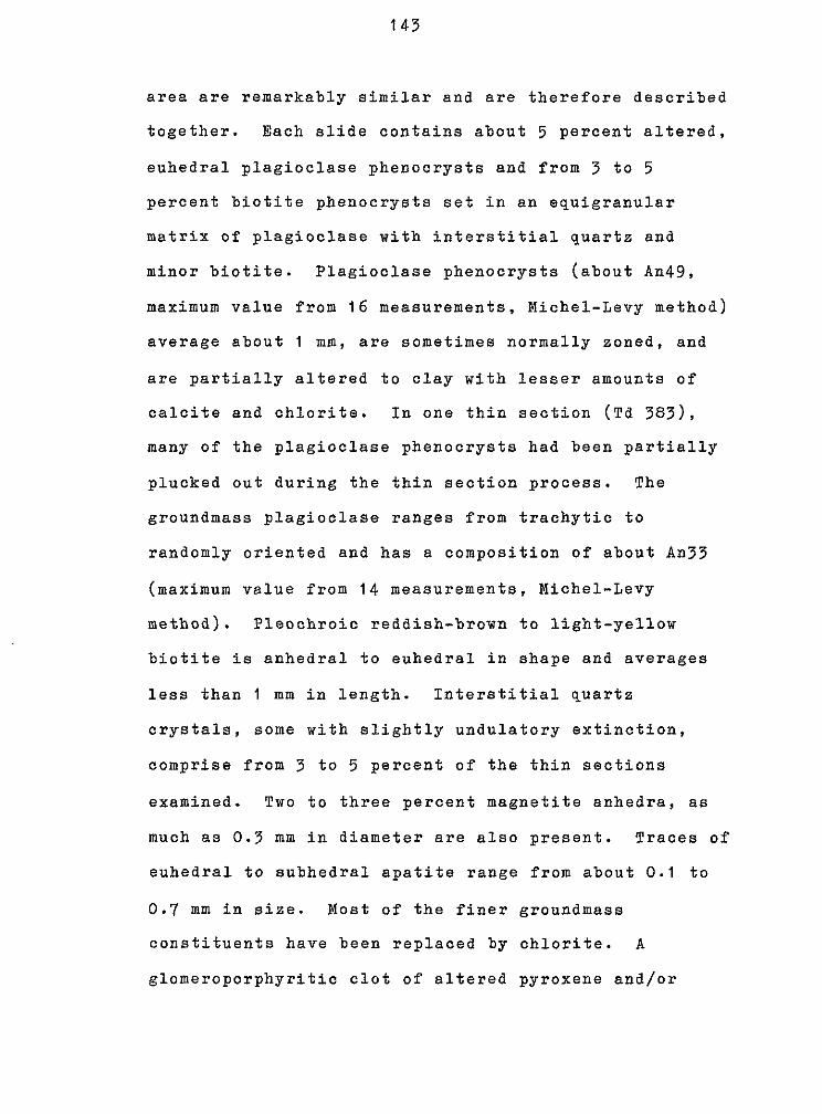
1 4 7
area are remarkably similar and are therefore described
together. Each slide contains about 5 percent altered,
euhedral plagioclase phenocrysts and from 3 to 5
percent biotite phenocrysts set in an equigranular
matrix of plagioclase with interstitial quartz and
minor biotite. Plagioclase phenocrysts (about An49,
maximum value from 1 6 measurements, Michel-Levy method)
average about 1 ma, are sometimes normally zoned, and
are partially altered to clay with lesser amounts o f
calcite and chlorite. In one thin section (Td 383),
many of the plagioclase phenocrysts had been partially
plucked out during the thin section process. The
groundmass plagioclase ranges from trachytic to
randomly oriented and has a composition of about An33
(maximum value from 1 4 measurements, Michel-Levy
method). Pleochroic reddish-brown to light-yellow
biotite is anhedral to euhedral in shape and averages
less than 1 mm in length. Interstitial quartz
crystals, some with slightly undulatory extinction,
comprise from 3 to 5 percent of the thin sections
examined. Two to three percent magnetite anhedra, as
much as 0.3 mm in diameter are also present. Traces of
euhedral to subhedral apatite range from about 0.1 to
0.7 mm in size. Most of the finer groundmass
constituents have been replaced by chlorite. A
glomeroporphyritic clot of altered pyroxene and/or

1 44
amphibole with biotite and apatite was seen in thin
section Td 383. The pyroxene and/or amphibole is
extensively replaced by hematite, calcite and chlorite.
Td 549 - Quartz Latite Plug
Sample Td 549 contains about 80 percent
plagioclase crystals which average less than 0.5 mm.
These subhedral to anhedral crystals have a composition
of about An39 (maximum value from 1 6 measurements,
Michel-Levy method) and are arranged in a pilotaxitic
array. The plagioclase is partially altered to
chlorite, calcite, and clay. Phenocrysts of an altered
ferromagnesian mineral, as much as 1 . 1 mm in size, make
up about 5 percent of the thin section. These crystals
have been completely replaced by chlorite, hematite,
and quartz; some have shapes diagnostic of amphibole,
others may be relict pyroxene. One to two percent
quartz crystals occur as interstitial grains and, less
often, as well-rounded phenocrysts with slightly
undulose extinction. The quartz phenocrysts are rimmed
by calcite. Anhedral sanidine crystals, altered in
part to illite, average less than 0.5 mm in size and
make up about 2 percent of the thin section. Traces of
biotite, plechroic from reddish brown to very light
brown, average about 0.05 mm in length. Magnetite
anhedra, present in amounts of 5 to 7 percent,

145
sometimes occur as inclusions within the ferromagnesian
minerals and the plagioclase. Traces of euhedral
apatitc dot the thin section. The groundmass is
altered t o irregular masses o f calcite and chlorite.

T h i s t h e s i s is a c c e p t e d on b e h a l f of t h e f a c u l t y of t h e


X T M
- " -- .- .. -
Jashed where approxlmately Faulf Iokated,
short dashed where inferred, dofted where concealed
Bar,and ball on downthrown side ts wlth posslble early- Oligocene movement with hachures on downthrown slde) r Indlcates, In feet, approxlmate stratigraphic throw
Dlkes and plugs Tqd: Quattz latite dike w plug Tmd: MaRc dike TdP: Intensdy altered dike (?)
9 Quartz - carbonate vein
x Prospect