c o p e r n i c u s - sorakoto.space€¦ · c o p e r n i c u s general overview disclaimer: the...
TRANSCRIPT

Copernicus EU
@CopernicusEU www.copernicus.eu
Copernicus EU
C o p e r n i c u s General Overview
Disclaimer: The views expressed are purely those of the speaker and may not in any circumstances be interpreted as stating an official position of the European Commission or the EEAS.

Copernicus
C O P E R N I C U S I N B R I E F
• Copernicus, a flagship programme of the European Union:
– Monitors the Earth, its environment and ecosystems
– Prepares for crises, security risks and natural or man-made disasters
– Contributes to the EU’s role as a global soft power
• Adopts a full, free and open data policy
• Is a tool for economic development and a driver for the digital economy
2

Copernicus
C O P E R N I C U S H I S T O R Y
1998
2001
2005
2006
2008
2011
2013
2014
Baveno Manifesto
Gothenburg EU Summit
GMES –Flagship of EU Space Policy
EC - GMES Bureau
EC-ESA Agreement on
GMES
Copernicus Regulation and Data
Policy
Start of GMES GIO
Start ofFull service operations
GMES Copernicus
GIO = GMES Initial Operation3

Copernicus
C O P E R N I C U S G O V E R N A N C E
4

Copernicus
T H E S E N T I N E L SSentinel Mission and Status Key Features
SENTINEL-1: 9-40m resolution, 6 days revisit at equator
Polar-orbiting, all-weather, day-and-night radar imaging
S1-A and B in orbit
SENTINEL-2: 10-60m resolution, 5 days revisit time
S2-A in OrbitS2-B in Orbit
Polar-orbiting, multispectral optical, high-res imaging
SENTINEL-3: 300-1200m resolution, <2 days revisit
S3-A in OrbitS3-B Launch
2018
Optical and altimeter mission monitoring sea and land parameters
SENTINEL-4: 8km resolution, 60 min revisit time
1st Launch Q4 2022
Payload for atmosphere chemistry monitoring on MTG-S
SENTINEL-5p: 7-68km resolution, 1 day revisit
S5-p in Orbit
Mission to reduce data gaps between Envisat, and S-5
SENTINEL-5: 7.5-50km resolution, 1 day revisit
1st Launch in 2021
Payload for atmosphere chemistry monitoring on MetOp 2ndGen
SENTINEL-6: 10 days revisit time
July 2020Radar altimeter to measure sea-surface height globally
5

Copernicus
T H E C O N T R I B U T I N G M I S S I O N S
6

Copernicus
I N - S I T U : O V E R V I E W
• In situ data = observation data from ground-, sea-, or air-borne sensors, reference and ancillary data licensed for use in Copernicus
• Use of In situ data:
– Validate & calibrate Copernicus products
– Reliable information services
• Implementation in two tiers:
– Tailored in situ data for each Copernicus service level
– Cross-cutting coordination across services by the EEA
7

Copernicus
C O P E R N I C U S S E R V I C E S
8
C O P E R N I C U S S E R V I C E S
Copernicus
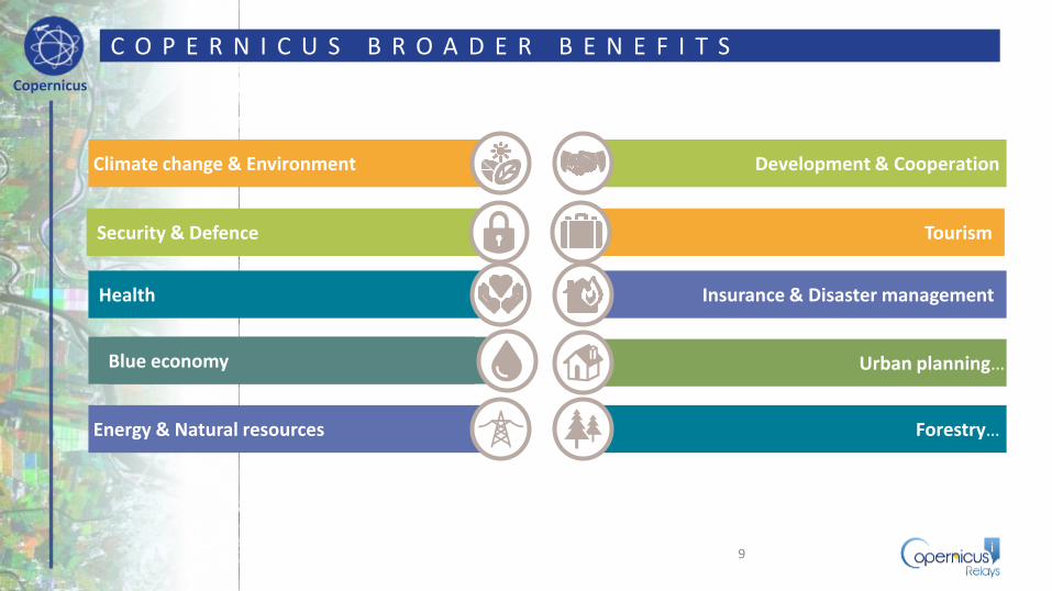
TourismSecurity & Defence
Energy & Natural resources Forestry…
Urban planning…Blue economy
Climate change & Environment Development & Cooperation
Health Insurance & Disaster management
C O P E R N I C U S B R O A D E R B E N E F I T S
9

Copernicus
C O P E R N I C U S I S D R I V E N B Y T H E U S E R S
10

Copernicus
C O P E R N I C U S M O N E T A R Y B E N E F I T S
* The Downstream and end user analysis includes only 8 value chains: Agriculture, Forestry, Urban Monitoring, Insurance, OceanMonitoring, Oil & Gas, Renewable Energies and Air Quality. Estimates for end users were only calculated for Insurance, Oil&Gas and UrbanMonitoring. The estimates of downstream and end user benefits should be seen as extremely conservative because they were calculateda year after the launch of the first Sentinel satellite. Benefits are likely to increase significantly as more Sentinels become operational.
Estimated direct monetary benefits between 2008 and 2020

Copernicus
E X A M P L E O F C O P E R N I C U S B E N E F I T S
Source: EARSC
Benefits for Sweden: €16 to €22 M/year
Benefits for the Netherlands:
€15 to €18 M/year
Benefits for Sweden and Finland:
€24 to €106 M/year
Pipeline Infrastructure Monitoring in the
Netherlands
Forest Management in Sweden
Winter Navigation in the Baltic
12

Copernicus
A g r i c u l t u r e s e c t o r : E x a m p l e s o f b e n e f i t s
More affordable applications based on Free Sentinels 1 and 2 Data and the Land Service Products
• Precision farming applications such as yieldmapping, input management, farm managementrecording, etc.
• Seasonal mappings of cultivated areas• Field scale and crop dynamics mapping• Irrigation management and drought monitoring• Food security monitoring• Agriculture development in Africa
Better quality food production
€€
€
€
€€
€ More efficient use of agricultural inputs
More efficient and appropriate use of fertilizers
€78M
€ Expected Copernicus enabled revenues
13Sources: PwC-Strategy& analysis & European Commission

Copernicus
C O P E R N I C U S U S E R U P T A K E S T R A T E G Y
Promote the uptake of Copernicus data and services
Ensure Access
1
BoostInnovation
2
Increase AwarenessAnd Use
3
Upstream & Midstream
Downstream Users
14

Copernicus
C O P E R N I C U S D A T A A C C E S S : K E Y L I N K S
Access to Satellite data
https://scihub.copernicus.eu/
• Land-related data: http://land.copernicus.eu• Atmosphere-related data: http://atmosphere.copernicus.eu• Marine-related data: http://marine.copernicus.eu• Emergency-related data: http://emergency.copernicus.eu• Climate change-related data: http://climate.copernicus.eu (Beta version)
Access to Copernicus Services Data
(*) Includes instructions on how to access Contributing Missions data15
https://spacedata.copernicus.eu/
• Copernicus Online Data Access (CODA)
• EUMETCast: www.eumetcast.com
Needs to get a station and pay a yearly fee
Copernicus Space Component Data Access Portal*
CSC-DA

Copernicus
C O P E R N I C U S B I G D A T A A P P R O A C H
Dual approach:
• Strong Copernicus Distribution Services for download
• Imminent launch of several Data Access and Information Services (DIAS)
– Access to all Copernicus data and information collocated with computing resources
– Big Data analytics without the need to download the data and information
– Data fusion with non-EO data and information
Overall ensuring that Copernicus data is easily accessible and used!
16

Copernicus
O P P O R T U N I T I E S F O R E U - J A P A N C O O P E R A T I O N
• Cooperation on Earth observation data exchange
17
• CEOS chairmanship by European Union in 2018
• EO industry cooperation, JSS as Copernicus Relay
SPACE
• Horizon 2020– EU Research programme open to participants across the world

Copernicus
C O N C L U S I O N S
18

Copernicus EU
Copernicus EU www.copernicus.eu
Copernicus EU
Thank you!