c umulative i mpacts a nalysis - washington … · umulative i mpacts a nalysis for the c ity of w...
TRANSCRIPT
WALLA WALLA COUNTY GRANT NO. G1400495
C U M U L A T I V E I M P A C T S A N A L Y S I S
FOR THE CITY OF WAITSBURG SHORELINE MASTER PROGRAM
Prepared for: Prepared by:
November 2015
The Watershed Company
Reference Number: 121109
STRATEGY | ANALYSIS | COMMUNICATIONS
2025 First Avenue, Suite 800 Seattle WA 98121
This report was funded in part through a grant from the Washington Department of Ecology.
City of Waitsburg 147 Main Street P.O. Box 35 Waitsburg, WA 99361
Cite this document as:
The Watershed Company and BERK. November 2015. Cumulative Impacts Analysis for the City of Waitsburg’s Shoreline Master Program. Prepared for the
City of Waitsburg.
The Watershed Company Contacts: Dan Nickel
BERK Contact:
Kevin Gifford
i
T A B L E O F C O N T E N T S Page #
1 Introduction ............................................................................... 1
1.1 Background and Purpose ............................................................................. 1 1.2 Approach ....................................................................................................... 3
2 Summary of Existing Conditions ............................................. 4
2.1 Environmental ............................................................................................... 4
2.1.1 Watershed Overview ....................................................................................... 4 2.1.2 City of Waitsburg ............................................................................................. 5
2.1 Land Use ........................................................................................................ 6
3 Reasonably Foreseeable Future Development ....................... 6
4 Effects of Established Regulatory Programs .......................... 7
4.1 Current City of Waitsburg Regulations ....................................................... 7
4.1.1 Critical Areas Regulations .............................................................................. 7 4.1.2 Zoning Code ..................................................................................................... 8
4.2 State Agencies/Regulations ......................................................................... 8
4.2.1 Washington Department of Natural Resources ............................................ 8 4.2.2 Washington Department of Ecology.............................................................. 9 4.2.3 Washington Department of Fish and Wildlife ............................................... 9
4.3 Federal Agencies/Regulations ..................................................................... 9
4.3.1 Clean Water Act ............................................................................................... 9 4.3.2 Federal Endangered Species Act (ESA) ...................................................... 10 4.3.3 Pacific Northwest Electric Power Planning and Conservation Act .......... 11
5 Cumulative Impacts with Application of the SMP ................. 11
5.1 Environment Designations ......................................................................... 12 5.2 Effects of Critical Areas Regulations ......................................................... 14
5.2.1 Wetlands ......................................................................................................... 14

ii
5.2.2 Streams ........................................................................................................... 15
5.3 Mitigation Sequencing ................................................................................ 16 5.4 Unregulated, Illegal and Exempt Development ......................................... 16 5.5 Effects of SMP Standards on Commonly Occurring Foreseeable Uses . 17 5.6 Shoreline Restoration Plan ........................................................................ 19
6 Net Effect on Ecological Function ......................................... 20
7 References ............................................................................... 21
L I S T O F F I G U R E S Page #
Figure 1-1. Framework for achieving no net loss of shoreline ecological functions (Source: Department of Ecology) ............................................................. 2
Figure 5-1. Distribution of upland environment designations in Waitsburg by area ... 14
L I S T O F T A B L E S Page #
Table 5-1. Environment designation criteria ............................................................ 13
The Watershed Company and BERK November 2015
1
C U M U L AT I V E I M PA C T S A N A LY S I S CITY OF WAITSBURG SHORELINE MASTER PROGRAM
1 INTRODUCTION 1.1 Background and Purpose
This Cumulative Impacts Analysis (CIA) is a required element of the City of Waitsburg’s Shoreline Master Program (SMP) update process. The State Master Program Approval/Amendment Procedures and Master Program Guidelines (SMP Guidelines; WAC 173-26-186(8)(d)) state that, “To ensure no net loss of ecological functions and protection of other shoreline functions and/or uses, master programs shall contain policies, programs, and regulations that address adverse cumulative impacts and fairly allocate the burden of addressing cumulative impacts.” The CIA is intended to demonstrate that an SMP will not result in degradation of shoreline ecological functions over a 20-year planning horizon. This CIA can help the City of Waitsburg (City or Waitsburg) make adjustments where appropriate in its proposed SMP if there are potential gaps between maintaining and degrading ecological functions.
In accordance with the SMP Guidelines, this CIA addresses the following:
i. “current circumstances affecting the shoreline and relevant natural processes [Chapter 2 below and Final Shoreline Analysis Report for Shorelines in Walla Walla County and the Cities of Walla Walla, Prescott and Waitsburg (The Watershed Company, BERK and the Walla Walla Basin Watershed Council 2014)];
ii. reasonably foreseeable future development and use of the shoreline [Chapter 3 below and Shoreline Analysis Report]; and
iii. beneficial effects of any established regulatory programs under other local, state, and federal laws.” [Chapter 4 below]
The CIA assesses the policies and regulations in the draft SMP to determine whether no net loss of ecological function will be achieved as new development occurs. The baseline against which changes in ecological function are measured

City of Waitsburg Cumulative Impacts Analysis
2
is the current shoreline conditions documented in the Final Shoreline Analysis Report for Shorelines in Walla Walla County and the Cities of Walla Walla, Prescott and Waitsburg (Shoreline Analysis Report, The Watershed Company, BERK, and the Walla Walla Basin Watershed Council 2014). For those projects or activities that result in degradation of ecological functions, the proposed SMP requires mitigation which must return the resultant ecological function back to the baseline. This is illustrated in Figure 1-1.
Figure 1-1. Framework for achieving no net loss of shoreline ecological functions
(Source: Department of Ecology)
Despite SMP regulations that require avoidance, minimization, and mitigation for any unavoidable losses of function, some uses and developments cannot be fully mitigated. This could occur when mitigation is out-of-kind, meaning that it offsets a loss of function through an approach that is not directly comparable to the proposed impact. A loss of functions may also occur when impacts are sufficiently minor on an individual level, such that mitigation is not required, but are cumulatively significant. Unregulated activities (such as operation and maintenance of existing legal developments) may also degrade baseline conditions. Additionally, the Waitsburg SMP applies only to activities in shoreline jurisdiction, yet activities upland of shoreline jurisdiction or upstream in the watershed may have offsite impacts on shoreline functions.

The Watershed Company and BERK November 2015
3
Together, these different project impacts may result in cumulative, incremental, and unavoidable degradation of the overall baseline condition unless additional restoration of ecological function is undertaken. Accordingly, the Shoreline Restoration Plan is intended to be a source of ecological improvements implemented voluntarily that may help bridge a gap between minor cumulative, incremental, and unavoidable damages and no net loss of shoreline ecological functions.
1.2 Approach This CIA was prepared consistent with direction provided in the SMP Guidelines as described above. Existing conditions were first evaluated using the information, both textual and graphic, developed and presented in the Shoreline Analysis Report. Likely development identified in the Shoreline Analysis Report was addressed further to understand the extent, nature, and general location of potential impacts.
The effects of likely development were then evaluated in the context of SMP provisions, as well as other related plans, programs, and regulations. For the purpose of evaluating impacts, areas with a likelihood of high densities of new development or redevelopment were evaluated in greatest detail. Cumulative impacts were analyzed quantitatively where possible. A qualitative approach was used where specific details regarding redevelopment likelihood or potential were not available at a level that could be assessed quantitatively or the analysis would be unnecessarily complex to reach a conclusion that could be derived more simply.
While the initial Analysis Report was conducted regionally, the cities of Walla Walla, Prescott and Waitsburg are each developing separate proposed SMPs and will have separate CIAs prepared for each. The discussion in this CIA pertains only to Waitsburg.
2 SUMMARY OF EXISTING CONDITIONS Waitsburg’s shoreline jurisdiction encompasses approximately 157 acres of Touchet River shoreline, which, in accordance with state law, includes lands within 200 feet of the ordinary high water mark (OHWM) of the Touchet River,
City of Waitsburg Cumulative Impacts Analysis
4
as well as floodways, floodplain areas within 200 feet of a mapped floodway, and associated wetlands.
The following summary of existing baseline conditions in shoreline jurisdiction is based on the final Shoreline Analysis Report. More detailed information on the reach of the Touchet River through Waitsburg, as well as upstream and downstream conditions, is provided in the full report.
2.1 Environmental 2.1.1 Watershed Overview
Waitsburg is located within Water Resource Inventory Area (WRIA) 32, the Walla Walla watershed. The Walla Walla River originates in the Blue Mountains in Oregon at an elevation of approximately 6,250 feet. Major tributaries to the Walla Walla River within Walla Walla County include the Touchet River which runs through Prescott, and Mill Creek, including Yellowhawk Creek, which is a distributary braid of Mill Creek. The Touchet River drains the northern portion of the Walla Walla watershed. Mill Creek drains the majority of the southern portion of the watershed within Walla Walla County.
Precipitation is concentrated in the winter months, and varies depending on location in the watershed. Most flooding results from rain-on-snow events in the late winter and early spring. Many of the streams that are not fed by snowmelt dry up in the summer months.
The majority of the Walla Walla watershed consists of steppe or shrub-steppe vegetation. Common trees and shrubs in riparian areas of the Walla Walla watershed include cottonwood, alder, willow, and red osier dogwood (Snake River Salmon Recovery Board 2011). Riparian vegetation is usually restricted to narrow strips along rivers and streams. In the recent past the Conservation Reserve Enchantment Program (CREP) has led to native tree and shrub plantings, including some coniferous species, along many stream corridors. Uplands and foothills are dominated by dryland agriculture, with areas of intensive irrigated croplands adjacent to waterways. The Blue Mountains plateau and headwaters regions is predominantly dense conifer forests interspersed with steep grasslands sloping down to headwater streams.
The Touchet River flows through the middle of Walla Walla County. It enters from Columbia County and flows east through the Cities of Waitsburg and

The Watershed Company and BERK November 2015
5
Prescott before turning south and eventually joining the Walla Walla River in the southwest portion of the County, just southwest of the unincorporated town of Touchet. Shoreline functions are generally moderate to high throughout all reaches due to hydrologic complexity including floodway, wetlands, meanders and backwater areas and space and conditions supporting fish and wildlife species. Extensive floodplain is mapped through most of the Touchet River shoreline jurisdiction. Presence of anadromous fish species is documented throughout the river including Spring Chinook and Summer Steelhead, as well as presumed presence of bull trout in some reaches. The greatest impairments are found in the agricultural areas in the lower County reaches. In these areas, stream temperature and sediment load is impacted by poor riparian habitat, confinement, and poor floodplain and channel function.
For the purpose of the Analysis Report the Touchet River was divided into 9 reaches. Reaches 5 through 8 are in Waitsburg, Reach 4 is within the City of Prescott and the rest are in the unincorporated County. Conditions of the Waitsburg reaches are discussed further below. A detailed analysis and functional scoring for all reaches can be found in the Shoreline Analysis Report.
2.1.2 City of Waitsburg Four of the Touchet River reaches (Reaches 5-8), totaling approximately 157 acres, lie within City of Waitsburg boundaries. The majority of this land is owned by the City. Reach 8 through eastern Waitsburg is the least altered reach. The majority of the shoreline is unarmored in this area. Backwater areas, wetlands and dense riparian vegetation separates uplands from the river along most of the reach. Reaches 6 and 7 are slightly lower functioning due to more alterations from residential development, agriculture practices and areas with little riparian vegetation. Irrigation withdrawals for alfalfa production also occur in Reach 6.
Extensive floodplain and floodway areas are mapped within each of the four reaches and the city experienced significant flooding events in 1964 and 1996. Floodplain is mapped over 86% to 93% of the shoreline jurisdiction in each reach and floodway ranges from 51% to 58%. Levees are present along the majority of Reaches 5-7, which are used as a public trail. Currently Reach 8 also has a temporary levee along the north side. The levees alter natural hydrologic process and floodway connectivity. Additionally, the Corps has recently required vegetation removal along the levee, lowering vegetative shoreline function.

City of Waitsburg Cumulative Impacts Analysis
6
Priority habitat regions for Northwest White-tailed Deer and Ring-necked Pheasant are mapped within each of the reaches. Presence of Spring Chinook and Summer Steelhead is documented, as well as presumed presence of bull trout.
2.1 Land Use Current land use along the Touchet River in Waitsburg consists primarily of a mix of residential uses and undeveloped land, though the City’s shoreline jurisdiction also includes agriculture, commercial uses, government land, and cultural and entertainment uses. Residential development accounts for approximately 39% of the shoreline jurisdiction, followed by undeveloped land at 28%. While commercial uses (trade and services) only account for about 5% of the land area, it is important to note that the City’s shoreline jurisdiction encompasses a large portion of Downtown Waitsburg.
Water-dependent and water enjoyment uses in Waitsburg include Preston Park, which provides riverside recreation and public access. Transportation infrastructure includes city streets and a bridge crossing of the Touchet River by SR 12 just east of downtown.
3 REASONABLY FORESEEABLE FUTURE DEVELOPMENT
This section estimates potential future development within and along the shorelines of Waitsburg. Consistent with the State Guidelines (WAC 173-26-201), this estimate will identify reasonably foreseeable future development over the next 20 years. The estimate was derived using a land capacity analysis method which identified the total (or gross) vacant and underutilized land area.
Because no spatial data on local zoning is available for Waitsburg, analysis of future development potential was conducted at a qualitative level, focusing on existing land use patterns, lot configurations, the presence of vacant land, and environmental constraints.
Potential for future development within the shoreline jurisdiction of Waitsburg is heavily influenced by the presence of an extensive floodplain that covers portions of downtown, residential areas, and public open space along the

The Watershed Company and BERK November 2015
7
Touchet River. The City’s shoreline jurisdiction contains 31 vacant properties that could potentially be developed. While zoning data is not available in GIS format from the City of Waitsburg to conduct detailed analysis of development potential, visual review of the City’s zoning map indicates that the 31 vacant properties fall approximately into the following categories:
• 16 properties zoned for residential use that lie entirely within the flood hazard area. While these parcels are not prohibited from development, their location within the flood zone poses a substantial barrier.
• 1 property zoned for commercial use that lies entirely within the flood hazard area. This property is located adjacent to the railroad right-of-way and could potentially develop, though its location within the flood zone would pose a barrier to development.
• 4 properties zoned for residential use that lie entirely within the flood hazard area and which are designated as “Future Acquisition Properties” on the City’s land use/zoning map. Because these parcels have been targeted for probable acquisition by the City, these locations are unlikely to develop.
• 1 property zoned for residential use that lies entirely within the flood hazard district and which comprises approximately 0.03 acre. Given its small size and location within the flood hazard area, no future development is anticipated on this property.
• 2 properties zoned for utility use that lie entirely within the flood hazard area. These properties have a combined acreage of less than 0.5 acre and area almost entirely surrounded by WSDOT-owned land. As a result of these factors, development is highly unlikely.
• 1 property zoned for residential use that lies partially within the flood hazard area and which is owned by the Union Pacific Railway. As the railroad is unlikely to develop housing, development of this property would require a change in zoning or a sale to a private developer.
• 2 properties zoned “Flexible Commercial/Residential” that lie partially within the flood hazard area and which appear to be encumbered by slopes or the riverbed of the Touchet River itself. Due to these natural

City of Waitsburg Cumulative Impacts Analysis
8
features and lack of access in the area, it is unlikely these properties will be developed for either commercial or residential uses.
• 4 properties zoned for residential use that lie partially within the flood hazard area. While several of these properties are partially encumbered by the presence of slopes and the Touchet River channel, unencumbered areas are available for development. Combined, these 4 properties could potentially produce up to 15 new housing units, assuming subdivision in accordance with the local development code. However, because the portions of these properties that lie within shoreline jurisdiction are often encumbered by slopes and other natural hazards, much of this new housing would be located outside shoreline jurisdiction.
As described above, due to the extensive floodplain in Waitsburg and the high flood risk posed to local residents and businesses, it is unlikely that these vacant shoreline properties will develop to their full potential. FEMA is conducting a voluntary buy-out program in the area, and future development in shoreline jurisdiction is therefore anticipated to be limited.
4 EFFECTS OF ESTABLISHED REGULATORY PROGRAMS
4.1 Current City of Waitsburg Regulations 4.1.1 Critical Areas Regulations
City critical area regulations, which will continue to apply outside of shoreline jurisdiction after adoption of the SMP are contained in Chapter 10.2A of the Waitsburg Municipal Code (WMC). These regulations require a 25-foot buffer on the Touchet River and a 15-foot buffer on Coppei Creek. The regulations also establish a 15-foot buffer from the top and bottom of steep slopes exceeding 15 percent slope. WMC 10.2A.030 describes the City’s approach to regulating critical areas as follows,
“This Chapter addresses only those activities within the buffer zones on the Touchet River and the Coppei Creek, and geologically hazardous areas. The National Wetlands Inventory Maps show that all wetlands within the City and adopted Urban Growth Areas are directly associated with the Touchet River and
The Watershed Company and BERK November 2015
9
the Coppei Creek. These buffers along the Touchet and the Coppei also contain all of the wildlife habitat within the current City limits and adopted Urban Growth Area.”
4.1.2 Zoning Code City zoning standards (WMC Title 10, Article 10.1) direct the location of uses, building bulk, and scale. These standards are important in planning for future growth and focusing development in a sustainable manner.
4.2 State Agencies/Regulations Aside from the Shoreline Management Act, State regulations most pertinent to moderation of ecological impacts of development in the City’s shoreline include the State Hydraulic Code, the Growth Management Act, State Environmental Policy Act (SEPA), tribal agreements and case law, and Water Resources Act. A variety of agencies (e.g., Washington Department of Ecology, Washington Department of Fish and Wildlife, Washington Department of Natural Resources) are involved in implementing these regulations or managing state-owned lands. The Department of Ecology reviews all shoreline projects that require a shoreline permit, but has specific regulatory authority over Shoreline Conditional Use Permits and Shoreline Variances. Other agency reviews of shoreline developments are typically triggered by in- or over-water work, discharges of fill or pollutants into the water, or substantial land clearing. During the comprehensive SMP update, the City has considered other State regulations to ensure consistency as appropriate and feasible with the goal of streamlining the shoreline permitting process. A summary of some of the key State regulations by agency responsibilities follows.
4.2.1 Washington Department of Natural Resources Projects on state-owned aquatic lands may be required to obtain an Aquatic Use Authorization from Washington Department of Natural Resources (WDNR) and enter into a lease agreement. WDNR will review lease applications to determine if the proposed use is appropriate, and to ensure that proposed mitigation for impacts to aquatic resources are sufficient.
WDNR is also responsible for administering the Surface Mining Act. The Act requires a permit for each mine that: 1) results in more than 3 acres of mine-related disturbance, or 2) has a high-wall that is both higher than 30 feet and steeper than 45 degrees. A reclamation plan is required that describes how the

City of Waitsburg Cumulative Impacts Analysis
10
site will be restored following mining activity to maintain stable slopes, diverse landscape features, and dense, native vegetation. In coordination with SMP standards, the Act helps ensure that mining activities do not result in long-term adverse effects on shoreline functions.
4.2.2 Washington Department of Ecology The Washington Department of Ecology may review and condition a variety of project types, including any project that needs a permit from the U.S. Army Corps of Engineers (see below), any project that requires a Shoreline Conditional Use Permit or Shoreline Variance, and any project that disturbs more than 1 acre of land. Project types that may trigger Ecology involvement include pier and shoreline modification proposals and wetland or stream modification proposals, among others. Ecology’s three primary goals are to: 1) prevent pollution, 2) clean up pollution, and 3) support sustainable communities and natural resources (http://www.ecy.wa.gov/about.html). Ecology may comment on local SEPA review if it is an agency of jurisdiction.
4.2.3 Washington Department of Fish and Wildlife The Washington Department of Fish and Wildlife (WDFW) has the authority to review, condition, and approve or deny “any construction activity that will use, divert, obstruct, or change the bed or flow of State waters.” Practically speaking, these activities include, but are not limited to, installation or modification of piers, shoreline stabilization measures, culverts, and bridges. WDFW typically conditions such projects to avoid, minimize, and/or mitigate for damage to fish and other aquatic life, and their habitats.
4.3 Federal Agencies/Regulations Federal review of shoreline development is in most cases triggered by in- or over-water work, or discharges of fill or pollutants into the water. Depending on the nature of the proposed development, federal regulations can play an important role in the design and implementation of a shoreline project, ensuring that impacts to shoreline functions and values are avoided, minimized, and/or mitigated. A summary of some of the key federal regulations follows.
4.3.1 Clean Water Act Major components of the Clean Water Act include Section 404, Section 401, 303(d) and the National Pollutant Discharge Elimination System (NPDES).
The Watershed Company and BERK November 2015
11
Section 404 provides the Corps, under the oversight of the U.S. Environmental Protection Agency, with authority to regulate “discharge of dredged or fill material into waters of the United States, including wetlands” (http://www.epa.gov/owow/wetlands/pdf/reg_authority_pr.pdf). The extent of the Corps’ authority and the definition of fill have been the subject of considerable legal activity. As applicable to the City’s shoreline jurisdiction, however, it generally means that the Corps must review and approve many activities in streams, lakes and wetlands. These activities may include wetland fills, stream and wetland restoration, and culvert installation or replacement, among others. The Corps requires projects to avoid, minimize, and compensate for impacts.
A Section 401 Water Quality Certification is required for any applicant for a federal permit for any activity that may result in any discharge to waters of the United States. States and tribes may deny, certify, or condition permits or licenses based on the proposed project’s compliance with water quality standards. In Washington State, the Department of Ecology has been delegated the responsibility by the U.S. Environmental Protection Agency for managing implementation of this program.
The NPDES is similar to Section 401, and it applies to ongoing point-source discharge. Permits include limits on what can be discharged, monitoring and reporting requirements, and other provisions designed to protect water quality. Examples of discharges requiring NPDES permits include municipal stormwater discharge, wastewater treatment effluent, or discharge related to industrial activities or aquaculture facilities.
Section 303(d) of the Clean Water Act requires the state to develop a list of waters that do not meet water quality standards. A Total Maximum Daily Load, or TMDL, must be developed for impaired waters. Portions of the Touchet River through Waitsburg have a TMDL for pH.
The Inventory Data Summary Table in Appendix C of the Shoreline Analysis Report identifies impaired water quality listings in the City by shoreline reach.
4.3.2 Federal Endangered Species Act (ESA) Section 9 of the Endangered Species Act prohibits “take” of federally listed species (see Table 3-1 in the Shoreline Analysis Report), and this prohibition applies to all parties anywhere that those listed species may be found, both in

City of Waitsburg Cumulative Impacts Analysis
12
and outside of shoreline jurisdiction. Per Section 7 of the ESA, the Corps must consult with the National Marine Fisheries Service and the U.S. Fish and Wildlife Service on any projects that fall within Corps jurisdiction (e.g., Section 404 or Section 10 permits) that could affect species listed under the Federal Endangered Species Act. These agencies ensure that the project includes impact minimization and compensation measures for protection of listed species and their habitats.
4.3.3 Pacific Northwest Electric Power Planning and Conservation Act Congress established the Northwest Power Act in 1980, which established the Northwest Power and Conservation Council with the goals of preparing and adopting (1) a regional conservation and electric power plan and (2) a program to protect, mitigate, and enhance fish and wildlife. As a member of the Walla Walla Watershed Planning Unit, Walla Walla County contributed to the preparation of the Walla Walla Subbasin Plan in 2004, prepared for the Northwest Power and Conservation Council. The Subbasin Plan describes to the Council the most effective ways that the Council and the Bonneville Power Administration (BPA) can meet their obligations in the Walla Walla Subbasin to mitigate the impacts on fish and wildlife resources from the construction and operation of the Federal Columbia River Power System (FCRPS). Because dam impacts are ongoing and integrated into the analysis of the environmental baseline conditions, as mitigation for dam impacts is implemented, the environmental baseline conditions are expected to improve (see Shoreline Restoration Plan for more specific description of proposed actions).
5 CUMULATIVE IMPACTS WITH APPLICATION OF THE SMP
This section describes how, based on the foreseeable development, the proposed SMP protects shoreline functions. The following components of the SMP are integral to ensuring no net loss of shoreline functions. Each of these components is discussed in further detail below.
• Shoreline environment designations are based on existing shoreline conditions. Allowed uses focus higher-intensity development in areas

The Watershed Company and BERK November 2015
13
with a high level of existing alterations, while limiting future uses in areas where ecological functions and processes are more intact.
• SMP standards require applicants to avoid, minimize, and then compensate for unavoidable impacts to shoreline functions. Where SMP standards do not provide specific, objective measures that clarify avoidance, minimization, and mitigation measures, a mitigation sequencing analysis is required.
• Shoreline critical areas regulations are consistent with recommended state guidance to maintain ecological functions.
• Specific policies and regulations govern shoreline uses and modifications and ensure that potential impacts are regulated to avoid a net loss of ecological function, while also meeting the requirements of the Shoreline Management Act pertaining to public access, prioritization of shoreline uses, and private property rights.
5.1 Environment Designations The assignment of environment designations can help minimize cumulative impacts by concentrating development activity in lower functioning areas or areas with more intensive existing development that are not likely to experience significant function degradation with incremental increases in new development or redevelopment. According to the SMP Guidelines (WAC 173-26-211), the assignment of environment designations must be based on the existing use pattern, the biological and physical character of the shoreline, and the goals and aspirations of the community as expressed through a comprehensive plan.
Consistent with SMP Guidelines, the City’s environment designation system is based on the existing use pattern, the biological and physical character of the shoreline, and community interests. The Shoreline Analysis Report provided information on shoreline conditions and functions that informed the development of environment designations. The proposed environment designations include: High Intensity, Urban Residential and Urban Conservancy, generally listed in order by decreasing intensity of allowed use. Criteria for each environment designation are provided in Table 5-1.

City of Waitsburg Cumulative Impacts Analysis
14
Table 5-1. Environment designation criteria
Environment Designation Classification Criteria
High Intensity Areas within urban growth areas and existing industrial, commercial, and multi-family residential areas if they currently support high-intensity uses related to multi-family residences, commerce, transportation or navigation; or are suitable and planned for high-intensity water-oriented uses.
Urban Residential
Areas within city limits or urban growth areas that include existing residential development, or are planned or platted for residential development.
Urban Conservancy
Areas within city limits or UGAs that: 1. Are planned for development that is compatible with the principles of maintaining or restoring the ecological functions of the area; 2. Are suitable for water related and water-enjoyment uses; 3. Are open space or; 4. Are areas that retain important ecological functions which should not be more intensively developed.
Aquatic Areas waterward of the ordinary high-water mark.
Almost three quarters of the shoreline area within Waitsburg occurs in the Urban Conservancy environment designation (Figure 1), which is designed to protect and restore ecological functions of open space, floodplain and other sensitive lands where they exist in urban and developed settings, while allowing a variety of compatible uses. The remaining shoreline area is divided between the Urban Residential and High Intensity designations.
The proposed environment designations reflect the rural-agricultural nature of the City, and the extensive floodplain present which restricts development through much of the City. The environment designations appropriately focus potential high intensity development activity in existing disturbed areas with higher levels of alterations and lower ecological functions compared to other reaches. Those existing disturbed shorelines are not likely to experience significant function degradation with incremental increases in new development. The Urban Conservancy designation helps protect the less developed, more agricultural and rural shorelines where some shoreline functions are more intact.

The Watershed Company and BERK November 2015
15
Figure 5-1. Distribution of upland environment designations in Waitsburg by area
5.2 Effects of Critical Areas Regulations The SMP includes policies and regulations to avoid cumulative effects to critical areas. The Waitsburg SMP incorporates the County’s existing critical areas regulations (WWCC 18.08) as an appendix, minimally revised to be compliant with SMA requirements and the most current, accurate and complete scientific and technical information available. These regulations will apply only to all critical areas within shoreline jurisdiction while the City’s critical areas regulations in WMC 10.2A will continue to apply outside of shoreline jurisdiction. The SMP requires mitigation sequencing for all shoreline critical areas including wetlands; critical aquifer recharge areas; frequently flooded areas; geologically hazardous areas; and fish and wildlife habitat conservation areas, which includes streams. SMP regulations proposed for wetlands and streams include standard buffer areas, which are discussed in greater detail below.
5.2.1 Wetlands The SMP requires vegetated buffers for all shoreline wetlands. Mitigation sequencing is required for impacts to wetland buffers, as well as to wetlands. The proposed standard wetland buffer widths are based on the wetland category and intensity of proposed land use and are consistent with Ecology’s “Wetlands in Washington State-Volume 2: Guidance for Protecting and Managing Wetlands,” modified to use with the 2014 Washington State Rating System for Eastern Washington (Granger et al. 2005, modified 2014) which relies on the most current technical and scientific information available. Buffer averaging may be

City of Waitsburg Cumulative Impacts Analysis
16
permitted to improve wetland protection, provided that the averaging will not result in degradation of the wetland’s functions (SMP Appendix A, Section 3.7). The SMP Administrator may increase the width of the standard buffer width on a case-by-case basis, based on a critical area report, when a larger buffer is required to protect the wetland (SMP Appendix A, Section 3.8). The SMP Administrator also has the authority to reduce standard wetland buffer widths provided mitigation sequencing is followed and the buffer reduction does not adversely affect the functions and values of the adjacent wetlands (SMP Appendix A, Section 3.9). As each individually permitted project must prove no adverse effect to function, the cumulative effect of these regulations will be to maintain, or enhance the baseline condition. Mitigation for impacts must also include five years of monitoring to ensure success of the mitigation’s goals, objectives and performance standards (SMP Appendix A, Section 3.11(D)). These proposed SMP standards should ensure that wetland functions are maintained over time.
5.2.2 Streams Regulations for streams are contained within the Fish and Wildlife Habitat Conservation Areas section of the SMP critical areas regulations. The proposed SMP establishes riparian habitat buffers on shoreline streams that are consistent with those in the County’s existing critical areas regulations. For the Touchet River a 100 foot buffer is proposed.
For non-shoreline tributaries within shoreline jurisdiction, buffers range from 35 to 100 feet depending on the existing conditions and targeted functions of the waterbody.
Stream buffer averaging may be allowed on a case by case basis provided certain criteria are met (SMP Appendix A, Section 6.10). Stream buffers may also be reduced, on a case by case basis, provided that certain criteria are met including that the buffer reduction shall not adversely affect the habitat functions and values of the adjacent habitat conservation area or other critical area, and that a habitat enhancement plan is prepared by a qualified professional. The habitat enhancement plan must demonstrate that it will improve riparian functions over existing conditions (SMP Appendix A, Section 6.12).
Water dependent developments have no buffer requirement due to the nature of the activity which necessitates that the development be adjacent to the shoreline. However, mitigation sequencing must still be followed which will ensure no net

The Watershed Company and BERK November 2015
17
loss of function through compensation of unavoidable impacts (See Section 5.3, below).
Within regulated buffer areas, only limited, minimally invasive modifications are allowed, including a 4-foot-wide residential access pathway to the water, water-dependent uses and certain accessories, and water oriented public access and recreation facilities provided that the design applies mitigation sequencing and appropriate mitigation is provided to ensure no net loss of ecological functions (SMP Appendix B, Section 6.5(B)(5)).
In addition to the buffers discussed above, a five foot building setback, starting from the landward edge of the critical area buffer of a shoreline waterbody, is also proposed (SMP Section 6.2(D)). Further discussion of the implications of specific buffer and setback regulations in relation to anticipated shoreline uses is integrated into Section 5.5, below.
5.2.3 Flood Hazard Areas The SMP requires that new development be located outside of floodways and avoid location in floodplains so as not to significantly or cumulatively increase flood hazards (SMP Section 5.5(A)). Development shall be consistent with the SMP, including Appendix A, Section 4.0, Frequently Flooded Areas, as well as the City’s Article 10.7 (Flood Hazard Areas) which regulate proposed activities adjacent to or within frequently flooded areas. If allowed, any structures permitted in the designated flood areas in shoreline jurisdiction are subject to the flood-proofing regulations provided in Article 10.7, as well as the flood protection measures of this Section and applicable guidelines of the Federal Emergency Management Agency and an approved flood hazard management plan. The City’s Article 10.7 Flood Hazard Area regulations are referenced in both the Frequently Flooded Area critical area regulations in Appendix A and the Flood Protection regulations in SMP section 5.5.
5.3 Mitigation Sequencing The proposed SMP includes general regulations requiring projects to be designed, located, sized, constructed and maintained to achieve no net loss of shoreline ecological functions (5.1(A), Ecological Functions). Mitigation sequencing standards apply to all projects in shoreline jurisdiction. In some cases, specific provisions are applied by the SMP that stipulate objective standards for avoiding (e.g., placement), minimizing (e.g., size, materials, and

City of Waitsburg Cumulative Impacts Analysis
18
design standards), and compensating for unavoidable impacts (e.g. specific planting requirements). Where these objective standards are not specified in the SMP, a description of the analysis of mitigation sequencing is required with any shoreline application ((5.1(C), Mitigation Requirement and 5.1(D), Mitigation Sequence). The application of mitigation sequencing standards should help ensure that shoreline uses and modifications achieve no net loss of shoreline ecological functions.
5.4 Unregulated, Illegal and Exempt Development Unregulated Uses
Unregulated shoreline activities include activities that are not “development” and do not require any sort of shoreline permit, including a shoreline exemption. Typically, these unregulated activities involve everyday maintenance and use of shoreline lands in conjunction with an approved land use (e.g., applying fertilizer in a residential yard, driving a car on a road along the shoreline, using a boat that is moored at a dock or launched at a boat ramp). Because these activities are associated with legally permitted land uses, the potential effects of these unregulated uses are addressed in concert with the analysis of land uses below.
Illegal Uses
Illegal activities are expected to occur infrequently in shoreline jurisdiction. Where illegal actions are identified, they are required to be rectified. Where illegal actions are not recognized, they may result in an incremental loss of shoreline functions. These incremental losses are expected to be offset by mitigation requirements for approved shoreline modifications that result in minor improvements over time (see Appendix A), as well as by voluntary restoration actions identified in the Shoreline Restoration Plan.
Exempt Development
Development and activities that are exempt from requirements for a shoreline substantial development permit are specified in WAC 173-27-040. The SMP explicitly states that development qualifying for a shoreline exemption must still comply with all SMP policies and regulations. Because the SMP provides specific design standards for many exempt developments (such as shoreline stabilization to protect a residence, or a dock) and require that all exempt development types avoid, minimize, and compensate for shoreline impacts, exempt development is not expected to result in a net loss of shoreline functions.
The Watershed Company and BERK November 2015
19
5.5 Effects of SMP Standards on Commonly Occurring Foreseeable Uses
The SMP contains numerous shoreline use regulations intended to protect the ecological functions of the shoreline and prevent adverse cumulative impacts (See Chapter 6.0, Shoreline Use and Modification Polices and Regulations as well as general regulations under Subsections 5.1- Ecological Protection and Critical Areas, 5.2-Water Quality and 5.3-Vegetation Conservation). As discussed previously, WAC 173-26-186(8)(d) directs local SMPs to evaluate and consider cumulative impacts of “reasonably foreseeable future development on shoreline ecological functions.” Although future development may include other less common types of development, the location, timing, and impacts of less common uses and development projects are less predictable. WAC 173-26-201(3(d)(iii) states:
For those projects and uses with unanticipatable or uncommon impacts that cannot be reasonably identified at the time of master program development, the master program policies and regulations should use the permitting or conditional use permitting processes to ensure that all impacts are addressed and that there is not net loss of ecological function of the shoreline after mitigation.
Results of the analysis of foreseeable future development in Section 3 indicate that most of the currently undeveloped properties in shoreline jurisdiction are zoned for residential use. However, due to the extensive floodplain in the area and the high flood risk posed to local residents and businesses, it is unlikely that these vacant properties will develop to their full potential. FEMA is conducting a voluntary buy-out program in the area, and future development in shoreline jurisdiction is therefore anticipated to be limited.
New residential development is associated with an increase in stormwater runoff and water quality impacts resulting from an increase in impervious surfaces; greater potential for increased erosion, bank instability, and turbidity associated with vegetation clearing; loss or disturbance of riparian habitat during upland development; reduced shoreline habitat complexity; and increased water temperatures.
New single-family residential development is permitted with a Shoreline Substantial Development Permit (or Shoreline Exemption) in all upland environment designations in Waitsburg except for High Intensity, where it is
City of Waitsburg Cumulative Impacts Analysis
20
prohibited. Multi-family residential development is also permitted with a Shoreline Substantial Development Permit in all upland environment designations.
New residential development must meet all applicable critical area (include frequently flooded area), vegetation, and water quality standards of the SMP; be sufficiently set back from steep slopes and shorelines vulnerable to erosion; and be located, designed, and constructed in a manner that assures no net loss of shoreline ecological functions (SMP Section 6.17).
A complete review of the potential impacts of all shoreline uses and modifications included in the SMP, including those less commonly anticipated to occur in Waitsburg, and the SMP standards that manage the resulting impacts, can be found in Appendix A of this CIA.
5.6 Shoreline Restoration Plan One of the key objectives that the SMP must address is “no net loss of ecological functions necessary to sustain shoreline natural resources” (Ecology 2011). Although the implementation of restoration actions to restore historic functions is not required by SMP provisions, the SMP Guidelines state that “master programs shall include goals, policies and actions for restoration of impaired shoreline ecological functions. These master program provisions should be designed to achieve overall improvements in shoreline ecological functions over time, when compared to the status upon adoption of the master program” (WAC 173-26-201(2)(f)).
The Shoreline Restoration Plan (TWC 2015) represents a long-term vision for restoration that will be implemented over time, resulting in a gradual improvement over the existing conditions. Although the SMP is intended to achieve no net loss of ecological functions through regulatory standards alone, practically, an incremental loss of shoreline functions at a cumulative level may occur through minor, exempt development; illegal development; failed mitigation efforts; or a temporal lag between the loss of existing functions and the realization of mitigated functions. The Shoreline Restoration Plan, and the voluntary actions described therein, can be an important component in making up that difference in ecological function.

The Watershed Company and BERK November 2015
21
Major Shoreline Restoration Plan components that are expected to contribute to improvement in ecological functions in the foreseeable future are summarized below:
• Implementation of best management practices and design projects to improve stream flow, fish passage and floodplain connectivity
• Coordination with landowners to implement voluntary riparian and floodplain enhancement projects through acquisition, easement, or conservation agreements.
6 NET EFFECT ON ECOLOGICAL FUNCTION
This CIA indicates that future growth is likely to be limited in Waitsburg, and would be targeted in certain areas of the shoreline. This analysis can help inform the City of potential future shoreline impacts and the importance of specific proposed SMP provisions.
The proposed SMP is expected to maintain existing shoreline functions within Waitsburg while accommodating the reasonably foreseeable future shoreline development. Other local, state and federal regulations, acting in concert with this SMP, will provide further assurances of maintaining shoreline ecological functions over time. The Shoreline Restoration Plan, and actions described therein, will ensure that incremental losses that could occur despite SMP provisions do not result in a net loss of functions, and these restoration actions may result in a gradual improvement in shoreline functions.
As discussed above, major elements of the SMP that ensure no net loss of ecological functions fall into four general categories: 1) environment designations, 2) general policies and regulations, 3) shoreline critical areas regulations, and 4) shoreline use and modification provisions. The Shoreline Restoration Plan identifies ongoing and planned voluntary restoration that will provide an opportunity to improve shoreline conditions over time.
Environment designations: The Shoreline Analysis Report provided the information necessary to assign environment designations by segment to each of the shoreline waterbodies (SMP Section 4.0).

City of Waitsburg Cumulative Impacts Analysis
22
General provisions: SMP Section 3.0 contains a number of goals pertaining to the protection and restoration of ecological functions. SMP Section 5.0 contains policies and regulations designed to achieve those goals. These regulations include provisions that provide the basis for achieving no net loss of shoreline functions, such as mitigation sequencing and vegetation conservation standards.
Shoreline modification and use provisions: SMP Section 6.0 contains a number of regulations that contribute to protection and restoration of ecological functions. Shoreline uses and modifications were individually determined to be either permitted (as substantial developments or conditional uses) or prohibited in each environment designation. The most uses and modifications are allowed in areas with the highest level of existing disturbance.
Shoreline modification regulations emphasize minimization of size of structures, and use of designs that do not degrade and may even enhance shoreline functions. Use regulations prohibit uses that are incompatible with the existing land use and ecological conditions, and emphasize appropriate location and design of the various uses.
Critical Areas Regulations: The City’s shoreline critical areas regulations (Appendix A) apply within shoreline jurisdiction. Shoreline critical area regulations ensure that vegetated buffers are retained on wetlands, fish and wildlife conservation areas (including all shorelines), and geologically hazardous areas. The City’s flood hazard regulations require that vegetation, flood capacity, and water quality are maintained, and that where feasible, buildings are located outside of the floodway. Combined, these regulations help ensure that the most sensitive areas of the City’s shorelines are protected.
Shoreline Restoration Plan: The Shoreline Restoration Plan identifies a number of project-specific opportunities for restoration on both public and private properties inside and outside of shoreline jurisdiction, and also identifies ongoing County and City programs and activities, restoration partners, and recommended actions consistent with a variety of watershed-level efforts.
Given the above provisions of the SMP, including the key features listed above, implementation of the proposed SMP is anticipated to achieve no net loss of ecological functions in the shorelines of the City of Waitsburg. Voluntary actions identified and prioritized in the Shoreline Restoration Plan will provide the opportunity to enhance and restore shoreline functions over time.

The Watershed Company and BERK November 2015
23
7 REFERENCES Burns, B., Powers, P. Waterfall Enginerring, LLC, Bates, K.K., and Kidder, J. Chinook
Enginnering. 2009. Mill Creek Fish Passage Assessment. Final Report, produced for Tri State Steelheaders. Walla Walla, WA.
City of Waitsburg. November 2015. City of Waitsburg Shoreline Master Program Draft, Revised per preliminary Ecology review.
National Marine Fisheries Service (NMFS). 2009. Middle Columbia River Steelhead Distinct Population Segment ESA Recovery Plan.
US Army Corps of Engineers and WA Department of Ecology. 2012. Memorandum of Understanding Signed 7.24.12 Regarding Mill Creek Flow Diversion.
Washington Department of Fish and Wildlife. Electronic Reference. Salmonscape. http://wdfw.wa.gov/mapping/salmonscape/index.html. Accessed March 28, 2014.
The Watershed Company, BERK, and the Walla Walla Basin Watershed Council. September 2014. Shoreline Analysis Report for Shorelines in Walla Walla County and the Cities of Walla Walla, Prescott and Waitsburg. Prepared for Walla Walla County, Walla Walla, WA


A P P E N D I X A
Summary of Potential Impacts and SMP Standards that Help Maintain No Net Loss of Functions

The Watershed Company and BERK November 2015
A P P E N D I X A : T A B L E O F C O N T E N T S
A-1 General Standards 1
A-2 Agriculture 2
A-3 Aquaculture 3
A-4 Boating Facilities and Private Moorage 4
A-5 Breakwaters, Weirs, and Groins 4
A-6 Commercial Development 4
A-7 Dredging and Dredge Material Disposal 5
A-8 Fill and Excavation 7
A-9 Ports and Industrial Development 8
A-10 In-Stream Structures 9
A-11 Mining 10
A-12 Recreation 10
A-13 Residential 11
A-14 Shoreline Stabilization 13
A-15 Transportation 14
A-16 Utilities 14


The Watershed Company and BERK November 2015
A-1
This appendix provides brief summaries of potential changes in shoreline uses and modifications, the potential impacts of those changes, and how SMP standards address these impacts to avoid a net loss of functions. Those use provisions relating to the most commonly anticipated development are discussed in greater detail in the body of the City’s Cumulative Impacts Analysis (CIA).
A-1 General Standards The following general standards help to ensure that shoreline functions are maintained for all shoreline uses and modifications.
Table A-1. Summary of general SMP provisions that protect ecological functions.
Location in SMP Key SMP Provisions Providing Protection of Ecological Functions
Ecological Protection and Critical Areas, 5.1
Ecological Functions. Uses and developments must be designed, located, sized, constructed and maintained to achieve no net loss of shoreline ecological functions. (A)
Protection of Critical Areas and Buffers. Critical areas and their buffers are protected by specific provisions contained in SMP Appendix A. (B)
Mitigation Requirement. If a proposed shoreline use or development is not entirely addressed by specific, objective standards in the SMP, then the mitigation sequencing analysis is required. (C)
Mitigation sequencing is required. To ensure no net loss applicants must first avoid and minimize impacts and must compensate for unavoidable impacts and monitor the compensation project. (D)
Water Quality, 5.2
Maintain ecological functions. Incorporate measures to protect and maintain surface and groundwater quantity and quality, so that there is no net loss of ecological functions. (A)
New development and re-development shall manage stormwater runoff in compliance with latest adopted edition of the Stormwater Management Manual for Eastern Washington. If thresholds are not met to trigger compliance, best management practices (BMPs) must still be employed. (C)(1)
Sewage management. Any new development, or failing septic system will be required to connect to an existing municipal sewer if feasible, or install an approved on-site septic system or make system corrections. (D)
Vegetation Conservation, 5.3
Vegetation clearing must be limited to the minimum necessary. Mitigation sequencing must generally be applied and the City may require minor site plan alterations to achieve maximum tree retention. (C)

A-2
Location in SMP Key SMP Provisions Providing Protection of Ecological Functions
Where vegetation removal results in adverse impacts to shoreline functions, a mitigation plan is required. (D)
Removal of invasive species is encouraged. (J)
Flood Protection, 5.5
New flood hazard reduction measures shall not result in channelization of normal stream flows, interfere with natural hydraulic processes such as channel migration, or undermine existing structures or downstream banks. (C)
New development, including the subdivision of land, shall not be permitted if it is reasonably foreseeable that the development or use would require structural flood hazard reduction measures within the channel migration zone or floodway. (D)
A-2 Agriculture Agriculture is a prominent land use in the City’s shoreline jurisdiction. Agricultural uses can have a number of potential impacts to shoreline functions, as summarized in Table A-2. Ongoing agriculture is not regulated under the SMA, and ongoing uses are not expected to degrade ecological functions relative to existing conditions. Based on recent land use trends and available land in shoreline jurisdiction, it is unlikely that significant areas of new agriculture will be developed in shoreline jurisdiction. However, where new agricultural uses occur in shoreline jurisdiction, the proposed SMP includes standards to minimize potential ecological effects. These regulations ensure that new agricultural uses implement best management practices, including vegetated buffers (Table A-3).
Table A-2. Summary of potential impacts from agriculture.
Functions Potential Impacts to Functions
Hydrologic Agricultural irrigation from wells may affect ground water.
Direct irrigation withdrawals may affect base flows.
Water Quality Increased erosion from removal of trees or tilling of soil.
Potential for livestock waste, pesticides, herbicides, and fertilizers to enter waterbodies through runoff.
Vegetative/ Habitat
Reduction in native and riparian cover associated with conversion of lands to agricultural uses.
The Watershed Company and BERK November 2015
A-3
Functions Potential Impacts to Functions Unscreened irrigation diversion can entrap small fish.
Table A-3. Summary of key agriculture regulations that protect ecological functions.
Location in SMP Key SMP Provision Providing Protection of Ecological Functions
Environment Designations- Use and Modifications Matrix, 6.1
New agriculture activities may only be permitted by a conditional use permit in the Natural designation.
Agriculture, 6.4
New feedlots, stockyards, manure lagoons, commercial dairying, poultry farming and hog ranching are prohibited. (F)
Agricultural uses and activities, including single-family residences associated with agricultural uses, shall be located and designed to ensure no net loss of shoreline ecological function. (D)
Diversion of water for agricultural purposes shall be consistent with federal and state water rights laws and rules. (G)
A-3 Aquaculture
Aquaculture standards included in the SMP are designed to ensure that if salmon recovery-related aquaculture activities are proposed, the SMP would facilitate such a use. Potential impacts from aquaculture are summarized below in Table A-4. Key regulations in the proposed SMP that address potential aquaculture impacts are listed below in Table A-5.
Table A-4. Summary of potential impacts from aquaculture.
Functions Potential Impacts to Functions Hydrologic Alteration in hydrologic and sediment processes associated with aquaculture
structures.
Water Quality Reduction in water quality from substrate modification, supplemental feeding practices, pesticides, herbicides, and antibiotic applications.
Vegetative/ Habitat
Accidental introduction of non-native species or potential interactions between wild and artificially produced species.

A-4
Table A-5. Summary of key regulations related to aquaculture that protect ecological functions.
Location in SMP SMP Provisions Providing Protection of Ecological Functions
Environment Designations-Use and Modifications Matrix, 6.1
Commercial aquaculture is prohibited in all designations. Non-commercial aquaculture is also prohibited in all designations, except for High Intensity, in which it is a conditional use.
Aquaculture, 6.5
Aquaculture facilities must be designed and located to avoid: • The spreading of disease to native aquatic life; • Introducing new non-native species; • Conflicting with navigation and other water-dependent uses; • A net loss of ecological functions • Impacting the aesthetic qualities of the shoreline (A) Aquaculture structures and activities that do not require a waterside location must be located landward of the shoreline buffers required by this SMP. (B)
A-4 Boating Facilities and Private Moorage Boating facilities are not an appropriate or feasible use in the City’s shoreline jurisdiction. New or expanded boating and moorage facilities are prohibited (SMP Section 6.6).
A-5 Breakwaters, Weirs, and Groins All new breakwaters, weirs, and groin s are prohibited (SMP Section 6.7).
A-6 Commercial Development
Common effects of commercial development include increased impervious surfaces, increased traffic, and vegetation clearing (Table A-6). New commercial development is expected to be limited in Waitsburg due to the extensive floodplain present, but may occur in the downtown area. The proposed SMP includes provisions requiring commercial uses to ensure that these facilities do not result in a net loss of shoreline ecological functions (Table A-7).

The Watershed Company and BERK November 2015
A-5
Standards for shoreline uses and modifications elsewhere in the proposed SMP also apply to commercial development, including vegetation conservation, boating facilities, and dredge and fill, among others.
Table A-6. Summary of potential impacts from commercial development.
Functions Potential Impacts to Functions
Hydrologic Increase in stormwater runoff and discharge in association with more impervious surfaces
Disruption of shoreline wetlands
Water Quality
Increase in contaminants associated with the creation and use of new impervious surfaces (e.g. metals, petroleum hydrocarbons)
Water quality contamination from use and storage of toxic substances
Greater potential for increased erosion, bank instability, and turbidity associated with vegetation clearing
Vegetative/ Habitat
Reduced shoreline habitat complexity and increased water temperatures
Loss of or disturbance to riparian habitat during upland development
Lighting effects on both fish and wildlife.
Table A-7. Summary of key commercial use regulations that protect ecological functions.
Location in SMP SMP Provision Providing Protection of Ecological Functions
Commercial Development, 6.8
Commercial development shall be designed to achieve no net loss of ecological functions. (D)
Non-water-oriented commercial uses may be permitted where located on a site physically separated from the shoreline by another property in separate ownership or by a public right-of-way, such that access for water-oriented use is precluded. All other non-water-oriented industrial uses are prohibited in the shoreline unless the use provides significant public benefit with respect to public access or ecological restoration, and is part of a mixed use project that includes a water-oriented use or where navigability is severely limited. (B)
A-7 Dredging and Dredge Material Disposal Dredging can have significant effects on sediment transport, short-term effects on water quality, and by creating deep water, dredging can eliminate valuable

A-6
shallow-water edge habitat. Potential impacts from dredging and dredge material disposal are summarized below in Table A-8. The proposed SMP requires mitigation of the impacts from dredging and dredge disposal, to help ensure that no net loss of functions is achieved on a project-by-project basis (Table A-9).
Table A-8. Summary of potential impacts from dredging and dredge material disposal.
Functions Potential Impacts to Functions
Hydrologic Alteration of hydrologic and sediment processes.
Water Quality Reduction in water quality from turbidity and in water dredge material disposal.
Vegetative/ Habitat
Disruption of benthic community and submerged aquatic vegetation.
Reduction in shallow-water habitat.
Table A-9. Summary of key dredge and dredge disposal regulations that protect ecological functions.
Location in SMP SMP Provision Providing Protection of Ecological Functions
Environment Designations- Use and Modifications Matrix, 6.1
Dredging for reasons other than water-dependent uses, navigation, public access, habitat restoration or implementation of a dredging maintenance plan is a conditional use.
Disposal of dredge material for any purpose other than in-water habitat restoration is a conditional use.
Dredging and Dredge Material Disposal, 6.9
New development must be sited and designed to avoid or, if that is not possible, to minimize the need for new and maintenance dredging. (B)
Dredging and dredge material disposal must avoid or minimize significant ecological impacts. Impacts that cannot be avoided must be mitigated. (C)
Dredging for the primary purpose of obtaining fill material is prohibited, except when the material is necessary for the restoration of ecological functions. (E)
Dredge disposal within shoreline jurisdiction is permitted only if: • Shoreline functions and processes will be preserved, restored or enhanced;
and • Erosion, sedimentation, floodwaters or runoff will not increase adverse
impacts to functions and processes or property. (F) Dredge material disposal in open waters may be approved only when authorized by applicable state and federal agencies, and when land disposal is infeasible, less consistent with this SMP, or prohibited by law. (G)

The Watershed Company and BERK November 2015
A-7
A-8 Fill and Excavation Fills and excavations within the floodway, floodplain, or channel migration zone can alter natural processes, affecting downstream functions. Fill and excavation would most likely be proposed over relatively small areas of shoreline jurisdiction as part of other shoreline uses or modifications. Potential impacts from fill and excavation are summarized below in Table A-10. The proposed SMP requires physical, chemical, and biological evaluation of the impacts of proposed dredging, as well as avoidance, minimization, and mitigation of the impacts from dredge disposal and fill, to help ensure that no net loss of functions is achieved on a project-by-project basis (Table A-11).
Table A-10. Summary of potential impacts from fill.
Functions Potential Impacts to Functions
Hydrologic Alteration of hydrologic and sediment processes.
Water Quality Reduction in water quality from turbidity and in water dredge material disposal.
Vegetative/ Habitat
Disruption of benthic community and submerged aquatic vegetation.
Reduction in shallow-water habitat.
Table A-11. Summary of key regulations pertaining to fill and excavation that protect ecological functions.
Location in SMP SMP Provision Providing Protection of Ecological Functions
Environment Designations- Use and Modifications Matrix, 6.1
Fill and excavation waterward of the OHWM require a Shoreline Conditional Use Permit, except to restore shoreline functions.
Fill and Excavation, 6.10
All fills and excavations shall be located, designed and constructed to protect shoreline ecological functions and ecosystem-wide processes, including channel migration. Any adverse impacts to shoreline ecological functions must be mitigated. (A)
All fills, except fills for the purpose of shoreline restoration, must be designed to be the minimum size necessary; to fit the topography of the site; to not adversely affect hydrologic conditions or increase the risk of slope failure. (D)
A-8
Location in SMP SMP Provision Providing Protection of Ecological Functions
A temporary erosion and sediment control (TESC) plan, including BMPs shall be provided for all proposed fill activities. Disturbed areas shall be immediately protected from erosion using weed-free straw, mulches, hydroseed, or similar methods, and revegetated, as applicable. (F)
A-9 Ports and Industrial Development The potential for industrial development along the City’s shorelines is limited due to the extensive floodplain present. Potential effects of port and industrial development are addressed in detail in Section 5.6.4 of the CIA. Tables A-12 and A-13 summarize the potential impacts and the SMP provisions relating directly to industrial development. Standards for shoreline uses and modifications elsewhere in the proposed SMP also apply to industrial development, including dredge and fill, among others.
Table A-12. Summary of potential impacts from industrial development.
Functions Potential Impacts to Functions
Hydrologic Increase in stormwater runoff and discharge in association with more impervious surfaces.
Disruption of shoreline wetlands.
Water Quality Increase in contaminants associated with the creation of new impervious surfaces (e.g. metals, petroleum hydrocarbons).
Water quality contamination from use and storage of toxic substances.
Greater potential for increased erosion, bank instability, and turbidity associated with vegetation clearing.
Vegetative/ Habitat
Reduced shoreline habitat complexity, increased water temperatures, and less LWD.
Loss of or disturbance to riparian habitat during upland development.
Lighting effects on both fish and wildlife.

The Watershed Company and BERK November 2015
A-9
Table A-13. Summary of key regulations related industrial development that protect ecological functions.
Location in SMP SMP Provisions Providing Protection of Ecological Functions
Environment Designations- Use and Modifications Matrix, 6.1
Non-water oriented industrial development is prohibited except for sites that area separated from the shoreline in the High Intensity designation. Water-oriented industrial development is prohibited in all designations except for Aquatic, in which it is a conditional use.
Ports and Industrial Development, 6.15
New industrial development shall be located, designed and constructed in a manner that assures no net loss of shoreline functions and minimizes disruption of other shoreline resources and values. (C)
Shoreline setback and buffer areas shall not be used for storage of industrial equipment, materials, or waste disposal. (D)
Non-water-oriented industrial uses may be permitted where located on a site physically separated from the shoreline by another property in separate ownership or a major transportation corridor such that access for water-oriented use is precluded. All other non-water-oriented industrial uses are prohibited in the shoreline environment unless they are part of a mixed-use development or navigability is severely limited, and the proposed development will provide significant public benefit with respect to public access or ecological restoration. (B)
A-10 In-Stream Structures
Potential impacts from in-stream structures are summarized in Table A-14. The most likely in-stream structures in Waitsburg would be small-scale structures related to agriculture such as irrigation diversion and discharge structures, or flood control. Regulations accommodate anticipated new structures, as well as repair/maintenance and possible expansion of existing projects, while protecting ecological functions (Table A-15).
Table A-14. Summary of potential impacts from instream structures.
Functions Potential Impacts to Functions
Hydrologic Alteration in flows.
Water Quality Effects to circulation and associated changes in water quality.
Vegetative/ Habitat
Migration barriers and stranding potential for aquatic species.
Instream habitat alterations.

A-10
Table A-15. Summary of key regulations related to instream structures that protect ecological functions.
Location in SMP SMP Provisions Providing Protection of Ecological Functions
Instream Structures, 6.13
In-stream structures shall provide for the protection and preservation of ecosystem-wide processes, ecological functions, and cultural resources. (A)
Natural in-stream features, such as snags, uprooted trees, or stumps, shall be left in place unless it can be demonstrated that they are actually causing bank erosion or higher flood stages or pose a hazard to navigation or human safety. (E)
A-11 Mining Mining activities are prohibited (SMP Section 6.14).
A-12 Recreation Tables A-16 and A-17 summarize the potential impacts and the SMP provisions relating directly to recreational development. Standards for shoreline uses and modifications elsewhere in the proposed SMP also apply to recreational development.
Table A-16. Summary of potential impacts from recreational development.
Functions Potential Impacts to Functions
Hydrologic Increase in stormwater runoff and discharge in association with more impervious surfaces
Water Quality
Increase in contaminants associated with the creation of new impervious surfaces (e.g. metals, petroleum hydrocarbons)
Increase in pesticide and fertilizer use
Greater potential for increased erosion, bank instability, and turbidity associated with vegetation clearing
Vegetative/ Habitat
Reduced shoreline habitat complexity and increased water temperatures
Loss of or disturbance to riparian habitat during upland development

The Watershed Company and BERK November 2015
A-11
Table A-17. Summary of key recreational use regulations that protect ecological functions.
Location in SMP SMP Provision Providing Protection of Ecological Functions
Recreational Development, 6.16
Recreation facilities shall be designed and located to take maximum advantage of and enhance the natural character of the shoreline area, and ensure no net loss of shoreline ecological functions. (C)
Recreational facilities shall incorporate means to prevent erosion, control the amount of runoff and prevent harmful concentrations of chemicals and sediment from entering water bodies. (D)
A-13 Residential The potential effects of residential development along the City’s shorelines, and the SMP provisions that will mitigate potential impacts, are addressed in more detail in Section 5.5 of the CIA.
Tables A-18 and A-19 summarize the potential impacts and the SMP provisions relating directly to residential development. Standards for shoreline uses and modifications elsewhere in the proposed SMP also apply to residential development, including flood protection, boating facilities, shoreline stabilization, stormwater, and vegetation conservation, among others. A full summary of regulations that protect ecological functions specific to each specific use or modification which could be associated with a residential development proposal are found in the corresponding use and modification specific sections of this Appendix A.
Table A-18 Summary of potential impacts from residential development and accessory development.
Functions Potential Impacts to Functions
Hydrologic Increase in stormwater runoff and discharge in association with more impervious surfaces
Water Quality
Increase in contaminants (e.g. metals, petroleum hydrocarbons) and decrease in infiltration potential associated with the use and creation of new impervious surfaces
Water quality contamination from failed septic systems
Increase in pesticide and fertilizer use
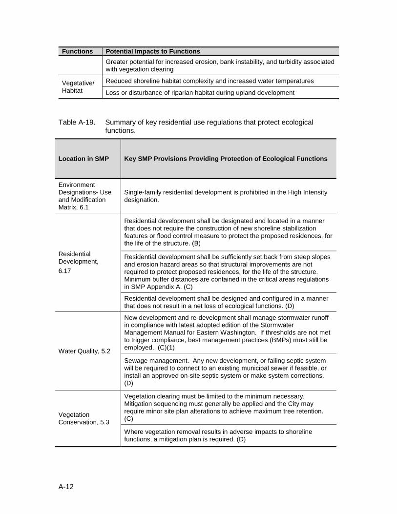
A-12
Functions Potential Impacts to Functions Greater potential for increased erosion, bank instability, and turbidity associated with vegetation clearing
Vegetative/ Habitat
Reduced shoreline habitat complexity and increased water temperatures
Loss or disturbance of riparian habitat during upland development
Table A-19. Summary of key residential use regulations that protect ecological functions.
Location in SMP Key SMP Provisions Providing Protection of Ecological Functions
Environment Designations- Use and Modification Matrix, 6.1
Single-family residential development is prohibited in the High Intensity designation.
Residential Development, 6.17
Residential development shall be designated and located in a manner that does not require the construction of new shoreline stabilization features or flood control measure to protect the proposed residences, for the life of the structure. (B)
Residential development shall be sufficiently set back from steep slopes and erosion hazard areas so that structural improvements are not required to protect proposed residences, for the life of the structure. Minimum buffer distances are contained in the critical areas regulations in SMP Appendix A. (C)
Residential development shall be designed and configured in a manner that does not result in a net loss of ecological functions. (D)
Water Quality, 5.2
New development and re-development shall manage stormwater runoff in compliance with latest adopted edition of the Stormwater Management Manual for Eastern Washington. If thresholds are not met to trigger compliance, best management practices (BMPs) must still be employed. (C)(1)
Sewage management. Any new development, or failing septic system will be required to connect to an existing municipal sewer if feasible, or install an approved on-site septic system or make system corrections. (D)
Vegetation Conservation, 5.3
Vegetation clearing must be limited to the minimum necessary. Mitigation sequencing must generally be applied and the City may require minor site plan alterations to achieve maximum tree retention. (C)
Where vegetation removal results in adverse impacts to shoreline functions, a mitigation plan is required. (D)

The Watershed Company and BERK November 2015
A-13
A-14 Shoreline Stabilization New shoreline stabilization has the potential to significantly impact hydrologic and sediment processes, and nearshore habitat (Table A-20). Standards relating to shoreline stabilization are designed to ensure that development first avoid the need for stabilization, and where stabilization is necessary, that potential impacts are minimized and mitigated (Table A-21).
Table A-20. Summary of potential impacts from shoreline stabilization.
Functions Potential Impacts to Functions
Hydrologic Increase in flow energy at the shoreline resulting in increased bank erosion downstream.
Disruption of shoreline wetlands.
Water Quality Water quality impacts associated with construction.
Removal of shoreline vegetation increases erosion and water temperatures.
Vegetative/ Habitat
Simplification of shoreline habitat complexity.
Table A-21. Summary of key shoreline stabilization regulations that protect ecological functions.
Location in SMP Key SMP Provisions Providing Protection of Ecological Functions
Shoreline Stabilization 6.19
New development must be located and designed to avoid the need for future shoreline stabilization, if feasible. This includes subdivisions and development adjacent to steep slopes. (A)
New development that would require shoreline stabilization that would cause significant impacts to adjacent or down-current properties and shoreline areas is prohibited. (B)
Soft approaches shall be used unless demonstrated not to be sufficient to protect primary structures, dwellings, and businesses. (C)
All proposals for shoreline stabilization structures, both individually and cumulatively, must not result in a net loss of ecological functions, and must be the minimum size necessary. (D)

A-14
A-15 Transportation Tables A-22 and A-23 summarize the potential impacts and the SMP provisions relating directly to transportation development. Standards for shoreline uses and modifications elsewhere in the proposed SMP also apply to transportation development, including shoreline stabilization, stormwater, and vegetation conservation, among others.
Table A-22. Summary of potential impacts from transportation facilities.
Functions Potential Impacts to Functions
Hydrologic Increase in stormwater runoff and discharge in association with more impervious surfaces
Potential for crossings to limit passage of flood flows.
Water Quality
Increase in contaminants associated with the creation of new impervious surfaces (e.g. metals, petroleum hydrocarbons)
Vegetative/ Habitat
Greater potential for increased erosion, bank instability, and turbidity associated with vegetation clearing
Fish passage impacts associated with stream crossings.
Table A-23. Summary of key transportation facility regulations that protect ecological functions.
Location in SMP SMP Provision Providing Protection of Ecological Functions
Transportation and Circulation, 6.21
When it is necessary to locate transportation infrastructure within shoreline jurisdiction, such facilities should be designed to minimize the amount of land area consumed and located as far landward from the shoreline as possible. (A)
Design, location, and construction of road and railroad facilities should minimize erosion and maintain slope stability, permit the natural movement of water, prevent the entry of pollutants or waste materials into the water body and use existing topography and preserve natural conditions to the greatest practical extent. (B.1-4)
To the greatest extent feasible, accessory parking shall be located landward of the building or use it serves. (G)
Transportation facilities shall be constructed of materials which will not adversely affect water quality or aquatic plants and animals over the long-term. (D)
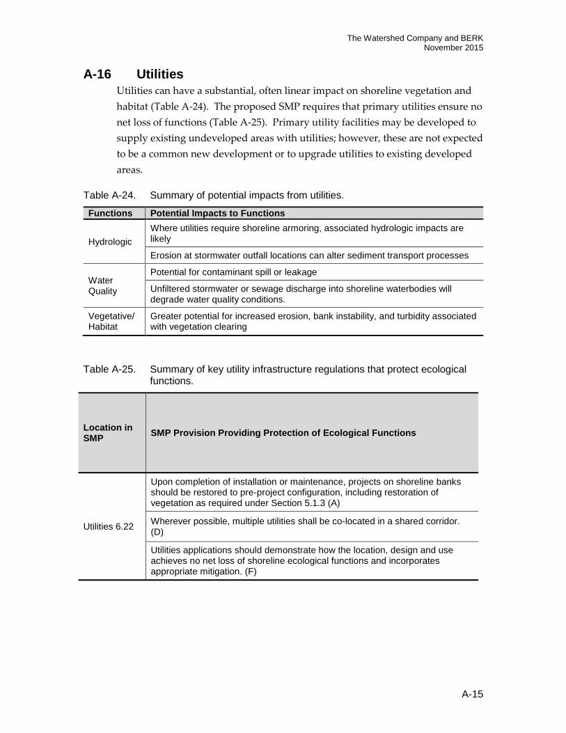
The Watershed Company and BERK November 2015
A-15
A-16 Utilities Utilities can have a substantial, often linear impact on shoreline vegetation and habitat (Table A-24). The proposed SMP requires that primary utilities ensure no net loss of functions (Table A-25). Primary utility facilities may be developed to supply existing undeveloped areas with utilities; however, these are not expected to be a common new development or to upgrade utilities to existing developed areas.
Table A-24. Summary of potential impacts from utilities.
Functions Potential Impacts to Functions
Hydrologic Where utilities require shoreline armoring, associated hydrologic impacts are likely
Erosion at stormwater outfall locations can alter sediment transport processes
Water Quality
Potential for contaminant spill or leakage
Unfiltered stormwater or sewage discharge into shoreline waterbodies will degrade water quality conditions.
Vegetative/ Habitat
Greater potential for increased erosion, bank instability, and turbidity associated with vegetation clearing
Table A-25. Summary of key utility infrastructure regulations that protect ecological functions.
Location in SMP SMP Provision Providing Protection of Ecological Functions
Utilities 6.22
Upon completion of installation or maintenance, projects on shoreline banks should be restored to pre-project configuration, including restoration of vegetation as required under Section 5.1.3 (A)
Wherever possible, multiple utilities shall be co-located in a shared corridor. (D)
Utilities applications should demonstrate how the location, design and use achieves no net loss of shoreline ecological functions and incorporates appropriate mitigation. (F)