caby i r w m p r i g - department of water resources · of fish and game, long-term stream...
TRANSCRIPT

CABY MERCURY aND SeDIMENT ABATEMENT INITIATIVE
CABY Integrated Regional Water Management Plan
Proposition 84, Round 2 Implementation Grant
6

GENERAL INFORMATION
Project Title CABY Mercury and Sediment Abatement Initiative
Abstract
An estimated 26 million pounds of mercury were used in the Sierra Nevada during the California Gold Rush. Of these, an estimated 10 million pounds were lost to the environment in placer or hydraulic mining operations and another 3 million pounds were lost from hard rock mining. The CABY region in particular was the scene of the most intensive mining and most extensive mercury pollution in California. The seven distinct projects included in this Proposal (five remediation projects, one data collection project, and one coordination project) will implement an integrated approach to address the legacy of abandoned mines in the watershed of the CABY region, and provide an example for other west-slope Sierra IRWMPs that are facing similar issues.
Organization The Sierra Fund
Partner Organizations Tahoe National Forest, South Yuba River Citizens League, Yuba Watershed Institute, Bureau of Land Management, Nevada Irrigation District, Sierra Native Alliance
Disadvantaged Community N/A
Grant Funds Requested $1,498,524.00
Non-State Match $730,180.00 (48%)
Total Budget $2,525,704.00
Watershed Yuba River, Bear River
County Nevada and Placer County
Status of Project Design
Relief Hill Hydraulic Mine Remediation – 90% Pre-final Design
Malakoff Diggins Hydraulic Mine Feasibility Study – 30% Concept Design
Omega Diggins and Scotchman Creek Hydraulic Mine Assessment – 10% Design
CABY Headwaters Resilience and Adaptability Program - March 2013 Attachment 3 - CABY Mercury and Sediment Abatement Initiative
Page 1
Attachment 3 - Work Plan
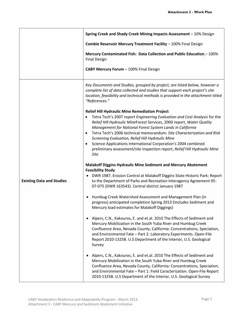
Spring Creek and Shady Creek Mining Impacts Assessment – 10% Design
Combie Reservoir Mercury Treatment Facility – 100% Final Design
Mercury Contaminated Fish: Data Collection and Public Education – 100% Final Design
CABY Mercury Forum – 100% Final Design
Existing Data and Studies
Key Documents and Studies, grouped by project, are listed below, however a complete list of data collected and studies that support each project’s site location, feasibility and technical methods is provided in the attachment titled “References.” Relief Hill Hydraulic Mine Remediation Project
Tetra Tech’s 2007 report Engineering Evaluation and Cost Analysis for the Relief Hill Hydraulic MineForest Services, 2000 report, Water Quality Management for National Forest System Lands in California
Tetra Tech’s 2006 technical memorandum: Site Characterization and Risk Screening Evaluation, Relief Hill Hydraulic Mine
Science Applications International Corporation’s 2004 combined preliminary assessment/site inspection report, Relief Hill Hydraulic Mine Site
Malakoff Diggins Hydraulic Mine Sediment and Mercury Abatement Feasibility Study
DWR 1987. Erosion Control at Malakoff Diggins State Historic Park; Report to the Department of Parks and Recreation Interagency Agreement 05-07-075 (DWR 163543). Central district January 1987
Humbug Creek Watershed Assessment and Management Plan (in progress) anticipated completion Spring 2013 (Includes Sediment and Mercury load estimates for Malakoff Diggings)
Alpers, C.N., Kakouros, E. and et.al. 2010 The Effects of Sediment and Mercury Mobilization in the South Yuba River and Humbug Creek Confluence Area, Nevada County, California: Concentrations, Speciation, and Environmental Fate – Part 2: Laboratory Experiments. Open-File Report 2010-1325B. U.S Department of the Interior, U.S. Geological Survey
Alpers, C.N., Kakouros, E. and et.al. 2010 The Effects of Sediment and Mercury Mobilization in the South Yuba River and Humbug Creek Confluence Area, Nevada County, California: Concentrations, Speciation, and Environmental Fate – Part 1: Field Caracterization. Open-File Report 2010-1325B. U.S Department of the Interior, U.S. Geological Survey
CABY Headwaters Resilience and Adaptability Program - March 2013 Attachment 3 - CABY Mercury and Sediment Abatement Initiative
Page 2
Attachment 3 - Work Plan

Data collected as part of the assessment, available but not attached Omega Diggins Hydraulic Mine and Scotchman Creek Assessment
Quality Assurance Project Plan approved by the State Water Resources Control Board
South Yuba River Citizens League 21st Century Assessment of the Yuba River Watershed
Ten years of monthly water monitoring data including dissolved oxygen, pH, conductivity and turbidity
Spring Creek and Shady Creek Mining Impact Assessment
Yuba Watershed Institute’s 1995 Inimim Forest Management Plan
Yuba Watershed Institute’s 1997 Inimim Forest Management Implementation Plan
USDA Forest Service’s General Technical Report (GTR) 220 and 237
Bureau of Land Management’s 1988 amended Management Framework Plan (MFP) for the Sierra Planning Area
Data from monthly water quality monitoring at the site including dissolved oxygen, pH, conductivity and turbidity
Combie Reservoir Mercury Treatment Facility
Integrated Regional Watershed Management Plan for the Cosumnes, American, Bear and Yuba Watersheds, 2007
Wood and others 2010 staff report, Amendments to the Water Quality Control Plan for the Sacramento River and San Joaquin River Basins for the Control of Methylmercury and Total Mercury in the Sacramento-San Joaquin Delta Estuary
South Yuba River Citizens League 21st Century Assessment of the Yuba River Watershed
Nevada Irrigation District Combie Reservoir Shoreline Management Plan
Bear River Watershed Management Plan (2003) Mercury-Contaminated Fish: Data Collection and Public Education
The Sierra Fund’s 2009 Gold Country Angler Survey Protocol
The Sierra Fund’s 2010 Gold Country Angler Survey report
Cal/EPA Office of Environmental Health Hazard Assessment (OEHHA) 2003 Health Advisory for Selected Water Bodies and updated in 2009
OEHHA’s 2008 Development of Fish Contaminant Goals and Advisory Tissue Levels for Common Contaminants in California Sport Fish (which included Methylmercury)
CALFED’s 2007annual report, Years 1 and 2: Sport Fish Sampling and Analysis
California Department of Public Health (CDPH)’s 2005 report Delta-San Joaquin River Pilot Angler Survey
California Environmental Protection Agency (Cal/EPA)’s 2003 report,
CABY Headwaters Resilience and Adaptability Program - March 2013 Attachment 3 - CABY Mercury and Sediment Abatement Initiative
Page 3
Attachment 3 - Work Plan

Evaluation of Potential Health Effects of Eating Fish from Selected Water ways in the Northern Sierra and Guidelines for Fish Consumption
Fish Mercury Project’s 2006 report of Fishing Activities in the North Delta and Sacramento River Watershed
USGS (J.T May., R.L. Hothem, C.N. Alpers, and M.A. Law) 1999 Open-File report Mercury Bioaccumulation in Fish in a Region Affected by Historic Gold Mining: The South Yuba River, Deer Creek and Bear River Watersheds
F. Shilling, A. White, L. Lippert, and M. Lubell’s 2010 peer reviewed paper Contaminated fish consumption in California’s Central Valley
State Water Resources Control Board’s 2007 Development of Methylmercury Objectives
CABY Mercury Forum
Delta Tributaries Mercury Council’s (DTMC’s) 2002 Strategic Plan for the Reduction of Mercury-related Risk in the Sacramento River Watershed
State Water Resources Control Board’s 2012 Statewide Mercury Policy and Mercury Control Program for Reservoirs informational materials, CEQA scoping documents, and web resources
The Sierra Fund’s 2008 report Mining’s Toxic Legacy: An Initiative to Assess and Address Mining Toxins in the Sierra Nevada
Status of CEQA, NEPA, and other environmental laws
Relief Hill Hydraulic Mine Remediation Project: Environmental permitting requirements have been completed by the Forest Service under CERCLA, therefore CEQA and NEPA are not required.
Malakoff Diggins Hydraulic Mine Feasibility Study: Environmental permitting (CEQA, NEPA) is not required for certain of the following activities (workplan subtasks 2.1-2.6), because they constitute the planning and design phase of the project. Workplan subtasks 2.7 and 2.8 will undergo CEQA review after the pilot/prototype phase of the project is completed and the management activity can be described in full, at the completion of this project.
Omega Diggins Hydraulic Mine Assessment: N/A – planning project
Spring Creek and Shady Creek and Spring Creek Mining Impact Assessment: N/A – planning project
Combie Reservoir Mercury Treatment Facility: DWR CEQA, Mitigated Negative Declaration, Notice of Determination 9-25-2009, has been completed for the Combie Project. The initial project analysis and CEQA clearance were completed with the assistance of a 2008 Sierra Nevada Conservancy grant in the amount of $100,000 and with NID Watershed Reserve funds. The process to acquire the permits listed below began in November 2009 and all permits have been obtained: California Department of Fish and Game, Long-term Stream Alteration Agreement for reservoir maintenance, submitted November 4, 2010 ; California Regional Water
CABY Headwaters Resilience and Adaptability Program - March 2013 Attachment 3 - CABY Mercury and Sediment Abatement Initiative
Page 4
Attachment 3 - Work Plan

Quality Control Board, Central Valley Region, Waste Discharge Requirements under Section 402 National Pollution Discharge Elimination System Permit, and Water Quality Certification under Section 401 of the Clean Water Act, submitted October 28, 2010 : U.S. Army Corps of Engineers, Nationwide Permit 16 (SPK #2009-00913), Return Water from Upland Contained Disposal Areas, received February 10, 2011.
Mercury Contaminated Fish: Data Collection and Public Education: N/A – data collection project
CABY Mercury Forum: N/A – coordination project
Work that will be completed prior to October, 2013 (assumed contract date)
Relief Hill Hydraulic Mine Remediation Project Since May 1999, the US Forest Service has pursued all the necessary steps under CERCLA to assess, evaluate, design and permit remediation activities at the Relief Hill Hydraulic Mine site in the Tahoe National Forest. Completed documents/activities include: Site Discovery and Site Characterization, Preliminary Assessment Site Inspection, Potential Responsible Party Search, and Engineering Evaluation and Cost Estimate. Environmental compliance for the site has been completed under CERCLA. Malakoff Diggins Hydraulic Mine Feasibility Study Since September 2009, The Sierra Fund has worked with State Parks, CSU Chico and other partners to complete a comprehensive assessment of the impacts of the Malakoff Diggins Hydraulic Mine on the Humbug Creek watershed, a process that will culminate in the release of a Humbug Creek Watershed Assessment document in Spring 2013. This process included establishment of a technical advisory group (“Working Group”) for the project which includes agencies and organizations involved in project implementation, regulation, research or with other interests in the project site. As part of the assessment, continuous water quality and flow monitoring equipment was installed to monitor current conditions and the impact of subsequent activities at the site. The assessment process compiled and integrated earlier studies at the site including: academic research completed at the site, archaeological and cultural investigations, and an extensive study on sediment impacts from the site conducted by the Nevada County Resource Conservation District in the 1970s and 80s. The Nevada County Resource Conservation District (NCRCD) study found that as much as 3,000lbs/min were being discharged from Hiller Tunnel during storm events (DWR, 1987). The goal of the 2011-2013 SNC-funded assessment is to quantify the sediment and mercury load from Malakoff Diggins. In order to do this, continuous monitoring equipment was installed for stage and turbidity and grab samples for TSS and mercury were collected. As a result of this water quality monitoring effort sediment and mercury loads can be quantified and used to design sediment and mercury abatement controls on the site.
CABY Headwaters Resilience and Adaptability Program - March 2013 Attachment 3 - CABY Mercury and Sediment Abatement Initiative
Page 5
Attachment 3 - Work Plan

Tours of the project activities at Malakoff Diggins to foster effective Working Group participation and regulatory involvement included: 1) the April 27, 2012 “Two directors Tour” of then-Director of California State Parks (Ruth Colman) and DTSC Director (Deborah Rafael) and 2) the June 22, 2012 tour for EPA Region 9 Administrator Jared Blumenfeld and his staff. These tours and conference related events (with the National Association of Abandoned Mines Oct 2010 tour, and Reclaiming the Sierra May 2011 tour) have greatly increased the Working Group members’ activity and familiarity with the project. The Tours also heightened the project’s visibility, not just as a scientific and engineering exercise but also as a project that has important policy implications around sediment and mercury mitigation at historic mine sites on public lands. Omega Diggins Hydraulic Mine Assessment SYRCL has conducted and collected monthly water quality monitoring and storm water monitoring at Scotchman Creek, which includes both the Alpha and Omega Diggins Mine sites, for the last ten years. US Forest Service completed a remediation and sediment and mercury control project at the Alpha Diggins mine site in 2008. SYRCL has built relationships with property owners in the watershed, and conducted informational field trips to the site, and begun organizing a “Watershed Guild” for the area. In 2009-10, SYRCL completed a preliminary watershed assessment including interviews with residents and preliminary data collection. SYRCL maintains a water quality monitoring station in Scotchman Creek but has not previously had resources to specifically assess suspended sediment and mercury concentrations from Scotchman Creek. SYRCL has defined Project Objectives for the assessment of Omega Diggins and will develop an action plan for the site as a part of this project. Spring and Shady Creek Mining Impacts Assessment In 1995, a six-year public planning process culminated in a Management Plan document for the Inimim Forest. This document, was the result of over 3000 hours of volunteer work and input from residents (including biologists, ecologists, loggers, and foresters), and government agencies, with primary partners being the Yuba Watershed Institute (YWI), Timber Framer’s Guild of North America and Bureau of Land Management. In May 1997, an Implementation Plan for the Inimim Forest was completed. The implementation plan includes detailed assessment and ongoing monitoring of stream and watershed conditions, and mapping of vegetation and old-growth forest distribution, however monitoring of mercury and sediment discharge has never been conducted for the mine scared lands in the Forest. Monthly monitoring of physical parameters on Spring and Shady Creeks began in November 2012. The recent activity of mining claims on this property and the proposed reopening of the San Juan Ridge Mine has led to the need for continuous monitoring equipment so that, similar to Humbug Creek, existing sediment and mercury loads can be quantified and in this case
CABY Headwaters Resilience and Adaptability Program - March 2013 Attachment 3 - CABY Mercury and Sediment Abatement Initiative
Page 6
Attachment 3 - Work Plan

used to inform proposed land use activities in the headwaters of these streams that drain into the South Yuba River. Project partners are committed and the project objectives have been articulated. Combie Reservoir Mercury Treatment Facility NID began the conceptual design of the Combie Reservoir Sediment and Mercury Abatement Project in 2007 as a part of a CABY-led project integration process. Though not yet funded, the project has been an integral part of the CABY plan since its inception. NID developed the project from a scientific and engineering design phase with weekly meetings with environmental consultants that specialize in mercury fate and transport issues. This early collaboration with mercury scientists allowed project engineers to design a process to address mercury contamination in sediment from a state of the art understanding of mercury’s multiple forms and developing regulatory guidelines. In fact, this project has helped advance the scientific community’s understanding of mercury monitoring principles and grain size relationships to mercury transport (NID, 2012). NID received a Sierra Nevada Conservancy grant to complete all of the environmental permitting associated with this project. CEQA, Mitigated Negative Declaration, Notice of Determination 9-25-2009, has been completed for this project (NID, 2009). Nevada Irrigation District is the Lead CEQA Agency. Additional environmental permitting that has been completed includes:
California Department of Fish and Game, Long-term Stream Alteration Agreement for reservoir maintenance, submitted November 4, 2010
California Regional Water Quality Control Board, Central Valley Region, Waste Discharge Requirements under Section 402 National Pollution Discharge Elimination System Permit, and Water Quality Certification under Section 401 of the Clean Water Act, submitted October 28, 2010
U.S. Army Corps of Engineers, Nationwide Permit 16 (SPK #2009-00913), Return Water from Upland Contained Disposal Areas, received February 10, 2011. Note: The Army Corps of Engineers has determined that the project qualifies for a Nationwide 16 Permit, subject to satisfying Water Quality Certification under Section 401 of the Clean Water Act and pre-construction authorization requirements that will be fulfilled when pre-construction activities begin.
Placer County Environmental Health Department, Hazardous Materials Business Plan
Clean Water Act 401 Technically Conditioned Water Quality Certification; Nevada Irrigation District, Combie Reservoir Sediment and Mercury Removal Project (WDID#5A29CR00068), Nevada and Placer Counties
Mercury-Contaminated Fish: Data Collection and Public Education In 2009-2010 The Sierra Fund designed and implemented an Angler Survey at 13 water bodies in the CABY region. Through this effort, The Sierra Fund
CABY Headwaters Resilience and Adaptability Program - March 2013 Attachment 3 - CABY Mercury and Sediment Abatement Initiative
Page 7
Attachment 3 - Work Plan

collected information about fish consumption and mercury awareness from over 150 people fishing at region streams, rivers, lakes and reservoirs. The questionnaire, training materials and data analysis and reporting forms used in the 2009-2010 effort are readily available for re-use at more locations, and in fact were administered by Friend of the North Fork American River to collect an additional 60 completed surveys (data from these surveys are now being analyzed). Education materials specifically designed for the Sierra Nevada’s mercury-contaminated water bodies were developed and may be used in this effort. Additionally, the 2009-2010 effort identified water bodies lacking adequate posting of fish consumption warnings, so provides a basis for implementing posting immediately. The Sierra Fund has now built a partnership with the Native Youth Conservation Corps, which has committed to taking on additional survey and public education efforts over the next three years. The survey development is complete, the quality control and assurance protocol was developed through training and survey checking, and data entry forms are complete. Although some data on fish mercury levels in CABY water bodies have been collected through various efforts, the sample size rarely meets the requirements needed to issue a fish consumption advisory. Sixteen fish tissue samples are needed for each species according to OEHHA guidelines (OEHHA, 2009). Existing fish tissue data for CABY water bodies includes (May et al. 1999) :
Combie Reservoir: 12 fish tissue samples, 10 largemouth bass and 2 bluegill catfish
Rollins Reservoir: 3 bluegill, 4 brown trout, 13 channel catfish, 1 crappie, 7 largemouth bass, and 1 small mouth bass
Bear River: 8 brown trout, and 7 rainbow trout
Englebright Reservoir: 2 largemouth bass, 14 smallmouth bass, 3 spotted bass, and 1 rainbow trout
Folsom Lake: 3 largemouth bass
Lake Natoma: 1 largemouth bass
Lake Wildwood: 11 largemouth bass
Scotts Flat: 2 bluegill, 2 brown trout, 7 largemouth bass, 1 sun fish
Deer Creek: 12 brown trout, 1 rainbow trout
South Yuba River: 6 brown trout, 8 rainbow trout CABY Mercury Forum Since 2007, CABY has been the most active IRWMP in the state to consider legacy mercury contamination, and has built a core group of agencies and organizations interested in addressing this issue. The Sierra Fund has built a committed group of advisors and an excellent statewide network of contacts focused on the impacts of abandoned mines, including agencies and organizations such as EPA Region 9, State Water Resources Control Board, Central Valley Regional Water Quality Control Board, Department of Conservation, Department of Toxic Substances Control, US Geological Survey,
CABY Headwaters Resilience and Adaptability Program - March 2013 Attachment 3 - CABY Mercury and Sediment Abatement Initiative
Page 8
Attachment 3 - Work Plan

Department of Public Health, Planning and Conservation League, Sierra Nevada Alliance, and Sierra native tribes. Existing participants in these two groups, and especially partners conducting projects within the CABY Mercury Initiative, provide a formidable roster for the CABY Mercury Forum participants, and the connections the Forum will need to leverage the results of the CABY Mercury Initiative at the state level to inform developing regulatory issues.
Procedures for coordination with partner agencies and organizations
The CABY Mercury Forum is the element of the CABY Mercury Initiative suite that was designed to promote coordination among partner agencies and organizations. Through the Forum, representatives of the CABY Mercury Initiative component projects will meet quarterly to discuss project progress, synergies, and to provide linkage to statewide and inter-IRWMP planning and regulation processes, most importantly the statewide Mercury Policy.
Description of synergies or linkages between other CABY IRWMP projects
Addressing issues of system capacity and operational efficiencies and capacity is a theme common to many of the projects within the CABY suite of projects. By retrieving elemental mercury from polluted sites with a focus on sediments behind impoundments, this project complements and supports the overall conservation, climate change adaptive management and restoration objectives of the overall Proposal. This project also supports the following CABY linkages and synergies objectives, articulated in the Introduction to the Proposal: selection of projects at multiple elevations: developing a mix of localized projects that address clear single-location needs with projects that have a regional impact; inclusion of pilot, demonstration or model projects whose benefits can then be expanded through implementation of similar projects across the region; siting of projects across all of the primary CABY watersheds; including projects that directly address the resiliency of natural and infrastructure systems; inclusion of projects which result in direct water conservation and/or use efficiencies; creation of implementation actions/projects that represent adaptive management options in response to climate change; pairing projects that create synergies of impact internally and between projects; balancing infrastructure and natural resource projects within each implementation package; and creating a balance of project sponsors across all stakeholder groups, including DAC, governmental agencies and non-profit organizations. The project will also collaborate with three other CABY projects in this proposal to train and employ Native Youth from the Native Youth Conservation Corps. The CABY Mercury Forum is the keystone project in the Mercury Initiative suite to strengthen the above-described synergies among the component Initiative projects, and provide linkage to statewide and inter-IRWMP planning and regulation processes, most importantly the Statewide Mercury Policy.
CABY Headwaters Resilience and Adaptability Program - March 2013 Attachment 3 - CABY Mercury and Sediment Abatement Initiative
Page 9
Attachment 3 - Work Plan

Status of acquisition of land or rights of way if applicable
Relief Hill Hydraulic Mine Remediation Project: Since the Forest Service is administering this project on their own lands, there are no land acquisition or access issues associated with the project.
Malakoff Diggins Hydraulic Mine Feasibility Study: The Sierra Fund has an existing access and sampling permit on file with State Parks to conduct assessment activities (see Workplan Task 2.1). This is Permit #2012-10, which is effective until September 30, 2013. The permit will be renewed or extended when it expires to cover the timeframe and activities of this project (Workplan Task 2.10).
Omega Diggins Hydraulic Mine Assessment: SYRCL can complete proposed project activities on public lands in the watershed, under an existing understanding with the Forest Service.
Shady Creek and Spring Creek Mining Impact Assessment: YWI has an existing agreement with BLM (the landowner) to conduct project activities.
Combie Reservoir Mercury Treatment Facility: NID owns the land where the project will be implemented, and additional landowner permission is not required.
Mercury Contaminated Fish: Data Collection and Public Education: All work will take place on public rights of way.
CABY Mercury Forum: N/A
If project is part of a multi-phased project, describe how the project can operate as a stand-alone project
All of the seven component projects of the CABY Mercury and Sediment Abatement Initiative can function as stand-alone projects, however they also benefit greatly by integration and subsequent phases:
Relief Hill Hydraulic Mine Remediation Project is a stand-alone project. The US Forest Service will complete all planned implementation of cleanup activities at the site. Subsequent phases consist only of ongoing operation and maintenance.
Malakoff Diggins Hydraulic Mine Feasibility Study is a phased project. The Sierra Fund will complete the engineering and design phase of the project, and evaluate treatment options to allow partners to choose viable implementation measures. The subsequent, final phase will take place after this project is complete and will consist of implementation of the chosen treatment options.
Omega Diggins Hydraulic Mine Assessment is a phased project. Under this phase of the project, the South Yuba River Citizens League will establish baseline data about suspended sediment and mercury concentrations in the Scotchman Creek watershed, which are needed to inform any subsequent
CABY Headwaters Resilience and Adaptability Program - March 2013 Attachment 3 - CABY Mercury and Sediment Abatement Initiative
Page 10
Attachment 3 - Work Plan

action in the watershed. Subsequent phases will include environmental permitting and construction of treatment options, which will take place after this project.
Spring Creek and Shady Creek Mining Impact Assessment is a stand-alone project that will result in the installation of two water quality monitoring gage stations that will collect stage and turbidity data continuously. The continuous monitoring will be correlated to periodic discharge measurements, and grab sample results for TSS and mercury so that sediment and mercury loads can be calculated for these tributaries and inform land use practices. These data will be incorporated into other existing projects to address the impacts of the San Juan Mine, and will be used to measure the impacts of new mining activities and proposed landuse and remediation actions for the headwaters as a part of future projects not yet developed.
Combie Reservoir Mercury Treatment Facility is a stand-alone project within a phased project. The Nevada Irrigation District will lease (with an option to buy) a mercury treatment facility with the DWR funds and matching NID funds, that will be one critical component of the Nevada Irrigation District’s larger Combie Reservoir Mercury and Sediment Removal project. The larger Combie Project is in total a $9 million project, and includes $2 million of USGS studies to determine the project’s overall physical benefits. While the overall Combie Project is not yet fully funded, the DWR funds request will allow for purchase (lease to own) and on-site demonstrations of the mercury removal facility – therefore the mercury removal facility is the heart of a larger Combie Project, and for the purposes of demonstration it has the ability to stand alone. With DWR funds, NID will use the mercury treatment facility to demonstrate the larger project’s potential success to additional funders and other water agencies. NID and CABY will actively pursue additional funding sources for full implementation.
Mercury-Contaminated Fish: Data Collection and Public Education is a stand-alone project. The Sierra Fund will collect crucial data necessary to gage human health impacts from mercury in the CABY region. The Sierra Fund will work to have these data incorporated into state- and region-wide planning for mercury cleanup. No further phases are foreseen, however the project results may point to recommended changes in public education materials or strategies.
CABY Mercury Forum is a stand-alone project that depends on funding of the other projects within this proposal. The CABY Mercury Forum will serve a critical integrating role in the CABY Mercury Initiative as a place where project partners will share information with each other and with other state-wide efforts.
CABY Headwaters Resilience and Adaptability Program - March 2013 Attachment 3 - CABY Mercury and Sediment Abatement Initiative
Page 11
Attachment 3 - Work Plan

SPECIFIC GOALS AND OBJECTIVES OF THE PROJECT
CABY Goals and Primary Issues Measurable Objectives
Ensure sufficient water quality to support healthy ecosystems, and dependent organisms (both human health and wildlife): Contamination, Legacy Mining Toxins, Abandoned Mine Run-Off
3 abandoned mine sites selected for remediation (planning, design, and/or implementation) as part of a collaborative process involving land owners and other stakeholders
1,300 pounds of mercury, a legacy mining contaminant, removed from water system
13,000 pounds of sediment discharge reduced from water system
3 water bodies that can achieve water quality objectives for suspended sediment and mercury in discharge
4 projects completed that identify the major threats to watersheds that are critical for surface drinking water by working with stakeholders
3 projects developed that make the forests in these watersheds more resilient to the identified threats, working with stakeholders
Ensure adequate and reliable water supply that can be adapted to climate change and can meet the needs of the region: Water Storage
Demonstrate reservoir maintenance activities at one reservoir that restore water storage capacity and that are effective at treating mercury-contaminated sediment
Anticipate climate change needs and be prepared to respond adaptively to human and ecosystem needs
2 adaptive strategies demonstrated that reservoir maintenance and abandoned mine lands restoration that will make the CABY region more resilient
Maintain and enhance functioning landscapes that provide sustainable services for humans: Native Americans
2 projects that involve substantial Native American contribution in project development and implementation
Ensure sustainable employment in the CABY region, including disadvantaged communities by creating 66 new jobs (various FTE) and sustaining 23 professional jobs
Education and Outreach will be considered as a possible component for every project that CABY identifies for implementation
Complete data set for fish tissue data at 8 priority water bodies in CABY region
Post signage about existing fish consumption guidelines at 12 303(d) listed water bodies in the CABY region
CABY Headwaters Resilience and Adaptability Program - March 2013 Attachment 3 - CABY Mercury and Sediment Abatement Initiative
Page 12
Attachment 3 - Work Plan

Quantify number and type of people consuming fish from CABY water bodies contaminated with mercury (303 (d) listed) by conducting 150 surveys of individuals fishing at each location
Educate 200 individuals fishing at CABY water bodies about the presence and dangers of eating mercury-contaminated fish
Overarching Objective: Share useable data and information across the region
Regular data updates to CABY website and state and all other relevant databases and agencies.
Stimulate region-wide coordination and planning
Develop one region-wide Mercury Strategy to encourage that all planning in the region be completed in a coordinated fashion that ensures communication and shared solutions
PURPOSE AND NEED OF THE PROJECT
The seven integrated projects that make up the CABY Mercury Initiative are designed to address the region’s oldest and longest neglected water quality impacts: mercury and sediment drainage from abandoned mines. The 19th century California Gold Rush is considered the primary source of mercury contamination to the Sacramento River and the San Francisco Bay-Delta. An estimated 26 million pounds of mercury were used in the Sierra Nevada during the California Gold Rush (Alpers, et al. 2005). Of these, an estimated 10 million pounds were lost to the environment in placer or hydraulic mining operations and another 3 million pounds were lost from hard rock mining (Churchill, 2000). The CABY region in particular was the scene of the most intensive mining and most extensive mercury pollution in California (California Department of Conservation (CDOC) 2003). Mercury from historic gold mining can still be found at dangerously high levels in Sierra Nevada waterways and fish tissue (Alpers et al. 2005a,b). Continuous and ongoing erosion of mine sites in the headwaters, with each storm event that occurs, washes mercury-contaminated sediment into downstream impoundments such as Englebright or Combie Reservoir,
Ranking of Mining-Impacted watersheds
in the Sierra Nevada Province of the
California Bay-Delta Authority Watershed
(source: CA Department of
Conservation, 2003)
CABY Headwaters Resilience and Adaptability Program - March 2013 Attachment 3 - CABY Mercury and Sediment Abatement Initiative
Page 13
Attachment 3 - Work Plan

where the sediment reduces water storage capacity while the mercury transported with it methylates and permeates the aquatic ecosystem, becoming a serious health hazard to the humans and wildlife that rely on this water body and downstream environments. Mercury is a water quality constituent of national concern. Consumption of mercury-laden fish leads to developmental delays in fetuses, infants, and children, and can lead to neurological symptoms and other health problems in adult humans as well as ecological problems in wildlife (Weiner et al. 2003a,b). Concerns about mercury pollution stem largely from the potential adverse effects of dietary exposure to methylmercury in fish, avian species, and mammals (including humans). Documented consequences of methylmercury pollution include (1) direct adverse effects on the health of fish, wildlife, and humans; (2) contamination of fishery resources that diminishes their nutritional, cultural, socioeconomic, and recreational benefits; and (3) socio-cultural damage to indigenous peoples who fish for subsistence. Mercury contamination is a pervasive issue in the Bear, American, and Yuba River watersheds (Alpers et al. 2005). More than twelve regional water bodies are 303(d) listed as impaired for mercury (CVRWQCB 2010). All studies that have been completed to determine mercury levels in fish tissue from CABY water bodies have shown levels over the EPA threshold for safe consumption (0.3ppm mercury in fish tissue) including:
Fish tested in Combie Reservoir (largemouth bass and Sacramento sucker) and in tributaries of the Yuba River were among the highest in mercury in a state-wide survey completed by the State Water Resources Control Board’s Surface Water Ambient Monitoring Program (Davis et al. 2010).
The findings from the most comprehensive survey of fish in the Yuba and Bear watersheds (May et al., 1999) found that fish tissue levels meet and exceed Cal/EPA Office of Environmental Health Hazard Assessment (OEHHA) and Food and Drug Administration levels (0.3ppm mercury in fish tissue.):
o Englebright Reservoir: all smallmouth and spotted bass that were >1 foot and >250 grams (1/2 lb) had levels >0.3 ppm;
o Scotts Flat Reservoir: most largemouth bass >1 foot and 500 grams (1 lb) had levels >0.3 ppm;
o Rollins Reservoir: most channel catfish and most largemouth bass >1 foot and >400 grams had levels >0.3 ppm;
o Combie Reservoir: all largemouth bass >1 foot and >400 grams had levels >0.7 ppm
o Camp Far West: all spotted and largemouth bass and channel catfish >1 foot and >300 grams had levels >0.5 ppm, half of the spotted bass exceeded FDA level of 1.0 ppm; and
o Bear River at Dog Bar Road and Little Deer Creek at Pioneer Park: half of brown trout sampled >10 inches and >200 grams had levels >0.3 ppm.
Placer County Water Agency (PCWA) conducted methylmercury studies between 2007 and 2010 looking at concentrations in sportfish. About 55 percent of fish exceeded the OEHHA’s guidelines for methylmercury, and over 16 percent of crayfish exceeded the standard (PCWA 2010d).
CABY Headwaters Resilience and Adaptability Program - March 2013 Attachment 3 - CABY Mercury and Sediment Abatement Initiative
Page 14
Attachment 3 - Work Plan

Data concerning mercury and methylmercury in water, sediment, and biota from sites in the Bear River watershed are available online (http://ca.water.usgs.gov/mercury/bear-yuba/) (Wiener et al. 2003).
In addition to mercury contamination, massive amounts of sediment draining from eroding hydraulic mining pits also impacts water quality and water storage in the CABY region. Today, historic hydraulic mining pits exhibit extreme badlands topography, and continues to erode massive amounts of sediment contaminated with mercury during storm events. For example, a study at Malakoff Diggins Hydraulic Mine found that as much as 3,000lbs/min of sediment were being discharged during storm events (DWR, 1987). This mercury-contaminated sediment discharged from hydraulic mines is deposited in the upstream reaches of CABY region reservoirs, where it occupies valuable water storage space. The presence of this sediment in reservoirs is a further problem because it is an environment where mercury is likely to be methylated and incorporated into the aquatic and terrestrial foodchain. It is estimated that 2.1 billion m3 of sediment have filled reservoirs across the state of California (Minear and Kondolf, 2009). Said another way, sediment is filling 1.7 million AF of water storage space in reservoirs, decreasing the reservoir capacity to half the initial capacity for about 200 reservoirs. Englebright Reservoir on the South Yuba River downstream of Malakoff Diggins, Relief Hill and Omega Diggins Hydraulic Mines (among others) has 18,750 AF of water storage space occupied by sediment (25% of its total 70,000 AF) (James, 2005). Water supply reliability will only improve if reservoirs in the CABY region are able to remove sediment that has accumulated behind them rather than constructing additional water storage facilities. Climate change’s predicted preciptation change of depleting the snow pack only makes water storage in the headwaters a more critical component to climate change adaptability. The ongoing and complex problem of mercury and sediment discharge in Sierra Nevada waterways results in a broad range of interconnected needs for the Sierra Nevada foothills, and the CABY region in particular. In summary, the needs that will be addressed by this project are:
I. Mercury and sediment discharge needs to be remediated at its source, whether at upland abandoned mine sites or where it has accumulated in reservoirs.
II. Significant data gaps on fish mercury levels and fish consumption rates need to be filled, in order to adequately protect public health.
III. Any effort to address this multifaceted issue needs to be conducted in a coordinated manner, considering the Statewide Mercury Policy objectives now under development.
I. Mercury and sediment discharge needs to be remediated at its source The transport of mercury and methylmercury through Sierra Nevada reservoirs (via spillways and controlled releases) is a significant contributor to Bay-Delta methylmercury levels. Over a 20-year period (1984-2003) it is estimated that 98% of total mercury loads to the Delta came from upstream tributaries (Wood et al. 2010a). In the CABY region in particular, mercury and methylmercury transport through Camp Far West Reservoir (in the Bear River watershed downstream of Combie Reservoir), were the the subject of a study conducted by USGS (Alpers, et al. 2008). This study found that significant amounts of mercury were being methylated in the reservoir and were being incorperated into the aquatic food chain at levels that warented a “do not eat” fish advisory for all fish in the Camp Fest West Reservoir. The tributaries of the Sacramento River are the source of 80% or more of total mercury flowing into the Bay-Delta, and “the Cache Creek, Feather River, American River, Putah Creek watersheds in the Sacramento Basin have both relatively large mercury loadings and high mercury concentrations in suspended sediment, which makes these watersheds effective candidates for total mercury load reduction programs” (Wood et al. 2010a).
CABY Headwaters Resilience and Adaptability Program - March 2013 Attachment 3 - CABY Mercury and Sediment Abatement Initiative
Page 15
Attachment 3 - Work Plan

Mercury loads entering the Delta are highest in winter and spring (Foe 2003), which is when the majority of sediment and mercury is transported from CABY watersheds downstream to the Sacramento River and Bay-Delta. Significant mercury and sediment impacts from abandoned mines reduces the CABY region’s headwaters resillience, especially in the face of climate change. Climate change poses multiple and various threats to wildlife populations. Sediment sources that are filling up CABY region reservoirs result in shallow, warm-water habitat where there was formerly a deeper, cooler habitat that provided cold water refuge. Wildlife populations that are already in environments of stress due to mercury and turbid conditions are more susceptible to the impacts of climate change. Mercury is a powerful neurotoxin that can cause decreased reproductive success, this has been shown in fish-eating birds, but the neurotoxic effects hold true for any vertebrate species. Of particular concern are animals that have a diet made up primarily of fish, such as river otters and osprey. The projects in this Iniatitive will result in improved watershed function by 1) improved habitat with less contamination from suspended sediment and mercury; and 2) improved infiltration to eth vadoze zone as opposed to surface runoff from surfaces that are devoid of soil from hydraulic mining practices. 3) Finally, sediment sources that are filling up CABY region reservoirs result in shallow, warm-water habitat where there was formerly a deeper, cooler habitat that provided cold water refuge. After seven years of working to assess and address legacy mining’s impacts on the region, CABY Mercury and Sediment Abatement Initiative partners have identified two places the drainage from abandoned mines can viably be treated, as illustrated in the draft conceptual design below:
A) Upland sources such as abandoned hydraulic mining sites where the barren badlands topography and heavy historic mercury usage contribute to massive amounts of mercury-contaminated sediment washing downstream with every rain; and
B) Reservoirs downstream from abandoned hydraulic mines where the discharged sediment accumulates, occupying water storage space and bioaccumulating in the aquatic food chain.
A.
B.
CABY Headwaters Resilience and Adaptability Program - March 2013 Attachment 3 - CABY Mercury and Sediment Abatement Initiative
Page 16
Attachment 3 - Work Plan

The five remediation projects that are components of the CABY Mercury Initiative demonstrate model approaches to sites at various stages of planning and implementation.
A. Upland Abandoned Mine Sources – without the four CABY Mercury Initiative projects described below, sediment and mercury will continue to drain unchecked and in some cases unmonitored into the South Yuba River: The Relief Hill Hydraulic Mine Remediation Project has completed all planning phases, and will
implement Best Management Practices to reduce sediment and mercury drainage from this abandoned mine into the South Yuba River watershed.
The Malakoff Diggins Hydraulic Mine Feasibility Study has undergone a three-year water quality and historical records assessment process, and will use these established baseline data to evaluate treatment options for this mine that drains into the South Yuba River just downstream of the Relief Hill drainage.
The Omega Diggins Hydraulic Mine Assessment Project has collected preliminary baseline data for the Scotchman Creek watershed, and will now utilize the assessment protocols established by the Malakoff Diggins project to conduct continuous stage and turbidity monitoring that will be used to quantify sediment and mercury loads in the highest mining-impacted tributary (Scotchman Creek) of the South Yuba River watershed in order to inform treatment options.
The Spring and Shady Creek Assessment Project will utilize the assessment protocols established by the Malakoff Diggins project to conduct continuous water quality monitoring in two tributaries of the South Yuba River watershed just downstream of the Malakoff Diggins drainage in order to detect water quality impacts from the newly proposed San Juan Ridge Mine
B. Downstream Reservoir Deposits – without the CABY Mercury Initiative project described below, mercury-
contaminated sediment will continue to reduce valuable water storage space in Combie Reservoir, where routine water storage capacity dredging has been halted because of its mobilization of mercury: The Combie Reservoir Treatment Facility will demonstrate an innovative technology to remove
mercury-contaminated sediment that is building up in reservoirs downstream of historic hydraulic mines on the Bear River, a technique that may be applied to numerous reservoirs in the mining-impacted CABY region (and other IRWM regions in the Sierra Nevada Foothills) including Englebright Reservoir on the South Yuba River.
Furthermore, mercury from gold mining in the Sierra Nevada is more biologically available than material from mercury mines in the Coast Range (Wood et al., 2010b). Therefore, the CABY Mercury and Sediment Abatement Initiative is perhaps more effective at solving the Bay-Delta methylmercury problem than a similar project in the Coast Range because it removes mercury that is likely to methylate and become biologically available in the Bay-Delta. II. Significant data gaps on fish mercury levels and fish consumption rates need to be filled Even though many CABY water bodies are known to be contaminated with mercury, fish consumption advisories are limited, due to lack of an adequate number of fish tissue samples from each water body. Table 1 (below) indicates the status of 303(d) listing according to data from the Central Valley Regional Water Quality Control Board (CVRWQCB) and the 2003 and 2009 OEHHA fish advisories.
CABY Headwaters Resilience and Adaptability Program - March 2013 Attachment 3 - CABY Mercury and Sediment Abatement Initiative
Page 17
Attachment 3 - Work Plan

Table 1: Regulatory Status of Mercury-Impacted Water Ways in the Yuba and Bear Watersheds
The California Office of Environmental Health Hazard Assessment (OEHHA) has issued fish consumption advisories for several CABY region water ways based on mercury levels in fish (OEHHA, 2009). In 2003, OEHHA issued an interim fish advisory for water bodies in the Sierra Nevada, and in 2009 OEHHA updated this advisory. In the advisory update process, the criteria for what constituted enough data for a fish advisory changed and more fish samples were required in order to issue a human health advisory (OEHHA, 2009). Because of limited fish samples from several CABY locations, safe eating guidelines were eliminated at some water bodies. The OEHHA advisories that existed in 2003 but not in 2009 reflect the need for more data rather than an improved fishery. It should be noted that regardless of the status of the OEHHA advisory, the federal advisory is in place for all water bodies that do not have local (country or state) advice. The few water bodies that have existing fish consumption advisories do not have complete advisories for the most hazardous types of fish. For example, the existing consumption advisory at Rollins Reservoir warns anglers to limit consumption of catfish (OEHHA 2009). Due to lack of fish tissue samples, there is no advisory at Rollins Reservoir for any other fish may be caught there including species of bass that likely have higher mercury levels than the catfish. However to the public, this lack of advisories may send the incorrect message that catfish is the only species of concern at Rollins Reservoir. The CABY Sediment & Mercury Abatement Initiative project Mercury Contaminated Fish: Data Collection and Public Education will address the critical lack of fish tissue data that is at the root of the lack of public information about fish contamination at CABY water bodies. The project will complete the data set for each species of
Mercury-Impacted
Water Way
303(d) Listed as impaired by mercury (CVRWQCB 2010)
Fish Consumption Advisory 2003 (OEHHA 2003)
Fish Consumption Advisory 2009 Update (OEHHA 2009)
Deer Creek X* X **
Upper Scotts Flat Lake X X **
Lower Scotts Flat Lake
Lake Wildwood X
Bear River X X **
Rollins Lake X X X
Lake Combie X X X
Camp Far West
Reservoir X X X
South Yuba River X X **
North Yuba River X
Lake Englebright X X X
Lower Yuba River
(below Englebright) X
Lower American River
(below Nimbus Dam) X X X
* 303(d) listings have been issued for Little Deer Creek, a tributary to Deer Creek.
** Removed from the fish advisory during the 2009 update due to insufficient number of
samples
CABY Headwaters Resilience and Adaptability Program - March 2013 Attachment 3 - CABY Mercury and Sediment Abatement Initiative
Page 18
Attachment 3 - Work Plan

concern at each 303(d) listed water body listed above (Table 1). Data will be collected in a manner that is consistent with state standards so that it may be incorporated into the state database that is used by OEHHA to create fish consumption advisories. Without the data collected through this project, the public continue to be unaware that they are consuming mercury-contaminated fish. Understanding how, and if, climate change plays a part in the mercury methylation process is an important consideration for CABY region stakeholders. Because temperature is a factor in the methylation process, it is anticipated that an increase in regional air temperatures and a decrease in the region’s annual snow pack will result in higher water temperatures and, therefore, higher rates of methylation of inorganic mercury. CABY has identified this as a topic for examination as the region further develops its climate change modeling and understanding of regional vulnerabilities. The fish tissue data collected as part of this project will provide an important comparison to previously collected data and future studies, in order to show whether the rate of methylation is increasing. In addition to addressing the root problem in the lack of public information about mercury, this project will work to alleviate the immediate need for more information on existing mercury contamination by individuals who are fishing. Some demographic or ethnic groups such as Native Americans and Southeast Asian immigrants who traditionally eat sport fish may be disproportionately impacted by mercury contamination of the fish. The Native Peoples of the Sierra Nevada were decimated by the Gold Rush, and the presence of mercury in fish perpetuates the cultural devastation today. Additionally, low-income people of a variety of ethnicities view fishing as an inexpensive way to feed their families, and may not be aware of the potentially serious health effects. While the California Department of Public Health (CDPH) has made efforts to educate these communities in at Delta fishing locations, signage and public information at mercury –contaminated water bodies in the CABY region is almost non-existent. In fact, there is evidence that low-income anglers from Central Valley communities may be traveling to the CABY region water bodies to fish, since there are fewer warnings posted (TSF 2011). The CABY Sediment & Mercury Abatement Initiative project Mercury Contaminated Fish: Data Collection and Public Education will include public education to anglers about fish-mercury contamination, where to learn about state-issued fish consumption advisories, and guidelines to follow if no state-issued advisory is in effect. III. Any effort to address this multifaceted issue needs to be conducted in a coordinated manner Mercury use presents a mining legacy of extensive, often toxic water quality challenges throughout the CABY region, and in many places mercury concentrations violate federal water quality limits. This project will contribute to identifying implementation measures for mecury and sediment in the upper watersheds for the Methylmercury Total Maximum Daily Load (TMDL) in the Delta and upcoming Statewide Mercury Policy and other mercury TMDLs in the upper watershed tributaries. The State Water Resources Control Board and nine Regional Water Quality Control Boards are currently in the process of developing a statewide Policy to control mercury in California’s waters. Key elements of the Policy will include:
1. A Control Program for mercury in the state’s reservoirs, and 2. New standards (objectives) for mercury in the tissues of certain species of fish.
According to the most recent public information release (July 2012), The Water Board will consider adopting the Policy in late 2013. Once adopted, reservoir operators, land managers and others will be expected to design and implement sediment and mercury control programs to comply with the Policy’s requirements and reduce their mercury contributions to the state water system.
CABY Headwaters Resilience and Adaptability Program - March 2013 Attachment 3 - CABY Mercury and Sediment Abatement Initiative
Page 19
Attachment 3 - Work Plan

The CABY Sediment and Mercury Abatement Initiative component projects contribute to the development and implementation of the two elements of the Statewide Mercury Policy as well as development of other TMDLs:
1. A Control Program for mercury in the state’s reservoirs The Combie Reservoir Treatment Facility Project will fill the need for demonstration of a viable
technology for operators of mercury-impacted reservoirs statewide to respond to the new Mercury Policy’s control program and discharge requirements for mercury in the state’s reservoirs.
The four headwaters remediation projects will fill the need for quantification and reduction of mercury sources to 303 (d) listed waterways, and downstream reservoirs – the only long term solution to reducing mercury discharge from reservoirs.
The four headwaters remediation projects will fill the need for demonstration of best practices for assessment and reduction of mercury discharge into 303 (d) listed waterways, and downstream reservoirs, which may be adopted by other land managers to meet the new Mercury Policy’s requirements.
The CABY Mercury Forum will ensure that all component projects within the CABY Sediment and Mercury Abatement Initiative proceed in a manner relevant to the development of the Statewide
State Water Resources Control Board map of 303(d) listed water bodies in California that may be addressed through the Statewide Mercury Policy (SWRCB 2012)
CABY Headwaters Resilience and Adaptability Program - March 2013 Attachment 3 - CABY Mercury and Sediment Abatement Initiative
Page 20
Attachment 3 - Work Plan

Mercury Policy, and that best practices for implementing the policy that are demonstrated by the component projects are shared with other land and water managers across the state.
The Mercury Contaminated Fish: Data Collection and Public Education project will fill the need for complete baseline data on fish mercury concentrations, so that benefits of the above described mercury discharge reductions may be measured.
2. New standards (objectives) for mercury in the tissues of certain species of fish
As part of the proposed Statewide Mercury Policy, the State Water Board is developing a set of standards (“objectives”) for safe amounts of methylmercury in the tissues of fish. These objectives will inform mercury policy, mercury pollution prevention plans, and water quality permits. They will apply to California’s inland waters, enclosed bays, and estuaries; and protect humans and wildlife that consume locally caught fish (SWRCB Website) . The new standards for mercury levels in fish tissue in the proposed Mercury Policy will be developed based on information about human fish consumption rates (SWRCB 2006). While data has been collected on fish consuption rates in the San Francisco Bay and Delta from angler surveys, little data has been collected on fish consuption rates from the Sierra Nevada foothills or the CABY region in particular. California Department of Public Health (CDPH) interviewed over 1,000 anglers in the San Francisco Bay Area in 1998-1999 (SFEI, 2001b). CDPH also completed a smaller Pilot Angler Survey in the San Joaquin River and Delta area in 2005 (CDPH, 2005). The Healthy Fish Coalition, which includes UC Davis researchers and students, performed angler surveys in 2005 through 2008 in the Sacramento River and Delta (Shilling, et al., 2010). Despite the growing interest in mercury exposure from sport fish consumption in the California Bay/Delta, comparatively little attention has been paid to the upper watershed. Only two surveys have been conducted:
A. A creel survey at Lake Englebright in 2003 and 2004: The creel survey identified the number of species and size of fish that were caught and retained but did not collect data regarding fish consumption patterns, demographics or level of health hazard awareness (Upper Yuba River Studies Program, 2006).
B. The Gold Country Angler Survey, a pilot effort conducted by The Sierra Fund in 2009-10: This effort, modeled on the CDPH efforts in the Delta, interviewed 151 anglers at CABY region water bodies known to be contaminated with mercury (TSF 2011). This survey indicated that over 90% of respondents do consume locally caught fish, some consuming mercury at levels considered unsafe according to OEHHA standards. However, with such a small sample size, this study merely points to the need for more angler surveys to be completed from CABY water bodies. 60 additional surveys were conducted in 2011-12 by Friends of the North Fork of the American River, implementing the same questionnaire and survey protocol used by The Sierra Fund in 2009-10. Data from these surveys is currently being analyzed at CSU Chico.
The CABY Sediment & Mercury Abatement Initiative project Mercury Contaminated Fish: Data Collection and Public Education will address the need for more information about fish consumption rates at regional water bodies. This project will include collection of at least 150 additional surveys, implementing the same questionnaire and survey protocol used by The Sierra Fund in 2009-10, bringing the total number of surveys collected in the region up to at least 360. These data will be critical in the development of fish tissue mercury objectives in the Statewide Mercury Policy that are relevant to the CABY region, which in turn will inform the cleanup standards required by the Policy and other mercury TMDLs.
CABY Headwaters Resilience and Adaptability Program - March 2013 Attachment 3 - CABY Mercury and Sediment Abatement Initiative
Page 21
Attachment 3 - Work Plan

DESCRIPTION OF THE PROJECT
This section includes a general description of the purpose and component projects within the CABY Mercury and Sediment Abatement Initiative, and how the projects are integrated. Additional detailed description of each component project is provided in the Project Work Tasks section, below. The purpose of the “CABY Mercury and Sediment Abatement Initiative” is to implement an integrated approach to address the legacy of abandoned mines in the watershed of the CABY region, and provide an example for other west-slope Sierra IRWMPs that are facing similar issues.
The CABY Mercury and Sediment Abatement Initiative is an integrated suite of seven distinct projects (five remediation projects, one data collection project, and one coordination project):
Relief Hill Mine Remediation Project (Tasks 5 & 7), which will halt sediment and mercury discharge at a historic hydraulic mine site in the South Yuba watershed, by implementing shovel-ready cleanup activities;
Malakoff Diggins Hydraulic Mine Feasibility Study (Task 2), which will evaluate and select alternatives to address mercury and sediment discharge from the historic hydraulic mine at Malakoff Diggins State Historic Park, in order to make the project shovel-ready for treatment implementation;
Omega Diggins Hydraulic Mine Assessment (Task 3), which will establish baseline data about suspended sediment and mercury concentrations in the Scotchman Creek watershed, in order to inform subsequent cleanup activities at the Omega Diggins Hydraulic Mine site;
Spring and Shady Creek Assessment (Task 4), which will monitor water quality on public lands that were heavily impacted by historic mining activities and inform a new proposed mining operation’s monitoring and remediation responsibilities through the permitting process;
Combie Reservoir Mercury Treatment Facility (Task 6), which will demonstrate a process for removing mercury from sediment while maintaining water storage capacity in reservoirs heavily impacted by mercury-contaminated sediment from upstream abandoned mines;
Mercury-Contaminated Fish: Data Collection and Public Education (Task 8), which will fill critical information gaps on mercury tissue levels in fish that are being consumed from CABY water bodies, and the quantity of fish being consumed, in order to allow adequate public health information to be issued.
CABY Mercury Forum (Task 9), the purpose of which is to integrate the above-listed projects within the CABY Mercury Initiative and showcase their results within the region, to other IRWMPs and to Statewide Mercury Policy development efforts.
The suite of seven projects presented as the “CABY Mercury and Sediment Abatement Initiative” is integrated around the following four topics:
Reduce sediment and mercury contamination of water bodies in the CABY region
o Four projects at potential remediation sites in the upper watersheds of the South Yuba River demonstrate best practices to design and implement measures to abate sediment and mercury runoff from historic mines (Relief Hill Hydraulic Mine Remediation, Malakoff Diggins Hydraulic Mine Feasibility Study, Omega Diggins Mine Assessment, Spring and Shady Creek Mine Impact Assessment)
o One project demonstrates an innovative technology capable of treating mercury-contaminated sediments that have accumulated in downstream reservoirs (Combie Reservoir Mercury
CABY Headwaters Resilience and Adaptability Program - March 2013 Attachment 3 - CABY Mercury and Sediment Abatement Initiative
Page 22
Attachment 3 - Work Plan

Treatment Facility)
Coordinate agencies and organizations working to reduce sediment and mercury contamination
o A coordinated approach to region-wide sediment and mercury control from legacy mining and effectiveness of successful practices in these model projects will be will be presented at the CABY Mercury Forum (CABY Mercury Forum)
Increase data and awareness of human exposure to mercury-contaminated fish from CABY water bodies
o Fish tissue and fish consumption data will be collected, and signage of sport fish consumption guidelines and mercury health hazards, will be posted at popular fishing locations at mercury impacted water bodies (Mercury Contaminated Fish: Data Collection and Public Education)
Provide a model for other IRWMPs facing impacts of legacy mining and implementation requirements associated with the Statewide Mercury Policy
o Coordination efforts will allow the success of the CABY region projects to be showcased and leveraged at the statewide level (CABY Mercury Forum)
o Fish tissue data and fish consumption data will provide a baseline for human exposure calculations in the Statewide Mercury Policy (Mercury Contaminated Fish: Data Collection and Public Education)
o Headwaters restoration projects will provide a model for thousands of mine sites in other IRWM regions and demonstrate feasibility of Statewide Mercury Policy implementation requirements (Relief Hill Hydraulic Mine Remediation, Malakoff Diggins Hydraulic Mine Feasibility Study, Omega Diggins Mine Assessment, Spring and Shady Creek Assessment)
o Reservoir treatment project will provide a model for removing sediment that is occupying water storage space storage capacity at every other west-slope Sierra reservoir and demonstrate feasibility of Statewide Mercury Policy implementation requirements for reservoirs (Combie Reservoir Mercury Treatment Facility)
CABY Headwaters Resilience and Adaptability Program - March 2013 Attachment 3 - CABY Mercury and Sediment Abatement Initiative
Page 23
Attachment 3 - Work Plan

\
\
[i[i
[i[i
[i
¬«E
¬«D
¬«C¬«B
¬«A
Yuba River Watershed
Omega Diggins MineAlpha Diggins Mine
North San Juan Mine
Malakoff Diggins MineRelief Hill Diggins Mine
Bear River Watershed
American River Watershed
F
ROLLINS RESERVOIR
SCOTTS FLAT RESERVOIR
COMBIE RESERVOIR
South Yuba River
NorthFork American River
Bear
River
Middle Fork American River
North Fork American River
Bear
Rive r
South Yub a River
§̈¦80
£¤20
£¤49
£¤174
£¤49
£¤20
Nevada City
Grass Valley
I0 5 102.5Miles
Project 6 CABY Mercury and Sediment Abatement Initiative
$\
$\
£¤5
£¤5
£¤80S.F.
SAC.
Locator Map
Legend[i Abandoned Mine
Watershed Boundary
F. Mercury Contaminated Fish: Data and Education
Mercury and Sediment Abatement InitiativeLabel Project NameA. Omega Diggins Hydraulic Mine AssessmentB. Relief Hill Hydraulic Mine RemediationC. Spring Creek and Shady Creek Mining Impacts AssessmentD. Malakoff Diggins Hydraulic Mine Feasibility StudyE. Combie Reservoir Mercury Treatment FacilityF. Mercury Contaminated Fish: Data and Education
Combie Mercury Treatment Facility
CABY Headwaters Resilience and Adaptability Program - March 2013 Attachment 3 - CABY Mercury and Sediment Abatement Initiative
Page 24
Attachment 3 - Work Plan

PROJECT WORK TASKS
Budget Category (A) DIRECT PROJECT ADMINISTRATION
TASK 1: DIRECT PROJECT ADMINISTRATION
Subtask 1.1: Administration and Management The Sierra Fund will take the lead in CABY Mercury Initiative fiscal management including finalizing work plans, developing and managing subcontracts, developing and disseminating project information, coordinating with the DWR grant manager, and trouble-shooting any project financial, legal or administrative issues that may arise out of project implementation. As soon as funding agreements are signed with DWR, TSF CEO and TSF Finance Director will meet individually with each agency leading a component project in the CABY Sediment and Mercury Abatement Initiative, to review grant terms and reporting requirements, and create project MOUs. Subtask 1.2: Labor Compliance
Prior to awarding any contract for public works The Sierra Fund will create and submit to Department of Water Resources (DWR) a Labor Compliance Program that meets the standards set in Labor Code Section 1771.5(b). This Labor Compliance Program will become an obligation of The Sierra Fund and any CABY Mercury Initiative sub-recipients under the terms of the grant agreement with the DWR. This Labor Compliance Program will consider all relevant labor codes and the applicability of prevailing wage laws in developing the Budget as explained in Section IV of the 2012 Guidelines.
Subtask 1.3: Reporting The Sierra Fund will establish reporting protocols to ensure consistent and timely reporting to DWR of CABY Mercury Initiative project activities and finances. Quarterly progress reports will include a narrative of accomplishments of the project as well as a summary of challenges experienced and how they were managed, performance measures, and photos, data, or other information developed as part of the project activities. Quarterly financial reports will include copies of all invoices paid, an accounting of funds used and funds remaining, and requests for any needed budget changes will be made in advance of any budget change approvals. The Sierra Fund will also submit final financial and project reports at the end of the project. Subtask 1.4: Coordination with partner agencies and organizations The Sierra Fund will establish contracts and/or MOUs with CABY Mercury Initiative project partners, which will include reporting protocols for partners to ensure consistent and timely reporting of activities and finances. As described in Subtask 1.1 above, as soon as funding agreements are signed with DWR, TSF will meet individually with each agency leading a component project in the CABY Sediment and Mercury Abatement Initiative, to ensure that they understand grant terms and reporting requirements. Throughout the grant period, The Sierra Fund will maintain active communication with partners on this collaborative project using two methods: semi-annual project partner meetings to ensure smooth coordination and allow for any needed time or activity adjustments; and regular reporting with point-
CABY Headwaters Resilience and Adaptability Program - March 2013 Attachment 3 - CABY Mercury and Sediment Abatement Initiative
Page 25
Attachment 3 - Work Plan

person at each project partner organization or agency using email to ensure that project partners are kept informed about each other’s activities, challenges and successes. Quarterly project and financial reports will be circulated to the partners in this collaborative. Additionally, a list of project partners and others interested in receiving regular information about project progress will be maintained and used for distribution of the meeting announcements and emails. Subtask 1.5: Administration and Management of Component Projects The lead organization or agency for each of the CABY Mercury Initiative component projects will take the lead in management of their respective project. Some administration and management tasks vary by project and are described in the individual project workplans below, however all projects will include common management and administration activities including:
Coordinating with partners,
Finalizing work plans and ensuring that work is completed in a timely manner,
Managing project funds,
Submitting quarterly progress reports, invoices and final reports to the CABY Mercury Initiative sponsor (The Sierra Fund) including performance measures, and
Troubleshooting any project financial, legal or administrative issues that may arise out of project implementation.
Task Task Title Deliverables
1 Direct Project Administration
1.1 Administration and Management Invoices as required
Finalized workplan and budget
Finalized subcontracts and/or MOUs with project partners
Financial and performance reporting systems established
Accessible and accurate records
1.2 Labor Compliance Adherence to Labor Code Compliance through Board policies, administrative regulations and contracting procedures and documents
Submission of Labor Compliance Program
1.3 Reporting Monthly Invoices and Reports
Quarterly, Annual and Final Reports to DWR
Reports to CABY including performance measures
Final Narrative Report and Financial Report
1.4 Coordination with partner agencies List of committed project partners and point
CABY Headwaters Resilience and Adaptability Program - March 2013 Attachment 3 - CABY Mercury and Sediment Abatement Initiative
Page 26
Attachment 3 - Work Plan

person at each agency or organization
List of additional interested partners and other individuals
Semi-Annual meeting agendas and action minutes
Project reports to/from partners sent via email
1.5 Administration and Management of Component Projects
Quarterly progress reports to The Sierra Fund
Workplans
Other deliverables vary by project, see additional deliverables in individual project workplans below
Budget Category (B) LAND PURCHASE/EASEMENT
NO TASKS IN THIS BUDGET CATEGORY
Budget Category (C) PLANNING/ DESIGN/ ENGINEERING/ ENVIRONMENTAL DOCUMENTATION
TASK 2: MALAKOFF DIGGINS SEDIMENT AND MERCURY ABATEMENT FEASIBILITY STUDY Malakoff Diggins, once the largest hydraulic mine in California and now a State Historic Park, is a major source of sediment and mercury to the Humbug Creek and South Yuba River Watersheds. Humbug Creek in the Malakoff Diggins State Historic Park is a keystone watershed for addressing mercury and sediment contamination in the CABY region. The abandoned hydraulic mine pit at Malakoff Diggins is 3,000ft long, 1,000ft wide and up to 600ft deep in places (DWR, 1987). It exhibits extreme badland topography and continues to erode massive amounts of sediment contaminated with mercury during storm events. The discharge during storm events, a yellow/orange slurry, is typical of hydraulic mine sites. Sediment from the exposed and eroding mine workings is mobilized by heavy rainfall and seasonally impacts the South Yuba River, a State designated and federally nominated Wild and Scenic River. Humbug Creek is under the jurisdiction of the California Dept. of Parks and Recreation (State Parks). It is listed under Section 303(d) of the Clean Water Act as impaired for sediment, mercury, copper and zinc. As a result of sediment and other contaminants in runoff, State Parks must pay a water quality violation fine (discharger’s fee) to the State Water Resources Control Board every time it rains. Based on the completed assessment activities described in Task 2.1 below, a Humbug Creek Watershed Assessment document is under development, and will be finalized in Spring 2013. A feasibility study to evaluate and select the most effective actions to improve water quality in Humbug Creek through
CABY Headwaters Resilience and Adaptability Program - March 2013 Attachment 3 - CABY Mercury and Sediment Abatement Initiative
Page 27
Attachment 3 - Work Plan
sediment and mercury abatement is a critical step remaining in order to implement cleanup actions at the site. All cleanup actions planned at Malakoff Diggins will be congruent with the natural habitat and resource management objectives and obligations of State Parks. Due to the historical significance of Malakoff Diggins State Historic Park, large scale terracing and re-vegetation seen at many current day mine reclamation sites is not feasible. However, targeted re-vegetation and re-sloping may be possible in specific areas of the pit that act as major sources of sediment and mercury to downstream habitats. The objectives of this project are to identify, quantify and trace sediment sources in the hydraulic mining pit (the pit), which will directly lead to developing and evaluating the feasibility of sediment and mercury abatement techniques that can be used at this sensitive site. Specific activities, described in detail below, include;
Identification of erosional rates of specific land form processes using land-based (terrestrial) Light Direction and Ranging (t-LiDAR) and
Development of a comprehensive sediment budget by measuring deposition in and discharge loads from the pit, in order to develop effective sediment and mercury abatement techniques for Malakoff Diggins.
Task 1.5: Administration and Management of Component Project The Sierra Fund will take the lead in management of the Humbug Remediation Plan including:
Coordinating Working Group technical advisors through in-person contact, email and the project’s established online forum,
Developing and managing subcontracts including USGS and environmental consulting firms,
Finalizing work plans and ensuring that work is completed in a timely manner,
Managing project funds,
Submitting quarterly progress reports, invoices and final reports,
Applying for and/or renewing any needed permits, including the Sampling Permit with State Parks,
Developing and disseminating project information, and
Troubleshooting any project financial, legal or administrative issues that may arise out of project implementation.
Task 2.1: Humbug Creek Watershed Assessment (in progress, to be completed Spring 2013) Since 2010, The Sierra Fund has worked to complete an assessment of the Humbug Creek Watershed under a three-year grant from the Sierra Nevada Conservancy and supplemental grants from Bella Vista Foundation and the Rose Foundation. Partners in this collaborative assessment effort include California State Parks, California State University Chico, CA Department of Toxic Substances Control, and the South Yuba River Citizens League. Work completed to date includes:
Review and compilation of historical documents and previous studies including extensive work by State Parks in the 1970s and ‘80s to identify sediment sources;
Establishment of a Working Group of technical advisors to the project including State Parks, the CVRWQCB, DTSC, US Forest Service and BLM (federal landowners neighboring the project), USGS, CSU Chico, CSU Sonoma, and others; and
Original research by TSF and CSU Chico over two field seasons to quantify water quality impairments and identify sources of impairments in the pit and surrounding watershed.
CABY Headwaters Resilience and Adaptability Program - March 2013 Attachment 3 - CABY Mercury and Sediment Abatement Initiative
Page 28
Attachment 3 - Work Plan

The Sierra Fund is currently developing a Humbug Creek Watershed Assessment document based on the above activities. The document will be finalized in Spring 2013, following Working Group review. Task 2.2 Develop Three Dimensional Base Map of the Pit using Airborne LiDAR The Sierra Fund, in partnership with CSU Chico, will apply for funds available from the National Center for Airborne Laser Mapping (NCALM) in Spring 2013. These funds will be used to develop a high resolution map of the Malakoff Diggins Pit generated using airborne LiDAR digital imaging technology. In this process, a highly accurate radiometric and geometric image will be collected from low flying aircraft to create a three dimensional map of the hydraulic mining pit at Malakoff Diggins State Historic Park. Task 2.3 Categorize Pit Units Based on Land Form Characteristics The Sierra Fund Science Director, in partnership with CSU Chico, and Working Group technical advisors including USGS scientists, will characterize the highly heterogeneous badlands topography of the pit into different erosional units such as: colluvial slopes with gravity driven riling, waste rock with seasonal drainages, and chronic mass wasting from gully and slope failures. The erosional units will be characterized using grain-size distribution techniques, and lithology/geochemical methods including mineralogy (kaolinite/smectite ratio and quartz content). The three dimensional airborne LiDAR map (created in Task 2.2) and field reconnaissance using conventional GPS and GIS mapping techniques will be used together so that pit features can be identified, located and categorized. The extent (length, width and depth) of various pit features (gullies, slope faces and overhangs) will be calculated and categorized to aid in remediation planning. Understanding the size and extent of different land forming process within the pit will allow for representative sites to be selected for detailed erosion rate measurements (See Task 2.4). Task 2.4 Conduct Land-based LiDAR to Measure Erosion Rates of Pit Units USGS scientists, working under contract to The Sierra Fund, will conduct land-based LiDAR measurements at three hill slope locations within the Pit. The locations will be selected based on the results of Task 2.3. LiDAR measurements will be taken at three different times, before and after large rain events, for a total of nine measurements. The three dimensional images will be analyzed at the UC Davis Keck CAVES facility and at the USGS laboratory in Sacramento to quantify erosion quantity, rate and transport processes within the pit. The analysis will be extrapolated from the three discrete hill slope locations to the entire pit using the three dimensional base map (See Task 2.2). Task 2.5 Conduct Seismic Surveys of the Pit Floor to Estimate Deposition Rates The Sierra Fund Science Director, working with CSU Chico, will measure depositional rates in the pit using state-of-the-art seismographic technology, dendrochronology and cesium dating from a 1963 outfall. Ground Penetrating Radar (GPR) will be used to measure the depth of deposits along longitudinal and cross sectional transects of the pit floor. The GPR will be correlated with depth to bed rock to get deposition since mining ceased. The GPR data will provide a three dimensional representation of sediment deposition since the cessation of mining over a centennial time-scale. In order to ascertain deposition rates on a decadel time-scale, which is more representative of modern day rates, one to three cores will be collected in the pond and analyzed for cs-137 to determine the deposition rates since 1963. In addition, recent deposition rates will be estimated using dendrochronology of adventitious roots in the upper portion of the fan deposits that prograde into the pond. Adventitious roots provide a datum for determining deposition rates. Burial of tree trunks by sediment initiates growth of adventitious roots which can be dated using tree ring counts on the
CABY Headwaters Resilience and Adaptability Program - March 2013 Attachment 3 - CABY Mercury and Sediment Abatement Initiative
Page 29
Attachment 3 - Work Plan

roots. These estimates of deposition will be used to estimate the storage component of the sediment budget (Task 2.7). Task 2.6 Conduct Grain Size Analysis for Discharge Samples to Quantify Discharge Rates and Source Types The Sierra Fund Science Director, working with CSU Chico, will collect 24 samples of the surface water discharge from the pit during storm events to determine pit floor deposition and transport process. Storm water samples will be collected from the Hiller Tunnel outlet and from runoff at the three selected hill slope locations (see Task 2.4). Turbid water samples will be analyzed for total suspended solids and mineralogy at different grain sizes: fine sand, silt, and clay. The quantity of suspended sediment in different size classes and the mineralogical content will be indicative of the source and of the discharge in the pit. The mineralogy will be measured at the same lab (likely USGS in Boulder, CO) that analyzed the samples collected in Task 2.3. Task 2.7 Develop Sediment Budget for the Pit using Erosion, Deposition and Discharge Rates The Sierra Fund Science Director, working with CSU Chico and Working Group advisors, will quantify the erosion, deposition and discharge processes occurring in the pit. The base map will be used to extrapolate calculations made for a discrete area out to the entire pit. The USGS report (Task 2.4) will be used to construct a comprehensive sediment budget for the Malakoff Diggins Pit for a 2-year period. The sediment budget will inform the development of effective management techniques to abate sediment discharging from the pit. Task 2.8 Evaluate, Design and Engineer Treatment Options and Erosion Control Measures in Pit Geotechnical engineers, working under contract with The Sierra Fund Science Director and the project’s Working Group of technical advisors, will evaluate a range of treatment options at discharge locations and at erosion source areas in the Pit. The contractor will then complete design and engineering of selected treatment options to meet existing site conditions. The goal of selected treatment options will be to reduce the sediment and mercury loads discharging from the pit and contaminating downstream habitats and water sources. Task 2.9 Construct Treatment Prototype and Conduct Erosion Control Plots Geotechnical engineers, working under contract with The Sierra Fund Science Director in alignment with State Parks management plans will construct prototypes of selected treatment options and install them at discharge locations. Erosion control treatment options will be tested at select locations. Prototype effectiveness will be monitored and used for permitting of full scale treatments. Monitoring of prototype effectiveness will include sampling for suspended sediment and mercury loads before and after treatment at discharge locations near the treatment option and at the outlet of the Pit. Task 2.10 Non-Construction Contingency This task is a placeholder for a non-construction contingency line in the budget. Contingency at 4.6% of project cost will likely be used for unexpected costs associated with Task 2.8, evaluation design and engineering or treatment options.
CABY Headwaters Resilience and Adaptability Program - March 2013 Attachment 3 - CABY Mercury and Sediment Abatement Initiative
Page 30
Attachment 3 - Work Plan

Task Task Title Deliverables
1 Direct Project Administration
1.5 Administration and Management of Component Project
Contracts and MOUs
Progress and Final Reports
Updated Sampling Permit
2 Malakoff Diggins Sediment and Mercury Abatement Feasibility Study
2.1 Humbug Creek Watershed Assessment Humbug Creek Watershed Assessment
Working Group roster
Working Group meeting agendas and notes
2.2 Develop Three Dimensional Base Map of the Pit using Airborne LiDAR
Airborne LiDAR basemap for Malakoff Diggins Pit
2.3 Categorize Pit Units Based on Land Form Characteristics
GIS data on land form units in the pit (to be incorporated into sediment budget report, see 2.7 deliverable)
2.4 Conduct Land-based LiDAR to Measure Erosion Rates of Pit Units
USGS Contract and Workplan
USGS report on Malakoff Diggins Pit Erosional Processes (to be incorporated into sediment budget report, see 2.7)
2.5 Conduct Seismic Surveys of the Pit Floor to Estimate Deposition Rates
Depositional data of the pit floor (to be incorporated into sediment budget report, see 2.7)
2.6 Conduct Grain Size Analysis for Discharge Samples to Quantify Discharge Rates and Source Types
Discharge load estimates of different size classes and mineralogy of suspended sediments in discharge (to be incorporated into the sediment budget report, see 2.7)
2.7 Develop Sediment Budget for the Pit using Erosion, Deposition and Discharge Rates
Sediment Budget Report for Malakoff Diggins Pit (erosion (Task 2.4), deposition (Task 2.5) and discharge (Task 2.6) data will be used to create a sediment budget)
2.8 Evaluate, Design, and Engineer Treatment Options and Erosion Control Measures in the Pit
Engineering Contract and Workplan
Working Group meeting agenda and notes for review of treatment options
Final design and engineering report
CABY Headwaters Resilience and Adaptability Program - March 2013 Attachment 3 - CABY Mercury and Sediment Abatement Initiative
Page 31
Attachment 3 - Work Plan

2.9 Construct Treatment Prototype and Conduct Erosion Control Plots
Report on Erosion Control Treatment Pots, lessons learned, amendments used and species that established
2.10 Non-Construction Contingency
TASK 3: OMEGA DIGGINS HYDRAULIC MINE AND SCOTCHMAN CREEK ASSESSMENT Scotchman Creek is a tributary to the South Yuba River in Nevada County east of the town of Washington. The Scotchman Creek watershed contains both Alpha Diggins, a hydraulic mine site successfully remediated by the US Forest Service, and the larger Omega Diggins, an untreated former hydraulic mine site, which continues to pollute downstream water bodies at conspicuously high levels. The goal of the Omega Diggins and Scotchman Creek Watershed Assessment Project is to develop a comprehensive plan and recommended actions to address the problems of sediment and mercury pollution in Scotchman Creek. In 2009-10, SYRCL completed a preliminary watershed assessment that included interviews with residents and summarized data collection efforts throughout the watershed. SYRCL maintains a water quality monitoring station in Scotchman Creek where grab samples have been collected monthly for the past 10 years including dissolved oxygen, pH, conductivity and turbidity, but until now has not had the resources to specifically assess suspended sediment and mercury loads from Scotchman Creek using continuous monitoring techniques.
Task 1.5 Administration and Management of Component Project SYRCL will take the lead in overall management of Project work plan schedule and deliverables, fiscal management and invoicing to The Sierra Fund, development of the all reports to The Sierra Fund and performance measure reporting. Task 3.1 Research and Review Existing Documents SYRCL Science Director working with SYRCL’s Restoration team will collect and review the work that has already taken place in the Scotchman Creek watershed as well as historic records of the watershed. Research will include local, state and federal agency reports, current and historic maps and photographs (including aerial photos) and interviews with local residents. SYRCL scientist will analyze historic and existing water quality and hydrology data. These data will include ten years of SYRCL’s water quality monitoring data at Scotchman Creek. Task 3.2 Water Quality and Streamflow Monitoring SYRCL volunteers have monitored water quality at Scotchman Creek for the past 10 years, by taking monthly readings of physical parameters (dissolved oxygen, pH, conductivity and turbidity) coupled with periodic grab samples for other water quality constituents. The goal of this task is to collect sediment and mercury data in Scotchman Creek to inform the development of remediation strategies and monitor their effectiveness. SYRCL Science Director will work with a subset of project partners (The Sierra Fund, CSU Chico, CVRWQCB) to develop a Monitoring Plan that includes installation of continuous monitoring equipment for water stage and turbidity in Scotchman Creek. SYRCL staff scientists and volunteers will install the equipment, carry out equipment maintenance and water quality monitoring according to the
CABY Headwaters Resilience and Adaptability Program - March 2013 Attachment 3 - CABY Mercury and Sediment Abatement Initiative
Page 32
Attachment 3 - Work Plan

strategy on a regular basis, including during storm events. SYRCL’s monitoring is guided by a Quality Assurance Project Plan approved by the State Water Resources Control Board. Task 3.3 On-Site Inspection SYRCL Science Director will design a thorough Site Inspection Plan to be carried out by the SYRCL’s Restoration team and SYRCL volunteers. The Site Inspection Plan will identify features including mine waste remnants, any surface water and drainage pathways to the creek, structures, and significant erosion. The site inspection will draw on standard methods of Abandoned Mine Land Assessment. Task 3.4 Watershed Assessment SYRCL’s Science Director will work with SYRCL’s Restoration team to draft the Watershed Assessment and recommendations. Science Director will disseminate the draft for two rounds of review by partner groups (The Sierra Fund, Tahoe National Forest, CVRWQCB, CSU Chico and local landowners who participated in the preliminary Watershed Assessment in 2010). Partners will review the drafts and provide comments and revisions for incorporation into the final documents. The Watershed Assessment will include a summary of historic uses of the watershed; current conditions including hydrology, vegetation, wildlife, and water quality; what groups and agencies have done there in the past; and the effect of Scotchman Creek on the greater Yuba Watershed. The Plan will also include specific restoration actions and projects that could be carried out in the Scotchman Creek watershed, including recommended management techniques and remediation actions. The assessment will address permitting requirements of recommended remediation actions, and funding opportunities so that permitting can be completed and remediation actions can be implemented.
Task Task Title Deliverables
1 Direct Project Administration
1.5 Administration and Management of Component Project
Quarterly Reports to TSF
Final Report to TSF
3 Omega Diggins Hydraulic Mine and Scotchman Creek Assessment
3.1 Research and Review Existing Documents
Annotated bibliography of existing documents
3.2 Water Quality and Streamflow Monitoring
Monitoring Plan
River Monitoring Data
3.3 On-Site Inspection Site Inspection Plan
Site Inspection Report
CABY Headwaters Resilience and Adaptability Program - March 2013 Attachment 3 - CABY Mercury and Sediment Abatement Initiative
Page 33
Attachment 3 - Work Plan

3.4 Watershed Assessment Draft Watershed Assessment and Recommended Actions
Final Watershed Assessment and Recommended Actions
TASK 4: SPRING CREEK AND SHADY CREEK MINING IMPACT ASSESSMENT Spring Creek and Shady Creek are tributaries to the South Yuba River and have their headwaters in the Inimim Forest which consists of ten separate public land parcels, spread over roughly five miles, totaling about 1,813 acres on the central part of San Juan Ridge in Northern Nevada County. The San Juan Ridge Mine is proposed to reopen mine scarred lands and would discharge to Spring and Shady Creeks. Spring and Shady Creeks already receive high sediment loads, likely contaminated with mercury during storm events because of the legacy hydraulic mining in this area. The goal of the Spring Creek and Shady Creek Mining Impacts Assessment Project is to describe existing water quality conditions to inform land management activities proposed in the watershed, specifically the San Juan Ridge Mine.
A six year public planning process culminated in the Management Plan for the 'Inimim Forest. This document, completed in 1995, is the result of over 3,000 hours of volunteer work and input from residents (including biologists, ecologists, loggers, and foresters), and government agencies, with primary partners being the Yuba Watershed Institute (YWI), Timber Framer’s Guild of North America and Bureau of Land Management. In May 1997, YWI completed an Implementation Plan for the Inimim Forest.
The project is a direct result of local citizens' desire to be included in the land use decisions for Federal lands, which may affect their community for years to come. The purpose of the Inimim Forest partnership is to create and carry out a program of land use practices that meets national standards as well as local needs.
Since the development of these planning documents, up to twenty years ago, citizens have identified the lack of information about the extensive historic mining impacts in the Forest, and the potential increase in water quality impacts with the new mine proposed as a high priority. YWI is seeking funds to monitor Spring and Shady Creeks to collect baseline data of current conditions in order to be able to quantify and respond to the proposed mine’s impacts.
Task 1.5: Administration and Management of Component Project YWI Executive Director will provide project oversight and administration, including contracting and coordination with Board, volunteers and any subcontractors. She will additionally be in charge of project schedule, reporting and timely completion. Task 4.1 Research and Review Existing Documents Yuba Watershed Institute (YWI) Executive Director and Board will collect and review the work that has already taken place in the Spring and Shady Creek watersheds as well as historic records of the watersheds. Research will include local, state and federal agency reports, current and historic maps and photographs (including aerial photos) and interviews with local residents.
CABY Headwaters Resilience and Adaptability Program - March 2013 Attachment 3 - CABY Mercury and Sediment Abatement Initiative
Page 34
Attachment 3 - Work Plan

Task 4.2 Water Quality and Streamflow Monitoring Yuba Watershed Institute members have worked with local watershed groups and started taking monthly readings of physical parameters (dissolved oxygen, pH, conductivity and turbidity) in Spring and Shady Creeks in since November 2012. The goal of this task is to collect sediment and mercury data in Spring and Shady Creeks to inform the development of proposed land management activities and potential remediation strategies in the Inimim Forest. Yuba Watershed Institute will work with CABY Mercury Forum participants (The Sierra Fund, CSU Chico, SYRCL) to select and install continuous monitoring equipment for water stage and turbidity in Spring and Shady Creeks. YWI staff and volunteers will install the equipment, carry out equipment maintenance and water quality monitoring on a monthly basis, and more frequently during storm events. The Sierra Fund Science Director will provide training for volunteers, and assistance with installing and maintaining the gage sites, a $2,000 match to this project. Task 4.3 Water Quality Assessment of Spring and Shady Creeks YWI will work with Mercury Forum project partners (The Sierra Fund, CSU Chico, SYRCL) to analyze the water quality data and report the current conditions in Spring and Shady Creeks so that in the future YWI can detect water quality changes that may occur with the opening of the proposed San Juan Ridge Mine. Mercury Forum partners will review the data and report drafts, and will provide comments and revisions for incorporation into final documents.
Task Task Title Deliverables
1 Direct Project Administration
1.5 Administration and Management of Component Project
Contracts and timesheets
Progress Reports to TSF
4 Spring Creek and Shady Creek Mining Impact Assessment
4.1 Research and Review Existing Documents
Annotated bibliography of existing documents
4.2 Water Quality and Streamflow Monitoring
Monitoring Plan
Water Quality Data
4.3 Water Quality Assessment of Spring and Shady Creeks
Water Quality Report on Spring and Shady Creek
CABY Headwaters Resilience and Adaptability Program - March 2013 Attachment 3 - CABY Mercury and Sediment Abatement Initiative
Page 35
Attachment 3 - Work Plan

Budget Category (D) CONSTRUCTION/IMPLEMENTATION
TASK 5: RELIEF HILL HYDRAULIC MINE REMEDIATION Relief Hill Diggins Hydraulic Mine (Relief Hill) is a historic hydraulic gold mine located on public land in the Tahoe National Forest, administered by the U.S. Forest Service. The mine site comprises approximately 86 acres of land located in the South Yuba River watershed 2.6 miles west of the town of Washington and 18 miles northeast of Nevada City, in Nevada County, California. Relief Hill Mine drains into Logan and Union Canyons and into the South Yuba River. Sediment and mercury are transported into the South Yuba River every time it rains in the form of turbid water from this site. Water samples taken during baseflow conditions had mercury concentrations more than six times above the Clean Water Act threshold (SAIC, 2004). Mining features at the site contribute to significant sediment transport during storm events. A poorly developed vegetative cover, due to the soil that was removed during hydraulic mining, means that many on-site geologic materials are susceptible to erosion. The transport of these materials is accelerated by the engineered sluice system at the site, used for surface water drainage during operations. Sediment and mercury released from the site flows to the South Yuba River, which is used for recreation, freshwater habitat, and municipal and domestic water supply. Mercury use at Relief Hill Mine was extensive during the historic hydraulic mine operations. It is estimated that more than 200,000 pounds of mercury were used at the site, 10 million cubic yards of auriferous gravel were processed and roughly 40,000 pounds (20%) of mercury were lost to the environment (SAIC, 2004). As a result, mercury can still be found in surface water and sediment at Relief Hill. Specifically, mercury can be found at the base of sluices and in pit lakes, which continue to fill with sediment since hydraulic mining ceased (SAIC, 2004). Preliminary sampling by USGS scientists (Alpers 2003 in SAIC, 2004) quantified the extensive use of mercury and its lasting impacts on the site and to water bodies downstream. The Relief Hill Mine site was scored using the EPA Hazardous Ranking System (HRS) scoring system as a site that would qualify it as an EPA Superfund site, because of the extensive contamination and continued exposure issues. Mercury concentrations in water and sediment at Relief Hill pose a threat to human health and ecological receptors in part because tailings piles on the site are readily accessible, continuously eroding and because there is potential for human exposure to residual surficial mercury contamination via the soil exposure pathway. In addition, there are numerous physical hazards, such as open shafts that are a hazard to ATV riders and hikers (SAIC, 2004). There are currently no engineering controls at Relief Hill to prevent erosion and migration of sediment and mercury during storm events. Tahoe National Forest has completed permitting for the Relief Hill Hydraulic Mine site under CERCLA and the site is shovel-ready for a removal action to address legacy mercury and sediment draining from the site. Three removal action objectives were developed for Relief Hill by the USFS:
Minimize site runon and runoff to reduce migration of suspended sediment and mercury from the mine pit, flood areas, ground sluices, and drain tunnels to nearby drainages and the South Yuba River.
CABY Headwaters Resilience and Adaptability Program - March 2013 Attachment 3 - CABY Mercury and Sediment Abatement Initiative
Page 36
Attachment 3 - Work Plan

Minimize the potential for exposure and release of mercury that may be present at the base of ground sluices.
Improve public awareness of on-site objective dangers due to previous mining activities. The Relief Hill Mine Site was selected to be included in the CABY Sediment and Mercury Abatement Initiative because it drains into the South Yuba River, has significant impact to water quality, and is an ideal site at which to apply standard remediation techniques to abate sediment and mercury loading to the South Yuba River. The project will be used to demonstrate effective remediation techniques to the Initiative’s other component projects that are still in the planning phases including Omega Diggins and Malakoff Diggins.
CABY Headwaters Resilience and Adaptability Program - March 2013 Attachment 3 - CABY Mercury and Sediment Abatement Initiative
Page 37
Attachment 3 - Work Plan

CABY Headwaters Resilience and Adaptability Program - March 2013 Attachment 3 - CABY Mercury and Sediment Abatement Initiative
Page 38
Attachment 3 - Work Plan

Subtasks associated with the Relief Hill Mine Remediation project are divided into three sections: 1. Previously Completed: Subtasks 5.1 – 5.5 have been completed by Tahoe National Forest
and/or their contractors between May 1999 and December 2012, in order to complete permitting and evaluation of the Relief Hill Hydraulic Mine site. These activities are not considered match, but serve to inform the construction project that will be completed using DWR funds.
2. Construction Tasks: Subtasks 5.6 – 5.13 will be completed under DWR funding (and with Forest Service staff time matching funds) within the project period of 2013-2016.
3. Construction Administration Tasks: Subtasks 7.1 – 7.2 (under Task 7 in Budget Category (f) below) consist of administrative activities that will be performed by Forest Service staff in order to administer the construction activities at the Relief Hill Mine site. Forest Service staff time on project administration is considered matching funds to this project.
Task 5.1 Site Discovery and Site Characterization (completed) This task was completed by the Tahoe National Forest in 1999 and involved collection and evaluation of information concerning the operational history of Relief Hill Mine, the use of mercury amalgam, and information regarding the physical characteristics of the surrounding area. Five distinct tunnel systems were identified at Relief Hill Mine. Historically, these systems were used to drain the site in order to facilitate mining activities while at the same time long sluices were used to sort the mercury gold amalgam from the slurry. Task 5.2 Contract Preparation, Oversight and Project Management (completed) Over the period of 1999-2012, Forest Service staff participated in and provided oversight for contractors working on the Relief Hill Mine site characterization. The Forest Service contracted SAIC to conduct the Preliminary Site Investigation, human health risk assessment, and Potentially Responsible Party Search. The Forest Service contracted with Tetra Tech to conduct the EE/CA and with USGS to collect and analyze samples for mercury. Task 5.3 Preliminary Assessment and Site Inspection (PA/SI) (completed) This task was completed by contractor Science Applications International Corporation in 2004. The PA/SI was conducted to assess the relative risk posed by the site to human health and the environment, and to gather sufficient existing information to support a decision regarding the need for further action under CERCLA/SARA. Activities consisted of site visits to gain general knowledge of the site and its environs, gather site background information, and identify potential contaminant migration/exposure routes and to collect environmental samples. The PA/SI documented extensive use of mercury during operations (150 years ago) and extensive contamination at the site today. Based on PA/SI findings, SAIC concluded that mercury may be mobilized during high-flow, turbid runoff events. The PA/SI also identified mercury-bearing sluice remnants, acid lakes, drainage tunnels and adits, high walls and steep loose tailings piles. Many of these features are considered physical hazards to unwary locals and tourists. The document recommends that storm water sampling be conducted and that the Forest Service conduct an EC/CA to determine the effectiveness of different engineered control structures. Task 5.4 Potential Responsible Party Search (completed) This task was completed by SAIC in 2004. The Potentially Responsible Party Search (pursuant with section 107(a) of CERCLA) provided a history of site ownership and operations, identified any potentially responsible parties (PRPs) responsible for the generation, transportation or disposal of hazardous
CABY Headwaters Resilience and Adaptability Program - March 2013 Attachment 3 - CABY Mercury and Sediment Abatement Initiative
Page 39
Attachment 3 - Work Plan

substances at the site and information regarding these PRPs’ current status, relationship to other PRPs and corporate successor issues. This document includes all historic deeds of land ownership and title history of patented lands. SAIC identified 16 businesses and at least 70 individuals who owned or operated the Relief Hill Mine Site over the last 150 years. Task 5.5 Engineering Evaluation and Cost Analysis (EE/CA) (completed) This task was completed by contractor TetraTech in 2007. The EE/CA for Relief Hill included additional field sampling activities to fill data gaps and gain a better understanding of site dynamics, specifically erosion processes and drainage. Tetra Tech conducted sampling to determine mercury levels during a dry season and a storm season in 2005 to document mercury migration while contaminants were being flushed from the site. Tetra Tech also identified surface water flow patterns and mapped significant mine features including high walls, ground sluices, drain tunnels, pit lakes and flood areas. More than twenty thousand feet of sluices were surveyed, in five distinct tunnel systems. The tunnel systems were found to have high mercury concentrations: the Waukesha South Inlet No. 4 had 1,880 ng/L of total mercury and the Middle Tunnel North Inlet No. 4 had 4,100 ng/L of dissolved mercury. A conceptual model was developed for the site where the primary sources of mercury and their release mechanisms for sediment and mercury were identified. Removal action alternatives were proposed and evaluated. Alternatives included no action, land use controls, access restrictions, and engineering controls such as check dams (Tetra Tech, 2007). The following subtasks will be conducted by Tahoe National Forest or their contractors, in order to implement the Relief Hill Mine Remediation construction project over the next three years using DWR funds: Task 5.6: Construction Design & Planning A qualified contractor hired by the Forest Service (see Task 7 below) will complete project planning and design including Project Construction Work Plan, Health & Safety Plan, and Sampling & Analysis Plans. The contractor will be directed by the Forest Service to pursue Alternative 3A described in the EE/CA (Tetra Tech, 2007) which includes engineered erosion control measures such as check dams, land use controls of eroding cliff faces, such as revegetation and public access restrictions to hazardous areas. This alternative was determined to provide the highest degree of protection for human and ecological receptors, provide long-term effectiveness and greatly reduce the mobility and off site migration of sediment and particulate-bound mercury. Task 5.7: Site Preparation & Mobilization A contractor will be hired by the Forest Service to clear and grub the site according to best management practices as defined by SMCRA and SMARA. Equipment necessary to implement Alternative 3A will be mobilized to the site. Equipment includes four work trucks, an excavator, a backhoe, two OHV’s, office trailer, a portable storage shed, a generator, fire suppression equipment, and hand tools. As part of their contract, the contractor will provide all equipment and materials. Task 5.8: Construction A contractor will be hired by the Forest Service to carry out the construction activities associated with Alternative 3A. It is anticipated that no more than 85 working days will be required during 19 calendar weeks of work to be completed between May 1st and October 15. The goal of the construction activities is to control erosion and release of sediment and particulate-bound mercury from Relief Hill. Engineering controls will be constructed reduce erosion and retain sediment and mercury on site. Engineering controls to reduce sediment discharge from the site include, rock armoring of spillways,
CABY Headwaters Resilience and Adaptability Program - March 2013 Attachment 3 - CABY Mercury and Sediment Abatement Initiative
Page 40
Attachment 3 - Work Plan

revegetation, and construction of detention basins to capture sediment. By capturing sediment, mercury bound to sediment will be captured, retained and encapsulated on site and thereby prevented from contaminating downstream reaches. In addition, storm water and erosion controls will be constructed to improve drainage on the site and reduce the likelihood of storms re-exposing mercury. Land use controls including gates will also be constructed to reduce erosion caused by modern site uses (including off-highway vehicle traffic). These will likely result in encouraging the growth of soil-stabilizing vegetation, and reducing direct human contact with contaminants. Below is a list of the major engineering and construction features outlines in Alternative 3A:
Waukesha Tunnel System
Build an approximately 7-foot high by 40-foot long dam, based on site features, to create the largest practicable sediment detention basin just above WTI-1.
Vegetate a 0.5 acre area within WTI-1 sediment detention basin.
Build an approximately 7-foot high by 40-foot long dam, based on site features, to create the largest practicable sediment detention basin just above WTI-2.
Vegetate a 0.5-acre area within S-WTI-2 sediment detention basin.
Build an approximately 7-foot high by 40-foot long dam, based on site features, to create the largest practicable sediment detention basin just above WTI-3 sluice.
Vegetate a 0.5-acre area within WTI-3 sediment detention basin.
Build an approximately 7-foot high by 40-foot long dam, based on site features, to create the largest practicable sediment detention basin just above S-WTI-1.
Vegetate a 0.5 acre area within S-WTI-1.
Build an approximately 7-foot high by 40-foot long dam, based on site features, to create the largest practicable sediment detention basin just above S-WTI-3.
Vegetate a 0.5 acre area within S-WTI-3. Middle Sluice System
Construct three check dams just above N-MTI-4.
Vegetate a 0.5-acre area above check dams. New Sluice System
Construct three check dams just above N-NTI-1.
Vegetate a 0.5 acre area above check dams.
Construct a rock armored spillway near the S-NTI-1 inlet to divert flow from the flood zone to the existing ravine south of the sluice.
Improve 900 feet of the existing OHV trail to allow access to the New Sluice System.
Reclaim 900 feet of OHV trail in the New Sluice System. Cliff Sluice System
Construct three check dams just above CTI-4.
Vegetate a 0.5-acre area above CTI-4 check dam.
Construct three check dams just above CTI-5.
Vegetate a 0.5-acre area above CTI-5 check dams.
Build an approximately 7-foot high by 40-foot long dam, based on site features, to create the largest practicable sediment detention basin just above CTI-1.
Vegetate a 0.5 acre area within CTI-1 sediment detention basin.
CABY Headwaters Resilience and Adaptability Program - March 2013 Attachment 3 - CABY Mercury and Sediment Abatement Initiative
Page 41
Attachment 3 - Work Plan

Improve an additional 500 feet of the existing OHV trail to allow access to the Cliff Sluice System. The initial 900 feet of OHV trail will be improved under the New Sluice System portion of the removal action.
Reclaim an additional 500 feet of the existing OHV trail to allow access to the Cliff Sluice System. All necessary rock will be borrowed from on-site sources along the sluices. All necessary fill dirt used on site will be borrowed from on-site sources, generally at the tops of sluice cuts where it will decrease existing slope angle to aid natural revegetation. An average depth of 2 feet by 10 feet of the sluice face for a length of 65 to 130 linear feet of sluice cut would provide the necessary 100-200 cubic yards of material needed to construct each dam.
Task 5.9: Site Restoration The contractor hired by the Forest Service will conduct site restoration activities once construction is completed. Site restoration activities will primarily consist of revegetation. Revegetation will be performed on land disturbed by construction activities and within sediment detention basins. Selective revegetation will be performed to initiate plant growth in areas that are most critical for minimizing erosion and where the chances for successful revegetation are best. Revegetation will include reducing some slopes and scarifying the soil surface to provide selected areas with reduced surface water runoff and increased moisture to enhance the establishment of the native grasses and shrubs. In addition the roughened surface will provide pockets and pits where the native seeds and fertilizer can collect. The prepared scarified surface will be hydroseeded with a mixture of native species, wood-fiber mulch and fertilizer. If possible, existing shrubs will be salvaged from other locations on the mine site and transplanted to selected location within the reclaimed areas. Entire multi-shrub “islands” can be excavated along with the live root wads, and transplanted to previously excavated holes. Finally, native, site-adapted shrubs and trees will be purchased from a nursery and planted in selected areas where they stand the best chance to survive. Revegetation methods and seed selection will be done in accordance with the Tahoe National Forest guidelines. Task 5.10: Project After Action Report Contractor will produce an After Action Report, which will be reviewed by Forest Service. The After Action Report will be completed when site construction activities are complete and will include a description of site features, erosion control measures, revegetation efforts and site maintenance activities, including recommendations for continuous monitoring and evaluation. Task 5.11: Pre- and Post-Construction Monitoring Forest Service experts including geotechnical and environmental engineers, archaeologist, wildlife biologist and botanist will participate in pre-and post-construction site monitoring and assessment. A baseline for performance measures associated with acreage restored and linear feet of stream bank restored will be quantified as part of this task. Forest Service is providing all staff and administrative resources associated with this task as a project match. Task 5.12: Ongoing Operations and Maintenance Operations and Maintenance will be performed by the Forest Service with activities consisting of: ensuring success of revegetation efforts, sediment detention basin cleanout, sign and gate replacement/repair, and periodic monitoring. Performance measures associated with acreage restored, linear streambank restored, and re-vegetation will be evaluated through this task. Forest Service is providing all staff and administrative resources associated with this task as a project match.
CABY Headwaters Resilience and Adaptability Program - March 2013 Attachment 3 - CABY Mercury and Sediment Abatement Initiative
Page 42
Attachment 3 - Work Plan

Ongoing maintenance will include:
Annual site visits to inspect response action measures
Repairs to signs and gates every 5 years (beginning in year 5)
Cleanout of the sediment basins each of the first three years and every five years after that.
Collection and analysis (low-level total mercury and TSS) of four surface water samples (one at each of the known tunnel outlets) to evaluate the effectiveness of the response action. Sampling would be conducted annually in years 1 through 5; semi-annually in years 7 through 15; and in years 20, 25, and 30.
Forest Service project management for O&M.
Task Task Title Deliverables
5 Relief Hill Hydraulic Mine Remediation Project
5.1 Site Discovery and Site Characterization (completed)
Preliminary Assessment/Site Inspection (PA/SI) Report
5.2 Contract Preparation, Oversight and Project Management (completed)
Contracts and Invoices
Project Oversight & Administration reports for 1999-2012
5.3 Preliminary Assessment and Site Inspection (PA/SI) (completed)
Preliminary Assessment and Site Inspection report
5.4 Potential Responsible Party Search (completed)
Potential Responsible Party (PRP) Search Report
5.5 Engineering Evaluation and Cost Analysis (EE/CA) (completed)
Engineering Evaluation/Cost Analysis (EE/CA) Report
5.6 Construction Design & Planning Project Construction Work Plan
Health & Safety Plan
Sampling & Analysis Plans
5.7 Site Preparation & Mobilization Equipment and materials on site
5.8 Construction Five check dams at the Waukesha Tunnel System
Three check dams in the Middle Sluice System
Three check dams in the New Sluice System
Six check dams in the Cliff Sluice System
5 acres revegetated
2,300 feet of reclaimed trail
CABY Headwaters Resilience and Adaptability Program - March 2013 Attachment 3 - CABY Mercury and Sediment Abatement Initiative
Page 43
Attachment 3 - Work Plan

Construction management reports and invoices
5.9 Site Restoration Construction management reports and invoices
5.10 Project After Action Report After Action Report, that will summarize site conditions and activities that reduced sediment and mercury transport off site, lessons learned and project effectiveness
5.11 Pre- and Post-Construction Monitoring Sediment and Mercury Sampling at baseflow and during storm conditions will be compared to the existing pre project monitoring conducted as part of the EE/CA process
5.12 Ongoing Operations and Maintenance Forest Service project management for O&M including annual water quality data
TASK 6: COMBIE RESERVOIR MERCURY REMOVAL AND TREATMENT FACILITY
The goal of this project is to demonstrate the effectiveness of mercury removal from dredged sediment using an innovative new technology. The Combie Reservoir Mercury Treatment Facility project will utilize a tested, proven, and patented technology, a modified Knelson Concentrator, with routine compliance monitoring, in a new application in order to remove elemental mercury from dredged sediments, while monitoring and studying the effects of the operation on water quality and biota. The Nevada Irrigation District (NID) owns and operates two reservoirs on the Bear River which are 303d listed for mercury: Rollins Reservoir and Combie Reservoir. For more than 30 years, NID contracted with private aggregate mining companies to remove sediments that migrate toward the reservoirs. At Combie Reservoir, a dredging operation was used to remove sediments for more than 15 years. These dredging operations in Combie Reservoir were halted in 2003 by the Central Valley Regional Water Quality Control Board as a result of high mercury levels found in dredge effluents. (Much of the sediment accumulating in Combie and other Sierra Nevada reservoirs originates from upstream legacy hydraulic mines and is therefore contaminated with mercury.) This decision continues to affect NID efforts to maintain reservoir storage capacity, and NID’s ability to supply water to its customers, within the Lake of the Pines and North Auburn Water Treatment Systems. With the majority of California’s water supply coming from rivers and reservoirs of the Sierra Nevada Mountains, the impact of mercury contaminated sediment threatens water quality and habitat in many reservoirs throughout the Sierra; in addition, the prevention of dredging operations threatens water supply storage over the long-term for many Californians. The Combie Reservoir Sediment and Mercury Removal Project (hereafter referred to as the “overall Combie Project”) is a $9 million water supply maintenance project that will remove sediment from Combie Reservoir while introducing an innovative recovery process to reduce elemental mercury concentrations in the Bear River watershed. Once fully implemented, it will utilize the design, construction, and operation of this innovative mercury extraction process paired with ongoing sediment
CABY Headwaters Resilience and Adaptability Program - March 2013 Attachment 3 - CABY Mercury and Sediment Abatement Initiative
Page 44
Attachment 3 - Work Plan

removal operations to maintain reservoir storage capacity at other water storage facilities such as Rollins Reservoir. Once fully launched, NID estimates that it will take between three to five years to complete the overall Combie Project, during which an estimated 150,000 to 200,000 tons of material will be removed from Combie Reservoir, returning at least 125 AF of operational water storage space to the district. Periodic maintenance dredging will occur on an as-needed basis at approximate 10 year intervals. As part of the overall Combie Project (post 2016), sediment will be removed from Combie Reservoir using an electric dredge and mechanical centrifuge dewatering system (as manufactured by Eveready Marine Service, or equivalent). Mercury will be removed from the dredged sediments using the treatment facility to be demonstrated with DWR funds (2013-2016), a modified Knelson Concentrator (Concentrator), a centrifugal technology that is proven to effectively remove mercury and other heavy metals from sediment (NID, 2012). Project objectives of the Combie Project include:
1) Remove sediment and mercury (Hg) accumulated in Combie Reservoir, thereby reducing conditions that contribute to Hg methylation in the Bear River;
2) Determine the net environmental benefit to the Bay-Delta of removing Hg from Combie Reservoir.
The mercury treatment facility that will be demonstrated using DWR funds (2013-2016) has previously been tested on site at Combie Reservoir. The equipment was tested using replicate closed system tests conducted in partnership with USGS and under the supervision of the CVRWQCB. The methods and results of these tests are described in the Antidegradation Analysis conducted in 2009 (NID, 2012). The sediment that was fed into the facility was tested for total mercury and the slurry that came out of the facility was tested for total mercury. The study concluded that 93% of the free elemental mercury was removed by the centrifuge treatment of dredged sediment. Forms of mercury that are bound to sediment are captured either in a dry cake waste product consisting mostly of fines compressed and dried or in settling basins, before clean water is released back into the reservoir.
CEQA, Mitigated Negative Declaration, Notice of Determination 9-25-2009, has been completed for the Combie Project. The initial project analysis and CEQA clearance were completed with the assistance of a 2008 Sierra Nevada Conservancy grant in the amount of $100,000 and with NID Watershed Reserve funds. The process to acquire additional permits listed above (see Status of CEQA, NEPA and Other Environmental Laws) began in November 2009 and all permits have been obtained.
DWR funds are requested over 2013-2016 to lease and demonstrate effectiveness of the mercury removal facility that the overall Combie Project will use. During 2013-2016, demonstration of the mercury removal facility will be conducted in order to finalize the overall Combie Project sediment and mercury removal engineering and design, and generate support and funding for implementing the overall project at Combie Reservoir (see Tasks 6.1-6.3 below). Without the mercury removal equipment on site it is difficult to demonstrate the Combie Project effectiveness and its applicability to other reservoirs in the Sierra Nevada region. DWR funds will be used to get the equipment on site in order to advance project visibility and funding potential, and to finalize the engineering with the dredging and water treatment component of the fully implemented Combie Project.
CABY Headwaters Resilience and Adaptability Program - March 2013 Attachment 3 - CABY Mercury and Sediment Abatement Initiative
Page 45
Attachment 3 - Work Plan

Combie Reservoir
Rollins Reservoir
SEE DETAIL `A'
Bear
River
Camp Far West Reservoir
NEVADA COUNTY'
PLACER COUNTY
Combie Reservoir
COMBIE ROAD
COMBIE ROAD
Bear River
PROJECT SITE
HW
Y 49
Nevada City
Grass Valley
Truckee
DETAIL `A'
PROJECT LOCATIONS:
\Arc
Vie
w\M
ercu
ry R
emov
al fr
om C
ombi
e Lo
c.m
xd
COMBIE RESERVOIR SEDIMENT AND MERCURY REMOVAL PROJECT
Drawn By:
Date:
C. Holman
December 2007
Job Title:
Scale:
Sheet: of
No Scale
1 1
N E V A D A I R R I G A T I O N D I S T R I C TNEVADA COUNTY -- PLACER COUNTY
GRASS VALLEY, CALIFORNIA Figure 1
CABYWATERSHEDS
NEVADACOUNTY
California
Nevada Utah
Arizona
IdahoOregon
CABY Headwaters Resilience and Adaptability Program - March 2013 Attachment 3 - CABY Mercury and Sediment Abatement Initiative
Page 46
Attachment 3 - Work Plan

Van Giesen Dam
Powerhouse
Wesley Creek
Levee Road
CChheevvr r
e eaauuxx
SSaanndd aanndd GGrraavvee
ll CCoomm
ppaannyy
LL aa kk ee CC oo mm bb ii eeAPPROX. AREA TO BE DREDGED
((PPOONNDD))
ROAD
Bear Rive
r
Bear Rive
r
Project Site
Nevada County
Placer County
COMBIE
CO
MB
IE R
OA
D
S:\A
rcV
iew
\Mer
cury
_Rem
oval
\09S
iteM
ap.m
xd
0 1,000 2,000Feet
COMBIE RESERVOIRSEDIMENT & MERCURY REMOVAL
Dredging occurs in the reservoir at the inlet of the Bear River.The dredged material is transported along the levee road in a pipeto the mercury extraction equipment at the project site.Discharge from the mercury extraction equipment is dewateredand hauled off-site; effluent water is released into a series ofcontainment chambers separated by floating turbidity barriers inthe pond. Mercury and Total Suspended Solids monitoring will occurduring dredging operation as well as pre-and post-project.
SITE MAP
FIGURE 2CABY Headwaters Resilience and Adaptability Program - March 2013 Attachment 3 - CABY Mercury and Sediment Abatement Initiative
Page 47
Attachment 3 - Work Plan

Wesley Creek
Levee Road
CChheev vr r
e eaauuxx
SSaann
dd aanndd GGrraavveell CCoommppaann
yy
LL aa kk ee CC oo mm bb ii ee
APPROX. AREA TO BE DREDGED
((PPOONNDD))
ROADBear
River
Bear Rive
r
Dredging occurs in the reservoir at the inlet of the Bear River.The dredged material is transported along the levee road in apipe to the mercury extraction equipment at the project site.Discharge from the mercury extraction equipment is releasedinto a series of containment chambers separated by floatingturbidity barriers in the pond. Mercury and Total SuspendedSolids monitoring will occur above and below the reservoir aswell as pre and post project.
EXHIBIT 2 - SITE MAP
Chevreaux Plant
LAKEVIEW PLACE
Dredge Discharge Pipe
Mercury RemovalEquipment
DARKHORSE DRIVE
PROJECT AREA
Turbidity Curtains
LAKE
VIEW
HIL
LS
Floating Dredge
Turbidity Curtains Material Separation& Dewatering System
ROBLES DRIVE
All material separation and dewateringsystem and extraction equipment will belocated above the ordinary high waterelevation of 1,602 ft. as defined onU.S.A.C.E. permit number 199300560
COMBIE
GRAV
EL PI
T
LAKEWOOD
HILLSDALE
OAK
LEAF
LOST SPURSIERRA
BANN
ER
BRAC
KEY
BLUE BIKE
VOLL
EY LAKEWOOD
COMBIE
S:\A
rcV
iew
\Mer
cury
_Rem
oval
\09U
pper
Pon
dDet
ails
.mxd
Figure 3
COMBIE RESERVOIR SEDIMENT AND MERCURY REMOVAL PROJECT
Drawn By:
Date:
D. HUNT
June 2009
Job Title:
Scale:
Sheet: of
no scale
3 6
N E V A D A I R R I G A T I O N D I S T R I C TNEVADA COUNTY -- PLACER COUNTY
GRASS VALLEY, CALIFORNIACABY Headwaters Resilience and Adaptability Program - March 2013 Attachment 3 - CABY Mercury and Sediment Abatement Initiative
Page 48
Attachment 3 - Work Plan

Levee Road
CChheevvrreeaa
uuxx SSaa
nndd aann
dd GGrr
aavveel l
CCoomm
p pa an ny y
((PPOONNDD))
Bear Rive
r
Bear Rive
r
P O N D PARKING
AREA
WORK AREA
FIRSTCONTAINMENT
AREA
SECONDCONTAINMENT
AREA
Existing Bridge
BERM
DredgeDischarge
Pipe
Material Separation &Dewatering System
LOG BOOMw/ TURBIDITY
CURTAING
RAVE
L PI
T RO
AD
Mercury Extraction Equipment
BEAR RIVER
LeveeRoad
S:\A
rcV
iew
\Mer
cury
_Rem
oval
/09U
pper
Pon
dAre
a.m
xd
COMBIE RESERVOIR SEDIMENT AND MERCURY REMOVAL PROJECT
Drawn By:
Date:
D. HUNT
June 2009
Job Title:
Scale:
Sheet: of
no scale
4 6
N E V A D A I R R I G A T I O N D I S T R I C TNEVADA COUNTY -- PLACER COUNTY
GRASS VALLEY, CALIFORNIA Figure 4
LegendRestroom
Pump
Suction - End of Pipe
Aggregate (to plant)
Monitor Wells
Ordinary_High_Water_Elevation - 1602 msl
Flood Plain Limits
Mercury RemovalPiping and Directionof Flow
CABY Headwaters Resilience and Adaptability Program - March 2013 Attachment 3 - CABY Mercury and Sediment Abatement Initiative
Page 49
Attachment 3 - Work Plan

PROCESS FLOW DIAGRAM
Hg Recovery & Disposal
Aggregates to Plant
… WQ Monitoring Point
Figure 5
CONTAINMENT POND
Monitoring Wells located between River and Pond
Dredge
Mercury (Hg) Concentrato
r
Containment Berm around MSDS and Hg Concentrator
MSDS Effluent Water to 1st Containment
Re-cycle Turbid Water, or Spills, to MSDS inflow
Log Booms with Filter Curtain
River Aggregates (Slurry) to MSDS
COMBIE RESERVOIR SEDIMENT AND MERCURY REMOVAL PROJECT
Drawn By:
Date:
C. Holman
November 2008
Job Title:
Scale:Sheet: of
1" = 1,000'
2 6
N E V A D A I R R I G A T I O N D I S T R I C TNEVADA COUNTY -- PLACER COUNTY
GRASS VALLEY, CALIFORNIA
None6
Mobile Separation and Dewatering System (MSDS)
Clean Water Return to Combie Reservoir
T. Crough
June 2009
Partially Dewatered Sediment to Hg Concentrator
Concentrator Effluent to MSDS (2nd Centrifuge)M M
M
M
MCOMBIE
RESERVOIR
AGGREGATES
CABY Headwaters Resilience and Adaptability Program - March 2013 Attachment 3 - CABY Mercury and Sediment Abatement Initiative
Page 50
Attachment 3 - Work Plan

Task 6.1 Lease of Mercury Removal and Treatment Facility NID has negotiated a “lease with an option to buy” agreement with the company that has manufactured the mercury treatment facility that will be used as part of the overall Combie Project, when fully implemented. Lease costs are $144,000 per year, and the full purchase price of the mercury treatment facility is $600,000. NID funds will be used to lease the mercury treatment facility for six months ($72,000), allowing the District to conduct initial on-site demonstration, engineering, and determine that the facility will be effective for treating mercury-contaminated sediment at Combie Reservoir. If the mercury treatment facility is effective at Combie Reservoir, DWR funds will be used to lease the facility for the remainder of the three year project period (2.5 years, or $360,000) to carry out demonstrations and launch full project implementation. A description of the specifications and functions of the mercury removal facility is below. Components include: Knelson Concentrator (model KC-CD12MR[MS]) or equivalent Mobile office and lab with separate generator (approximately 8’ by 65’)
The concentrator used for this Project will have a 12-inch bowl that spins at 60-80g (gravitational force (~9.8 m/sec2)) to separate mercury from thickened sludge. The concentrator is a unique centrifuge that is capable of removing 85 to 95 percent of mercury from the sediments. During DWR-funded project demonstrations in 2013-2016, the concentrator will be operated to process “dry cake” left from previous dredging operations at the reservoir, which is extremely high in mercury. Batches of dredged material will be processed in 20 minute runs. The material will be fed into the facility and a turbid slurry will be captured in the onsite drying beds. At the end of the run, the machine will be turned off and the captured mercury will be displayed. After the DWR-funded project period (post 2016), when the overall sediment and mercury removal project is implemented, NID will operate the concentrator during dredge operations and up to two hours each day after dredge operations are ended in order to process all material remaining in the tanks and centrifuges. During dredging operations, a thickened sludge will be transported to the Concentrator by a conveyor belt system. Mercury and other heavy metals will be extracted through the Concentrator as the thickened sludge mixes with water and travels through the machine. The tail water (treated effluent) from the Concentrator will be pumped into the second centrifuge for secondary dewatering. In the overall Combie Project, after final dewatering the effluent will be discharged to the first containment area, then flow through a series of containment chambers, as needed to further remove suspended particles from the effluent; thereafter clean water will be discharging into Combie Reservoir. The effluent and discharge will be monitored to ensure project effectiveness. In both the DWR-funded demonstrations and subsequent implementation of the overall Combie Project, all heavy metals will be collected and transported to a legal offsite disposal area as required by the Placer County Hazardous Materials Business Plan. Any recovered gold or amalgam will be transported to an accredited off-site laboratory for assay, analysis, and separation; the disposal of any separated mercury will be in accordance with county and state regulations appropriate to the location of the laboratory used. All recovered mercury will be retired and will not be resold on the open market.
CABY Headwaters Resilience and Adaptability Program - March 2013 Attachment 3 - CABY Mercury and Sediment Abatement Initiative
Page 51
Attachment 3 - Work Plan

Task 6.2 Technical Demonstration of Mercury Removal Facility During the three-year DWR project period, NID will operate the mercury treatment facility, targeting mercury-rich “dry cake” that was left over from previous dredging operations at Combie Reservoir. An evaluation of the effectiveness of the mercury treatment will be conducted at the end of the first six months, in order to determine that the components will be effective for achieving the overall objectives before continuing to finalize the Project. Project operations in 2013-2016 will include:
Mobilization and facility setup adjacent to drying beds of former dredging operation that are high in mercury (site set up will include grading and installation of temporary power connection/power source)
Equipment calibration
Transfer of dry material to mercury removal facility
Operation of facility
Monitoring of liquid elemental mercury going into and coming out of the mercury removal equipment during replicate tests
Monitoring of turbidity treatment of discharge with settling tanks and/or filtration techniques The District expects to process at least 6,000 pounds of mercury-contaminated sediment as part of facility demonstration during 2013-2016. Based on previous operation and testing of the facility components, these operations will remove at least 36 mg of mercury during the project period of 2013-2016. Task 6.3 Public Demonstrations of Mercury Removal Facility Demonstration of the facility will include public demonstrations to build support for the overall project. Legislators, regulators and scientists are interested in the potential of this facility to address reservoir mercury issues throughout the Sierra Nevada. The District expects to conduct at least six “outreach” demonstrations in the first year of the project, and three per year thereafter, reaching a minimum of 100 individuals. These demonstrations are critical for NID to make the case for the project’s importance as a model, and secure funding to implement the overall dredging and treatment project. Although NID is contributing significant funds to this project, the overall cost of $9 million far exceeds the financial capability of the District. State and federal funding is appropriate for the Combie Project, as widespread mercury contamination was the result of uncontrolled hydraulic mining in the late 1800s. During that time, an estimated 26 million pounds of mercury were used to extract gold from mine tailings, much of which still remain in Sierra Nevada watersheds (Churchill, 1999, 2000). This project will begin a new era of watershed management in the Sierra Nevada region demonstrating a new method for addressing an otherwise non-point source of pollution in a managed and controlled environment.
CABY Headwaters Resilience and Adaptability Program - March 2013 Attachment 3 - CABY Mercury and Sediment Abatement Initiative
Page 52
Attachment 3 - Work Plan

Task Task Title Deliverables
6 Combie Reservoir Mercury Removal and Treatment Facility
6.1 Lease of Mercury Removal and Treatment Facility
Lease agreement with facility manufacturer
Board Resolution to lease mercury facility
6.2 Technical Demonstration of Mercury Removal Facility
Treatment Facility Performance Test Report
Discharge Treatment Final Engineering Design (settling and or filtration)
Demonstration Tests outreach materials and sign in sheets
6.3 Public Demonstrations of Mercury Removal Facility
Public demonstration publicity materials
Public demonstration sign in sheets
Budget Category (E) ENVIRONMENTAL COMPLIANCE/ MITIGATION/ ENHANCEMENT
NO TASKS IN THIS BUDGET CATEGORY
Budget Category (F) CONSTRUCTION ADMINISTRATION
TASK 7: ADMINISTER RELIEF HILL HYDRAULIC MINE REMEDIATION
Tahoe National Forest staff will administer and oversee the proposed construction activities associated with the Relief Hill Mine Remediation Project (see Task 5): Task 7.6 Administration and Contracting for Construction Forest Service Contract Officer and Contract Officer’s Representative, working with technical and administrative teams, will oversee project design and bid solicitation, selection of contractors, progress and final report submittals, and administrative functions to ensure appropriate and timely completion. Forest Service is providing all staff and administrative resources associated with this task as a project match. Task 7.7 Construction Project Oversight Tahoe National Forest will provide an On-Scene Coordinator to oversee all construction activities, as well as pre- and post-project monitoring team. Forest Service On-Scene Coordinator, Rick Weaver Hydrologist and Abandoned Mine Land will attend the Mercury Forum and share with the Forum participants updates, lessons learned and techniques to foster increased collaboration and information
CABY Headwaters Resilience and Adaptability Program - March 2013 Attachment 3 - CABY Mercury and Sediment Abatement Initiative
Page 53
Attachment 3 - Work Plan

sharing in the region on mercury and sediment abatement efforts. This will include at least one site field trip with Forum participants. Forest Service is providing all staff and administrative resources associated with this task as a project match.
Task Task Title Deliverables
7 Administer Relief Hill Hydraulic Mine Remediation
7.1 Administration and Contracting for Construction
Construction RFPs, bids
Finalized contracts
7.2 Construction Project Oversight Project Oversight & Administration reports
Budget Category (G) OTHER COSTS
TASK 8: MERCURY CONTAMINATED FISH: DATA COLLECTION AND PUBLIC EDUCATION Human exposure to methyl mercury through local fish consumption in the Sierra Nevada has been shown to be potentially dangerous, and more information needs to be collected on fish contamination so adequate consumption guidelines can be released (TSF, 2010). The goal of this task is to collect fish tissue data to complete fish consumption advisories for mercury impacted waterways and to collect angler surveys to quantify fish consumption in these water bodies. In support of this goal, The Sierra Fund will fill data gaps on mercury concentrations in fish tissue, the Native Conservation Corps will collect survey information from anglers at selected CABY water bodies, and The Sierra Fund will analyze and share the data collected from these two activities as part of the CABY Mercury Forum. Outcomes will include:
More information about human exposure potential,
Increased number of people who know how to reduce their mercury exposure, and
Data on the demographics of the people who are catching and eating fish in order to inform decisions to protect public health and the Statewide Mercury Policy.
The California Office of Environmental Health Hazard Assessment (OEHHA) has issued fish consumption advisories for several CABY region water ways based on mercury levels in fish (OEHHA, 2009), however the existing advisories are incomplete and misleading due to data gaps. In 2003, OEHHA issued an interim fish advisory for water bodies in the Sierra Nevada, and in 2009 OEHHA updated this advisory. In the advisory update process, the criteria for what constituted enough data for a fish advisory changed and more fish samples were required in order to issue a human health advisory (OEHHA, 2009). Because of limited fish samples from several CABY locations, safe eating guidelines were eliminated. The
CABY Headwaters Resilience and Adaptability Program - March 2013 Attachment 3 - CABY Mercury and Sediment Abatement Initiative
Page 54
Attachment 3 - Work Plan

OEHHA advisories that existed in 2003 but not in 2009 reflect the need for more data rather than an improved fishery. It should be noted that regardless of the status of the OEHHA advisory, the federal advisory is in place for all water bodies that do not have local (country or state) advice. The few water bodies that have existing fish consumption advisories do not have complete advisories for the most hazardous types of fish. For example, the existing consumption advisory at Rollins Reservoir warns anglers to limit consumption of catfish (OEHHA 2009). Due to lack of fish tissue samples, there is no advisory at Rollins Reservoir for any other fish may be caught there including species of bass that likely have higher mercury levels than the catfish. However to the public, this lack of advisories may send the incorrect message that catfish is the only species of concern at Rollins Reservoir. While data has been collected on fish consuption rates in the San Francisco Bay and Delta from angler surveys, little data has been collected on fish consuption rates from the Sierra Nevada foothills or the CABY region in particular. California Department of Public Health (CDPH) interviewed over 1,000 anglers in the San Francisco Bay Area in 1998-1999 (SFEI, 2001b). CDPH also completed a smaller Pilot Angler Survey in the San Joaquin River and Delta area in 2005 (CDPH, 2005). The Healthy Fish Coalition, which includes UC Davis researchers and students, performed angler surveys in 2005 through 2008 in the Sacramento River and Delta (Shilling, et al., 2010).
The Sierra Fund completed 150 Angler Surveys at Sierra Nevada water bodies in 2009-2010, laying the groundwork for a much broader regional effort to collect enough surveys that can be used to meaningfully inform restoration targets for the region. The survey questionnaire (based on the questionnaire used in the DPH studies in the Bay Area and Delta), data analysis forms, reporting categories, training materials and educational materials necessary have all been developed, making the 2013-2016 effort a “turnkey” project. Additionally, the project benefits from lessons learned during the 2009-2010 effort. These materials were used by Friends of the North Fork of the American River in 2011-12, who conducted 60 additional surveys implementing the same questionnaire and survey protocol used by The Sierra Fund in 2009-10. Data from these surveys is currently being analyzed at CSU Chico. The involvement of the Sierra Native Alliance (SNA) and their program the Native Conservation Corps (NCC) is a significant new asset to the 2013-2016 Angler Survey effort. Native peoples of the Sierra were decimated and relocated as a result of Gold Rush-era mining, and the continued presence of mining toxins in the region’s waters continues this devastation today. Native peoples practicing a traditional diet consume more mercury-contaminated fish than average Sierra residents and may respond better to education and outreach from other tribal individuals and youth. Building upon the knowledge and experience gained by the NCC interns in previous years, this project will match an enthusiastic and committed labor force with a critical health and cultural education project in the region. For the proposed project, all fish tissue collection efforts will be coordinated with OEHHA, the agency responsible for issuing fish consumption advisories, to ensure that the highest priority species are collected from the most popular fishing locations and that the data collected may be used by the agency. Task 1.5 Administration and Management of Component Project Project management and administration is a critical aspect of a successful project. Under this task, The Sierra Fund will take the lead in fiscal management, reporting requirements, finalizing the workplan,
CABY Headwaters Resilience and Adaptability Program - March 2013 Attachment 3 - CABY Mercury and Sediment Abatement Initiative
Page 55
Attachment 3 - Work Plan

developing and managing the subcontract to the Native Youth Conservation Corps, convening project team meetings, and troubleshooting any emerging issues. In addition, under this task, The Sierra Fund will report on project performance. Task 8.1 Fish Tissue Collection and Analysis The objective of this task is to collect and analyze fish tissue for mercury from CABY water bodies in order to fill data gaps and allow California public health agencies to issue complete fish consumption advisories for these locations. The Sierra Fund will collect fish samples from at least eight critical locations, which were identified by the OEHHA 2003 report as in need of a specific number of additional samples before advisories could be established (OEHHA, 2003). These locations include: Camp Far West Reservoir, Lake Combie, Lake Englebright, Rollins Reservoir, Scotts Flat Reservoir, Bear River, Deer Creek and the Yuba River. Fish tissue will be analyzed by an EPA certified trace metal lab for total mercury in skin-off axial muscle fillet tissue in larger fish, and whole-body in smaller fish. Nine to 15 edible-/legal-sized fish of each species will be collected from each targeted location, in order to satisfy the fish advisory requirements. Fish species include: bluegill, sunfish, crappies, brown trout, rainbow trout, catfish, smallmouth bass, largemouth bass, spotted bass, striped bass and carp. Protocols include:
Field Collection: Fish samples will be field frozen with water surrounding on dry ice, using a low-stress protocol developed by USGS research team members in conjunction with UC Davis School of Veterinary Medicine (Protocol #13464).
Preparation of fish samples for analysis: Fish for analysis will be thawed, weighed, and measured. Individuals within the human health relevant size ranges (≥ approx. 150 mm for trout and ≥ 305 mm for bass) will be analyzed for fresh weight muscle mercury and smaller fish will be analyzed by whole-body methods using standard cold vapor atomic absorption (CVAA) spectrophotometry.
Task 8.2 Training of Native Youth Conservation Corps The Sierra Fund Science Director will train Native Youth Conservation Corps staff and crews on appropriate protocols for conducting Angler Surveys. Training will cover survey protocols, optimal time of day and approach to successfully engage anglers. It will also include extensive training about mercury in local fish, resources available to learn more about state issued fish advisories and what to do if there is no existing advisory, and education protocols. Task 8.3 Administer Gold County Angler Survey Native Youth Conservation Corps youth, working in crews with two supervisors, will implement the Gold County Angler Survey at popular fishing locations in the CABY region over the course of three summers. Survey strategies include targeting camping families with children, conducting surveys at landing places, and conducting surveys from boats. NYCC will target areas where families with young children and pregnant mothers may go, and areas where low-income people fish because there is no entrance fee. Our target is to collect 60 surveys per full field season (first two years) and 30 in the final, shortened field season, for a total of 150 over the three-season project period. Task 8.4 Raise Mercury Awareness through Outreach and Signage In addition to collecting survey data, NCC will also raise awareness about the dangers of eating mercury-contaminated fish. When talking to anglers and families, NCC workers will encourage them to learn
CABY Headwaters Resilience and Adaptability Program - March 2013 Attachment 3 - CABY Mercury and Sediment Abatement Initiative
Page 56
Attachment 3 - Work Plan

more about mercury in local fish, and provide educational handouts created by OEHHA and The Sierra Fund. They will also evaluate the fishing locations for adequate signage about mercury in fish, and post both general information about mercury-contaminated fish, and specific OEHHA-issued consumption advisories if they exist for that water body. The Sierra Fund’s target is to provid educational materials and signage to at least 80 individuals per full field season and 40 in the final shortened field season (for a total of 200 individuals) at a total of at least 13 water bodies in the CABY region. Task 8.5 Analyze Data and Produce Report Once the surveys are completed, The Sierra Fund research assistant will enter the original survey forms into excel tabulated data for analysis. The Sierra Fund Science Director will analyze the data and will produce a report that includes the following summary statistics: commonly eaten species, popular fishing spots, methyl mercury exposure (µg/day) compared to OEHHA* safe eating guidelines, number of anglers that feed the fish they catch to their families, household demographics (children, women, or women who may become pregnant), ethnicity and age group. OEHHA will be a reviewer of this report and will be consulted throughout the project to insure maximum coordination.
Task Task Title Deliverables
1 Direct Project Administration
1.5 Administration and Management of Component Project
Grant contracts
Sub contracts and workplans
Grant and performance measure reporting
8 Mercury Contaminated Fish: Data Collection and Public Education
8.1 Fish Tissue Collection and Analysis Consultant contract and workplan
Fish tissue data
Lab reports and chain of custody documentation
8.2 Training of Native Conservation Corps Training materials, agendas and roster
Educational materials
8.3 Administer Gold County Angler Survey Original questionnaires collected
8.4 Raise Mercury Awareness through Outreach and Signage
Signs posted
8.5 Analyze Data and Produce Report Data sheets
Angler Survey report
CABY Headwaters Resilience and Adaptability Program - March 2013 Attachment 3 - CABY Mercury and Sediment Abatement Initiative
Page 57
Attachment 3 - Work Plan

TASK 9: CONVENE CABY MERCURY FORUM The CABY Mercury Forum is the keystone project in the Mercury Initiative suite that integrates the individual projects into a regionwide strategy that will have cumulative benefits. It provides a linkage to statewide and inter-IRWMP planning and regulation processes most importantly the Statewide Mercury Policy. The State Water Resources Control Board and nine Regional Water Quality Control Boards are currently in the process of developing a statewide Policy to control mercury in California’s waters. Key elements of the Policy will include a Control Program for mercury in the state’s reservoirs, and new standards (objectives) for mercury in the tissues of certain species of fish. The policy is expected to be adopted in late 2013, and once adopted, reservoir operators, land managers and others must begin to design and implement procedures to reduce mercury contributions to the state water system. This project will enable solutions to be driven at the local level by land and water managers that have experience with and motivation to work towards solutions that will abate sediment and mercury contamination. The Mercury Forum Partners have been established as the project partners in this integrated proposal, they have met during the proposal development process and committee to meeting throughout project implementation as indicated in the workplans. The Sierra Fund and CABY have built many of the connections necessary to effectively coordinate and leverage the integrated projects within the CABY Mercury and Sediment Abatement Initiative. CABY is the most active IRWMP in the state to consider legacy mercury contamination, and has built a core group of agencies and organizations interested in addressing this issue. The Sierra Fund has also built a committed group of advisors as part of their “Mining Toxins Working Group” around how to address legacy mining impacts, an excellent statewide network of contacts at agencies and organizations such as EPA Region 9, State Water Resources Control Board, Central Valley Regional Water Quality Control Board, Department of Conservation, Department of Toxic Substances Control, US Geological Survey, Department of Public Health, Sierra Nevada Alliance, and Sierra native tribes.
Task 1.5 Manage and Administer Project The Sierra Fund will provide administrative services needed for project completion including: monitor, supervise, and review all work performed; coordinate budgeting and scheduling to assure that the Project is completed within budget, on schedule, and in accordance with approved procedures, applicable laws, and regulations; and account for all project-related expenses and match contributions. The Sierra Fund CEO Elizabeth Martin will lead this task, coordinating with CABY representatives and contractors supporting this project. Task 9.1 Engage Regional Stakeholders This project will provide mechanisms for communication and coordination among participating CABY Mercury & Sediment Abatement Initiative project leaders, as well as other participants in The Sierra Fund’s broader Working Group. The CABY Mercury Forum is designed to be broadly inclusionary and encourage participation of land and water managers, regulators, tribes and community groups. Facilitation activities and project team members are described here:
Develop and maintain a CABY Mercury Forum roster including both committed partners who are conducting a project under the CABY Mercury and Sediment Abatement Initiative and other interested participants such as water agencies, state and federal landowners in the CABY region,
CABY Headwaters Resilience and Adaptability Program - March 2013 Attachment 3 - CABY Mercury and Sediment Abatement Initiative
Page 58
Attachment 3 - Work Plan

tribes and concerned citizens. The Sierra Fund will maintain a database of contact information and send periodic updates via email about pertinent news, studies or regulations as well as notification about, agendas for and followup from quarterly Mercury Forum meetings. Any interested party may join the list to receive these communications.
Facilitate CABY Mercury Forum meetings approximately quarterly. Host meetings at a mutually determined location, and provide teleconferencing options. Provide timely notification about meetings, and post-meeting notes and action items. The Sierra Fund will hire a qualified facilitator will be hired to conduct meetings and provide pre- and post-meeting notifications. Three meetings per year will be hosted by the CABY Mercury Forum (stand-alone), while one meeting per year will be incorporated into a CABY Planning Committee meeting, therefore budgeted costs are calculated for a total of nine Mercury Forum meetings over the three year project period.
Provide regular updates on CABY region and statewide activities. Mercury forum meetings and between-meeting communications will include regular updates on the progress of Sediment & Mercury Abatement Initiative projects (this information will contribute to Project Profiles, Task 9.3) and Mercury Policy development and activities of other statewide efforts to CABY Mercury Forum (Task 9.2).
Facilitate inclusion of Disadvantaged Communities (DACs) with the goal of improving their knowledge and involvement in mercury management issues at the CABY Region scale. The Sierra Fund will be conducting a regional outreach and health education initiative which aims to engage and inform communities that are otherwise left out of the planning process. Activities include outreach to medical clinics and local officials, and providing community members with pathways for input. For this project, The Sierra Fund Communications Director will work with organizations within DACs to improve their involvement in interregional mercury planning at stakeholder meetings, including project development assistance.
Support inclusion of the CABY region native tribes to participate in quarterly Mercury Forum meetings. The Sierra Fund CEO will identify tribal representatives in the CABY Region, summarize preferred communication methods between tribes and CABY, and conduct outreach to include participation of California Indian Tribes and tribal members in the CABY planning effort.
Task 9.2 Participate in Statewide Mercury Planning and Regulatory Efforts The Sierra Fund Science Director Dr. Carrie Monohan will present updates on CABY Sediment and Mercury Initiative projects to groups outside the CABY region working on relevant statewide planning and regulatory efforts, and solicit feedback on CABY’s projects from these groups. She will in turn present the activities of these statewide efforts to the CABY Mercury Forum and encourage participation of members in public comment periods and other activities as appropriate. At a minimum, these efforts will include:
The State Water Resources Control Board work to develop and implement a Statewide Mercury Policy and Statewide Mercury Control Program for Reservoirs, including public comment period and various workshops;
The Delta Tributaries Mercury Council (DTMC) quarterly meetings, which since 1999 have worked to expedite monitoring, determination of sites of mercury transformation and bioaccumulation
CABY Headwaters Resilience and Adaptability Program - March 2013 Attachment 3 - CABY Mercury and Sediment Abatement Initiative
Page 59
Attachment 3 - Work Plan

and to assist in the establishment of mercury TMDLs in the Sacramento Bay-Delta and its upstream tributaries; and
The Bioaccumulation Oversight Group (BOG) of the State Water Resources Control Board, which works to assess the impacts of contaminants, especially mercury, in fish and shellfish on beneficial uses in California water bodies through statewide monitoring and syntheses of information from other studies, and to present this information to decision-makers and the public.
In addition to the above listed priority groups, presentations at relevant conferences or to other interested RWMGs will be considered.
Task 9.3 Develop Mercury & Sediment Abatement BMP Project Profiles A key constraint to mercury and sediment load reduction is in some cases the absence of documentation or, in other cases, so much documentation that cleanup activities are not systematic. In addition, the daunting NEPA/CEQA permitting process inhibits action. In this task, The Sierra Fund will consolidate information on the management practices being conducted by CABY Mercury and Sediment Abatement Initiative partners in 2013-2016 into a single document profiling problems being addressed, best management plans implemented and reasoning, and results. This document will be useful for water agencies and land managers who need to address similar problems, regulatory agencies and statewide regulatory efforts, and also the effort to educated legislators and foundations on the need for more funding for these kinds of projects. This document will be posted on the CABY website, and will be updated annually. Print and email notifications of the document’s development and any updates will be circulated to partners and other RWMGs.
Task 9.4 Develop Mercury and Sediment Abatement Strategy The final product of the CABY Mercury Forum will be production of strategy to address the mercury- and sediment-related goals and objectives in the CABY Plan. The strategy will build on the accumulation of knowledge about mercury that Mercury Forum leaders and participants have developed over the last decade. This document will be created by a qualified contractor, working closely with The Sierra Fund Science Director and the CABY Mercury Forum. The Strategy will be a critical planning and coordination tool for decision-makers at the CABY regional scale, and a model for other IRWMs acting to respond to the State Water Resources Board’s Statewide Mercury Policy. Specifically, the Mercury Strategy will provide the technical basis for identifying, quantifying, and evaluating best management practices (BMPs) for reducing mercury risk in the CABY IRWM program area. In addition to the main report, attachments will likely include (pending stakeholder input):
Conceptual and Numerical Models
Mercury Control Measures
Decision-Support Tool (a description of the tool and its development process; the tool itself will be hosted on the SRWP website within the SWIM project)
Projects that reduce Mercury contamination, that are prioritized based on regional significance (see Task 9.3)
CABY Headwaters Resilience and Adaptability Program - March 2013 Attachment 3 - CABY Mercury and Sediment Abatement Initiative
Page 60
Attachment 3 - Work Plan

Task Task Title Deliverables
1 Direct Project Administration
1.5 Administration and Management of Component Project
Contracts and workplans for consultants
Quarterly project reports
9 Convene CABY Mercury Forum
9.1 Engage Regional Stakeholders CABY Mercury Forum roster
CABY Mercury Forum meeting notes
Communication protocols & key contacts for Tribal leaders
9.2 Participate in Statewide Mercury Planning and Regulatory Efforts
CABY Mercury Forum Meeting agendas and notes
Written updates to CABY Mercury Forum
Written updates to DTMC and other groups
9.3 Develop Mercury & Sediment Abatement BMP Project Profiles
Mercury & Sediment BMP Project Profiles - Output from this subtask will also be incorporated into the final CABY Mercury & Sediment Strategy document (Task 9.5)
9.4 Develop Mercury and Sediment Abatement Strategy
CABY Mercury and Sediment Strategy
TASK 10: POST-PROJECT PERFORMANCE MEASURES The Sierra Fund will prepare Annual Reports, beginning after the first year of operation, and will include the following:
• The time period for the report; • A brief project description; • A brief discussion of benefits to water quality, water supply and the environment; • A presentation of pertinent quantitative measurements for the period and an assessment
explaining any differences between expected versus actual project benefits. • A summary of any additional costs or benefits deriving from the project since completion; • A report on the continued task of meeting performance measurements; • Any additional relevant information
Task Task Title Deliverables
10 Post-Project Performance Measures Annual Report
CABY Headwaters Resilience and Adaptability Program - March 2013 Attachment 3 - CABY Mercury and Sediment Abatement Initiative
Page 61
Attachment 3 - Work Plan
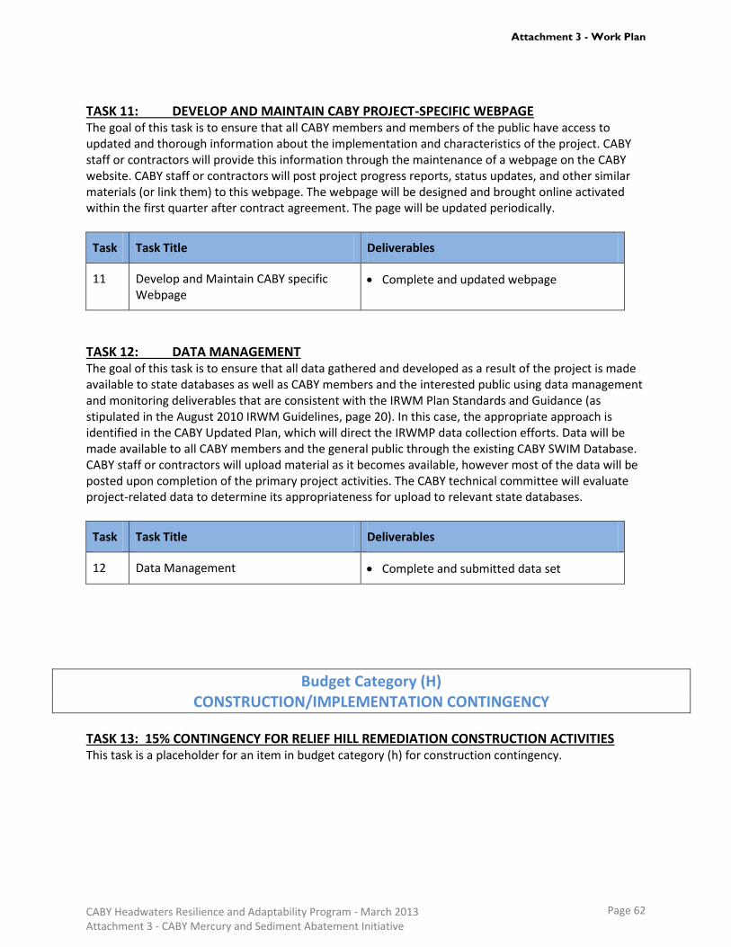
TASK 11: DEVELOP AND MAINTAIN CABY PROJECT-SPECIFIC WEBPAGE The goal of this task is to ensure that all CABY members and members of the public have access to updated and thorough information about the implementation and characteristics of the project. CABY staff or contractors will provide this information through the maintenance of a webpage on the CABY website. CABY staff or contractors will post project progress reports, status updates, and other similar materials (or link them) to this webpage. The webpage will be designed and brought online activated within the first quarter after contract agreement. The page will be updated periodically.
Task Task Title Deliverables
11 Develop and Maintain CABY specific Webpage
Complete and updated webpage
TASK 12: DATA MANAGEMENT The goal of this task is to ensure that all data gathered and developed as a result of the project is made available to state databases as well as CABY members and the interested public using data management and monitoring deliverables that are consistent with the IRWM Plan Standards and Guidance (as stipulated in the August 2010 IRWM Guidelines, page 20). In this case, the appropriate approach is identified in the CABY Updated Plan, which will direct the IRWMP data collection efforts. Data will be made available to all CABY members and the general public through the existing CABY SWIM Database. CABY staff or contractors will upload material as it becomes available, however most of the data will be posted upon completion of the primary project activities. The CABY technical committee will evaluate project-related data to determine its appropriateness for upload to relevant state databases.
Task Task Title Deliverables
12 Data Management Complete and submitted data set
Budget Category (H) CONSTRUCTION/IMPLEMENTATION CONTINGENCY
TASK 13: 15% CONTINGENCY FOR RELIEF HILL REMEDIATION CONSTRUCTION ACTIVITIES This task is a placeholder for an item in budget category (h) for construction contingency.
CABY Headwaters Resilience and Adaptability Program - March 2013 Attachment 3 - CABY Mercury and Sediment Abatement Initiative
Page 62
Attachment 3 - Work Plan

WORKPLAN REFERENCES
The following references correspond to citations in the above Work Plan for the CABY Mercury and Sediment Abatement Initiative. Selected documents are also provided in PDF form as supplementary materials to this proposal – see Attachment 8 Technical Justification for a list of attached documents. Alpers, C.N., Kakouros, E. and et.al. 2010 The Effects of Sediment and Mercury Mobilization in the South Yuba
River and Humbug Creek Confluence Area, Nevada County, California: Concentrations, Speciation, and Environmental Fate – Part 2: Laboratory Experiments. Open-File Report 2010-1325B. U.S Department of the Interior, U.S. Geological Survey
Alpers, C.N., Kakouros, E. and et.al. 2010 The Effects of Sediment and Mercury Mobilization in the South Yuba
River and Humbug Creek Confluence Area, Nevada County, California: Concentrations, Speciation, and Environmental Fate – Part 1: Field Characterization. Open-File Report 2010-1325B. U.S Department of the Interior, U.S. Geological Survey
Alpers, C.N., Hunerlach, M.P., May, J.T., and Hothem, R.L., 2005a, Mercury contamination from historical gold
mining in California: U.S. Geological Survey Fact Sheet 2005–3014, version 1.1, 6 p. Alpers, C.N., Hunerlach M.P., May J.T., Hothem R.L., Taylor H.E., Antweiler R.C., De Wild J.F., and Lawler D.A..
2005b. “Geochemical Characterization of Water, Sediment, and Biota Affected by Mercury Contamination and Acidic Drainage from Historical Gold Mining, Greenhorn Creek, Nevada County, California, 1999–2001.” U.S. Geological Survey Scientific Investigations Report 2004-5251. 278 p
Alpers, C.N., May, J.T., Hothem, R.L., May, T.W., and Saiki, M.K., in preparation. Mercury bioaccumulation in the
Bear River watershed, northwestern Sierra Nevada, California, 2003‐06. USGS Open‐File Report. Alpers, C.N., Stewart, A.R., Saiki, M.K., Marvin-DiPasquale, M.C. Topping, B.R., Rider, R.O., Gallanthine, S.K.,
Kester, C.A., Rye, R.O., Antweilier, R.C. and De Wild, J.F., 2008, Environmental factors affecting mercury in Camp Far West Reservoir, 2001-03. U.S. Geological Survey Scientific Investigations Report 2006-5008, 358 p.
CALFED. 2007. Fish Mercury Project, Year 1 Annual Report, Sport Fish Sampling and Analysis. Collaborating
parties: San Francisco Estuary Institute, California Department of Fish and Game, Moss Landing Marine Laboratories, California Office of Environmental Health Hazard Assessment. Final Technical Report. May 2007.
CALFED. 2007. Fish Mercury Project, Year 2 Annual Report, Sport Fish Sampling and Analysis. Collaborating
parties: San Francisco Estuary Institute, California Department of Fish and Game, Moss Landing Marine Laboratories, California Office of Environmental Health Hazard Assessment. Final Technical Report. October 2007
CDOC (California Department of Conservation). 2003. Abandoned Mine Lands Assessment of the North Yuba
Watershed. CA Department of Conservation Abandoned Mine Lands Unit. http://www.conservation.ca.gov/omr/abandoned_mine_lands/Documents/North%20Yuba.pdf
Cal/EPA (California Environmental Protection Agency). December 2003. Evaluation of Potential Health Effects of
CABY Headwaters Resilience and Adaptability Program - March 2013 Attachment 3 - CABY Mercury and Sediment Abatement Initiative
Page 63
Attachment 3 - Work Plan

Eating Fish from Selected Water ways in the Northern Sierra and Guidelines for Fish Consumption. CDPH (California Department of Public Health). 2005. “Delta-San Joaquin River Pilot Angler Survey.” CDPH
Environmental Health Investigations Branch, Richmond, CA. Churchill, R., 1999, Insights into California mercury production and mercury availability for the gold mining
industry from the historical record. Geological Society of America Abstracts with Program, v. 31, no. 6, p. 45. Churchill, R.K. 2000. Contributions of Mercury to California’s Environment from Mercury and Gold Mining
Activities – Insights from the Historical Record. Extended abstracts for the U.S. EPA-sponsored meeting, Assessing and Managing Mercury from Historic and Current Mining Activities.
CVRWQCB (Central Valley Regional Water Quality Control Board), 2010 CWA Section 303(d) List of water quality
limited segments requiring TMDLs, accessed Feb. 27, 2011 at: http://www.swrcb.ca.gov/water_issues/programs/tmdl/docs/303dlists2006/epa/r5_06_303d_reqtmdls.pdf
Davis, J.A., Melwani, A.R., Bezalel, S.N., Hunt, J.A., Ichikawa, G., Bonnema, A., Heim, W.A. Crane, D., Swenson, S.,
Lamerdin, C., Stephenson, M., 2010, Contaminants in Fish from California Lakes and Reservoirs, 2007-2008: Summary Report on a Two-Year Screening Survey. A Report of the Surface Water Ambient Monitoring Program (SWAMP). California State Water Resources Control Board, Sacramento, CA.
DTMC (Delta Tributaries Mercury Council). 2002. Strategic Plan for the Reduction of Mercury-related Risk in the
Sacramento River Watershed DWR (Department of Water Resources). 1987. Erosion Control at Malakoff Diggins State Historic Park; Report to
the Department of Parks and Recreation Interagency Agreement 05-07-075 (DWR 163543). Central district January 1987
Fish Mercury Project. June 2006. Report of Fishing Activities in the North Delta and Sacramento River Watershed. Foe, C.G., 2003, Mercury Mass Balance for the Freshwater Sacramento-San Joaquin Bay-Delta Estuary. Final
report submitted to the CALFED Bay-Delta Program for the project: An Assessment of the Ecological and Human Health Impacts of Mercury in the Bay-Delta Watershed (Task 1A). California Regional Water Quality Control Board, Central Valley Region. Sacramento, CA. (<http://mercury.mlml.calstate.edu/reports/2003-reports/>)
Forest Service. 2004a. “Biological Evaluation, Birds, Mammals, Amphibians, Reptiles, Fish, Invertebrates,
Washington Project, Downieville/Nevada City District, Tahoe National Forest.” Prepared by Marilyn Tierney, District Biologist. April 2.
Forest Service. 2004b. “Relief Hill CERCLA, Archeological Inventory, (FS 05-17-55-330), TNF 1939/R2004-0517-
00110.” Prepared by William Slater, District Archeologist, Yuba River Ranger District. September. Forest Service. 2004c. “Weed Risk Assessment, Relief Hill Mine Project, Yuba River Ranger District, Tahoe
National Forest.” Prepared by Kathy Van Zuuk, District Ecologist. October 5. May J.T., R.L. Hothem, C.N. Alpers, and M.A. Law. 1999. Mercury Bioaccumulation in Fish in a Region Affected by Historic Gold Mining: The South Yuba River, Deer Creek and Bear River Watersheds. USGS 00-367.
CABY Headwaters Resilience and Adaptability Program - March 2013 Attachment 3 - CABY Mercury and Sediment Abatement Initiative
Page 64
Attachment 3 - Work Plan

Minear, J. T., and G. M. Kondolf (2009), Estimating reservoir sedimentation rates at large spatial and temporal
scales: A case study of California, Water Resour. Res., 45, W12502, doi:10.1029/2007WR006703. NID (Nevada Irrigation District), 2009, Combie Reservoir Mercury Extraction Project CEQA Mitigated Negative
Declaration, Notice of Determination. (9-25-2009) NID (Nevada Irrigation District), 2012a. Combie Reservoir Mercury Extraction Project CEQA Initial Study. Nevada Irrigation District (NID), 2012b. Antidegradation Analysis for the Combie Reservoir Sediment and Mercury
Removal Project. Appendix IV Pegasus Mercury Extraction Test Results OEHHA (Office of Environmental Health Hazard Assessment). 2003. Health Advisory for Selected Water Bodies in
the Northern Sierra Nevada Foothills (Nevada, Placer, and Yuba Counties). OEHHA (Office of Environmental Health Hazard Assessment). June 2008. Development of Fish Contaminant Goals
and Advisory Tissue Levels for Common Contaminants in California Sport Fish: Chlordane, DDTs, Dieldrin, Methylmercury, PCBs, Selenium, and Tosaphene.
OEHHA (Office of Environmental Health Hazard Assessment). 2009. Update to California Sport Fish Advisories. PCWA (Placer County Water Agency). 2010 Middle Fork American River Project AQ11 Water Quality Technical
Study Report, (FERC No. 2079). Placer County Water Agency. SAIC (Science Applications International Corporation). 2004a. “Combined Preliminary Assessment/Site Inspection
Report, Relief Hill Hydraulic Mine Site, Tahoe National Forest.” January 26. SAIC (Science Applications International Corporation). 2004b. “Potentially Responsible Party Search, Relief Hill
Hydraulic Mine Site, Tahoe National Forest”. SFEI (San Francisco Estuary Institute). 2001. San Francisco Bay Seafood Consumption Study. SFEI, Richmond, CA. Shilling F, A. White, L. Lippert, and M. Lubell. 2010. Contaminated fish consumption in California’s Central Valley.
Environ. Res. 110:334-344. SWRBC (State Water Resources Control Board). 1998. “Water Monitoring Quality Assurance Project Plan for the
Yuba Watershed Council Monitoring Committee”. Revision 1.4 July 2011 SWRCB (State Water Resources Control Board). 2006. “Public Meeting for Proposed Methylmercury Objectives for
Inland Surface Waters, Enclosed Bays, and Estuaries in California”. Informational Document SWRCB (State Water Resources Control Board), 2012. “Statewide Mercury Policy and Mercury Control Program
for Reservoirs”. Informational materials, CEQA scoping documents, and web resources. SYRCL (South Yuba River Citizens League), 2011, A 21st Century Assessment Tetra Tech (Tetra Tech EM Inc.) 2000, Water Quality Management for National Forest System Lands in California –
CABY Headwaters Resilience and Adaptability Program - March 2013 Attachment 3 - CABY Mercury and Sediment Abatement Initiative
Page 65
Attachment 3 - Work Plan

Best Management Practices. Pacific Southwest Region, Vallejo, CA. (prepared for USFS by Tetra Tech). Tetra Tech EM Inc. (Tetra Tech). 2006. “Technical Memorandum Number 3: Site Characterization and Risk
Screening Evaluation, Relief Hill Hydraulic Mine, Nevada County, California.” February. Tetra Tech (Tetra Tech EM Inc.). 2007. Final Engineering Evaluation and Cost Analysis Relief Hill Hydraulic Mine,
Nevada County California (prepared for USFS by Tetra Tech). TSF (The Sierra Fund). 2011. Gold Country Angler Survey; A pilot Study to Assess Mercury Exposure from Sport
Fish Consumption in the Sierra Nevada. TSF (The Sierra Fund). 2013. Humbug Creek Watershed Assessment and Management Plan Upper Yuba River Studies Program Study Team. 2006. Draft Englebright Lake Creel Survey Technical Report.
Available at: http://www.water.ca.gov/fishpassage/docs/yuba/yuba_creel.pdf.Weiner et al. 2003a Wiener, James G., Krabbenhoft, David P., Heinz, Gary H., and Scheuhammer, Anton M. 2003. Ecotoxicology of
Mercury in “Handbook of Ecotoxicology.” Second Edition. Hoffman, David J., Rattner, Barnett A., Burton, G. Allen Jr., Cairns, John Jr. Eds. Lewis Publishers. New York.
Wiener, J.G., Gilmore, C.C., and Krabbenhoft, D.P. (2003). Mercury strategy for the Bay-Delta Ecosystem: a
unifying framework for science, adaptive management, and ecological restoration. La Crosse, Wisconsin: University of Wisconsin.
Wood, M.L., Morris, P.W., Cooke, J., and Louie, S.J., 2010a, Amendments to the Water Quality Control Plan for the
Sacramento River and San Joaquin River Basins for the Control of Methylmercury and Total Mercury in the Sacramento-San Joaquin Delta Estuary Staff Report, April 2010, 331 p. plus appendices.
Wood, M.L., Foe, C.G., Cooke, J., Louie, S.J., 2010b, Sacramento – San Joaquin Delta Estuary TMDL for
Methylmercury Staff Report, Draft Report for Public Review, February 2010, 233 p.
CABY Headwaters Resilience and Adaptability Program - March 2013 Attachment 3 - CABY Mercury and Sediment Abatement Initiative
Page 66
Attachment 3 - Work Plan