cadastr al data in tur key who we are? - fig · 1 cadastr al data manag ement system in tur key dr....
TRANSCRIPT
1
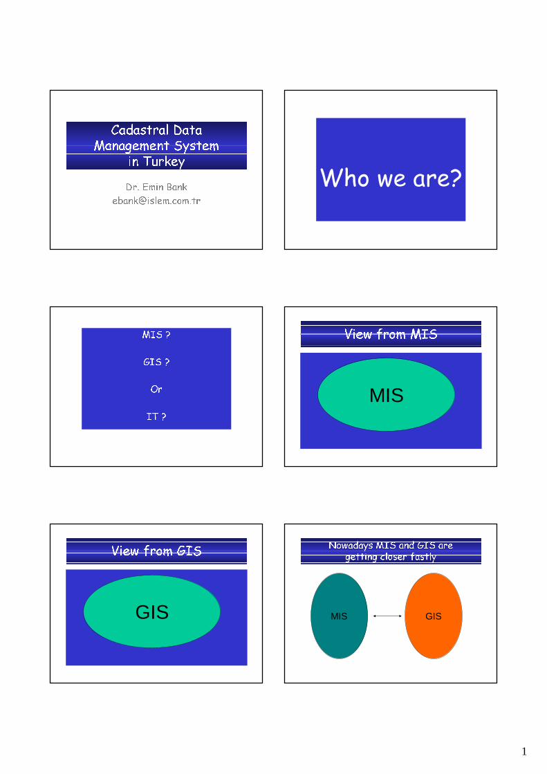
Cadastral Data Management System
in Turkey
Dr. Emin Bank
Who we are?
MIS ?
GIS ?
Or
IT ?
View from MIS
MIS
View from GIS
GIS
Nowadays MIS and GIS are getting closer fastly
GISMIS

2
Viewing from MIS is changing
MIS GIS
Viewing from GIS is changing
GIS MIS
IT
GISMIS
IT
Consumers/Consumers/CitizensCitizens
ITITUsersUsers
ITIT ProfessionalsProfessionals
Research Research CommunityCommunity
100’s of Millions100’s of Millions
Hundreds ofHundreds ofThousandsThousands
ThousandsThousands
View andView andLeverage the Leverage the InformationInformation
Build & ManageBuild & Managethe Infrastructurethe Infrastructure
Develop the Develop the ScienceScience
UseUseKnowledgeKnowledge
ITIT Community Will GrowCommunity Will Grow
MillionsMillions
IT
GIS: Cadastre
MIS: Land Registry
IT
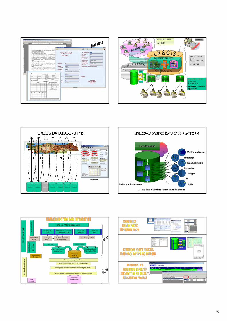
TURKISH LAND REGISTRY AND CADASTRE SYSTEM (LR&CIS)
• The studies has began in early 2001. • 3 months for analysis studies, • 3 months for design studies, • 16 months for software development
studies• it has been implementing for 14 months on
actual distrubuted sites– General Directorate, – one Regional Directorate, – 6 land registery and 2 cadastre offices

3
MAIN CHARACTERISTICS OF
PROJECT
• It is integrated with Land Registry system• It is a parcel-based system• It contains geometric cadastral
information and proprietary information with respect to ownership.
• It covers all Land Registery and Cadastre activities carried out in Regional Directorates (25), in Land Registery (1003)and Cadastral (325) Offices.
LR&CIS
Complex ApplicationsComplex Applications
Powerful Powerful GIS SoftwareGIS SoftwareQualified PersonelQualified Personel
COMPONENTS OF LR&CIS..
Powerful HardwarePowerful Hardware
Updated and Accurate DataUpdated and Accurate Data
•PROJECT MANAGER (1)
•LAND REGISTER / CADASTRE SYSTEM MANAGER (2)
•SYSTEM ANALYST (24)
•DATABASE EXPERT (4)
•PROGRAM DEVELOPPER (24)
•DATA ENTRY OPERATOR (40)
•HARDWARE/NETWORK EXPERT (6)
•LAND REGISTRY/CADASTRE EXPERT (4)
STAFF OF LR&CIS..
SQL SERVERSQL SERVER
ArcSDE ServicesArcIMS Services
DOMAIN DOMAIN CONTROLLER CONTROLLER EXCHANGEEXCHANGE
BACKUP DOMAIN BACKUP DOMAIN CONTROLLER CONTROLLER SERVERSERVER
PROXY SERVERPROXY SERVER
NetworkNetworkFire Wall
NetworkNetworkFire Wall
Land Registry App.
SOFTWARE ARCHITECTURE
ArcEditor +Cadastre App.
SYSTEM ARCHITECTURE
Database Database serverserver
Land Registry offices
(1003 Adet)
Cadastre chiefs
(100 Adet)Regional Dırectorates
(22 Adet)Cadastre offices
(325 Adt)
Application Application serverserver
Exchange Exchange serverserver
WEB serverWEB server

4
CADASTRAL DATA CONTENT AND
DEFINATIONS
-Geometric data : composed of quarter or village boundaries,blocks, parcels, parcel segments, parcel corner points, ground control points, and buildings
-Attribute data : owners, rights, mortgages, annotations should be defined and registered with geometric data at the same time.
PARCEL CORNER POINT
PARCEL SEGMENTPARCEL POLYGON
CADASTRAL SYSTEM CYCLE
FIELD
MeasurementsMeasurements
Parcel CornerPointsParcel CornerPoints
ParcelParcel
CADASTRE
SITE
REGISTRATION
SITE
Data Sets Feature Classes Geometry
Administrative Boundary
Province Polygon
County Polygon
Property Village/Quarter boundary Polygon
Block Polygon
Parcel Polygon
Parcel Corner Point Point
Parcel Segment Line
Servitude Polygon
Ground Corner Points Point
Project Area Working Area Polygon
Construction Building Polygon
Numbering Point
Rules and Relationships
• A parcel must be in a block or Village/quarter,
• A block must be in a Village/Quarter,
• A Village/Quarter must be in a County and a County must be in a Province
Province
County
Village/Quarter
Block
Parcel
Building
Parcel Corner Point
Parcel Segment
Numbering
Province
County
Village/Quarter
Block
Parcel
Building
Parcel Corner Point
Parcel Segment
Numbering

5
In Geodatabase In Registration Domain listBoundary of provincies, county, quarter
NameReference CodeShape Area
Block NumberShape Area
Parcel Polygon Block NumberParcel Number/NameShape AreaSheet Name
OwnerShareRightsMortgageDeclerationParcel Type XRegistred Area
Parcel Segment Graphical lenghtMeasurment lenghtSegment line type X
Parcel Corner Point NumberProduction method XProduct by Organization XProduct date
Building Building Type XGround Control Point Number
Measurment type XCoordinate X ValueCoordinate Y ValueCoordinate Z Value
STATISTICS OF TURKEY AREA
TYPE OF AREA km2 %
Forest 202,280.00 26.0
Pasture 96,000.00 12.3
Cadastral Arae (Rural) 440,000.00 56.6
Cadastral Area (Residential) 40,000.00 5.1
TOTAL 778,000.00 100.0
STATISTICS OF TURKEY AREA
RESIDENTIAL AREA RURAL AREA
TOTAL COMPLETEDNUMBER OF PARCEL
PRODUCED AREA (KM2)
TOTAL COMPLETEDNUMBER OF PARCEL
PRODUCED AREA (KM2)
8,636 8,277 5,879,813 39,214,480 37,223 25,838 28,459,864 332,787,793
6
LR&CIS CENTER
(DATA INFRASTRUCTURE)
ArcSDE
CADASTRE OFICCES
(PROCESS AUTOMATION)
ArcEditor + Cadastre Application
MONITORING(EXTERNAL USERS)
ArcIMS
WINDOWS 2000
SQL/SERVER DBMSTITLE DEED
SQL/SERVER 2000GeoDBCADASTRE
Check outCheck out
Check inCheck in
LR&CIS KM
27 30 33 36 39 42 45
GeoDB_27 GeoDB_30 GeoDB_33 GeoDB_36 GeoDB_39 GeoDB_42 GeoDB_45
MAPPING
LR&CIS DATABASE (UTM)
. . . . . . File and Standart RDMS managementFile and Standart RDMS management
Rules and behavioursRules and behaviours
Vector and rasterVector and raster
TopologyTopology
NetworksNetworks
TINTIN
MeasurementsMeasurements
ImagesImages
CADCAD
GeodatabaseGeodatabase
LR&CIS-CADASTRE DATABASE PLATFORM
Digital / Nondigital Data
Data C
olle
ction
Co
nverting
G
IS
Envio
renm
ent
Data In
tegration
Intermediate Product
Data P
rodu
ction
Generation Integration Tables
Matching Cadastre and Land Registre Data
Investigating of unmatched data and solving the them
Transfering data from candidate database to final database
Intermediate Product
Final Product
Land Registry TablesCadastre Personel Geodatabase
Covarage Files
Existing CAD Data
Observation Values in Cadastre Archive
Digital Title Deed Data
Title Deed Files
Candidate LR&CIS
Database
Data Load Data Converting
Candidate Cadastre Geodatabase
Candidate Land Registry Database
Final database
Check outCheck out
Check inCheck in
LR&CISKM

7
WATER AND SEWERAGEWATER AND SEWERAGE
NATURAL GASNATURAL GAS
CITIZENCITIZENTAXTAX
PIPE LINEPIPE LINE
COMMUNICATIONCOMMUNICATION
AGRICULTUREAGRICULTURE
ELECTRICITYELECTRICITY
TRANSPORTATIONTRANSPORTATIONBANKBANK SS
FORESTFOREST
JUSTICEJUSTICE
MUNICIPALITYMUNICIPALITY
PUBLIC WORKSPUBLIC WORKS
CULTURECULTURE
EXTERNAL USERS OF LR&CIS...

8

9
Conclusion
• At this moment cadastral data is living with it’s weakless of accuracy, currency and quality.
• In the future, data improvement proccess shoul be taken as a big project, planned, and solved in a specific time by the CadastreOrganization.
• Data quality should be classified and shoul be proccessed with in accordince it’s quality
• Data shoul be riched with other data like worth of parcel, tax value and land use in order to establish a multi purpose of cadastral system.
• Cadastre organization should be reorganize in accordace with this system.
• Personnel qualification should be increase with training.• The body of current laws and regulations should be improve
accordance with technologic developments. ,
AT THE END OF PROJECT...AT THE END OF PROJECT...
FUTURE OF PROJECT..
DBMSDBMS
DBMSDBMS
DBMSDBMS
DBMSDBMS
DBMSDBMS
DBMSDBMS
DBMSDBMS
DBMSDBMS
DBMSDBMS
ALL UNITS OF ALL UNITS OF
GDLRC WILL BE GDLRC WILL BE
CONNECTED EACH CONNECTED EACH
OTHEROTHER
ALL PROSEDURES ALL PROSEDURES
SHALL BE MONITORED SHALL BE MONITORED
DYNAMICLYDYNAMICLY
IT SHALL BE IT SHALL BE
POSSIBLE TO POSSIBLE TO
ACCESS UPDATED ACCESS UPDATED
DATA DYNAMICLYDATA DYNAMICLY