caldwell, david h. (2010). finlaggan report 1...
TRANSCRIPT

Caldwell, David H. (2010). Finlaggan report 1: introduction and background. National Museums Scotland
Deposited on: 26 November 2010
NMS Repository – Research publications by staff of the National Museums Scotland
http://repository.nms.ac.uk/
1

FINLAGGAN, ISLAY – THE CENTRE OF THE LORDSHIP OF THE ISLES
EXCAVATIONS AND FIELDWORK 1989 – 1998
PART 1 – INTRODUCTION AND BACKGROUND
DIRECTED BY DAVID H CALDWELL
ON BEHALF OF NATIONAL MUSEUMS SCOTLAND
PRE‐PUBLICATION TEXT – SUBJECT TO CHANGE; FULL TEXT NOT AVAILABLE
Up‐dated 1 November 2010 2

3
CONTENTS
Introduction 3
Periods and dates 7
The Geographical background 8
Islay – overview 8
The study area 9
Geology 11
Soils, vegetation and catchment land use 12
Places and people in the study area 14
Extents and rentals 15
Feudal superiors 18
The lands 21
Finlaggan in history and tradition 33
The name Finlaggan 33
Finlaggan in history 34
Methodology 42
Documentary research 42
Archaeological survey 42
Geophysical prospection 44
Excavation 44
Dating 47

4
INTRODUCTION
In 1988 the Trustees of the National Museums of Scotland expressed a desire that the Museums should undertake an archaeological research excavation in Scotland. The Finlaggan Archaeological Project is the result. The initial reasons for choosing Finlaggan was that it was an important medieval centre, the study of which might lead to a greater understanding of a region of Scotland, little studied and understood. The Museums contain important material from the medieval West Highlands and such a project might help to provide more information on it, and more objects for display.
Two islands in Loch Finlaggan were identified as the historic site, and the focus of the research project. Both islands, Eilean Mor and Eilean na Comhairle (the Council Isle) were scheduled ancient monuments, and it was therefore also crucial to convince Historic Scotland of the merits of the project and receive the necessary permission to dig. Excavation commenced in 1990 and remained almost totally confined to the two islands, but we soon realised the desirability of setting this work in a wider context. Our fully developed strategic plan for the project had the following five objectives.
Firstly, we desired a greater understanding of what was happening in the Western Isles, particularly, but not exclusively, in the Middle Ages. The Lordship of the Isles has long been recognised by historians as an important phenomenon, a serious challenger to the Stewart dynasty for control of much of Scotland. The documentation for it, however, is exceedingly thin, and archaeology now offers the best way forward to gaining a better understanding of it. It seemed clear to us when we started the project that Finlaggan was the type of site which would have good archaeological deposits of the Medieval Period, and this has been amply borne out by our work. Other excavations on medieval sites in the West Highlands have been so few and far between that we did not consider we ran any risk of needlessly duplicating other researchers' results.
Finlaggan has already been identified as the centre of the Lordship of the Isles by several historians. In particular, a new edition in 1961 by R W Munro of Dean Monro's 1549 description of the Western Isles brought renewed attention to the early traditions of inauguration ceremonies for the Lords of the Isles at Finlaggan, and the meetings there of the Council of the Isles. It is obviously a site of national importance, and a second objective of our work was to throw some light on Finlaggan as a centre. We were encouraged by the recent formation of the Finlaggan Trust, with its committee and much of its membership based on Islay. We believed -
5
rightly - that the support and collaboration of such a body would help in the development of the project.
The Trust recognises there is increasing interest in Finlaggan and is intent on encouraging this by making visits to the site easy, enjoyable and informative, while at the same time managing access so that wear and tear to the place is kept to an absolute minimum, the integrity of the remains is not compromised or violated, and the process of decay to the upstanding remains is arrested. Archaeology is a necessary part of such schemes whether as part of the conservation programme on upstanding structures or as a means of explaining the significance of different features on the site. It was, therefore, an important aspect of our project that we should co-operate with the Trust.
Our third objective was to explain why Finlaggan was a site of such strategic importance in the Lordship of the Isles. We postulated as possible reasons for this the relative quality of the land for agriculture and/or stock-rearing, the exploitation of deposits of lead and silver, and ceremonial traditions extending backwards to earlier times. We further proposed that Finlaggan might have acted as a centre for the redistribution of the surplus food and other commodities produced in the Lordship, a place where people gathered, perhaps at set times or seasons, to do business, where law was dispensed and administrative arrangements made. The programmes of environmental work, fieldwork and excavation initiated by us were designed to evaluate these ideas.
Fourthly, our commitment to Finlaggan gave us the opportunity to make a wide-ranging archaeological study of a compact area of land, defined as the area around Loch Finlaggan, in geographical terms taking in the catchment area for the loch, and including the old farms of Portaneilean, Mulreesh, Robolls, Kepollsmore and Sean-ghairt as shown on the map derived from the mid 18th-century survey by Stephen MacDougall. While appreciating Finlaggan's unique importance as a centre in the Medieval Period, it was also our objective to place this in the wider context of man's use of this part of Islay from his first arrival on the island to the present day. We anticipated that our environmental programme in particular would demonstrate man's impact on, and use of the land at Finlaggan in prehistoric times. We were impressed by the survival of medieval and more recent buildings, field systems, and mining remains in the vicinity of Finlaggan. Documentary evidence for the Post-Medieval Period suggested that Finlaggan had no special status after the collapse of the Lordship and we hoped that a fieldwork survey would not only provide a context for the later history of Finlaggan but be a suitable paradigm for more recent developments elsewhere in the West Highlands.

6
Fifthly, because Finlaggan has been perceived all along as a research project, we wanted to encourage other research initiatives, using Finlaggan material. Thus this volume contains a detailed study by Dr Cressey of the medieval and later lead mining industry on Islay. The work of our geologist, Nigel Ruckley, has been used as the basis of a wider study of masonry techniques in the Lordship of the Isles.
The detailed examination of our Finlaggan study area has been set in context with essays on the history of Islay and the West Highlands and Islands in the Medieval Period. The writer has considerable sympathy with the view of the seventeenth-century MacDonald historian who complained that previous Scottish historians were `partial pickers of Scottish chronology and history [and] never spoke a favourable word of the Highlanders, much less of the Islanders and MacDonalds, whose great power and fortune the rest of the nobility envied’ (Highland Papers, i, 10). A full reassessment of the contribution of Highland culture to the story of Scotland is still a worthy aim and it is hoped that this volume will contribute to that in a positive way.
We do not pretend that we have totally succeeded in dealing with our objectives or that there are not other matters that we could or should have given attention to. I hope, nevertheless, that it will not appear presumptuous to suggest that renewed interest in the historic site of Finlaggan and improved access to it are the most important achievements of the project. Of course, it is primarily the Finlaggan Trust which has been responsible for this, but I believe we have in no small measure helped. Before the excavations commenced Finlaggan was little visited, even by the islanders, and reaching the site involved a pot-holed track barred by three gates, a muddy field and a boat-crossing.
Now the Finlaggan Trust have an excellent visitor centre with ample parking space. The track is asphalted, and the main island can be reached by timber walkways and a bridge. The Trust has a programme in place for the conservation and display of the ruins, and already much has been done. There are discreet display panels which do not detract from the overall appearance of the place. It is also apparent that not only many islanders have now visited and enjoyed Finlaggan but it is also a must for most visitors to Islay.
Not included in this volume, but of great importance in the development of the project is a digitised Islay Cultural Database [ICD], largely the work of Roger McWee. Work was started on it, purely with the intention of providing a tool for the writer and his colleagues in forming an overview of Islay. The core of the ICD was all the information on Islay places contained in the Name Books compiled in 1878

by the surveyors for the first edition Ordnance Survey map of the island. To this was added information on place names, illustrations, archaeological and historical data, rentals, census material, local family histories, etc.
It soon became apparent that the ICD could be of direct benefit to many others, and so efforts have been made to make it more user-friendly, and copies of it have been made available for public access at the Finlaggan Visitor Centre and the Museum of Islay Life in Port Charlotte. It should now be possible for an interested enquirer to search for - and recover - information on any place or known person (prior to the mid 19th century) on Islay, and easily make appropriate links.
We have now consulted widely on the use and future development of the ICD and hope that it will be maintained as an essential and readily available tool for all interested in Islay. It, as much as this volume, is the outcome of the Finlaggan Research Project.
7

8
PERIODS AND DATES
Age Date Lordship Period Chronological markers
Mesolithic 9000-4000 BC
Neolithic 4000-2500 BC
Bronze Age
2500-750 BC
Iron Age 750 BC – 500 AD
Prehistoric
Early Historic
500 – 800 Cenél nÓengusso,
Dál Riata
Phase I 563 St Columba comes to W Isles
Earlier Medieval
800 - 1100 Phase II 794 first recorded Viking raid on W Isles
Kingdom of the Isles
Phase III 1079 Godred Crovan becomes King of the Isles
Later Medieval
1100 - 1500
Lordship of the Isles
Phase IV 1266 Treaty of Perth – W Isles become part of Scotland
Post-Medieval
1500 - 1600 MacIans, MacDonalds
Phase V 1499 Leaders of Clan Donald captured at Finlaggan
Early Modern
1600 - 1700 Campbells of Cawdor
1614 John Campbell of Cawdor acquires Islay
Recent 1700 - Campbells of Shawfield, Morrisons
Modern/Recent
1726 Islay acquired by Daniel Campbell of Shawfield
1853 Islay acquired by James Morrison

9
THE GEOGRAPHICAL BACKGROUND
ISLAY - OVERVIEW
Islay is one of the main islands of the Inner Hebrides, 19 miles wide and 25 miles from N to S, with an area just over 600 square kilometres. It is the furthest S of the group, lying at about the same latitude as Glasgow and Edinburgh, about 15 miles to the W of the peninsula of Kintyre, and only about 23 miles from the NE coast of Ireland which is often clearly visible. It is separated from the neighbouring island of Jura to the E by the narrow Sound of Islay. The climate is maritime and influenced by predominantly westerly winds. The average rainfall tends to be high with between 1300mm and 1600mm per year.
A wide inlet of the sea, Loch Indaal, dissects the island's broad SW flank. To the NW of this loch is the peninsula known as the Rhinns, an island until the time of Christ, separated from the rest of Islay by a narrow channel extending from Loch Gruinart in the N down to Loch Indaal (Dawson & Dawson 1997b, 97). The Rhinns forms the parish of Kilchoman. At the southern extremity of Islay is another peninsula, rounded and smaller than the Rhinns, called the Oa, which, with the adjacent coastal areas extending north-eastwards to the Sound of Islay and northwards along Laggan Bay to the River Laggan, is the parish of Kildalton and Oa.
The rest of the island comprises the conjoined parish of Kilarrow and Kilmeny, including a broad central valley extending from the head of Loch Indaal almost to the Sound of Islay. It is watered by the River Sorn which is fed via the Ballygrant Burn by Loch Ballygrant, and via the Abhuinn Gleann Mhartuin by Loch Finlaggan.
The geology of Islay is complex, with numerous intrusions and dykes. The main part of the island and the Oa comprises mostly Dalradian metamorphic rocks such as quartzites, limestones and phyllites. The Rhinns consists, basically, of rocks of Pre-Cambrian age, Lewisian gneiss in the southern half and Torridonian grits, slates and conglomerates in the rest.
Islay has a variety of different landscape types, including sand dunes and machair, Lowland bog and moor, rocky moorland, coastal parallel ridges, and, predominantly, moorland plateau (Environmental Resources Management 1996, 63ff). It is also, compared with the other Hebrides, a fertile island. In a memorial

10
prepared for the laird of Islay in 1780 (Ramsay 1991, 180) it was reckoned that the island had 114,000 acres of which 27720 (24.3%) were in tillage and 8507 (7.5%) grass or green pasture. The figure for tilled or arable land is likely to have risen even higher at the time of maximum population density in the early 19th century. There is farmland on the raised beaches around Loch Indaal, and on the machair in the northern half of the Rhinns around Lochs Gorm and Gruinart. Some of the best is to be found in areas where the underlying rock is metamorphosed limestone, including the N end of Loch Finlaggan. Very little of this farmland is now cropped with anything but grass, and none of it is rated highly in the land capability map produced by the Macaulay Institute for Soil Research. At best, a little of it is deemed suitable for producing a moderate range of crops, and most of it is only considered appropriate for improved grassland and rough grazings.
However, pre-improvement farmers with limited equipment may not have found that this apparent soil poverty affected them adversely. Many of the soils on the island could readily be dug by spade and were light enough to be cultivated by primitive ploughs. Ready local supplies of limestone for use as a fertiliser were also a significant factor. Extensive tracts of peat, covering as much as 25% of the island, are still a valuable source of fuel.
THE STUDY AREA
By MICHAEL CRESSEY
Loch Finlaggan is situated in the NE of Islay and is the longest loch on Islay with a length of approximately 1 km, an area of 63.4 ha and a catchment of approximately 610 ha. The loch basin is a glacially-deepened valley running SW by NE along a major fault line (The Finlaggan Fault). The W side of the loch rises from 50m to the summit of Cnoc an Tighe at over 170m above sea level. The E shore rises to 130m at Robolls Hill (illus 1). In general, the E and W shores are stony with little in the way of established marsh. The catchment area is mostly rough grazing, 45.7% now planted with conifers.
There are numerous springs and small burns feeding into the loch from both sides of the valley. The major inlet of water into the loch is via the Finlaggan Burn that flows along the aforementioned fault line, entering the loch opposite the tip of Eilean Mor in one clearly defined channel. There are two other channels, however, now silted up, suggesting that the regime of the burn may have changed considerably over the years. There are also clear signs around the loch edge of a shore line over a metre higher than the present one. Agricultural drainage of the fields of Finlaggan Farm, mining activity, and afforestation will all be shown to be possible causes of this. The burn is 2.5m wide where it enters the loch but in

Illus 1. Map of area around Loch Finlaggan
11
12
adverse conditions the discharge can be extreme when the burn bursts its banks and becomes a torrent over 10m wide. The difference in winter and summer water level on Loch Finlaggan is estimated to be in excess of 0.5m, varying between about 52.40m OD and 51.90 OD (on the basis of the site bench mark on Eilean Mor). Three islands are situated within the loch, including Eilean Mor and Eilean na Comhairle at the N end, and Eilean Mhuireill about half way along the E shore.
GEOLOGY
By NIGEL A RUCKLEY
The solid geology of the area consists of rocks of the Dalradian assemblage, thought to represent a marine rather than an estuarine environment such as that of the Grampian Moines. All the rocks have been metamorphosed during the Caledonian Period of mountain building about 500 million years ago when the sandstones, limestones and shales were metamorphosed into quartzite, cystalline limetones and slates respectively. The lower part of the Dalradian sequence – all that is represented on Islay - is probably of shallow water, possibly shelf sea in origin with characteristic rock types of current bedded quartzites, limestones and pelites. At Finlaggan the rocks are almost vertical in dip or very steeply dipping to the SE. They form part of the Islay anticline, the crest of which has been eroded away to reveal underlying slates (phyllites), quartzites and limestones.
An easily identifiable rock type is the Port Askaig tillite, covering a large area to the W of Loch Finlaggan. In geological sequence it lies between the younger Islay quartzites and the older underlying limestones. This tillite represents the boulder clay or till of an Ice Age of late Pre-Cambrian times, metamorphosed to produce a rock exhibiting pebbles, including granites and Nordmarkite, that are not derived from local material. They are set in a coarse quartzitic matrix.
The Port Askaig tillite and quartzite to the W of Loch Finlaggan is separated from the limestone around Finlaggan Farm by a NE/SW fault, not visible above ground). There are other areas of limestone to the E, S around the W of the loch. These limestones, blue-grey in colour when fresh, with prominent thin veins of calcite often exhibit slight mineralisation in the form of cubes of iron pyrites, less than 2mm across.
The bay at the head of the loch as well as much of the area to the E consists of grey-blue dark silty slate or phyllite with cubes of iron pyrites up to 5mm across.

13
Vulcanism to the NW of Islay caused a series of NW/SE quartz-dolerite dykes to be intruded into the already metamorphosed Dalradian rocks. Several of these are prominent features in the landscape on both sides of loch Finlaggan.
Islay was heavily glaciated at least three times during the Pleistocene Period, with the general trend of the ice movements towards the W or SW. Glacial deposits such as boulder clay, hummocky moraines and eskers can be found on the island – including an area of boulder clay on the W side of the loch.
SOILS, VEGETATION AND CATCHMENT LAND USE Within the Finlaggan catchment four soil-types are classified by the Macaulay Institute for Soil Research. The soils most useful for arable and grazing are designated as map unit 165 of the Deecastle Association. This type borders the NE and W regions of the catchment, including Eilean Mor, and there is a patch on the E of the loch on the slopes of Robolls Hill. The soil is derived from Dalradian limestone and phyllites.
An exposed soil section beside the road to Finlaggan farm-steading appears to be a typical example of a podzolic brown forest soil, as defined by Ragg et al. (1978). A thin humic A-horizon (topsoil) is separated from a very dark greyish brown (Munsell Soil Chart 10YR 3/2) layer of stoney silty sand by a band of small stones, representing the maximum depth of intensive earthworm activity. It also indicates that the ground here has not recently been broken up by tillage. The dark greyish brown layer is the B-horizon. Beneath the stone line is an iron pan, which in turn overlies a deposit of yellowish-brown (10YR 5/4) silty clay with some small stones, mostly flakes of phyllite. This is the C-horizon. Under it is the phyllite bedrock. Another similar section of map unit 165 soil on limestone can be observed beside a recently created farm track on the farm of Kepollsmore.
These soils are not rated highly for modern agricultural purposes. The ridges of rock which often break through to the surface inhibit the use of modern farm machinery. The Macaulay Institute has classed them as grade 5, land fit only for improved grassland and rough grazings. As pasture, however, their quality should not be underestimated for stock raising, and crops of oats, barley and potatoes were evidently successfully grown on them in the past by traditional means of farming.

14
Much of the region to the S and E of Loch Finlaggan is of the Foudland Series, its soils derived from the same phyllites and metamorphosed limestone as the Deecastle Association. Map unit 242, covering much of the land of Kepollsmore, includes gleys and brown forest soils. Map unit 253, including Robolls Hill, consists of poorly drained acid soils, mostly gleys. Soils of the Foudland Series are now classed (6/2, 6/3) as suitable only for rough grazing, though it is clear from the remains of old rigs and field systems that they have been extensively farmed in the past.
Organic soil, map unit 4, has developed on blanket peat overlying the quartzite bedrock at the N end of the loch. Neighbouring it on the W side of the loch is an area of soils, map unit 188, belonging to the Durnhill Association – peaty gleys and peat formed over glacial drift. These soils are now deemed to be of very limited value (class 6/3), fit only for rough grazing or afforestation. Evidence for these soils having been farmed in the past is restricted to a small area just to the W of the Finlaggan Burn, before it enters the loch.
In the study area the predominant herbaceous plants are the blanket bog flying-bent communities with a mixture of herb-rich fescue grassland. Calluna vulgaris is established over most of the acid soils. Marshland communities thrive in the regions susceptible to waterlogging with Carex sp. and Juncus conglomeratus. The shrubs Salix sp. and Myrica gale are well established along the sides of small burns that run down to the shoreline.
Meadow communities on the improved pasture include Ranunculus repens, Circium arvense, Vicia lutea and Rumex acetosa. To the NW of Loch Finlaggan on the peat and peaty gley soils an area of approximately 45.5% of the catchment was afforested with sitka spruce and lodge-pole pine by the Forestry Commission in 1982. At the S end of the loch a tract of abandoned coppice woodland survives, with stands of Corylus avellana and wind-stunted standards of Quercus sp. In all probability, the coppice may have been formed from secondary woodland (D. Boyd, former factor of Islay Estates, pers.comm.). No records survive of when this woodland was managed. Solitary wind-stunted birch and oak trees survive on the eastern side of the loch. At the northern end of the loch a well established tract of Phragmites australis forms a belt around the northern shore of Eilean Mor. At the southern end of the loch a mixture of Phragmites australis and Nymphaea alba give way to an extensive tract of marshland through which the outflow meanders eventually to form the River Sorn.

15
PLACES AND PEOPLE IN THE STUDY AREA
Note: the main sources of information for this chapter are a series of surviving rentals and other documents. To save repetitive reference to them in the text, their details are given here in date order:
1494 Charter by King James IV to John MacIan of Ardnamurchan of lands in Islay and elsewhere, and the office of bailiary of Islay (RMS, ii, no 2216; Islay Bk, 24-26).
1499 Charter by King James IV to John MacIan of Ardnamurchan of lands in Islay and elsewhere (Islay Bk, 28-30).
1506 Charter by King James IV to John MacIan of Ardnamurchan of lands in Islay and Jura (RMS, ii, no 3001; Islay Bk, 32-33).
1507 The ferms of Islay (ER, xii, 587-90).
1509 The ferms of Islay (ER, xiii, 219-221; Islay Bk, 484-5).
1541 Rental of Islay (ER, xvii, 633-41)
1542 Accounts of the receivers of ferms of Islay (ER, xvii, 541-56).
1562 Tack by Mary Queen of Scots to James MacDonald of Dunyvaig and the Glens of lands in Islay and Kintyre (RSS, v (i), no 1112; Islay Bk, 67-69).
1563 Tack by Mary Queen of Scots to James MacDonald of Dunyvaig and the Glens of lands in Islay and Kintyre (RSS, v (i), no 1259; Islay Bk, 70).
1564 Tack by Mary Queen of Scots to James MacDonald of Dunyvaig and the Glens of lands in Islay and Kintyre (RSS, v (i), no 1879: Islay Bk, 73).
1614 Charter by James VI & I to Sir John Campbell of Cawdor of the lands and island of Islay (RMS (1609-20), no 1137; Islay Bk, 199-230).
1628 Rental of Islay (Cawdor Muniments, bundle 655)
1629 Rental of Islay (Cawdor Muniments, bundle 655) 1630 Rental of Islay (Cawdor Muniments, bundle 655)
1631 Rental of Islay (Cawdor Muniments, bundle 655)
1632 Rental of Islay (Cawdor Muniments, bundle 655)
1641 Rental of Islay (Cawdor Muniments, bundle 655)
1642 Rental of Islay (Cawdor Muniments, bundle 655)
1643 Rental of Islay (Cawdor Muniments, bundle 655)
1654 Rental of Islay (Cawdor Muniments, bundle 655)
16
1686 Rental of Islay (Smith 1895, 490-520).
1694 A List of the Hearths within the shires of Argyll and Bute (NAS E69/3/1: Islay, pp 55-59)
1722 Rental of Islay (Islay Bk, 521-44).
1733 Rental of Islay (Islay Bk, 545-54; Ramsay 1991, 9-20).
1741 Rental of Islay (Islay Bk, 554-59; Ramsay 1991, 37-44).
1780 Rental of Islay (Ramsay 1991, 194-204).
1798-99 Rental of Islay (Ramsay 1991, 206-13).
1826/27 Rental of Islay (Islay Estates Papers)
1841 Census
1851 Census
1861 Census
EXTENTS AND RENTALS
The study area consists of the area around Loch Finlaggan, including its catchment and moorland to the N and W (illus 2). It corresponds to the area of the touns or farms of Portaneilean, Mulreesh, Robolls, Kepollsmore and Sean-ghairt, as shown on the map of Islay derived from the surveys by Stephen McDougall in 1749-51. This map does not show the lesser units of land like Cul a’ bhaile included in the main farms, and failed farms like Quinskirn, all memory of which has long since disappeared.
Prior to the mid 18th century Islay farms were measured not in terms of their area, but their `extent’, the sum of money the tenants of each were to produce each year for the landholder. These extents or valuations became a convenient way of describing the worth of different lands. Whereas the extent for many holdings remained the same from the 16th to the 18th century, the actual rent paid by the tenants increased with time and inflation. Thus the tenants of Sean-ghairt, a land with an extent of £1 13s 4d, were by 1722 required to pay £120 17s 4d Scots (£10 1s 5d Sterling).
The earliest surviving extent of the island dates to 1507, when it was assessed in a crown rental at £212 5s 4d Scots, including both the church lands and those in lay

Illus 2. Map of lands adjacent to Loch Finlaggan forming the study area.
17

18
hands. It is possible that this is an under-valuation, consequent on the difficulties experienced by the Crown in taking over the administration of the lands of the Lordship of the Isles. Reckoned as merks, this extent amounts to a bit over 318 whereas another estimate of Islay made at the end of the 16th century assesses it as 360 merks, that is £240 (Islay Bk, 111). On the other hand, by 1733 the Stent Committee for Islay reckoned the island amounted to 135 quarterlands, equivalent to an assessment of £225 (Ramsay 1890, 1), a figure nearer the extent of 1507.
The variations in these figures should teach some caution in interpreting fluctuations in the extent of individual lands over time. We should accept that individual farms might have their assessment changed because they were deemed more or less profitable and not just because segments of land have been added or subtracted. It should also be said that rentals do not always include some of the lands for reasons including they were wadset (mortgaged), in different ownership, or not currently rented. Nevertheless, as I hope to demonstrate below, it is possible to use the information provided by the rentals to locate otherwise unknown holdings.
The rental of 1507 was made for the Crown by John MacIan of Ardnamurchan who had been Bailie of Islay for the Lords of the Isles. Relying on the work of Lamont (1957, 1958, 1960 and 1966, 80-84) the process can be reconstructed as follows. MacIan set out with a list of the lands and their `old extent’. He also either had instructions as to what the new overall valuation for the island should be, or the rate at which it should be set – neither necessarily much different from what had gone before. In any case, as far as was practical, he listed the lands in ones or twos with a valuation per unit of 2½ marks (£1 13s 4d). It is probable that many of these units only made fiscal sense, and either contained other unnamed lands or were split amongst more than one tenant. This way of grouping Islay lands is already evident in the charter of lands and office of bailie awarded to MacIan by King James IV in 1494 (RMS, ii, no 2216). Units of land valued at 2½ marks were from then on one of the key features of Islay rentals. These were the so-called quarterlands. Half a quarterland was an auchtenpart or 16s 8d land, and quarter of a quarterland was a leorthas or 8s 4d land (there were even smaller fractions as well). The equation of a 2½ merk land with a quarterland is an underlying principle for understanding Islay extents and rentals. It was certainly true from the 16th century onwards but possibly not before MacIan’s valuation. Later rentals provide evidence of earlier units of assessment, particularly cowlands (kylands), so-called because each originally paid a yearly rent of a cow. The surviving rentals display signs that there was, inevitably, sometimes confusion about the extent of these earlier cowlands vis-à-vis the 2½ mark quarterlands and their fractions.

19
A brief explanation is required of the rentals of 1541-42, the only 16th-century ones to survive for the years between 1509 and 1628. They follow on from King James V’s expedition to the Western Isles in 1540 and his purchase of the MacIan inheritance (of which more below). The rentals of 1541-42 manifestly do not include all the lands of Islay, possibly only those where there were already compliant sitting tenants who were now up-graded to tenants of the Crown. In so doing, the king was attempting to squeeze out the MacDonalds and MacLeans who claimed tenure of all or part of these lands. FEUDAL SUPERIORS All the lands in our study area were part of the Lordship of the Isles until John II Lord was forfeited in 1493, and thereafter passed to the Crown. All were included in the charter by King James VI of the lands and Island of Islay to Sir John Campbell of Cawdor in1614 that heralded over two hundred years of Campbell control of the island. The Campbell Lairds of Islay retained all these lands, setting them to tacksmen (leaseholders) or tenants. Some were wadset (mortgaged) for long periods but were eventually redeemed. Islay was sold to James Morrison in 1853 and these lands still form part of the Islay Estate held by Morrison’s descendants. Although no documents relating to these lands survive from the time of the Lordship of the Isles it is possible, using information from later sources, to piece together how some were granted by the Lords to their leading followers. Who legally held these lands, or actually did so, in the 16th century, is a difficult problem to unravel. The land of Sean-ghairt does not figure in any documentary sources between the rental of 1509 and the charter of Islay to Campbell of Cawdor in 1614. The fact that it is not included in the1541 rental might mean that it had already been feued at that time or was effectively in the hands of James MacDonald of Dunyvaig. Perhaps before that it had been demesne land of the Lords of the Isles. The lands of Laichtcarlane, Portaneilean, Quinskirn, Kepollsmore and Kepollsbeg were included in tacks of lands, extending to 163 merks and 8d, given by Mary Queen of Scots to James MacDonald in1562, 1563 and 1564. These tacks only gave the MacDonalds temporary possession, until 1579. They seem to have included all the lands of Islay not already granted to James MacDonald as part of his Barony of Bar, created in 1545 (RMS, ii, no 3085; Islay Bk, 50-53), or then belonging to the MacLeans and the Church. There is no evidence that James MacDonald sought these lands in 1562 by ancestral right. Indeed, since the Islay lands included in the Barony of Bar extended to almost 60 merks worth it would seem reasonable to conclude that they were the same 60 merks worth of land granted to his ancestor John by John I Lord of the Isles (his father) in the 14th century (Highland Papers, i, 32). Many of the lands given in tack in the 1560s may, therefore, have been retained prior to 1493 by the Lords of the Isles. By leasing them to James MacDonald the Crown was effectively recognising where power lay on Islay at the time.

Martin Martin’s late 17th-century description of Finlaggan mentions the ruins of the houses of the Lord of the Isles’ bodyguard, or luchd-taighe, on the side of the loch nearest to Eilean Mor (Martin 1994, 273). The luchd-taighe was thus almost certainly housed on Portaneilean and it would follow from this that this land was held in demense by the Lords of the Isles. The story of who held Kepolls, Little Kepolls, Kepollsmore and Robolls in the period from the late 15th century through to the end of the 16th century is complex and full of uncertainties (illus 3). Here it is only possible to give the bare bones of a process that involved many other people, lands and events. Little Kepolls, Kepolls and Robolls were amongst the Islay lands, extending in total to £20, that John MacIan of Ardnamurchan was given in 1494 by King James IV along with the office of Bailie of Islay, a re-grant of lands and office held by him from the Lord of the Isles. He was then granted the two Kepolls in 1499, identifiable as the land of Kepollsmore, along with the Little Kepolls and Kepolls already given him in 1494. Since this charter of 1499 was a reward for the capture of Sir John MacDonald of Dunyvaig and his son the implication might be that Kepollsmore was land forfeited by the MacDonalds.
Illus 3. Land holdings, MacIan, MacLean and MacDonald. MacIan was slaughtered by Alexander MacDonald of Dunyvaig and others about 1518 and the Earl of Argyll was granted ward, nonentries and relief of his possessions along with the marriage of his son and heir, Alexander – thus allowing Argyll to supervise and enjoy the MacIan inheritance until Alexander MacIan came of age (RSS, i, no 3048). A bond of gossipry in 1520 between John Campbell of Cawdor and Alexander MacDonald of Dunyvaig indicates that actual control of some of the MacIans’ Islay lands was quickly passed to Alexander MacDonald, for
20

21
he was given a five year tack of lands, including 45 merklands in Islay, in return for the support of Clan Donald South by land and sea (Cawdor Bk, 133-5). Cawdor, as in many other affairs at this time, was acting on behalf of his uncle the Earl of Argyll. Alexander MacIan was given sasine of his Islay lands in 1528 (ER, xv, 675-6) but it is probable that Alexander MacDonald, his brother-in-law through marriage to Alexander’s sister, Catherine, remained in actual possession of the 45 Islay merklands until his death in 1536. There is no evidence as to which lands were amongst these 45 merklands but since Kepollsbeg and Kepollsmore were included in the 1562 tack to James MacDonald it might be supposed that they were also in the tack of 1520, with actual MacDonald possession from 1520 all the way through to 1562 and beyond. Alexander MacIan, died sometime between 1534 and 1538 (ALI, 285), and documents dating to 1538 and 1540 in the archives of the Dukes of Argyll (Argyll Transcripts, iv) chronicle a process by which the MacIans’ heritage, including Robolls, Kepolls and Kepollsmore, was granted to another sister, Mariota MacIan, only to be resigned in favour of the Earl of Argyll. It is probable that Argyll was trying to engineer a more permanent settlement of the MacIan Islay lands on Alexander MacDonald’s son and heir, James. His attempts were to come unstuck with the purchase by King James V of the MacIan inheritance in 1541 (TA, vii, 470). In November 1542 Robolls and Kepolls were amongst the lands, including others in the 1494 MacIan charter, which King James V granted to Hector MacLean of Duart, since he had been informed that they had belonged to Hector’s grandfather but that the documents to prove this had been burnt and destroyed by Angus Og, Master of the Isles, at a time of a deadly feud (RMS, iii, no 2835). The feud in question must refer to the struggle between Angus Og and his father John II Lord of the Isles in the early 1480s. At the Battle of Bloody Bay (1481?), off Mull, MacLean of Duart supported John II against Angus Og (MacLean-Bristol 1995, 70-71). Assuming that the MacLeans’ claim to these lands was justified, it therefore must date to a period before possession was given to MacIan, and certainly before the murder of Angus Og in 1490. The MacIans and MacLeans both claimed that Robolls and Kepolls had been granted to them in the time of the Lordship. Alexander MacDonald’s son James may not have taken kindly to the re-establishment of the MacLeans’ claim to Robolls and Kepolls in 1542. This must have been a major factor in the feud between the two families that was to occupy the rest of the 16th century. Hector’s father, Lachlan, had been in trouble with the government in 1516 and 1517 for uplifting the king’s rents on Islay and elsewhere, perhaps an indication that the MacLeans were then trying to establish their rights to these lands by force (ADCP, 81, 88). They were incorporated into their Barony of Duart (RMS (1607-1633), no 1610) and with the neighbouring lands of Scanistle and Killelegan made a tidy estate in this region of Islay. The MacLeans would have controlled it from their

22
island dwelling, Ellan Charne, in Loch Ballygrant (Loch a’ Chuirn) (Munro 1961, 56). Despite the documents stretching beyond 1614 showing that the MacLeans held Robolls and Kepolls, the reality may have been that these lands, along with Kepollsmore and Kepollsbeg (held in tack by the MacDonalds from 1562), and most or all of the lands in our survey area, were effectively under the control of the MacDonalds for most of the 16th century. Indeed, there is a petition of c1600 by Islay tenants to the Privy Council, expressing their continued support for the rule of the MacDonalds. The signatories include `Neill Makphetr.. (?) of Kepposiche’ (Neil MacPhedran of Kepolls) (Islay Bk, 450-1). The 1614 charter of Islay to Campbell of Cawdor along with later rentals demonstrate that any continuing MacLean claim was not realised. THE LANDS
SEAN-GHAIRT The name is Gaelic for the old field or enclosure. Earlier variants include Sengart in 1507 and Shengart in 1722. Five other Islay farms, recorded as early as the 16th century also contain this word, gart, for field. Sean-ghairt appears from 1507 as a 16s 8d land, but by 1722 was assessed as a quarterland because, as we suggest below, it by then included the land of Laichtcarlane.
The marriage contract of Margaret, daughter of George Campbell, wadsetter of Ballachlaven, with Mr John Darroch, minister of Gigha, was signed at Kilarrow and Sean-ghairt on 29 and 31 October 1632 (Campbell 1926, 283, no 104). It is clear from contemporary rentals that Sean-ghairt was then rented by this George Campbell, the progenitor of an Islay family that held the lands of Ballachlaven well into the 18th century. The signing of such a document at Sean-ghairt might suggest that he had a residence there. Sean-ghairt continued to be held by Campbell gentlemen into the 18th century, including Donald (1654 x 76) and John of Ballachlaven from 1698. The hearth tax of 1693 lists three hearths for Sean-ghairt. In 1722 it was divided between Archibald Campbell brother of Campbell of Elister, and Colin Campbell of Daill. In 1733 it was held by Neil MacLean.
The whole of Sean-ghairt was leased jointly to Duncan, Colin and Archibald MacCallum, John, Archibald and Neil MacLachlan, Finlay MacArthur and Donald MacNeill for 23 years from Whitsunday 1778 (Mitchell Library, TD 1338/2/1/4 no 56). Then in 1815 half of Sean-ghairt was taken on by the farmer, Donald Campbell, of the neighbouring farm of Ballimartin. It was either he, or one of his successors, James McAlpine, who developed Ballimartin as an improved farm.

23
There is a note in the 1834 rental that the latter was repaying a loan for the building of stone dykes, and a plan of Ballimartin of about this time apparently shows some of the dry stone dykes on the Ballimartin half of Sean-ghairt already in place. The journalist, John Murdoch, born 1818, wrote that in his boyhood Campbell of Ballimartin, with his sister and brother, were to be included amongst a small group of gentry on Islay (Murdoch 1986, 47). From 1841 Ballimartin was farmed by Robert Cross. Unlike his predecessors, he may have been an incomer to the island, first of all farming for two or three years at Carrabus. In 1839 he had exhibited Ayrshire cows in a sweepstake organised by The Islay Association Storrie 1988, 3, 6), suggesting, perhaps, that he was primarily a dairy farmer.
The other half of Sean-ghairt remained as a joint tenancy farm with as many as seven tenants. The 1841 census demonstrates there were then eleven houses occupied, dropping to eight in 1851 and two in 1861. Sean-ghairt must have been abandoned fairly soon afterwards.
The snapshot provided by the 1841 census shows that there were a total of 56 men, women and children in residence. Four of the heads of households are described as farmers, four others as agricultural labourers, another as a tailor, and the remaining two as spinning women. In 1851 there were four farmers (two of them widows), a joiner, two widows and a farm labourer as heads of households. The farmers in 1851 were all different from those in 1841, and the only household to remain the same from 1841 to 1851 was that of the widow Elizabeth Carmichael, a spinning women with her two daughters Janet and Christina, house servants.
LAICHTCARLANE Laichtcarlane makes its earliest appearance in the first crown rental of 1507. Later variations of the name include Leackharlun (1631) and Lekharlum (1651). This may tentatively be explained as Gaelic for the stone or grave of Carlan (a personal name), or the stone or grave of the old woman (leac, Gaelic, + kerling, Old Norse). Such combined Gaelic/Norse names are by no means unusual on Islay. Laichtcarlane is linked in 1507 with a unit of Portaneilean valued as an eighth. Since the two together were assessed at £1 13s 4d Laichtcarlane must also have been a 16s 8d or eighth land. In the 1628 rental Laichtcarlane is joined with Sean-ghairt, also a 16s 8d land on the basis of the 1507 rental. Sean-ghairt and Laichtcarlane continued to be linked together in rentals at least until 1686. Laichtcarlane then disappears and Sean-ghairt appears in the 1722 rental as a quarterland, presumably because it now included the lands of Laichtcarlane.
On this basis it can be suggested that Laichtcarlane was located between Sean-ghairt and Portaneilean. There is a ruined settlement to the SW of Loch Finlaggan

24
(no 22) to which Mathew MacMillan, the farmer of nearby Ballimartin, gives the name Druim a’Chùirn (Gaelic for hill of the cairn). This name does not appear in any rentals, census, etc. It was clearly part of Sean-ghairt as outlined by MacDougall, and, indeed, equates with the house symbol on his map. If this were the original Sean-ghairt settlement, then Laichtcarlane might have been in the region of the later Sean-ghairt settlement (nos 23, 24) overlooking Loch Finlaggan, where there is indeed evidence for a field system (no 16), potentially of medieval date. PORTANEILEAN/FINLAGGAN Portaneilean means the port of the island in Gaelic. The earliest version of the name, in the rental of 1507, Portalanynlagane, shows that it was the `Port of Findlugan’s Island’. It appears in the crown rentals of 1541 simply as Ellenynegane or Ellemyngane, the `Island of Findlugan’, confirming that Eilean Mor was part of Portaneilean. In the 1507 rental Portaneilean is listed as two units: the £1 13s 4d land of Portalanynlagane and the eighth land of Portalanynlagane, which with Laichtcarlane was assessed at £1 13s 4d. The whole land of Portaneilean should therefore have extended to £2 10s. This is the value set on the whole of it in the crown rentals of 1541, in the 1562 tack of Islay lands to James MacDonald of Dunyvaig and the Glens, and the 1614 charter of Islay to Campbell of Cawdor. Portaneilean was of greater value than most other Islay lands. In rentals from 1628 it was set with the lands of Mulreesh, Kylladow and Quinskirn. The total extent of these lands is given in 1628 as £3, made up of 3 auchtenparts, an 8s 4d and a 20d (1s 8d) land. Mulreesh, known in later times to have been valued at 16s 8d, was detached from this grouping by 1642. In 1695 there is no mention of Kylladow and Quinskirn but the extent of Portaneilean is given as 5 leorthas and a cowland (£2 1s 8d + 3s 4d = £2 5s?). Kylladow and Quinskirn make a last appearance with Portaneilean in the rental of 1722 with an extent of £2 2s 8d defined as a quarterland, a leorthas and half a cowland. Thereafter, Portaneilean appears in 1733 as a quarterland and 3 cowlands and in 1741 as 5 leorthas. Quinskirn, if not Kylladow, were included in the bounds of Portaneilean as defined in the mid 18th century. The apparent drop in value of Portaneilean by a leorthas from the beginning of the 16th century to the middle of the 18th century may be caused, firstly, by the separate listing of Quinskirn and Kylladow, followed by their drop in value and merger once again with Portaneilean. A marginal note on Portaneilean in the 1722 rental describes it as a good large possession both for sowing and stock, and the core of it has remained in agricultural use until modern times. The fate of Portaneilean immediately after the 1493 forfeiture of the Lords of the Isles is uncertain. In 1541 Donald MacGillespie was recognised as crown tenant of this land along with the nearby quarterlands of Staoisha and Balole (ER, xvii, 636).
25
His grave-slab is still at the ruined chapel on Eilean Mor and gives his father as Patrick, otherwise unrecorded. The family’s links with Finlaggan prior to the 1540s are suggested by the fact that one sir Malcolm MacGillespie was chaplain of Finlaggan from February 1503 until his death sometime before 24 September 1508. His father was Dungal, possibly the same person as Dougald MacGillespie, who witnessed a charter of the Lord of the Isles on Islay in 1479 and was one of the temporary sheriffs appointed in 1499 to give sasine of Islay lands to MacIan of Ardnamurchan (ALI, 185; Argyll Transcripts vol 2/2, 599).
It is tempting to speculate that the MacGillespies might have been keepers of Finlaggan in the days of the Lordship. It is probable that Donald MacGillespie lived in the small two storey house on Eilean Mor (structure C) rebuilt from the ruins of the residence of the Lords, and surrounded by the barns and houses of a farming township. His status as a gentleman of Clan Donald South is well illustrated by his image as a warrior on his grave-slab, along with a carving of a galley. There were still MacGillespies at Finlaggan in the early 1630s, but then reduced to the rank of joint tenants. In 1631 John MacGillespie had a 16s 8d land and Gillecallum MacGillespie an 8s 4d land. There were then five other tenants in the joint holding of Portaneilean, Mulreesh, Kylladow and Quinskirn. MacGillespies probably continued to live at Portaneilean well into the 17th century. Only in 1642 does one reappear as one of six joint tenants – Gillecallum – possibly the same as was there in 1631. Rentals indicate that this joint holding, along with Mullinmadagan and Margadale, was feued to George Campbell as early as 1628. This was a different George from the one who held Ballachlaven. This is George Campbell, younger son of Sir John, the first Campbell Laird of Islay. He led the Islay contingent of troops to Ireland to do service with the Covenanting Army but had to return late in 1642 to become Tutor for his lunatic brother, John the Fiar. He wrote an anxious letter from Ballycastle in Ireland on 4 July 1642 expressing concerns about the reports he had heard of his lands on Islay been wasted by the rebels and his wife threatened. This lady was Janet, a daughter of Campbell of Dunstaffnage, notorious for rounding up MacDonald supporters in the night, binding them hand and foot, and transporting them to deserted rocks and islands where they were left to die (Campbell 1926, 248-9; Cawdor Bk, 286-8). Also in 1642, George succeeded his uncle to the estate of Airds in N Argyll, and he seems to have ceased having a direct personal interest in holding Islay property. From then on the evidence points to Portaneilean being set to tacksmen. In 1644 and 1645 it was held by Gillecallum MacGillreick. In 1654 Neil Og (MacNeill) and Hector MacNeill had it, and then from 1655 to 1686 Hector alone. This Hector was probably the same as Hector MacNeill of Ardbeg, a farm on the S coast of the island (Cawdor Muniments 590/41). He is also described in the accounts of the Chamberlain of Islay for 1684 to 1687 as a drover, paid for driving Islay cattle to Falkirk (Cawdor Muniments, 655/129). Falkirk was one of the main trysts

26
(markets) for cattle from soon after 1707 onwards well into the 19th century (Haldane 2002, 138-43). By 1694 Portaneilean was set to John Campbell of Ballachlaven, and from sometime after 1722 to Coll MacAlaster, until his death in 1747. Coll may have come from Kintyre to Islay in the service of the new laird, Daniel Campbell of Shawfield, when he acquired the island in 1723. In 1724 Coll was appointed Baillie for the N part of Islay (Ramsay 1991, 4) and was later Baillie for the whole island. By 1741 he held, along with Portaneilean: Staoin, a leorthas of land in Kildalton Parish; and Eallabus, the Mill of Kilarrow (also known as Eallabus or Glengeoy) and Knockans, all at the head of Loch Indaal. His last will and testament (NAS CC12/3/4 fols 62-68, 73-75) gives much useful information on him and his possessions. His main residence was possibly at Glengeoy (Eallabus) where he had a `ane new sclatehouse’, that is a house with a slate roof, an unusual feature on the island at that time. He also had a house at Portaneilean and a byre. As tenant, he only claimed in his will the standing timber of this house, as was usual until the 1770s. Substantial pieces of timber for roof couples being of considerable value tenants normally took them with them when they flitted (Ramsay 1991, 223). The roof covering was presumably of thatch. The only items of value in the byre which were claimed by Coll were the `byre stakes’ – the stakes to which the cattle were tied. The will also makes mention of some of Coll’s tenants at Portaneilean, including Duncan MacQuilkan, Neil MacQuilkan, Malcolm MacArthur, Donald Campbell and Donald MacEachern, John MacEachern. He also had there over thirty cows and bullocks, and ten horses, some of which were presumably retained for ploughing. Archibald MacLachlan, first noticed as a merchant in Kilarrow in 1749, was tacksman of Portaneilean by 1770 (Stent Bk, 36; ML TD 1338/3/4/1: Petition of Comprisement of Damages). He had, however, relinquished this farm by 1780, perhaps because it was a centre of attention by the lead miners. The rental of that year shows he had farming interests elsewhere on the island. Rentals from 1780 onwards show Portaneilean held jointly by several tenants, six in that year rising to as many as ten in 1826-27. The 1828 rental contains a note about the multitude of disorderly cottars and the removal of some to `the muir’, presumably meaning the lots at Glenegedale, Torra and Duich laid out at this time for displaced tenants (Storrie 1997, 130). The 1841 census lists 14 houses, the occupants, including seven farmers, two weavers and a carpenter. Many of the residents were surnamed Bell and Lamont. Unlike many other farms on Islay, Portaneilean does not seem to have had a nucleated township in the late 18th or early 19th century. The key to why may lie in the preceding period from the mid 17th century when it was continuously in the hands of a succession of tacksmen who may either not have lived on this toun or who may have had no interest in it apart from collecting the rents. Perhaps a pattern of dispersed settlement developed then was so well established that it could not readily be uprooted.

27
The census of 1861 gives some clues as to where the occupants of Portaneilean were distributed right at the end of the farm’s existence as a joint tenancy. Archibald Bell is listed as a farmer of about 100 acres, aged 73, along with his wife Janet, resident at Backton. This has to be the settlement (no 37) of Cul a’Bhaile, which means `back of the toun’ in Gaelic. Archibald first appears as a tenant at Portaneilean in 1833. There were three houses at `Buall-vhic’ in 1861, clearly an attempt at Buaile Mhic Iante. These houses must have been swept away a few years later to make way for the cottage, sheepfold and milking parlour (no 2) that presently occupy the site. The late Mairi Macintyre (pers. com.) suggested that the name might mean `cattle-fold of MacIan’s house’. There were also three houses at `Lechacruath’ or `Leckchua’ lived in in 1861 by Archibald Kennedy, a weaver, Archibald McPhail, an agricultural labourer, and Margaret McEachern, a pauper. The identification of this place is difficult, but the name may be a garbled version of Luachrach. The Abhainn an t-Srath Luachrach (Gaelic for the river of the valley of the rushes) forms the old boundary between Portaneilean and Balulive, and on its tributary, the Allt a’Chromain (Gaelic for stream of the kite) is a settlement (no 35), perhaps the one in question. Archibald McPhail was still dwelling there in 1871. There were two families living at `Tomb’ in 1861, that of Alexander Keith, a ploughman, and Duncan McDougall, a carpenter. It is just possible that this might be identified as the settlement at Cnoc Seannda, at the Finlaggan Visitor Centre. The prominent mound here had been considered by some locals to be a burial place, and evidence for prehistoric burials has now been excavated on its summit (no 46). Other houses occupied in the 1840s and `50s were presumably on the site of the present Finlaggan Farmstead, and it is probable that the houses at Airigh Iain Mhartuin, An Leacann and Goirtean Chailean (nos 31-33) were in use in this period. In 1863 most of Portaneilean, then all of it from1865, was let to a single tenant, John Thomson. From 1867 a new name, Finlaggan, was adopted for the farm, and has been retained ever since. Thomson was followed from 1871 to 1885 by the brothers, Alexander and James Greenlees, who are recorded in Islay Estate rentals and valuation rolls as having farmed Finlaggan, Mulreesh and Robolls. The Greenlees were whisky distillers in Campbeltown, and in 1880 James Greenlees was one of the founders of the Bunnahabhain Distillery on the Sound of Islay (Islay Estates Papers, TD 1338/1/5/2/1). Perhaps they farmed separately, one using the steading at Finlaggan (no 1), the other Buaile Mhic Iante (no 2). In the time of the Greenlees, if not Thomson, much of Finlaggan, like much of the rest of Islay, was given over to sheep. The date can be determined by the remarks of
28
John Nicolls, mine manager, Robolls, at an interview by the Royal Commission (Highlands and Islands, 1892) at Bridgend in 1894. He reported that he had lived on the island for the previous 18 years and in that time the present system of large sheep farms had proved rather disastrous for the island and the community. He said he had been told by the farmer of Finlaggan and Robolls, at the time he sold up, that after 15 years he had not made a brown penny (Royal Commission (Highlands and Islands 1892), 827). MULREESH Mulreesh makes a first appearance in the rentals in 1628. Early versions of the name include Mulris (1631) and Mulreiss (1674). It has been explained as meaning `the exposed hill-slope’ in Gaelic (Mac Eacharna 1976, 121), probably a preferable etymology to that given by Thomas (1882, 267) who assumes that the name should be Cnoc Mhaol-rìse, meaning the hill of Maol-rise or St Findlugan. No versions of the name with Cnoc are known, nor is there any evidence of Maol-rise as a synonym for Findlugan. Much of it does consist of ground sloping away eastwards from a low piece of rising ground called Mullach Buidhe (Gaelic, yellow top), the summit of which is actually just within the marches of Portaneilean. Prior to 1628 Mulreesh may have been part of the neighbouring farm of Scanistle. Scanistle, reckoned as a quarterland plus an auchtenpart land, was amongst the lands granted to MacIan of Ardnamurchan in 1494, and to MacLean of Duart in 1542. In rentals from 1628 to 1633 Mulreesh was set with other lands including Portaneilean. Its extent is first recorded in 1722 as 16s 8d or an auchtenpart. It was probably set to tacksmen, or held by the laird for his own cattle, as in the years from 1674-76, all the way through the 17th and 18th century. In the 19th century it was rented to two, three or four tenants jointly before being incorporated in the new farm of Finlaggan rented by Alexander and James Greenlees from 1871 to 1885. In 1885 some of Mulreesh was detached and sub-divided into eight crofts. In 1894 one of the Mulreesh crofters, Neil MacArthur, gave evidence in Gaelic to a meeting of the Royal Commission (Highlands and Islands, 1892). He read the following statement:
I am 54 years of age and reside at Mulrees, in the parish of Kilmeny, Island of Islay, county of Argyll. I know Mulrees and Portnellan well, and have for the past thirty-five years lived on it. When I first knew it, it was in the possession of six small farmers, viz, Mr Gilbert Lamont, Mr Neil Bell, Mr Godfrey Lamont, Mr Malcolm Bell, Mr John Smith, and Mr Archibald Bell. All these lost their farms, but how, I am not in a position to say. The whole of these holdings were put into one large farm. At the expiration of the lease held by Messrs Greenlees, we applied to Mr Ballingal, factor, for a small park which was at that time overgrown with rushes, heather, and rough grass, with a lot of lime rock jutting through here and there, and all brought about for the want of turning over. I am now in possession of about three acres of aforesaid park, from which I derived a fair return, on account of the way in which I work and manure it. Only part of my time is now taken up with the cultivation of the land I now hold, it being so small: other parts of my time are occupied in working for other people when I can get it. Sometimes I have nothing to do,

29
and would like a little more land to occupy my spare time. I could easily manage twice or thrice the quantity of arable land if I could get it. I find it a very serious drawback in consequence of having no hill pasture on which to graze my beasts. I would be quite satisfied if I could get the matter of a few acres more of arable land along with some hill pasture, which would enable me to keep a sufficient number of cattle to male dung to manure the land and keep up its strength. I have cows already and money to buy more could I get grazing for them. I have to send those I now have away for grazing, which is very expensive and difficult to get. In fact, I consider it a great favour to get it at all, and feel myself more or less under an obligation to the party granting it. I am fully persuaded that the land we ask for might be granted beneficially to me and the like of me without injuring any party.
In the ensuing examination MacArthur indicated that he was one of six crofters then living at Mulreesh. Two other crofts were then empty, and he and one of the other crofters, farmed this land along with their own. None of the other five crofters had any hill pasture, only two of them, like himself, with one or two cows. Only one of them had a horse and there were no sheep. He believed that these crofts had been created at least seven years previously (Royal Commission (Highlands and Islands 1892), 835-6). The Royal Commission which took MacArthur’s evidence was charged with inquiring whether any land given over for deer, grouse or grazing could be better used by crofters or other small tenants. Nothing came of this, as far as is known, for MacArthur and his fellow crofters, who were not only hemmed in by large farms but also the Mulreesh lead mine, then probably not being worked (Callender and Macaulay 1984, 13). The creation of small regular crofts like those at Mulreesh, while typical of much of the West Highlands and Islands at this time, was exceptional on Islay (Storrie 1997, 174) where it appears the landowners and the tenants of the new large farms were unprepared to release land that might be used by themselves. QUINSKIRN The name Quinskirn equates with Cuing Sgeir on the Ordnance Survey Maps just to the NE of Loch Finlaggan where there are substantial traces of earlier cultivation (no 18). There is a rocky outcrop adjacent to a burn that may be the actual cuing sgeir (sgeir, Gaelic meaning rock; cuing, Gaelic, genitive, meaning gorge). As Quhymmsgyrme it is described as a 3/-land in a tack of 1562, that is a small holding, possibly a cowland. Fluctuating extents for Portaneilean and the other lands grouped with it might imply that Quinskirn had risen in value by the early 17th century and then declined prior to its disappearance from the rentals after 1722. By the middle of the 18th century it was clearly within the bounds of Portaneilean as depicted on the MacDougall Map. Its drop in value and abandonment for arable cultivation are possibly connected with lead mining activity (see no 4).

30
KYLLADOW The location of Kylladow is uncertain, and its etymology – Gaelic, the dark wood – does not offer any useful clues. The name seems to have disappeared with the farm, last included in rentals in 1722. It is first recorded in the rental of 1631 as Kylledo, and is invariably grouped with Quinskirn and Portaneilean as a joint holding. It is possible that it was adjacent to Quinskirn, and that some of the rigs and fields (no 18) identified as belonging to Quinskirn are actually Kylladow. Its extent cannot be deduced from any of the rentals, but it was probably only ever a small unit of land, perhaps the same as Quinskirn. If we are right in seeing Quinskirn and Kylladow as small units detached from Portaneilean the two together might originally have extended to one leorthas (8s 4d) since that is the amount that Portaneilean dropped from its early 16th-century extent of £2 10s. ROBOLLS Robolls on the E side of Loch Finlaggan is one of the Islay farms with a Norse bólstađr name. The specific is Old Norse ró, a nook or corner (Gammeltoft 2001, 143). Robolls is grouped together with Kepolls as a quarterland in the MacIan grant of 1494, each presumably being valued as an auchtenpart. The main residence at Robolls was clearly the island dwelling of Eilean Mhuireill (no 61). That the bailie should have had a residence, if not his main one, within sight and easy reach of Finlaggan, makes good sense. Robolls is not included in the rentals of 1541-42 which might, tentatively, be taken as an indication that it was then in the hands of the MacDonalds of Dunyvaig – or the MacLeans of Duart? The 1614 charter of Islay to John Campbell of Cawdor includes the 16/8 land of Robos. In the rental of 1628 Robols is listed with two other properties, Keapols Lachlane and Tawnach. In the rentals of 1630 and 1631 Tannach Robols or Robols Tannach is clearly a single unit. Tannach is Gaelic for a green or fertile field, especially in waste or heathery ground (Watson 1993, 148), and is represented on maps by the modern place name, An Tàmhanachd, referring to the lower slopes of Robolls Hill facing Loch Finlaggan where there is extensive evidence for earlier field systems (no 20). From at least 1628 onwards Robolls seems to have been in the possession of the Campbells of Ballachlaven, for most of the time as a wadset. An inventory of the feus and wadsets of Islay delivered to the new owner of Islay, Daniel Campbell of Shawfield, in 1727, includes two documents of relevance here (Cawdor Muniments, bundle 654/d 10-11). The first is a wadset, dated 20 July 1678, arranged between Sir Hugh Campbell of Islay and John Campbell of Ballichlaven of the lands of Ballichlaven and others, redeemable for 2200 merks (£1466 13s 4d. The second is dated 5 September 1695 and is in the same terms as the first, but with the redemption figure upped to 3000 merks (£2000). The rental of 1695 lists Ballachlaven, Keppols and Robolls together as two quarterlands. The 1722 rental, however, has Ballachlaven and Robolls alone as two quarterlands. It thus appears that Robolls jumped in extent from 16s 8d to £1 13s 4d between 1695 and 1722.

31
The explanation in this case is that another extensive area of arable was now reckoned as part of Robolls. This would be the land, now partially covered by the Ballygrant Plantation, Ballygrant Inn (formerly Robolls House) and the recent fields to the NE of the inn. They are within the farm of Robolls as defined by the mid 18th-century map of Islay, which apparently locates the settlement of Robolls here rather than at An Tàmhanachd. Here too Andrew McLean probably had his inn. His gravestone in the Kilmeny burial ground records his death in April 1748 at the age of 48 (McWee and Ruckley 2002, 59). The fact that `Tannach’ was early used to distinguish one part of Robolls might suggest that this land was always understood to consist of two parts amounting to £1 13s 4d in extent, but if so, this other Robolls was not listed as such in any of the rentals. We will show below that it was Kepolls (Mckeorie). Robolls never developed into a joint tenancy farm, but passed from the hands of tacksmen in the 19th century to those of new improved farmers. Andrew Campbell may have marked the transition in the 1820s and `30s. He was one of the founder members of the Islay Association in 1838 and its first secretary (Storrie 1988, 3-4). Census evidence from 1851 shows that the land was still occupied by about 50 people living in 12 houses. None of them, however, were listed as farmers, but included a blacksmith, a seamstress, a tailor, a shoemaker, a merchant and a farm overseer. The blacksmith, Duncan Campbell, may have had his smiddy overlooking Loch Finlaggan amongst earlier (?) mine workings (no 6). The farm overseer was Donald McKenzie who from 1827 to 1833 had farmed part of Robolls. Now he may have managed all of it for Charles McNeill, the farmer from the 1840s to the 1860s. Charles McNeill probably did not live at Robolls, at least from the late 1850s when he also took on Rockside over at Kilchoman. The Greenlees brothers who had Robolls from 1871 lived at Finlaggan. McNeill and the Greenlees had no modern farm-steading at Robolls, and may only have used the land for grazing beasts. Robolls House was probably built soon after 1851, at the same time as the settlement of Robolls (no 56) was deserted. Robolls House was from 1869 the house of the manager of the Islay Mining Company. When the Greenlees gave up Finlaggan, Mulreesh and Robolls in 1885, Robolls was taken on by Edward Fletcher, who also farmed at Kepolls. He purchased a share of the Greenlees’ sheep for Robolls, amounting to 434 animals at a total cost of £736 3s 6d (Booth nd, 74-75). From the mid to late 19th century the school teacher for the parish school of Kilmeny was Hector MacLean, a local man, the tutor and collaborator of the folklorist, John Francis Campbell of Islay. The school and schoolhouse lay just within the bounds of Robolls.

32
KEPOLLS AND KEPOLLSMORE Kepolls is obviously another Norse bolstadr name with the Gaelic mor (great) added to distinguish Kepollsmore. It has been suggested that Kepolls might mean farm of the gatherings of people (MacEacharna 1976, 119), but another scholar in a specialist study on bólstađr names has, more recently, considered that the specific is too worn to be readily determinable (Gammeltoft 2001, 128). It has also been Gaelicised as Ceapasadh, as in the name of the fort, Dun Ceapasaidh Mor. Early spellings include Capolse (1494), Keipbolse (1499), Capollismoir (1509) and Keapolsaybeg (1562). At least three different lands of Kepolls are listed in early documents: Kepollsmore, Kepollsbeg and Kepolls Mckeorie, according to the 1614 charter of Islay to Campbell of Cawdor. Kepollsmore is consistently reckoned in documents as a quarterland, and Kepollsbeg and Kepolls Mckeorie both auchtenpart lands, giving a total extent of 5 merks for a greater Kepolls. Kepollsmore first appears in the 1507 rental. The rental of 1541 gives its tenant, along with Kepollsbeg and the nearby land of Baile Tharbach, as Doule McIlfee, presumably `Dugalli Roy Makoffee, officiarii et receptoris firmarum Medie Warde de Ilay’ (Dugald Roy MacPhie, bailie of the Midward of Islay) (ER, xvii, 545). It is possible that the Archibald McKofee, to whom £5 worth of land in Islay was set in 1506, was an ancestor already in possession of Kepollsmore and Kepollsbeg (ER, xii, 709) and that the MacPhies remained on these lands, tenants either of the MacIans, the MacDonalds or the Crown, from the beginning of the 16th century to the 1540s. The main base of the MacPhies (or MacDuffies) was the neighbouring island of Colonsay, but the foothold of one branch of the family here beside Finlaggan may not be unconnected with their traditional role as hereditary keepers of the records of the Lordship of the Isles (Highland Papers, i, 25). Kepollsbeg, which first appears in the rental of 1541 is clearly the same holding as Little Kepolls, granted to John MacIan of Ardnamurchan in 1494. It had an extent of 16s 8d. Kepolls Mckeorie, also with an extent of 16s 8d, has to be the Kepolls granted to MacIan in 1494 and given to Hector MacLean of Duart in 1542. The `Mckeorie’ does not appear to be a surname, though it did give rise to the form `Kelpolsmuckean’ in 1662 (Retours, i, no 68), an obvious attempt to relate the land to its possession by the MacIans. Mckeorie might possibly be a garbled attempt at the Gaelic (gen. macharach) for the low lying parts of a farm. It could then be identified as the same holding as the `Keapols Lachlans’ (Lachlans = Scots `low lands’) included in the 1631 rental. Confusion is caused by the appearance of `duabus Keipbolse’ (the two Kepolls) with an extent of 5 merks (£3 6s 8d) in the charter of 1499 which rewarded MacIan of Ardnamurchan for capturing John MacDonald of Dunyvaig and the Glens and his son. It appears that the lands of Kepolls and Little Kepolls already granted to MacIan five years earlier are included, mistakenly, along with Kepollsmore. The error is not rectified in later documents concerning the MacIan inheritance, for example in the sasine of the MacIan lands given to Mariota MacIan in 1538 (ER, xvii, 750-51), which continue to list the five merklands of the Two Kepolls as well as

33
the two auchtenpart lands of Kepolls and Little Kepolls. Rentals, and the 1614 Campbell charter, confirm that there is double-counting in the MacIan documentation. Kepolls (Lachlan = Mckeorie) remained linked with Robolls, for most of the 17th century wadset to the Campbells of nearby Ballachlaven until redeemed by the new Laird of Islay after 1726. This farm of Kepolls ceases to appear as a named entity at the end of the 17th century (there is an exceptional reappearance as `Robus and Keppolslachan’ in the 1780 rental) while Robolls jumped in extent from an auchtenpart to a quarterland. It is clear that Kepolls Mckeorie had been subsumed within the latter. Since the original nucleus of Robolls was probably around Eilean Mhuirreill on Loch Finlaggan, Kepolls Mckeorie must have been the land around the Ballygrant Inn (Robolls House). In 1628 Kepollsbeg and Kepollsmore, along with the neighbouring lands of Ayen, Eorrabus, Balole, Duisker and Ballimartin, and Keirreishlaraich (unidentified) were feued to Mr William Campbell (Islay Bk, 388-90; Ramsay 1991, 57-59). This Mr William was sometimes described as `of Eorrabus’. His title `Mr’ indicates he had a university degree, and he may also be the same William Campbell who was a servitor of the first Campbell Laird of Islay, perhaps retained for his skills with documentation (Islay Bk, 240, 270). Kepollsbeg and Kepollsmore apparently stayed with this family at least until the 1650s. By 1675 these lands are in the rentals as a joint tenancy called Kepolls, and from 1733 Kepollsmore, with a total extent given either as a quarter and an eighth, or three auchtenparts. The four tenants in 1675 included John and Edmond Beaton, and John MacMurchie. There is no evidence that any of these three were anything other than tenant farmers, but it is perhaps worth recalling that others with these surnames practised medicine. Beaton was the surname adopted by many members of the Islay based family notable for producing doctors of medicine from the 14th to the 17th century, including the hereditary physicians to the Lords of the Isles (Bannerman 1986, passim). The 1540-42 account for the fermes of the Mid Ward of Islay show that a medical doctor, Nigel (Neil) McMorquhar, held the land of Mullindry as his fees (ER, xvii, 549, 638). Another medical doctor with the same surname, `Johne Oig McMurquhie, leiche in Ilay’, witnessed a band by Ranald, son of Sir James MacDonald of Dunyvaig, in 1615 (Islay Bk, 239). Kepollsmore remained a joint tenancy farm to the end of the 19th century. Census returns indicate there were 10 households in 1841, rising to 13 in 1851, but dropping to 2 in 1881. The rental of 1863 reveals that four of the tenants were rouped since they were in desperate arrears. The tenants were mostly farmers, agricultural workers and their dependants, but included a tailor, James Currie (1841 Census). One family, the Fletchers, remained tenants from the early 19th century all the way through to the 20th century. This was probably quite remarkable for Islay.

34
This family were probably originally surnamed McInleister or MacLeister (`son of the arrowmaker), only adopting the name Fletcher in the 18th century since it had a more acceptable English form. Possible McInleister ancestors can be traced in Islay rentals of 1541 and 1686. Alexander Fletcher was a tenant at Kepollsmore from 1817 and one of the founder members of The Islay Association in 1838 (Storrie 1988, 4). He was one of the tenants rouped in 1863. His nephew, Hugh Fletcher, was born in 1790 and was a tenant of Kepollsmore by 1833. In 1881, a year before his death, he is recorded as a farmer of 200 acres. His son Edward also took on the tenancy of Robolls from 1885.
FINLAGGAN IN HISTORY AND TRADITION
THE NAME FINLAGGAN
Finlaggan is a modern place-name coined in the 1860s for the farm at the north end of Loch Finlaggan. The farm was previously known as Portaneilean, from the Gaelic for `port of the island' and the loch was known as the Loch of Portaneilean or Loch Finlaggan in the 19th century (Balfour 1845, 23). It has consistently been named Loch Finlaggan on maps since the first edition Ordnance Survey Map of 1878.
Two earlier maps introduce some element of confusion to this picture. Firstly there is the map of Islay , based on a now lost , late 16th-century original survey by Timothy Pont, first published by Blaeu in the mid 17th century (Stone 1991, 84, pl 40). It does not require much comparison with modern maps to see that Blaeu’s is fatally flawed, amongst the most inaccurate in his atlas. There is a loch which approximately corresponds with the position of Loch Finlaggan with an island residence labelled `Ylen Euldagan’, not improbably a corrupt rendering of `Ylane Inlagane’ (Finlaggan’s Island), as, for instance, in the Islay rental of 1509 (Islay Bk, 484). This loch, however, is depicted with a river flowing from it into the Sound of Islay, and what is evidently the castle in Loch Gorm is described as `Castel of Falinghan or Finlagan’.
The second map is George Langlands’ 1801 map of Argyllshire (Callender and Macaulay 1984, 12), some details of which do not inspire much more confidence than Blaeu’s work. It shows the settlement of `Portineilan’ just to the NW of the loch. It is typically represented by two solid blocks to indicate several houses. An unnamed house is depicted in the loch and another to the E of the loch, marked as `Finlagan’. These two houses are represented by drawings of buildings with windows and chimneys, a symbol normally reserved by Langlands for the more substantial houses belonging to proprietors and tacksmen. He may well have felt

35
that the ruins on Eilean Mor merited this form of identification but his `Finlagan’ cannot readily be identified from contemporary rentals.
Nowadays Finlaggan is the name used for the historic site located on two islands at the north end of the loch and this is what we mean by Finlaggan in this book. Sometimes it is, perhaps rather misleadingly, also called by others a castle. In the Medieval Period this island home of the Lords of the Isles was called `the Island of St Finlaggan', indicating that the name derives from a companion of St Columba (Findlugán) mentioned by the saint’s biographer, Adomnán (1991, 173) At least that is what was believed in medieval times, and this seems a more plausible etymology to us than the suggestion that it is from the Gaelic for `small white hollow' (Cameron Gillies 1906, 146).
FINLAGGAN IN HISTORY
Hardly any trace of Finlaggan is to be found in surviving medieval documents. It has been assumed that it is one of the two dwelling –houses (mansiones) of the Lords of the Isles on Islay which John of Fordun mentioned in the later fourteenth century (Chron. Fordun, ii, 39). The other is thought to have been at Kilchoman thanks to Monro's 1549 description of Islay which states that the Lords of the Isles often stayed there (Munro 1961, 57). Fordun also lists Dunyvaig Castle which passed soon afterwards into the hands of a cadet branch of the MacDonalds.
Only three of the surviving acts of Lords of the Isles were issued at Finlaggan. The earliest is a charter by Alexander, Lord of the Isles and Master of Ross, dated 23 June 1427 at the Isle of Saint Finlagan (ALI, no 21). The second charter of 7 January 1432/33, also by Alexander, is only known from a 17th-century copy, and the place is given as Finlagan (ALI, no 22). The third is a notarial instrument dated 14 June 1456 in the chapel of Saint Finlacan, relating to a judgement by John, Earl of Ross and Lord of the Isles (ALI, no 62). From two of these it is clear that it was believed in medieval times that the name Finlaggan was not, for instance, Gaelic for a small white hollow, but honoured an early Irish saint. He was a contemporary of Columba, mentioned by his biographer Adomnán (1991, 173) and identified as a disciple and brother of St Fintan of Dunblesque (Doon in Limerick, Ireland) where he was a monk before crossing to Scotland (Marsden 1995, 97). It was Findlugán who interposed himself between Columba and a `destroyer of churches' intent on murdering him. Findlugán had donned Columba's cowl, which miraculously warded off the assassin's spear-thrust. This took place on the island of Hinba, possibly to be identified as Jura. He may also be commemorated in another Islay church name, Cill Eileagain, the ruins of an early chapel and burial

36
ground to the N of Loch Finlaggan (see below), and possibly at another early chapel also called Cill Eileagain at Craigens at the foot of Loch Gruineart (RCAHMS 1984, no 333). There was an Islay family which adopted the name MacLinlagan in honour of the saint, including the Archibald McLinlagan who was tenant of Stremnishbeg in the Oa in the 1686 rental (Islay Bk, 497). It is probably he who is also commemorated further afield in the name of a parish and church, Tamlaght Finlagan, Co. Londonderry, Northern Ireland (Hamlin 2008, 281).
It is regrettable that the main written sources for Finlaggan date to the period after the forfeiture of the Lords of the Isles. The earliest and most informative of these occurs in a manuscript listing and describing the Western Isles, compiled by Donald Monro in 1549. Monro was Dean of the Isles and lived close enough to the time of the Lordship to have collected genuine information about it. His account is particularly important for its description of the meetings of the Council of the Isles and his list of councillors, including MacLeans, MacLeods, MacNeils, MacKinnon, the leaders of Clan Donald (MacDonald of Kintyre, MacIan of Ardnamurchan, Clanranald, Keppoch) and the Bishop of the Isles and Abbot of Iona. Only the identification of `Mcnaie’ poses problems. Macquarrie of Ulva has been suggested (RCAHMS 1984, 281) though perhaps MacKay (of the Rhinns of Islay) is more likely:
Ellan Finlagan in the middis of Ila ane fair Ile in fresh water
Loch. Into this Ile of Finlagan the Lordis of the Iles, quhen thai
callit thame sellfis Kings of the Iles, had wont to remain oft in
this Ile forsaid to thair counsell: for thai had the Ile well biggit in
palace-wark according to thair auld fassoun, quhairin thai had
ane fair chapell. Besides this Ile be ane pennystane cast till it
thair is ane uther Ile sumquhat les, fair and round, quhairin
thai had thair Counselhouse biggit, throw the quhilk the said Ile
is callit in Irish Ellan na commharle, and in English is callit the
Counsell-Ile. In this Ile thair conveinit 14 of the Iles best
Barons, that is to say, four greatest of the Nobles callit Lords; to
wit Mcgillane of Doward, McGillane of Lochbuy, Mccloyde of
Saray, and Mccloyde of Leozus. Thir four Barons forsaid might

37
be callit Lords, and were haldin as Lords at sic time. Four
thanes of les living and estate; to wit, Mcginnihin, Mcnaie,
Mcneill of Gighay and Mcneill of Barray. Uther four great men of
living of thair royall blude of Clan-donald lineally descendit; to
wit Clan-donald of Kintyre, Mcane of Ardnanmirquhame, Clan-
Ronald, and Clan-Alister Carryche in Lochaber; with the Bishop
and the Abbot of Iccolmkill. Thir 14 persons sat down into the
Counsell-Ile, and decernit, decreitit and gave suits furth upon
all debaitable matters according to the Laws made be Renald
McSomharkle callit in his time King of the Occident Iles, and
albeit thair Lord were at his hunting or at ony uther games, zit
thai sate every ane at thair Counsell ministring justice. In thair
time thair was great peace and welth in the Iles throw the
ministration of justice (Munro 1961, 56-57).
Monro’s account is also the only actual description of Finlaggan until that of Martin Martin at the end of the 17th century, described below. Any mention of Finlaggan is missing from the well informed report on Islay in Walter Macfarlane’s Geographical Collections (Mitchell 1907, ii, 188-91). It talks of improvements to Dunyvaig Castle but lately done by James MacDonald, suggesting it was composed not long after the siege of 1615. It also mentions the ruined castle in Loch Gorm. It is perhaps dangerous to make too much of negative evidence but this suggests that by the early 17th century Finlaggan was a place of no consequence.
The medieval importance of Finlaggan was, however, remembered in a history of the MacDonalds written in the reign of Charles II (1660-85) by a clan historian (Hugh MacDonald of Skye?). It contains the earliest and fullest account of the inauguration ceremonies for new Lords of the Isles. It does not specifically say they took place at Finlaggan but since a description of the meeting of the Council of the Isles there follows on it can reasonably be assumed that Finlaggan was the place:
I thought fit to annex the ceremony of proclaiming the Lord of
38
the Isles. At this the Bishop of Argyle, the Bishop of the Isles,
and seven priests, were sometimes present; but a Bishop was
always present, with the chieftains of all the principal families,
and a Ruler of the Isles. There was a square stone, seven or eight feet long, and the tract of a man’s foot cut thereon, upon
which he stood, denoting that he should walk in the footsteps and uprightness of his predecessors, and that he was installed
by right in his possessions. He was clothed in a white habit, to
shew his innocence and integrity of heart, that he would be a
light to his people, and maintain the true religion. The white
apparel did afterwards belong to the poet by right. Then he was
to receive a white rod in his hand, intimating that he had power
to rule, not with tyranny and partiality, but with discretion and
sincerity. Then he received his forefathers’ sword, or some other
sword, signifying that his duty was to protect and defend them
from the incursions of their enemies in peace or war, as the
obligations and customs of his predecessors were. The ceremony
being over, mass was said after the blessing of the bishop and
seven priests, the people pouring their prayer for the success
and prosperity of their new created Lord. When they were
dismissed, the Lord of the Isles feasted them for a week
thereafter; gave liberally without any exception of persons. The
constitution or government of the Isles was thus: MacDonald
had his council at Island Finlaggan, in Isla, to the number of
sixteen, viz. Four Thanes, four Armins, that is to say, Lords or
sub-Thanes, four Bastards (i.e.) Squires, or men of competent
estates, who could not come up with Armins or Thanes, that is,
freeholders, or men that had their lands in factory, as Macgee

39
of the Rinds of Isla, MacNicoll in Portree in Sky, and
MacEachern, MacKay, and MacGillevray in Mull, Macillemhaoel
or MacMillan, &c. There was a table of stone where this council
sat in the Isle of Finlaggan; the which table, with the stone on
which Macdonald sat, were carried away by Argyle with the bells
that were at Icolumkill [Iona] (Highland Papers, i, 24).
Another Clan Donald history compiled in the 17th century is contained in the Black Book of Clanranald in the National Museums of Scotland. It mentions Finlaggan twice. Firstly it records that John I Lord of the Isles covered (built?) the Chapel of Oilen Fionlagain. Secondly it describes how the leaders of Clan Donald South were treacherously taken prisoner by MacIan of Ardnamurchan on the island of Finlaggan, and taken off to Edinburgh and hung on the Boroughmuir (Cameron1894, ii, 159, 163). This must have happened sometime between the forfeiture of John II Lord of the Isles in 1493 and the 29 March 1499 when King James IV gave MacIan a charter, issued at Tarbert Castle, of lands in Islay as a reward for capturing Sir John MacDonald of Dunyvaig and the Glens, and his son John Cathanach (Smith 1895, 28). An Irish source, the Annals of Ulster (iii, 443), confirms their execution in 1499.
Whereas these MacDonald histories kept the memory of Finlaggan alive there appears to be no focus on the place itself in MacDonald poetry, even in those poems written in praise of Lords who would have known Finlaggan well – Angus Mor MacDonald c1250 (Bergin 1970, no 45) and John II Lord of the Isles c1490 (Ó Mainnín 1999, 15-16; McLeod 2004, 185-7). The surviving corpus of Gaelic poetry from the period of the Lordship of the Isles, or that harks back to it as a golden age, is relatively small and possibly not representative, but a general lack of interest in Scottish matters, in favour of a stress on Irish connections, has been detected (McLeod 2004, 114-15).
A 17th-century scholar who specifically mentions Finlaggan is Martin Martin in his Description of the Western Isles written in the 1690s. Martin was a Skye gentleman with a keen sense of what was interesting and important in his own territory and amongst his own people. He was probably aware – perhaps just indirectly – of the previous two accounts by Monro and the MacDonald historian. Martin specifically locates the inauguration ceremonies at Finlaggan and adds information on the Lords’ bodyguard:

40
Loch-Finlagan, about three miles in circumference, affords
salmon, trouts, and eels: this lake lies in the centre of the isle.
The isle Finlagan, from which the lake hath its name, is in it. It
is famous for being once the court in which the great
Macdonald, King of the Isles, had his residence; his houses,
chapel, etc, are now ruinous. His guards de corps, called Lucht-
tach, kept guard on the lake side nearest to the isle; the walls of
their houses are still to be seen there.
The High Court of Judicature, consisting of fourteen, sat always
here; and there was an appeal to them from all the Courts in the
isles: the eleventh share of the sum in debate was due to the
principal judge. There was a big stone of seven feet square, in
which there was a deep impression made to receive the feet of
Macdonald; for he was crowned king of the Isles standing in this
stone, and swore that he would continue his vassals in the
possession of their lands, and do exact justice to all his
subjects: and then his father’s sword was put into his hand. The
Bishop of Argyll and seven priests anointed him king, in
presence of all the heads of the tribes in the isles and continent,
and were his vassals; at which time the orator rehearsed a
catalogue of his ancestors, etc (Martin 1994, 272-3).
The Islay rental of 1722 has marginal notes on several of the touns. The one for Portaneilean is particularly full and worth giving here as an indication of what was then understood about Finlaggan by local people:
Portnellan is a large good possession both for sowing & stock; adjacent to a large fresh water loch in quhich there is a chapell and a buriall place and
41
the ruines of several other good houses, which was the great M`Donald of Isla his dwelling place and very famous; and adjacent to quhich isle is a little round island quhairin the great M`Donald kept his Cunsell of fifteen seniors, and of quhich the famous Buchanan in his Scots Cronicles gives a large account. And it is alleged that our Scots Councill of 15 Lords was first erected in imitation of the great M`Donald his Councill in the said island (Smith 1895, 533).
Finlaggan was visited in 1772 by the Welsh travel writer, Thomas Pennant. His book draws on previous accounts and traditions, mentioning the meetings of the Council of the Isles, the traces of the houses of the Lords’ bodyguards on the loch shores, and the stone on which the great MacDonald stood when he was crowned king of the isles. Hitherto unrecorded information includes the statement that the wives and children of the Lords of the Isles were buried on Eilean Mor while the Lords themselves were interred on Iona. By the mid 19th century the tradition that only women and children had been buried at Finlaggan was developed to such an extent that MacDonald (1850, 19) could confidently assert that Princess Margaret, the second wife of John I Lord of the Isles, the Countess of Ross, together with Lady Margaret Livingstone (meaning Elizabeth, wife of John II Lord?) were all interred here.
Pennant also describes the remains of a pier on the shore of the loch with a stone cut with A.II for `OEneas the second, one of the lords of the isles’, meaning Angus Og, the supporter of Robert Bruce (Pennant 1776, 258-60; see below, archaeological monument no 40). Pennant’s main source was presumably the Laird of Sunderland with whom he was staying.
19th- and early 20th-century accounts of Finlaggan conjure up an image of two islands, little visited judging by the difficulty of access and lush, wild vegetation (Balfour 1845, 23; MacLagan 1883, 37-38; Graham 1895, 27-32, Grant 1935, 402-5). Otherwise they contain little or no worthwhile new information on Finlaggan. MacDonald, writing in 1850 (p23) may be reporting a tradition of some age, and possible merit, when he identifies the area with rigs at the E end of Eilean Mor as a garden where the magnates joined the people in the `mazy dance’ but it is much harder to give any credence to his statement that a nearby ruin (buiding C – the structure with upstanding gables) was the house of the Pope’s Legate when annointing and crowning the Kings of the Isles.
The earliest surviving images of Finlaggan appear to be those in one of the sketch books of the artist J M W Turner, in Tate Britain, London. It is described as `Stirling and the West sketch book’ (Finberg 1909, no CCLXX, pp 868-71), used on

42
a trip in1831 to gather illustrative material for a new edition of Sir Walter Scott’s poetical works, including The Lord of the Isles. There are at least four pages (39, 70a, 72, 73a) with views of Finlaggan showing the ruins of the chapel and building C on Eilean Mor, little changed from how they appear nowadays. Turner’s sketches were not developed into published illustrations.
Sir Walter Scott’s The Lord of the Isles, first published in 1815, was very popular and influential in encouraging renewed interest in the Lordship of the Isles. It actually contains no mention of Finlaggan, either in the body of the poem or the extensive historical notes that accompany it. Nor is there any mention of Finlaggan in another important early 19th-century work, the History of the Western Highlands and Isles of Scotland by Donald Gregory, published in 1836.
The earliest published illustration of Finlaggan is contained between pages 68 and 69 in a travel account by `Gowrie’ printed in 1868. He merely viewed the two islands from the edge of the loch and his sketch, which is a reasonable representation of the chapel and `building C’, does not offer any additional information to that which can be deduced from these ruins today.
In recent times two works have been particularly influential in bringing Finlaggan to the attention of scholars. Firstly there is the edition of Monro’s Western Isles of Scotland published by R W Munro in 1961 with an appendix (pp 95-110), ostensibly about The Council of the Isles but containing much more detailed information on Finlaggan in history. Secondly, there is the site description by the Royal Commission on Ancient and Historical Monuments of Scotland, published in volume 5 of their Inventory of Argyll monuments in 1984 (RCAHMS 1984, no 404). It has the first accurate and detailed plan of the remains on the two islands.
The accounts of Finlaggan, from Monro in 1549 to the Royal Commission in 1984, easily allow the conclusion that this was the centre of the Lordship of the Isles – not the only residence of the Lords but the place where key events like inaugurations of new lords and council meetings took place. It also appeared to be significantly different as a centre of power from other lordly residences within the Lordship of the Isles, and noble and royal castles and palaces elsewhere in Scotland.

43
METHODOLOGY
The core concern has always been the excavation of the two islands, Eilean Mor and Eilean na Comhairle. As the project developed so too did a clearer understanding of how to put this in context. Archaeological parallels for any discoveries at Finlaggan obviously had to be sought in a wider area, starting with Islay, then moving to Argyll and Northern Ireland before going further afield.
DOCUMENTARY RESEARCH A programme of searching out and analysing all documents relating to Finlaggan has been a key part of the project from start to finish. The approach has always been to use such written sources as a guide to interpreting the archaeological evidence. Historical information on Finlaggan and the wider world of which it was a part is presented in this volume before the archaeological results and their interpretation. The history, however, is not simply what was known prior to the excavations but has been improved and amplified as the project developed. The last few years have seen several scholars turn their attention to elucidating the history of the West Highlands, perhaps some motivated by renewed interest by archaeologists, and our insights into Finlaggan have benefited enormously as a result.
ARCHAEOLOGICAL SURVEY Excavation soon revealed evidence for human activity at Finlaggan spanning the whole of post-glacial times. While a case could be made for the period of the Lordship that the West Highlands and Islands were the most appropriate context in which to see the site, this could not reasonably be argued for the vast sweep of human occupation. We decided, therefore, to undertake a wider survey of the area around Loch Finlaggan, identifying and examining all traces of human activity visible in the landscape, and underpinning this with documentary research. We do not argue that this study area is in any way typical, or a good example, but we hope that when much more work of this sort has been done in Scotland it will provide valuable comparable data.
The study area consists of the area around Loch Finlaggan, including its catchment and moorland to the N and W. It corresponds to the extent of the farms of Portaneilean, Robolls, Kepolls(more) and Sean-ghairt, as shown on the map of Islay surveyed by Stephen McDougall, 1749-51. In 1993 the Royal Commission on Ancient and Historical Monuments of Scotland undertook an EDM survey of much of this area on our behalf, plotting structures and field systems at a scale of 1.1000.

44
Detailed plans of most of the archaeological sites and ruined buildings were made by us, either by plane-tabling or, taking measurements with a tape. Typically, the salient features of an earthwork would be marked with garden canes and the distances between canes recorded on a sketch made in the field. A drawing, normally at a scale of 1:100, would then be produced at base, and adjustments made as necessary on a further visit to the site. In most cases little attempt has been made in these drawings to reproduce the extent of ruination. Instead we have opted for an interpretative approach, as explained in illus **. Other plans in this volume which are not based on survey work in the field, but largely derived, for instance, from aerial photographs and early Ordnance Survey maps, are described as sketches.
Detailed surveys of the area between Eilean Mor and the Visitor Centre were made by a survey team from the Royal Commission on Ancient Monuments of England in 1994 on behalf of the `Time Team' and made available to us. A bathymetric survey of the N end of the loch was undertaken by divers from the British Geological Survey. We lacked the resources to sample the wider study area by excavation though some limited work was done on sites around the loch adjacent to the two islands.
Survey work on the two excavated islands was made relatively easy thanks to use of the plan prepared by the RCAHMS in 1981. Some minor alterations have been made to this in the light of new measurements taken with an EDM and re-examination of the visible humps and bumps. Most of the survey work done by us on the two islands, apart from the detailed planning within the trenches, depended on the use of an EDM. In 1989 we placed some pegs to form the basis of a local grid system used as the basis of all recording on the two islands. 300N runs through the centre of the great hall. Its orientation from Magnetic North = -30 degrees 04 minutes 00 seconds, and all plans and drawings based on the site grid have an arrow pointing to `site north’. The peg labelled SN. 300E/300N, which is equivalent to NGR NR 138825.737 668117.190, is adjacent to the exterior of the E wall of the great hall, 3.65m from both the adjacent internal corners of the building. The temporary site bench mark was on the E wall of the great hall, on a prominent block of stone c2.7m N of 300E/300N, estimated as 54.80m above sea level.
Overlapping and extending well beyond the survey area was a detailed study of lead mining on Islay, undertaken as part of the Finlaggan Project by Mike Cressey and as part of the requirement for a doctorate awarded by Edinburgh University in 1995. It was expected that the availability and exploitation of mineral resources

45
would have a bearing on why Finlaggan was a centre of importance in the Medieval Period. Turning this area of work into a postgraduate research project was a sound strategy to attract other sources of funding and acquire the support of an experienced environmental archaeologist.
GEOPHYSICAL PROSPECTION Geophysical prospection was limited to a survey of part of Eilean Mor with a fluxgate gradometer and the use of a metal detector in the hands of an experienced operator. The metal detector was used experimentally on an area of Eilean Mor, later partially excavated as trench 19, to see if it could provide an effective indication of human activity. `Hot spots' were plotted, not excavated. The detector, however, was also used from 1992 onwards to locate metal objects from the excavated deposits. It was salutary to see just how many metal objects were not seen by skilled and experienced archaeologists, even with careful trowelling. Rather than marking `hot-spots' in the trenches for the attention of the excavators it was found best to detect spoil once it was removed. This, of course, required careful soil management in order not to lose the context from which the find came. Detecting was also extended to a survey of the edges of the loch, the gravely shores normally covered with water where it was clear there were no stratified archaeological deposits. In 1994 geophysical surveys of areas at Cnoc Seannda and around the standing stone beside Finlaggan farm-steading were undertaken on behalf of `the Time Team'.
EXCAVATION Excavation was undertaken in the summer of every year from 1990 to 1998, excluding 1996. The period of work was normally four weeks, with at least some activity on site every day of the week, even in the worst of weather. Inevitably many trenches were back filled with some deposits and contexts unexcavated but only in three cases, trenches 8, 12 and 16, was it deemed sound strategy to examine these in a subsequent season.
As an experiment in 1994 excavation was staggered over a period of twelve weeks with only a small team for most of that time. There did not appear, however, to be any advantages in this approach.
The excavation team in all seasons consisted of students and volunteers, many of them local, and a small group of professionals who acted as site supervisors and provided specialist support as surveyors, draughtsmen, conservators, environmental archaeologists, etc. In 1993 and 1994 the dig was specifically run as a training exercise for archaeology students, mostly from Edinburgh University. In

46
1993 significant extra support and expertise was provided for an intensive period of three days when a `Time Team' television programme was filmed for Channel 4. In 1997 excavation of underwater deposits off Eilean na Comhairle was made possible by the skill and effort of the Edinburgh University Officers Training Core in building a coffer dam.
The location and extent of each trench excavated was agreed in advance with Historic Scotland. Apart from the removal of turf the bulk of the digging was done with trowels, and for the most part, only deposits identified as collapse, debris, fills, etc were removed. To a limited extent earthworks were sectioned and sondages excavated through floor surfaces to examine underlying deposits. The desire to leave walls and roads intact effectively curtailed opportunities of exposing any sizeable area of any but the most recent occupied areas and structures on the islands.
The area of Eilean Mor is reckoned as 7,100 sq m. The 17 trenches opened on the island amounted to an area of 917 sq m, a bit less than 13% of the island’s land surface. Eilean na Comhairle has an area of 700 sq m, of which 133 sq m, or 19% was dug into in 3 trenches.
Soil samples were taken from most archaeological deposits. It is regrettable, however, that due to loss in transit and changes in personnel, many of these were not available for study during the post-excavation process. Soil flotation was undertaken on selected deposits from 1993 onwards and in 1997 and 1998 all excavated material from trench 25 was wet sieved on site. For trench 25 a programme of sample taking was developed specifically for the recovery of plant debris and insect remains, with considerable success. Sediment cores from the loch, the alluvial tail of Eilean Mor and elsewhere on Islay were taken and examined for environmental data by Mike Cressey as part of his PhD research.
Because the project was sponsored by NMS it may appear that particular attention has been paid to the recovery and analysis of finds. This was certainly the intention. Finds, including sherds of pottery, fragments of metal, etc, were individually plotted using an EDM, except in trench 25 where they were located to a square metre and spit within a context. In processing this data we have attempted to extract as much meaning as possible out of the distribution of finds around the site. Initial conservation of many of the finds was provided on site by conservation staff from the National Museums of Scotland (NMS) and different techniques of scientific analyses have been explored with varying degrees of
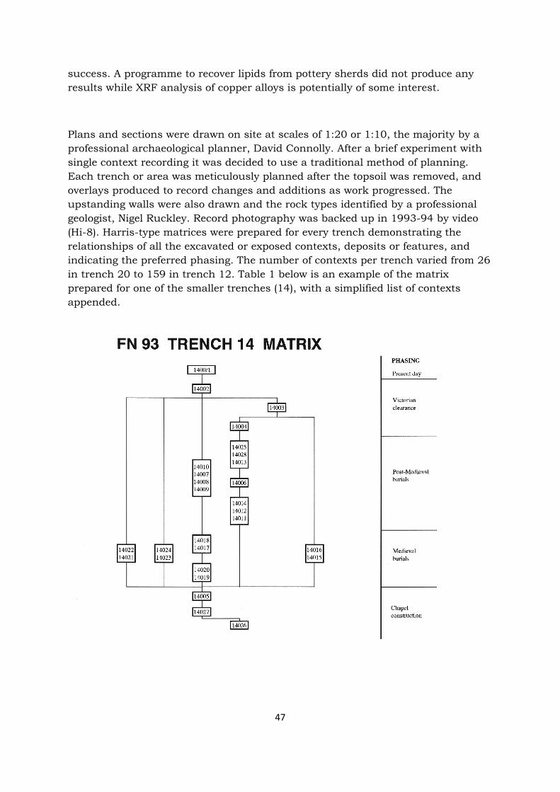
success. A programme to recover lipids from pottery sherds did not produce any results while XRF analysis of copper alloys is potentially of some interest.
Plans and sections were drawn on site at scales of 1:20 or 1:10, the majority by a professional archaeological planner, David Connolly. After a brief experiment with single context recording it was decided to use a traditional method of planning. Each trench or area was meticulously planned after the topsoil was removed, and overlays produced to record changes and additions as work progressed. The upstanding walls were also drawn and the rock types identified by a professional geologist, Nigel Ruckley. Record photography was backed up in 1993-94 by video (Hi-8). Harris-type matrices were prepared for every trench demonstrating the relationships of all the excavated or exposed contexts, deposits or features, and indicating the preferred phasing. The number of contexts per trench varied from 26 in trench 20 to 159 in trench 12. Table 1 below is an example of the matrix prepared for one of the smaller trenches (14), with a simplified list of contexts appended.
47
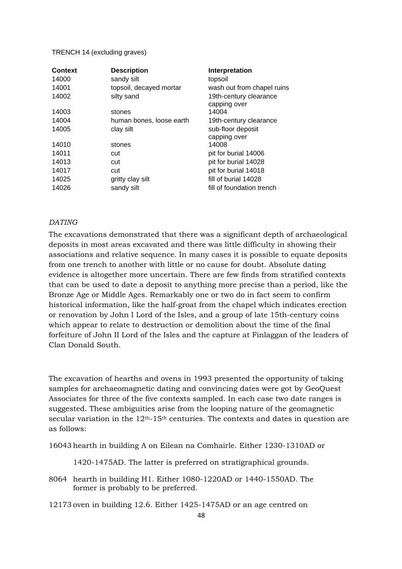
48
TRENCH 14 (excluding graves) Context Description Interpretation 14000 sandy silt topsoil 14001 topsoil, decayed mortar wash out from chapel ruins 14002 silty sand 19th-century clearance
14003 stones capping over 14004
14004 human bones, loose earth 19th-century clearance 14005 clay silt sub-floor deposit
14010 stones capping over 14008
14011 cut pit for burial 14006 14013 cut pit for burial 14028 14017 cut pit for burial 14018 14025 gritty clay silt fill of burial 14028 14026 sandy silt fill of foundation trench
DATING The excavations demonstrated that there was a significant depth of archaeological deposits in most areas excavated and there was little difficulty in showing their associations and relative sequence. In many cases it is possible to equate deposits from one trench to another with little or no cause for doubt. Absolute dating evidence is altogether more uncertain. There are few finds from stratified contexts that can be used to date a deposit to anything more precise than a period, like the Bronze Age or Middle Ages. Remarkably one or two do in fact seem to confirm historical information, like the half-groat from the chapel which indicates erection or renovation by John I Lord of the Isles, and a group of late 15th-century coins which appear to relate to destruction or demolition about the time of the final forfeiture of John II Lord of the Isles and the capture at Finlaggan of the leaders of Clan Donald South.
The excavation of hearths and ovens in 1993 presented the opportunity of taking samples for archaeomagnetic dating and convincing dates were got by GeoQuest Associates for three of the five contexts sampled. In each case two date ranges is suggested. These ambiguities arise from the looping nature of the geomagnetic secular variation in the 12th-15th centuries. The contexts and dates in question are as follows:
16043 hearth in building A on Eilean na Comhairle. Either 1230-1310AD or
1420-1475AD. The latter is preferred on stratigraphical grounds.
8064 hearth in building H1. Either 1080-1220AD or 1440-1550AD. The former is probably to be preferred.
12173 oven in building 12.6. Either 1425-1475AD or an age centred on

49
1290AD. The former date appears more likely on stratigraphic
grounds.
The contexts which failed to produce convincing dates are as follows:
12142 hearth in building 12.3.
12165 oven in building 12.6.
It was considered that the archaeomagnetic vectors from these contexts were either too dispersed or too few in number. The GeoQuest Report is lodged in the Finlaggan Archive.
Radiocarbon dating was carried out sparingly through lack of appropriate organic samples and because most of the deposits they came from were manifestly of medieval or more recent date. Other potential samples, like animal bone from the fill of the chamber on Cnoc Seannda (trench 21) were rejected because there was a significant element of doubt as to whether the original use of the feature was being dated or else some secondary disturbance. In 1999 eight samples for radiocarbon dating were passed to the Scottish Universities Research and Reactor Centre. Three of them were from archaeological contexts, the other five from a sediment core taken in March 1999 in the tip if the alluvial tail of Eilean Mor. The results are as follows: Sample AA-36530(GU-8675) Material human bone: left humerus Context 1050: inhumation in lintel grave in burial ground, Eilean Mor Radiocarbon age BP 1365±50 Calibrated age ranges 1σ cal AD 643-686, cal BP 1307-1264 2σ cal AD 602-771, cal BP 1348-1179 Sample AA–36531(GU-8676) Material wood: alder (worked) Context tr 25 G4017: upper crannog structure, Eilean na Comhairle Radiocarbon age BP 1540±45 Calibrated age ranges 1σ cal AD 434-598, cal BP 1516-1352 2σ cal AD 419-637, cal BP 1531-1313 Sample AA-36532(GU-8677) Material wood: hazel branchwood, 7 years old Context tr 25 G4022: lower crannog structure, Eilean na Comhairle Radiocarbon age BP 2030±45 Calibrated age ranges 1σ cal BC 89-cal AD 46, cal BP 2038-1904 2σ cal BC 168-cal AD 71, cal BP 2117-1879 Sample AA-36533(GU-8678) Material marsh sediment: humic acid dated Sample selection point immediately below unit 10
50
Radiocarbon age BP 11,515±75 Calibrated age ranges 1σ cal BC 11,840-11,461, cal BP 13,790-13,411 2σ cal BC 11,874-11,216, cal BP 13,824-13,166 Sample AA-36534(GU-8679) Material marsh sediment: humic acid dated Sample selection point immediately above unit 10 Radiocarbon age BP 11,305±70 Calibrated age ranges 1σ cal BC 11,475-11,201, cal BP 13,425-13,151 2σ cal BC 11,827-11,071, cal BP 13,777-13,021 Sample AA-36535(GU-8680) Material marsh sediment: humic acid dated Sample selection point unit 7/8 boundary Radiocarbon age BP 9410±65 Calibrated age ranges 1σ cal BC 8781-8608, cal BP 10,731-10,558 2σ cal BC 9108-8479, cal BP 11,058-10,429 Sample AA-36536(GU-8681) Material marsh sediment: humic acid dated Sample selection point unit 7 middle Radiocarbon age BP 7320±55 Calibrated age ranges 1σ cal BC 6228-6082, cal BP 8178-8032 2σ cal BC 6331-6029, cal BP 8281-7979 Sample AA-36537(GU-8682) Material marsh sediment: humic acid dated Sample selection point unit 7/6 boundary Radiocarbon age BP 7795±60 Calibrated age ranges 1σ cal BC 6678-6509, cal BP 8628-8459 2σ cal BC 6797-6467, cal BP 8747-8417 To a limited extent artefacts also provided opportunities for dating the contexts in which they were discovered, but here it is appropriate to sound a note of caution on this process, most easily demonstrable from sherds of wheel-made pottery. There are three cases where well stratified joining sherds come from contexts that are separated by considerable periods of time:
Eilean Mor, trench 7: 3 sherds of a vessel in a reduced gritty fabric (SFs 7096, 7119, 7158). One comes from the turf wall of a house [7.1] that we deduce was erected in the thirteenth century. The other two come from a midden and trampled into a path that were in use in the fifteenth century. Eilean Mor, trench 12: 4 sherds in a reduced gritty fabric (SFs 12072, 12305, 12559, 12570). Two of them come from deposits sealed by the floor of the earliest of a sequence of five houses. This structure [12.4] may be dated to the 13th or 14th century. One of the other sherds is unstratified, but the fourth was recovered from the floor of a building [12.5, part of the kitchens] on the neighbouring plot. It can be demonstrated stratigraphically that 12.5 was build after 12.4 had vanished, probably in the 15th century.

51
That there are any sherds of medieval pottery on Eilean Mor is largely an accidental outcome from innumerable tidying up processes involving all rubbish being removed off the island and dumped in the loch. The examples of joining sherds cited above suggest that many of the sherds excavated on the island may not have been recovered from contexts with which they were associated when the vessels were actually in use. The implications of this for the use of ceramics and small finds in characterising and dating phases of activity on a complex site are considerable.