california department of forestry and …cdfdata.fire.ca.gov/pub/fireplan/fpupload/fpppdf136.pdf ·...
TRANSCRIPT

CALIFORNIA DEPARTMENT OF FORESTRY
AND FIRE PROTECTION
FIRE MANAGEMENT PLAN
San Mateo/Santa Cruz Unit California Northern Region
July 2004
1

TABLE OF CONTENTS page Executive Summary Introduction San Mateo/Santa Cruz Unit Profile 5
General Description of Unit Stakeholders 7 Who They Are What they Deem Necessary General Description of the Current Fire Problem 9 Fuels Ranking 10 Assets at Risk 11 Level of Service 15 Fire Weather 17 Ignition Management Plan 18 Fuel Management Projects 25 Vegetation Management Project Burns 31 Action Plan 34
2

Executive Summary The San Mateo & Santa Cruz Unit’s (CZU) Fire Management Plan is an account of our intentions towards reducing the total financial and emotional costs of wildland fires in these two counties. We develop projects and activities that are designed to protect the community’s assets that are at risk by reviewing existing wildland fuel types and locations, the area’s fire weather history, and fire “starts” and our success at extinguishing those fires using available Initial Attack resources. CDF, local government, community, and concerned industry participants can utilize specific mitigations customized for each identified problem area. Fuel reduction may be the most advantageous technique in some instances; enhanced enforcement of fire clearance ordinances, establishing fuel breaks, or implementing fire resistant construction standards may be most effective in others. The four layers of data used to illustrate and support the goals of this plan are Level of Service; Assets at Risk, Fire History, and Fire Weather History (they are further described later in this document). The process of validating this information is ongoing and will be so as long as vegetation continues to grow and development continues to occur in previously undeveloped wildland areas. CZU Fire Planning staff has identified the following concerns:
• Fire Weather History Layer- Local knowledge of actual weather (wind speed and direction, ambient and surface temperature, and humidity) conditions at fire scenes contradicts the available scientific data obtained from our Remote Automated Weather System (RAWS) sites. Repositioning our La Honda and Corralitos RAWS should result in the reporting of more representative conditions.
• Level of Service Layer (LOS) – CZU Fire Planning and Fire Prevention staff
are combining efforts with the Unit Emergency Command Center to more accurately plot and illustrate the location of fire starts. This part of the LOS layer will be an essential component of the Unit Ignition Management Plan when considering prevention and education efforts.
• Assets at Risk – Further cooperation with County government and local
agencies needs to be applied to the identification of assets process.
Every Battalion in the Unit participates in the implementation of the Unit Fire Management Plan. In most cases, the involvement is centered on the operational and traditional “prevention” activities such as LE38 inspections, community education, and enforcement. CZU Management is working with Pre-Fire Engineering staff to develop enhanced inclusion of field personnel into the development process of the Fire Plan.
CDF staffs, through contract, are the Fire Protection Planners in both
San Mateo and Santa Cruz counties. This function has facilitated the initiation and implementation of Urban/Wildland Interface construction
3

codes in both jurisdictions. The Santa Cruz County Board of Supervisors has completed the public hearing process required for adoption and the same process should occur in San Mateo County prior to the end of this year. With that behind us, staff can focus on issues in conjunction with County general plan issues.
This plan’s development and implementation depends on the continued
fostering of the cooperative effort internally within CZU programs and externally with our public and private partners. The work that we are able to accomplish now will certainly enhance the safety of our communities.
John E. Ferreira, Chief CDF-San Mateo & Santa Cruz Unit
4

The California Department of Forestry and Fire Protection (CDF) and local government fire departments have come to recognize that the expansion and excessive buildup of flammable vegetation within “ wildland urban interface “ has created a potential for devastating loss of life, residential, commercial property and forest resources. The San Mateo & Santa Cruz Unit has developed the Fire Management Plan (FMP) to implement the statewide fire plan at the local level. The overall goal of this plan is to reduce total wildfire costs and losses from wildland fire by protecting assets at risk through focused vegetation management projects and aggressive “Fire Safe Defense Awareness” Programs throughout the San Mateo & Santa Cruz Unit. The major components of the plan include:
Creation of local forums to determine what the fire problem is through input from citizens, community groups, local agencies and other stakeholders.
Identification of assets at risk, enabling the stakeholder forums and the
Unit to set priorities for vegetation management project work. These assets include citizen and firefighter safety, structures, watersheds, wildlife and habitat, timber or unique areas of cultural or historic significance, and air quality.
Development of wildfire protection zones through vegetation management
projects that reduce the risks of large damaging wildland fires.
Development and implementation of vegetation management projects cooperatively with stakeholder forums. Projects may include a combination of mechanical clearing or prescribed fire.
This document is a dynamic working plan that will be reviewed and updated periodically, yet is flexible enough to meet the needs of the Unit. The intent is to keep it simple, easy to understand and, above all, a “guide”. SAN MATEO & SANTA CRUZ UNIT PROFILE The San Mateo & Santa Cruz Unit covers an area of 1000 square miles and protects 426,230 acres of State Responsibility Area (SRA). The Unit’s western boundary is the Pacific Ocean, to the north San Francisco, to the east the San Francisco Bay area, Santa Clara County and to the south the Pajaro River. San Mateo and Santa Cruz Counties lie completely within the Santa Cruz Mountains. The main axis runs in a general northwest – southeast direction. From just south of San Bruno Mountain in San Mateo County to Mt. Madonna in Santa Cruz County, the ridgeline runs about 65 miles and contains the highest point of the range at Loma Prieta (3806 feet). Among the higher peaks are: Mount Umunhum (3442 feet); Castle Rock (3214 feet); Ben Lomond
5

Mountain (2600 feet); Eagle Rock (2488 feet); Kings Mountain (2315 feet) and Mount Madonna (1897 feet). The Santa Cruz Mountains continue to be molded by rapidly evolving interplay of uplift and erosion. This movement has caused water runoff (streams) creating moderate to very steep slopes. The area has numerous seismographic faults that run throughout the range -the San Andreas Fault being the most famous. The frequent earthquakes in the region show that mountain building forces are still at work. Dense conifer stands, typically with a heavy accumulation of litter and downed woody material, dominate the vegetation within the Unit. Coastal scrub communities, consisting of low vegetation up to six feet in height, occur on coastal bluffs, coastal hills and, frequently on wind swept summits. Growth is usually dense and difficult to penetrate. True chaparral communities can be found in isolated areas on southwest aspects throughout the Unit and at higher elevations. Grasslands occupy areas mainly in the coastal valleys, along the eastern slopes of the Santa Cruz Mountain Range, and in the southern end of the unit. The majority of this community has been lost to agriculture or urban development. Approximately one million people reside within the Unit. Another one million + people uses the numerous state, county and city recreational facilities and forested areas annually. Recreational use of public lands is a year round activity and remains in great demand by people from the metropolitan Bay Area. Half a dozen major highways, all of which pass through CDF protected watersheds, traverse both San Mateo and Santa Cruz Counties. These transportation corridors are vital to the state highway system and state commerce. Development and open space (wildland) form a common boundary in both counties. Much of this area is contiguous to State Responsibility Areas (SRA) and the development of rural style living is progressing at a moderate to rapid pace. Where there were once summer cabins on winding, narrow roads there are now yearlong residences, most of which are valued in excess of four hundred thousand dollars with many in the one million to three million dollar range. GENERAL CLIMATE The Santa Cruz Mountains have what may be considered a cool summer Mediterranean climate, characterized by low average summer temperatures and wet winters. Generally speaking, most of the rain occurs between December and March. It is not uncommon to see periods of precipitation begin as early as October and extend into April. Rain may occur in June or July, though that is rare.
6
The average season rainfall total for the lt 5 years: Skylonda 50 inches Corralitos 37 inches Felton 54 inches The above three locations are a good representation of rainfall locations.

During the summer months coastal fog is common and extends inland to the crest of the ridges, often pouring through passes onto the eastern slopes, into the San Francisco Bay Area, and the Santa Clara Valley. Local topographic features prevent fog from reaching some of the higher ridge top areas. As a rule of thumb, the fog normally burns off about midday, allowing for daily temperatures to reach an average of 70 to 85 degrees. Snow occasionally falls on the higher crests and ridges of the mountains usually melting within a day. STAKEHOLDERS Recognizing the need for resources to provide the work on fuel reduction projects within San Mateo County, the San Mateo County Sheriff’s Department, local government and CDF/County Fire developed a working partnership that would provide two "deputy" supervised inmate conservation crews to work on projects. In the fall of 1991, two crews began work on Old Stage Road adjacent to the San Francisco Watershed (Crystal Springs), to provide fire department access below the Highland Subdivision (Bunker Hill area). Originally named the “San Mateo
County Wildland Hazard Task Force”, the founding members included CDF Ranger Unit Chief Dave Mack, Captain John Wells of the San Mateo County Sheriff’s Department and retired Division Chief Steve Richmond. This organization preceded the state’s own Fire Safe Council by three years.
Due to budget challenges, one crew remains funded and their quarters have moved to a Transitional Unit within the San Mateo County Jail. In 2003 Fire Safe Crews worked a total of 24 project days clearing 28 tons of vegetation and protecting property worth 34 million dollars. Fire Safe San Mateo continues to be the driving force behind fuel reduction projects within the county and continues to encourage and support Fire Safe presentations and activities. It has supported community events in Woodside (San Mateo County), La Honda (San Mateo County) July 4th Celebration, and the Half Moon Bay Fire Department’s (San Mateo County) Safety Fair. Other accomplishments include developing a Fire Safe Speaker’s Bureau, a grant program for homeowner groups to reduce hazardous vegetation from around their neighborhoods; working with local fire agencies on press releases, and providing self-help procedures and Fire Safe information for homeowners. As part of its 2004 Goals, Fire Safe San Mateo will actively seek public and private grants to fund Fire Safe projects, seek projects with new agencies or homeowner associations, and provide defensible space demonstrations to homeowner or road associations. Santa Cruz County. Since the dissolution of the Santa Cruz County Fire Safe Council, the idea that a smaller council be established under the auspices of the Santa Cruz County Fire Chiefs’ Association is currently being explored.
7

Several communities within the County have or are in the process of establishing smaller focused community fire safe groups. They are: Las Cumbres Homeowners’ Association, has worked with the Unit off and on over the past 20 years. The residences are located on the south and west slopes of Beatty Ridge above the Bear and Shear Creek drainages. This community has participated in several fuel reduction projects. The residents of Las Cumbres have combined their efforts to organize a community focused fire safe committee addressing wildland fire potential. CDF is working with them to accomplish their goals. The Rural Bonny Doon Homeowners’ Association has approached CDF to assist them in addressing their fire safe needs. The community, located above Felton, is surrounded by stands of Knobcone Pine, scattered Eucalyptus trees, Douglas Fir and stands of chaparral scrub. On one side of the residential area lies the Bonny Doon Ecological Preserve (managed by California Fish and Game). The threat of a disastrous fire could potentially start within this preserve. The area has limited access. Homes in the subdivision can exceed $850,000 dollars in value. The Bonny Doon Community Fire Safe Committee has been organized to plan and support fuel management projects within the community as well as the preserve. The Department of Fish and Game (DFG) maintain the preserve. In a cooperative venture, CDF and DFG are working to develop a Fire Management Plan for the preserve. This plan will address fuel reduction projects and any future vegetation management burns. Additional stakeholders include: Santa Cruz County Resource Conservation District. This public resource agency was created to assist people to protect, conserve and restore natural resources through information, education and technical assistance programs. CDF continues to work cooperatively with the District on several projects. The most current is the Loch Lomond/Zayante Watershed Fuel Management Project. San Mateo County Parks Mid Peninsula Regional Open Space District San Francisco Water Department Peninsula Open Space Trust Santa Cruz County California Department of Parks and Recreation City of Santa Cruz Water Department
8

GENERAL DESCRIPTION OF THE CURRENT FIRE PROBLEM The San Mateo & Santa Cruz Unit has not had a long-standing significant fire history. In the late 1950’s to the mid 1960’s, the Unit experienced a number of large fires, the largest being the Lincoln Hill fire (1962) that consumed over 3000 acres. Since then, fires within the unit have been kept relatively small. The Sunset Fire (Big Basin State Park) burned approximately 32 acres in 1995. In that same year, a late season fire along Highway 35 in San Mateo County consumed 20 acres and a 54-acre fire occurred in October of 2001 along the same corridor. Three significant fires have occurred outside the Unit and by virtue of weather conditions and vegetation types, threatened Santa Cruz County. The Austrian Gulch, Lexington, and Croy Fires started in the Santa Clara Unit and extended into Santa Cruz County. Each fire was a large event, ranging from 3,000 to 13,000 acres in size. The San Mateo & Santa Cruz Unit works cooperatively with Local Government Agencies and the Governor’s Office of Emergency Services. This interagency cooperation is the result of Automatic and Mutual Aid Agreements that were initiated and are maintained by the Unit. These cooperative efforts of the fire service providers result in an integrated fire protection delivery system. The following table illustrates the number of local agency resources that are immediately available to the Unit: San Mateo County
Agency Structural Engines Wildland Engines Half Moon Bay FPD 2 South County FPD 2
Woodside FPD 2 1 Hillsborough FD 1 South City FD 2
Redwood City FD 2 1 Palo Alto FD 2 1
Menlo Park FD 1 1 Santa Cruz County
Agency Structural Engines Wildland Engines Aptos La Selva FPD 3 1 Ben Lomond FPD 2
Boulder Creek FPD 2 1 Branciforte FPD 1 1
Central FPD 4 1 Felton FPD 2
Santa Cruz City FD 3 Scotts Valley FPD 2 1
UCSC FD 1 Watsonville FD 2 1 Zayante FPD 1 1
9

FUELS RANKING The various fuels found in the San Mateo & Santa Cruz Unit are categorized into models each of which has specific burning characteristics. These models along with slope class, ladder fuel, crown closure component, and difficulty of control rating was used to derive the fuel hazard ranking for each Quad 81st. For the purpose of ranking potential impacts for a given Asset At Risk (AAR), a common statewide geographic unit was developed. Using the USGS 7.5 topographical quadrant map, each quad map was divided into grid cells, about 450 acres each. Each map yields 81 cells; thus in the fire planning process the term Quad 81st is applied. The fuels in the Unit have been ranked Very High, High, and Moderate. A fine-grained portrayal of surface fuel conditions was developed using the most recent and up to date vegetation and structure information. Commencing in April 2004, Unit vegetation coverage data began to be updated on a statewide basis. San Mateo & Santa Cruz Unit’s vegetation data layer is nearing completion. A second map layer is added to reflect surface fuel changes caused by recent fires and subsequent re-growth. This can help portray expected post-wildfire fuel conditions based on the pre-fire fuel vegetation layer and elapsed time since a fire occurred. Ladder and crown fuels are determined by the relative abundance of fuels. Values range from “absent or lacking fuels” to “present but spatially limited” then to “widespread”. The higher value implies a greater probability that torching and crown fires would occur if the stand were subjected to a wildfire under severe fire weather conditions. The result information is the basis of the following Unit Vegetation Map.
10

11

ASSETS AT RISK (AAR) The Assets at Risk (AAR) in the San Mateo & Santa Cruz Unit are the public (communications infrastructure, water systems, facilities) and private assets (homes, outbuildings, vehicles) that the fire protection system has been created and funded to protect. This plan identifies the following assets at risk from wildfires, and delineates their economic and non-economic value: air quality, structures, timber, water and watersheds, wildlife and habitat, recreation, range, cultural, historic and scenic. Using Geographical Information System (GIS) data, overlays of each asset are made onto a map. This result is a vivid depiction of the location of individual and collective assets that have been identified by Unit Pre-Fire Engineering, the Vegetation Management Bureau, the Fire Prevention and Planning Bureau, Unit Operations and Management Staff, and community stakeholders. Relative rankings of High, Medium and Low values are made for each asset, Assets at Risk: Structures The overall ranking of structures at risk, is a combination of two factors, value of housing (as measured by housing density) and susceptibility of loss (exposure). Exposure is defined as the likelihood of structures being destroyed or damaged in a large fire. Together, density and exposure provide a measure of overall loss potential. Exposure is assumed to be High for all Quad 81st cells with vegetative fuels. If Quad 81st cells are primarily not wildland fuels (water, dense urban or agriculture), they are given an exposure of zero. Exposure incorporates numerous site-specific factors in the populated portion of the Quad 81st cell. The factors considered and how they are weighted in determining overall exposure will vary by Unit and even within a Unit. The following is a list of factors that can contribute to exposure: Building materials Accessibility of fire suppression resources to housing locations Slope conditions affecting housing Vegetative clearance around structures Presence and timing of past or present fuel management projects The AAR continues to undergo stakeholder review and is subject to change over the course of time.
12

SAN MATEO & SANTA CRUZ UNIT ASSETS AT RISK
13

SAN MATEO & SANTA CRUZ UNIT STRUCTURE ASSETS AT RISK
14

LEVEL OF WILDLAND PROTECTION SERVICES (LOS) The Level of Service (LOS) rating is a method that measures initial attack suppression success and failure rates throughout California wildlands. The LOS is determined by using the number of fires (size and intensity), vegetation type, and weather over a 10-year period. Fire activity is updated on a continuing basis through the Emergency Activity Reporting System. The data is electronically passed on to the Emergency Command System. This data is then stored at the CDF Headquarters in Sacramento. Success (and Failure) Calculation:
SUCCESS RATE =
Annual number of fires that were small and extinguished by initial attack Total number of fires
SUCCESS RATE = X percent
This results in an initial attack success rate expressed in percentage of fires by vegetation type and by area. The San Mateo & Santa Cruz Unit uses 4 vegetation types (brush, coastal and interior conifer, and grass) for calculation purposes. The following chart gives you the Unit’s Success Rate over the past 10 years: the data was compiled via EARS and the Unit is actively verifying its accuracy.
Vegetation Type Number of Fires (past 10 years) % Success Spot Small Medium Large Brush 16 2 1 1 90 Coastal Conifer 908 32 33 9 98 Interior Conifer 117 11 10 1 94 Grass 25 2 3 90 Acreage definition: Spot: Less than acre Small: 1 – 2 acres Medium: 2 – 10 acres Large: 10 – 100 acres The following graphic displays location of vegetation fires in the Unit for 2003. Fires are overlaid on two types of data: the Fire Hazard Severity and Population Density for the Unit.
15
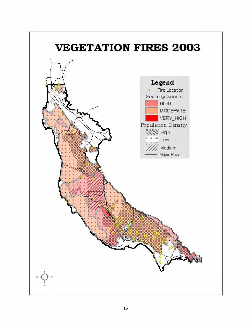
16 16

FIRE WEATHER The Central Coast has a Mediterranean climate characterized by long, dry hot summers and wet winters. Winter rainfall can exceed 60 inches. The San Mateo-Santa Cruz Unit sits along the San Mateo coastline and extends along the northern half of the Monterey Bay. Commonly referred to as the “sunny side” of the bay, summertime temperatures range from 60 to 70 degrees along the coast, to 80 plus degrees in the interior portions. Inland valleys frequently exceed 90 degrees. The Unit Climate Class Description (from the National Fire Danger Rating System) was changed in 1999 and cataloged as a Climate class 3 along the Coastal Zones. Interior Zones were classified as Climate Class 2. Three Fire Danger Rating Areas are used to determine the fire danger within the unit. These areas exhibit significant differences.
San Mateo Coast (Zone 1): Affected by westerly breezes and fog as the result of an inland convection pattern that draws cool air off the coast during most summer days. Higher elevations in these areas are included in Zone 3. Santa Cruz Coast (Zone 2): The south boundary of San Mateo County to the north boundary of Monterey County, this zone extends inland to the lower elevations and is affected by fog and coastal breeze intrusion. Inland Valleys and Ridges (Zone 3): This area includes the upper elevations and inland valleys not so greatly influenced by coastal moisture and far more influenced from inland warming and lower humidity’s. Frequent temperature inversions will influence this zone.
Winds are generally from the North to South West creating light summer upslope winds from mid morning to late afternoon depending on ones location. The sea breeze system is a general occurrence along the upper coastal slopes. Depending on the current yearly weather pattern, off shore or East winds may occur as early as May and then reappear through the summer months in mini-intervals commencing with larger windows of opportunity in September and October. Analysis of statewide Fire Weather has been an ongoing project. Unit discussion has led to exploring the possibility of repositioning the following RAWS sites to a more favorable and representative location: La Honda to an upper slope placement in La Honda Corralitos to the Pajaro Valley Fire Station
17

IGNITION MANAGEMENT PLAN The Fire Prevention Bureau’s primary mission relative to the Unit’s Fire Management Plan is to reduce and hopefully eliminate the ignition of unwanted fires. Additional measures are taken to reduce flammable fuels adjacent to structures and other improvements for the purpose of preventing fire spread both to, and from these improvements. Through sound engineering practices, plans for new construction and modifications are developed with fire and life safety as a primary consideration. IGNITION MANAGEMENT GOAL “To develop and implement a fire prevention plan which will establish specific objectives to reduce the ignition of unwanted fires of all types throughout the San Mateo / Santa Cruz Unit” The natural and human produced conditions existing in the San Mateo / Santa Cruz Ranger Unit dictate that an aggressive fire prevention plan be initiated to reduce the probability of ignition of any fire that may threaten life, property, natural resources or the environment. This ignition reduction plan must be applied as an all areas, all assets, all fire types endeavor. Through planning, implementation and control, the Ignition Management Plan addresses each of the Fire Prevention Elements of Information, Education, Engineering and Enforcement. The plan utilizes paid staff as well as participants in the Volunteers In Prevention (VIP) Program to accomplish specific fire prevention objectives. These objectives are developed through the analysis of fire statistics from previous years and through an assessment of fire potential in each of the six geographic battalions. FIRE PREVENTION BUREAU The Unit Fire Prevention staff consists of the Fire Prevention Bureau Chief, one Fire Captain Specialist and one Fire Prevention Specialist I (currently unfilled). The San Mateo County Fire Protection Planning Section includes one Battalion Chief and one Fire Captain Specialist that report. The Santa Cruz County Fire Protection Planning Section consists of two Fire Captain Specialist and two Fire Prevention Specialist IIs. IGNITION MANAGEMENT OBJECTIVES INFORMATION Public awareness of the fire problems that exist in the Unit and measures that can be taken by citizens and visitors to reduce the chances of fire occurrence of any type will be enhanced by the following methods: • The release of Public Service Announcements (PSA) through all available
media sources. These PSAs will address seasonal fire and life safety
18
concerns such as spring fire hazard reduction, campfire regulations, home heating safety, use of spark and heat generating equipment, home smoke detectors, etc.
• The periodic distribution of press releases to all media sources detailing
current fire hazard conditions, planned events and Department status and response readiness. These releases include information on the implementation of the annual fire hazard inspection program, the beginning of declared fire season, peak season and end of season.
• The release of special bulletins during periods of extreme fire hazard, burn
permits suspensions, declarations of hazardous fire areas and information regarding the enforcement of the forest and fire laws.
• The posting of roadside and trailhead fire prevention signs. EDUCATION While the Information element serves to notify and increase public awareness of the fire problem, additional measures must be taken to target specific groups and activities and to provide a more focused approach to educating the targeted audience to the dangers and the prevention of fires. The following measures are taken to expand the Unit’s Education element: • Develop, schedule and implement a proactive elementary school Team
Teaching program that will provide fire prevention education to the elementary schools in the Unit. This program requires the participation of the paid and volunteer fire companies and the Volunteers In Prevention as well as the Fire Prevention Staff.
• Establish and implement an annual elementary school fire prevention poster
contest. • Participate in the county fairs, local parades and special events such as
public safety exhibits. • Provide fire and life safety programs and demonstrations as requested by
community service groups and governmental agencies and their employees. • Develop Community Emergency Response Teams with cooperation with
other local government fire agencies. • Encourage CERT members to become involved in Volunteers in Prevention
program. • Expand the department’s involvement in the state and county parks
recreational programs as an opportunity to project the fire prevention message.
19
• Explore the possibilities of conducting fire prevention education programs on the local public access television stations.
• Be a leading participate in local San Mateo Fire Safe Council. ENGINEERING The Engineering component of the plan involves all areas within the Unit’s jurisdiction. Fire Safe engineering practices must be maintained in both SRA and LRA under CDF protection. • Continue construction plan review and site inspections to insure compliance
with the state and county fire, life safety and building requirements (PRC 4290, County Ordinances, etc.).
• Continue the hazard inspection program to insure compliance with PRC
4291. This program requires the designation of target areas and minimum inspection performance levels within each of the Unit’s six (6) field Battalions.
• Both San Mateo and Santa Cruz Planning sections continue to work towards
County adoption of Wildland Urban Intermix Code (WUIC). • San Mateo Planning section continue to work on adoption of the 2003
Building and Fire Codes • Conduct annual pre-fire season fire prevention meetings with cooperators
and allied agencies such as Pacific Gas and Electric Company, Roaring Camp and Big Trees Railroad, County Parks and Recreation Departments, CalTrans, Mid Peninsula Open Space and the California Department of Parks and Recreation.
ENFORCEMENT • Conduct a complete investigation to determine the origin and cause of each
fire occurring within the Unit’s jurisdiction. • Pursue the collection of suppression costs on all fires determined to be the
result of negligence or a violation of the law. • Continue the practice that enforcement action be taken on all incidents that
are determined to be the result of negligence or a violation of the law. Require that the responsible officer in instances submit an in-lieu letter where enforcement action was not initiated.
• Explore the possibility and practicability of certifying all Battalion Chiefs
(staff and field) as Public Officers as provided in the Public Resources Code. • Develop working relations with other local law enforcement agencies.
20

• Participate with Santa Cruz County Arson Task Force and San Mateo Arson
Investigators Unit. VOLUNTEERS IN PREVENTION This program utilizes interested VIPs in the fire prevention elements of Information and Education. • Continue the Unit-wide campaign to recruit program volunteers. • Continue the formulation and implementation of the program to utilize VIPs
to assist in the application of the Information and Education components of the Unit Ignition Management Plan.
• Coordinate a LE-38 training program with local Fire Station staff.
2004 SAN MATEO & SANTA CRUZ UNIT BATTALION PREVENTION IGNITION OBJECTIVES
Battalion 1 Overview Battalion 1 is located in the northern section of SM/SC Unit. The city and county of San Francisco to the north, the Pacific ocean and the cities of Daily City, Pacifica and Half Moon Bay to the west. Highway 280 along with the cities of San Carlos, Redwood City, Woodside, Menlo Park and Palo Alto generally make up the east boundary. Battalion 1 continues south to the Santa Clara County line. Battalion 1 consists of Belmont FS (Station 17) and Cordilleras FS (Station 18). Objectives
1. LE-38 inspections and hazard reductions in the San Francisco water sheds.
2. Weed abatement in LRA of South County area. 3. Hazard fuel reduction in island of SRA within San
Francisco city. 4. Fire Hazard posters 5. Work with CalTrans on fuel modification along Highway
280.
21

Battalion 2 Overview Battalion 2 follows the Ward Truck trail west to the Haul Cutoff and on to the Gazos Creek truck trail to the San Mateo County line. The Pacific Ocean is the boundary to the west. The south boundary runs from the coast up Last Chance Road to Big Basin State Park, Highway 236 to Highway 9 to Bear Creek and then up to Summit Road. The east edge follows Summit Road and Highway 35 north along San Mateo County line. Battalion 12 consists of Saratoga FS, Jamison FS, Las Cumbres Volunteers and South Skyline Volunteers. Objectives:
1. Inspect burn sites prior to burning to reduce debris burn escape incidents.
2. LE-38 inspections of the Castle Rock area. Continue to support Las Cumbres VIPs and their LE-38 inspection program.
3. Power line inspections to reduce power line caused fires. 4. Install and monitor Roadside signs located at Saratoga FS,
Highway 35 and Skyline. 5. Continue school education programs with Boy Scout Camp, Camp
Hammer and Boulder Creek. Battalion 3 Overview: Battalion 3 boundaries generally follow Highway 236 to Highway 9 to Bear Creek Road to Skyline, east to Highway 17 to Glenwood and over to Branciforte Ave. The south boundary is the city limits of Santa Cruz and west to the Pacific Ocean and San Mateo County line Battalion has responsibility for Felton FS, Big Creek FS, Davenport Volunteers, Bonny Doon Volunteers and Ben Lomond Camp. Objectives:
1. LE-38 inspections with a goal of 15 inspections per company per month throughout fire season.
2. Develop Fire Management plan for Bonny Doon Ecological Reserve.
3. Update hydrant location map, measure flow and mark hydrants. Clear and map Fall Creek and Waranella Truck Trails, update necessary property agreements.
4. Update preplans and record any new target hazards.
22

Battalion 4 Located in the area south of Santa Cruz City to the Pajaro River. Stretching from the Monterey County line, east along the City of Watsonville to the Santa Clara County line and along the summit west through the Soquel Demonstration Forest. The Battalion contains heavy timber on steep slopes turning to mixed brush with grass; lands in the foothills and valleys. Special features include the Soquel Demonstration State Forest and the Forest of Nicene of Marks, numerous State and County Beaches, two high schools, portions of Highway 1, and a growing intermix challenge. Objectives:
1. Inspections of burn piles/areas and public education during permit issuance.
2. LE-38 inspections. 3. Power line inspection. 4. Complete reports and inform Fire Prevention on Cost
Recovery incidents. 5. Public awareness/education of fire danger in State Park
during open Public Access days. Battalion 5 Located in southwest San Mateo County. Its boundaries on the east from Skyline corridor/Crystal Springs Reservoir, to the wets is the Pacific Ocean, and the northern boundary runs along Highway 92,and the southern boundary is the San Cruz County line. Within the Battalion are the communities of La Honda, Pescadero, Kings Mountain, Loma Mar and Middleton Tract. There are no incorporated cities. The Battalion is predominantly open space and rural residential. There several parks; Butano, San Gregorio, Pomponio, Bean Hollow, Ano Nuevo and Portola State Parks; Memorial, Pescadero, Huddart and Sam MacDonald County Parks. Vegetative cover along Skyline is predominately redwood forest changing to brush and hardwoods to grasslands down to the Pacific Ocean. Objectives:
1. Fire inspection and public education for burning permit, inspection of burn sites.
2. LE-38 inspection, 200 inspection per station, Pescadero will target Pescadero Road from Beach to Horse Camp (118 homes), all of Loma Mar (14 homes), all of Wurr Road (46 homes), Cloverdale Road (24 homes.
3. School education, make contact with local schools, parks and operators of local events and continue education programs.
4. Public presence at public events, two-day motorcycle event, two-day Pumpkin Festival in Half Moon Bay and two-day rodeo in La Honda.
5. Battalion Chief Biscay will attend Pescadero Municipal Advisory Committee and San Mateo County Fire Safe Meetings.
23

SAN MATEO & SANTA CRUZ UNIT FIRE CAUSE Fire Cause * Pre 2000, 5yr avg. 2001 2002 2003 3 year Average 2003 SRA Veg. CauseAccident (vehicle) 6 11 3 6.7 1 Arson (Vehicle) 14 16 23 17.7 3 Arson (Structure) *16.0 0 1 3 1.3 Arson (wildland) 15 10 9 11.3 5 Barbeque 5 0 4 3.0 2 Bonfire 4 0 1 1.7 Cad. Converter 1 0 3 1.3 2 Campfire *11.4 20 17 12 16.3 7 Candle 1 3 2 2.0 Children *7.8 4 5 7 5.3 4 Chimney 10 15 11 12.0 1 Cigarette 12 6 9 9.0 3 Control Burn *18 12 6 8 8.7 7 Cooking Fire 4 0 1 1.7 Dryer 1 3 1 1.7 Electrical (Structure) 54 53 16 41.0 Electrical (Veg.) *46.2 **na **na 13 13.0 3 Electrical (Vehicle) **na **na 10 10.0 Fireworks 10 5 6 7.0 6 Flare 1 0 1 0.7 1 Fuel Line (Vehicle) 14 14 10 12.7 2 Gas (prop./nat. gas) 3 4 5 4.0 Hot Ashes 9 9 9 9.0 4 Hot Oil 7 5 0 4.0 Illegal Burn 18 24 24 22.0 14 Lighting/Lamp 11 0 3 4.7 Lighter (juvenile) 0 0 1 0.3 Lightning 10 2 1 4.3 1 Matches 5 1 3 3.0 Mechanical Malf. *12.6 8 6 6 6.7 2 Mower 0 2 2 1.3 4 Powerlines 2 1 4 2.3 2 Powerlines (veg fire) 0 0 9 3.0 9 Smoke Bombs 0 2 1 1.0 1 Smoking *8.2 0 0 1 0.3 Spontaneous Comb. 6 3 1 3.3 Stove (propane) 7 12 1 6.7 Stove (wood) 3 0 8 3.7 2 Undetermined (veh) 3 2 5 3.3 Undetermined (str) *25.8 18 26 3 15.7 Vehicle Exhaust 7 2 4 4.3 5 Water Heater 1 2 3 2.0 Welding 2 0 1 1.0
TOTAL 308 268 248 290.0 91 * Prior to 2001 only 12 fire causes where recorded, Child/Matches, Campfire, Debris Escape, Electrical, Equipment Use, Miscellaneous, False Alarms, Agency Assist, Smoking, Undetermined, Missing, Arson
24
FUEL MANAGEMENT PROJECTS Fuel Management involves changing the amount, kind and arrangement of both natural vegetation and human constructed fuels. Unit Fire Risk Zones are defined as areas of high assets at risk, fuel loading in excess of 4 tons per acre (using the predominant fuel model of dense conifer stands) and weather patterns that include higher than normal temperatures and lower humidity (Zone 3). Ignitions or fire starts in these areas may not be excessive. Likely ignitions would start near roads or from equipment use within residential property. The majority of these starts would be contained within the area of origin taking into account the high Level of Service within the unit. Unfortunately, the potential for severe fire weather does exist in the Unit (2 to 5% of the total days monitored during fire season). Control of wildland fire ignitions under these conditions is dependent on detection, emergency response time, hazard abatement measures and fire suppression strategies. Focusing on the potential unit fire threats (referred to as Fire Risk Zones), these zones are: Indian Trails Subdivision La Cumbres Subdivision Bonny Doon Ecological Preserve Pineridge Subdivision Lompico/Zayante Watersheds Several fuel modification treatments have been effectively implemented within the Unit. They are:
Manual vegetation removal. Less disruptive to the environment then mechanized treatment, this includes limbing/pruning or removal of all dead or live vegetative growth up to eight (8) feet from the ground on mature shrubs or trees, usually to separate the aerial array of fuels from ground and/or “ladder fuels”. This technique is utilized to break the vertical continuity of a fuel bed and decrease the susceptibility of taller trees and shrubs to a wildland fire event. The use of “thinning” the vegetation is another desired treatment. Thinning includes the selective removal of shrubs and or other material to break the horizontal continuity of a fuel bed, decreasing the overall burning intensity of the fire event.
Chipping. Chipping is an effective method to reduce the green waste (biomass) from a manual vegetation treatment. Chips can be scattered on site and is environmentally safe.
25
Santa Cruz County Fire Chiefs’ Association has purchased a chipper for the sole purpose of fuel management projects. The purpose of the Chipper Program is to assist homeowner or road association members with their neighborhood defensible space projects. In combination with other vegetation management techniques, manual removal methods may be used in sensitive areas and is cost effective. Mechanical vegetation removal. Mechanical removal of vegetation may be used alone or in conjunction with other methods. Mechanical methods of fuel modification are typically more cost effective and less labor intensive than manual methods, but create a higher risk of adverse or disruptive environmental effects such as soil compaction, erosion and damage to sensitive vegetation. Use of mechanical fuel modification are often more practical for cost effective large-scale projects. Mechanical includes tractors, bulldozers or any other heavy equipment. Prescribed burning. The use of this treatment method is an effective management tool that reduces the potential impacts of wildland fire events. This tool can also be utilized to promote the establishment of native grasslands, improve wildlife habitat and increase the age class and diversity of specific plant communities. Prescribed burning offers low cost treatment per acre. As with any fuel management treatment, the use of one specific method over another must be weighed depending on the type of project and location. Use of fire in close proximity to homes in the interface may not be the best choice. A manual treatment may be the better method.
The following Fuel Management Projects are being undertaken in the following geographical areas: San Bruno Mountain Park (San Mateo County) This fuel management project, located north of the Park’s main parking lot off of the Guadalupe Parkway, consists of thinning and removing a stand of overgrown Eucalyptus trees. Presently, talks are under way for project scheduling and funding. Laurelwood Park (Sugarloaf Homeowners’ Association - San Mateo County) The Laurelwood residences have just completed a community master plan. A key component to the plan was fire protection. The plan, currently being discussed with Belmont City Park and Fire Safe San Mateo staff, is to widen and reestablish a shaded fuel break around the residential properties. In 1993, a shaded fuel break was constructed in the same location.
26
Crystal Springs Watershed (San Francisco Water Department - San Mateo County) This ongoing fuel management project includes the South Firebreak (lands located between Canada’ Road in Woodside up the slopes along the PG & E Right of Way to Skyline Boulevard), power pole and fire road access point fuel reduction. Mills Canyon (San Mateo County – Burlingame) This ongoing project consists of maintaining a 30 foot shaded fuel break around the upper end of the canyon and under the residential property lines. Future funding to keep this a continuing project is being explored. Loop Trail Fire Break (Wunderlich County Park – San Mateo County) The project goal is to reduce the Eucalyptus slash and reestablish a shaded fuel break along the Loop Fire Break Trail. The existing road extends 3 miles up slope to the Loop Meadow. The meadow’s overgrown vegetation will be removed, clearing the area that was once a well-established trailhead and picnic ground. Implementation of this project will protect numerous residences along Bear Creek Road, an upscale community in Woodside. Fire Safe San Mateo and San Mateo County Parks applied for funding through a grant. Las Cumbres (Santa Cruz County) The Las Cumbres property owners have worked with the Unit off and on over the past 20 years. This group has identified a need to upgrade the fire roads and fire defense infrastructure within their community. Implementation of this project will protect approximately 1400 acres and 140 homes. The project, upon completion, will reduce hazardous fuel levels to acceptable levels and to improve the fire defense system within and surrounding Las cumbers. This will include a shaded fuel break along 5 miles of roads, reopening of select interior roads and do repair where needed. Bonny Doon Ecological Preserve/Pineridge Subdivision (Santa Cruz County) The Bonny Doon Ecological Preserve (BDEP) is owned and managed by the California Department of Fish and Game. The property is surrounded by residential development with an average resell value of about $800,000 each. The fuel loading within the property is very high due to the age of the knob cone pine, ponderosa pine and manzanita. The area to be protected is approximately 1000 acres.
27

The fire defense system within and surrounding the property needs to be improved by reducing the amount of down and ladder fuels. The Rural Bonny Doon Homeowners’ Association has expressed their concern about the fire hazard in the area and is currently participating in the effort to develop a Fire Management Plan for the BDEP and community. The California Department of Fish and Game, US Fish and Wildlife Service and California Department of Forestry and Fire Protection are working cooperatively, with CDF as the lead, in the implementation of the fuels reduction and fire defense improvements in the area. The goal is to reduce the hazardous fuel levels to acceptable levels and to improve the fire defense system within and surrounding the BDEP. Along with the development of a Fire/Vegetation Management Plan for the preserve, shaded fuel breaks will be developed along several key area roads and upgrade the fire defense roads within the BDEP. Long-range plans for small vegetation management burns are being explored. Indian Trails Subdivision (Santa Cruz County) Located at the headwaters of the San Lorenzo River (San Lorenzo Watershed), the Indian Rock Community has been identified as an area at high risk for a damaging wildfire and a high priority for the implementation of a vegetation management project. The watershed is a major water source for the City of Santa Cruz and surrounding communities. The area that will be protected by the implementation of a vegetation management project is approximately 400 acres. The goal is to reduce the hazardous fuel levels to acceptable levels and to improve the fire defense system within and surrounding the Indian Rock Subdivision. Shaded fuel breaks will be created along 5 miles of interior roads through thinning of fuels, eliminating ladder fuels, chipping and broadcasting the green waste. Pile burning will be used as needed and usable firewood made available to senior citizens within the subdivision. Lompico/Zayante Watershed (Santa Cruz County) This project is a cooperative effort with the Santa Cruz County Resource Conservation District, City of Santa Cruz and the California Department of Forestry and Fire Protection. The goal is to restore the shaded fuel break along the eastern boundary of the Loch Lomond Watershed (Lompico), along the western boundary (of the watershed (Boulder Creek) and within the interior fire defense roads. The Loch Lomond Watershed provides water for the City of Santa Cruz, the communities of Lompico and Zayante. It is a well-known recreational area for the local residents.
28

UNIT FUEL MANAGEMENT PROJECT LOCATIONS
29

2004 CZU VMP PROJECTS Cloverdale Ranch – RX North-017 CZU This VMP is for 2 units covering approximately 150 acres. The Peninsula Open Space Trust (POST) owns the property. Historically the property has been intensively grazed and cultivated for cereal crops. POST is working to restore the native ecosystem on the ranch and prescribed fire is one of the tools that have proven successful. The first unit under this VMP was burned during the fall of 2002 and the second unit will be burned during the fall of 2003. Hill 18 – RX North-018 CZU This VMP covers 3 individual burn units on the San Francisco Water Department properties. The areas will be treated with a combination of mechanical treatment and fire. These burns were planned as part of the San Francisco Watershed’s Vegetation Management Plan. The sites were chosen to provide firebreaks and reduce the fuel load in key areas near urban boundaries and to maintain biological diversity in the watershed. Russian Ridge – RX North-020 CZU This is a 75-acre VMP burn on Russian Ridge along Skyline Boulevard in San Mateo County. The property is owned by the Mid-Peninsula Regional Open Space District and is part of the District’s property wide fire protection plan. Past burning on this property has proven to be very beneficial in the effort to restore native vegetation in this upper coastal terrace prairie. With the town of Los Altos directly to the east of the burn site, fire protection benefits cannot be overstated. The creation of an effective east/west firebreak along this ridge has already proven to mitigate the potential fire hazard in the area. A wildfire in 2001 below a past, adjacent VMP burn provided a safe site for successfully fighting the wildfire. Juncus Tank Ravine – RX North-021 CZU This VMP burn is for 65 acres of grass and brush on San Bruno Mountain. The area is on the Colma side of the mountain. This burn will reduce the fire hazard of the area and assist in resorting native vegetation to the area. Special mitigations will be implemented to protect the endangered butterflies and their host plants. Tremendous coordination among the surrounding fire agencies as well as the Bay Area Air Quality Management District are key to the success of the burns on San Bruno Mountain due to the high population areas surrounding the mountain and the proximity to the San Francisco International Airport. Star Creek Ranch – RX North-022 CZU This VMP burn is for 40 acres of brush in the southern part of the San Mateo-Santa Cruz Unit. The property is privately owned. The brush is to be tractor crushed by CDF and burned after the brush has cured. After treatment the area will serve as an effective fuel break along a main east/west ridgeline. The re-introduction of fire to this coastal sagebrush ecosystem will help to control invasive species and increase native species.
30

Big Basin State Park – RX North-023 CZU This VMP is for 4 burn units on 1680 acres in Big Basin State Park. This VMP was prepared in cooperation with the California Department of Parks and Recreation. The planned burns are part of the parks’ long-standing burning program. The first burn was accomplished during the fall of 2002 on 125 acres. All the burns in the park generally occur after the fi4rst rains of the fall and create challenges for the unit to provide resources at the end of fire season. Wax Myrtle Ravine – RX North-024 CZU This VMP burn is for 7 acres of heavy slash located within the San Bruno Mountain State and County Park in South San Francisco. San Bruno Mountain is State Responsibility Area situated on the San Francisco Peninsula with surrounding fire jurisdictions of South San Francisco Fire Department, San Francisco Fire Department, San Bruno Fire Department, Daly City fire Department, Brisbane Fire Department and Colma Fire Protection District. Special considerations for planning this burn were given for the endangered butterflies that inhabit San Bruno Mountain. The burn will reduce the fire hazard along a major road (the Guadalupe Canyon Parkway) and will be one important step to restore native vegetation and expand the habitat for the endangered butterflies on the mountain. Wilder Ranch State Park – RX North-025 CZU The Wilder Ranch VMP covers 4 burn units comprising 1147 acres. This VMP was prepared in cooperation with the California Department of Parks and Recreation. The major goals of the burns in the park are to reduce the fire hazard in the park, reintroduce fire into the ecosystem that has evolved with fire and to promote native species. The first unit was burned in June 2003 and covered 300 acres. Several neighboring fire departments participated with CDF and DPR in the burn including Santa Cruz Central Fire, Mid Peninsula Regional Open Space District and UCSC Fire Department. We plan on accomplishing the 3 other burn units over the next 2 years.
31

SAN MATEO & SANTA CRUZ VEGETATION MANAGEMENT PRESCRIBED BURN LOCATIONS
32

ACTION PLAN Unit Operations, Program staff and existing stakeholders continue to explore, develop and implement fuel management projects within those geographical areas with the potential of a disastrous wildfire. The projects listed below are either ongoing, in the planning stage or are waiting funding. The Las Cumbres, Indian Trails and Bonny Doon Ecological Preserve/Pineridge Subdivision have been funded by a grant from the US Fish and Wildlife Service through the National Fire Plan. Lack of Ben Lomond YCC fire Crew strength has pushed the completion date for the Las Cumbres and Indian Trails projects to spring of 2005. Alternative crew work is being explored through the State Contract process. The Bonny Doon Project is moving forward with a Fuels Management Plan cooperatively written by the California State Fish and Game, an ad hoc group from the Bonny Doon Community Fire Safe Committee, Unit Vegetation Management and PreFire staff as well as the local Battalion Chief. The plan is to be completed by fall of 2004 with actual groundwork beginning in summer of 2005. The Santa Cruz County Habitat Conservation Plan (HCP)/Critical Fire Hazard GIS Layer Development is near completion. This first phase of the HCP was funded by a grant through CDF. Project goals were to identify those critical fire hazards within the Wildland Urban Interface areas of the county. The resulting product would assist county planning staff in developing “Best Management Practices” for use in critical fire hazard areas that have endangered species or are listed as a sensitive habitat. The San Mateo County Parks/San Bruno Mountain Park Habitat Conservation Plan (Fire Management Plan) is currently being updated with staff from San Mateo County, Thomas Reid and Associates (San Mateo County contractors) and Unit Vegetation Management and PreFire personnel. The project is a portion of the HCP in need of revision. It includes a comprehensive matrix that identifies management units within the Park boundary and how to best manage the overgrown and invasive vegetation. Release of the final product will be in no later than September 2004. Santa Cruz County Urban Wildland Interface Codes On April 10, 2003, the Fire Chiefs Association of Santa Cruz County directed its Fire Prevention Officers Section (“FPOs”) to prepare an urban-wildland interface (“UWI”) code adoption position paper. The FPOs responded by inviting all agencies in the FPO group to participate in a subcommittee that would conduct a study and develop recommendations for the position paper. The following agencies participated in the subcommittee discussions: Aptos-La Selva Fire Protection District, Zayante Fire Protection District, the California Department
33

of Forestry and Fire Protection, Santa Cruz County Fire Department, Santa Cruz County Planning Department, Central Fire Protection District, and Scotts Valley Fire Protection District. The subcommittee was able to reach a consensus on the general recommendations to the Fire Chief’s Association. This paper provides those recommendations and sets forth the attendant pros and cons discussed throughout the consensus-reaching process. The process involved exploring four core UWI components (emergency access, water supply, defensible space, and ignition resistant building materials), two collateral implementation issues (hazard assessment and threshold for compliance), and a sunset provision. The resulting recommendation for each of these seven elements is summarized below.
Emergency Access: make no changes.
Water Supply: increase storage requirement from 4,000 to 10,000 gallons with a provision for offsets to this standard through enhancements of other core components and specify private hydrant requirements.
Defensible Space: make no changes.
Ignition Resistant Materials: adopt UWIC sections 504-506, imposing IR-2 construction as the default.
Hazard Assessment: impose the heightened water and ignition
resistant requirements on homes in specified areas, utilizing the SRA map layer with amendments by individual jurisdictions.
Threshold for Compliance: impose the heightened water and ignition
resistant requirements on new single-family dwellings and on residential remodels that qualify as “replacement construction.”
Sunset Provision: include an automatic sunset clause that triggers if
and when the State of California enacts conflicting or more restrictive legal provisions addressing the four core UWI components.
* * * * *
B. THE ISSUE Residential development has and continues to spread into Santa Cruz County’s rural areas, thereby increasing the danger to life and property should a fire occur. Current laws address some but not all of the concerns posed by the growing interface.1 Thus, the issue is whether the current requirements provide 1 The term interface is now used interchangeably with intermix. Initially, the former referred to a barrier between rural areas and the encroaching urban development, while the later referred to development within these rural areas.
34

adequate protection to those residing in the UWI areas in the County, or whether fire and building officials should attempt to adopt more stringent regulations within these areas. B. RESULTING RECOMMENDATIONS – FROM ADDENDUM The Fire Chiefs Association of Santa Cruz County advocates that the following recommendations be codified in a stand-alone ordinance2 that will add heightened fire protection and life safety measures in designated urban-wildland interface areas throughout the County, to be adopted at-will by each fire agency within the County in accordance with their own ordinance adoption procedures: 1. Make no changes to the current emergency ingress/egress provisions; 2. Increase the minimum water storage requirement from 4,000 gallons to
10,000 gallons; 3. Adopt the language set forth in section 16 of Appendix II-A from the
California Fire Code, with a statement indicating that the Fire Chief is applying this provision not only in “hazardous fire areas,” but also in all urban-wildland interface areas designated on the hazard assessment map;
4. Adopt UWIC sections 504-506 imposing IR-2 construction as the default in
areas that do not fall within the agriculture exception, and impose IR-3 construction as the default in areas that do fall within the agriculture exception;
5. Impose the heightened water and ignition resistant requirements on homes
in specified areas, utilizing the State Responsibility Area map layer (as amended by individual jurisdictions), and review the HFHA map upon completion to determine if it is better suited to perform the hazard assessment function;
6. Impose the heightened UWI requirements on new dwellings and on
residential remodels that qualify as “replacement construction”; and 7. Include an automatic sunset clause that triggers if and when the
State of California enacts legal provisions addressing the specifics of the four core UWI components, but which allows the County to retain compatible requirements that are more restrictive.
2 At the next code cycle, the stand-alone ordinance may be incorporated into the body of the fire prevention code.
35

San Mateo County Urban Wildland Interface Ordinance Proposal A subcommittee of the San Mateo County Fire Prevention Officers has been tasked with developing Wildland Urban Interface Standards. The first meeting was held in June 2004. This meeting produced a very rough draft of areas to be covered at future meetings. The next meeting’s (July 2004) agenda topic will be to review existing codes from various fire departments and neighboring counties. Purpose and Goal Provide a common urban wildland interface ordinance for all unincorporated San Mateo County areas. Areas to be reviewed and addressed Wildland Urban Interface (designated areas) Emergency vehicle access Water supply Ignition Resistant Construction Defensible space Definition of Wildland Urban Interface terminology “Living with Fire in Santa Cruz County” is currently being printed through funding from the Santa Cruz County Resource Conservation District. This widely successful document is being used throughout several counties in California.
36