california environmental quality act … environmental quality act “substitute document” ... the...
TRANSCRIPT

CALIFORNIA ENVIRONMENTAL QUALITY ACT “SUBSTITUTE DOCUMENT”
REPORT FOR BASIN PLAN AMENDMENT
(RESOLUTION NO. R3-2013-0008)
ADOPT TOTAL MAXIMUM DAILY LOADS FOR NITROGEN COMPOUNDS AND ORTHOPHOSPHATE IN THE LOWER SALINAS RIVER AND RECLAMATION
CANAL BASIN, AND THE MORO COJO SLOUGH SUBWATERSHED The California Regional Water Quality Control Board, Central Coast Region (hereinafter Central Coast Water Board) is the Lead Agency under the California Environmental Quality Act (CEQA) for evaluating the environmental impacts of the proposed amendment to the Water Quality Control Plan for the Central Coastal Region (Basin Plan). The proposed amendment is as follows: Adopt Total Maximum Daily Loads (TMDLs) for Nitrogen Compounds and Orthophosphate in the Lower Salinas River and Reclamation Canal Basin, and the Moro Cojo Slough Subwatershed (hereafter referred to as the TMDL project area). The Secretary of Resources has certified the basin planning process as exempt from certain requirements of CEQA, including preparation of an initial study, negative declaration, and environmental impact report (California Code of Regulations, Title 14, section 15251(g)). As the proposed amendment to the Basin Plan is part of the basin planning process, the environmental information that Central Coast Water Board staff developed for and included with the amendment is considered a substitute to an initial study, negative declaration, and/or environmental impact report. The “certified regulatory program” of the Central Coast Water Board must satisfy the substantive requirements of California Code of Regulations, Title 23, section 3777(a), which requires a written report that includes a description of the proposed activity (Attachment 2 of this Basin Plan Amendment Package), an alternatives analysis, and an identification of mitigation measures to minimize any significant adverse impacts. Section 3777(a) also requires the Central Coast Water Board to complete an environmental checklist as part of its substitute environmental documentation. The Central Coast Water Board’s substantive obligations when adopting performance standards such as TMDLs are described in Public Resources Code section 21159. Section 21159, which allows expedited environmental review for mandated projects, provides that an agency shall perform, at the time of the adoption of a rule or regulation requiring the installation of pollution control equipment or a performance standard or treatment requirement, an environmental analysis of the reasonably foreseeable methods of compliance. The statute further requires that the environmental analysis include, at a minimum, all of the following:
(1) An analysis of the reasonably foreseeable environmental impacts of the methods of compliance.
(2) An analysis of reasonably foreseeable mitigation measures to lessen the adverse environmental impacts.
Resolution No. R3-2013-0008 January, 2013 Attachment 3 to Staff Report
2
(3) An analysis of reasonably foreseeable alternative means of compliance with the rule or regulation that would have less significant adverse impacts. (Pub. Resources Code, § 21159(a).)
Section 21159(c) requires that the Environmental Analysis take into account a reasonable range of:
(1) Environmental, economic, and technical factors, (2) Population and geographic areas, and (3) Specific sites.
A “reasonable range” does not require an examination of every site, but a reasonably representative sample of them. The statute specifically states that the section shall not require the agency to conduct a “project level analysis.” (Pub. Res. Code § 21159(d).). Rather, a project level analysis must be performed by the local agencies that are required to implement or approve the requirements of the TMDLs. (Pub. Res. Code § 21159.2.). Notably, the Central Coast Water Board is prohibited from specifying the manner of compliance with its regulations (Porter-Cologne Water Quality Control Act § 13360), and accordingly, the actual environmental impacts will necessarily depend upon the compliance strategy selected by the local agencies and other permittees. The attached checklist and the staff report for the TMDLs for nitrogen compounds and orthophosphate in the TMDL project area, together with responses to comments and the resolution approving the amendment, fulfill the requirements of California Code of Regulations section 3777, Subdivision (a), and the Central Coast Water Board’s substantive CEQA obligations. In preparing these CEQA substitute documents, the Central Coast Water Board considered the requirements of Public Resources Code section 21159 and California Code of Regulations, title 14, section 15187, and intends these documents to serve as a tier-one environmental review. Any potential environmental impacts associated with implementation of the TMDLs depend upon the specific compliance projects selected by the responsible parties, some of whom are public agencies subject to their own CEQA obligations. (See Pub. Res. Code § 21159.2.) There could be adverse environmental impacts if the responsible parties do not properly mitigate the effects at the project level. The CEQA substitute documents identify mitigation measures that should be considered at the project level. Consistent with CEQA, the substitute documents do not engage in speculation or conjecture but rather consider the reasonably foreseeable feasible mitigation measures, and the reasonably foreseeable alternative means of compliance, which would avoid, eliminate, or reduce the identified impacts. The Central Coast Water Board recognizes that there may be project-level impacts that the local public agencies may determine are not feasible to mitigate. To the extent the alternatives, mitigation measures, or both, are not deemed feasible by those agencies, the necessity of implementing the federally required TMDLs and removing the water quality impairment from the TMDL project area (an action required to achieve the national policy of the Clean Water Act) outweigh the unavoidable adverse environmental effects.
1. GENERAL ENVIRONMENTAL COMMENTS The detailed environmental setting and authority for the proposed amendment, which incorporates Total Maximum Daily Loads and an Implementation Program for nitrogen compounds and orthophosphate in the TMDL project area is set forth in the detailed Project

Resolution No. R3-2013-0008 January, 2013 Attachment 3 to Staff Report
3
Report entitled, “Total Maximum Daily Loads for Nitrogen Compounds and Orthophosphate for the Lower Salinas River and Reclamation Canal Basin, and the Moro Cojo Slough Subwatershed, Monterey County, California”. The Project Report identifies the environmental setting and need for the project. The Central Coast Water Board has considered potential environmental impacts arising from the reasonably foreseeable means of compliance with the TMDLs for the TMDL project area (Pub. Res. Code, §21159(a).). Many of these compliance approaches are already required under existing law. The elevated concentration of nitrogen compounds and orthophosphate and continued exceedance of water quality objectives are themselves adverse environmental impacts, as the designated drinking water supply, aquatic habitat, groundwater recharge, and agricultural supply beneficial uses of these waterbodies are not being supported and will remain impaired during the implementation period for the TMDLs. The TMDLs provide a program for addressing the adverse impacts of non-compliance with water quality objectives through a progressive reduction in the loading of nitrogen compounds and orthophosphate to TMDL project area waterbodies and a schedule that is reasonable and as short as practicable.
2. REASONABLY FORESEEABLE METHODS OF COMPLIANCE Staff utilized the State Water Resources Control Board’s Nonpoint Source (NPS) Encyclopedia1 for information and guidance on foreseeable methods of compliance measures that reasonably could be implemented to comply with this TMDL. The NPS Encyclopedia is an on-line reference guide designed to facilitate a basic understanding of NPS pollution control and to provide quick access to essential information from a variety of sources by providing direct hyperlinks to resources available on the World Wide Web. Information provided below is reproduced from the NPS Encyclopedia. The NPS Encyclopedia use the same designations for land use category and management practices which are similar to those identified in the State Water Resources Control Board’s Plan for California’s Nonpoint Source Pollution Control Program2.
I. Compliance Measures For Nutrient Management Practices (Source Category: Irrigated Agriculture)
The purpose of this management practice is to reduce the nutrient loss from agricultural lands, which occurs through edge-of-field runoff or leaching from the root zone The most effective way to manage nutrients is to develop a nutrient management plan (NMP) in accordance with U.S. Department of Agriculture-Natural Resources Conservation Service Standard 5903. The goals of a nutrient management plan are to (1) apply nutrients at rates necessary to achieve realistic crop yields, (2) improve the timing of nutrient application, and (3) use agronomic crop production technology to increase nutrient use efficiency. Components of an NMP include the following:
• Farm and field maps with identified and labeled: acreage and type of crops, soil surveys, location of any environmental sensitive areas including any nearby water bodies and endangered species habitats.
1 State Water Resources Nonpoint Source (NPS) Encyclopedia. Online linkage: http://www.waterboards.ca.gov/water_issues/programs/nps/encyclopedia/ 2 Online linkage: http://www.waterboards.ca.gov/water_issues/programs/nps/protecting.shtml 3 NRCS Conservation Practice Standard Code 590. Online Linkage: http://www.aces.edu/department/aawm/NutrientManagemental590.pdf
Resolution No. R3-2013-0008 January, 2013 Attachment 3 to Staff Report
4
• Realistic yield expectations for the crop(s) to be grown based primarily on the producer’s yield history, State Land Grant University yield expectations for the soil series, or USDA NRCS Soils-5 information for the soil series.
• A summary of the nutrient resources available to the producer, which (at a minimum) include (a) soil test results for pH, phosphorus, nitrogen, and potassium; (b) nutrient analysis of manure, sludge, mortality compost (birds, pigs, etc.), or effluent (if applicable); (c) nitrogen contribution to the soil from legumes grown in rotation (if applicable); and (d) other significant nutrient sources (e.g., irrigation water).
• An evaluation of the field limitations and development of appropriate buffer areas, based on environmental hazards or concerns such as (a) sinkholes, shallow soils over fractured bedrock, and soils with high leaching potential; (b) lands near or draining into surface water; (c) highly erodible soils; and (d) shallow aquifers.
• Use of the limiting nutrient concept to establish a mix of nutrient sources and requirements for the crop based on realistic yield expectations.
• Identification of timing and application methods for nutrients to (a) provide nutrients at rates necessary to achieve realistic yields, (b) reduce losses to the environment, and (c) avoid applications as much as possible to frozen soil and during periods of leaching or runoff.
• Provisions for the proper calibration and operation of nutrient application equipment. • Vegetated Treatment Systems are discussed in Management Measure 6C of this NPS
Encyclopedia (see footnote 1).
II. Compliance Measures For Irrigation Water Management (Source Category: Irrigated Agriculture)
The purpose of this management measure is to reduce NPS pollution of surface and ground waters caused by irrigation. Irrigation water should be applied in a manner that ensures efficient use and distribution of the water and minimizes runoff and soil erosion. Recommended practices include the following:
• Determining and controlling the rate, amount, and timing of irrigation water in a planned and efficient manner. This entails knowing the daily water use of the crop, the water-holding capacity of the soil, and the lower limit of soil moisture for each crop and soil. It is also important to measure the amount of water applied to the field.
• Controlling the manner and application of water to minimize water runoff and soil erosion. USDA NRCS-recommended irrigation systems include microirrigation, sprinklers, surface and subsurface systems, and tailwater recovery systems.
• Designing irrigation water transport systems to eliminate as much water loss as possible. • Lining irrigation channels to prevent seepage to ground water. • Using a pipeline and apparatus to convey water to the irrigation system. • Using a structure that controls the rate and timing of water conveyed to the irrigation
system. • Installing storage reservoirs to keep water for irrigation. • Managing the drainage water from the irrigation system to control deep percolation, to
move tailwater to the reuse system, and to control erosion and adverse impacts on surface and ground waters.
• Using filter strips to capture sediment and pollutants running off fields. • Use grassed waterways to capture and trap sediment entering receiving waters. • When irrigation water is conveyed down slopes that increase the velocity, causing
erosion, install erosion controls, such as drops, chutes, buried pipelines, or erosion-resistant ditch linings

Resolution No. R3-2013-0008 January, 2013 Attachment 3 to Staff Report
5
III. Compliance Measures For Groundwater Protection (Source Category: Irrigated Agriculture)4
The purpose of this management measure is reduce or eliminate leaching of irrigation water to the extent necessary to protect drinking water wells, and protect beneficial uses of both groundwaters and surface waters. Recommended practices include the following:
• Manage irrigation water volume and timing to reduce or eliminate runoff and/or leaching to ground water. Use crop and region specific evapotranspiration rates and/or soil moisture probes to determine when the best time and for how long to irrigate.
• The University of Calif.- Davis LAWR, drought trip 92-52, entitled Irrigating Up Crops Efficiently with Sprinklers provides guidance to help determine how long sprinklers should run and can be easily determined if the crop evapotranspiration rate and reference evapotranspiration rates are known
IV. Compliance Measures Involving Construction and Maintenance of Vegetated Treatment Systems (All Source Categories: Irrigated Agriculture, Urban, Domestic Animal Operations including Grazing lands and Pastureland)
The purpose of these management measures involves strategic use of engineered vegetated treatment systems, which include constructed wetlands, vegetated filter strips, buffers, and swales.
Constructed wetlands increase the residence time (duration that water "ponds" on the ground surface) of surface waters so that interactions between sediments and vegetation is increased. Increasing the soil-plant-water interaction time also increases the ability of pollutants (nutrients, some metals, and some organic molecules) to be attenuated, transformed, absorbed, and volatilized by various processes. A degraded wetland has less ability to remove NPS pollutants and to attenuate stormwater peak flows (Bedford and Preston, 1988; Richardson and Davis, 1987; Richardson, 1988). In addition, a degraded wetland can deliver increased amounts of sediment, nutrients, and other pollutants to the adjoining water body, thereby acting as a source of NPS pollution instead of a treatment (Brinson, 1988; Richardson, 1988). Additionally, constructed wetlands are not usually designated for wildlife and aquatic habitat beneficial uses and can cause harm to wildlife. Kesterson National Wildlife Refuge is a case and point. This managed and constructed wetland was designed to treat agricultural runoff and provide habitat for aquatic birds. In 1983 it was discovered that breeding populations of stilts, grebes, shufflers, coots, and other aquatic birds were experiencing reduced fertility and severe birth defects. The surface waters at Kesterson National Wildlife Refuge had accumulated lead, boron, chromium, molybdenum, and other pollutants, specifically selenium which exposure was linked to teratogenic effects in exposed aquatic birds. USEPA (2001) recommends deterring wildlife from using vegetated treatment systems.
The practices listed below should be used where engineered systems of wetlands or vegetated treatment systems can treat NPS pollution. Vegetated treatment systems can be placed in upland regions and protect wetlands and aquatic resources from NPS pollution. For the
4 Nitrate polluted groundwater is identified as a substantial contributor locally to nitrate loads in TMDL project areas surface waters; further the designated groundwater recharge beneficial use of some project area stream reaches are not currently being supported. Consequently, it is important to consider mitigation of groundwater impacts by nitrate in this TMDL.

Resolution No. R3-2013-0008 January, 2013 Attachment 3 to Staff Report
6
purposes of this management measure, vegetated treatment systems are vegetated filter strips and constructed wetlands.
• Install vegetated filter strips to remove sediment, nutrients, and other pollutants from runoff and wastewater.
• Construct vegetated filter strips in areas adjacent to water bodies that may be subject to suspended solids and/or nutrient runoff. Key elements to be considered in the design of such areas include the type and quantity of pollutant, slope, native/non-native species, length, detention time, monitoring performance, and maintenance.
• Construct properly engineered systems of wetlands for NPS pollution control. Several factors to consider in the design and construction of an artificial wetland include hydrology, soils, vegetation, influent water quality, geometry, pretreatment, and maintenance.
• Manage constructed wetland systems to avoid negative impacts on surrounding ecosystems or ground water.
• If measured concentrations of biological oxygen demand (BOD) or dissolved oxygen (DO) are low, use techniques to aerate the water column.
V. Compliance Measures Involving Protection and Conservation of Wetlands and Riparian Areas (All Source Categories: Irrigated Agriculture, Urban, Domestic Animal Operations including Grazing lands and Pastureland)
The purpose of these management measures is to protect the water quality improvement and NPS pollution reduction benefits derived from wetlands and riparian areas.
Much of the planet's life depends on the existence of wetlands. They are vital to the survival of many fish and other aquatic life forms, birds, and plants. Wetlands that border first order streams were found by Whigham and others (1988) to be efficient at removing nitrate from ground water and sediment from surface waters. When located downstream from first-order streams, wetlands and riparian areas were found to be less effective than those located upstream at removing sediment and nutrient from the stream itself because of a smaller percentage of stream water coming into contact with the wetlands (Whigham et al., 1988). It has also been estimated that the portion of a wetland or riparian area immediately below the source of NPS pollution might be the most efficient at removing pollutants (Cooper et al., 1987; Lowrance et al., 1983; Phillips, 1989).
Functional wetlands and riparian systems provide services such as enhanced water quality, surface and ground water storage; flood control (adequate set-backs implied) and storm surge attenuation; contain valuable wildlife and aquatic habitats; and enable recreation and other cultural activities. These services are free of charge because they are self-sustaining. Highly modified wetlands and riparian systems are typically only managed for a few beneficial uses or services are very costly to maintain, and their long-term sustainability is uncertain.
Wetlands are characterized by a combination of standing water at the surface or root zone, unique soil conditions, and vegetation adapted to wet conditions (Mitsch and Gosselink, 1993). This management measure should combine structural and programmatic measures to protect wetland and riparian areas so that they maintain their existing functions. Recommended measures and practices include the following:

Resolution No. R3-2013-0008 January, 2013 Attachment 3 to Staff Report
7
• Consider wetlands and riparian areas and their pollutant attenuation potential on a watershed or landscape and maintain their function as part of a continuum of filters along rivers, streams, and coastal waters.
• Use historical ecology to help determine what type of wetland to conserve and where to focus those conservation efforts.
• Identify existing functions of those wetlands and riparian areas with significant NPS control potential when implementing NPS management practices. Do not alter wetlands or riparian areas to improve their water quality function at the expense of their other functions.
• Do not place surface water runoff ponds or sediment retention basins in healthy wetland systems.
• Conduct permitting, licensing, certification, and nonregulatory NPS pollution abatement activities in a manner that protects wetland functions.
• Obtain easements or full acquisition rights for wetlands and riparian areas along streams, bays, and estuaries.
• Use zoning and protective ordinances to control activities that have an adverse impact on these targeted areas through special area zoning and transferable development rights.
• Ensure that State water quality standards apply to wetlands. • Establish, maintain, and strengthen regulatory and enforcement programs. • Encourage the use of programs that restore wetlands and riparian areas. • Educate landowners and agencies on the role of wetlands and riparian areas in
protecting water quality and on management practices for restoring stream edges. • Provide a mechanism for private landowners and agencies in mixed ownership
watersheds to develop, by consensus, goals, management plans, and appropriate practices and to obtain assistance from federal and State agencies.
• Use appropriate pretreatment practices such as vegetated treatment systems or detention or retention basins to prevent adverse impacts on wetland functions that affect the abatement of NPS pollution from hydrologic changes, sedimentation, or contaminants.
• Reduce erosion and, to the extent practicable, retain sediment onsite during and after construction.
VI. Compliance Measures Involving Planning and Design for Watershed and Groundwater Protection (Source Category: Urban-MS4 Entities)
The intent of this management measure is to encourage land use and development planning on a watershed scale that takes into consideration sensitive areas that, by being protected, will maintain or improve water quality. Each element of the management measure addresses key issues that result in water quality degradation. The goals of these management measures are: 1) Avoid conversion, to the extent practicable, of areas that are particularly susceptible to erosion and sediment loss; 2) Preserve areas that provide important water quality benefits (e.g. wetlands) and/or are necessary to maintain riparian and aquatic biota; 3) Protect to the extent practicable the natural integrity of water bodies and natural drainage systems (e.g. seeps and springs) associated with site development; and 4) Identify priority local and/or regional watershed pollutant reduction opportunities (e.g., improve existing urban runoff control structures).
Recommended measures and practices include the following:
Resolution No. R3-2013-0008 January, 2013 Attachment 3 to Staff Report
8
• Development sites should be evaluated to identify areas that are less suitable for development (i.e., steep slopes, erodible soils, wetlands, land within the 100-year floodplain, and historically or culturally significant areas. Building footprints and infrastructure should be located away from these areas where feasible. Local governments can enact ordinances to protect specific resources such as wetlands or riparian areas, and landowners can be encouraged to voluntarily practice conservation of ecologically significant areas.
• Areas particularly susceptible to erosion and sediment loss, specifically areas with highly erodible soils or steep slopes, should be avoided when sitting new developments. Arendt (1996) developed a process by which a development envelope could be defined based on factors such as soil type, slope, ecological significance, floodplain delineations, existing vegetation, and cultural/historical significance. On a larger scale, undeveloped areas can be ranked by overlaying data sets in a geographic information system (GIS) that describes factors such as those listed above to guide decisions regarding zoning classification.
• Protect areas that provide water quality benefits, including wetlands, riparian vegetation and wildlife. Wetlands and riparian areas can be protected by local governments through the implementation of buffer ordinances. In addition, landowners can chose to implement buffers and setbacks on their property and to protect wetlands and other ecologically sensitive areas from development. To formalize this process of protecting water resources, a variety of conservation mechanisms can be used, such as easements, deed restrictions, and covenants. Developers should be encouraged to protect water resources as a selling point (aesthetic and ecological amenity).
• Protect the integrity of water resources from the effects of site development and infrastructure. This can be accomplished by establishing setbacks from natural drainage areas; including seeps, springs, and groundwater recharge zones. Protect or promote vegetated buffers around natural drainage areas to provide additional protection. In addition, culverts and crossings can be designed to minimize impacts on riparian areas and to enhance natural drainage rather than impede or overwhelm it. Finally, grading plans can be designed to minimize the adverse hydrologic impacts of clearing and the creation of impervious areas by dispersing drainage to multiple outlets so as not to overwhelm a single drainage feature.
• Once applicable management practices are identified, areas within each watershed can be prioritized for implementation based on site characteristics such as location, ownership, drainage area, soils, and other conditions that may be applicable to specific management practices. These site assessments are conducted using existing data, such as aerial photographs, zoning maps and GIS data, and field surveys.
VII. Compliance Measures Involving Planning and Design for Impervious Surfaces (Source Category: Urban-MS4 Entities)
The intent of this management measure is to limit or reduce the amount of impervious areas. In most cases, when impervious cover (IC) is less than 10 percent of a watershed, streams remain healthy. Above 10 percent impervious cover, common signs of stream degradation are evident.
Developers can use innovative site and structure designs that reduce building footprints, decrease the amount of paved infrastructure, and provide for dispersed drainage and infiltration of runoff from impervious surfaces to reduce "effective impervious surface," which can be defined as impervious surface that is connected to the storm water drainage system. The concept of effective impervious surface is important, because when runoff from these surfaces is directed to pervious areas rather to an impervious drainage system (i.e., curbs, gutters, street
Resolution No. R3-2013-0008 January, 2013 Attachment 3 to Staff Report
9
surfaces, and storm drain pipes), it can infiltrate, evaporate, or be taken up by vegetation, thereby reducing the total volume of runoff leaving a site.
The following techniques, among others, can be used as appropriate to reduce the impact of an individual development site to receiving waters. Municipalities can require that these types of practices be implemented through an ordinance that provides modified, environmentally friendly standards for infrastructure dimensions and layouts. In addition, these practices can be encouraged through storm water credits or density credits provided as incentives to developers. Some of the management measures include:
• Designing streets to be narrower • Placing sidewalks on only one side of the street • Providing pervious areas (via porous pavement) for on-street parking, parking lots, alley-
ways, and drive ways – avoid using near toxic hot spots or 100 feet from drinking water wells
• Redesigning the layout of buildings to reduce street length and preserve open space • Increasing density for residential housing • Reducing parking lot sizes and parking space sizes • Promoting shared parking among nearby businesses with different peak demands for
parking (e.g., churches and retail businesses) • Disconnecting impervious surfaces through creative grading plans and distributed
infiltration areas
VIII. Compliance Measures Involving Construction Activities (Source Category: Urban-MS4 Entities)
The intent of this management measure is to incorporate pollution prevention procedures into the operation and maintenance of roads, highways, and bridges to reduce pollutant loadings to surface waters. Some of the foreseeable management measures include:
Detention Ponds and Large-Scale Structural Controls:
• Temporary detention ponds or vaults that hold runoff and release it slowly but completely after a 72-hour or shorter period.
• Retention pond or wetlands in which a permanent pool of water is maintained and runoff is slowly released over time. Retention practices, by allowing water to stand for a longer period of time, achieve greater pollutant removal through settling and allow for biological uptake using wetland vegetation.
• Open channel practices, such as grassed swales, are commonly and effectively used to collect, convey, and infiltrate runoff, but they are not intended to drain large areas of impervious surfaces and therefore are typically implemented in combination with other practices.
Devices that fit into the storm water conveyance system:
• Infiltration practices, such as basins, trenches, and French drains that collect runoff and convey it through a porous matrix such as sand or organic filters and bioretention practices.
• Trash racks. • Proprietary practices that are typically installed underground use mechanisms such as
settling, absorption, and micro filtration as well as other mechanisms such as centrifugal force and gross filtration to remove solids and floatable debris.

Resolution No. R3-2013-0008 January, 2013 Attachment 3 to Staff Report
10
Pollution prevention for the operation and maintenance of roads, highways, and bridges. Road Repairs
• Potholes and cracks in road surfaces and retaining walls should be repaired promptly to prevent further degradation of the road surface. When these activities, along with road expansion and repaving, disturb vegetated areas, the exposed soils should be protected from erosion using erosion and sediment controls and denuded areas should be renegotiated using seed, mulch, or sod immediately after road work has been completed.
• When performing bridge maintenance activities, use enclosures, and containment and collection systems to collect pollutants. Recommended enclosures include free hanging enclosures, total structure enclosures, and negative pressure systems, and recommended containment and collection systems include: cofferdams, barges, containment booms, and vacuum sanders. A runoff control plan should be in place for each large project, and smaller projects should be governed by standard operating procedures to prevent contamination of storm flows and to control spills.
IX. Compliance Measures Involving Landscaping Activities (Source Category: Urban-MS4 Entities)
The intent of this management measure is to increase pollutant attenuation through bioretention. Some of the foreseeable management measures include:
• Increase groundwater infiltration and recharge by exposing native soils If possible, remove impervious surfaces and expose native soils. Planting vegetation and trees will provide shade and improve bioattenuation of polluted runoff, as well as increasing the aesthetics and provide a park-like setting for recreation.
• Increase pollutant attenuation through bioretention Polluted runoff is treated by natural soil process (or if natural soils are unavailable, then an engineered soil medium) and phytoremediation. The ideal application is for median strips, parking lot islands, and vegetated swales. Bioretention is not appropriate where soils are subject to freeze and thaw, where groundwater is less than 6 feet below ground surface or groundwater recharge zones, for slopes greater than 20 percent, or in sensitive habitats such as areas where mature trees are growing. Vegetated swales should be planted with grasses that require minimal maintenance and grow at least twice as tall as the maximum height of standing water or at least 4 inches, and side slopes should not exceed 3:1. Vegetated buffers should be planted with native grasses that require minimal maintenance. The width of the vegetated buffer should be at least an order of magnitude less than the width of the area draining into it, e.g. 150 feet wide area would need a vegetated buffer of at least 15 feet. Ensure that soils are permeable enough and the infiltration area is large enough so that water drains in three (3) or less days; this is necessary to ensure mosquito breeding is unsuccessful. Some areas may have mosquitos that take longer to complete their life cycle.
• Collect and store non-potable water on-site for use in landscaping Disconnect downspouts from roof or other impervious surface runoff collection systems and store water in a cistern, rain barrel, or other small scale water containment device. Make sure that water is stored in a closed container. Use this water on-site for landscaping irrigation, assuming the water is good quality. Always

Resolution No. R3-2013-0008 January, 2013 Attachment 3 to Staff Report
11
have water tested to be sure. Underground vaults can also be installed to capture and re-use irrigation water.
• Use landscaping to restore or maintain predevelopment hydrographs Install green roofs in highly urbanized areas. A green roof consists of vegetation and soil, or a growing medium, planted over a waterproofing membrane. Additional layers, such as a root barrier and drainage and irrigation systems may also be included. Green roofs can be used in many applications, including industrial facilities, residences, offices, and other commercial property. In Europe, they are widely used for their stormwater management and energy savings potential, as well as their aesthetic benefits (source: EPA Heat Island Effect). Green roofs can also provide habitat for birds and flying insects (e.g. honey bees).
• Replace Lawns with Rain gardens Rain gardens are small bioretention cells landscaped with plants, trees, and grasses. They are a particularly good way for individual homeowners to enhance their landscaping while protecting water quality. By planting easy-care native wildflowers, hardy perennials and grasses, attractive gardens can be constructed that have the added environmental benefits. Ensure that soils are permeable enough and the infiltration area is large enough so that water drains in three (3) or less days; this is necessary to ensure mosquito breeding is unsuccessful. Some areas may have mosquitos that take longer to complete their life cycle. Install planter boxes to use urban runoff from disconnected downspouts in landscaping. Pollutants can be attenuated by phytoremediation and soil microbial activity. To make sure that soils contain the correct amount and type of microorganisms use soil amendments such as microbial inoculations or good quality compost. Curbs should be eliminated to allow highway and road runoff to be filtered through vegetated shoulders and medians. Eliminating curbs also increases infiltration to ground water. If eliminating curbs is not possible, curbs can be designed with breaks and energy dissipaters to direct sheet flow to vegetated surfaces. These infiltration areas will require periodic inspection for damage, rilling, ponding, and trash accumulation, and will also require mowing or cropping of vegetation to prevent nuisance conditions.
• Plant and maintain urban forests Urban forests provide shade and reduce the urban heat island effect; improve soil and enhance bioretention; and improve air quality by absorbing nitrogen oxides, sulfur oxides, particulate matter, and carbon dioxide.
X. Compliance Measures Involving Public Outreach and Education(Source Category: Urban-MS4 Entities)
The intent of this management measure is to implement educational programs to provide greater understanding of watersheds and to raise awareness and increase the use of applicable urban management measures and practices to control and prevent adverse impacts on surface and ground waters. Public education, outreach, and training programs should involve targeted groups in the community. Implementation of urban pollution prevention and education programs can include the following subjects:
• Household Everyday household chemicals can be considered pollutants if they are improperly

Resolution No. R3-2013-0008 January, 2013 Attachment 3 to Staff Report
12
handled, stored, or disposed of. Automotive substances, household cleaners, fertilizers, pesticides, and home improvement materials must all be carefully managed to prevent contamination of runoff or ground water. Car washing can flush nutrients, metals and hydrocarbons into storm drains. Watershed managers can address these problems through public outreach and education efforts such as pamphlet distribution, training on proper lawn care practices, and storm drain stenciling. Municipalities should also provide facilities for the disposal of household chemicals. In residential neighborhoods, pet waste can also be a major contributor to NPS pollution. Pet owners can be informed about proper disposal of waste, and municipalities can install "pet waste stations," pass and enforce “pooper scooper” ordinances, and post signs.
• Landscaping Outreach campaigns should also inform both commercial lawn care specialists and residents of the importance of proper application of fertilizers and pesticides. In particular, techniques such as Integrated Pest Management and timing of fertilizer application should be emphasized to provide citizens with the tools to use these substances efficiently and reduce overall pesticide and fertilizer use.
• Commercial One way commercial activities can generate NPS pollution is through the release of wastewater into a storm sewer system without a permit (this is known as an illicit discharge). Municipalities must develop programs to help detect and eliminate these illicit discharges, as well as educate businesses and their employees. Commercial and industrial establishments should also implement good housekeeping practices, employee education and training programs and spill prevention plans. Measures should be taken to reduce the possibility of spills or leaks during general operation, maintenance, washing, construction, or repairs and to limit the exposure of pollutants to areas where they might come in contact with storm water.
• Municipal Municipalities should implement good housekeeping practices, including programs to control trash, debris collected from street sweeping, stockpiled material, and corporation yard pollutant sources, and reduce pollutants from activities such as park and road maintenance. Programs that reduce the amount of trash on the streets include public education, increased waste disposal facilities and cleanup campaigns. Municipalities can also clean streets and prevent trash from entering storm water with street sweeping and trash collection devices for storm drain inlets.
XI. Compliance Measures Involving Grazing Management (Source category: Livestock, Domestic Animal Waste)
It should be noted that the water quality data available to staff from stream reaches that exclusively drain grazing lands, or lands where grazed animals and farm animals can be expected to occur indicate the nitrogen compounds and orthophosphate proposed water quality targets, and thus load allocations, are evidently being met in these reaches. As such no new regulatory requirements are deemed necessary or are being proposed, and therefore compliance methods pursuant to this TMDL are not being required. It is important to note that lower Salinas River Watershed is in fact subject to the Domestic Animal Waste Discharge Prohibition and are subject to compliance with an approved indicator bacteria TMDL load allocation5. Implementation efforts by responsible parties to comply with this prohibition and with indicator bacteria load allocations will, as a practical matter, also reduce
5 Central Coast Water Board Resolution No. R3-2010-0017 (Sept. 2010).
Resolution No. R3-2013-0008 January, 2013 Attachment 3 to Staff Report
13
the risk of nitrogen and phosphorus loading to surface waters from domestic animal waste. Accordingly, the Central Coast Water Board has already developed an approved the appropriate Substitute Environmental Document for this source category pursuant to an adopted fecal coliform TMDL.
The intent of this management measure is to protect sensitive areas in range, pasture, and other grazing lands. California-approved USDA NRCS standards required for a conservation management systems should be applied to the entire grazing area. These components include erosion control, adequate pasture stand density, and rangeland condition. Some of the foreseeable management measures include:
• Carefully plan the use of grazing areas by developing a grazing management plan with the goal of improving or maintaining water quality. Use prescribed grazing techniques to harvest vegetation in a controlled manner by managing the intensity, frequency, and duration of grazing.
• Prevent erosion from wind or water by maintaining sufficient vegetative cover to stabilize soils. Where feasible, consider installing windrows or wind fences to reduce wind velocity and erosion.
• Keep animals out of surface waters: exclude animals, people, or vehicles to protect and maintain plant and water quality and prevent or minimize direct loading of animal waste and sediment into surface waters. Install alternative drinking sources (e.g., pipelines, ponds, troughs, tanks, and wells) to keep animals away from sensitive waters and install hardened access points so animals have access to drinking water sources. Use fences, hedgerows, moats, and other practices to keep animals away from sensitive areas and place mineral supplements and additional shade away from sensitive areas.
• Provide designated, stabilized stream crossings for livestock and equipment to minimize impacts on stream habitat and water quality.
• Use structural range improvements like access roads, grade stabilizers, sediment ponds, stalk trails or walkways, troughs and tanks, pipelines, and streambank protection to maintain vegetation and slopes and prevent waterway degradation.
• Use non-structural practices such as planting of native vegetation, especially along channels or in critical areas; prescribed burning; range seeding; brush management; stream corridor improvement; and wetland and upland wildlife management to manage vegetation, prevent erosion, and protect wildlife habitat.
• Allow for a vegetative buffer strip/filter strip to remain around sensitive areas (such as streambanks, ponds, lake shores, and riparian zones) to help facilitate infiltration and ultimately prevent polluted runoff from directly entering surface waters.
• Periodically monitor the conditions of grazing lands to ensure that management practices are effective, and if not, implement new practices or modify existing practices to maintain vegetation and protect soils and waterways.
XII. Compliance Measures Involving Animal Waste (Source category: confined animal
facilities that are not a Concentrated Animal Feeding Operation) It is important to note that lower Salinas River Watershed is in fact subject to the Domestic Animal Waste Discharge Prohibition and are subject to compliance with an approved indicator bacteria TMDL load allocation6. Implementation efforts by responsible parties to comply with this prohibition and with indicator bacteria load allocations will, as a practical matter, also reduce the risk of nitrogen and phosphorus loading to surface waters from domestic animal waste. 6 Central Coast Water Board Resolution No. R3-2010-0017 (Sept. 2010).

Resolution No. R3-2013-0008 January, 2013 Attachment 3 to Staff Report
14
Accordingly, the Central Coast Water Board has already developed an approved the appropriate Substitute Environmental Document for this source category pursuant to an adopted fecal coliform TMDL.
The intent of this management measure is to limit the discharge from the confined animal facility that is not a Concentrated Animal Feeding Operation (CAFO) by: containing both facility wastewater and the contaminated runoff from confined animal facilities at all times, up to and including storms exceeding a 25-year, 24-hour frequency event, and managing stored runoff and accumulated solids from the facility through an appropriate waste utilization system that is consistent with recognized nutrient management measures. Some of the foreseeable management measures include:
• Liquid manure storage structures should be designed to store facility wastewater and the contaminated runoff from confined animal facilities at all times, up to and including storms exceeding a 25-year, 24-hour frequency event, and should be consistent with nutrient management plans designed for the facility.
• Dry manure should be stored in production buildings or storage facilities, or otherwise covered to prevent manure from coming into contact with rainwater and entering surface waters through runoff.
• Compost manure where appropriate, and reuse as fertilizer and/or soil amendment. • Each facility should have a nutrient management plan that is consistent with
Management Measure 1C (nutrient management). • Clean water should be diverted from contact with feedlots and holding pens, animals,
and manure storage facilities through the use of berms, dikes, diversions, roofs, or enclosures.
• Dead animals should be buried an adequate distance from surface and/or ground water so that quality of water is not affected.
• Seepage of liquid wastes to ground and surface water should be prevented through the use of impermeable linings for liquid storage ponds and concrete pads or other suitable material for solid storage and heavy animal traffic areas.
3. ENVIRONMENTAL CHECKLIST
Potentially Significant
Impact
Less Than Significant
With Mitigation
Incorporation
Less Than Significant
Impact
No Impact
I. AESTHETICS -- Would the project: a) Have a substantial adverse effect on a
scenic vista?
b) Substantially damage scenic resources, including, but not limited to, trees, rock outcroppings, and historic buildings within a state scenic highway?
c) Substantially degrade the existing visual character or quality of the site and its surroundings
Resolution No. R3-2013-0008 January, 2013 Attachment 3 to Staff Report
15
Potentially Significant
Impact
Less Than Significant
With Mitigation
Incorporation
Less Than Significant
Impact
No Impact
d) Create a new source of substantial light or glare which would adversely affect day or nighttime views in the area
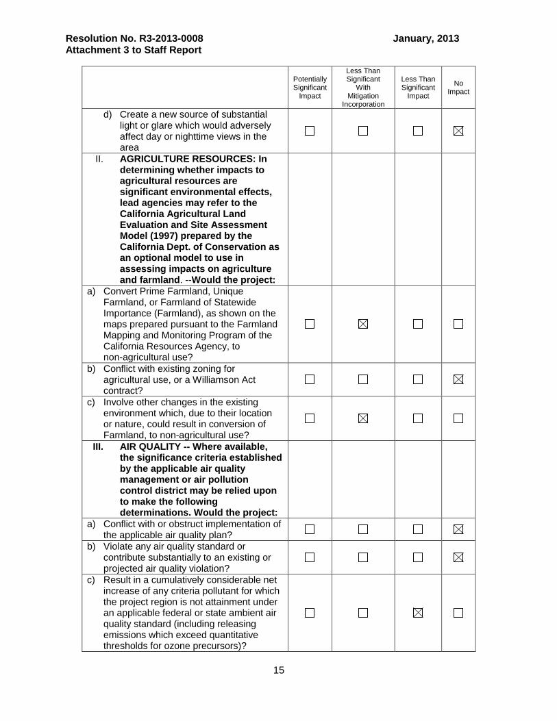
II. AGRICULTURE RESOURCES: In determining whether impacts to agricultural resources are significant environmental effects, lead agencies may refer to the California Agricultural Land Evaluation and Site Assessment Model (1997) prepared by the California Dept. of Conservation as an optional model to use in assessing impacts on agriculture and farmland. --Would the project:
a) Convert Prime Farmland, Unique Farmland, or Farmland of Statewide Importance (Farmland), as shown on the maps prepared pursuant to the Farmland Mapping and Monitoring Program of the California Resources Agency, to non-agricultural use?
b) Conflict with existing zoning for agricultural use, or a Williamson Act contract?
c) Involve other changes in the existing environment which, due to their location or nature, could result in conversion of Farmland, to non-agricultural use?
III. AIR QUALITY -- Where available, the significance criteria established by the applicable air quality management or air pollution control district may be relied upon to make the following determinations. Would the project:
a) Conflict with or obstruct implementation of the applicable air quality plan?
b) Violate any air quality standard or contribute substantially to an existing or projected air quality violation?
c) Result in a cumulatively considerable net increase of any criteria pollutant for which the project region is not attainment under an applicable federal or state ambient air quality standard (including releasing emissions which exceed quantitative thresholds for ozone precursors)?
Resolution No. R3-2013-0008 January, 2013 Attachment 3 to Staff Report
16
Potentially Significant
Impact
Less Than Significant
With Mitigation
Incorporation
Less Than Significant
Impact
No Impact
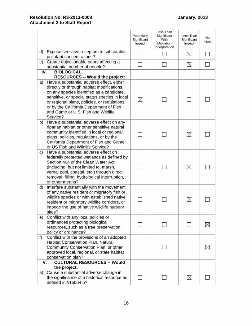
d) Expose sensitive receptors to substantial pollutant concentrations?
e) Create objectionable odors affecting a substantial number of people?
IV. BIOLOGICAL RESOURCES -- Would the project:
a) Have a substantial adverse effect, either directly or through habitat modifications, on any species identified as a candidate, sensitive, or special status species in local or regional plans, policies, or regulations, or by the California Department of Fish and Game or U.S. Fish and Wildlife Service?
b) Have a substantial adverse effect on any riparian habitat or other sensitive natural community identified in local or regional plans, policies, regulations, or by the California Department of Fish and Game or US Fish and Wildlife Service?
c) Have a substantial adverse effect on federally protected wetlands as defined by Section 404 of the Clean Water Act (including, but not limited to, marsh, vernal pool, coastal, etc.) through direct removal, filling, hydrological interruption, or other means?
d) Interfere substantially with the movement of any native resident or migratory fish or wildlife species or with established native resident or migratory wildlife corridors, or impede the use of native wildlife nursery sites?
e) Conflict with any local policies or ordinances protecting biological resources, such as a tree preservation policy or ordinance?
f) Conflict with the provisions of an adopted Habitat Conservation Plan, Natural Community Conservation Plan, or other approved local, regional, or state habitat conservation plan?
V. CULTURAL RESOURCES -- Would the project:
a) Cause a substantial adverse change in the significance of a historical resource as defined in §15064.5?

Resolution No. R3-2013-0008 January, 2013 Attachment 3 to Staff Report
17
Potentially Significant
Impact
Less Than Significant
With Mitigation
Incorporation
Less Than Significant
Impact
No Impact
b) Cause a substantial adverse change in the significance of an archaeological resource pursuant to §15064.5?
c) Directly or indirectly destroy a unique paleontological resource or site or unique geologic feature?
d) Disturb any human remains, including those interred outside of formal cemeteries?
VI. GEOLOGY AND SOILS -- Would the project:
a) Expose people or structures to potential substantial adverse effects, including the risk of loss, injury, or death involving:
i) Rupture of a known earthquake fault, as delineated on the most recent Alquist-Priolo Earthquake Fault Zoning Map issued by the State Geologist for the area or based on other substantial evidence of a known fault? Refer to Division of Mines and Geology Special Publication 42.
ii) Strong seismic ground shaking iii) Seismic-related ground failure,
including liquefaction?
iv) Landslides? b) Result in substantial soil erosion or the
loss of topsoil?
c) Be located on a geologic unit or soil that is unstable, or that would become unstable as a result of the project, and potentially result in on- or off-site landslide, lateral spreading, subsidence, liquefaction or collapse?
d) Be located on expansive soil, as defined in Table 18-1-B of the Uniform Building Code (1994), creating substantial risks to life or property
e) Have soils incapable of adequately supporting the use of septic tanks or alternative waste-water disposal systems where sewers are not available for the disposal of waste water?
VII. GREENHOUSE GAS EMISSIONS Would the project:
a) Create a significant hazard to the public or the environment through the routine transport, use, or disposal of hazardous

Resolution No. R3-2013-0008 January, 2013 Attachment 3 to Staff Report
18
Potentially Significant
Impact
Less Than Significant
With Mitigation
Incorporation
Less Than Significant
Impact
No Impact
b) Conflict with an applicable plan, policy or regulation adopted for the purpose of reducing the emissions of greenhouse gases?
VIII. HAZARDS AND HAZARDOUS MATERIALS
Would the project:
a) Create a significant hazard to the public or the environment through the routine transport, use, or disposal of hazardous materials?
b) Create a significant hazard to the public or the environment through reasonably foreseeable upset and accident conditions involving the release of hazardous materials into the environment?
c) Emit hazardous emissions or handle hazardous or acutely hazardous materials, substances, or waste within one-quarter mile of an existing or proposed school?
d) Be located on a site which is included on a list of hazardous materials sites compiled pursuant to Government Code Section 65962.5 and, as a result, would it create a significant hazard to the public or the environment?
e) For a project located within an airport land use plan or, where such a plan has not been adopted, within two miles of a public airport or public use airport, would the project result in a safety hazard for people residing or working in the project area?
f) For a project within the vicinity of a private airstrip, would the project result in a safety hazard for people residing or working in the project area?
g) Impair implementation of or physically interfere with an adopted emergency response plan or emergency evacuation plan?
h) Expose people or structures to a significant risk of loss injury or death involving wildland fires, including where wildlands are adjacent to urbanized areas or where residences are intermixed with wildlands?
IX. HYDROLOGY AND WATER QUALITY -Would the project:

Resolution No. R3-2013-0008 January, 2013 Attachment 3 to Staff Report
19
Potentially Significant
Impact
Less Than Significant
With Mitigation
Incorporation
Less Than Significant
Impact
No Impact
a) Violate any water quality standards or waste discharge requirements?
b) Substantially deplete ground water supplies or interfere substantially with ground water recharge such that there would be a net deficit in aquifer volume or a lowering of the local ground water table level (e.g., the production rate of pre-existing nearby wells would drop to a level which would not support existing land uses or planned uses for which permits have been granted)?
c) Substantially alter the existing drainage pattern of the site or area, including through the alteration of the course of a stream or river, in a manner which would result in substantial erosion or siltation on- or off-site?
d) Substantially alter the existing drainage pattern of the site or area, including through the alteration of the course of a stream or river, or substantially increase the rate or amount of surface runoff in a manner which would result in flooding on- or off-site?
e) Create or contribute runoff water which would exceed the capacity of existing or planned stormwater drainage systems or provide substantial additional sources of polluted runoff?
f) Otherwise substantially degrade water quality?
g) Place housing within a 100-year flood hazard area as mapped on a federal Flood Hazard Boundary or Flood Insurance Rate Map or other flood hazard delineation map?
h) Place within a 100-year flood hazard area structures which would impede or redirect flood flows?
i) Expose people or structures to a significant risk of loss, injury or death involving flooding, including flooding as a result of the failure of a levee or dam?
j) Inundation by seiche, tsunami, or mudflow?
X. LAND USE AND PLANNING Would the project:

Resolution No. R3-2013-0008 January, 2013 Attachment 3 to Staff Report
20
Potentially Significant
Impact
Less Than Significant
With Mitigation
Incorporation
Less Than Significant
Impact
No Impact
a) Physically divide an established community?
b) Conflict with any applicable land use plan, policy, or regulation of an agency with jurisdiction over the project (including, but not limited to the general plan, specific plan, local coastal program, or zoning ordinance) adopted for the purpose of avoiding or mitigating an environmental effect?
c) Conflict with any applicable habitat conservation plan or natural community conservation plan?
XI. MINERAL RESOURCES -- Would the project:
a) Result in the loss of availability of a known mineral resource that would be of value to the region and the residents of the state?
b) Result in the loss of availability of a locally –important mineral resource recovery site delineated on a local general plan, specific plan or other land use plan?
XII. NOISE Would the project result in:
a) Exposure of persons to or generation of noise levels in excess of standards established in the local general plan or noise ordinance, or applicable standards of other agencies?
b) Exposure of persons to or generation of excessive groundborne vibration or groundborne noise levels?
c) A substantial permanent increase in ambient noise levels in the project vicinity above levels existing without the project?
d) A substantial temporary or periodic increase in ambient noise levels in the project vicinity above levels existing without the project?
e) For a project located within an airport land use plan or, where such a plan has not been adopted, within two miles of a public airport or public use airport, would the project expose people residing or working in the project area to excessive noise levels?
Resolution No. R3-2013-0008 January, 2013 Attachment 3 to Staff Report
21
Potentially Significant
Impact
Less Than Significant
With Mitigation
Incorporation
Less Than Significant
Impact
No Impact
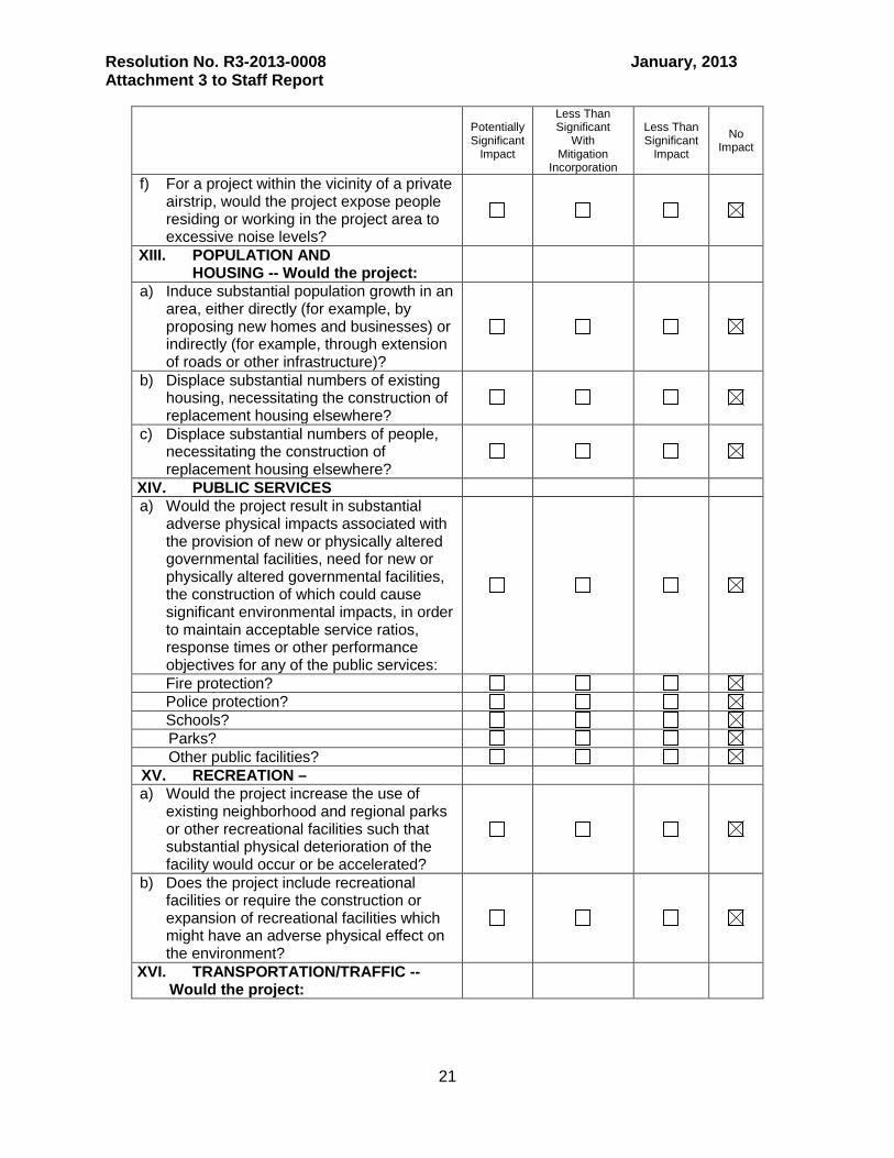
f) For a project within the vicinity of a private airstrip, would the project expose people residing or working in the project area to excessive noise levels?
XIII. POPULATION AND HOUSING -- Would the project:
a) Induce substantial population growth in an area, either directly (for example, by proposing new homes and businesses) or indirectly (for example, through extension of roads or other infrastructure)?
b) Displace substantial numbers of existing housing, necessitating the construction of replacement housing elsewhere?
c) Displace substantial numbers of people, necessitating the construction of replacement housing elsewhere?
XIV. PUBLIC SERVICES a) Would the project result in substantial
adverse physical impacts associated with the provision of new or physically altered governmental facilities, need for new or physically altered governmental facilities, the construction of which could cause significant environmental impacts, in order to maintain acceptable service ratios, response times or other performance objectives for any of the public services:
Fire protection? Police protection? Schools? Parks? Other public facilities? XV. RECREATION – a) Would the project increase the use of
existing neighborhood and regional parks or other recreational facilities such that substantial physical deterioration of the facility would occur or be accelerated?
b) Does the project include recreational facilities or require the construction or expansion of recreational facilities which might have an adverse physical effect on the environment?
XVI. TRANSPORTATION/TRAFFIC -- Would the project:

Resolution No. R3-2013-0008 January, 2013 Attachment 3 to Staff Report
22
Potentially Significant
Impact
Less Than Significant
With Mitigation
Incorporation
Less Than Significant
Impact
No Impact
a) Cause an increase in traffic which is substantial in relation to the existing traffic load and capacity of the street system (i.e., result in a substantial increase in either the number of vehicle trips, the volume to capacity ratio on roads, or congestion at intersections)?
b) Exceed, either individually or cumulatively, a level of service standard established by the county congestion management agency for designated roads or highways?
c) Result in a change in air traffic patterns, including either an increase in traffic levels or a change in location that results in substantial safety risks?
d) Substantially increase hazards due to a design feature (e.g., sharp curves or dangerous intersections) or incompatible uses (e.g., farm equipment)?
e) Result in inadequate emergency access?
f) Result in inadequate parking capacity?
g) Conflict with adopted policies, plans, or programs supporting alternative transportation (e.g., bus turnouts, bicycle racks)?
XVII. UTILITIES AND SERVICE SYSTEMS -Would the project:
a) Exceed wastewater treatment requirements of the applicable Regional Water Quality Control Board?
b) Require or result in the construction of new water or wastewater treatment facilities or expansion of existing facilities, the construction of which could cause significant environmental effects?
c) Require or result in the construction of new storm water drainage facilities or expansion of existing facilities, the construction of which could cause significant environmental effects?
d) Have sufficient water supplies available to serve the project from existing entitlements and resources, or are new or expanded entitlements needed?

Resolution No. R3-2013-0008 January, 2013 Attachment 3 to Staff Report
23
Potentially Significant
Impact
Less Than Significant
With Mitigation
Incorporation
Less Than Significant
Impact
No Impact
e) Result in a determination by the wastewater treatment provider which serves or may serve the project that it has adequate capacity to serve the project's projected demand in addition to the provider's existing commitments?
f) Be served by a landfill with sufficient permitted capacity to accommodate the project's solid waste disposal needs?
g) Comply with federal, state, and local statutes and regulations related to solid waste?
XVIII. MANDATORY FINDINGS OF SIGNIFICANCE
a) Does the project have the potential to degrade the quality of the environment, substantially reduce the habitat of a fish or wildlife species, cause a fish or wildlife population to drop below self-sustaining levels, threaten to eliminate a plant or animal community, reduce the number or restrict the range of a rare or endangered plant or animal or eliminate important examples of the major periods of California history or prehistory?
b) Does the project have impacts that are individually limited, but cumulatively considerable? (“Cumulatively considerable" means that the incremental effects of a project are considerable when viewed in connection with the effects of past projects, the effects of other current projects, and the effects of probable future projects)?
c) Does the project have environmental effects which will cause substantial adverse effects on human beings, either directly or indirectly?
4. ENVIRONMENTAL EVALUATION DISCUSSION The Environmental Substitute Document must include an analysis of the reasonably foreseeable environmental impacts of the methods of compliance, and the reasonably foreseeable mitigation measures relating to those impacts. A significant effect on the environment is defined in regulation as:

Resolution No. R3-2013-0008 January, 2013 Attachment 3 to Staff Report
24
“a substantial, or potentially substantial, adverse change in any of the physical conditions within the area affected by the project, including land, air, water, minerals, flora, fauna, ambient noise, and objects of historic or aesthetic significance. A social or economic change by itself shall not be considered a significant effect on the environment. A social or economic change related to a physical change may be considered in determining whether the physical change is significant (14 CCR section 15382).” I. AESTHETICS -- Would the project: (a) – Have a substantial adverse effect on a scenic vista?
Answer: No impact. Discussion: None of the reasonably foreseeable non-structural (e.g., nutrient management, and other source controls) or structural methods (e.g., vegetated treatment systems) of compliance methods identified in Section 2. are expected to have an adverse impact on a scenic vista. Structural methods of compliance do not require the permanent construction of a sizable structure that would either block a scenic vista or substantially degrade the scenic vista. Further, the TMDL project area does not have designated vista sites located on the California State Highway System, according to GIS data available from the Calf. Dept. of Transportation (see Figure 1). (b) – Substantially damage scenic resources, including, but not limited to, trees, rock outcroppings, and historic buildings within a state scenic highway?
Answer: No impact. Discussion: There are two sections of designated state scenic highways in the TMDL project area according to GIS data from the Calif. Dept. of Transportation: 1) Highway 156 from 1 mile east of Castroville to State Route 101 near Prunedale (4.3 total miles); and 2) Highway 68 from the Salinas River and paralleling El Toro Creek to the western drainage divide of the El Toro Creek subwatershed (6.1 total miles) – see Figure 1. Most of the collective total reach of state scenic highway in the TMDL project area (10.4 miles) are not associated with areas that are expected to require implementation of compliance methods (i.e., irrigated cropland, or MS4 drainage systems). Reasonably foreseeable methods of compliance identified in Section 2. do not require the building of structures that would damage natural or human made resources to the extent that it would impede the scenic quality of the area or scenic resources associated with state scenic highways. Indeed, some of the methods of compliance, for example increases in riparian vegetation, and some types of vegetative treatment systems, would be aesthetic improvements to the TMDL project area. For example, efforts by the City of Salinas and local citizens to improve urban watersheds and increase riparian habitat have reportedly substantially increased the aesthetic value of the lower reaches of Natividad Creek.

Resolution No. R3-2013-0008 January, 2013 Attachment 3 to Staff Report
25
Figure 1. State scenic highways & CalTrans-designated scenic vistas.
(c) – Substantially degrade the existing visual character or quality of the site and its surroundings?
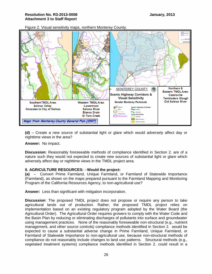
Answer: No impact. Discussion: Reasonably foreseeable methods of compliance identified in Section 2. are of such a nature such that they are not expected to degrade the visual character or quality within the TMDL project area. Indeed, some of the methods of compliance, for example increases in riparian vegetation, and some types of vegetative treatment systems, would be aesthetic improvements to the TMDL project area. Also noteworthy is that there are virtually no areas designated as sensitive and highly sensitive visual resources in the valley floor areas of the TMDL project area, as identified in the Monterey County General Plan (2007) – see Figure 2. This information provides supplementary evidence that structural compliance methods - which are expected to largely occur in valley floor agricultural and urban areas - would not degrade the visual character of the TMDL project area.
Resolution No. R3-2013-0008 January, 2013 Attachment 3 to Staff Report
26
Figure 2. Visual sensitivity maps, northern Monterey County.
(d) – Create a new source of substantial light or glare which would adversely affect day or nighttime views in the area?
Answer: No impact. Discussion: Reasonably foreseeable methods of compliance identified in Section 2. are of a nature such they would not expected to create new sources of substantial light or glare which adversely affect day or nighttime views in the TMDL project area. II. AGRICULTURE RESOURCES: --Would the project: (a) – Convert Prime Farmland, Unique Farmland, or Farmland of Statewide Importance (Farmland), as shown on the maps prepared pursuant to the Farmland Mapping and Monitoring Program of the California Resources Agency, to non-agricultural use? Answer: Less than significant with mitigation incorporation. Discussion: The proposed TMDL project does not propose or require any person to take agricultural lands out of production. Rather, the proposed TMDL project relies on implementation based on an existing regulatory program adopted by the Water Board (the Agricultural Order). The Agricultural Order requires growers to comply with the Water Code and the Basin Plan by reducing or eliminating discharges of pollutants into surface and groundwater using management practices. None of the reasonably foreseeable non-structural (e.g., nutrient management, and other source controls) compliance methods identified in Section 2. would be expected to cause a substantial adverse change in Prime Farmland, Unique Farmland, or Farmland of Statewide Importance to non-agricultural use, because non-structural methods of compliance do not reasonably include changes to land use patterns. Structural methods (e.g., vegetated treatment systems) compliance methods identified in Section 2. could result in a

Resolution No. R3-2013-0008 January, 2013 Attachment 3 to Staff Report
27
substantial adverse change pertaining to conversion to non-agricultural use of Prime Farmland, Unique Farmland, or Farmland of Statewide Importance because some incidental amounts of these lands could be converted to non-agricultural uses (e.g., constructed wetlands) as described below. These actions can be expected to be less than significant with mitigation incorporation as described below. Nutrient control strategies and measures in agricultural watersheds have been underway for many years in various agricultural watersheds in the State and throughout the nation. Based on the literature, research, and information staff has surveyed for this project, we are unaware of any cases where nutrient control strategies have directly been responsible for substantial or widespread adverse impacts resulting in the conversion of farmland to non-agricultural uses. Dischargers may choose to install riparian habitat buffer strips or vegetated treatment systems as identified in Section 2. to implement the proposed TMDL and comply with the Agricultural Order. These actions could result in taking incidental amounts of land out of crop production. Where dischargers choose to install riparian habitat buffers to control discharges of waste, some farm land could be taken out of production Some structural treatment practices identified in Section 2. such as riparian buffers and vegetated treatment systems (e.g., wetlands) could result in conversion of farmland to non-agricultural uses. As discussed in the Final Subsequent Environmental Impact Report (March 17, 2011) Agricultural Order, if all growers in Tier 3 chose to install buffer strips to comply with the Agricultural Order, approximately 82 to 233 acres or 0.002 to 0.004% of the 540,000 acres of agricultural lands within the Region, would be taken out of production. This is because riparian buffers only affect a very narrow band of land on either side of a waterbody. Given the total number of acres farmed in the Central Coast Region, the impact on acres farmed does not constitute a substantial adverse conversion of farmland to non-agricultural uses even if all 233 acres in the Central Coast Region were converted to some other use. This estimate represents the acreage of land that would be taken out of production if all growers chose to install riparian habitat buffers and all of those buffers did not yield any agricultural products. The estimate may be less than this because of alternative means of compliance and/or mitigation. The TMDL project and the Agricultural Order which is proposed to implement the TMDL do not require the use of buffers; other methods may be used or the discharges may not be significant due to existing practices. Constructed wetlands or other types of vegetated treatment systems could potentially result in a substantial adverse conversion of farmland because these types of systems are anticipated to require more acreage than buffer strips. Mitigation strategies to reduce the adverse impacts of these systems to less than significant have been provided to Water Board staff by reputable local resource professionals7; these include appropriate design and location strategies as outlined below:
1) building vegetated treatments systems on small parcels that are already out of production and with minimal intrinsic habitat (e.g., woodchip reactors on the small vacant area that is often adjacent to existing tile-drain pumps); 2) Use larger-area cooperative systems – larger systems have a low circumference: area ratios, and thus less agricultural/habitat contact per unit of water quality improvement;
7 Dr. Fred Watson, Assistant Professor, California State University Monterey Bay and Mr. Ross Clark, Director of Central Coast Wetlands Group at Moss Landing Marine Laboratories.

Resolution No. R3-2013-0008 January, 2013 Attachment 3 to Staff Report
28
3) Utilize other location strategies to mitigate impacts; e.g., using the lowest lying areas whose inundation is already increasingly problematic (for example, due to sea level rise, urban expansion, and higher impervious area), or identifying areas of currently non-productive agricultural land adjacent to waterbodies that could be used for treatment wetlands. Indeed, a prominent local resource professional has indicated to Water Board staff that they have already identified hundreds of acres of non-productive agricultural land (left fallow because it is too wet to be used for viable crops) adjacent to channels and waterbodies that might be used for vegetated treatment systems (personal communication, Mr. Ross Clark, Director of Central Coast Wetlands Group at Moss Landing Marine Laboratories, May 2, 2012). (b) – Conflict with existing zoning for agricultural use, or a Williamson Act contract? Answer: No Impact. None of the reasonably foreseeable non-structural or structural compliance methods identified in Section 2. would be expected to conflict with existing zoning for agricultural uses, or a Williamson Act contract. Also noteworthy is that the overwhelming majority of Williamson Act Lands in the TMDL project area are located in upland, rangeland, and headwater reaches (Figure 3) which are not anticipated to require widespread implementation of compliance methods.
Figure 3. Williamson Act Lands.
(c) – Involve other changes in the existing environment which, due to their location or nature, could result in conversion of Farmland, to non-agricultural use? Answer: Less than significant with mitigation incorporation.

Resolution No. R3-2013-0008 January, 2013 Attachment 3 to Staff Report
29
Discussion: Refer back to previous responses under Heading II.(a). Further, an additional potentially substantial adverse conversion of farmland to non-agricultural land could possibly indirectly result from food safety issues. Concerns have been raised about vegetated treatment systems attracting wildlife which might impact leafy green production and risk food safety, thereby indirectly taking viable farmland out of viable production due to issues arising from food safety risks. Possible mitigation strategies to reduce these adverse impacts to less than significant have been provided to Water Board staff by a prominent local resource professional (Mr. Ross Clark, Director Central Coast Wetlands Group at Moss Landing Marine Laboratories, via personal communication May 2, 2012). There are several food safety task forces working to develop better guidelines describing what wetland, creek and treatment wetland related sources and vectors can potentially impact leafy green production and risk food safety. Resource professionals at the Central Coast Wetlands Group at Moss Landing Marine Laboratories could be working with these experts to design treatment wetlands that do not attract wildlife. It should be noted that many animals (birds, rodents, dear etc.) in fact presently use degraded drainages. Food safety risk can be mitigated through rodent fencing, raptor poles to reduce rodent populations, proper selection of plant species that deter pest species, and proper wetland feature design and planting to minimize open water habitat that attract geese and other waterfowl. Also, because these are isolated systems within the landscape they cannot be used as migration corridors by animals. III. AIR QUALITY -- Where available, the significance criteria established by the applicable air quality management or air pollution control district may be relied upon to make the following determinations. Would the project:
(a) – Conflict with or obstruct implementation of the applicable air quality plan?
Answer: No Impact Discussion: None of the reasonably foreseeable methods of compliance methods identified in Section 2. would be expected to result in any conflicts with or obstruction to the implementation of the applicable air quality plan. (b) – Violate any air quality standard or contribute substantially to an existing or projected air quality violation? Answer: No Impact Discussion: None of the reasonably foreseeable methods of compliance methods identified in Section 2. would be expected to result in any violation of air quality standards or contribute substantially to an existing or projected air quality violation (c) – Result in a cumulatively considerable net increase of any criteria pollutant for which the project region is not attainment under an applicable federal or state ambient air quality standard (including releasing emissions which exceed quantitative thresholds for ozone precursors)?
Answer: Less than significant. Discussion: Neither the structural nor the non-structural reasonably foreseeable compliance methods identified in Section 2. will result in a cumulatively considerable net increase of any criteria pollutant for which the region is non-attainment under an applicable federal or state ambient air quality standard.

Resolution No. R3-2013-0008 January, 2013 Attachment 3 to Staff Report
30
The implementation of structural BMPs that could result in fine particulate matter and vehicle emissions, such as the BMPs land disturbance and excavation could contribute to the problems with these pollutants. However, any contribution would be very small, and nominal given both the temporary nature of any such impacts and the fairly small nature of any such construction activity given the size of the basin. Therefore, these impacts do not constitute substantial, or potentially substantial, adverse changes to air quality and criteria pollutants. (d) – Expose sensitive receptors to substantial pollutant concentrations?
Answer: Less than significant Discussion: Neither the structural nor the non-structural reasonably foreseeable compliance methods identified in Section 2. will result in a cumulatively considerable net increase of any criteria pollutant for which the region is non-attainment under an applicable federal or state ambient air quality standard. The implementation of structural BMPs that could result in fine particulate matter and vehicle emissions, such as the BMPs land disturbance and excavation could contribute to the problems with these pollutants. However, any contribution would be very small, and nominal given both the temporary nature of any such impacts and the fairly small nature of any such construction activity given the size of the basin. Therefore, these impacts do not constitute substantial, or potentially substantial, adverse exposure to sensitive receptors to substantial pollutant concentrations. (e) – Create objectionable odors affecting a substantial number of people?
Answer: Less than significant Discussion: Neither the structural nor the non-structural reasonably foreseeable compliance methods identified in Section 2. will result in a cumulatively considerable net increase of any criteria pollutant for which the region is non-attainment under an applicable federal or state ambient air quality standard. The implementation of structural BMPs that could result in fine particulate matter and vehicle emissions, such as the BMPs land disturbance and excavation could contribute to the problems with these pollutants. However, any contribution would be very small, and nominal given both the temporary nature of any such impacts and the fairly small nature of any such construction activity given the size of the basin. Therefore, these impacts do not constitute substantial, or potentially substantial, adverse change pertaining to creation of objectionable odors affecting a substantial number of people. IV. BIOLOGICAL RESOURCES -- Would the project: (a) – Have a substantial adverse effect, either directly or through habitat modifications, on any species identified as a candidate, sensitive, or special status species in local or regional plans, policies, or regulations, or by the California Department of Fish and Game or U.S. Fish and Wildlife Service?
Answer: Potentially significant impact. Discussion: The Central Coast Water Board requires implementation by responsible parties who own property that may potentially contain special-status species. There are 55 rare, sensitive, threatened or endangered species in the TMDL project area according to digital shape files

Resolution No. R3-2013-0008 January, 2013 Attachment 3 to Staff Report
31
available from the California Natural Diversity Database (CNDDB, data from June, 2008) – see Table 1. The CNDDB is a program that inventories the status and location of rare plants, animals and insects in California. Of the 55 species in the project area, 43 occur in project area lands classified as farmland or urban where most TMDL implementation will take place8. Some of these species may live in habitats similar to those in areas where compliance methods will be needed. Reasonably foreseeable compliance measures identified in Section 2. may have a potentially adverse impact upon rare, sensitive, threatened or endangered species if they occur in an area where such species are located. When installing structural compliance methods that involve significant earth-moving or land disturbance in areas where sensitive species are located shall consult with California Department of Fish and Game and the U.S. Fish and Wildlife Service prior to implementing compliance measures and implement mitigation identified by the agencies to avoid impacts to rare, threatened or endangered species. If no such mitigation is available, the activity would not be permitted without additional review and findings. It is anticipated that in most cases installation of structural compliance measures would be of relatively small scale and any impacts could be avoided by adjusting the timing and/or location of the compliance measures to take into account rare, sensitive, threatened or endangered species or their habitats. In addition, alternatives to activities that involve land disturbance may be employed, such as use bioreactors (wood chips), irrigation and nutrient non-structural control measures, or moving crops rows in in a direction parallel to riparian zones to reduce runoff. Structural or non-structural compliance methods identified in Section 2. that may potentially result in reduced flows in waterbodies (e.g., reductions in tailwater discharge) may have the potential to have a substantial adverse impact on rare, sensitive, threatened or endangered species or their habitats. However, at this time, specific data and evidence to support this position were not found. Both U.S. Fish and Wildlife and the California Department of Parks have previously opined that there may be potentially significant adverse impacts related to reduction in flows9, however U.S. Fish and Wildlife Service indicated that there are a range of possibilities. Reduced flow may benefit native species in the long run, making it harder for invasive species to survive. Reduced flows would likely allow the hydrology to go back to a more natural state; however, it could have negative effects by potentially reducing stream flows and associated freshwater aquatic habitat in areas inhabited by sensitive, rare, threatened or endangered species The potential negative effects noted above are dependent on many variables including where the flow is reduced, by how much and at what times of the year. State Parks’ position was similar. State Parks discussed that there would likely be an adjustment period. They suggested further hydrological analysis in these areas where there are special status species with certain water requirements. Additionally, State Parks suggested mitigation measures such as phasing in implementation of requirements in some areas and adjusting them on a watershed basis. In addition, note that reductions in surface runoff (tailwater discharge) may in fact result in increased percolation to groundwater resulting in an increased potential for shallow groundwater baseflow which could continue to support viable stream flows. As shown in the TMDL Project Report, available U.S. Geological Survey Stream gage flow data in the project area generally indicates that baseflow is an important hydrologic process in the project area.
8 Based on the spatial intersection of Calif. Dept. of Conservation Farmland Mapping and Monitoring program digital land use shape files classified as farmland or urban, and CNDDB shape files within the TMDL project area 9 See Final Subsequent Environmental Impact Report, Staff Recommendations for Agricultural Order, March 2011, Central Coast Regional Water Quality Control Board.

Resolution No. R3-2013-0008 January, 2013 Attachment 3 to Staff Report
32
Further, while rare, sensitive, threatened or endangered species are found on or adjacent to irrigated agricultural lands or census-designated urbanized areas in the project area, there are likely negative effects on these species because of current water quality degradation and excess nutrients associated with agricultural discharges. In other words, while rare, sensitive, threatened or endangered species may be present in areas with substantial amounts of regulated flows and agricultural return flows, excessive levels of nutrients, low dissolved oxygen, toxicity due to unionized ammonia and water quality degradation are not considered to be a desirable condition for the health and long term sustainability of these species. It is widely acknowledged by many resource professionals and in the scientific literature (refer to TMDL Project Report) that water quality degradation, stream alteration, and human activities have, on balance, have constituted an adverse impact to the natural biodiversity of the lower Salinas Valley. Consequently, while sensitive species may be present in some areas because of the discharged water, continuing to discharge water of low quality is not an environmentally desirable or sustainable practice with respect to the viability of sensitive species. Potential mitigation measures to prevent reduced flows or to reduce the impact of reduced flows include phasing in management practices that could result in reduced flows; and use of riparian buffers and other vegetated treatment systems that will effectively treat the water to remove pollutants, but not necessarily reduce flows. Because of the mitigation strategies shown above, and because of the net corollary benefits to wildlife resulting from foreseeable compliance measures, potential substantial adverse effects are possible to a candidate, sensitive, or special status species in local or regional plans, policies, or regulations, or by the California Department of Fish and Game or U.S. Fish and Wildlife Service, but are not anticipated to occur. Table 1. Rare, sensitive, threatened or endangered species in TMDL project area.
SCIENTIFIC NAME COMMON NAME FEDERAL
LEGAL STATUS
CALIF. LEGAL
STATUS
STATE RANKING THREAT
DESIGNATION Malacothamnus palmeri var. involucratus Carmel Valley bush-mallow None None S2.2 Ambystoma californiense California tiger salamander Threatened None S2S3 Centromadia parryi ssp. congdonii Congdon's tarplant None None S3.2 Charadrius alexandrinus nivosus western snowy plover Threatened None S2 Horkelia cuneata ssp. sericea Kellogg's horkelia None None S1.1 Phrynosoma coronatum (frontale population) coast (California) horned lizard None None S3S4 Anniella pulchra nigra black legless lizard None None S2 Reithrodontomys megalotis distichlis Salinas harvest mouse None None S1 Gilia tenuiflora ssp. arenaria sand gilia Endangered Threatened S2.2 Chorizanthe pungens var. pungens Monterey spineflower Threatened None S2.2 Tryonia imitator mimic tryonia (=California brackishwater snail) None None S2S3 Agelaius tricolor tricolored blackbird None None S2 Trifolium buckwestiorum Santa Cruz clover None None S1.1 Linderiella occidentalis California linderiella None None S2S3 Rana draytonii California red-legged frog Threatened None S2S3 Ericameria fasciculata Eastwood's goldenbush None None S2.1 Rosa pinetorum pine rose None None S2.2 Arctostaphylos pajaroensis Pajaro manzanita None None S2.1 Arctostaphylos montereyensis Toro manzanita None None S2.1 Actinemys marmorata pallida southwestern pond turtle None None S2 Eriogonum nortonii Pinnacles buckwheat None None S2.3 Lasthenia conjugens Contra Costa goldfields Endangered None S1.1 Euphilotes enoptes smithi Smith's blue butterfly Endangered None S1S2

Resolution No. R3-2013-0008 January, 2013 Attachment 3 to Staff Report
33
SCIENTIFIC NAME COMMON NAME FEDERAL
LEGAL STATUS
CALIF. LEGAL
STATUS
STATE RANKING THREAT
DESIGNATION Athene cunicularia burrowing owl None None S2 Cordylanthus rigidus ssp. littoralis seaside bird's-beak None Endangered S1.1 Taxidea taxus American badger None None S4 Central Dune Scrub Central Dune Scrub None None S2.2 Erysimum ammophilum sand-loving wallflower None None S2.2 Coelus globosus globose dune beetle None None S1 Trifolium depauperatum var. hydrophilum saline clover None None S2.2? Coastal Brackish Marsh Coastal Brackish Marsh None None S2.1 Falco mexicanus prairie falcon None None S3 Allium hickmanii Hickman's onion None None S2.2 Ambystoma macrodactylum croceum Santa Cruz long-toed salamander Endangered Endangered S1 Piperia yadonii Yadon's rein orchid Endangered None S2.1 Stebbinsoseris decipiens Santa Cruz microseris None None S2.2 Valley Needlegrass Grassland Valley Needlegrass Grassland None None S3.1 Riparia riparia bank swallow None Threatened S2S3 Arctostaphylos hookeri ssp. hookeri Hooker's manzanita None None S2? Eucyclogobius newberryi tidewater goby Endangered None S2S3 Asio flammeus short-eared owl None None S3 Delphinium hutchinsoniae Hutchinson's larkspur None None S2.1 Thamnophis hammondii two-striped garter snake None None S2 Accipiter cooperii Cooper's hawk None None S3 Central Maritime Chaparral Central Maritime Chaparral None None S2.2 Eremophila alpestris actia California horned lark None None S3 Erysimum menziesii ssp. yadonii Yadon's wallflower Endangered Endangered S1.1 Chorizanthe robusta var. robusta robust spineflower Endangered None S1.1 Northern Coastal Salt Marsh Northern Coastal Salt Marsh None None S3.2 Helminthoglypta sequoicola consors redwood shoulderband None None S1 Arctostaphylos gabilanensis Gabilan Mountains manzanita None None S1.2 Arctostaphylos pumila sandmat manzanita None None S2.2 Danaus plexippus monarch butterfly None None S3 Astragalus tener var. tener alkali milk-vetch None None S1.1 Fritillaria liliacea fragrant fritillary None None S2.2 The State Rank (S-rank) is a ranking methodology which is intended to reflect of the overall conditions and conservation status of an element over its state distribution to inform biodiversity conservation. State Ranking Threat Designations S1 = Less than 6 EOs OR less than 1,000 individuals OR less than 2,000 acres S1.1 = very threatened S1.2 = threatened S1.3 = no current threats known S2 = 6-20 EOs OR 1,000-3,000 individuals OR 2,000-10,000 acres S2.1 = very threatened S2.2 = threatened S2.3 = no current threats known S3 = 21-100 EOs or 3,000-10,000 individuals OR 10,000-50,000 acres S3.1 = very threatened S3.2 = threatened S3.3 = no current threats known S4 - Apparently secure within California; this rank is clearly lower than S3 but factors exist to cause some concern; i.e. there is some threat, or somewhat narrow habitat. NO THREAT RANK. S5 - Demonstrably secure to ineradicable in California. NO THREAT RANK.
(b) – Have a substantial adverse effect on any riparian habitat or other sensitive natural community identified in local or regional plans, policies, regulations, or by the California Department of Fish and Game or US Fish and Wildlife Service?

Resolution No. R3-2013-0008 January, 2013 Attachment 3 to Staff Report
34
Answer: Less than significant Discussion: Substantial adverse effects on any riparian habitat or other sensitive natural community are not anticipated because the reasonably foreseeable compliance methods identified in Section 2. promote and envision the protection of riparian areas, and increases in the amount of riparian vegetation. To the extent these compliance methods result in increased amounts of riparian vegetation in the project area, these are expected to be a net benefit to sensitive communities. None of the reasonably foreseeable compliance methods would have the potential to adversely affect any riparian habitat or other sensitive natural community of plants identified in local or regional plans, policies, regulations, or by the CDFG or USFWS. (c) – Have a substantial adverse effect on federally protected wetlands as defined by Section 404 of the Clean Water Act (including, but not limited to, marsh, vernal pool, coastal, etc.) through direct removal, filling, hydrological interruption, or other means?
Answer: Less than significant. Discussion: Neither the structural nor the non-structural reasonably foreseeable compliance methods identified in Section 2. are anticipated to have a substantial adverse impact on federally protected wetlands as defined by Section 404 of the Clean Water Act. This is because compliance methods identified would generally promote and envision the protection of wetlands, or the construction of new, engineered wetlands to the extent these compliance methods pertain to wetlands. The application of compliance measures in federally protected wetland areas would not be allowed if doing so would affect the beneficial uses associated with that wetland. All activities in federally protected wetlands, except those statutory exemption like agricultural, require the responsible party to obtain a Clean Water Act 404 permit. The federal permit must include compliance measures that ensure that all water quality objectives for the wetland are protected. Implementation of most BMPs would not be allowed within a wetland because doing so would interfere with the protection of the beneficial uses of that wetland. For example, any BMP that required construction, such as a filtration or siltation basin, would not be allowed in the wetland because it would interfere with the beneficial uses of the wetland. (d) – Interfere substantially with the movement of any native resident or migratory fish or wildlife species or with established native resident or migratory wildlife corridors, or impede the use of native wildlife nursery sites?
Answer: Less than significant Discussion: Reasonably foreseeable compliance methods identified in Section 2. will not substantially interfere with migratory fish or wildlife because structural compliance methods are not required within stream beds or in waters of the steams Also, reasonably foreseeable compliance methods are not anticipated to be spatially large-scale, contiguous, or numerous enough to block migration or use of wildlife nursery sites. Indeed to the extent riparian and wetland protection, restoration and enhancement occurs in the project area consistent with identified compliance methods, the movement of any native resident or migratory fish or wildlife species should be expected to be enhanced. (e) – Conflict with any local policies or ordinances protecting biological resources, such as a tree preservation policy or ordinance?

Resolution No. R3-2013-0008 January, 2013 Attachment 3 to Staff Report
35
Answer: No impact. Discussion: None of the reasonably foreseeable non-structural or structural compliance methods identified in Section 2. would be expected to conflict with ordinances protecting biological resources, such as a tree preservation policy or ordinance (f) – Conflict with the provision of an adopted Habitat Conservation Plan, Natural Community Conservation Plan, or other approved local, regional, or state habitat conservation plan?
Answer: No impact. Based on available data there are no Habitat Conservation Plans (HCPs) or Natural Community Conservation Plans (NCCPs) currently located in the TMDL project area (see Figure 4); therefore there are no impacts to HCPs or NCCPs. Figure 4. Boundaries of Conservations Plans (boundary dataset from Cal. Dept. Fish & Game).
It is unlikely that the reasonably foreseeable compliance methods identified in Section 2. would conflict with the provisions of another approved local, regional, or state habitat conservation plan. Indeed, the TMDL project and foreseeable compliance methods are in fact compatible with existing policies outlined in the Monterey County General Plan (January, 2007), as illustrated below:

Resolution No. R3-2013-0008 January, 2013 Attachment 3 to Staff Report
36
From: Monterey County General Plan Adopted January 3, 2007 Conservation and Open Space Element Policies
OS-4.1 Federal and State designated native marine and fresh water species or subspecies of a bird, mammal, fish, amphibian, reptile, or plant shall be protected. Species designated in Area Plans shall also be protected.
OS-4.2 Direct and indirect discharges of harmful substances into marine waters, rivers or streams shall not exceed state or federal standards.
OS-4.3 Estuaries, salt and fresh water marshes, tide pools, wetlands, sloughs, river and stream mouth areas, plus all waterways that drain and have impact on State designated Areas of Special Biological Significance (ASBS) shall be protected, maintained, and preserved in accordance with state and federal water quality regulations.
OS-5.12 The California Department of Fish and Game shall be consulted and appropriate measures shall be taken to protect Areas of Special Biological Significance (ASBS) for State and federally listed species.
More likely, the compliance methods would be similar to measures already committed to under other habitat and conservation plans. Such similarities would likely ensure that compliance methods are in alignment with any adopted Habitat Conservation Plan, Natural Community Conservation Plan or other approved local, regional, or state habitat conservation plan. V. CULTURAL RESOURCES -- Would the project: (a) –Cause a substantial adverse change in the significance of a historical resource as defined in §15064.5?
Answer: Less than significant. Discussion: Substantial, or potentially substantial, adverse changes to the significance of historical resources as defined in CEQA regulations is not expected to result from the TMDL project. The implementation of non-structural reasonably foreseeable compliance methods identified in Section 2. would not result in a substantial adverse change of a significant historical resource. This is because non-structural compliance methods do not involve land-disturbance or physical effects. Similarly, staff concludes it is unlikely that implementation of any structural compliance method identified in Section 2. would result in a substantial adverse change in the significance of a historical resource. Most of these compliance methods do not involve substantial or large-scale land disturbance to land which has not been disturbed previously (e.g., irrigated cropland or urban stormwater conveyance structures). If installation of structural BMPs which may involve large scale excavation or land-disturbance activities, or if the construction of a large scale infrastructure is to be conducted, a cultural resources investigation should be conducted before any substantial disturbance of land that has not been disturbed previously. The cultural resources investigation will include, at a minimum, a records search for previously identified cultural resources and previously conducted cultural resources investigations of the project parcel and vicinity. Figure 5 depicts the existing known historical resources in the TMDL project area, which number approximately two dozen sites. Notable historic resources in the TMDL project area include the Site of the Battle of Natividad near Salinas and the Jose Eusebio Boronda Adobe Casa in Boronda (source: Monterey County 2007 General Plan).

Resolution No. R3-2013-0008 January, 2013 Attachment 3 to Staff Report
37
Figure 5. Location of historic resources in Monterey County.
(b) –Cause a substantial adverse change in the significance of an archaeological resource pursuant to §15064.5?
Answer: Less than significant. Discussion: Substantial, or potentially substantial, adverse changes to the significance of an archaeological resource as defined in CEQA regulations is not expected to result from the TMDL project. The implementation of non-structural foreseeable compliance methods identified in Section 2. would not result in a substantial adverse change of a significant archaeological resource. This is because non-structural compliance methods do not involve land-disturbance or physical effects. Similarly, staff concludes it is unlikely that implementation of any structural compliance method identified in Section 2. would result in a substantial adverse change in the significance of an archaeological resource. Most of these compliance methods do not involve substantial or large-scale land disturbance to land which has not been disturbed previously (e.g., irrigated cropland or urban stormwater conveyance structures). If installation of structural BMPs which may involve large scale excavation or land-disturbance activities, or if the construction of a large scale infrastructure is to be conducted, a cultural resources investigation

Resolution No. R3-2013-0008 January, 2013 Attachment 3 to Staff Report
38
should be conducted before any substantial disturbance of land that has not been disturbed previously. The cultural resources investigation will include, at a minimum, a records search for previously identified cultural resources and previously conducted cultural resources investigations of the project parcel and vicinity. This record search should also include, at a minimum, contacting the appropriate information center of the California Historical Resources Information System, operated under the auspices of the California Office of Historic Preservation. In coordination with the information center or a qualified archaeologist, a determination regarding whether previously identified cultural resources will be affected by the proposed project must be made and if previously conducted investigations were performed to satisfy the requirements of CEQA. If not, a cultural resources survey would need to be conducted. The purpose of this investigation would be to identify resources before they are affected by a proposed project and avoid the impact. If the impact is unavoidable, mitigation will be determined on a case-by-case basis, as warranted. For informational purposes, Figure 6 depicts zones of estimated archeological sensitivity in Monterey County and the TMDL project (source: Monterey County 2007 General Plan). Sensitivity zones include a number of considerations and assumptions. The considerations include known archeological resources, as well as defining higher sensitivity zones on the well-founded observations of archeologists that stream courses and drainages are common historical locations of human occupation or use. Figure 6. Estimated archeological sensitivity in Monterey County.
(c) –Directly or indirectly destroy a unique paleontological resource or site or unique geologic feature?
Answer: Less than significant.

Resolution No. R3-2013-0008 January, 2013 Attachment 3 to Staff Report
39
Discussion: Direct or indirect destruction of a unique paleontological resource or site or unique geologic feature is not expected to result from the TMDL project. The implementation of non-structural foreseeable compliance methods identified in Section 2. would not result in would not directly or indirectly destroy a unique paleontological resource or site or unique geologic feature because these compliance methods do not involve land-disturbance or physical effects. Similarly, it is unlikely that implementation of any structural BMP would result in the destruction of a unique paleontological resource or site or unique geologic feature. However, in cases where the installation of structural BMPs may involve excavation activities, an investigation of paleontological resources may need to be conducted by a trained professional before any substantial disturbance of land that has not been disturbed previously. With regard to existing and known significant paleontological resources, Figure 7 depicts the approximate locations of paleontological sites considered by paleontologists to have outstanding scientific value (source Monterey County 2007 General Plan). The TMDL project area, and areas where compliance methods are anticipated to be implemented, will have no impact on existing and known significant paleontological resources. Figure 7. Paleontological resources in Monterey County.
(d) –Disturb any human remains, including those interred outside of formal cemeteries?
Answer: Less than significant

Resolution No. R3-2013-0008 January, 2013 Attachment 3 to Staff Report
40
Staff concluded reasonably foreseeable non-structural compliance methods identified in Section 2. are not expected to disturb any human remains, including those interred outside of formal cemeteries because these compliance methods do not involve land-disturbance or physical effects. Staff also concludes the foreseeable structural compliance methods identified in Section 2. involving land disturbance or excavation (e.g., construction of retention basins, modification or alteration of stormwater drainage structures) is not expected to disturb any human remains, including those interred outside of formal cemeteries. Most of these compliance methods do not involve substantial or large-scale land disturbance to land which has not been disturbed previously (e.g., irrigated cropland or urban stormwater conveyance structures). If installation of structural BMPs which may involve large scale excavation or land-disturbance activities on previously undisturbed land, or if the construction of a large scale infrastructure is to be conducted and which result in the accidental discovery or recognition of any human remains in any location other than a dedicated cemetery, the steps identified in CEQA Section 15064.5(e) shall be taken. VI. GEOLOGY AND SOILS -- Would the project: (a) – Expose people or structures to potential substantial adverse effects, including the risk of loss, injury, or death involving:
i. Rupture of a known earthquake fault, as delineated on the most recent Alquist-Priolo Earthquake Fault Zoning Map issued by the State Geologist for the area or based on other substantial evidence of a known fault? Refer to Division of Mines and Geology Special Publication 42. ii. Strong seismic ground shaking iii. Seismic-related ground failure, including liquefaction? iv. Landslides?
Answer: No impact. Discussion: The reasonably foreseeable compliance methods identified in Section 2. will have no impact for Category VI.(a) for reasons provided below.
Although some implementation strategies could potentially occur below ground or involve land disturbance, but not to such a depth or on such a slope, or at such a scale as to result or expose people and structures to substantial risk of ground failure, liquefaction conditions, or landslides. Furthermore, the TMDL project area is located in a region which the U.S. Geological Survey has delineated as being at low risk for landslide incidence and susceptibility (data source: http://www.nationalatlas.gov/mld/lsoverp.html) – refer to Figure 8.

Resolution No. R3-2013-0008 January, 2013 Attachment 3 to Staff Report
41
Figure 8. Landslide incidence and susceptibility.
Nor would the structural compliance methods substantially increase the risk of loss, injury or death of people or structures due to seismic activity above and beyond seismic risks that already exist, as outlined below.
In addition, a review of information from the California Geological Survey indicates there are no Alquist-Priolo Earthquake Fault Zoning Maps located within the TMDL project area. The closest Alquiest-Priolo delineated fault zone hazard is located in the San Juan Bautista quadrangle, northeast of the TMDL project area. With regard to seismic shaking hazard in the Salinas Valley which might result from the San Andreas Fault seismic activity located to the northeast, probabilistic estimates10 of peak ground acceleration11 in alluvium of the Salinas Valley is substantially lower (46% to 54% lower) than peak ground shaking in alluvial areas to the northeast of the TMDL project area (see Figure 9).
10 See California Geological Survey – Seismic Shaking Hazards in California. Online linkage http://redirect.conservation.ca.gov/cgs/rghm/pshamap/pshamain.html 11 Defined as the fastest measured change in speed, for a particle at ground level that is moving horizontally because of an earthquake

Resolution No. R3-2013-0008 January, 2013 Attachment 3 to Staff Report
42
Figure 9. Probabilistic seismic hazards - peak ground motion in alluvium.
Further, a review of California historical earthquakes available from the Calif. Geological Survey indicates that the Salinas Valley has not had any moderate or large (Magnitude > 5.5) seismic activities in the last two hundred years; additionally the major fault system within the TMDL project area (the Reliz Fault – see Figure 10) has no known Holocene fault displacement12, indicating this fault zone has had no significant seismic activity during the last 11,700 years. A trenching study at Las Palmas ranch conducted on the Reliz Fault indicates no offset in late Pleistocene colluvium, suggesting the last significant paleoseismic event on this fault occurred greater than 30,000-50,000 years ago13. Most regional moderate and large historic (within the last 200 years) seismic activity has been associated generally with the San Andreas Fault Zone to the east and northeast of the TMDL project area, and expected peak ground motion in the TMDL project area due to seismic risks is characterized generally as low to moderate, as shown in Figure 10.
12 Source: 2010 Fault Activity Map of California – California Geological Survey. Online linkage: http://www.quake.ca.gov/gmaps/FAM/faultactivitymap.html 13 US Geological Survey Earthquake Harards Program. Online Linkage: http://earthquake.usgs.gov/hazards/qfaults/

Resolution No. R3-2013-0008 January, 2013 Attachment 3 to Staff Report
43
Figure 10. California historical earthquakes - Monterey and San Benito counties (1800 to 2000) and seismic risk (ground acceleration).
(b) – Result in substantial soil erosion or the loss of topsoil?
Answer: No impact. Discussion: Reasonably foreseeable methods of compliance identified in Section 2. that could necessitate soil removal, for example construction of certain structural controls such as retention ponds, should not cause a substantial, or potentially substantial adverse change in soil erosion or the loss of topsoil. Staff expects topsoil to be replaced and/or erosion to be minimal. In fact, some of the methods of compliance, for example increases in riparian vegetation, vegetated treatment systems, impervious area management practices to reduce overland flow, and improved irrigation timing and efficiency would be net improvements to reduce soil loss and erosion in the TMDL project area. (c) – Be located on a geologic unit or soil that is unstable, or that would become unstable as a result of the project, and potentially result in on- or off-site landslide, lateral spreading, subsidence, liquefaction or collapse?
Answer: No impact.

Resolution No. R3-2013-0008 January, 2013 Attachment 3 to Staff Report
44
Discussion: Reasonably foreseeable methods of compliance identified in Section 2. should not occur at such a scale as to a substantial, or potentially substantial risk that causes soil instability, landslides, subsidence, liquefaction, or collapse. Further, the TMDL project area is located in a region that is generally characterized to be at low risk of landslide susceptibility (refer back to Figure 8). (d) – Be located on expansive soil, as defined in Table 18-1-B of the Uniform Building Code (1994), creating substantial risks to life or property?
Answer: No impact. Discussion: Implementation of this project should not result in building new structures intended for human occupancy. (e) – Have soils incapable of adequately supporting the use of septic tanks or alternative waste-water disposal systems where sewers are not available for the disposal of waste water?
Answer: No impact. Discussion: The project will not have soils incapable of adequately supporting the use of septic tanks or alternative waste-water disposal systems where sewers are not available for the disposal of waste water. VII. GREENHOUSE GAS EMISSIONS Would the project? (a) – Generate greenhouse gas emissions, either directly or indirectly, that may have a significant impact on the environment?
Answer: Less than significant Discussion: Substantial, or potentially substantial, adverse changes to the environment due to generation of greenhouse gas emissions is not expected to result from the TMDL project. The implementation of non-structural foreseeable compliance methods identified in Section 2. would not result in a substantial adverse change because non-structural compliance methods (such as irrigation and nutrient management) do not involve energy consumption or energy generation in any significant way. Similarly, staff concludes that implementation of any structural compliance method identified in Section 2. would be unlikely to result in a substantial adverse change. There could be short term increases in traffic during the construction and installation of structural compliance methods, but these activities would be the same as typical construction and maintenance activities in urbanized or rural areas, such as ordinary road and infrastructure maintenance and building activities, or farm operations, and would not be anticipated to rise to the level of a substantial adverse change on the climate through greenhouse gas emissions. (b) Conflict with an applicable plan, policy or regulation adopted for the purpose of reducing the emissions of greenhouse gases?
Answer: No impact. Discussion: The implementation of the reasonably foreseeable compliance methods identified in Section 2. would not conflict with implementation of State’s AB 32 Scoping Plan14 to reduce the greenhouse gases that cause climate change. 14 Calif. Air Resource Control Board, 2008. http://www.arb.ca.gov/cc/scopingplan/scopingplan.htm

Resolution No. R3-2013-0008 January, 2013 Attachment 3 to Staff Report
45
VIII. HAZARDS AND HAZARDOUS MATERIALS Would the project? (a) – Create a significant hazard to the public or the environment through the routine transport, use, or disposal of hazardous materials? (b) – Create a significant hazard to the public or the environment through reasonably foreseeable upset and accident conditions involving the release of hazardous materials into the environment? (c) – Emit hazardous emissions or handle hazardous or acutely hazardous materials, substances, or waste within one-quarter mile of an existing or proposed school? (d) – Be located on a site which is included on a list of hazardous materials sites compiled pursuant to Government Code Section 65962.5 and, as a result, would it create a significant hazard to the public or the environment? (e) – For a project located within an airport land use plan or, where such a plan has not been adopted, within two miles of a public airport or public use airport, would the project result in a safety hazard for people residing or working in the project area? (f) – For a project within the vicinity of a private airstrip, would the project result in a safety hazard for people residing or working in the project area? (g) – Impair implementation of or physically interfere with an adopted emergency response plan or emergency evacuation plan? (h)– Expose people or structures to a significant risk of loss injury or death involving wildland fires, including where wildlands are adjacent to urbanized areas or where residences are intermixed with wildlands?
Answer to all of the above questions having to do with Hazards and Hazardous Materials: No impact. Discussion: Staff determined that here are no reasonably foreseeable methods of compliance as identified in Section 2. that would be expected to use or produce hazardous waste, or that would generate hazardous conditions. Therefore staff determined there would be no impact in terms of Hazards and Hazardous Materials. IX. HYDROLOGY AND WATER QUALITY -- Would the project: (a) – Violate any water quality standards or waste discharge requirements?
Answer: Less than significant impact. Discussion: The purpose of the TMDLs is to provide for attainment of water quality standards and restoration of beneficial uses. By requiring the implementation of structural and non-structural methods of compliance identified in Section 2. to reduce pollutants it is anticipated that implementation of the proposed TMDL Implementation Plan will have an overall beneficial impact on water quality in the TMDL project area. Reasonably foreseeable structural compliance methods that involve land disturbance could cause increases in turbidity and suspended sediment loads episodically and at local-scales, which may violate Basin Plan water quality standards for turbidity and suspended sediment. However, short term, infrequent, localized water quality violations should be acceptable in cases where long term benefits to the beneficial uses or surface waters outweigh episodic and ephemeral local impacts based on site-specific findings and information. Therefore, staff anticipates that there will be no substantial adverse impacts that result in violation of water quality standards or waste discharge requirements.

Resolution No. R3-2013-0008 January, 2013 Attachment 3 to Staff Report
46
(b) – Substantially deplete ground water supplies or interfere substantially with ground water recharge such that there would be a net deficit in aquifer volume or a lowering of the local ground water table level (e.g., the production rate of pre-existing nearby wells would drop to a level which would not support existing land uses or planned uses for which permits have been granted)?
Answer: Less than significant impact. Discussion: The reasonably foreseeable methods of compliance identified in Section 2. have only one compliance measure that could potentially adversely affect ground water supplies. This measure contemplates the use of groundwater (via well construction) in lieu of on-stream livestock watering. Due to the likely dispersed nature of this compliance measure and the relatively high cost in well development, staff anticipates that the use of wells in lieu of other off-stream watering systems (e.g. spring development) will result in a less than significant risk of substantially depleting groundwater. (c) – Substantially alter the existing drainage pattern of the site or area, including through the alteration of the course of a stream or river, in a manner which would result in substantial erosion or siltation on- or off-site?
Answer: Less than significant impact. Discussion: Reasonably foreseeable structural methods of compliance identified in Section 2. such as retention basins, constructed wetlands and associated construction activities could potentially cause an alteration of the existing drainage pattern locally. However, these methods of compliance are not expected to result in a substantial adverse change resulting in substantial erosion and siltation. In most cases however, these compliance measure would be anticipated to occur at a geographically-small scale, and when installed with appropriately designed mitigation measures, would not be expected to result in substantial erosion of siltation on- or off-site. In addition, some of the compliance methods – particularly structural and vegetative systems for urban runoff management – are intended to approximate, restore, or mimic natural, pre-development runoff and hydrograph patterns which is a desirable environmental result and ultimately beneficial to water quality, and erosion and siltation issues. (d) – Substantially alter the existing drainage pattern of the site or area, including through the alteration of the course of a stream or river, or substantially increase the rate or amount of surface runoff in a manner which would result in flooding on- or off-site? Answer: Less than significant impact. Discussion: Some of the reasonably foreseeable structural methods of compliance identified in Section 2. and their associated construction activities could potentially cause an alteration of the existing drainage pattern locally in such a manner that would possibly increase the rate or amount of surface runoff in a manner that would result in flooding on or off-site. However, these methods of compliance are not expected to result in a substantial adverse change resulting in flooding on or off-site. In most cases however, these compliance measure would be anticipated to occur at a geographically-small scale, and when installed with appropriately designed mitigation measures, would not be expected to result in substantial flooding on- or off-site. In addition, some of the compliance methods – particularly structural and vegetative systems for urban runoff management – are intended to approximate, restore, or mimic natural,
Resolution No. R3-2013-0008 January, 2013 Attachment 3 to Staff Report
47
pre-development runoff and hydrograph patterns which is a desirable environmental result and ultimately beneficial to the risk of flooding on or off-site. (e) – Create or contribute runoff water which would exceed the capacity of existing or planned stormwater drainage systems or provide substantial additional sources of polluted runoff?
Answer: Less than significant impact. Discussion: It is unlikely that the reasonably foreseeable methods of compliance identified in Section 2. would constitute a substantial adverse change that would exceed the capacity of existing or planned stormwater drainage systems or provide substantial additional sources of polluted runoff. In fact, many of the methods of compliance for urbanized areas with storm drainage systems are intended to approximate, restore, or mimic natural, pre-development runoff and hydrograph patterns which would be expected to actually reduce the risk of exceedances of stormwater drainage capacities. Further, the implementation of properly designed compliance measures would not result in increases in additional sources of polluted runoff; in fact the methods of compliance are intended to reduce concentrations in polluted runoff. (f) – Otherwise substantially degrade water quality?
Answer: Less than significant impact. Discussion: As the goal of this TMDL project is to provide for attainment of water quality standards and restoration of designated beneficial uses in the TMDL project area, it is staff’s judgment that it is extremely unlikely that thoughtfully selected, well-designed and implemented methods of compliance would result in the substantial adverse change and degradation of water quality. In fact, the reasonably foreseeable methods of compliance identified in Section 2. are expected to result in water quality improvements. (g) – Place housing within a 100-year flood hazard area as mapped on a federal Flood Hazard Boundary or Flood Insurance Rate Map or other flood hazard delineation map?
Answer: No impact. Discussion: None of the reasonably foreseeable methods of compliance identified in Section 2. would place housing within a 100-year flood hazard area as mapped on a federal Flood Hazard Boundary or Flood Insurance Rate Map or other flood hazard delineation map. (h) – Place within a 100-year flood hazard area structures which would impede or redirect flood flows?
Answer: No impact. Discussion: None of the reasonably foreseeable methods of compliance identified in Section 2. would be expected to place structures and have a substantial adverse impact within a 100-year flood hazard area which would impede or redirect flood flows. (i) – Expose people or structures to a significant risk of loss, injury or death involving flooding, including flooding as a result of the failure of a levee or dam?
Answer: No impact.

Resolution No. R3-2013-0008 January, 2013 Attachment 3 to Staff Report
48
Discussion: None of the reasonably foreseeable methods of compliance identified in Section 2. contemplate the use of non-structural or structural methods of compliance that would expose people or structures to a significant risk of loss, injury or death involving flooding, including flooding as a result of the failure of a levee or dam. (j) – Inundation by seiche, tsunami, or mudflow?
Answer: No impact. Discussion: None of the reasonably foreseeable methods of compliance identified in Section 2. contemplate the use of non-structural or structural BMPs that would cause inundation by seiche, tsunami, or mudflow. X. LAND USE AND PLANNING-- Would the project: (a) – Physically divide an established community?
Answer: No impact. The reasonable foreseeable methods of compliance identified in Section 2. which might have a significant impact include nutrient management, irrigation water management strategies, riparian buffers, retention ponds, and vegetated treatment systems. Staff determined that the reasonably foreseeable methods of compliance do not constitute the risk of a substantial, or potentially substantial, adverse change that would divide a community, because the methods of compliance are individual in nature and will not be at a large geographic (community-sized) scale. (b) – Conflict with any applicable land use plan, policy, or regulation of an agency with jurisdiction over the project (including, but not limited to the general plan, specific plan, local coastal program, or zoning ordinance) adopted for the purpose of avoiding or mitigating an environmental effect?
Answer: No impact. Staff determined the reasonably foreseeable compliance measures identified in Section 2. are small-scale and should not constitute the risk of a substantial, or potentially substantial adverse conflict with land use, policy, or regulation of an agency with jurisdiction over the project, adopted for mitigation purposes. All locations in which implementation would take place already have designated land uses which would not change. (c) – Conflict with any applicable habitat conservation plan or natural community conservation plan?
Answer: No impact. The purpose of the TMDL is to provide for long-term improvements in water quality and aquatic habitat. To the extent methods of compliance identified in Section 2. result in increased amounts of riparian vegetation, wetlands, and improved aquatic habitat these will be a net benefit to wildlife, and conservation plans.
XI. MINERAL RESOURCES -- Would the project: (a) – Result in the loss of availability of a known mineral resource that would be of value to the region and the residents of the state?

Resolution No. R3-2013-0008 January, 2013 Attachment 3 to Staff Report
49
(b) – Result in the loss of availability of a locally –important mineral resource recovery site delineated on a local general plan, specific plan or other land use plan?
Answer to all of the above questions having to do with Mineral Resources: No impact.
None of the reasonably foreseeable compliance measures identified in Section 2. involve the use of management practices that would result in the loss of availability of a locally-important mineral resource that would be of value to the region and the residents of the state; or result in the loss of availability of a locally-important mineral resource recovery site delineated on a local general plan, specific plan or other land use plan.
XII. NOISE -- Would the project result in: (a) – Exposure of persons to or generation of noise levels in excess of standards established in the local general plan or noise ordinance, or applicable standards of other agencies?
Answer: Less than significant Discussion: None of the reasonably foreseeable compliance methods identified in Section 2. contemplate the use of structural BMPs that would result in an increase in exposure of persons to, or generation of, noise levels in excess of standards established in the local general plan or noise ordinance, or applicable standards of other agencies. The implementation of some structural BMPs may result in localized increased noise levels. Such increased noise levels would likely be associated with heavy equipment operation associated with construction of structural BMPs. These impacts would be temporary, associated with the use of heavy equipment and would, therefore, not considered to be a significant impact. (b) – Exposure of persons to or generation of excessive groundborne vibration or groundborne noise levels?
Answer: Less than significant. Discussion: None of the reasonably foreseeable compliance methods identified in Section 2. contemplate the use of structural BMPs that would result in the exposure of persons to or generation of excessive ground-borne vibration or ground-borne noise levels. The implementation of some structural BMPs may result in localized increased groundborne vibration or ground-borne noise levels. Such increased levels would likely be associated with heavy equipment operation associated with construction of structural BMPs. These impacts would, however, be temporary and associated directly with the use of heavy equipment. Therefore, staff judges that the impact would less than significant. (c) – A substantial permanent increase in ambient noise levels in the project vicinity above levels existing without the project?
Answer: No impact. Discussion: None of the reasonably foreseeable compliance methods identified in Section 2. contemplate the use of structural BMPs that would result in a substantial permanent increase in ambient noise levels in the project vicinity above levels currently existing, as noise generation is associated with the short term, temporary use of heavy equipment. Therefore staff concludes there is no impact pertaining to permanent increases in ambient noise.

Resolution No. R3-2013-0008 January, 2013 Attachment 3 to Staff Report
50
(d) – A substantial temporary or periodic increase in ambient noise levels in the project vicinity above levels existing without the project?
Answer: Less than significant. Discussion: None of the reasonably foreseeable compliance methods identified in Section 2. contemplate the use of structural BMPs that would result in a substantial temporary or periodic increase in current ambient noise levels in the TMDL project area. The construction and installation of some structural BMPs, such as filtration or settling basins, could result in temporary increases in existing noise levels, but this would be short term and only exist until construction is completed. The noise associated with the construction and installation of structural BMPs would be the same as typical construction activities in all rural and urbanized areas, such as ordinary road and infrastructure maintenance, farm machinery, and building activities. Although noise will be increased in the vicinity of where BMPs requiring heavy equipment use are constructed, these noise impacts will not be substantial temporary or periodic increases. (e) – For a project located within an airport land use plan or, where such a plan has not been adopted, within two miles of a public airport or public use airport, would the project expose people residing or working in the project area to excessive noise levels?
Answer: No impact. Discussion: None of the reasonably foreseeable compliance methods identified in Section 2. contemplate the use of structural BMPs that would likely be located within an airport land use plan or within two miles of a public airport or public use airport. However, even if this were to occur, the implementation of the compliance methods would not result in excessive noise levels. The use of heavy equipment for the construction and installation of some structural BMPs could result in temporary increases in existing noise levels, but the noise associated with heavy equipment use is not any louder than noises that currently can be expected to occur within two miles of an airport. Therefore staff concludes there is no impact pertaining to excessive noise levels in the vicinity of a public airport. (f) – For a project within the vicinity of a private airstrip, would the project expose people residing or working in the project area to excessive noise levels?
Answer: No impact. Discussion: None of the reasonably foreseeable compliance methods identified in Section 2. contemplate the use of structural BMPs that would likely be located within the vicinity of a private airstrip. However, even if this were to occur, the implementation of the compliance methods would not result in excessive noise levels. The use of heavy equipment for the construction and installation of some structural BMPs could result in temporary increases in existing noise levels, but the noise associated with heavy equipment use is not any louder than noises that currently can be expected to occur within two miles of a private airstrip. Therefore staff concludes there is no impact pertaining to excessive noise levels in the vicinity of a private airstrip.

Resolution No. R3-2013-0008 January, 2013 Attachment 3 to Staff Report
51
XIII. POPULATION AND HOUSING -- Would the project: (a) – Induce substantial population growth in an area, either directly (for example, by proposing new homes and businesses) or indirectly (for example, through extension of roads or other infrastructure)?
Answer: No impact. Discussion: None of the reasonably foreseeable compliance methods identified in Section 2. contemplate the use of structural BMPs that would induce substantial population growth in an area, either directly (for example, by proposing new homes and businesses) or indirectly (for example, through extension of roads or other infrastructure). (b) – Displace substantial numbers of existing housing, necessitating the construction of replacement housing elsewhere?
Answer: No impact. Discussion: None of the reasonably foreseeable compliance methods identified in Section 2. contemplate the use of structural BMPs that would displace substantial numbers of existing housing, necessitating the construction of replacement housing elsewhere. (c) – Displace substantial numbers of people, necessitating the construction of replacement housing elsewhere?
Answer: No impact. Discussion: None of the reasonably foreseeable compliance methods identified in Section 2. would displace substantial numbers of people, necessitating the construction of replacement housing elsewhere. XIV. PUBLIC SERVICES (a) – Would the project result in substantial adverse physical impacts associated with the provision of new or physically altered governmental facilities, need for new or physically altered governmental facilities, the construction of which could cause significant environmental impacts, in order to maintain acceptable service ratios, response times or other performance objectives for any of the public services: Fire protection? Police protection? Schools? Parks? Other public facilities?
Answer to all of the above questions having to do with Public Services: No impact. Discussion: None of the reasonably foreseeable compliance methods identified in Section 2. contemplate the use of structural BMPs that would have an effect upon, or result in a need for new or altered fire protection services, schools, parks, or other public facilities. XV. RECREATION: (a) – Would the project increase the use of existing neighborhood and regional parks or other recreational facilities such that substantial physical deterioration of the facility would occur or be accelerated?

Resolution No. R3-2013-0008 January, 2013 Attachment 3 to Staff Report
52
Answer: No impact.
Discussion: None of the reasonably foreseeable compliance methods identified in Section 2. contemplate the use of structural BMPs that would increase the use of existing neighborhood and regional parks or other recreational facilities such that substantial physical deterioration of the facility would occur or be accelerated. (b) – Does the project include recreational facilities or require the construction or expansion of recreational facilities which might have an adverse physical effect on the environment?
Answer: No impact. Discussion: None of the reasonably foreseeable compliance methods identified in Section 2. contemplate the use of structural BMPs that would require the construction or expansion of recreational facilities which might have an adverse physical effect on the environment. XVI. TRANSPORTATION/TRAFFIC -- Would the project: (a) – Cause an increase in traffic which is substantial in relation to the existing traffic load and capacity of the street system (i.e., result in a substantial increase in either the number of vehicle trips, the volume to capacity ratio on roads, or congestion at intersections)? Answer: Less than significant impact. Discussion: None of the reasonably foreseeable compliance methods identified in Section 2. contemplate the use of structural BMPs that would cause a substantial, or potentially substantial adverse increase in traffic which is substantial in relation to the existing traffic load and capacity of the street system (i.e., result in a substantial increase in either the number of vehicle trips, the volume to capacity ratio on roads, or congestion at intersections). (b) – Exceed, either individually or cumulatively, a level of service standard established by the county congestion management agency for designated roads or highways?
Answer: No impact. Discussion: None of the reasonably foreseeable compliance methods identified in Section 2. contemplate the use of structural BMPs that would exceed, either individually or cumulatively, a level of service standard established by the county congestion management agency for designated roads or highways. See discussion above for more on centralized treatment analysis. (c) – Result in a change in air traffic patterns, including either an increase in traffic levels or a change in location that results in substantial safety risks?
Answer: No impact. Discussion: None of the reasonably foreseeable compliance methods identified in Section 2. contemplate the use of structural BMPs that would result in a change in air traffic patterns, including either an increase in traffic levels or a change in location that results in substantial safety risks. (d) – Substantially increase hazards due to a design feature (e.g., sharp curves or dangerous intersections) or incompatible uses (e.g., farm equipment)?

Resolution No. R3-2013-0008 January, 2013 Attachment 3 to Staff Report
53
Answer: No impact. Discussion: None of the reasonably foreseeable compliance methods identified in Section 2. contemplate the use of structural BMPs that would substantially increase hazards due to a design feature (e.g., sharp curves or dangerous intersections) or incompatible uses. (e) – Result in inadequate emergency access?
Answer: No impact. Discussion: None of the reasonably foreseeable compliance methods identified in Section 2. contemplate the use of structural BMPs that would result in inadequate emergency access. (f) – Result in inadequate parking capacity?
Answer: No impact. Discussion: None of the reasonably foreseeable compliance methods identified in Section 2. contemplate the use of structural BMPs that would result in inadequate parking capacity. (g) – Conflict with adopted policies, plans, or programs supporting alternative transportation (e.g., bus turnouts, bicycle racks)?
Answer: No impact. Discussion: None of the reasonably foreseeable compliance methods identified in Section 2. contemplate the use of structural BMPs that would conflict with adopted policies, plans, or programs supporting alternative transportation (e.g., bus turnouts, bicycle racks). XVII. UTILITIES AND SERVICE SYSTEMS -- Would the project: (a) – Exceed wastewater treatment requirements of the applicable Regional Water Quality Control Board?
Answer: No impact. Discussion: None of the reasonably foreseeable compliance methods identified in Section 2. contemplate the use of structural BMPs would cause any exceedance of wastewater treatment requirements. (b) – Require or result in the construction of new water or wastewater treatment facilities or expansion of existing facilities, the construction of which could cause significant environmental effects?
Answer: No Impact. Discussion: None of the reasonably foreseeable compliance methods identified in Section 2. contemplate the use of structural BMPs that would result in a wastewater treatment provider needing to expand existing treatment facilities. (c) – Require or result in the construction of new storm water drainage facilities or expansion of existing facilities, the construction of which could cause significant environmental effects?
Answer: Less than significant impact.

Resolution No. R3-2013-0008 January, 2013 Attachment 3 to Staff Report
54
Discussion: Staff anticipates that MS4 entities will evaluate the need for structural improvements or changes to stormwater drainage systems areas in urban and residential areas. However, because stormwater infrastructure is already in place, staff does not anticipate that structural changes or large-scale construction, resulting in a substantial, or potentially substantial, adverse change in the environment, will occur. Also, stormwater discharges are typically already currently subject to Water Board permitting requirements which require protection of water quality and prevention of nuisance. Depending on the type of actions to modify or construct stormwater drainage systems, separate environmental review may be required. (d) – Have sufficient water supplies available to serve the project from existing entitlements and resources, or are new or expanded entitlements needed?
Answer: Less than significant impact. Discussion: None of the reasonably foreseeable compliance methods identified in Section 2. contemplate the use of structural BMPs that would require new or expanded entitlements for water supplies. A number of compliance methods identified in Section 2. may include use of water supplies; for example irrigation for riparian restoration (tree-planting) and planting of vegetation for certain types of biorentention BMPs (e.g., vegetated swales). The selection of the appropriate compliance measures by responsible parties will need to take into consideration their existing water resources. Basing selection of compliance measures on existing water resources will prevent the need to seek new entitlements. Furthermore, compliance methods identified in the SWRCB NPS encyclopedia (see Section 2. ) also recommends that vegetated treatment options should incorporate native species to the extent feasible such that minimal maintenance is required. (e) – Result in a determination by the wastewater treatment provider which serves or may serve the project that it has adequate capacity to serve the project's projected demand in addition to the provider's existing commitments?
Answer: Less than significant impact. It is unlikely that implementation of the reasonably foreseeable compliance methods identified in Section 2. will result in the need for a treatment provider to make this determination. Should connection to an existing wastewater treatment plant be necessary, consultation with the treatment plant will determine if capacity is adequate. If capacity is not adequate, the parties needing wastewater treatment should develop an alternate plan for treatment of their wastewater. (f) – Be served by a landfill with sufficient permitted capacity to accommodate the project's solid waste disposal needs?
Answer: No impact. Discussion: None of the reasonably foreseeable compliance methods identified in Section 2. contemplate the use of structural BMPs that would generate a significant source of solid waste, thus there are no significant adverse effects with respect to landfill permitted capacities. (g) – Comply with federal, state, and local statutes and regulations related to solid waste?

Resolution No. R3-2013-0008 January, 2013 Attachment 3 to Staff Report
55
Answer: No impact. Discussion: Reasonably foreseeable compliance methods identified in Section 2. should generate little, if any, solid waste disposal nor would cause significant adverse effects with respect to compliance with federal, state, or local statutes related to solid waste disposal. XVIII. MANDATORY FINDINGS OF SIGNIFICANCE (a) – Does the project have the potential to degrade the quality of the environment, substantially reduce the habitat of a fish or wildlife species, cause a fish or wildlife population to drop below self-sustaining levels, threaten to eliminate a plant or animal community, reduce the number or restrict the range of a rare or endangered plant or animal or eliminate important examples of the major periods of California history or prehistory?
Answer: Potentially significant impact. Discussion: The purpose of the TMDLs is to provide for attainment of water quality standards and restoration of beneficial uses. All of these compliance measures identified in this environmental analysis will likely improve water quality from the current baseline, where many discharges of pollutants are currently occurring in the watershed and will likely continue without the application of these additional protections. Attainment of water quality standards and restoration of designated beneficial uses are expected to result in a net benefit for the quality of the environment. Reasonably foreseeable non-structural methods of compliance identified in Section 2. will not result in the substantial degradation of the environment for plant and animal species because none of the non-structural BMPs would have any physical effects that could degrade the environment or impact plant or animal species. However, as discussed previously, under Biological Resources- Category IV(a) wildlife plant and animal species could potentially be substantially adversely affected by the installation and operation of structural methods of compliance that involve substantial earth movement. If a responsible party proposed installation of a BMP that would require substantial earth movement, the discharger should consult with federal, state and local agencies, including but not limited to the county the project is located in, CDFG and the USFWS, and implement mitigation identified by the agencies to avoid impacts to rare, threatened or endangered species. If no such mitigation is available, the use of that compliance measure in the specific area should not be implemented. In most cases the installation of structural methods of compliance would be temporary, and any impacts could be avoided by adjusting the timing and/or location of the methods of compliance to take into account any candidate, sensitive, or special status species or their habitats. Structural or non-structural compliance methods identified in Section 2. that may potentially result in reduced flows in waterbodies (e.g., reductions in tailwater discharge) may have the potential to have a substantial adverse impact on rare, sensitive, threatened or endangered species, other wildlife, or their habitats. However, at this time, specific data and evidence to support this position were not found. Both U.S. Fish and Wildlife and the California Department of Parks have previously opined that there may be potentially significant adverse impacts related to reduction in flows15, however U.S. Fish and Wildlife Service indicated that there are a
15 See Final Subsequent Environmental Impact Report, Staff Recommendations for Agricultural Order, March 2011, Central Coast Regional Water Quality Control Board.

Resolution No. R3-2013-0008 January, 2013 Attachment 3 to Staff Report
56
range of possibilities. Reduced flow may benefit native species in the long run, making it harder for invasive species to survive. Reduced flows would likely allow the hydrology to go back to a more natural state; however, it could have negative effects by potentially reducing stream flows and associated freshwater aquatic habitat in areas inhabited by sensitive, rare, threatened or endangered species The potential negative effects noted above are dependent on many variables including where the flow is reduced, by how much and at what times of the year. State Parks’ position was similar. State Parks discussed that there would likely be an adjustment period. They suggested further hydrological analysis in these areas where there are special status species with certain water requirements. Additionally, State Parks suggested mitigation measures such as phasing-in implementation of requirements in some areas and adjusting them on a watershed basis. In addition, note that reductions in surface runoff (tailwater discharge) may in fact result in increased percolation to groundwater resulting in an increased potential for shallow groundwater baseflow which could continue to support viable stream flows. As shown in the TMDL Project Report, available U.S. Geological Survey Stream gage flow data in the project area generally indicates that baseflow is an important hydrologic process in the project area. Further, while rare, sensitive, threatened or endangered species are found on or adjacent to irrigated agricultural lands or census-designated urbanized areas in the project area, there are likely negative effects on these species because of current water quality degradation and excess nutrients associated with agricultural discharges. In other words, while rare, sensitive, threatened or endangered species may be present in areas with substantial amounts of regulated flows and agricultural return flows, excessive levels of nutrients, low dissolved oxygen, toxicity due to unionized ammonia and water quality degradation are not considered to be a desirable condition for the health and long term sustainability of these species. It is widely acknowledged by many resource professionals and in the scientific literature (refer to TMDL Project Report) that water quality degradation, stream alteration, and human activities have, on balance, have constituted an adverse impact to the natural biodiversity of the lower Salinas Valley. Consequently, while sensitive species or other wildlife may be present in some areas because of the discharged water, continuing to discharge water of low quality is not an environmentally desirable or sustainable practice with respect to the viability of sensitive species. Potential mitigation measures to prevent reduced flows or to reduce the impact of reduced flows include phasing in management practices that could result in reduced flows; and use of riparian buffers and other vegetated treatment systems that will effectively treat the water to remove pollutants, but not necessarily reduce flows. Also noteworthy is the fact that nutrient control strategies and measures in agricultural watersheds have been underway for many years in various agricultural watersheds in the State and throughout the nation. Based on the literature, research, and information staff has surveyed for this project, we are unaware of any cases where nutrient control strategies have directly been responsible for substantial or widespread adverse impacts resulting in the degradation of the environment, substantial reductions in the habitat of fish and wildlife, caused a fish or wildlife population to drop below self-sustaining levels, threatens to eliminate a plant or animal community, reduces the number or restrict the range of a rare or endangered plant or animal or eliminates important examples of the major periods of California history or prehistory Because of the mitigation strategies shown above, and because of the net corollary benefits to wildlife resulting from foreseeable compliance measures, potential substantial adverse effects are possible to a candidate, sensitive, or special status species in local or regional plans, policies, or regulations, or by the California Department of Fish and Game or U.S. Fish and Wildlife Service, but are not anticipated to occur.

Resolution No. R3-2013-0008 January, 2013 Attachment 3 to Staff Report
57
(b) – Does the project have impacts that are individually limited, but cumulatively considerable? (“Cumulatively considerable" means that the incremental effects of a project are considerable when viewed in connection with the effects of past projects, the effects of other current projects, and the effects of probable future projects)?
Answer: Less than significant impact. Cumulative impacts, defined in section 15355 of the CEQA Guidelines, refer to two or more individual effects, that when considered together, are considerable or that compound or increase other environmental impacts. Cumulative impact assessment must consider not only the impacts of the proposed TMDL implementation plan, but also the impacts from other Basin Plan Amendments, municipal, and private projects, which have occurred in the past, are presently occurring, and may occur in the future, in the TMDL project area during the period of implementation. Structural methods of compliance that may be implemented are not likely to have considerable cumulative impacts on the environment. Implementation of most of the structural BMPs will likely be spatially distributed across the watershed and at small geographic or local-scales, and will not have significant and cumulatively considerable adverse effects on the environment. Staff concluded that due to the relatively benign nature of the reasonably foreseeable non-structural methods of compliance, these methods are anticipated to have less than significant cumulatively considerable impacts. The proposed TMDL and implementation actions are consistent with existing local and county policies and plans outlined in the Monterey County General Plan (2010), and therefore are not anticipated to have cumulatively considerable significant adverse effects. For example, the policies and goals in the Monterey County General Plan regarding marine and river resources are presented below:
Monterey County General Plan Adopted October 26, 2010 Conservation and Open Space Element Goals and Policies
Policy OS-4.1 Federal and State designated native marine and fresh water species or subspecies of a bird, mammal, fish, amphibian, reptile, or plant shall be protected. Species designated in Area Plans shall also be protected.
Policy OS-4.2 Direct and indirect discharges of harmful substances into marine waters, rivers or streams shall not exceed state or federal standards.
Goal OS-5 Conserve listed species, critical habitat, habitat and species protected in area plans; avoid, minimize and mitigate significant impacts to biological resources
(c) – Does the project have environmental effects which will cause substantial adverse effects on human beings, either directly or indirectly? Answer: Less than significant The goal of the proposed TMDL and associated actions are intended to improve long term water quality by providing a program designed to protect and restore beneficial uses of surface waters in the TMDL project area. The net result of these actions is anticipated to be improvements to

Resolution No. R3-2013-0008 January, 2013 Attachment 3 to Staff Report
58
drinking water quality (MUN, GWR) and improvements to aquatic habitat beneficial uses. Therefore there should be no substantial adverse effects on human beings.
5. ALTERNATIVES ANALYSIS DISCUSSION The following section discusses the preferred alternative (i.e., adoption of these proposed Total Maximum Daily Loads and basin plan prohibitions), a No Action alternative, and other alternatives. a. Preferred Alternative
The Preferred Alternative is adoption of Total Maximum Daily Loads (TMDLs) for nitrogen compounds and orthophosphate in the Lower Salinas River and Reclamation Canal Basin, and the Moro Cojo Slough Subwatershed. Staff concludes that adoption of the proposed TDML and Implementation Plan is both necessary and beneficial. Currently the Basin Plan does not include a comprehensive implementation program designed to protect and restore the beneficial uses of surface waterbodies in the TMDL project area. The TMDL implementation plan would provide the framework for this comprehensive program. The implementation of reasonably foreseeable compliance methods identified in Section 2. to comply with the proposed Implementation Plan will not result in significant adverse impacts that cannot be reduced to levels of insignificance with the implementation of thoughtfully designed and executed mitigation measures. Implementation of some of the identified compliance methods could result in temporary (short term) adverse impacts to the environment. Most of these impacts, however, can be reduced to levels of less than significant with mitigation, as described previously in this document. The Staff Report, the draft Basin Plan Amendment, and the Environmental Checklist and associated analysis provide the necessary information pursuant to state law to conclude that the proposed TMDL, Implementation Plan, and the associated reasonably foreseeable methods of compliance will not have a significant adverse effect on the environment with the exception of potentially significant impacts to aquatic habitat associated with a Biological Resources Category IV(a) and Mandatory Findings of Significance Category XVIII.(a).. Water Board staff have made this determination based on best available information in an effort to fully inform the interested public and the decision makers of potential environmental impacts. Although potentially significant adverse impacts to aquatic habitat were identified, it is impossible based on current information to know whether those potential impacts may be able to be mitigated to less than significant levels; or alternatively if the impacts ultimately turn out to be less than significant. The Central Coast Water Board, when considering approval Basin Plan amendments will balance the economic, legal, social, technological, or other benefits of TMDL implementation against the potentially significant adverse effects when determining whether to approve the Basin Plan amendment, and has the authority to make a statement of overriding considerations, if it finds that the adverse environmental effects are acceptable given the identified benefits. b. No Action Alternative
The Central Coast Water Board will not require TMDL implementation or monitoring. Assuming the responsible parties do not take action on their own, water quality standards will not be attained and the TMDLs will not be achieved. Furthermore, beneficial uses of waterbodies in the TMDL project area will continue to be impaired and go unprotected. It should be noted that

Resolution No. R3-2013-0008 January, 2013 Attachment 3 to Staff Report
59
the Central Coast Water Board is required by law to protect and restore designated beneficial uses of waters of the State. c. Alternative – Eliminate Activities Contributing to Discharge
Require responsible parties to be in compliance with the TMDLs. Responsible parties would eliminate all activities that contribute to discharge. It is difficult to estimate the level of impact since staff does not know what methods parties would choose to comply. However, staff concluded responsible parties may choose to:
(1) eliminate or severely restrict activities that contribute controllable sources nutrients to waterbodies (e.g., fertilizer application) (2) Convert activities that may contribute high rates of controllable nutrient pollution to other land uses (e.g., selling or move their farm or farming operations). Staff concluded it is highly unlikely that responsible parties will choose these methods of compliance as they may represent a financial hardship, or will have substantial adverse social and economic impacts in the TMDL project area.