cambie corridor phase 3 overview -...
TRANSCRIPT
City of Vancouver
C A M B I ECORRIDORP h a s e 3STEP 1: May/June 2015
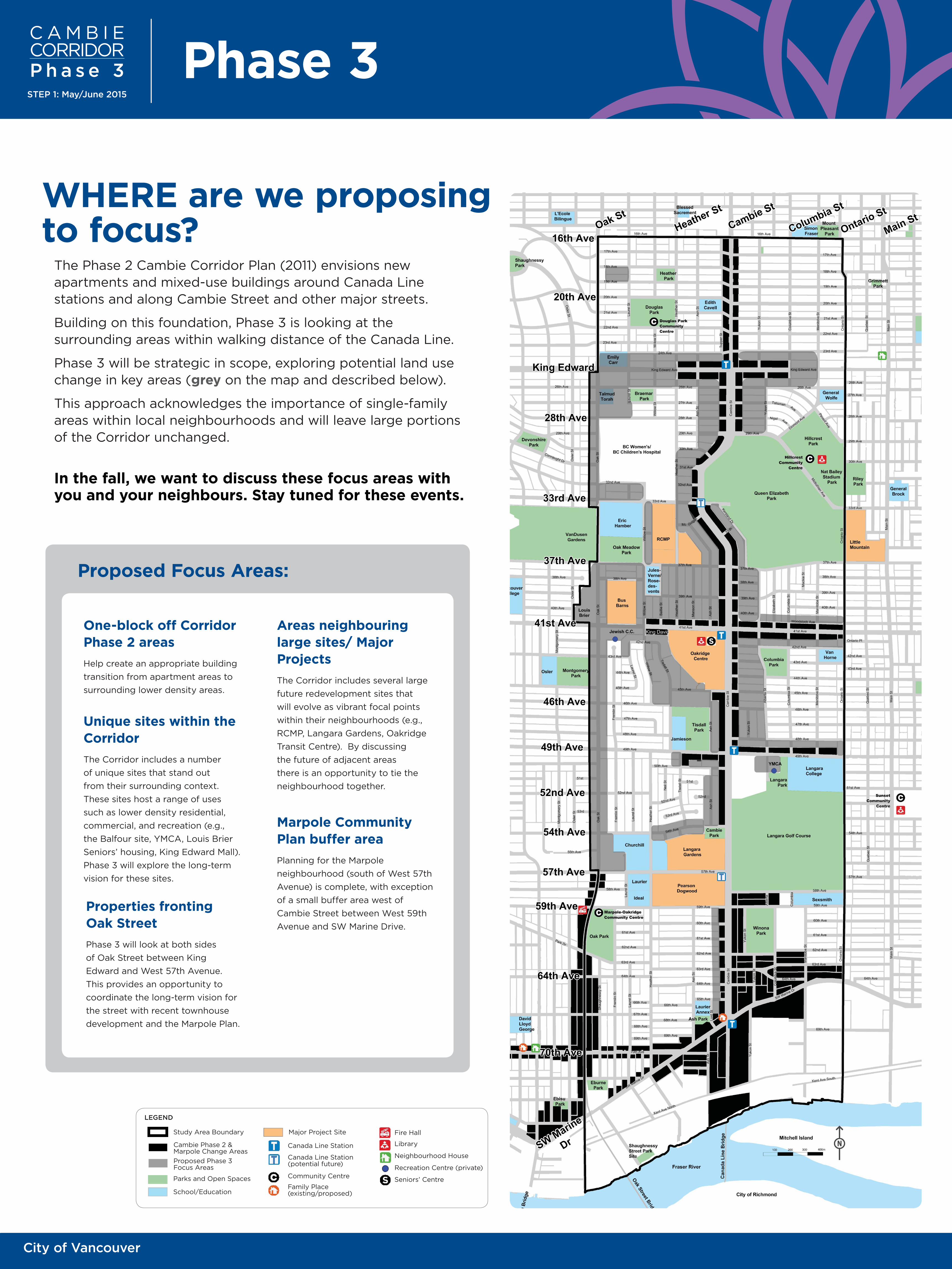
WHERE are we proposing to focus?
One-block off Corridor Phase 2 areas
Help create an appropriate building
transition from apartment areas to
surrounding lower density areas.
Areas neighbouring large sites/ Major Projects
The Corridor includes several large
future redevelopment sites that
will evolve as vibrant focal points
within their neighbourhoods (e.g.,
RCMP, Langara Gardens, Oakridge
Transit Centre). By discussing
the future of adjacent areas
there is an opportunity to tie the
neighbourhood together.
Unique sites within the Corridor
The Corridor includes a number
of unique sites that stand out
from their surrounding context.
These sites host a range of uses
such as lower density residential,
commercial, and recreation (e.g.,
the Balfour site, YMCA, Louis Brier
Seniors’ housing, King Edward Mall).
Phase 3 will explore the long-term
vision for these sites.
Marpole Community Plan buffer area
Planning for the Marpole
neighbourhood (south of West 57th
Avenue) is complete, with exception
of a small buffer area west of
Cambie Street between West 59th
Avenue and SW Marine Drive.
Proposed Focus Areas:
Properties fronting Oak Street
Phase 3 will look at both sides
of Oak Street between King
Edward and West 57th Avenue.
This provides an opportunity to
coordinate the long-term vision for
the street with recent townhouse
development and the Marpole Plan.
The Phase 2 Cambie Corridor Plan (2011) envisions new apartments and mixed-use buildings around Canada Line stations and along Cambie Street and other major streets.
Building on this foundation, Phase 3 is looking at the surrounding areas within walking distance of the Canada Line.
Phase 3 will be strategic in scope, exploring potential land use change in key areas (grey on the map and described below).
This approach acknowledges the importance of single-family areas within local neighbourhoods and will leave large portions of the Corridor unchanged.
In the fall, we want to discuss these focus areas with you and your neighbours. Stay tuned for these events.
Phase 3
Study Area Boundary
LEGEND
Parks and Open Spaces
School/Education
Major Project Site
Cambie Phase 2 & Marpole Change Areas
Proposed Phase 3Focus Areas
Canada Line Station
Canada Line Station (potential future)
Community Centre
Family Place (existing/proposed)
Fire Hall
Library
Neighbourhood House
Recreation Centre (private)
Seniors’ Centre
C A M B I ECORRIDORP h a s e 3STEP 1: May/June 2015
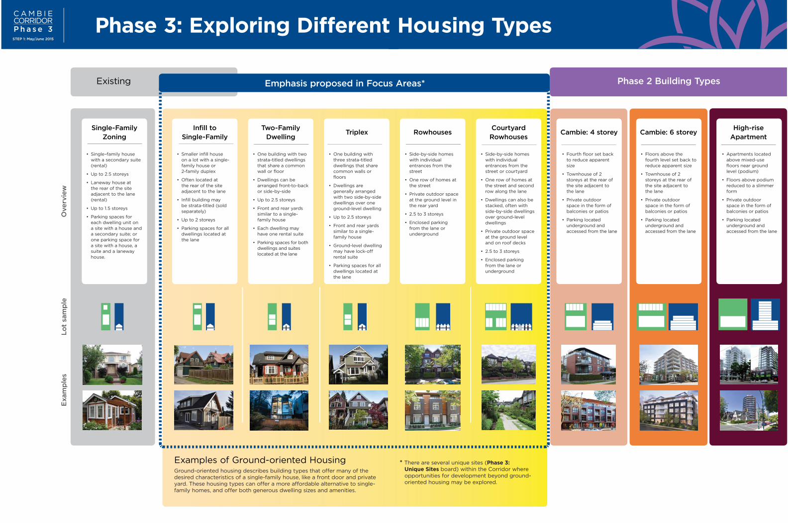
Phase 3: Exploring Different Housing Types
Single-Family Zoning
Infill to Single-Family
Two-Family Dwelling
Triplex RowhousesCourtyard Rowhouses
Cambie: 4 storey Cambie: 6 storeyHigh-rise
Apartment
• Apartments located above mixed-use floors near ground level (podium)
• Floors above podium reduced to a slimmer form
• Private outdoor space in the form of balconies or patios
• Parking located underground and accessed from the lane
• Floors above the fourth level set back to reduce apparent size
• Townhouse of 2 storeys at the rear of the site adjacent to the lane
• Private outdoor space in the form of balconies or patios
• Parking located underground and accessed from the lane
• Fourth floor set back to reduce apparent size
• Townhouse of 2 storeys at the rear of the site adjacent to the lane
• Private outdoor space in the form of balconies or patios
• Parking located underground and accessed from the lane
• Side-by-side homes with individual entrances from the street or courtyard
• One row of homes at the street and second row along the lane
• Dwellings can also be stacked, often with side-by-side dwellings over ground-level dwellings
• Private outdoor space at the ground level and on roof decks
• 2.5 to 3 storeys
• Enclosed parking from the lane or underground
• Side-by-side homes with individual entrances from the street
• One row of homes at the street
• Private outdoor space at the ground level in the rear yard
• 2.5 to 3 storeys
• Enclosed parking from the lane or underground
• One building with three strata-titled dwellings that share common walls or floors
• Dwellings are generally arranged with two side-by-side dwellings over one ground-level dwelling
• Up to 2.5 storeys
• Front and rear yards similar to a single-family house
• Ground-level dwelling may have lock-off rental suite
• Parking spaces for all dwellings located at the lane
• One building with two strata-titled dwellings that share a common wall or floor
• Dwellings can be arranged front-to-back or side-by-side
• Up to 2.5 storeys
• Front and rear yards similar to a single-family house
• Each dwelling may have one rental suite
• Parking spaces for both dwellings and suites located at the lane
• Smaller infill house on a lot with a single-family house or 2-family duplex
• Often located at the rear of the site adjacent to the lane
• Infill building may be strata-titled (sold separately)
• Up to 2 storeys
• Parking spaces for all dwellings located at the lane
• Single–family house with a secondary suite (rental)
• Up to 2.5 storeys
• Laneway house at the rear of the site adjacent to the lane (rental)
• Up to 1.5 storeys
• Parking spaces for each dwelling unit on a site with a house and a secondary suite; or one parking space for a site with a house, a suite and a laneway house.
Emphasis proposed in Focus Areas* Phase 2 Building TypesExisting
Examples of Ground-oriented HousingGround-oriented housing describes building types that offer many of the desired characteristics of a single-family house, like a front door and private yard. These housing types can offer a more affordable alternative to single-family homes, and offer both generous dwelling sizes and amenities.
Exam
ple
sL
ot
sam
ple
Overv
iew
* There are several unique sites (Phase 3: Unique Sites board) within the Corridor where opportunities for development beyond ground-oriented housing may be explored.
City of Vancouver vancouver.ca/cambiecorridor
C A M B I ECORRIDORP h a s e 3STEP 1: May/June 2015
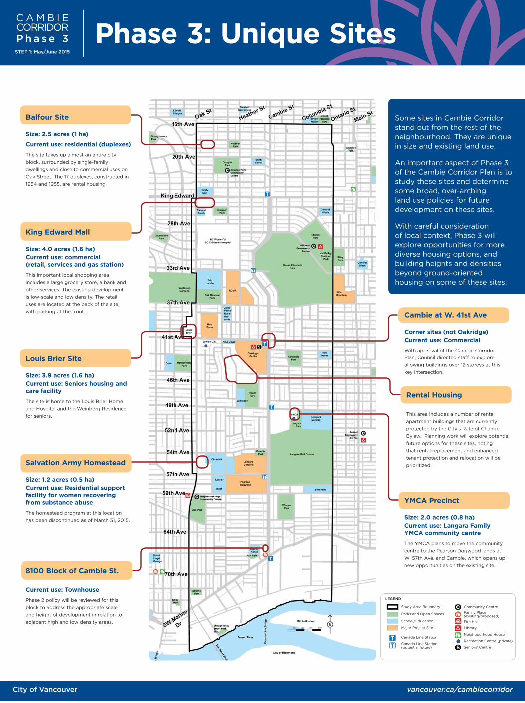
Phase 3: Unique Sites
Some sites in Cambie Corridor stand out from the rest of the neighbourhood. They are unique in size and existing land use.
An important aspect of Phase 3 of the Cambie Corridor Plan is to study these sites and determine some broad, over-arching land use policies for future development on these sites.
With careful consideration of local context, Phase 3 will explore opportunities for more diverse housing options, and building heights and densities beyond ground-oriented housing on some of these sites.
Balfour Site
Size: 2.5 acres (1 ha)
Current use: residential (duplexes)
The site takes up almost an entire city
block, surrounded by single-family
dwellings and close to commercial uses on
Oak Street. The 17 duplexes, constructed in
1954 and 1955, are rental housing.
King Edward Mall
Size: 4.0 acres (1.6 ha)Current use: commercial(retail, services and gas station)
This important local shopping area
includes a large grocery store, a bank and
other services. The existing development
is low-scale and low density. The retail
uses are located at the back of the site,
with parking at the front.
YMCA Precinct
Size: 2.0 acres (0.8 ha) Current use: Langara Family YMCA community centre
The YMCA plans to move the community
centre to the Pearson Dogwood lands at
W. 57th Ave. and Cambie, which opens up
new opportunities on the existing site.
Salvation Army Homestead
Size: 1.2 acres (0.5 ha)Current use: Residential support facility for women recovering from substance abuse
The homestead program at this location
has been discontinued as of March 31, 2015.
Cambie at W. 41st Ave
Corner sites (not Oakridge) Current use: Commercial
With approval of the Cambie Corridor
Plan, Council directed staff to explore
allowing buildings over 12 storeys at this
key intersection.
8100 Block of Cambie St.
Current use: Townhouse
Phase 2 policy will be reviewed for this
block to address the appropriate scale
and height of development in relation to
adjacent high and low density areas.
Rental Housing
This area includes a number of rental
apartment buildings that are currently
protected by the City’s Rate of Change
Bylaw. Planning work will explore potential
future options for these sites, noting
that rental replacement and enhanced
tenant protection and relocation will be
prioritized.
Louis Brier Site
Size: 3.9 acres (1.6 ha)Current use: Seniors housing and care facility
The site is home to the Louis Brier Home
and Hospital and the Weinberg Residence
for seniors.
Study Area Boundary
LEGEND
Parks and Open Spaces
School/Education
Major Project Site
Canada Line Station
Canada Line Station (potential future)
Community Centre
Family Place (existing/proposed)
Fire Hall
Library
Neighbourhood House
Recreation Centre (private)
Seniors’ Centre
City of Vancouver vancouver.ca/cambiecorridor
C A M B I ECORRIDORP h a s e 3STEP 1: May/June 2015
Phase 3
Building a Complete Community
Public Benefits Strategy Public Realm Plan
Interim Public Benefits Strategy (Cambie Corridor Plan, 2011)
Public amenities and services, such as community centres, social facilities, childcare, parks, transportation and public safety infrastructure play an important role in creating and maintaining a liveable community.
Cambie Corridor has many public amenities - some are getting old and are in need of renewal, others need to be improved to accommodate the growing population in the Corridor.
• affordable housing
• childcare
• parks, plazas and other public realm improvements
• civic facilities
• non-profit and cultural space
As the Corridor develops, public benefits (in no particular order) will be sought in the form of:
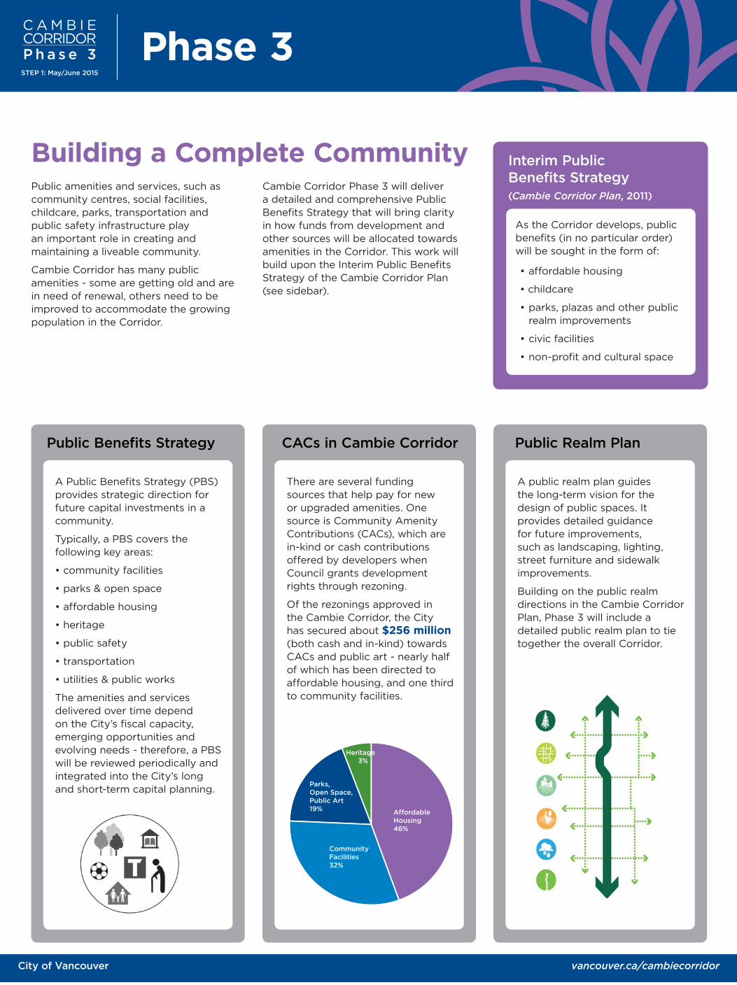
CACs in Cambie Corridor
English, 61.3%Affordable Housing 46%
CommunityFacilities 32%
Parks, Open Space,Public Art 19%
Heritage 3%
A Public Benefits Strategy (PBS) provides strategic direction for future capital investments in a community.
Typically, a PBS covers the following key areas:
• community facilities
• parks & open space
• affordable housing
• heritage
• public safety
• transportation
• utilities & public works
The amenities and services delivered over time depend on the City’s fiscal capacity, emerging opportunities and evolving needs - therefore, a PBS will be reviewed periodically and integrated into the City’s long and short-term capital planning.
There are several funding sources that help pay for new or upgraded amenities. One source is Community Amenity Contributions (CACs), which are in-kind or cash contributions offered by developers when Council grants development rights through rezoning.
Of the rezonings approved in the Cambie Corridor, the City has secured about $256 million (both cash and in-kind) towards CACs and public art - nearly half of which has been directed to affordable housing, and one third to community facilities.
A public realm plan guides the long-term vision for the design of public spaces. It provides detailed guidance for future improvements, such as landscaping, lighting, street furniture and sidewalk improvements.
Building on the public realm directions in the Cambie Corridor Plan, Phase 3 will include a detailed public realm plan to tie together the overall Corridor.
Cambie Corridor Phase 3 will deliver a detailed and comprehensive Public Benefits Strategy that will bring clarity in how funds from development and other sources will be allocated towards amenities in the Corridor. This work will build upon the Interim Public Benefits Strategy of the Cambie Corridor Plan (see sidebar).