cambridge local plan - cambridge city council plan... · foreword cambridge local plan 2006 5...
TRANSCRIPT

CAMBRIDGELOCAL PLANJuly 2006


CAMBRIDGE CITY COUNCILLOCAL PLAN 2006
Printed on recycled paper: 9lives. Please recycle.


FOREWORD CAMBRIDGE LOCAL PLAN 2006 5
FOREWORDThis Local Plan sets out the City Council's policies about how the demands of growth and changecan be met without compromising the many qualities that make Cambridge such a wonderful place.Our City is set to grow rapidly – by up to 30% in population over the next 15 years – and those of uswho live and work here will experience changes in our physical surroundings and our sense of thecommunity in which we live. We will be joined by thousands of new citizens, and many newbusinesses and other organisations, who will help to shape the physical character and the spirit of theCity.
This growth will bring with it many benefits – a better chance for our key workers and young peopleto find an affordable home in the City; the prospect of enhanced economic prosperity for us all; theprovision of new cultural, shopping and leisure services; and opportunities to create new andimproved green spaces within the urban framework and linking to the countryside beyond.
But change can also be a worrying prospect. If we are to feel positive and confident about the future,we need to feel that change is being properly managed and that, as citizens, we can influence themanagement process. Your involvement in the implementation of the plan will greatly assist the CityCouncil to achieve this aim


CONTENTS CAMBRIDGE LOCAL PLAN 2006 7
CONTENTSFOREWORD 5
INDEX OF POLICIES 9
POLICY CHAPTERS1 INTRODUCTION 132 VISION AND STRATEGY 173 DESIGNING CAMBRIDGE 214 CONSERVING CAMBRIDGE 335 LIVING IN CAMBRIDGE 476 ENJOYING CAMBRIDGE 597 WORKING AND STUDYING IN CAMBRIDGE 678 CONNECTING AND SERVICING CAMBRIDGE 859 AREAS OF MAJOR CHANGE 9910 IMPLEMENTATION 121
APPENDICESOPEN SPACE AND RECREATION STANDARDS 127CRITERIA TO ASSESS OPEN SPACE 131CAR PARKING STANDARDS 133CYCLE PARKING STANDARDS 139DESIGNATIONS SCHEDULE 143PROPOSALS SCHEDULE 147BIBLIOGRAPHY 153GLOSSARY 157
The maps within this document are covered by the following copyright statement:"This map is reproduced from Ordnance Survey material with the permission of Ordnance Surveyon behalf of the Controller of Her Majesty's Stationery Office © Crowncopyright.Unauthorised reproduction infringes Crown copyright and may lead to prosecution or civil proceedings."Cambridge City Council (Licence No.100019730) 2007.


INDEX OF POLICIES CAMBRIDGE LOCAL PLAN 2006 9
INDEX OF POLICIESPOLICY NAME POLICY/PAGE NUMBER
3 DESIGNING CAMBRIDGESustainable DevelopmentSustainable Development 3/1 21
Promoting Design QualitySetting of the City 3/2 22Safeguarding Environmental Character 3/3 23Responding to Context 3/4 23Mixed use Development 3/5 24Ensuring Coordinated Development 3/6 24Creating Successful Places 3/7 25Open Space and Recreation Provision Through New Development 3/8 26Watercourses and Other Bodies of Water 3/9 27Sub-Division of Existing Plots 3/10 28The Design of External Spaces 3/11 28The Design of New Buildings 3/12 29Tall Buildings and the Skyline 3/13 30Extending Buildings 3/14 31Shopfronts and Signage 3/15 31
4 CONSERVING CAMBRIDGEProtecting the Natural EnvironmentGreen Belt 4/1 33Protection of Open Space 4/2 34Safeguarding Features of Amenity or Nature Conservation Value 4/3 35Trees 4/4 36Protection of Sites of National Nature Conservation Importance 4/5 37Protection of Sites of Local Nature Conservation Importance 4/6 37Species Protection 4/7 38Local Biodiversity Action Plans 4/8 39
Protecting the Built EnvironmentScheduled Ancient Monuments/Archeological Areas 4/9 40Listed Buildings 4/10 40Conservation Areas 4/11 41Buildings of Local Interest 4/12 42
Pollution and Flood ProtectionPollution and Amenity 4/13 43Air Quality Management Areas 4/14 44Lighting 4/15 44Development and Flooding 4/16 45
POLICY NAME POLICY/PAGE NUMBER
5 LIVING IN CAMBRIDGEHousingHousing Provision 5/1 47Conversion of Large Properties 5/2 48Housing Lost to Other Uses 5/3 49Loss of Housing 5/4 49Meeting Housing Needs 5/5 50Meeting Housing Needs from Employment Development 5/6 52Supported Housing/Housing in Multiple Occupation 5/7 52Travellers 5/8 53Housing for People with Disabilities 5/9 54Dwelling Mix 5/10 54
Community FacilitiesProtection of Existing Facilities 5/11 54New Community Facilities 5/12 56Community Facilities in the Areas of Major Change 5/13 57Provision of Community Facilities Through New Development 5/14 57Addenbrooke's 5/15 58
6 ENJOYING CAMBRIDGELeisureProtection of Leisure Facilities 6/1 59New Leisure Facilities 6/2 59
TourismTourist Accommodation 6/3 60Visitor Attractions 6/4 61
ShoppingShopping Development in the City Centre 6/5 62Change of Use in the City Centre 6/6 62Shopping Development and Change of Use in District and Local Centres 6/7 63Convenience Shopping 6/8 64Retail Warehouses 6/9 65Food and Drink Outlets 6/10 65
10 CAMBRIDGE LOCAL PLAN 2006 INDEX OF POLICIES

INDEX OF POLICIES CAMBRIDGE LOCAL PLAN 2006 11
POLICY NAME POLICY/PAGE NUMBER
7 WORKING AND STUDYING IN CAMBRIDGEEmploymentEmployment Provision 7/1 68Selective Management of the Economy 7/2 70Protection of Industrial and Storage Space 7/3 73Promotion of Cluster Development 7/4 74
Higher and Further EducationFaculty Development in the Central Area, University of Cambridge 7/5 75West Cambridge, South of Madingley Road 7/6 76College and University of Cambridge Staff and Student Housing 7/7 77Anglia Ruskin University East Road Campus 7/8 78Student Hostels for Anglia Ruskin University 7/9 79Speculative Student Hostel Accommodation 7/10 82Language Schools 7/11 82
8 CONNECTING AND SERVICING CAMBRIDGETransportSpatial Location of Development 8/1 86Transport Impact 8/2 86Mitigating Measures 8/3 86Walking and Cycling Accessibility 8/4 87Pedestrian and Cycle Network 8/5 87Cycle Parking 8/6 88Public Transport Accessibility 8/7 88Land for Public Transport 8/8 89Commercial Vehicles and Servicing 8/9 90Off-Street Car Parking 8/10 90New Roads 8/11 90
Cambridge AirportCambridge Airport 8/12 91Cambridge Airport Public Safety Zone 8/13 92
TelecommunicationsTelecommunications Development 8/14 92Mullard Radio Astronomy Observatory, Lord's Bridge 8/15 93
Energy ResourcesRenewable Energy in Major New Developments 8/16 94Renewable Energy 8/17 95
Water, Sewerage and Drainage InfrastructureWater, Sewerage and Drainage Infrastructure 8/18 96

12 CAMBRIDGE LOCAL PLAN 2006 INDEX OF POLICIES
POLICY NAME POLICY/PAGE NUMBER
9 AREAS OF MAJOR CHANGEFurther Policy/Guidance for the Development of Areas of Major Change 9/1 99Phasing of Areas of Major Change 9/2 101Development in the Urban Extensions 9/3 103East Cambridge 9/4 104Southern Fringe 9/5 106Northern Fringe 9/6 110Land between Madingley Road and Huntingdon Road 9/7 114Land between Huntingdon Road and Histon Road 9/8 117Station Area 9/9 118
10 IMPLEMENTATIONInfrastructure Improvements 10/1 122Monitoring and Review 10/2 124

INTRODUCTION CAMBRIDGE LOCAL PLAN 2006 CHAPTER ONE 13
INTRODUCTIONThe Cambridge Local Plan sets out policies and proposals forfuture development and land use to 20161. It sets out a visionfor Cambridge and objectives for achievement. It provides ameans of guiding change over long periods of time. Planningdecisions will be made in accordance with it.
The Local Plan: interprets national and regional planning policies and relates
them to Cambridge; provides a framework of policies and proposals against which
planning applications can be assessed; will enable infrastructure providers to plan for the future; and brings planning issues before the public for debate.
Context
The Local Plan must direct the growth and change of a dynamicCity with an outstanding and sensitive environment. Cambridgeis an important centre for employment, services, government,healthcare and shopping, and is nationally and internationallyimportant for its higher education, knowledge-based industriesand tourism. Located within an hour of London and 30 minutesof Stansted, it is centrally located on the main transport routeswithin the East of England Region.
Cambridgeshire has one of the fastest growing economies andpopulations in Britain. In the past much of this growth wasdirected to the villages beyond the Green Belt, resulting in agrowth of commuting by car to Cambridge, and congestionand pollution in the cramped road network of the City. A lack oflocal housing that people can afford has reinforced these trendsand forced people to live further away from Cambridge, a Citywhich has almost twice as many jobs as residents in work.
National Government gives comprehensive general guidanceon all aspects of development, through its Planning PolicyGuidance notes (PPGs), and newer Planning Policy Statements(PPSs), Circulars and other advice. This Plan has not sought toreproduce or paraphrase this guidance, which will remain amaterial consideration in planning decisions.
Regional Planning Guidance for East Anglia (RPG6) waspublished in November 2000. It sets out a strategy for thefuture of the Cambridge Sub-region, which is carried forwardinto the Structure Plan. RPG6 is under review. The new RPG2 onits publication will replace the Structure Plan for Cambridgeshireand Peterborough.
1.1
1.2
1.3
1.4
1.5
1 The time period covered by the Local Plan is from 1st July 1999 to 1st July2016. 2 To be called a Regional Spatial Strategy.

14 CHAPTER ONE CAMBRIDGE LOCAL PLAN 2006 INTRODUCTION
The broad vision and strategy for the future of Cambridge is setby the Cambridgeshire and Peterborough Structure Plan. TheLocal Plan is required to be in conformity with the provisions ofthe Structure Plan.
The Structure Plan requires that 12,500 homes be provided inCambridge between 1999 and 2016, of which at least 65%should be built on previously developed land. Provision is to bemade for 6,500 homes within the built up area of Cambridgeand 6,000 on the edge of Cambridge on land to be releasedfrom the Green Belt. A Green Belt will be maintained aroundCambridge to define the extent of urban growth.
The urban extensions to Cambridge are to be the subject ofMasterplans to ensure their proper planning and coordination.Economic growth will be supported in the Cambridge Sub-region through the expansion of high technology andknowledge-based industry and through the selectivemanagement of the economy to prevent employmentdevelopment which does not need to be close to Cambridge.
The City Council will work closely with Cambridgeshire CountyCouncil, South Cambridgeshire District Council and otherbodies in the Cambridge Sub-region to deliver a sustainablefuture for Cambridge. The County Council is the Structure PlanAuthority and are also responsible for waste, transport andeducation. Many of the proposed urban extension sites stepacross the administrative boundary between the City and SouthCambridgeshire and a coordinated approach to these sites andto the setting of new Green Belt boundaries will be taken.
A Sustainable Plan
The Cambridge Local Plan aims to improve our quality of lifewithout harming that of future generations. This is calledsustainable development and the policies in the Plan areworking to achieve this goal. Relevant economic, social andenvironmental issues are closely linked in the national strategyfor sustainable development which has four objectives: social progress which recognises the needs of everyone; effective protection of the environment; prudent use of natural resources; and maintenance of high and stable levels of economic growth
and employment.
The Cambridge Local Plan and the planning system has afundamental role to play in achieving the land use planningaspects of sustainable development. Account will be taken of thefollowing sustainability criteria in making planning decisions: making the best and most efficient use of land and buildings; creating sustainable patterns of development by relating new
development to public transport nodes and local facilities; encouraging mixed use development, incorporating housing,
retail and business uses and new leisure and recreation opportunities;
1.6
1.7
1.8
1.9
1.10
1.11

INTRODUCTION CAMBRIDGE LOCAL PLAN 2006 CHAPTER ONE 15
protecting and promoting biodiversity in development proposals; and phasing the release of development sites.
A Sustainability Appraisal has been carried out to check howwell the Cambridge Local Plan supports relevant sustainabledevelopment objectives.
The Sustainability Appraisal was undertaken independently byLevett-Therivel, a leading consultancy in the field of sustainabledevelopment. Guidance was given during the development ofpolicy to ensure that the Plan as written contributes significantlyto the achievement of a sustainable future for Cambridge.Policies were appraised against six sustainable developmentobjectives and a written commentary added. Changes havebeen made to plan policies in response to appraisal feedback.The Sustainability Appraisal of the Cambridge Local Plan ispublished separately. It does not form part of the Local Plan.
Monitoring
The monitoring of development is critical in the developmentand implementation of a policy framework to guide changeover long periods of time. As far as is possible the policies inthe Local Plan will facilitate monitoring and review. Monitoringwill provide the information necessary for the City Council toreview the Local Plan and to keep it up to date.
The start date of the Local Plan and the baseline date formonitoring is the situation as at the 1st July 1999. Regularmonitoring reports will be produced detailing the key results.
Community Strategy
There are many factors within Cambridge that have a bearingon planning policies and decision-making. The CommunityStrategy will help to deliver the Council's and its partners'objectives for Cambridge. The Local Plan will achieve thephysical and spatial objectives of the Community Strategy.
The Community Strategy has been implemented by apartnership between the City Council, statutory organisationsand the community. This is called the Local StrategicPartnership.
The Status Of The Local Plan
This Local Plan replaces the Cambridge Local Plan 1996 andforms the most detailed part of the Development Plan forCambridge. The other parts are the Cambridgeshire andPeterborough Structure Plan, which sets out policies for theCounty, Peterborough and the Cambridge Sub-region, theCambridgeshire Aggregates (Minerals) Local Plan and the
1.12
1.13
1.14
1.15
1.16
1.17
1.18
16 CHAPTER ONE CAMBRIDGE LOCAL PLAN 2006 INTRODUCTION
Cambridgeshire and Peterborough Waste Local Plan. Accountwill also be taken of the Cambridgeshire Local Transport Plan.Together these plans form the framework for determiningplanning applications in Cambridge.
Using The Local Plan
The Plan is divided into a number of chapters each containingnumbered policies in bold text and their justification. Eachchapter has the following parts: Objectives: what the Plan is intended to achieve in broad
terms. Policies: which types of development will and will not be
permitted or supported.
Chapter 10 sets out how the policies of the Plan will beimplemented. Site specific proposals are listed in the Schedule ofProposals and are shown on the Proposals Map. Where there isany contradiction between the Proposals Map and the writtentext, the latter will take precedence.
When a policy states that a certain type of development will bepermitted it should also be understood that other types ofdevelopment are likely to be refused. When a policy calls forsomething to be demonstrated this will require action on the partof the applicant to inform the decision maker. If the requiredaction is not taken to an appropriate standard, development islikely to be refused. For the avoidance of doubt, the final resultof calculations arising from the application of policies andguidance should always be rounded to the nearest wholenumber.
Existing Supplementary Planning Guidance (SPG), and newSupplementary Planning Documents (SPD), will provide detailedguidance on specific topics to ensure that development takesplace in accordance with the objectives and policies of the LocalPlan and other relevant parts of the Development Plan. SPD willbe produced in accordance with a timetable to be set out in theLocal Development Scheme. SPD will be updated more regularlythan the Plan as a whole, making them more able to respond tochanging circumstances. There are two types of SPD, which are: issue based SPD for subjects which require detailed
requirements to be listed to guide development proposals suchas guidance on the provision of affordable housing; and area based SPD for particular sites and areas that are
proposed for a significant amount of development.
In general, the policies for particular uses and sites do notduplicate the content of other policies in the Local Plan or otherparts of the Development Plan.
In using the Local Plan it is essential that its policies andproposals are not read in isolation, they must be considered asa whole and together with policies and proposals elsewhere inthe Development Plan.
1.19
1.20
1.21
1.22
1.23
VISION AND STRATEGY CAMBRIDGE LOCAL PLAN 2006 CHAPTER TWO 17
VISION AND STRATEGYThe Vision for Cambridge
The vision for Cambridge is of a compact, dynamic City with athriving historic core surrounded by attractive and accessiblegreenspaces. It will continue to develop as a centre of excellenceand world leader in the fields of higher education and research,and it will foster the dynamism, prosperity and further expansion ofthe knowledge-based economy. It will also grow in importance asa Sub-regional centre for a wide range of services. The Local Planfor Cambridge seeks to guide and facilitate growth in a sensitiveand sustainable manner, ensuring that the high environmentalquality of the City is protected and enhanced and that futuredevelopments offer a full range of opportunities to all its citizens.
The Strategy
The Local Plan sets out a strategy for delivering this vision whichhas a number of components, all of which contribute tosustainability:
The promotion of the highest possible standard of design in new development (Chapter 3: Designing Cambridge).
The careful conservation and enhancement of historic areas and greenspaces (Chapter 4: Conserving Cambridge).
The consolidation and improvement of existing residential communities, the promotion of new housing and community facilities in the growth areas, and a greater emphasis on meeting diverse housing needs (Chapter 5: Livingin Cambridge).
The protection and enhancement of leisure and shopping facilities (Chapter 6: Enjoying Cambridge).
The promotion of employment growth in sustainable and accessible locations to support the future expansion of education, research, knowledge-based industries and essential services (Chapter 7: Working and Studying in Cambridge).
The provision of appropriate infrastructure, in particular transportinfrastructure, to support new developments and promote more sustainable living patterns (Chapter 8: Connecting andServicing Cambridge).
Planning for the long term sustainable growth of the City (Chapter 9: Areas of Major Change).
A coordinated and responsive approach to the implementation of the various components of the strategy(Chapter 10: Implementation).
2.1
2.2

18 CHAPTER TWO CAMBRIDGE LOCAL PLAN 2006 VISION AND STRATEGY
The Spatial Strategy
The main spatial components of this strategy are:
A thriving and accessible historic core.
The historic core and the surrounding central areas will beenhanced as the focus for civic activities, the two Universities,shopping, leisure and City Centre living. Streets and public spacesin the City Centre will be enhanced and made more friendly to thepedestrian as access by the private car is progressivelydiscouraged by physical barriers and demand managementmeasures. The accessibility of the City Centre for pedestrians,cyclists, and users of taxis and public transport will be improved,and special consideration will be given to the needs of disabledpeople. The attractiveness of the City Centre as a Sub-regionalshopping destination will be enhanced by the implementation ofthe Grand Arcade shopping development on St Andrew's Street,and other redevelopments at Bradwell's Court and around theGrafton Centre.
The regeneration of the Station Area as a mixed use City districtbuilt around an enhanced transport interchange.
The Station Area will be regenerated with high density residentialand commercial development which will support a dramaticimprovement to the quality of the transport interchange, improvingthe facilities for pedestrians, cyclists, buses, taxis, and drop-off,whilst consolidating but not increasing the amount of car parkingfor rail users. The street environment will be enhanced by localretail, leisure and community facilities, and a new 'gateway' toCambridge will be created to provide an appropriate arrival pointat a major historic city.
The consolidation or development of four peripheral mixed usecentres to the north, south, west and east of the City as a focus forfuture employment and residential expansion, connected to eachother and to the City Centre by high quality public transport.
To the north of the City, a high density mixed use development isproposed around a new railway station and transport interchangeat Chesterton Sidings (in South Cambridgeshire District Council)and adjoining land within the City. This will require the relocationof the waste water treatment works to a new site.
To the south of the City, land is to be removed from the GreenBelt to facilitate an expansion of Addenbrooke's Hospital as aregional hospital and a centre of excellence for associatedbiomedical and biotechnology research and developmentactivities, related higher education or research institutes. Thisexpansion will be supported by improvements to transportinfrastructure on the south side of the City including high qualitypublic transport. The new access road linking the hospital toHauxton Road will also provide access to new residentialcommunities on land removed from the Green Belt to the eastand south of Trumpington.
2.3
2.4
2.5
2.6
2.7

VISION AND STRATEGY CAMBRIDGE LOCAL PLAN 2006 CHAPTER TWO 19
Madingley R oad
Huntingdon Road
Histon R
oad
Milton R
oad
New market Road
Hills Road
Trum
ping
ton
Roa
d
Shel ford Road
Hau
xto
n R
oad
M11
A14
A14
Barto
n Ro
ad
BARTON
COTON
GIRTON
MILTON
HISTON
TEVERSHAM
CHERRYHINTON
TRUMPINGTON
GREATSHELFORD
ROMSEY
CHESTERTON
NEWNHAM
River Cam
Existing & Potential Railway Stations
City Boundary
City Centre
Corridor Open Space
Existing Urban Areas
Area of Major Change
Figure 1 is intended to assist understanding of the main spatial components of the Plan strategy, although it does nothave a formal status like the Proposals Map.
Figure 1: A Schematic Diagram of the Main Spatial Components of the Strategy.
© Crown Copyright (Licence No. 100019730)
20 CHAPTER TWO CAMBRIDGE LOCAL PLAN 2006 VISION AND STRATEGY
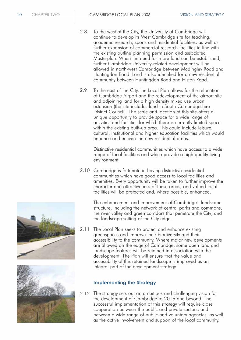
To the west of the City, the University of Cambridge willcontinue to develop its West Cambridge site for teaching,academic research, sports and residential facilities, as well asfurther expansion of commercial research facilities in line withthe existing outline planning permission and associatedMasterplan. When the need for more land can be established,further Cambridge University-related development will beallowed in north-west Cambridge between Madingley Road andHuntingdon Road. Land is also identified for a new residentialcommunity between Huntingdon Road and Histon Road.
To the east of the City, the Local Plan allows for the relocationof Cambridge Airport and the redevelopment of the airport siteand adjoining land for a high density mixed use urbanextension (the site includes land in South CambridgeshireDistrict Council). The scale and location of this site offers aunique opportunity to provide space for a wide range ofactivities and facilities for which there is currently limited spacewithin the existing built-up area. This could include leisure,cultural, institutional and higher education facilities which wouldenhance and enliven the new residential areas.
Distinctive residential communities which have access to a widerange of local facilities and which provide a high quality livingenvironment.
Cambridge is fortunate in having distinctive residentialcommunities which have good access to local facilities andamenities. Every opportunity will be taken to further improve thecharacter and attractiveness of these areas, and valued localfacilities will be protected and, where possible, enhanced.
The enhancement and improvement of Cambridge's landscapestructure, including the network of central parks and commons,the river valley and green corridors that penetrate the City, andthe landscape setting of the City edge.
The Local Plan seeks to protect and enhance existinggreenspaces and improve their biodiversity and theiraccessibility to the community. Where major new developmentsare allowed on the edge of Cambridge, some open land andlandscape features will be retained in association with thedevelopment. The Plan will ensure that the value andaccessibility of this retained landscape is improved as anintegral part of the development strategy.
Implementing the Strategy
The strategy sets out an ambitious and challenging vision forthe development of Cambridge to 2016 and beyond. Thesuccessful implementation of this strategy will require closecooperation between the public and private sectors, andbetween a wide range of public and voluntary agencies, as wellas the active involvement and support of the local community.
2.8
2.9
2.10
2.11
2.12
DESIGNING CAMBRIDGE CAMBRIDGE LOCAL PLAN 2006 CHAPTER THREE 21
DESIGNING CAMBRIDGEObjectives
1. To ensure the City develops in an integrated and sustainable manner.
2. To create new and distinctive communities which enhance the special character of the City, and meet the needs of its residents and users.
3. To ensure that development is of the highest design quality, and respects, safeguards and enhances the unique characterof the City's urban and open areas.
Introduction
This chapter contains policies relating to sustainabledevelopment and promoting design quality in newdevelopment.
Cambridge is internationally famous for the quality of its builtenvironment. It has a legacy of historic buildings built over thelast 1,000 years and seeks to enhance this legacy byencouraging innovative new buildings of the highest quality. Anessential part of the character of the City stems from the spacesand grounds around buildings and the important role of treesand other landscape features. Policies relating to the protectionof this character are included in the Conserving CambridgeChapter.
Good urban design is essential if we are to produce attractive,high quality, sustainable places in which people want to live,work and relax.
To help describe the qualities of the City, and to assist inensuring development relates to its local context, a number ofappraisals have been prepared. These range from a City-widelandscape character appraisal to specific Conservation AreaAppraisals and Conservation Plans for major City Centre openspaces.
The Local Plan identifies areas where significant change isanticipated. The vision and policy framework for these areas isset out in the Areas of Major Change Chapter.
Sustainable Development
3/1 Sustainable Development
Development will be permitted if it meets the principles ofsustainability.
3.1
3.2
3.3
3.4
3.5

22 CHAPTER THREE CAMBRIDGE LOCAL PLAN 2006 DESIGNING CAMBRIDGE
Where major development is proposed, developers shouldcomplete the Council's Sustainable Development Checklist andprepare a Sustainability Statement and submit both with theplanning application.
Sustainable development is widely recognised as developmentwhich meets the needs of the present without compromising theability of future generations to meet their own needs. Achievingthis in practice requires environmental issues to be integratedwith economic and social considerations in decisions that aremade during the design, planning and construction phases of adevelopment. The Council has prepared, and adopted asSupplementary Planning Guidance, the Cambridge SustainableDevelopment Guidelines, which provide guidance and sourcesof information and advice on how development proposals canbecome more sustainable, for example by:a. reducing the use of natural resources, including energy and
water throughout the lifecycle of the development;b. making more efficient use of land by prioritising and
maximising the use of brownfield land and building at densities of at least 30 dwellings per hectare net (and higherwhere appropriate);
c. safeguarding and enhancing the historic built environment;d. protecting and enhancing wildlife and the natural
environment;e. minimising waste and pollution to land, air and water
(including noise, vibration and light);f. siting and designing development to reduce the need to
travel, especially by private car; andg. reducing the need for new build by retaining and reusing
existing buildings.
For the purposes of this policy, major development is defined asresidential development of 10 or more dwellings or a site areaof 0.5 hectares or more, or other developments where the newgross floor area is 1,000 square metres or more.
Promoting Design Quality
3/2 Setting of the City
Development will only be permitted on the urban edge if itconserves or enhances the setting and special character ofCambridge and the biodiversity, connectivity and amenity of theurban edge is improved.
The interface between the urban edge and the countryside isimportant to the setting and special character of Cambridge.In general terms the setting and special character ofCambridge is protected from inappropriate development byGreen Belt designation. This policy applies to both Green Beltand areas not designated as Green Belt. Development isexpected to enhance the amenity of the urban edge bothvisually and through improved public accessibility and to add tobiodiversity. Proposals should take account of the character of
3.6
3.7
3.8

DESIGNING CAMBRIDGE CAMBRIDGE LOCAL PLAN 2006 CHAPTER THREE 23
their location by reference to the Historic LandscapeCharacterisation and the Cambridge Landscape CharacterAssessment. Open space must be created and stitched into theexisting open space network and link the urban developmentwith the countryside beyond. Tree and/or hedge planting will berequired in advance of construction works where this will bebeneficial to integrating the development into its surroundings.
3/3 Safeguarding Environmental Character
Development will be permitted if it respects and enhances thedistinctive character and quality of areas identified in theCambridge Landscape Character Assessment.
The historic evolution and character of Cambridge should helpinform, and provide inspiration for, the form of newdevelopment. Reference should be made to the HistoricLandscape Characterisation by Cambridgeshire County Counciland the Cambridge Landscape Character Assessment so thatthey respond to their context and the key characteristics of theirsurroundings. The Character Areas identified are based on theCountryside Commission and English Nature's joint mapCharacter of England: Landscape, Wildlife and NaturalFeatures.
3/4 Responding to Context
Developments will be permitted which demonstrate that theyhave responded to their context and drawn inspiration from thekey characteristics of their surroundings to create distinctiveplaces. Such developments will:a. identify and respond positively to existing features of natural,
historic or local character on and close to the proposed development site;
b. be well connected to, and integrated with, the immediate locality and the wider City; and
c. have used the characteristics of the locality to help inform the siting, massing, design and materials of the proposed development.
Cambridge has many distinctive qualities, which help to definethe identity of the City as a whole and individual character ofareas within the City. This includes its varied palette of buildingmaterials which helps define different character areas within theCity. Development that responds to its context will ensure thecreation of successful integrated development. Regard shouldbe had to underlying archaeology.
A development which responds positively to its context is onewhich will either enhance areas of existing high quality, or willseek to introduce a new and distinctive character to areas ofweaker character.
3.9
3.10
3.11

24 CHAPTER THREE CAMBRIDGE LOCAL PLAN 2006 DESIGNING CAMBRIDGE
Proposals for development should use the CambridgeLandscape Character Assessment, the Conservation AreaAppraisals, the County Historic Environment Record, and the(forthcoming) Historic Landscape Characterisation ofCambridgeshire as starting points to inform the key anddesirable qualities to be retained or enhanced in thedevelopment.
3/5 Mixed Use Development
Developments which include a mix of complementary andcompatible uses will be permitted when:a. residential accommodation can be provided in the
redevelopment of major non-residential sites;b. accommodation for community facilities, retail and leisure
uses can be provided in major residential developments; andc. residential development on streets with a predominantly
non-residential character include some ground floornon-residential floorspace and street frontage.
A mix of uses can help determine how well used a place is, andwhat economic and social activities it will support. Mixed usedevelopment can make the most of opportunities for higherdensity and intensive activity at locations with good access topublic transport. A range of uses close to each other reducesthe need to travel and contributes to environmentalsustainability. A mix of uses may be appropriate at a variety ofscales, within a neighbourhood, street or a building.
Mixed use areas help generate increased pedestrian activity,increase natural surveillance and improve community safety.
It is important that the new urban extensions are designed assustainable, balanced communities, offering not only a place tolive but also the necessary supporting facilities including openspace and retail and leisure developments of an appropriatescale.
3/6 Ensuring Coordinated Development
The development of a site or of part of a site will only bepermitted where it can be demonstrated that due considerationhas been given to safeguarding appropriate futuredevelopments on the remainder of the site or adjacent sites.
Land is a scarce resource and it is important that the best usebe made of it. The release of land for development is necessaryif the City is to continue to be a successful place in which tolive and work. However, if development is poorly planned andis not carried out in a coordinated and comprehensive waythere is a chance that the special character of the City will bedamaged, that infrastructure will not be provided to servedevelopment when it is needed, that provision will not be madefor necessary land uses and that the intention to make
3.13
3.14
3.15
3.16
3.12

DESIGNING CAMBRIDGE CAMBRIDGE LOCAL PLAN 2006 CHAPTER THREE 25
development sustainable will not be met. In somecircumstances, development briefs may be prepared, orMasterplans required, to ensure the proper planning of complexsites.
3/7 Creating Successful Places
Development will be permitted which demonstrates that it isdesigned to provide attractive, high quality, accessible,stimulating, socially inclusive and safe living and workingenvironments. Factors to be taken into account are:a. a comprehensive design approach which achieves good
interrelations and integrations between buildings, routes and spaces;
b. the development of a hierarchy of streets which respond to their levels of use whilst not allowing vehicular traffic to dominate;
c. the creation of attractive built frontages to positively enhancethe townscape where development adjoins public spaces andstreets;
d. the orientation of buildings to overlook public spaces and promote natural surveillance;
e. the provision of active edges onto public spaces by locating entrances and windows of habitable rooms next to the street;
f. the provision of clearly distinct public and private spaces andthe design of such spaces so that they are usable, safe and enjoyable to use;
g. the integration of affordable and supported housing in ways that minimise social exclusion;
h. designs which avoid the threat or perceived threat of crime, avoid insecurity and neglect and contribute to improving community safety;
i. the use of high quality traditional and modern materials, finishes and street furniture suitable to their location and context;
j. a contribution to the improvement and enhancement of the public realm close to the development;
k. provision for the adequate management and maintenance ofdevelopment;
l. the inclusion of public art within new developments; andm.a consideration for the needs of those with disabilities to
ensure places are easily and safely accessible.
High quality public spaces, the public realm, are an importantelement of the overall design quality of the City. Successfulplaces, which include streets, parks, and squares, provide thesetting for everyday life and should be attractive and enjoyableenvironments available to everyone. Places which are wellintegrated with their surroundings and which have identified theopportunities and constraints of the site and its surroundingsand which have responded to them in a positive way will besuccessful. New developments will be expected to improve andenhance the existing public realm as well as create successfulnew spaces.
3.17
26 CHAPTER THREE CAMBRIDGE LOCAL PLAN 2006 DESIGNING CAMBRIDGE
The layout, scale and massing of development, together with thearrangement of its paving, planting, orientation, shelters, signageand street furniture and the way it is overlooked, as well as theroutes which pass through it, will play an important role indetermining how a place functions. These aspects, together withissues such as maintenance and security and creating sociallyinclusive developments will determine how popular, well-usedand successful places will be in the future.
Well planned streets and spaces are fundamental to the creationof good quality development. New development should establisha sense of place and community and should use the movementnetworks to enhance those qualities.
In the making of successful places it is not the street layout butthe relationship of buildings to each other which should beparamount. Ideally the design of new developments should bebased on a network of public spaces rather than a hierarchy ofstreets – the aim being to create layouts in which streets play theirpart but are not dominant elements. Streets should be designedto provide a forum for social interaction as well as facilitatemovement. They should incorporate spaces, which canaccommodate all sorts of activities, formal or informal, plannedor spontaneous.
The design of the network should allow for easy and wellconnected movement by pedestrians, cyclists and public transportto ensure that these modes have priority. This approach willensure that any necessary traffic calming measures are fullyintegrated into the original design proposals.
New development will be expected to address or mitigate anyimpact they may have on community safety and the public realm.
3/8 Open Space and Recreation Provision ThroughNew Development
All residential development will provide public open space andsports facilities in accordance with the Open Space andRecreation Standards. Provision should be on-site as appropriateto the nature and location of development or where the scale ofdevelopment indicates otherwise through commuted payments tothe City Council.
Open space is needed to provide for the outdoor recreationneeds of residents. Its provision will enhance the setting of theCity, and add to its special character, amenity and biodiversity.Many open space uses are not mutually exclusive. For instanceallotment provision will also enhance amenity and biodiversity,and natural greenspaces are valuable for children's play. Theopen space provided could also be used for thestorage/recycling of water to benefit flood protection andencourage sustainable drainage systems. However, open spaceused in this way must be designed to be enjoyed and used by thepublic if it is to count towards meeting the standards.
3.18
3.19
3.20
3.21
3.22
3.23

DESIGNING CAMBRIDGE CAMBRIDGE LOCAL PLAN 2006 CHAPTER THREE 27
3.25
3.26
3.27
3.24 Natural areas and wildlife are of considerable benefit to City livingwhere access to natural greenspaces is often limited. Majordevelopment and urban extensions will include the creation ofmajor new areas of public open space, which should include newhabitats and habitat enhancement. Links between the open spacein the City and the countryside are important and need to bestrengthened. These areas provide opportunity to enhance naturalhabitats and increase public enjoyment.
The Open Space and Recreation Strategy includes a vision foropen space, sport and recreation provision in Cambridge,guidance on type of provision required in different developmentsand schemes for enhancing existing open space. The furtherguidance and associated Masterplans produced for the Areas ofMajor Change will also include guidance for open space provisionin the major urban extensions.
The Open Space and Recreation Standards included in AppendixA give the requirement for different types of open space and sportsfacilities. This includes provision for children and teenagers,playing fields, natural areas, allotments and formal indoor sportsprovision. Some of the open space provided will be outside theCity boundary, and will include accessible countryside areas.Community facilities provided under Policies 5/13 and 5/14 willhelp to meet the need for informal indoor sports provision,providing venues for local community sport and recreation clubs.Where appropriate, other non-residential development, includingmajor centres of employment, may require the provision of openspace. This will be dealt with through masterplanning or designbriefs.
3/9 Watercourses and Other Bodies of Water
Waterside or water-related development will be permitted if it isdemonstrated that it would:a. complement and enhance the waterside setting;b. maintain or improve public access to and along the
waterside;c. maintain and enhance the biodiversity of the watercourses
and other bodies of water and their margins; andd. in the case of recreational development, there is sufficient
capacity to accommodate additional usage of the waterway arising from the development.
The River Cam and other watercourses, as well as a variety ofother water bodies such as the water-filled pits south of Coldham'sLane and Barton Road Pool, are important to the character andform of the City. They are rich in wildlife and offer importantopportunities for leisure and recreation as well as providing adrainage function. It is important that any development proposedalongside these watercourses or that use the watercourses protectsand, where possible, enhances this vital resource.
Increased recreational use of waterways is to be welcomed andencouraged. However, these benefits should only be sought if
3.28
28 CHAPTER THREE CAMBRIDGE LOCAL PLAN 2006 DESIGNING CAMBRIDGE
there will be no significant environmental damage. Existing andforecast usage will be taken into account when assessingproposals, which may lead to additional usage of a waterway. Site3.01 is considered to be suitable for the creation of off-rivermoorings, subject to the nature and scale of development beingconsistent with the continued designation as Green Belt.
3/10 Sub-division of Existing Plots
Residential development within the garden area or curtilage ofexisting properties will not be permitted if it will:a. have a significant adverse impact on the amenities of
neighbouring properties through loss of privacy, loss of light, an overbearing sense of enclosure and the generation of unreasonable levels of traffic or noise nuisance;
b. provide inadequate amenity space, or vehicular access arrangements and parking spaces for the proposed and existing properties;
c. detract from the prevailing character and appearance of the area;
d. adversely affect the setting of Listed Buildings, or buildings or gardens of local interest within or close to the site;
e. adversely affect trees, wildlife features or architectural features of local importance located within or close to the site; and
f. prejudice the comprehensive development of the wider area of which the site forms part.
The provision of new dwellings within the curtilage of existingproperties provides opportunities for additional homes in the City.While new residential accommodation is welcomed, thedevelopment of existing gardens or curtilages needs to be handledcarefully in order to avoid creating new developments, whichadversely affect the amenities of local residents or the character ofthe area.
Gardens represent an important part of the character and amenityvalue of many parts of the City. They can be important visuallywhere they contribute to the street scene or to the openness anddevelopment pattern of an area. They can be important tobiodiversity because they contribute to the network of greenspaceswithin the City, and often they can be important in their own rightas miniature designed landscapes often planned as the setting. Alist of Gardens of Local Interest in the City will be produced basedon the survey work of the Cambridgeshire Gardens Trust.
3/11 The Design of External Spaces
External spaces and boundary treatments must be designed as anintegral part of development proposals. Development will bepermitted if it can be demonstrated that:a. the landscape design relates to the character and function of
the spaces and surrounding buildings;b. existing features which positively contribute to the landscape,
character and amenity of the site are retained and protected
3.29
3.30

DESIGNING CAMBRIDGE CAMBRIDGE LOCAL PLAN 2006 CHAPTER THREE 29
during construction;c. hard surfacing, street furniture and other landscape elements
including lighting, are designed for ease of use by all users and with due regard to safety and an uncluttered appearance and are appropriate to their context; and
d. provision is coordinated between adjacent sites and different phases of large developments.
The design of the space around buildings is as important as thedesign of the building. The purposes of landscape design are tohelp integrate the development into the surroundings andenhance the function, character and amenity of spaces andboundaries. Landscape proposals should retain existing features ofvalue and incorporate these into the design proposals. This policydoes not seek to control the design of individual gardens.
The design of all hard surfaces including areas subsequentlyadopted as highway will be required as an integral part of theproposal and must be of a high quality befitting the character ofthe surrounding area, and proposed use. The design of plantingareas will be required as an integral part of the proposal with newtrees, hedges, shrubs and grass areas. Species which enhancebiodiversity will be sought where appropriate, for instance in majorschemes and on boundaries. Further guidance will be provided ina Landscape Design SPD.
3/12 The Design of New Buildings
New buildings will be permitted where it can be demonstrated thatthey:a. have a positive impact on their setting in terms of location on
the site, height, scale and form, materials, detailing, wider townscape and landscape impacts and available views;
b. are convenient, safe, and accessible for all users and visitors; and
c. are constructed in a sustainable manner, easily adaptable and which successfully integrate refuse and recycling facilities, cycle parking, and plant and other services into the design.
A new building should express its purpose, be well organised sothat its operations and facilities are conveniently located, belegible, secure and feel safe for users and strangers. It must befully accessible for all those who will use and visit the building. Itshould be energy efficient in terms of its construction and runningcosts.
The materials to be used in the construction should be suitable fortheir purpose and setting. The durability of materials, how they willweather and their resistance to graffiti and accidental damage areimportant. The building should be easy to adapt to reflect thechanging needs of the user and capable of easy adaptation to anew use. All the necessary environmental services, plant, recyclingand refuse storage, bicycle and other storage must be successfullyintegrated into the building, be secure and located convenientlybut unobtrusively.
3.31
3.32
3.33
3.34

30 CHAPTER THREE CAMBRIDGE LOCAL PLAN 2006 DESIGNING CAMBRIDGE
The building should contribute to the sense of place from theday it is built and as it ages. This can be achieved in a numberof ways including closely following historic precedents in thelocality, by building a contemporary design using traditionalmaterials or in more diverse contexts by providing a clearlycontrasting style.
What makes a good building can be a subjective issue.However, a considerable amount of guidance has beenproduced on building design in recent years and gradually aconsensus is emerging on the key issues. Consequently buildingdesigners will need to demonstrate that they have followedappropriate design methodologies in arriving at their finaldesign.
3/13 Tall Buildings and the Skyline
New buildings which are significantly taller than their neighboursand/or roof-top plant or other features on existing buildings, willonly be permitted if it can be demonstrated that they will notdetract from:a. local residential amenity;b. Ancient Monuments and their settings;c. Listed Buildings and their settings;d. Conservation Areas and their settings;e. historic landscapes and their settings; andf. key vistas, the skyline and views within, over and from
outside the City.
Tall buildings need to be considered very carefully. Well designedand carefully positioned buildings can become valued landmarks– St John's College Chapel, the Roman Catholic Church, theUniversity Library and the chimneys at the Museum ofTechnology being the most obvious. Tall buildings can alsocontribute to achieving higher density developments inappropriate locations. Other tall buildings are less successfuland their visual dominance is often made worse by accretions ofroof-top plant, masts and other paraphernalia.
Within the historic core, buildings rarely exceed six domesticstoreys in height. Taller buildings will therefore need to becarefully considered. Guidance is given in the Conservation AreaAppraisals. In other parts of the City, buildings are often muchlower. Whilst there may be scope for taller buildings suitable fortheir use, which act as landmarks or focal points, their impact ontheir immediate and wider surroundings, including their effect onresidential amenity, must be fully evaluated in any submission.
In a tight and compact City, the roof is often the only placewhere plant can be easily located and so it is important to assesswhether the building could rely on natural ventilation. Whereroof-top plant is needed it should be well designed, discreetlylocated and the impact on the skyline and wider views fullyevaluated in any application. When designing new buildings, it isimportant that any roof-top plant is designed as part of the
3.36
3.37
3.38
3.39
3.35

DESIGNING CAMBRIDGE CAMBRIDGE LOCAL PLAN 2006 CHAPTER THREE 31
building and accurately shown on any submission. Applicationsshowing only vague outlines of prospective roof-top plantenclosures will normally be refused.
Views over the City can be gained from areas such as the Gogsand Lime Kiln Hill from the south, or parts of the M11 from thewest. Such vistas are described in the Cambridge LandscapeCharacter Assessment. Within the City there are some importantmore localised views, including those from the Castle Mound andthose across key open spaces such as Midsummer Common andLammas Land and the famous views of the University Collegesacross the Backs. These and other more restricted views areidentified in the Conservation Area Appraisals.
3/14 Extending Buildings
The extension of existing buildings will be permitted if they:a. reflect or successfully contrast with their form, use of
materials and architectural detailing;b. do not unreasonably overlook, overshadow or visually
dominate neighbouring properties;c. retain sufficient amenity space, bin storage, vehicular access
and car and cycle parking; andd. do not adversely affect listed buildings or their settings, the
character or appearance of conservation areas, gardens of local interest, trees or important wildlife features.
The extension of buildings helps to make the most efficient use ofland, can extend the life of buildings and often provides the onlyway that needed accommodation can be provided. It is a form ofsustainable development. However, such extensions can have anegative impact upon amenity unless they are carefully designed.Supplementary Planning Guidance gives guidance on design, howan extension can be made subsidiary to the main building, how asuccessful relationship with neighbouring properties can beachieved and gives pointers on how the design can ensureadequate light levels into rooms and surrounding spaces.
3/15 Shopfronts and Signage
Works to shopfronts, signage and shop security measures will bepermitted which:a. contribute to the design and character of the building and its
surroundings; andb. complement the quality of the built environment.
High quality design is important to the success of Cambridge as aSub-regional shopping and service centre and to maintain itsthriving District and Local shopping centres. The CambridgeShopfront Design Guide SPG has been instrumental in improvingthe quality of design to retail premises in the City. It gives clearguidance on all aspects of shopfront, signage, illumination,canopy and security design whilst not stifling innovativeapproaches.
3.40
3.41
3.42


CONSERVING CAMBRIDGE CAMBRIDGE LOCAL PLAN 2006 CHAPTER FOUR 33
CONSERVING CAMBRIDGEObjectives
1. To ensure that the unique qualities of the City and the character of its urban and open areas are safeguarded and maintained for the future.
2. To ensure the City has a strong green structure with an accessible network of green spaces rich in biodiversity.
3. To protect open spaces, buildings and other features which contribute to the setting, character and enjoyment of the City.
Introduction
This chapter contains policies relating to the protection of theCity's historic buildings, streetscapes, open spaces andbiodiversity.
The setting of Cambridge and its open spaces are an essentialpart of the character and quality of Cambridge. The protectionof these and the features within them is essential if Cambridgeis to maintain that quality.
The centre of Cambridge is remarkable for its range of greatand small historic buildings. The special character of the Cityowes much to the juxtaposition of grand College architectureand smaller scale buildings and open spaces. Any developmentmust be based on a clear understanding of the buildings andtheir context.
This chapter also seeks to protect Cambridge's environmentfrom pollution and flooding by carefully controllingdevelopment.
Protecting the Natural Environment
4/1 Green Belt
There is a presumption against inappropriate development inthe Cambridge Green Belt as defined on the Proposals Map.
The purposes of the Green Belt are to: preserve the unique character of Cambridge as a compact,
dynamic City with a thriving historic centre; maintain and enhance the quality of its setting; and prevent communities in the environs of Cambridge from
merging into one another and with the City.
4.1
4.2
4.3
4.4
4.5

34 CHAPTER FOUR CAMBRIDGE LOCAL PLAN 2006 CONSERVING CAMBRIDGE
The Green Belt preserves the setting and special character ofCambridge including corridors which penetrate the built areaand which are valuable for amenity and wildlife. It providesopportunities for outdoor sport and recreation. It is for thoseproposing development in the Green Belt to show the specialcircumstances to justify development. Proposals that willincrease public access, improve amenity and enhancebiodiversity will be supported. In considering any applications inthe Green Belt regard will be had to relevant national planningpolicy guidance.
4/2 Protection of Open Space
Development will not be permitted which would be harmful tothe character of, or lead to the loss of, open space ofenvironmental and/or recreational importance unless the openspace uses can be satisfactorily replaced elsewhere and the siteis not important for environmental reasons.
Open space is an essential part of our natural resource base,making a significant contribution to the setting, character,amenity and biodiversity of the City and local communities. Open space protected under this policy includes commons,recreation grounds, Historic Parks and Gardens, sites withnature conservation designation, outdoor sports facilities,provision for children and teenagers, semi-natural greenspaces, allotments, urban spaces and cemeteries. Although themajority are public open spaces, private spaces that contributeto the character, environmental quality or biodiversity of thearea are protected. These spaces are often contiguous andhave an important linking role as conduits for wildlife and foraccess by foot and cycle and recreation opportunities. Manyhave a dual importance, both for the contribution they make toleisure provision and for their environmental importance. Somestill retain evidence of significant historic land use patterns.
Open spaces protected under this policy are: areas designated as Green Belt on the Proposals Map; areas designated Protected Open Space on the Proposals
Map; and undesignated areas which fulfil at least one of the Criteria to
Assess Open Space included in the Plan. This has separate criteria for Environmental and Recreational Importance.
Only proposals which respect the character of these areas, andimprove amenity, enhance biodiversity, improve sports facilitiesor increase public access will be supported. Further guidanceon this is included in the Open Space and Recreation Strategy.
The Open Space and Recreation Strategy includes anassessment of sites identified on the Proposals Map. This showswhether each site is important for environmental and/orrecreational reasons.
4.6
4.7
4.8
4.9

CONSERVING CAMBRIDGE CAMBRIDGE LOCAL PLAN 2006 CHAPTER FOUR 35
4.10
4.11
4.12
4.13
4.14
There is currently very little recreational open space surplus torequirements, as set out in the Open Space and RecreationStrategy. The majority makes a major contribution to therecreational resources of the local area and could not berecreated elsewhere. In the exceptional circumstance that theopen space uses could be replaced elsewhere, and the land isnot important for environmental reasons, planning permissionwill only be granted if an equivalent and equally convenientarea is secured.
4/3 Safeguarding Features of Amenityor Nature Conservation Value
Development proposals should seek to enhance features of thelandscape which are of importance for amenity or natureconservation. Development resulting in adverse effects on orloss of those features will not be permitted unless this isunavoidable and there are demonstrable and overriding widerpublic benefits. Where damaging development is permitted, theCouncil will require:a. mitigation measures to minimise the adverse effects;b. reinstatement or equivalent replacement of the feature
affected; and c. proposals for long term management.
Where the loss of features of amenity and/or natureconservation value is unavoidable their reinstatement orreplacement will be required. The long term management ofsuch features will be secured through the use of planningobligations.
Prior to development taking place, a full and comprehensiveevaluation of the proposed development site should be carriedout to look at the site and consider the impact that proposalswill have on the immediate and wider context. The removal ofpositive features will result in a reduction of amenity. Theremoval or partial removal of features of nature conservationvalue, including trees, hedgerows, scrub and watercourses andbodies results in the fragmentation of wildlife habitats and willaffect the biodiversity. Any features or sites identified as beingimportant to nature conservation but not on the Proposals Mapwill be reviewed against the Criteria for Designation of CountyWildlife Sites and City Wildlife Sites.
In some cases the removal of such features is unavoidable dueto the need for development that will be of long term benefit toCambridge. Where appropriate the features should bereinstated following development or new or enhanced featuresincorporated into the development proposals. Managementplans will be required to secure their future.
Development which would result in the culverting, channellingor diversion of watercourses will be resisted. The modification ofwatercourses can be damaging in both ecological and visualterms and have implications for maintenance and flooding.

36 CHAPTER FOUR CAMBRIDGE LOCAL PLAN 2006 CONSERVING CAMBRIDGE
Developers should liaise with the Environment Agency, InternalDrainage Board, Anglian Water and the City Council at anearly stage regarding development that may impact uponwatercourses and waterbodies.
Where development proposals adjoin a watercourse whichhas been culverted, the restoration of an open watercoursewith natural bank profiles will normally be sought.
4/4 Trees
Development will not be permitted which would involve thefelling, significant surgery1 or potential root damage to treesof amenity or other value unless there are demonstrablepublic benefits accruing from the proposal which outweigh thecurrent and future amenity value of the trees. When felling ispermitted, appropriate replacement planting will be soughtwherever possible.
1 Either now or in the foreseeable future
Trees on, or affected by, development sites are a materialconsideration in the determination of applications. They arean important facet of the townscape and landscape and themaintenance of a healthy and species diverse tree coverbrings a range of health, social and microclimate benefits.
When assessing development close to trees, not only thecurrent but also the likely future effect on the health of thetrees will be important. For example, providing habitablerooms close to maturing trees may result in a need forsignificant surgery to the trees in the future which would havebeen obviated if the building had been located to give thetree room to grow at the outset.
The maintenance of trees requires great care. Consequently,the City Council will produce a Supplementary PlanningDocument on tree protection. This will explain the principles oftree care during the design and construction of buildings andengineering works in more detail and will advise developershow to satisfy the requirements of policy.
There are occasions where felling, or significant surgery totrees, is acceptable. In such cases the amenity value of thetree, its condition and potential life will be weighted againstthe safety from its removal, the protection of other importantsite features or any more general benefits of a newdevelopment. When felling is approved, the replanting of anappropriate tree species in the vicinity will normally berequired unless this is impractical due for example to therestricted nature of a site.
4.15
4.16
4.17
4.18
4.19

CONSERVING CAMBRIDGE CAMBRIDGE LOCAL PLAN 2006 CHAPTER FOUR 37
4/5 Protection of Sites of National NatureConservation Importance
Development will not be permitted if it will have an adverseimpact upon a Site of Special Scientific Interest (SSSI) identified onthe Proposals Map.
Sites of Special Scientific Interest represent key areas of nationalor international importance identified because of their specialfauna, flora, geological or physiographical features. There arecurrently two sites in Cambridge: Cherry Hinton Pit notified for plant species and habitat which
has almost disappeared from the eastern counties of England;and Traveller's Rest Pit, which is notified because of its geology.
Where development is proposed within, or adjoining, or whichwill otherwise affect SSSIs, the proposal will be referred toEnglish Nature. A comprehensive survey of the historic andexisting scientific importance, an appropriate assessment of theimpact of the proposed development and details of measures toprotect and enhance the habitat or features identified will berequired. Where full protection cannot be satisfactorily achieveddevelopment will not be permitted.
4/6 Protection of Sites of Local NatureConservation Importance
Development will not be permitted if it will have an adverseimpact on a Local Nature Reserve (LNR), a County Wildlife Site(CWS), or a City Wildlife Site (CiWS) unless it can be clearlydemonstrated that there are reasons for the proposal whichoutweigh the need to safeguard the substantive natureconservation value of the site. Where development is permitted,proposals should include measures to minimise harm, to securesuitable mitigation and/or compensatory measures, and wherepossible enhance the nature conservation value of the siteaffected through habitat creation and management.
Local Nature Reserves are selected and managed by the CityCouncil to conserve, and where possible, enhance existinghabitat and species for enjoyment and education. National andLocal Biodiversity Action Plan (BAP) targets are a high priorityfor habitat conservation and management. There are currentlyfive sites in Cambridge, identified on the Proposals Map: Paradise; Barnwell East; Barnwell West; Limekiln Close and West Pit; and Bramblefields.
A Nature Conservation Strategy will be prepared and adoptedas SPD. Further LNRs will be declared in line with the prioritiesin the Nature Conservation Strategy.
4.20
4.21
4.22
4.23

38 CHAPTER FOUR CAMBRIDGE LOCAL PLAN 2006 CONSERVING CAMBRIDGE
In addition there are currently 15 County Wildlife Sites and 50City Wildlife Sites within the City, which are identified on theProposals Map. County and City Wildlife Sites represent areas ofCounty and local interest of fauna and flora. They are assessedaccording to the Criteria for the Designation of County and CityWildlife Sites to be included in SPD.
Planning proposals for locally designated nature conservationsites must conserve and/or enhance biodiversity. Wheredevelopment is proposed within, adjoining or which will otherwiseaffect a locally designated nature conservation site, acomprehensive survey of the historic and existing scientificimportance, an appropriate assessment of the impact of theproposed development and details of measures to protect andenhance the habitat or features identified will be required.
Where full protection cannot be satisfactorily achieved, it is for thedeveloper to demonstrate that there is potential to achievebiodiversity of equal worth through appropriate habitatmanagement, enhancement and creation, and relocating floraand/or fauna. The developer must show where, and specify how,this can be achieved and provide a management plan todemonstrate long term success. Emphasis should be placed onLocal Habitat Action Plans (LHAPs) and Local Species Action Plans(LSAPs).
Where development is permitted, planning obligations orconditions will be required to ensure damage to the natureconservation value of the site or feature is kept to a minimum andagreed mitigation and compensatory measures are implemented.
4/7 Species Protection
Sites, including buildings, which support species protected byEnglish or European Law, will be safeguarded from developmentproposals which would destroy or adversely affect them. Planningpermission for the development of such sites will not normally begranted unless there is an overriding need for the development. Ifdevelopment is allowed, planning conditions and/or obligationswill be imposed to:a. facilitate the survival of individual members of the species;b. reduce disturbance to a minimum; andc. provide adequate alternative habitats to sustain at least the
current levels of population of the species.
Some plants, animals and habitats are specifically protected bylaw. They include: those species listed in Annex IV of the EC Habitats Directive
92/43/EC and Annex 1 of the EC Birds Directive 79/409/EEC; protection of badgers under the Protection of Badgers Act
1992; those species listed in Schedules 1, 5 and 8 of the Wildlife and
Countryside Act 1981 (as amended).
4.24
4.25
4.26
4.27
4.28

CONSERVING CAMBRIDGE CAMBRIDGE LOCAL PLAN 2006 CHAPTER FOUR 39
Even if permission is granted, a protected species licencemay be needed from English Nature (UK species) or DEFRA(European species).
Where development is proposed within or adjoining anoccupied site, or which will otherwise affect a protectedspecies or a species listed in Cambridgeshire's LocalBiodiversity Action Plans, an assessment of the following willbe required: current status of the species population; its use of the site and other habitats; the impact of the proposed development on legally
protected species and their habitat and Cambridgeshire Action Plan Species; and details of measures to fully protect the species identified.
In some cases this may lead to the rejection of proposals, butin others it may be appropriate to impose planningconditions and/or planning obligations that would preventharm.
The aim is to leave the species in situ. If this is not possiblethe species population may be transferred to an alternativelocation as long as it can be demonstrated that no harm willoccur to the population being moved or to the species andhabitats of the receptor site. A management plan must beprovided to show how this will be achieved in the long term.These requirements will be secured through a planningobligation.
4/8 Local Biodiversity Action Plans
Rare or vulnerable habitats identified in Cambridgeshire'sLocal Biodiversity Action Plans, and habitats which supportspecies identified in those Plans, will be protected fromharmful development. Such development will not bepermitted unless the need for it outweighs the harmful effects.Where such development is permitted, proposals shouldinclude measures to minimise harm and mitigate the harmfulimpacts.
Plants, animals and habitat that are rare or vulnerable withinthe area have been identified in Cambridgeshire's LocalBiodiversity Action Plans for: rivers and wetlands; dry grassland; cities, towns and villages; trees and woodlands; and farmland.
Rare or threatened habitat and habitat which contains speciessuch as Fen Ragwort, Cambridge Milk Parsley, Fen RaftSpider, Reed Leopard Moth, Great Crested Newt, StoneCurlew, Dormouse and Otter will be protected or enhanced.See paragraph 4.29 for the assessment required.
4.29
4.30
4.31
40 CHAPTER FOUR CAMBRIDGE LOCAL PLAN 2006 CONSERVING CAMBRIDGE
Protecting the Built Environment
4/9 Scheduled AncientMonuments/Archeological Areas
Proposals affecting Scheduled Ancient Monuments or otherimportant Archeological remains and their settings must beaccompanied by a full assessment of the nature and importanceof the remains and the impact of the proposals on them as partof the application.
When the remains or their settings are deemed to be ofnational importance, they should be preserved in situ anddevelopment damaging them will not be permitted.
In other cases, development will be permitted where depositsare being left undisturbed or impacts mitigated to anacceptable level and detailed arrangements for the recording,publication and archiving and/or display of and access to anyartifacts are secured.
The desirability of preserving ancient monuments and theirsettings is a material planning consideration. Information on thearchaeology of much of the historic core of Cambridge isavailable in an Urban Archeological Database (UAD). TheHistoric Core Conservation Area Appraisal will contain specificArcheological guidance. Those involved in the development ofsites need to have an early understanding of the potential forArcheological remains to be found on site.
Where the likelihood of Archeological remains exists, a projectbrief will normally be prepared by the County Council andendorsed by the City Council. The developer will then employan Archeological consultant to carry out a thoroughinvestigation based on this brief prior to the start of thedevelopment.
It is important that any findings are properly recorded and theinformation disseminated. This would include ensuring that theinformation is added to the UAD and copies of any reportslodged with the County Records Office, CambridgeshireCollection and the City Council.
4/10 Listed Buildings
Development affecting Listed Buildings and their settings,including changes of use, will not be permitted unless:a. it is demonstrated that there is a clear understanding of the
building's importance in the national and Cambridge contextincluding an assessment of which external and internal features and aspects of its setting are important to the building's special interest; and
b. the proposed works will not harm any aspects of the building's special interest or the impacts can be mitigated to an acceptable level for example by being easily reversible; or
4.32
4.33
4.34

CONSERVING CAMBRIDGE CAMBRIDGE LOCAL PLAN 2006 CHAPTER FOUR 41
c. where there will be an impact on the building's special interest, this is the least damaging of the potential options and there are clear benefits for the structure, interest or use of the building or a wider public benefit; and
d. features being altered will be reused and/or properly recorded prior to alteration.
Works for the demolition of Listed Buildings will not bepermitted unless:a. the building is structurally unsound for reasons other than
deliberate damage or neglect; or b. it cannot continue in its current use and there are no viable
alternative uses; andc. wider public benefits will accrue from redevelopment.
The desirability of preserving Listed Buildings and their settingsand features of special architectural or historic interest whichthey possess is a material planning consideration.
It is vital that applicants fully understand the importance of thebuilding before considering alterations and that the fullpotential impacts of the works are clearly understood. It isparticularly important that the full impact of modern buildingstandards concerning such aspects as fire prevention, soundand thermal insulation and disabled access are properlyaddressed at the earliest design stage. Pre-application meetingsare strongly recommended to ensure that conflicting standardscan be accommodated without jeopardising the special interestof the building.
Applicants considering works to Listed Buildings are advised toread Informed Conservation (English Heritage 2001) and BS7913 Guide to the Principles of the Conservation of HistoricBuildings (1998) before considering works.
Cambridge does not have a legacy of derelict historic buildingsand demolition of Listed Buildings will rarely be justified. Todemonstrate that a building has no viable alternative use, itwould be necessary for the building to be advertised on theopen market at a realistic price and be demonstrated that nosensible interest was shown in the building.
4/11 Conservation Areas
Developments within, or which affect the setting of or impact onviews into and out of Conservation Areas, will only be permittedif:a. they retain buildings, spaces, gardens, trees, hedges,
boundaries and other site features which contribute positivelyto the character or appearance of the area;
b. the design of any new building or the alteration of an existing one preserves or enhances the character or appearance of the Conservation Area by faithfully reflecting its context or providing a successful contrast with it; and
4.35
4.36
4.37
4.38
42 CHAPTER FOUR CAMBRIDGE LOCAL PLAN 2006 CONSERVING CAMBRIDGE
c. a new or intensified use will not lead to traffic generation or other impacts which would adversely affect the Area's character.
Outline applications will not be accepted in ConservationAreas.
When considering applications, which are within or affect thesetting, or views into and out of a Conservation Area, thedesirability of preserving or enhancing the Area's character orappearance is a material consideration.
When considering the demolition of buildings, which contributepositively to the character of a Conservation Area, the sametests that would apply to the demolition of a Listed Building willbe applied (see Policy 4/10).
Cambridge's Conservation Areas are relatively diverse.Consequently the City Council is committed to the systematicappraisal of its Conservation Areas and these appraisaldocuments define the individual Area's special character andinclude guidance for preserving and enhancing this asSPG/SPD.
4/12 Buildings of Local Interest
Although not statutorily listed, Buildings of Local Interest meritprotection from development which adversely affects them. Thedemolition of such a building will only be permitted if thebuilding is demonstrably incapable of beneficial use or reuse orthere are clear public benefits arising from redevelopment.Applications for planning permission to alter such buildings willbe considered in the light of the Council's approved Guidanceon Alterations and Improvements to Buildings of Local Interest.
There are over 1,000 buildings in Cambridge which, althoughunlikely to meet current criteria for statutory listing arenevertheless important to the locality or the City's history andarchitectural development.
Guidance on the approach to be adopted when consideringworks to such buildings, and the criteria by which buildings willbe added to the list in future, were produced and agreed by theCouncil as material considerations in 2005.
Although these are not statutorily Listed Buildings, the BuildingRegulations do allow a more flexible approach to meeting therequired standards to be adopted when altering Buildings ofLocal Interest. Applicants should not rigorously seek to followthe Building Regulations where this would damage a key featureof interest.
4.41
4.42
4.43
4.44
4.39
4.40

CONSERVING CAMBRIDGE CAMBRIDGE LOCAL PLAN 2006 CHAPTER FOUR 43
4.45
Pollution and Flood Protection
4/13 Pollution and Amenity
Development will only be permitted which:a. does not lead to significant adverse effects on health, the
environment and amenity from pollution; orb. which can minimise any significant adverse effects through
the use of appropriate reduction or mitigation measures.
Proposals that are sensitive to pollution, and located close toexisting pollution sources, will be permitted only whereadequate pollution mitigation measures are provided as part ofthe development package.
Pollution can arise from many sources and activities includingtraffic and transport, industrial processes, energy generation,agriculture, and waste storage/treatment. Land andgroundwater can present a potential source of pollution if theyhave been contaminated by previous land uses. Pollutingsubstances can enter and affect air, land and water. Pollutionalso includes light, noise, vibration, odour, and heat. This policyrelates to pollution from all potential sources, and in anypotential form, and protects amenity, particularly in residentialareas.
Consideration will be given as to whether proposals for newpollution sensitive development would be compatible withexisting or proposed activities. Development will not bepermitted in areas that are, or are expected to become, subjectto levels of pollution that are incompatible with the proposeduse.
However, it is not the role of the Local Plan to prevent all formsof development that may result in some measure of pollution,but rather to control development that may have significantadverse environmental effects. The Plan does not seek toduplicate controls that are the statutory responsibility of thepollution control agencies.
The potential risk and significance of pollution will beconsidered when assessing planning applications. Prevention ofpollution is better than mitigation. Consultation with the variouspollution control agencies including the Environment Agency,The Health and Safety Executive and the Environmental HealthSection of the City Council will be necessary when consideringproposals for potentially polluting development or otherdevelopment near to an existing or proposed source ofpollution.
Conditions will be applied to planning permissions to secureappropriate pollution prevention or mitigation measures, whererequired. In all cases, the adoption of 'best available techniques'for pollution prevention or mitigation measures should beapplied.
4.46
4.47
4.48
4.49

44 CHAPTER FOUR CAMBRIDGE LOCAL PLAN 2006 CONSERVING CAMBRIDGE
4/14 Air Quality Management Areas
Development within or adjacent to an Air Quality ManagementArea (AQMA) will only be permitted if:a. it would have no adverse effect upon air quality within the
AQMA; orb. air quality levels within the AQMA would not have a
significant adverse effect on the proposed use/users.
The planning system has a role to play in the protection of airquality by ensuring that land use decisions do not adverselyaffect the air quality in any AQMA, or conflict with or renderineffective any elements of a local authority's air quality actionplan. The planning system also has a role to play in protectingsensitive uses from poor air quality. For each declared AQMA1,the City Council must draw up an action plan, which sets outthe various measures, together with target dates, by which itaims to meet air quality standards.
1 Local authorities are required under Part IV of the Environment Act 1995 toestablish Air Quality Management Areas (AQMA) in areas where air qualitystandards or objectives are not being met, or are not anticipated to be met.
There is currently one AQMA declared within Cambridge.Development proposals within or adjacent to an AQMA will becontrolled so as to prevent a further deterioration of air qualitywithin the AQMA, and to protect the occupiers of developmentproposals from the potential adverse effects of poor air quality.Development proposals outside and not directly adjacent to anAQMA, but which may have an impact on the AQMA bygenerating significant pollution within this area, will also beconsidered in relation to this policy. All applications will need tobe supported by such information as is necessary to allow a fullconsideration of the impact of the proposal on the air quality ofthe area and developers may be required to provideappropriate pollution prevention or mitigation measures.
To address air quality on a wider scale, the City Council iscurrently working with Cambridgeshire County Council andother District Councils to develop a County-wide Air QualityStrategy.
4/15 Lighting
Development proposals which include new external lighting orchanges to existing external lighting, should provide details ofthe lighting scheme demonstrating that:a. it is the minimum required to undertake the task, taking into
account public safety and crime prevention;b. light spillage is minimised;c. it minimises impact to residential amenity; andd it minimises impact to wildlife and the landscape, particularly
at sites on the edge of the City.
4.51
4.52
4.50
CONSERVING CAMBRIDGE CAMBRIDGE LOCAL PLAN 2006 CHAPTER FOUR 45
4.53
4.54
4.55
The lighting of new developments must be carefully designed toensure that areas are appropriately lit, whilst avoiding orminimising light pollution. Excessive lighting reduces the visibilityof the night sky, is a waste of energy, and can harm residentialamenity by disturbing people's sleep. It can also disturb wildlifeand be visually intrusive in the landscape.
Details of the proposed lighting scheme should be submittedwith the planning application. Lights should be carefullyselected and sited for their purpose, directed only onto the areawhere they are needed, and where necessary shielded by way ofappropriate landscaping. Particular care will need to be takenwith floodlighting of sports pitches. Where appropriate, theCouncil will use conditions to control lighting, including limitingthe hours of illumination.
The Cambridge Lighting Strategy (1999) sets out a lightingvision for Cambridge City Centre, and provides advice onavoiding light pollution. The City Council supports the lightingof landmark buildings and public spaces in line with thisstrategy, where it is carried out in a sensitive way avoiding lightspillage.
4/16 Development and Flooding
Development will not be permitted:a. in an area with an unacceptable risk of flooding;b. if it would increase the risk of flooding elsewhere; orc. if it would have a detrimental effect on flood defences or
inhibit flood control and maintenance work.
Flood Zones are shown on the Proposals Map. There is aninitial presumption against development within the Flood Zones.The most recent indicative floodplain maps will be relevant inplanning decisions (available on the Environment Agency'swebsite). Proposals for development in such areas will berequired to demonstrate that the development (and its means ofaccess) are not at risk of flooding and do not increase the riskof flooding elsewhere. The flood plain is also important in termsof landscape setting, biodiversity and for informal recreation.These functions are protected by other policies in the Plan.
However, not all development within the Flood Zones willnecessarily be prevented. Proposals that are within appropriatelydefended areas may be permitted. Similarly, some forms ofdevelopment that do not consume a significant amount ofstorage capacity and/or do not interrupt the flow of floodwatermay be permitted, although account will be taken of thepotential for cumulative impact of flood storage capacity arisingfrom a series of small developments. In addition, otherdevelopment may be permitted where flood mitigation measuresare provided.
4.56
4.57

46 CHAPTER FOUR CAMBRIDGE LOCAL PLAN 2006 CONSERVING CAMBRIDGE
Where flood alleviation works form a necessary pre-condition ofdevelopment, such works must normally be fully funded by thedeveloper, through a planning obligation covering the requiredworks and providing for future maintenance.
The Environment Agency will be consulted on all proposals inand adjacent to the Flood Plain and will advise on theacceptability of the proposal. If further information is requiredor any flood risk issues remain, the developer will be requiredto carry out a Flood Risk Assessment (FRA).
All development has the potential to increase surface waterrunoff. This can give rise to problems of increased flooding andpollution as well as the depletion of groundwater flows.Therefore, it is preferable to manage surface water runoff onsite where possible through the use of sustainable drainagetechniques. Sustainable drainage systems (SuDS) have thebenefits of reducing flooding, enhancing groundwater recharge,improving water quality and can contribute to biodiversity andamenity value. A range of solutions can be employed includingswales, lagoons, permeable paving, green roofs and reed beds,depending upon the nature of the proposed development andsite characteristics.
The City Council supports sustainable drainage systems, whichmaintain or reduce pre-development rates of runoff and willseek advice from the Environment Agency to determineallowable rates of runoff. Developers will be required todemonstrate that runoff will be controlled to those levels inperpetuity after development. Guidance on the use ofsustainable drainage systems is given in our SustainableDevelopment Guidelines SPG (2003).
In designing sustainable drainage systems, developers mustprovide for the maintenance of such schemes. These willnormally be fully funded by the developer, through a planningobligation covering the required works and providing for futuremaintenance.
4.62
4.58
4.59
4.60
4.61

LIVING IN CAMBRIDGE CAMBRIDGE LOCAL PLAN 2006 CHAPTER FIVE 47
LIVING IN CAMBRIDGEObjectives
1. To provide new housing and community facilities to meet the needs of the City and to contribute to meeting the needs of the Cambridge Sub-region.
2. To retain existing housing and needed community facilities.
Introduction
This chapter contains policies relating to the provision of housingand community facilities such as schools, health centres andhospitals, community halls, places of religious worship andchildcare facilities. The intention is to increase the number ofhouses being built that people can afford to buy or rent and toprovide well-located and accessible community facilities. Meetingthis challenge successfully will help ensure a better quality of lifefor residents across the City and the Cambridge Sub-region andhelp foster healthy, prosperous and sustainable communities.
Housing
5/1 Housing Provision
Provision is made for an increase of 12,5001 dwellings (net) overthe period 1999-2016. This will comprise approximately 6,500dwellings within the urban area and 6,000 in the urbanextensions.
Sites of 0.5 hectares or more proposed for residentialdevelopment and the urban extensions are identified in theProposals Schedule and on the Proposals Map. These sites andprovision are safeguarded and development for alternative useswill not be permitted except:a. as provided for in Policies 9/4 to 9/9 or the Proposals
Schedule; orb. for additional floorspace for established firms for their own
occupation and use on their existing site.
Proposals for housing development on windfall sites will bepermitted subject to the existing land use and compatibility withadjoining uses.
1 This provision does not include student units or other non self-containeddwellings.
The ability of the City to accommodate more housing is based onthe findings of the Cambridge Urban Capacity Study 2002 andon a review of the Green Belt. The provision of additionalhousing will help to meet housing needs where residents will becloser to services and jobs and so have less need to use the car.
5.1
5.2

48 CHAPTER FIVE CAMBRIDGE LOCAL PLAN 2006 LIVING IN CAMBRIDGE
A number of sites identified for residential development arecurrently occupied by other land uses such as industry. Housingis the preferred use if these sites come forward for development,which constitutes a change from their primary lawful use. Thiswill not prejudice existing uses remaining on these sites andexpanding or reorganising their premises.
The housing requirement will be achieved in the following ways.Note that other windfall sites may come forward that have notbeen identified in the Urban Capacity Study.
5/2 Conversion of Large Properties
The conversion of single residential properties and theconversion of non-residential buildings into self containeddwellings will be permitted except where:a. the residential property has a floorspace of less than 110
square metres1;b. the likely impact upon on-street parking would be
unacceptable;c. the living accommodation provided would be unsatisfactory;d. the proposal would fail to provide for satisfactory refuse bin
storage or cycle parking; ande. the location of the property or the nature of nearby land uses
would not offer a satisfactory level of residential amenity.
5.3
5.4
Table 5.1: Housing Supply 1999 – 2016
Source DwellingDwellings built 1st July 1999 – 31st March, 2002 451Discounted Permissions at March 31, 20021 2,378Discounted potential capacity fromthe Urban Capacity Study2 3,671In the urban extensions3 6,000Totals 12,500
1 Including capacity on implemented but not completed sites, extantunimplemented planning permissions as at 31st March 2002 (discounted by10%), and sites with resolutions to grant planning permission subject to aplanning obligation not otherwise included in the monitoring of planningpermissions (discounted by 10%).2 The undiscounted identified capacity is 8,018 dwellings.3 Identified on the Proposals Map and in Policies 9/4 to 9/8, the land to bereleased from the Green Belt includes a significant reserve of land for thepost 2016 period. Any land not needed for development before 2016 tomeet the housing requirement will be safeguarded for the period after 2016.
1 Calculated from the building footprint measured externally, multiplied bythe number of whole floors, excluding basements, conservatories, and lofts.

LIVING IN CAMBRIDGE CAMBRIDGE LOCAL PLAN 2006 CHAPTER FIVE 49
The conversion of large properties into additional dwellingsmakes a useful contribution towards new housing provision,particularly for the identified need for smaller dwellings.However, it is also recognised that unrestricted conversion couldlead to the loss of existing dwellings suitable for familyoccupation. The residential accommodation provided shouldreach a satisfactory standard and not be located in areas whereresidential amenity would be at risk. The reference in the policyto the conversion of single residential properties will discouragethe horizontal conversion of two houses both below 110 squaremetres into smaller self contained dwellings. Such conversionscannot offer the same standard of residential amenity as theoriginal houses particularly in respect of noise transmissionbetween dwellings. This policy does not prevent the permanentextension of a house to satisfy the 110 square metre criterionprovided that the extension itself is acceptable.
5/3 Housing Lost to Other Uses
The change of use of buildings originally built as housing butcurrently in a non-residential use, to any use other thanhousing, will not be permitted except where:a. the living accommodation provided would be unsatisfactory;b. the location of the property or the nature of nearby land uses
would not offer a satisfactory level of residential amenity;c. necessary for the provision of community facilities for which
there is a need in Cambridge.
Over the years many properties in the City Centre andelsewhere which were originally built as housing have changedto use as offices, hotels and community facilities. The reversionof these properties to housing will help to meet the demand forhousing in the City, and particularly in the City Centre whereadditional residents will add to its vitality and the feeling that itis a safe place, particularly at night.
5/4 Loss of Housing
The redevelopment of existing dwellings or the change of use ofresidential accommodation to other uses will not be permittedunless it can be demonstrated that:a. the property is unfit for human habitation and cannot be
rehabilitated;b. it is a subsidiary part of a non-residential property without
any practical means of separate access being provided;c. it is a Listed Building which can best be preserved through
change of use;d. it is necessary for the provision of community facilities for
which there is a need in Cambridge; ore. the lost accommodation is replaced by at least an equivalent
amount of new residential floorspace. Such provision will be made on site unless otherwise agreed.
5.5
5.6
50 CHAPTER FIVE CAMBRIDGE LOCAL PLAN 2006 LIVING IN CAMBRIDGE
The retention of existing housing is as important as the provision ofnew housing in meeting housing needs. Land is a scarce andexpensive resource and opportunities exist to make better use of itby the redevelopment of existing dwellings to provide additionalresidential accommodation.
5/5 Meeting Housing Needs
Housing developments1 on sites2 of 0.5 hectares or more and alldevelopments including an element of housing which have 15 ormore dwellings will only be permitted if they provide an agreedmix of affordable housing types3 to meet housing needs. TheCouncil will seek as affordable housing 40% or more of thedwellings or an equivalent site area4. The precise amount of suchhousing to be provided on each site will be negotiated taking intoaccount the viability of the development, any particular costsassociated with the development and whether there are otherplanning objectives which need to be given priority. Theoccupation of such housing will be limited to people in housingneed and must be available over the long term. Provision will bemade on site unless otherwise agreed.
1 Including the provision of retirement homes for sale.2 This policy applies to all sites, including windfalls, which satisfy the thresholdcriteria.3 Affordable housing types are social rented, intermediate rented, low cost homeownership and include affordable supported housing and housing for keyworkers.4 An equivalent site area will comprise the area which would have beenoccupied by the dwellings and indicates the site provision needed if theaffordable housing is to take the form of supported housing such as a hostel,group home or residential institution.
The availability of housing that is affordable and accessible tothose in housing need is a major and growing problem inCambridge and the Cambridge Sub-region. The CambridgeHousing Needs Survey 2002 identified that there was a backlog ofhousing need of 297 households. In addition, there are a further1,564 households per year falling into housing need. It isestimated that there will be a supply of affordable housing,primarily through re-lets of existing properties, of 889 units peryear. Advice from Government is to meet the backlog over fiveyears. The yearly net affordable housing requirement is estimatedat 734 units per year or 3,670 dwellings. The survey advises thatthe Government best practice guide methodology suggests atarget for affordable housing of 80% of all new dwellings(assuming no minimum site size threshold). However, itrecommends that taking into account custom and practice, atarget of 50% would be justifiable in Cambridge. Additionalevidence relating to the needs of key workers in the CambridgeSub-Region Key Worker Housing Research Report 2003 shows ayearly key worker housing demand in Cambridge of 295 units ofwhich 247 are related to Addenbrooke's Hospital. A target of"40% or more", which would reflect the requirements of theStructure Plan, is considered to be a more realistic and achievable
5.7
5.8

LIVING IN CAMBRIDGE CAMBRIDGE LOCAL PLAN 2006 CHAPTER FIVE 51
target to include in the Policy than that recommended by theHousing Needs Survey.
Affordable housing is housing provided for people who cannotafford to rent or buy housing locally to meet their housingneeds. It includes affordable supported housing. It must beprovided for the long term to meet existing and future needs.Affordable housing can include all of the following tenures:
Social rented housingHousing provided at below market rents at levels controlled bythe Housing Corporation, normally by Registered SocialLandlords (Housing Associations).
Intermediate housingHousing for those who do not qualify for social rented housing,but whose incomes are such in relation to local housing coststhat they are nonetheless not able to access market housing.This includes: Intermediate rented: rents are not to exceed 30% of net
median household incomes in Cambridge except where provided for specific groups of key workers, where they shouldnot exceed 30% of the net median household income for the specific group; Low cost home ownership: including shared ownership, equity
share, and discounted market housing. Costs (mortgage and any rent) are not to exceed 30% of gross median household incomes in Cambridge except where provided for key workers, where they should not exceed 30% of the gross median household income for that specific group.
Affordable housing includes housing for key workers allocatedon the basis of need. Key worker housing should be locatedwithin a 30 minute drive time of their place of employment. Keyworkers are normally involved in the care and comfort of thecommunity and will normally be employed in the public sector.A register of key workers eligible for nomination to suchhousing will be kept by the City Council or by another bodyapproved by the City Council. Key worker housing will beavailable to initial and successive occupiers unless there are noeligible nominees in which case units will be offered to others inhousing need. The proportion of key worker housing on eachsite will be determined by the City Council based on evidenceof need, location and land ownership, but will not normally beexpected to exceed 30% of the affordable housing provision oneach site. Housing for specific groups of workers other thanthose included in the above definition, and other than thosedeemed eligible by a body approved by the City Council toprovide and manage the provision of key worker housing, canbe included as affordable housing. This will be subject toevidence that their employers are facing recruitment andretention difficulties related to housing costs, and that theworkers cannot afford to rent or buy suitable housing locally tomeet their housing needs.
5.9
5.10
52 CHAPTER FIVE CAMBRIDGE LOCAL PLAN 2006 LIVING IN CAMBRIDGE
People in housing need will comprise people nominated by theCity Council, from its Housing Needs Register, the priorityhomeless, those nominated by a Housing Association where theCity Council does not have nomination rights, and thosenominated from other registers of housing need as agreed bythe City Council.
Guidance on the application of this policy will be provided as aSupplementary Planning Document. This policy will not apply tosites where the only residential accommodation to be providedwill be in the form of a student hostel.
5/6 Meeting Housing NeedsFrom Employment Development
Employment development proposals1 likely to have an impacton the demand for affordable housing in Cambridge or theCambridge Sub-region, will be expected to mitigate suchimpacts by making either:a. a financial contribution towards the provision of affordable
housing off-site; orb. a provision of affordable housing on-site.
If the employers of staff recognised as key workers candemonstrate that they are providing or contributing towards theprovision of key worker housing for their staff, this will satisfy theaffordable housing requirement of this policy only where theemployment development is to be occupied by that employer.
1 Employment developments to which this policy will apply are:� B1(a) offices.� B1(b) high-tech and related industries and services concerned mainly with
commercial research and development.� C2 hospitals including healthcare teaching and research.� D1 educational uses and associated sui generis research institutes and
academic research institutes.
New employment developments can add to the pressures onthe housing market, whilst a lack of suitable and affordablehousing can lead to recruitment difficulties, unsustainable travelpatterns and threaten the development and expansion ofemployment clusters. Such developments will be expected tomitigate these impacts. Guidance on the operation of this policywill be set out in a Supplementary Planning Document.
5/7 Supported Housing/Housing in Multiple Occupation
The development of supported housing and the development ofproperties for multiple occupation will be permitted subject to:a. the potential impact on the residential amenity of the local
area;b. the suitability of the building or site1; andc. the proximity of bus stops and pedestrian and cycle routes,
shops and other local services.
5.11
5.12
5.13

LIVING IN CAMBRIDGE CAMBRIDGE LOCAL PLAN 2006 CHAPTER FIVE 53
The loss of existing supported housing will only be permittedwhere it is surplus to the requirements of the existing operatorand there is no demand from another operator of supportedhousing in that location.
1 Including whether appropriate bin storage, cycle and car parking anddrying areas can be provided.
Supported housing and housing in multiple occupation add tothe mix and range of housing to meet the needs of a diversecommunity and workforce and helps in the creation of mixedcommunities. These uses are residential in character but oftenhave different servicing needs and increased levels of activityassociated with them. The location of such provision requirescareful consideration to ensure that the proposals respect thecharacter and residential amenity of the local area. An over-concentration of uses, which can affect amenity and charactercan have a detrimental impact on a locality.
5/8 Travellers
The development of a temporary stopping place for travellers'caravans will only be permitted provided:a. there is a demonstrable need for a site in Cambridge of the
size proposed;b. the site would not detract from the character and
appearance of the area;c. the site would not detract from the amenity of the occupiers
of any nearby buildings;d. the site can be adequately screened and secured and
provided with essential services; ande. the site will be properly managed.
Provision for travellers in the Cambridge area is made at theBlackwall site on the northern fringe of Cambridge operated bySouth Cambridgeshire District Council and by a number ofprivate sites on Fen Road to the north-east of Cambridge. Bothare just outside the City Council boundary. The City Councildoes not consider there is a need for permanent site provisionwithin Cambridge but accepts that there may be a need for atemporary stopping place. This would have a gated secureentrance and boundary, be surfaced, have a sewage disposalpoint and WC facilities, a water supply and refuse disposalfacilities. In considering a planning application for such adevelopment all of the policies and proposals in the Plan wouldbe taken into account as far as they are relevant, as would itslikely effect on residential amenity and local character, and sitemanagement arrangements.
5.14
5.15

54 CHAPTER FIVE CAMBRIDGE LOCAL PLAN 2006 LIVING IN CAMBRIDGE
5/9 Housing for People with Disabilities
Housing developments of 15 or more dwellings will only bepermitted if they provide housing with external design, layout andaccess suitable for occupation by people with disabilities. Theamount of such housing sought will be 15% of the market housingand 15% of the affordable housing, subject to negotiation. Thehousing should be designed or capable of adaptation to meetlong term housing needs.
It is important that the housing needs of people with disabilitiesand the frail elderly are provided for through additional homesthat allow them to lead as normal a life as possible as part of thecommunity. People are living longer and household formation isgrowing faster than that of the population as a whole. TheCambridge Housing Needs Study (2002) has found some 5,447households containing people with disabilities and the frail elderly,some 13% of households. This has been rounded up to reflect anageing population and because much of the existing housingstock in Cambridge could not meet the standards or be easilyadapted to meet them because of its age. The majority of suchhouseholds comprise one or two persons but 14% live inhouseholds with three or more persons.
Housing provided for first occupation by people with specificdisabilities would satisfy the requirements of Policy 5/9.
5/10 Dwelling Mix
On housing development sites of 0.5 hectares or more, orcapable of accommodating 15 or more dwellings, a mix ofdwelling sizes1 and types will be required.
1 Measured in the number of bedrooms to be provided in each dwelling.
It is important in the design of new development incorporatingresidential units to achieve a good mix of size and type ofdwellings. Such an approach helps to create mixed and inclusivecommunities offering a choice of housing and lifestyle and canassist the urban design process. For this purpose a threshold hasbeen set as it may not be practical to provide a mix on smallersites. The character of the area, site characteristics, the market andhousing need will dictate different mixes on different sites acrossCambridge. This policy does not apply to supported housingdevelopments, student housing, or to other specialised housingsuch as sheltered housing for the elderly.
Community Facilities
5/11 Protection of Existing Facilities
Development leading to the loss of community facilities will onlybe permitted if it can be demonstrated:a. the facility can be replaced to at least its existing level and
5.16
5.17
5.18

LIVING IN CAMBRIDGE CAMBRIDGE LOCAL PLAN 2006 CHAPTER FIVE 55
quality within the new development; orb. the facility is to be relocated to another appropriate premises
or site of similar accessibility for its users; orc. that there is no longer a need within the local community for
the facility or that the need can be adequately met at an alternative facility of similar accessibility for its users.
The redevelopment of school sites for other uses will bepermitted only if it can be demonstrated that they are notrequired in the longer term for continued education use.
Community facilities are essential to the quality of life ofresidents, employees and visitors, so they must be convenientlylocated. Facilities serving a wider catchment require goodaccess to public transport. Such provision helps to promotevitality and community spirit in the local area. Such a pattern ofprovision reduces the need for residents and employees totravel to meet their needs and promotes sustainable patterns ofliving.
Community facilities help meet the varied needs of the residentsof Cambridge for health, education and public services, as wellas social, cultural and religious activities. For the purposes ofthe Local Plan, community facilities are defined as uses fallingwithin Class D1 'Non-residential institutions' of the Use ClassesOrder with the exception of university teaching accommodation.In addition the following sub-categories of Class C2 'ResidentialInstitutions' are considered to be community facilities: hospitals,residential schools, colleges or training centres.
University teaching accommodation, language schools andtutorial colleges are specifically excluded as they do not caterfor a primarily local market. These sectors are covered in the'Working and Studying in Cambridge' chapter. Indoor andoutdoor sports facilities and children's play areas fall withinClass D2 'Assembly and Leisure' and are addressed in the'Enjoying Cambridge' chapter. Supported housing, including oldpeople's homes are dealt with in Policy 5/7.
Core uses within Use Class D1 which form the basis ofcommunity facilities include premises used for: the provision of traditional and complementary medical or
health services, except for the use of premises ancillary to the home of the consultant; the provision of education; a crèche, day nursery or playgroup; place of worship or religious instruction; a museum or other building to display works of art for public
viewing; a community centre, public hall or meeting place; and a public library.
Also a number of uses outside the D1 or C2 classes (suigeneris) are included, such as facilities for the emergencyservices, public toilets and court buildings.
5.19
5.20
5.21
5.22
5.23
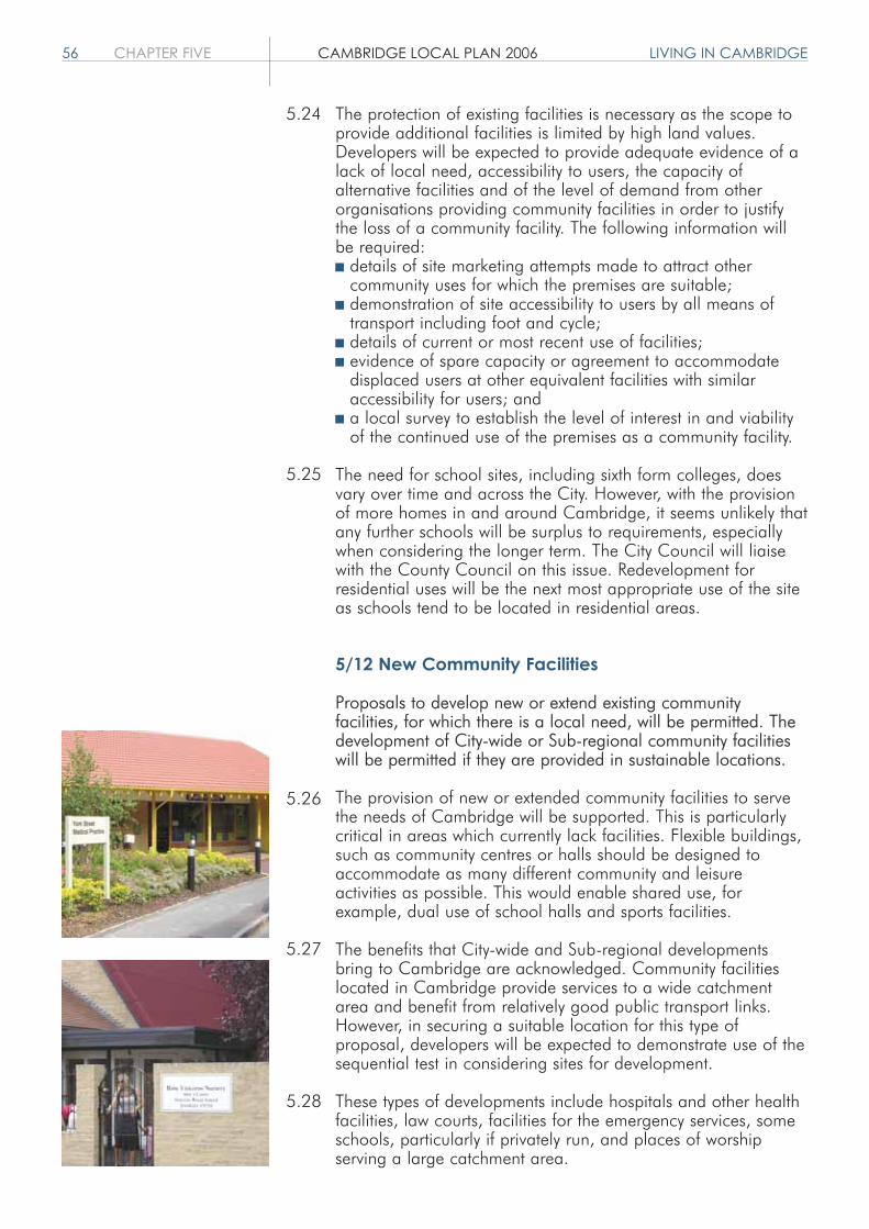
56 CHAPTER FIVE CAMBRIDGE LOCAL PLAN 2006 LIVING IN CAMBRIDGE
The protection of existing facilities is necessary as the scope toprovide additional facilities is limited by high land values.Developers will be expected to provide adequate evidence of alack of local need, accessibility to users, the capacity ofalternative facilities and of the level of demand from otherorganisations providing community facilities in order to justifythe loss of a community facility. The following information willbe required: details of site marketing attempts made to attract other
community uses for which the premises are suitable; demonstration of site accessibility to users by all means of
transport including foot and cycle; details of current or most recent use of facilities; evidence of spare capacity or agreement to accommodate
displaced users at other equivalent facilities with similar accessibility for users; and a local survey to establish the level of interest in and viability
of the continued use of the premises as a community facility.
The need for school sites, including sixth form colleges, doesvary over time and across the City. However, with the provisionof more homes in and around Cambridge, it seems unlikely thatany further schools will be surplus to requirements, especiallywhen considering the longer term. The City Council will liaisewith the County Council on this issue. Redevelopment forresidential uses will be the next most appropriate use of the siteas schools tend to be located in residential areas.
5/12 New Community Facilities
Proposals to develop new or extend existing communityfacilities, for which there is a local need, will be permitted. Thedevelopment of City-wide or Sub-regional community facilitieswill be permitted if they are provided in sustainable locations.
The provision of new or extended community facilities to servethe needs of Cambridge will be supported. This is particularlycritical in areas which currently lack facilities. Flexible buildings,such as community centres or halls should be designed toaccommodate as many different community and leisureactivities as possible. This would enable shared use, forexample, dual use of school halls and sports facilities.
The benefits that City-wide and Sub-regional developmentsbring to Cambridge are acknowledged. Community facilitieslocated in Cambridge provide services to a wide catchmentarea and benefit from relatively good public transport links.However, in securing a suitable location for this type ofproposal, developers will be expected to demonstrate use of thesequential test in considering sites for development.
These types of developments include hospitals and other healthfacilities, law courts, facilities for the emergency services, someschools, particularly if privately run, and places of worshipserving a large catchment area.
5.24
5.25
5.26
5.27
5.28

LIVING IN CAMBRIDGE CAMBRIDGE LOCAL PLAN 2006 CHAPTER FIVE 57
5/13 Community Facilities in the Areasof Major Change
Development in the areas of major change will only bepermitted if they are provided with all appropriate communityfacilities in accordance with an agreed phasing plan. Land maybe allocated for City-wide/Sub-regional community facilities inthese areas. This will be set out in the relevant further guidancefor each scheme.
The areas of major change are of such a scale that existingcommunity facilities in Cambridge will be insufficient to providefor the needs generated by the development. Where it can beshown that City-wide/Sub-regional needs cannot be satisfied inthe existing urban area, land will be allocated for it in the areasof major change.
The location, type and scale of facilities required will partlydepend on the scale of development proposed, its location andevidence of need. However, they may include schools, nurseries,places of worship or religious instruction, premises and sites forthe emergency and health services, libraries, and other facilitiesfor general community use such as community centres andsports halls. Policies 9/3-9/9 contain some further details ofrequirements for particular areas.
5/14 Provision of Community Facilities ThroughNew Development
New developments which lead to an increased demand forcommunity facilities will be expected to provide or contribute tothe provision of appropriate community facilities includingeducation and childcare facilities to meet the needs of residents,employees and visitors.
It is important that when new developments generate the needfor community facilities they are met by contributions from thedeveloper. The City Council has a strategy setting out the typesof obligations that developers will be expected to agree to insecuring planning permission. Other material considerations willalso be taken into account in determining the provision orcontributions for particular sites. If the providers of essentialpublic infrastructure can demonstrate that they are able to meetthe demand for related community facilities generated from newdevelopment, this will satisfy the requirement of Policy 5/14.
Childcare facilities include nurseries, integrated nursery centres,playgroups, crèches and child minding networks whether publicor private.
The provision of such facilities is important to increaseeconomic activity rates, to minimise travel distances, to improvethe quality of life of parents and children and to reduce socialexclusion.
5.29
5.30
5.31
5.32
5.33

58 CHAPTER FIVE CAMBRIDGE LOCAL PLAN 2006 LIVING IN CAMBRIDGE
5/15 Addenbrooke's
Development at Addenbrooke's will be permitted if it can bedemonstrated that it is required to meet local, regional ornational health care needs or for associated biomedical andbiotechnology research and development activities within ClassB1(b), related support activities, related higher education andsui generis medical research institutions. This is provided that itis in accordance with an agreed site Masterplan which coversthe existing hospital campus and any proposed additional areasadjoining.
Addenbrooke's Hospital is a centre of medical excellence andas such has a regional and national role to play in providingmedical facilities as well as a local one. The NHS Trust's 2020Vision outlines plans to develop the site as a biomedical andhealth cluster providing a range of healthcare, biomedical andbiotechnology research and development activities within ClassB1(b), related support activities, related higher education andsui generis medical research institutions. Such development willbe subject to Local Plan policies for the Southern Fringe and theArea Development Framework and its Masterplan.
5.34

ENJOYING CAMBRIDGE CAMBRIDGE LOCAL PLAN 2006 CHAPTER SIX 59
ENJOYING CAMBRIDGEObjectives
1. To ensure that Cambridge is vibrant and thriving with a range of leisure, tourism and shopping facilities in accessible locations to meet the needs of the residents of the City and Sub-region.
Introduction
Policies in this chapter relate to leisure, tourism and shopping.The intention is to ensure Cambridge is a more enjoyable place tolive, work and visit.
Throughout this chapter the term leisure includes outdoor andindoor sports, recreation, entertainment and arts facilities.
Leisure
6/1 Protection of Leisure Facilities
Development leading to the loss of leisure facilities will bepermitted if:a. the facility can be replaced to at least its existing scale and
quality within the new development; orb. the facility is to be relocated to another appropriate premises
or site of similar or improved accessibility for its users.
A wide range of facilities are required to serve the expandingpopulation of Cambridge, its Sub-region, and visitors. This policyseeks to protect uses which support the cultural and entertainmentfunctions of the City as well as outdoor and indoor leisurefacilities. Playing fields are protected under Policy 4/2 and are notcovered by this policy. In redevelopment proposals opportunitiesshould be taken to improve the range of facilities, with all thesignificant user needs and demands met at least as well as before.
In the exceptional circumstances where there is no longer a needfor the leisure facility and the site or building would not be suitablefor an alternative leisure use, development for anon-leisure use may be acceptable.
6/2 New Leisure Facilities
Development for the provision or improvement of a leisure facilitywill be permitted if:a. it improves the range, quality and accessibility of facilities;b. it is of an appropriate scale for the locality; andc. it would not have a negative impact upon the vitality and
viability of the City Centre, including the evening economy.
6.1
6.2
6.3
6.4
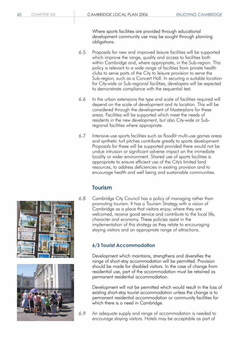
60 CHAPTER SIX CAMBRIDGE LOCAL PLAN 2006 ENJOYING CAMBRIDGE
Where sports facilities are provided through educationaldevelopment community use may be sought through planningobligations.
Proposals for new and improved leisure facilities will be supportedwhich improve the range, quality and access to facilities bothwithin Cambridge and, where appropriate, in the Sub-region. Thispolicy is relevant to a wide range of facilities from private healthclubs to serve parts of the City to leisure provision to serve theSub-region, such as a Concert Hall. In securing a suitable locationfor City-wide or Sub-regional facilities, developers will be expectedto demonstrate compliance with the sequential test.
In the urban extensions the type and scale of facilities required willdepend on the scale of development and its location. This will beconsidered through the development of Masterplans for theseareas. Facilities will be supported which meet the needs ofresidents in the new development, but also City-wide or Sub-regional facilities where appropriate.
Intensive-use sports facilities such as floodlit multi-use games areasand synthetic turf pitches contribute greatly to sports development.Proposals for these will be supported provided there would not beundue intrusion or significant adverse impact on the immediatelocality or wider environment. Shared use of sports facilities isappropriate to ensure efficient use of the City's limited landresources, to address deficiencies in existing provision and toencourage health and well being and sustainable communities.
Tourism
Cambridge City Council has a policy of managing rather thanpromoting tourism. It has a Tourism Strategy with a vision ofCambridge as a place that visitors enjoy; where they arewelcomed, receive good service and contribute to the local life,character and economy. These policies assist in theimplementation of this strategy as they relate to encouragingstaying visitors and an appropriate range of attractions.
6/3 Tourist Accommodation
Development which maintains, strengthens and diversifies therange of short-stay accommodation will be permitted. Provisionshould be made for disabled visitors. In the case of change fromresidential use, part of the accommodation must be retained aspermanent residential accommodation.
Development will not be permitted which would result in the loss ofexisting short-stay tourist accommodation unless the change is topermanent residential accommodation or community facilities forwhich there is a need in Cambridge.
An adequate supply and range of accommodation is needed toencourage staying visitors. Hotels may be acceptable as part of
6.5
6.6
6.7
6.8
6.9

ENJOYING CAMBRIDGE CAMBRIDGE LOCAL PLAN 2006 CHAPTER SIX 61
mixed use development sites and in the urban extensions. Theneeds of disabled people should be considered in all applicationsfor new tourist accommodation, or for alterations to existing.Accommodation with over six guest bedrooms should have at leastone accessible room. Hotels or guest houses with over tenbedrooms should have between 6% and 10% of accessible rooms.These rooms should meet the Visit Britain Stars standards whichthe Tourist Office promotes.
The appropriate balance has to be achieved between protectingresidential properties and meeting the needs of visitors. Forproposals involving the loss of residential, the retention of privateresidential accommodation to be occupied by the proprietor willbe secured by planning condition to ensure there is no loss ofresidential units.
Planning permission will not normally be required for the use oftwo rooms only of a dwelling house as guest bedrooms, the rest ofthe house remaining in family occupation.
6/4 Visitor Attractions
Development which maintains, strengthens and diversifies therange of visitor attractions will be permitted if they are well relatedto the cultural heritage of the city.
A range of attractions and facilities is important to improve thequality of the visitor experience. It may be appropriate for a visitorcentre or exhibition centre to be developed, focusing onCambridge as a centre for High Technology as well as a historicuniversity city. The main purpose of any tourist development shouldbe to assist in the interpretation of the City, not to attractsignificantly more visitors to Cambridge.
The needs of visitors should be considered in all developments inthe City Centre to which the public have access, specifically theneed for more meeting places and covered seating areas.
Shopping
Cambridge is a Sub-regional shopping centre. The shoppinghierarchy starts with the City Centre, which is divided between thehistoric centre, and the Fitzroy-Burleigh area, which includes theGrafton Centre. The daily market on Market Hill is also anessential contributor to the range and choice of shopping in theCity Centre. This is followed by the District and Local Centres. Allof these centres are identified on the Proposals Map.
A study was undertaken in 2001 by Hillier Parker, on behalf of theCounty Council and the City Council, to inform the preparation ofthe Structure Plan and the Local Plan. This looked at the need foradditional retail development in the City. It concluded that therewas no further need for major retail development for eitherconvenience or comparison shopping until 2016, beyond schemes
6.11
6.10
6.12
6.13
6.14
6.15

62 CHAPTER SIX CAMBRIDGE LOCAL PLAN 2006 ENJOYING CAMBRIDGE
already permitted. Therefore no sites have been allocated solelyfor retail development, although there are some mixed useschemes where there will be an element of retail, specifically in theAreas of Major Change.
Shopping policies therefore seek to enhance the vitality andviability of the City Centre and support the role of the District andLocal Centres, rather than promoting major retail expansion. Theyalso recognise that there will be a need for some small-scaleshopping provision in the urban extensions, to meet the localneeds of residents.
Applications for retail developments will, where appropriate, besubject to the demonstration of: need; that a sequential approachhas been adopted; that there will not be an adverse impact onexisting centres; and that transport and environmental mattershave been considered.
6/5 Shopping Development in the City Centre1
Within the City Centre planning permission will only be granted forretail proposals which seek to maintain and enhance the vitalityand viability of the City Centre, and which are of an appropriatenature and scale. The cumulative impact of new retaildevelopment will be considered.
1 The boundary of the City Centre is defined on the Proposals Map.
The Hillier Parker Study concluded that there is no furtherrequirement for major additional shopping floorspace beyond theGrand Arcade scheme and Grafton Centre extension Phase 3which have been permitted. This is supported by the Structure Plan(Policy P9/10) which states that there is no need for major Sub-regional shopping provision in the Cambridge Sub-region to2016, other than approximately 30,000 square metres ofshopping development within the central area of Cambridge City.
Some of the capacity identified by the Structure Plan is committed,but this leaves scope for further small scale additions of retailfloorspace, within the total allowed for in the Structure Plan.However, this does not preclude redevelopment or reorganisationof existing shops to improve the overall attractiveness of the centreor to cater for changing demand or requirements of shoppers, forexample the redevelopment of Bradwell's Court.
6/6 Change of Use in the City Centre1
Change of use from A1 to A2, A3, A4 or A5 uses at ground floorlevel will only be permitted:a. in primary shopping frontages where the proposal would not
harm the contribution the frontage makes to the vitality and viability of the City Centre; and
b. in secondary shopping frontages where the percentage of A1 uses does not fall below 60% (measured by number of units),
6.16
6.17
6.18
6.19

ENJOYING CAMBRIDGE CAMBRIDGE LOCAL PLAN 2006 CHAPTER SIX 63
except for Regent Street/St Andrew's Street (south of Downing Street) where the percentage of A1 uses should not fall below 25%, and Bridge Street (north of Round Church Street) where the percentage of A1 uses should not fall below 40%.
1 The boundary of the City Centre is defined on the Proposals Map.
Primary shopping frontages are defined on the Proposals Map.These frontages contain a high proportion of shopping useswithin Use Class A1, and the policy seeks to maintain this.
Secondary shopping frontages are any thoroughfare within theCity Centre as defined on the Proposals Map, which containClass A uses but are not defined as primary frontages. Here thereis scope for more flexibility of use and diversification has much tooffer. Mixed uses can help to sustain the vitality of centres andcan help to ensure that the centre remains active in the evenings.Therefore, the policies for change of use in these areas are lessrestrictive. Nevertheless, there is concern that new concentrationsof uses, such as restaurants and takeaway food outlets, can havea negative impact and so some degree of control on the mix ofuses is maintained. Such proposals for change of use willtherefore be assessed not only on their positive contribution todiversification, but also on the cumulative effects on such mattersas loss of retail outlets, traffic, parking and residential amenity.
For the purposes of this policy the main secondary frontages are: Bene't Street, Peas Hill, Wheeler Street; Bridge Street (north of Round Church Street); Cobbles Yard, Tredgold Lane; Hobson Street, King Street; Magdalene Street; Regent Street, St Andrew's Street (south of Downing Street); and Trumpington Street.
Changes of use within small frontages (below 10 units) will beassessed on their merits, as described above.
Regent Street/St Andrew's Street and Bridge Street have beenidentified for special treatment because the proportion of A1 usesis significantly below other secondary frontages. Regent Street/StAndrew's Street has a high proportion of estate agents,employment agents and restaurants/cafes/pubs. Bridge Streetalso has a high proportion of restaurants/cafes/pubs. Theconcentration of uses provides a distinctive character, but the CityCouncil would also like to maintain a shopping presence withinthese frontages.
6/7 Shopping Development and Change of Use inDistrict and Local Centres1
Additional development within classes A1, A2, A3, A4 and A5will be permitted in District and Local Centres if it will serve thelocal community and is of an appropriate nature and scale to thecentre.
6.20
6.21
6.22
6.23

64 CHAPTER SIX CAMBRIDGE LOCAL PLAN 2006 ENJOYING CAMBRIDGE
Change of use from A1 to A2, A3, A4 or A5 in District andLocal Centres will only be permitted provided the percentage ofA1 uses does not fall below 60% (measured by number ofunits). Change of use from A1 to other uses will not bepermitted.
1 The boundaries of District and Local Centres are defined on the ProposalsMap.
District and Local Centres serve an important function,providing the ability to shop close to where people live andwork. They help to meet day-to-day needs, thus reducing theneed to travel and dependence on the private car. Additionaldevelopment in these centres should cater mostly for currentusers and other local people, increasing the viability of the localcentre. It should not be of a scale to significantly increase trafficor have any detrimental impact on the vitality and viability ofthe City Centre.
Although permission may be granted for the change of use ofA1 shops to other Class A uses, provided that the level of shopsdoes not fall below 60% or this would result in unacceptableenvironmental problems or nuisance in line with Policy 6/10,the change of use to other uses such as residential or othercommercial uses such as offices will not be permitted unlessthere are exceptional circumstances.
6/8 Convenience Shopping
Convenience shopping will only be permitted if:a. it is for smaller shops (up to 1,400 square metres net) in
existing centres;b. it is a minor extension1 to an existing shop;c. it would replace existing provision in the locality; ord. it is part of mixed use areas including the Station Area and in
the new urban extensions.
1 A minor extension is up to a 10% increase in the net floorspace
There is no further need for major convenience goods netfloorspace in Cambridge until 2016. In existing centres, smallershops are allowed as set out in Policy 6/8. Larger shops wouldbe likely to cause environmental and traffic problems, bearingin mind the character of the City Centre and other centres.There may be scope for small-scale additions such as newconvenience shops in existing centres or urban extensions orminor extensions to existing shops. The City Council wouldsupport the relocation of existing provision to a more accessiblelocation where appropriate, preferably within a centre. Theneed for provision in major urban extensions will be assessed aspart of the preparation of the Masterplans.
6.24
6.25
6.26

ENJOYING CAMBRIDGE CAMBRIDGE LOCAL PLAN 2006 CHAPTER SIX 65
6.27
6.28
6.29
6/9 Retail Warehouses
Retail warehouse development will only be permitted if it is forthe modernisation or replacement of existing retail warehouseswith less than or the same floorspace as before.
There is an over supply of out-of-centre retail warehousing inCambridge, even taking into account the scale of growthforecast for the City and its Sub-region. Therefore, no new out-of-centre retail warehousing will be permitted. However, the CityCouncil recognises that there may be a requirement formodernisation or replacement of existing units during the Planperiod and this is provided for in this policy. Where permissionis granted for such uses, this will be subject to a conditioncontrolling the types of goods that can be sold from thepremises in order to secure the vitality and viability of the Cityand other existing centres.
6/10 Food and Drink Outlets
Developments for Use Classes A3, A4 and A5 (food and drink)will only be permitted:a. where the proposal will not give rise to unacceptable
environmental problems or nuisance and the individual and cumulative impact of the development is considered acceptable; and
b. where it is in an existing centre or is part of a mixed use areain an urban extension or the Station Area.
Food and drink uses (Use Classes A3, A4 and A5) make animportant contribution to the vitality and viability of centres,providing a valuable retail and leisure function. However, theycan have a significant impact in terms of environmentalproblems, traffic problems and loss of residential amenity. Theseproblems are exacerbated where there is a concentration ofsuch uses. Whilst the concentration of such uses is, in part,controlled through Policies 6/6 and 6/7, this policy seeks tocontrol such development on the basis of environmentalimpacts, including the cumulative impact, of suchdevelopments. In addition, this policy seeks to restrict suchdevelopment to existing centres, including the City Centre andDistrict and Local Centres, and mixed use areas in the urbanextensions or the Station Area, rather than in predominantlyresidential areas.
Conditions will be imposed to overcome problems, such ascontrol of the hours of operation and waste disposal and, insome circumstances, may exclude a takeaway service.


WORKING & STUDYING IN CAMBRIDGE CAMBRIDGE LOCAL PLAN 2006 CHAPTER SEVEN 67
Objectives
1. To promote economic growth in sustainable and accessible locations.
2. To promote the growth of and linkages between employment clusters such as high technology/biotechnology/ICT/higher education.
3. To recognise innovation and enable Cambridge's role as a world leader in higher education, research, and knowledge-based industries.
4. To implement the selective management of the economy.
5. To protect the best industrial and storage areas and provide a range of new employment land.
6. To maintain and enhance the diversity of jobs available in the City.
Introduction
Cambridge is fortunate in having a very strong and dynamic localeconomy. The University of Cambridge and the Colleges havehelped develop Cambridge as a centre of excellence and worldleader in the field of education and research. Their success hascontributed to the dynamism, prosperity and further expansion ofthe local economy. The concentration of high technology firmsand links between the Universities, Addenbrooke's Hospital, andother leading edge research facilities have helped with knowledgetransfer from academic research into commercial application. TheLocal Plan makes provision for continued growth of these sectors.
The employment policies in this chapter include policies aimed atthe selective management of the local economy in order toimplement Structure Plan Policy P9/7. The general provisions ofthe Town and Country Planning (Use Classes) Order 1987 andthe Town and Country Planning (General Permitted Development)Order 1995 make this difficult. This chapter therefore includespolicies which can only be implemented if the permitteddevelopment rights for B8 and B2 uses to change to B1 use areremoved. Other policy measures override certain freedoms forchange of use within the B1 Use Class to B1 (a) offices. Theseare implemented by way of conditions and planning obligations.
The policies in this chapter provide for continued growth ofCambridge's successful employment clusters in anenvironmentally sustainable way.
7.1
7.2
7.3
WORKING ANDSTUDYING IN CAMBRIDGE
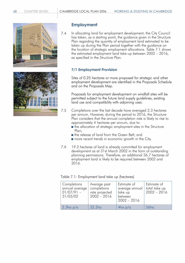
68 CHAPTER SEVEN CAMBRIDGE LOCAL PLAN 2006 WORKING & STUDYING IN CAMBRIDGE
Employment
In allocating land for employment development, the City Councilhas taken, as a starting point, the guidance given in the StructurePlan regarding the quantity of employment land estimated to betaken up during the Plan period together with the guidance onthe location of strategic employment allocations. Table 7.1 showsthe estimated employment land take-up between 2002 – 2016,as specified in the Structure Plan.
7/1 Employment Provision
Sites of 0.25 hectares or more proposed for strategic and otheremployment development are identified in the Proposals Scheduleand on the Proposals Map.
Proposals for employment development on windfall sites will bepermitted subject to the future land supply guidelines, existingland use and compatibility with adjoining uses.
Completions over the last decade have averaged 2.3 hectaresper annum. However, during the period to 2016, the StructurePlan considers that the annual completion rate is likely to rise toapproximately 4 hectares per annum, due to: the allocation of strategic employment sites in the Structure
Plan; the release of land from the Green Belt; and more recent trends in economic growth in the City.
19.3 hectares of land is already committed for employmentdevelopment as at 31st March 2002 in the form of outstandingplanning permissions. Therefore, an additional 36.7 hectares ofemployment land is likely to be required between 2002 and2016.
7.4
7.5
7.6
Completionsannual average01/07/91 – 31/03/02
Average pastcompletionsrate projected2002 – 2016
Estimate ofaverage annualtake upbetween2002 – 2016
Estimate oftotal take up2002 – 2016
2.3ha p/a 32.2ha 4ha p/a 56ha
Table 7.1: Employment land take up (hectares)

WORKING & STUDYING IN CAMBRIDGE CAMBRIDGE LOCAL PLAN 2006 CHAPTER SEVEN 69
Commitmentsand Allocations
OutstandingPermissions2
Former LocalPlan Allocations
StrategicEmploymentSites
Other PriorityAllocations
Otheridentified sites
Windfall sites
New Street/Newmarket Rd2.01 x 50%3
Coldham's Road
East Cambridge4
Addenbrooke's
North West (whenneed proven)
Northern Fringe
Station Area
Mitcham'sCorner0.71 x 40%3
Betjeman House1.17 x 50%3
1.01
0.35
10.00
14.40
6.00
2.00
5
0.28
0.59
17.37
34.63
52.00
4.00
56.00
1.36
30.40
2.00
0.87
Sites (hectares) Sub Total(hectares)
Site Area(hectares)
Total(hectares)
Table 7.2: Future employment land supply, 2002-20161
Commitments
Allocations
Sub Total
Residual
Structure PlanEmploymentGuideline2002 – 2016
1 Base date taken as 31.3.02 for consistency with Structure Plan Employment Guideline.2 Outstanding planning permissions at 31.3.02 discounted by 10% to allow for the non-implementation of planning
permissions (19.3 hectares x 90%).3 Mixed use allocation: site area multiplied by the estimated proportion of the site likely to be brought forward for
employment uses.4 20-25 hectares or 4-5,000 jobs are proposed in the East Area Action Plan Preferred Options for the area as a whole,
of which 10ha comes from the Structure Plan guidelines for the City. This 10ha could be located in the City or South Cambridgeshire and will be determined through masterplanning and the detailed planning application stage.
5 Site area for employment uses not known. Dependent upon detailed design.6 Site 7.03 (Coldham's Lane/Newmarket Road) is a mixed use allocation including B1(a) development. However, this is
restricted to existing floorspace and therefore the allocation is not included in this table.

70 CHAPTER SEVEN CAMBRIDGE LOCAL PLAN 2006 WORKING & STUDYING IN CAMBRIDGE
In determining the location of employment allocations,consideration has been given to the strategic employmentallocations identified in the Structure Plan to the west ofAddenbrooke's Hospital and at Cambridge Airport as well asland at North West Cambridge between Madingley Road andHuntingdon Road (although the Structure Plan requires that thelatter allocation should only be brought forward fordevelopment when the University can show a clear need for theland).
Other areas within the current built up area that are priorityareas for redevelopment (including Cambridge Northern FringeEast and land around the Station) as well as outstandingallocations from the 1996 Cambridge Local Plan have alsobeen considered. In addition, a number of other small siteshave been allocated for employment development in the LocalPlan. Table 7.2 shows how the employment land requirementsare likely to be met during the Plan period through existingplanning permissions as well as allocations in the Local Plan.
The Proposals Schedule allocates 34.63 hectares of land foremployment. The residual employment land take-up (4.00hectares) is anticipated to be brought forward from sites acrossthe City including redevelopment of existing employment sites. Itis anticipated that there will also be loss of existing employmentland to other uses such as housing during the plan period. Thisloss will be monitored and, depending on the scale of the loss,there may be more scope for additional employmentdevelopment elsewhere in the City. This situation will be keptunder review.
These land supply guidelines will guide the determination ofplanning applications. If the monitoring establishes that theaverage annual take-up rate exceeds the estimate of 4 hectaresper annum, or the overall figure of 56 hectares is exceededbefore the end of the Plan period, then the City Council mayrefuse further applications for employment development untilsuch time as the Plan is reviewed.
7/2 Selective Management of the Economy
Employment development proposals, including changes of use,will only be permitted if it can be demonstrated that they fallinto one or more of the following categories:a. the provision of office or other development within Use Class
B1(a) providing an essential service1 for Cambridge as a local or Sub-regional centre or exceptionally where there is aproven need for a regional function; or
b. high technology and related industries and services within Use Class B1(b) concerned primarily with commercial research and development2, which can show a special need to be located close to the Universities or other established research facilities or associated services in the Cambridge Area3; or
7.7
7.8
7.9
7.10

WORKING & STUDYING IN CAMBRIDGE CAMBRIDGE LOCAL PLAN 2006 CHAPTER SEVEN 71
c. other industries within Use Classes B1(c), B2 and B8 on a limited scale4 which would contribute to a greater range of local employment opportunities, especially where this takes advantage of, or contributes to the development of, particular locally based skills and expertise; or
d. D1 educational uses and associated sui generis research establishments and academic research institutes5 that would accord with the provisions of Policy 7/4 where it is in the national interest or there is clear supporting evidence of the need for a Cambridge location.
This policy does not apply to development by establishedbodies6 for their own occupation and use.
1 Essential service is defined as a local or Sub-regional service oradministrative facility for Cambridge or part of the Sub-region. This mightinclude banking, finance, insurance, management and business services,property services, legal and accounting services, education, housing andrecruitment services, medical, other professional and scientific services,patent agents, and specialist component assembly. It might also includesocial firms7 that provide employment and support to members of thecommunity at a disadvantage in the labour market.2 High Technology and Research and Development (see Glossary).3 The Cambridge Area is taken for the purposes of this policy to mean theCambridge City and South Cambridgeshire District Councils' administrativeareas.4 Limited scale will be taken to mean 1,850 square metres or below.5 Research Institutes are taken to mean sui generis uses affiliated with theUniversities, the Medical Research Council or Addenbrooke's Hospital, wherethere is a need for regular day-to-day contact or sharing of materials, staffand equipment. (See Glossary)6 Established is taken to mean five years or more in Cambridge in its currentlawful use.7 A social firm is a business with social and community objectives, createdfor the employment and support of people at a disadvantage in the labourmarket. Profits are re-invested into achieving the firm's social objectives.
Development pressures in and around Cambridge are intenseand yet the availability of land is limited. There is a need tobalance the growth of the economy with the protection of theenvironment. To this end, over many years the local authoritiesin the area have operated a policy of the selective managementof the economy. Both Regional Planning Guidance (RPG6,Policy 26) and the Cambridgeshire and Peterborough StructurePlan (Policy P9/7) recognise the continuing role of this planningpolicy, discriminating in favour of uses that have an essentialneed for a Cambridge location, such as for higher education,related to the development needs of the research andtechnology based clusters, or providing services to the localpopulation. This policy is therefore intended to guide the type ofemployment development in the City.
Employment land in and close to Cambridge will be reservedfor development that can demonstrate a clear need to belocated in the area in order to serve local requirements orcontribute to the continuing success of the Sub-region as acentre for high technology and research.
7.11
7.12

72 CHAPTER SEVEN CAMBRIDGE LOCAL PLAN 2006 WORKING & STUDYING IN CAMBRIDGE
This will include commercial high technology research anddevelopment uses, further and higher educational uses within UseClass D1, and associated sui generis research institutes. Theseneed close links with University departments and other researchorganisations in the area. Development under this policy will beregulated by way of a condition, or a planning obligation, torestrict the future occupation and use of the premises for thepurposes proposed.
The policy seeks to restrict office development to businesses ororganisations that provide a local or Sub-regional function.Exceptionally office style employment serving a regional functionmay be located within the City, in recognition of the growing roleof Cambridge as a centre for the East of England Region. Thiswould, for example, include regional government and othergovernment agencies and public bodies. However, applicants forregional office development will need to demonstrate a provenneed for a regional function and a Cambridge location. Eachcase would be considered on its merits. It would not however bedesirable for general office development, such as nationalheadquarter offices, call centres or similar, to develop inCambridge exacerbating labour shortages and long distancecommuting.
Large-scale mass production and regional warehousing andstorage within Use Classes B1(c), B2 or B8 are not appropriateuses within Cambridge because of their likely large land take andlabour force demands adding pressure for housing. However,small-scale developments of 1,850 square metres or below mayserve to widen the range of jobs available locally, especiallywhere there is a predominance of high technology jobs, and soserve to redress the current imbalance and diversify the economy.
The occupation of developments will be controlled by legalagreement.
Whilst the selective management of the economy is an importantaspect of planning policy within the City, it is recognised thatthere are some long established firms within the City who, whilstnot meeting the other criteria of this policy, nevertheless make avery important contribution to the economy of the City and itsSub-region. The growth and expansion of such firms is supportedprovided development is for their own use, and the scale iscompatible with other aims of the Plan. Firms are encouraged tolook beyond the Cambridge Sub-region or in the market towns orat the strategic employment location at Alconbury Airfield forlarger scale expansion.
The Plan also recognises the role of social firms, whosecommunity benefit can only be accrued if they are based withinthe community, and who provide employment and support todisadvantaged and marginalised residents for whom theseservices would be out of reach if based outside the city.
Guidance will be prepared concerning the assessment ofapplications against this policy.
7.13
7.14
7.15
7.16
7.17
7.18
7.19

WORKING & STUDYING IN CAMBRIDGE CAMBRIDGE LOCAL PLAN 2006 CHAPTER SEVEN 73
7/3 Protection of Industrial and Storage Space
Development, including changes of use, that results in loss offloorspace within Use Classes B1(c), B2 and B8 will not bepermitted where the site is identified on the Proposals Map as aprotected industrial/storage site. Development, including changesof use, that results in a loss of floorspace within Use ClassesB1(c), B2 and B8 elsewhere in the City will only be permitted if:a. there is sufficient supply of such floorspace in the City to
meet the demand and/or vacancy rates are high; and eitherb. the proposed development will generate the same number or
more unskilled or semi-skilled jobs than could be expected from the existing use; or
c. the continuation of industrial and storage uses will be harmful to the environment or amenity of the area; or
d. the loss of a small proportion of industrial or storage floorspace would facilitate the redevelopment and continuation of industrial and storage use on a greater part of the site; or
e. redevelopment for mixed use or residential development would be more appropriate.
There is an ongoing concern that there should be a diversity ofemployment opportunities and a full range of services inCambridge. One of the inherent dangers of the policy for theselective management of the economy is that it could limit therange of job opportunities and services in the area. In an attemptto maintain some balance in the economy, the bestindustrial/storage sites (meaning B1(c), B2 and B8 uses) inCambridge are specifically protected from redevelopment forother uses, whilst other industrial/storage sites across the City canonly be redeveloped for alternative uses if certain criteria are met.In essence, a policy of 'protect the best, evaluate the rest'.
For those industrial/storage sites that are not specifically protectedby this policy, the evaluation of proposals for the loss of suchfloorspace will consider a number of factors. First, considerationwill be given to the current levels of supply, demand and vacancyrates in the City for each use. Where there is sufficient supply tomeet demand, or the vacancy rates for a use are high, then theloss of the use will be acceptable in principle.
If, upon analysis of supply, demand and vacancy rates, it hasbeen determined that the loss of the use would be acceptable inprinciple, consideration will then be given to a number of otherfactors as set out in the policy. Permission will be granted fordevelopment that would generate the same number or moreunskilled or semi-skilled jobs than could be expected from theexisting use. If the continuation of industrial and storage uses willbe harmful to the environment or amenity of the area or the lossof a small proportion of floorspace would facilitate thedevelopment and continuation of industrial and storage use on agreater part of the site, then permission will also be granted.Finally, permission will also be granted if residential developmentis proposed, to help meet the need for housing in Cambridge.
7.20
7.21
7.22

74 CHAPTER SEVEN CAMBRIDGE LOCAL PLAN 2006 WORKING & STUDYING IN CAMBRIDGE
Guidance will be prepared concerning the assessment ofapplications against this policy.
7/4 Promotion of Cluster Development
Development will be permitted which fosters innovation andhelps reinforce the existing high technology and researchclusters of Cambridge, and which can demonstrate a clearneed to be located in the area. This will include:a. healthcare, biomedical and biotechnology development;b. higher education and related research institutes;c. computer software and services;d. telecommunications; ande. other high technology clusters as they emerge.
The provision of purpose-designed accommodation will beencouraged to provide for these sectors. These will include thedevelopment of commercial high technology incubator units,new academic facilities and sui generis research establishmentsthat are in the national interest or where there is clearsupporting evidence of the need for a Cambridge location.
Locations particularly suited to these activities include:a. land west of Addenbrooke's Hospital for healthcare
biomedical and biotechnology research and development activities, related support activities; related higher education and sui generis research institutes;
b. land at west Cambridge for higher education and associatedresearch facilities needing close proximity to the scientific faculties being established there; and
c. land between Madingley Road and Huntingdon Road for higher education and associated research facilities to enable the continued development of the University education and research cluster.
The Cambridge Phenomenon is well documented, havingoriginally been described by Segal Quince and Partners in themid 1980s. The term refers to the large numbers of hightechnology companies in and around Cambridge, many ofwhich are, small, young independent start-ups, focussing uponresearch, design and development activities and the inter-relationships that has built up between these firms, theUniversity and Colleges and other research organisations.
More recently, such agglomerations have been referred to asclusters. There are a number of clusters that have developed inCambridge. These include computer software and services,education, telecommunications and healthcare teaching andresearch.
In addition the National Research Councils have for some timebeen promoting Interdisciplinary Research Centres (IRCs) whichoffer opportunity for academic collaboration with business inkey technologies. Cambridge has already attracted a number ofthese.
7.23
7.24
7.25
7.26
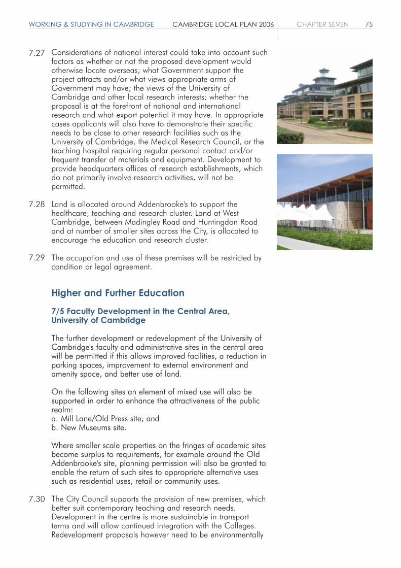
WORKING & STUDYING IN CAMBRIDGE CAMBRIDGE LOCAL PLAN 2006 CHAPTER SEVEN 75
Considerations of national interest could take into account suchfactors as whether or not the proposed development wouldotherwise locate overseas; what Government support theproject attracts and/or what views appropriate arms ofGovernment may have; the views of the University ofCambridge and other local research interests; whether theproposal is at the forefront of national and internationalresearch and what export potential it may have. In appropriatecases applicants will also have to demonstrate their specificneeds to be close to other research facilities such as theUniversity of Cambridge, the Medical Research Council, or theteaching hospital requiring regular personal contact and/orfrequent transfer of materials and equipment. Development toprovide headquarters offices of research establishments, whichdo not primarily involve research activities, will not bepermitted.
Land is allocated around Addenbrooke's to support thehealthcare, teaching and research cluster. Land at WestCambridge, between Madingley Road and Huntingdon Roadand at number of smaller sites across the City, is allocated toencourage the education and research cluster.
The occupation and use of these premises will be restricted bycondition or legal agreement.
Higher and Further Education
7/5 Faculty Development in the Central Area,University of Cambridge
The further development or redevelopment of the University ofCambridge's faculty and administrative sites in the central areawill be permitted if this allows improved facilities, a reduction inparking spaces, improvement to external environment andamenity space, and better use of land.
On the following sites an element of mixed use will also besupported in order to enhance the attractiveness of the publicrealm:a. Mill Lane/Old Press site; andb. New Museums site.
Where smaller scale properties on the fringes of academic sitesbecome surplus to requirements, for example around the OldAddenbrooke's site, planning permission will also be granted toenable the return of such sites to appropriate alternative usessuch as residential uses, retail or community uses.
The City Council supports the provision of new premises, whichbetter suit contemporary teaching and research needs.Development in the centre is more sustainable in transportterms and will allow continued integration with the Colleges.Redevelopment proposals however need to be environmentally
7.27
7.28
7.29
7.30

76 CHAPTER SEVEN CAMBRIDGE LOCAL PLAN 2006 WORKING & STUDYING IN CAMBRIDGE
sensitive and should be compatible with design andconservation objectives. Reducing private non-residentialparking will provide scope for more amenity space andcontribute to reductions in central area traffic congestion. Keycentral sites where change is occurring include the Old Presssite Mill Lane, New Museums, Downing site, the former Schoolof Divinity, Old Addenbrooke's, the Old Schools, FitzwilliamMuseum, Chemistry, Scroope House site and Engineering.Major development outside the centre includes developmentaround Addenbrooke's and its Clinical School associated withthe Trust's 2020 Vision, a new Cancer Research Centre atAddenbrooke's, a relocation of the Department of Education tothe Homerton College site, continuing improvements to theSidgwick Arts Faculty site, and major new Universitydevelopment in West Cambridge and North West Cambridge.
7/6 West Cambridge, South of Madingley Road
Development for University needs will be permitted on thefollowing site south of Madingley Road:
Site 7.06 West Cambridge SiteThis site is a major allocation in the 1996 Local Plan forUniversity Faculty development, Research Institutes, commercialresearch and development, a sports complex, residential andassociated uses. Development of the site has commenced inaccordance with an agreed Masterplan. The site will providedevelopment opportunity for the Plan period and beyond.Further development, which accords with the provisions of theMasterplan, will be permitted. Progress against the Masterplanwill be monitored and reviewed over the Plan period.
To the south of Madingley Road a major new academicdevelopment is being undertaken by the University ofCambridge to provide a range of new space for academic andother uses. It is one of the largest developments everundertaken in the City and will contribute towards the Universitymaintaining its position as one of the world's foremostuniversities. The overall site, which covers 66.5 hectares, wasthe subject of an outline planning approval in 1999, and aMasterplan has been agreed with the University for thedevelopment of approximately 250,000 square metres ofspace. Reserved matters applications have been approved on anumber of plots at the eastern end of the site and a number ofsites are under construction or have been recently completed.
Completions include a new computer laboratory (10,500square metres), a prestigious new research building forMicrosoft (6,100 square metres), a new Nano Science building(2,300 square metres) and a park and cycle scheme.
Planning approval has been granted for a new sports complex.A new building for the Centre for Advanced Photonics andElectronics in conjunction with the Department of Engineering isplanned. Applications have been approved or are being
7.31
7.32
7.33

WORKING & STUDYING IN CAMBRIDGE CAMBRIDGE LOCAL PLAN 2006 CHAPTER SEVEN 77
discussed regarding the development of the East Square andEast Forum. 200 residences are nearing completion and a siteis being sought for 200 more. Infrastructure and strategiclandscaping proposals have also been approved andprogressed.
Implementation of other elements of the Masterplan are relianton securing further Joint Infrastructure Funding and otherfunding to help the relocation of Materials Science andEngineering Departments onto the site.
It will be many years before the site is fully developed, perhaps2020, and the precise sequence cannot be accurately predictedbecause of uncertainties over funding and the timing ofdevelopments. The Masterplan therefore creates a strategicframework to guide the future development of the site. Itincludes a series of guidelines for the purposes of monitoringthe progress of development. This will be reviewed during thePlan period as required.
7/7 College and University of Cambridge Staffand Student Housing
Sites suitable for the development of student hostels oraffordable or special needs housing for the Colleges andUniversity staff are identified in the Proposals Schedule and onthe Proposals Map.
The development of additional student residentialaccommodation within existing College sites1 will be permitted.
Planning permission will be granted for windfall and studenthostel sites subject to:a. amenity considerations;b. their proximity to the institutions they serve;c. supervision, if necessary, is provided as appropriate to their
size, location and the nature of the occupants; andd. they do not result in a loss of family residential
accommodation.
Appropriate provision should be made for students who aredisabled.
1 Existing College sites are taken to mean sites already accommodating 20or more students or sites that have planning permission for such.
Student numbers at the University of Cambridge have grown by2.0% per annum over the last decade. Within this,undergraduates have increased by 1.1% per annum andpostgraduates 4.6% per annum. The most recent forecasts bythe University adopted for space planning are moreconservative. They suggest undergraduate numbers are likely togrow by around 0.5% per annum to 2011 with postgraduateincreases of around 2.0% per annum.
7.34
7.35
7.36

78 CHAPTER SEVEN CAMBRIDGE LOCAL PLAN 2006 WORKING & STUDYING IN CAMBRIDGE
Large increases are also anticipated in unestablished academicstaff. These include postdoctoral research workers and technicalstaff, many of whom work on short-term contracts. A 90%increase in numbers has been witnessed here since 1991.
Despite the increase in numbers, the Colleges have increasedthe proportion of students that they are able to house in hostelaccommodation since 1991. Some 92% of undergraduates and54% of postgraduates were housed in purpose-built Collegehostels in 2001. The proportion of postgraduates housed,however, has dipped slightly since 1999. A number of Collegesprovide housing for all students. Much of the growth in numbersis likely to be in graduate students, some of whom need familyaccommodation.
Due to relatively low wage levels and high house prices there isa problem of University and College employees not being ableto afford the housing they need; the University will becomedirectly involved in providing affordable key worker housing forstaff.
The needs of disabled people should be considered in allapplications for new student accommodation, or for alterationsto existing. Adequate rooms should be designed or adapted tomeet the needs of disabled students to accord with therequirements of relevant British Standards, the current BuildingRegulations or other relevant legislation.
It is important that the Local Plan makes adequate provision forCollege and University residential needs. The ProposalsSchedule and Proposals Map allocate a number of sites forstudent accommodation. A positive attitude will be takentowards additional windfall student hostel sites that may comeforward. The location of such hostels will need to respect thecharacter and residential amenity of the local area in which theyare sited. Depending on their size, location, distance from theinstitution served, and nature of occupants, appropriatesupervision arrangements may be required. Any sites currently inrecreational use will be assessed against policy 4/2 andparagraph 4.10. Policies concerning affordable, key workerhousing, and houses in multiple occupation are dealt with inthe 'Living in Cambridge' chapter.
7/8 Anglia Ruskin University East Road Campus
The upgrade and limited further development of the University'sEast Road site to provide teaching, administrative, residential,social and amenity facilities will be permitted provided that:a. development accords with an agreed Masterplan; andb. there is a reduction in private parking on site.
In the longer term, whilst East Road will continue to beconsidered as the University's primary campus, its needs forlonger term growth for academic and student accommodationwould be supported, in particular at East Cambridge.
7.37
7.38
7.39
7.40
7.41

WORKING & STUDYING IN CAMBRIDGE CAMBRIDGE LOCAL PLAN 2006 CHAPTER SEVEN 79
7/9 Student Hostels for Anglia Ruskin University
Sites suitable for the development of student hostels for AngliaRuskin University are identified in the Proposals Schedule andon the Proposals Map. These sites and provision aresafeguarded and development for alternative uses will not bepermitted except where existing bodies are seeking to refurbish,rationalise or extend the premises for their own use andoccupation. If these sites are also providing residentialaccommodation no requirement for affordable housing will besought under Policy 5/5 provided a significant proportion ofstudent hostel accommodation is included to meet the needs ofAnglia Ruskin University. Appropriate provision should be madefor students who are disabled.
The City Council is committed to supporting the development ofAnglia Ruskin University, to provide a higher educationestablishment which can meet the needs of the region. This willcontinue to be important to the economy and community of theCity. However, given the pressures on the housing market inCambridge it is not acceptable to expand student numberswithout providing a much higher level of purpose-built studenthostel accommodation. Financial limitations mean this has beendifficult in the past. The City Council will, for its part, continueto look for opportunities to assist with the provision of sites forhostels for Anglia students. If windfall opportunities arise fordevelopment for Anglia Ruskin University within the existingurban area, the City Council will assess them against the LocalPlan on their merits and will not require such provision to bemade at East Cambridge.
Anglia Ruskin University occupies a congested central site, buthas limited potential for development because of the presenceof temporary buildings and a commitment to reduce on-siteparking. A draft Development Framework has recently beenreceived as a context for the improvement and rationalisation ofthe site over the next five to ten years. An outline application forthe whole site is currently pending.
The first phase, which has recently been approved, involves anew administrative building, a student social centre andteaching block to the rear of the Helmore building. Phase 2provides space for further faculty development. Phase 3comprises a new Community Arts Centre linking the Helmoreextension with a consolidation of Arts and Letters to the rear ofthe Ruskin building.
Other improvements involve the rationalisation of car parkingand improvements to the quality of the environment on the site.
The University has been growing quite rapidly over the last tenyears. Numbers of full time higher education students areanticipated to increase from around 10,370 in 2001/2 toabout 11,140 by 2006. They are projected to then increaseonly gradually to around 11,580 by 2009/10.
7.42
7.43
7.44
7.45
7.46

80 CHAPTER SEVEN CAMBRIDGE LOCAL PLAN 2006 WORKING & STUDYING IN CAMBRIDGE
Anglia Ruskin University is critically short of student residentialaccommodation: there are few student hostel places. It isheavily dependent on houses acquired on short leases and onlodging accommodation with local families. Its students create asignificant demand for private rented housing and many have toput up with very poor quality accommodation. Governmentchanges to higher education funding puts students in an evenworse position in getting suitable accommodation in expensivehousing areas like Cambridge. Even if its current developmentprogramme is achieved, Anglia Ruskin University will only havearound 9.8% of its 4,900 full time undergraduate studentshoused in University controlled hostels. This compares with over92% of undergraduate students who are housed by theUniversity of Cambridge's Colleges. Further increases areexpected over the Plan period.
It is the desire of Anglia Ruskin University to house as manyof its students as possible in purpose-built hostelaccommodation. The City Council encourages and supportsthis aim. Where new purpose-built student hostelaccommodation is successfully provided the City Council willencourage the return of as many bedspaces as possible held inprivate leased houses back to open housing market occupation.The University is beginning to do this and has returnedapproximately 650 bedspaces back to the open market since1995. It had around 250 bedspaces in 47 properties remainingon head leases in 2003.
A number of sites are allocated for student residentialaccommodation in the Proposals Schedule and Proposals Map.All of these sites are currently in other uses and it is not certainthey will become available in the Plan period. Given theshortage of suitable sites if they do become available it isimportant that they are safeguarded to help meet this underprovision of student accommodation. On other sites the CityCouncil will consider the criteria mentioned under Policy 5/7 onSupported Housing, in determining such planning applications.
Figure 7.1: Growth in Student Numbers at Anglia Ruskin University.
Source: Anglia Ruskin University, February 2003.
7.47
7.48
7.49

WORKING & STUDYING IN CAMBRIDGE CAMBRIDGE LOCAL PLAN 2006 CHAPTER SEVEN 81
Table 7.3: Anglia Ruskin University Hostel Accommodation.
Location of Accommodation Number of Bed Spaces 1998/9 Number of Bed Spaces 2002/3
Swinhoe House Bradmore St
Bridget's & Nightingalehostels, Tennis Court Road
Peter Taylor House,East Road Campus
Anglia Ruskin University HostelSub Total
Managed head leasedproperties including CAMCAT(reduced from about 900 in1995)
Lodgings
University owned, CollierRoad and adjoining streets(13 properties)
Other Accommodation:
CAMCAT HousingAssociation (4 properties)
Available in YMCA (mainlyone semester overseasstudents)
Sub Total College provided
Contracted with private sector(652 properties in 1998/9)
Total
119
106 (including 8 units atBridget's Hostel, for disabledstudents, some fromUniversity of Cambridge)
254 (available 1999/2000)
479 (= 10.74%full time students)
434 (in 72 Properties)
88
13
25
32
1,071 (= 24.03%of full time students)
1,323
2,394 (= 53.71%of full time students)
119
106 (including 8 units atBridget's Hostel, for disabledstudents, some from Universityof Cambridge)
254
479 (= 9.68%full time students)
251 (in 47 properties)
22
77
25
32
886 (= 17.91%of full time students)
800
1,686 (= 34.09%of full time students)
Source: Anglia Ruskin University February 2003/ CCC Local Plan Monitoring Report 1999.

82 CHAPTER SEVEN CAMBRIDGE LOCAL PLAN 2006 WORKING & STUDYING IN CAMBRIDGE
7/10 Speculative Student Hostel Accommodation
The development of speculative purpose-built student hostelswill only be permitted if:a. occupancy restrictions exist to ensure the accommodation is
only available to full time students attending Anglia Ruskin University or the University of Cambridge;
b. appropriate management arrangements are in place to ensure students do not keep cars in Cambridge;
c. they are reasonably close or accessible to the institutions theyserve; and
d. they make appropriate provision for students who are disabled.
A number of speculative developments have occurred in recentyears to provide purpose-built student hostel developments.These have not always provided accommodation on a termbasis for full time students attending Anglia Ruskin University. Inview of the difficult student housing shortages faced by theUniversity, and the limited number of sites and pressures to usethis accommodation for other purposes such as languagestudent accommodation, a planning condition or obligation willbe imposed on future developments to ensure suchaccommodation is used by a named institution (either AngliaRuskin University or the University of Cambridge) during itsteaching terms.
Both Universities operate systems of proctorial control over theirstudents bringing cars to Cambridge. It is important in the caseof speculative developments by other landlords that appropriatemanagement controls are put in place to prevent studentoccupants keeping cars. For reasons of sustainability it isdesirable that sites are close or accessible to the institutions theyserve.
The City Council will consider the criteria mentioned underPolicy 5/7 on Supported Housing in determining planningapplications for hostel accommodation.
The City Council will look favourably upon developmentproposals for student hostels on sites which might not otherwisebe suitable for residential use by reason of amenity, trafficgeneration or location.
7/11 Language Schools
The establishment of additional permanent or temporarylanguage schools will not be permitted. Development at existingschools will be permitted where existing facilities are beingimproved or teaching floorspace is being increased by no morethan 10% of existing floorspace.
Permissions given for the expansion of non-teaching space willbe subject to planning conditions or legal agreements toprevent the use of such space for teaching. Extension tolerances
7.50
7.51
7.52
7.53
7.54

WORKING & STUDYING IN CAMBRIDGE CAMBRIDGE LOCAL PLAN 2006 CHAPTER SEVEN 83
are based on the original building floorspace and are a onetime only concession. Development to provide purpose-builtstudent hostel accommodation on existing sites will be permittedprovided this is not intended to facilitate an increase in studentnumbers. The City Council will consider the criteria mentionedunder Policy 5/7 on Supported Housing in determining suchplanning applications.
Control of seasonal language schools through planninglegislation will not be achieved easily: the use of existingeducational establishments falls outside planning control andthe relatively short duration of operation may avoid theenforcement process. However, a programme of identifyingpremises which cause problems followed by the service of anenforcement notice prohibiting use for language teaching maybe effective and will be used where appropriate. Otherlegislative controls may also be used.
7.55


CONNECTING & SERVICING CAMBRIDGE CAMBRIDGE LOCAL PLAN 2006 CHAPTER EIGHT 85
CONNECTING ANDSERVICING CAMBRIDGE
Objectives
1. To minimise the distances people need to travel, particularly by car.
2. To maximise accessibility for everyone, particularly to jobs and essential services.
3. To minimise adverse effects of transport on people and the environment.
4. To ensure adequate provision of sustainable forms of infrastructure to support the demands of the City.
5. To promote a safe and healthy environment, minimising the impacts of development upon the environment.
Introduction
This chapter contains policies relating to networks, includingtransport and telecommunications, as well as policiesconcerned with infrastructure requirements of developmentincluding energy generation and waste.
Transport
Cambridge is an accessible City, where walking and cycling areattractive and popular. Whilst car use is lower than in manycities, there is a considerable amount of car commuting intoCambridge and only limited road space. The problems causedby the resulting congestion are well known; pollution, increasedjourney times and hence costs to business, and deterioratingconditions for public transport, pedestrians and cyclists.Moreover, demand for transport is continually rising due tolifestyle changes and urban expansion.
The City Council will continue to work closely withCambridgeshire County Council, and other partners, in order toimprove public transport, cycling and walking networks and tomanage the demand for car travel. Applying one type ofmeasure without the other would be likely to be ineffective. Asthe Planning Authority, the City Council can influence transportconditions and it has the ability to greatly contribute to theabove objectives through the control of development. Theintroduction of tighter car parking standards will encourage amodal shift away from car use. The City Council will encourageCambridgeshire County Council as the Highway Authority tointroduce further measures through the Local Transport Plan
8.1
8.2
8.3

86 CHAPTER EIGHT CAMBRIDGE LOCAL PLAN 2006 CONNECTING & SERVICING CAMBRIDGE
such as the expansion of the Controlled Parking Zone and tocarefully assess the feasibility of fiscal measures such as road usercharging or a workplace parking levy.
References in this document to the Cambridgeshire Guided Busrelate to the scheme proposed by Cambridgeshire County Councilfor a rapid transit scheme using guided bus technology in theHuntingdon to Trumpington corridor. The scheme was granted aTransport and Works Act Order in December 2005. Subsequentlydeemed planning permission was issued for the necessary workssubject to 10 conditions.
8/1 Spatial Location of Development
For non-residential proposals likely to attract a large number oftrips, applicants should demonstrate that the location is the mostsuitable with regard to access by public transport, cycling andwalking. In general, the sequential approach should be followed,whereby preference is given to more central locations.
It is important that the location of new development shouldminimise the need for private car use, and maximise the scope foraccess by sustainable modes of transport. For this reason, acentral location will often be preferable, due to the high availabilityof public transport services from outer areas of Cambridge andthe Sub-region.
Out-of-centre non-residential development will only be acceptablewhere it can be clearly demonstrated that the location is suitable,and will not encourage additional car use compared with a morecentral location. This approach seeks to avoid or reduce trafficimpact where this may affect bus service reliability. Goodaccessibility by public transport will still need to be ensured.
8/2 Transport Impact
Developments will only be permitted where they do not have anunacceptable transport impact. Proposals must include sufficientinformation in order for the likely impact to be assessed.
It is important that development does not have an unacceptableimpact on the transport network, and this should be demonstratedas part of any application. In areas of the City where trafficcongestion is particularly high, the Council may seek a zeroincrease or reduction in car traffic generation through anyproposed redevelopment. It should also be demonstrated that thelevel of parking proposed is consistent with the results of anyTransport Assessment submitted.
8/3 Mitigating Measures
For development likely to place demand on the transport system,suitable mitigating measures will be required. Financial
8.4
8.5
8.6
8.7

CONNECTING & SERVICING CAMBRIDGE CAMBRIDGE LOCAL PLAN 2006 CHAPTER EIGHT 87
contributions will be sought towards improvements in transportinfrastructure in the wider area affected by increased development,in particular to support public transport, cycling and walking.Developments will also be required to provide any necessary site-specific measures, and a staff travel plan will be required for non-residential developments.
As the development of the City increases, so does the need fortransport. The current infrastructure has little spare capacity and isseriously strained in many areas. Therefore, financial contributionswill be sought towards schemes approved by the City and CountyCouncils for the necessary improvements in the Sub-region. Anappropriate methodology for quantifying the level of contributionsin relation to the likely impact of the development will be detailedin a Supplementary Planning Document.
Where redevelopment of a currently occupied site is proposed, theexisting demand on the transport network will be taken intoaccount. If it can be shown that no additional transport demandwill be generated, then contributions will not be required.
Planning Obligations will be used to secure payments formeasures that cannot be secured through a planning condition.Any other legal powers available to the Planning Authority mayalso be used to secure payments.
8/4 Walking and Cycling Accessibility
To support walking and cycling, all development will be designedto:a. give priority for these modes over cars;b. ensure maximum convenience for these modes;c. be accessible to those with impaired mobility; andd. link with the surrounding walking and cycling network.
Walking and cycling are of high priority, being healthy, affordableand sustainable modes of travel. One of the best ways toencourage these modes is to fully include them at the planningstage. Priority and convenience for walking and cycling should beensured through the design layout, traffic calming measures, andon-site facilities, as set out in the Cambridge Walking and CyclingStrategy. The needs of all users should be considered, to ensureaccessibility for pushchairs and wheelchairs. Factors such as safety,personal security and potential conflicts between users should alsobe considered.
8/5 Pedestrian and Cycle Network
New developments will safeguard land along identified routes forthe expansion of the walking and cycling network. In addition,funding for high quality physical provision of these routes will berequired, both within and adjacent to the proposed developmentsite. Any existing routes should be retained and improved whereverpossible.
8.8
8.9
8.10
8.11
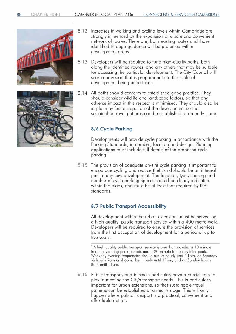
88 CHAPTER EIGHT CAMBRIDGE LOCAL PLAN 2006 CONNECTING & SERVICING CAMBRIDGE
Increases in walking and cycling levels within Cambridge arestrongly influenced by the expansion of a safe and convenientnetwork of routes. Therefore, both existing routes and thoseidentified through guidance will be protected withindevelopment areas.
Developers will be required to fund high-quality paths, bothalong the identified routes, and any others that may be suitablefor accessing the particular development. The City Council willseek a provision that is proportionate to the scale ofdevelopment being undertaken.
All paths should conform to established good practice. Theyshould consider wildlife and landscape factors, so that anyadverse impact in this respect is minimised. They should also bein place by first occupation of the development so thatsustainable travel patterns can be established at an early stage.
8/6 Cycle Parking
Developments will provide cycle parking in accordance with theParking Standards, in number, location and design. Planningapplications must include full details of the proposed cycleparking.
The provision of adequate on-site cycle parking is important toencourage cycling and reduce theft, and should be an integralpart of any new development. The location, type, spacing andnumber of cycle parking spaces should be clearly indicatedwithin the plans, and must be at least that required by thestandards.
8/7 Public Transport Accessibility
All development within the urban extensions must be served bya high quality1 public transport service within a 400 metre walk.Developers will be required to ensure the provision of servicesfrom the first occupation of development for a period of up tofive years.
1 A high quality public transport service is one that provides a 10 minutefrequency during peak periods and a 20 minute frequency inter-peak.Weekday evening frequencies should run ½ hourly until 11pm, on Saturday½ hourly 7am until 6pm, then hourly until 11pm, and on Sunday hourly8am until 11pm.
Public transport, and buses in particular, have a crucial role toplay in meeting the City's transport needs. This is particularlyimportant for urban extensions, so that sustainable travelpatterns can be established at an early stage. This will onlyhappen where public transport is a practical, convenient andaffordable option.
8.12
8.13
8.14
8.15
8.16
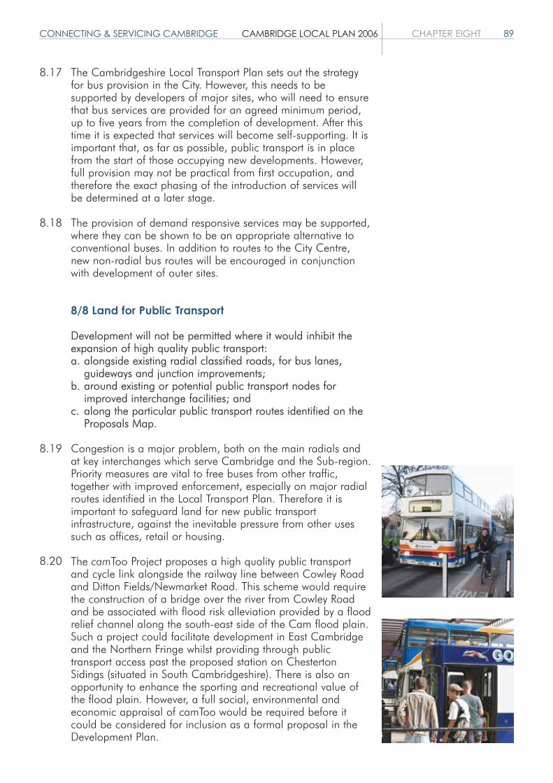
CONNECTING & SERVICING CAMBRIDGE CAMBRIDGE LOCAL PLAN 2006 CHAPTER EIGHT 89
The Cambridgeshire Local Transport Plan sets out the strategyfor bus provision in the City. However, this needs to besupported by developers of major sites, who will need to ensurethat bus services are provided for an agreed minimum period,up to five years from the completion of development. After thistime it is expected that services will become self-supporting. It isimportant that, as far as possible, public transport is in placefrom the start of those occupying new developments. However,full provision may not be practical from first occupation, andtherefore the exact phasing of the introduction of services willbe determined at a later stage.
The provision of demand responsive services may be supported,where they can be shown to be an appropriate alternative toconventional buses. In addition to routes to the City Centre,new non-radial bus routes will be encouraged in conjunctionwith development of outer sites.
8/8 Land for Public Transport
Development will not be permitted where it would inhibit theexpansion of high quality public transport:a. alongside existing radial classified roads, for bus lanes,
guideways and junction improvements;b. around existing or potential public transport nodes for
improved interchange facilities; andc. along the particular public transport routes identified on the
Proposals Map.
Congestion is a major problem, both on the main radials andat key interchanges which serve Cambridge and the Sub-region.Priority measures are vital to free buses from other traffic,together with improved enforcement, especially on major radialroutes identified in the Local Transport Plan. Therefore it isimportant to safeguard land for new public transportinfrastructure, against the inevitable pressure from other usessuch as offices, retail or housing.
The camToo Project proposes a high quality public transportand cycle link alongside the railway line between Cowley Roadand Ditton Fields/Newmarket Road. This scheme would requirethe construction of a bridge over the river from Cowley Roadand be associated with flood risk alleviation provided by a floodrelief channel along the south-east side of the Cam flood plain.Such a project could facilitate development in East Cambridgeand the Northern Fringe whilst providing through publictransport access past the proposed station on ChestertonSidings (situated in South Cambridgeshire). There is also anopportunity to enhance the sporting and recreational value ofthe flood plain. However, a full social, environmental andeconomic appraisal of camToo would be required before itcould be considered for inclusion as a formal proposal in theDevelopment Plan.
8.17
8.18
8.19
8.20

90 CHAPTER EIGHT CAMBRIDGE LOCAL PLAN 2006 CONNECTING & SERVICING CAMBRIDGE
8/9 Commercial Vehicles and Servicing
Development proposals will make suitable provision for anyrequired access and parking by service and delivery vehicles.For suitably located sites, the proposal must include a properconsideration of the use of rail or water freight where this wouldbe viable.
Service and delivery vehicles that park on the highway cancause an obstruction to other road users. Therefore, anydevelopment that will require regular loading or servicing mustavoid causing illegal or dangerous parking, by providingappropriate off-street facilities. The City Council will also aim tominimise the blocking of bus lanes and pedestrian areas inparticular, and would support loading restrictions on bus lanes,particularly during peak hours. Rail and water freight will beencouraged in order to minimise the environmental impact ofheavy goods vehicles on the highway network.
8/10 Off-Street Car Parking
Off-street car parking must be in accordance with the ParkingStandards.
Car parking standards constitute an important means tomanage traffic levels. Even though other factors, such as accessto public transport, are important in encouraging journeys to bemade other than by car, studies suggest that the restriction ofcar parking at the journey's end is very significant.
The City Council promotes lower levels of private car parking inorder to encourage modal shift, particularly at non-residentialdevelopments and where good public transport accessibilityexists. Reduced levels of car parking will be sought in parallelwith improvements in the provision of alternative modes oftransport.
8/11 New Roads
Any proposed road must:a. be designed to give high priority to the needs of pedestrians
and cyclists, including safety;b. restrict through-access for general motor traffic where
possible;c. minimise additional car traffic in the surrounding area; andd. be acceptable to the Highway Authority in all other respects.
New roads should make suitable provision for the needs ofnon-car modes. This will include measures to discouragespeeding, so that pedestrians and cyclists can travel in safetyand without intimidation. They must also avoid any severance ofexisting pedestrian or cycle routes as far as possible.
8.21
8.22
8.23
8.24

CONNECTING & SERVICING CAMBRIDGE CAMBRIDGE LOCAL PLAN 2006 CHAPTER EIGHT 91
Roads providing a new vehicular through-route will not generallybe supported, because they would be likely to attract car trafficfrom more major roads. However, controlled through-access forbuses will be encouraged. Where any new through-route for alltraffic is proposed, it is important that the potential impacts of thisare minimised. A suitable quantitative assessment of the likelyeffect of the new road will be essential.
Cambridge Airport
Following the Cambridgeshire and Peterborough Structure Plan,Cambridge Airport has been identified for housing and mixed usedevelopment. Development of this area is dependent upon therelocation of Marshall of Cambridge. Until such developmentopportunities arise, the two following policies will apply.
8/12 Cambridge Airport
Aviation development at Cambridge Airport will not be permittedwhere it would have a significant adverse effect on theenvironment and residential amenity.
Cambridge Airport, operated by Marshall, lies within theadministrative boundaries of both Cambridge City Council andSouth Cambridgeshire District Council. The area withinCambridge comprises part of the runway and a number ofhangars, whilst the terminal building is within SouthCambridgeshire. The airport is a base for general aviation as wellas aircraft repair.
The City Council is committed to the relocation of MarshallAerospace and Cambridge Airport. Therefore the City Council'sposition is that there is no scope for significant development ofaviation at Cambridge City Airport.
Airports have permitted development rights under the Town andCountry Planning (General Permitted Development) Order 1995,which means that some types of development in connection withthe provision of services and facilities do not need planningpermission, although the Local Planning Authority must beconsulted. Therefore, this policy can only apply to developmentswhich require planning permission, for example the constructionor extension of a runway, the construction of a new passengerterminal above a floorspace of 500 square metres, or theextension of a passenger terminal by more than 15% of theexisting building.
Any further aviation development proposals which fall within thescope of this policy will need to be carefully assessed, particularlyin terms of impact on noise, air quality, landscape, natureconservation, transport and public safety. It is likely that anyplanning applications for major works will require anEnvironmental Impact Assessment, to assess the potentialsignificant impacts of the development on the environment.
8.25
8.26
8.27
8.28
8.29
8.30
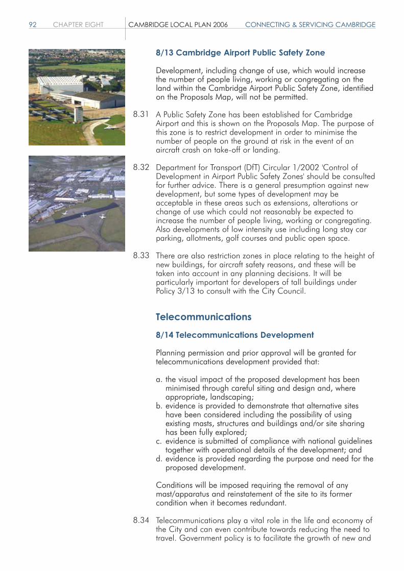
92 CHAPTER EIGHT CAMBRIDGE LOCAL PLAN 2006 CONNECTING & SERVICING CAMBRIDGE
8/13 Cambridge Airport Public Safety Zone
Development, including change of use, which would increasethe number of people living, working or congregating on theland within the Cambridge Airport Public Safety Zone, identifiedon the Proposals Map, will not be permitted.
A Public Safety Zone has been established for CambridgeAirport and this is shown on the Proposals Map. The purpose ofthis zone is to restrict development in order to minimise thenumber of people on the ground at risk in the event of anaircraft crash on take-off or landing.
Department for Transport (DfT) Circular 1/2002 'Control ofDevelopment in Airport Public Safety Zones' should be consultedfor further advice. There is a general presumption against newdevelopment, but some types of development may beacceptable in these areas such as extensions, alterations orchange of use which could not reasonably be expected toincrease the number of people living, working or congregating.Also developments of low intensity use including long stay carparking, allotments, golf courses and public open space.
There are also restriction zones in place relating to the height ofnew buildings, for aircraft safety reasons, and these will betaken into account in any planning decisions. It will beparticularly important for developers of tall buildings underPolicy 3/13 to consult with the City Council.
Telecommunications
8/14 Telecommunications Development
Planning permission and prior approval will be granted fortelecommunications development provided that:
a. the visual impact of the proposed development has been minimised through careful siting and design and, where appropriate, landscaping;
b. evidence is provided to demonstrate that alternative sites have been considered including the possibility of using existing masts, structures and buildings and/or site sharing has been fully explored;
c. evidence is submitted of compliance with national guidelines together with operational details of the development; and
d. evidence is provided regarding the purpose and need for theproposed development.
Conditions will be imposed requiring the removal of anymast/apparatus and reinstatement of the site to its formercondition when it becomes redundant.
Telecommunications play a vital role in the life and economy ofthe City and can even contribute towards reducing the need totravel. Government policy is to facilitate the growth of new and
8.31
8.32
8.33
8.34

CONNECTING & SERVICING CAMBRIDGE CAMBRIDGE LOCAL PLAN 2006 CHAPTER EIGHT 93
existing telecommunications systems whilst keeping theenvironmental impact to a minimum.
The City Council is aware of public concerns regarding healthand safety implications of telecommunications development.Current National Government guidance states that if aproposed mobile phone base station meets the InternationalCommission on Non-Ionizing Radiation Protection (ICNIRP)guidelines for public exposure, it should not be necessary for alocal planning authority to further consider concerns about itseffects on health. Account will be taken of any changes innational guidance or of the ICNIRP guidelines.
In considering applications for telecommunicationsdevelopment, regard will be had to the technical andoperational requirements and legal obligations oftelecommunications operators.
Telecommunications development will normally fall into one offour categories; de minimus, permitted development, permitteddevelopment that requires prior approval (under the GeneralPermitted Development Order, 1995) and development thatrequires an application for planning permission and/or ListedBuilding consent. Developers are encouraged to make contactwith the Local Planning Authority as early as possible in order todetermine whether the proposal is permitted development orwhether prior approval or planning permission is required.
8/15 Mullard Radio Astronomy Observatory,Lord's Bridge
Development proposals within the Lord's Bridge ConsultationAreas shown on the Proposals Map, which could adverselyaffect the operation of the Mullard Radio AstronomyObservatory will:a. be subject to consultation with the University of Cambridge;b. not be granted planning permission where undue harm
would be caused that could not be overcome by condition orplanning obligation.
The Mullard Radio Astronomy Observatory at Lord's Bridge is ofinternational importance and must be safeguarded. TheObservatory contains unique radio and optical telescopesoperated by the University of Cambridge and the University ofManchester/Jodrell Bank. The telescopes measure signals thatare very weak, and hence highly susceptible to many forms ofinterference; specifically to electrical interference, microwaveinterference from telecommunications masts and equipment,light pollution and mechanical vibration from domestic,industrial plant, and other sources such as the movement ofvehicles, including aircraft.
The Observatory is located within South Cambridgeshire DistrictCouncil, however there are two consultation areas which fallwithin the City Council boundary. The large consultation area
8.35
8.36
8.37
8.38
8.39
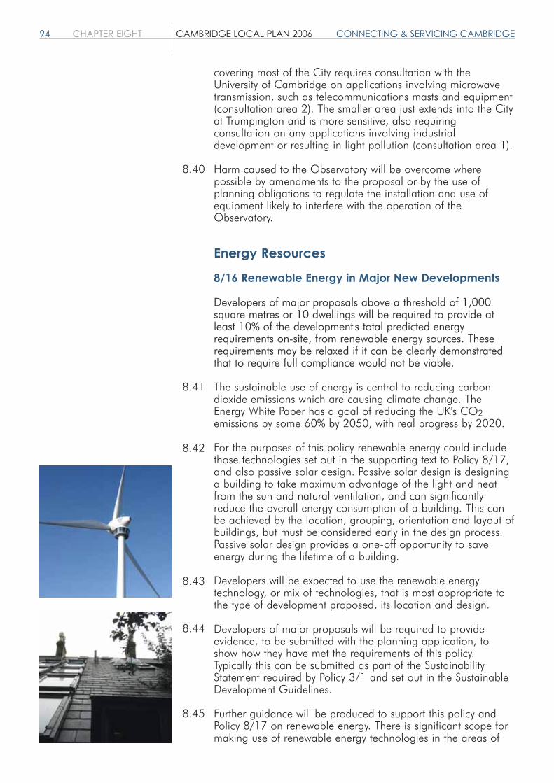
94 CHAPTER EIGHT CAMBRIDGE LOCAL PLAN 2006 CONNECTING & SERVICING CAMBRIDGE
covering most of the City requires consultation with theUniversity of Cambridge on applications involving microwavetransmission, such as telecommunications masts and equipment(consultation area 2). The smaller area just extends into the Cityat Trumpington and is more sensitive, also requiringconsultation on any applications involving industrialdevelopment or resulting in light pollution (consultation area 1).
Harm caused to the Observatory will be overcome wherepossible by amendments to the proposal or by the use ofplanning obligations to regulate the installation and use ofequipment likely to interfere with the operation of theObservatory.
Energy Resources
8/16 Renewable Energy in Major New Developments
Developers of major proposals above a threshold of 1,000square metres or 10 dwellings will be required to provide atleast 10% of the development's total predicted energyrequirements on-site, from renewable energy sources. Theserequirements may be relaxed if it can be clearly demonstratedthat to require full compliance would not be viable.
The sustainable use of energy is central to reducing carbondioxide emissions which are causing climate change. TheEnergy White Paper has a goal of reducing the UK's CO2emissions by some 60% by 2050, with real progress by 2020.
For the purposes of this policy renewable energy could includethose technologies set out in the supporting text to Policy 8/17,and also passive solar design. Passive solar design is designinga building to take maximum advantage of the light and heatfrom the sun and natural ventilation, and can significantlyreduce the overall energy consumption of a building. This canbe achieved by the location, grouping, orientation and layout ofbuildings, but must be considered early in the design process.Passive solar design provides a one-off opportunity to saveenergy during the lifetime of a building.
Developers will be expected to use the renewable energytechnology, or mix of technologies, that is most appropriate tothe type of development proposed, its location and design.
Developers of major proposals will be required to provideevidence, to be submitted with the planning application, toshow how they have met the requirements of this policy.Typically this can be submitted as part of the SustainabilityStatement required by Policy 3/1 and set out in the SustainableDevelopment Guidelines.
Further guidance will be produced to support this policy andPolicy 8/17 on renewable energy. There is significant scope formaking use of renewable energy technologies in the areas of
8.40
8.41
8.42
8.43
8.44
8.45

CONNECTING & SERVICING CAMBRIDGE CAMBRIDGE LOCAL PLAN 2006 CHAPTER EIGHT 95
major change. The City Council will require that this be fullyconsidered in the Masterplanning of these areas.
8/17 Renewable Energy
Applications for renewable energy schemes or technologies willbe permitted if applicants can demonstrate that:a. any adverse impacts to the environment or amenity have
been minimised as far as possible; andb. where any localised adverse environmental or amenity effects
remain, that these are outweighed by the wider environmental, economic or social benefits of generating energy from renewable sources.
Renewable sources of energy such as the sun, wind, waterpower, and geothermal energy can offer diversity and security ofsupply and can reduce harmful emissions to the environment.The Government's target is to generate 10% of UK electricityfrom renewable sources by 2010, with an aspiration togenerate 20% by 2020.
The City Council supports the development of renewable energyschemes. In particular the development of small-scale,community based renewable energy schemes appropriate tolocal need. The proposed urban extensions offer a significantopportunity for renewable energy schemes, however there willalso be opportunities within the rest of Cambridge. The types ofrenewable energy technologies which may be suitable include: Active solar thermal; Photovoltaic cells (PV); Wind turbines; Biomass for community heating or Combined Heat and Power
(CHP); and Ground source heat pumps.
Applicants will be required to minimise any potential impacts tothe environment or local amenity by careful site selection,choice of technologies and mitigation measures. Potentialimpacts may be acceptable if they are minor, or are outweighedby wider benefits, such as the national need for energy fromnon-fossil fuels which will contribute to reducing CO2 and otheremissions.
Other policies in the Plan deal with safeguarding theenvironment and the protection of international, national orlocally designated sites. Although such sites should be avoidedif alternative sites exist, each application will be judged on itsmerits, and renewable energy schemes are not automaticallyruled out at these sites. Renewable energy schemes will only beacceptable in the Green Belt if applicants can demonstrate thatdevelopment is appropriate, or that there are very specialcircumstances for their development in this location.
8.46
8.47
8.48
8.49
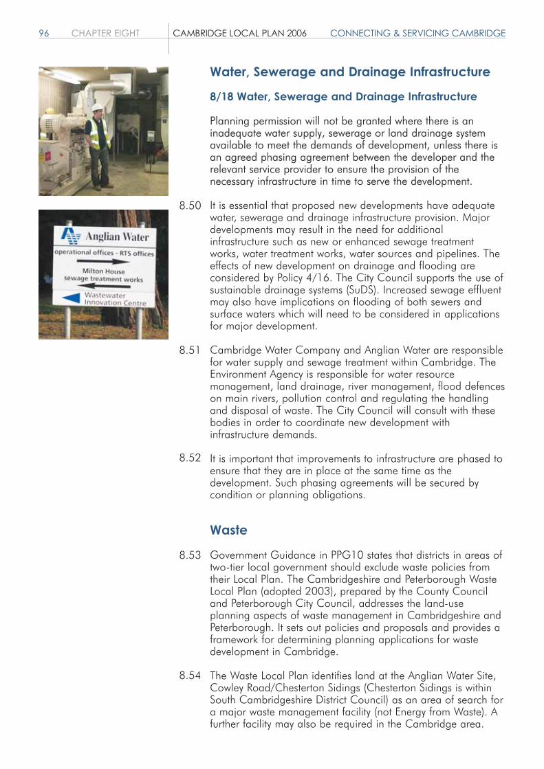
96 CHAPTER EIGHT CAMBRIDGE LOCAL PLAN 2006 CONNECTING & SERVICING CAMBRIDGE
Water, Sewerage and Drainage Infrastructure
8/18 Water, Sewerage and Drainage Infrastructure
Planning permission will not be granted where there is aninadequate water supply, sewerage or land drainage systemavailable to meet the demands of development, unless there isan agreed phasing agreement between the developer and therelevant service provider to ensure the provision of thenecessary infrastructure in time to serve the development.
It is essential that proposed new developments have adequatewater, sewerage and drainage infrastructure provision. Majordevelopments may result in the need for additionalinfrastructure such as new or enhanced sewage treatmentworks, water treatment works, water sources and pipelines. Theeffects of new development on drainage and flooding areconsidered by Policy 4/16. The City Council supports the use ofsustainable drainage systems (SuDS). Increased sewage effluentmay also have implications on flooding of both sewers andsurface waters which will need to be considered in applicationsfor major development.
Cambridge Water Company and Anglian Water are responsiblefor water supply and sewage treatment within Cambridge. TheEnvironment Agency is responsible for water resourcemanagement, land drainage, river management, flood defenceson main rivers, pollution control and regulating the handlingand disposal of waste. The City Council will consult with thesebodies in order to coordinate new development withinfrastructure demands.
It is important that improvements to infrastructure are phased toensure that they are in place at the same time as thedevelopment. Such phasing agreements will be secured bycondition or planning obligations.
Waste
Government Guidance in PPG10 states that districts in areas oftwo-tier local government should exclude waste policies fromtheir Local Plan. The Cambridgeshire and Peterborough WasteLocal Plan (adopted 2003), prepared by the County Counciland Peterborough City Council, addresses the land-useplanning aspects of waste management in Cambridgeshire andPeterborough. It sets out policies and proposals and provides aframework for determining planning applications for wastedevelopment in Cambridge.
The Waste Local Plan identifies land at the Anglian Water Site,Cowley Road/Chesterton Sidings (Chesterton Sidings is withinSouth Cambridgeshire District Council) as an area of search fora major waste management facility (not Energy from Waste). Afurther facility may also be required in the Cambridge area.
8.50
8.51
8.52
8.53
8.54

CONNECTING & SERVICING CAMBRIDGE CAMBRIDGE LOCAL PLAN 2006 CHAPTER EIGHT 97
There may be potential to provide a major waste managementfacility as part of a major new development (see Waste LocalPlan Policy WLP18). Any proposal will need to be in accordancewith the policies in the Waste Local Plan and policies in theLocal Plan.
In addition, the Waste Local Plan has indicated that there is aneed to identify land for Household Waste Recycling Centres(HWRC) in the Cambridge City area. This is particularly thecase because the only current site serving Cambridge, atMilton, is temporary.
The requirements for new facilities are being considered in theemerging Cambridgeshire and Peterborough Minerals andWaste Development Plan, which is the relevant document toestablish the number and siting of facilities. Future wastemanagement sites will need to be carefully designed to co-existwith neighbouring uses.
8.55
8.56
8.57


AREAS OF MAJOR CHANGE CAMBRIDGE LOCAL PLAN 2006 CHAPTER NINE 99
AREAS OF MAJOR CHANGEObjectives
1. To provide a framework for the delivery of major development in and around Cambridge.
2. To establish an overall vision for each of the Areas of Major Change and set out principles to guide the preparation of further guidance for these areas.
Introduction
This chapter contains policies relating to the planning anddevelopment of urban extensions around the edge of theexisting built-up area of Cambridge as well as land aroundCambridge station, collectively referred to as Areas of MajorChange. These areas are shown on the proposals map andinclude:
East Cambridge; Southern Fringe; Northern Fringe; Madingley Road/Huntingdon Road; Huntingdon Road/Histon Road; and Station Area.
These areas will see significant development during the periodof the Local Plan providing much needed housing andassociated community facilities, as well as land for employment,medical and higher education expansion. Such a scale ofdevelopment and change needs to be carefully planned for andmanaged. The policies in this chapter are the first steps inachieving this.
General policies for all Areas of Major Change are included atthe beginning of this chapter, followed by a policy that appliesto all urban extensions and finally there are a number of site-specific policies relating to each Area of Major Change. Thenon site-specific policies of the Local Plan continue to apply.The indicative dwelling capacities quoted illustrate the likelycapacity of each area, actual capacities may be higher or lowerdepending upon their detailed Masterplanning.
9/1 Further Policy/Guidance for the Development ofAreas of Major Change
Further policy/guidance for Areas of Major Change and otherlarge or complex sites will be prepared in partnership withCambridgeshire County Council, South Cambridgeshire DistrictCouncil, landowners and developers as appropriate, and withpublic consultation. Substantive development will not be
9.1
9.2
9.3

100 CHAPTER NINE CAMBRIDGE LOCAL PLAN 2006 AREAS OF MAJOR CHANGE
permitted in advance of the preparation and approval of furtherpolicy/guidance. Limited development may be permitted,providing it would not prejudice the longer-term development ofthe Area of Major Change and is not considered to be prematurein advance of the preparation of further policy/guidance.
The City Council wishes to ensure that the Areas of MajorChange identified in paragraph 9.1 and any other large orcomplex sites that come forward for development, are developedin the most appropriate way taking account of the sustainability,mixed use and design objectives set out elsewhere in the Plan.
As a first step, this Plan includes site-specific policies for each ofthe Areas of Major Change. These policies set the broadframework for development and specify the principal land uses,accessibility considerations and landscape requirements for eacharea.
However, more detailed policy/guidance will need to be preparedfor each of these sites. This policy seeks to ensure the timelypreparation of appropriate guidance and aims to ensure thatdevelopment of these large and complex sites is in accordancewith this guidance.
The form of this policy/guidance will vary from site to sitedepending on a variety of factors such as the time at which theland comes forward for development and the extent to which thesite crosses the boundary with South Cambridgeshire. Thispolicy/guidance might include Masterplans, and LocalDevelopment Documents including Area Action Plans andSupplementary Planning Documents, as appropriate to the site inquestion. Subsequent planning applications should conform withapproved guidance.
The City Council believes that it is important that it engages withkey partners including the local community, SouthCambridgeshire District Council and the County Council, in thepreparation of this detailed policy/guidance. Where sites cross theadministrative boundary into South Cambridgeshire District,proposals will need to take account of policies from all relevantplans.
In order to ensure that the development of these sites isundertaken in a comprehensive, coordinated manner, substantivedevelopment will not be permitted until the more detailedpolicy/guidance for that site as a whole has been approved.However, limited development which would not prejudice thelonger-term development of the site and which is not consideredto be premature in advance of the preparation of furtherpolicy/guidance may be permitted.
The City Council will also actively promote with key partners theproduction of further policy/guidance for any other large orcomplex sites within the urban area, which come forward fordevelopment. Subsequent planning applications will be expectedto be in accordance with the approved documents.
9.4
9.5
9.6
9.7
9.8
9.9
9.10
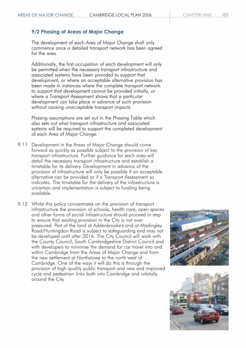
AREAS OF MAJOR CHANGE CAMBRIDGE LOCAL PLAN 2006 CHAPTER NINE 101
9/2 Phasing of Areas of Major Change
The development of each Area of Major Change shall onlycommence once a detailed transport network has been agreedfor the area.
Additionally, the first occupation of each development will onlybe permitted when the necessary transport infrastructure andassociated systems have been provided to support thatdevelopment, or where an acceptable alternative provision hasbeen made in instances where the complete transport networkto support that development cannot be provided initially, orwhere a Transport Assessment shows that a particulardevelopment can take place in advance of such provisionwithout causing unacceptable transport impacts.
Phasing assumptions are set out in the Phasing Table whichalso sets out what transport infrastructure and associatedsystems will be required to support the completed developmentof each Area of Major Change.
Development in the Areas of Major Change should comeforward as quickly as possible subject to the provision of keytransport infrastructure. Further guidance for each area willdetail the necessary transport infrastructure and establish atimetable for its delivery. Development in advance of theprovision of infrastructure will only be possible if an acceptablealternative can be provided or if a Transport Assessment soindicates. The timetable for the delivery of the infrastructure isuncertain and implementation is subject to funding beingavailable.
Whilst this policy concentrates on the provision of transportinfrastructure the provision of schools, health care, open spacesand other forms of social infrastructure should proceed in stepto ensure that existing provision in the City is not overpressured. Part of the land at Addenbrooke's and at MadingleyRoad/Huntingdon Road is subject to safeguarding and may notbe developed until after 2016. The City Council will work withthe County Council, South Cambridgeshire District Council andwith developers to minimise the demand for car travel into andwithin Cambridge from the Areas of Major Change and fromthe new settlement at Northstowe to the north west ofCambridge. One of the ways it will do this is through theprovision of high quality public transport and new and improvedcycle and pedestrian links both into Cambridge and orbitallyaround the City.
9.11
9.12
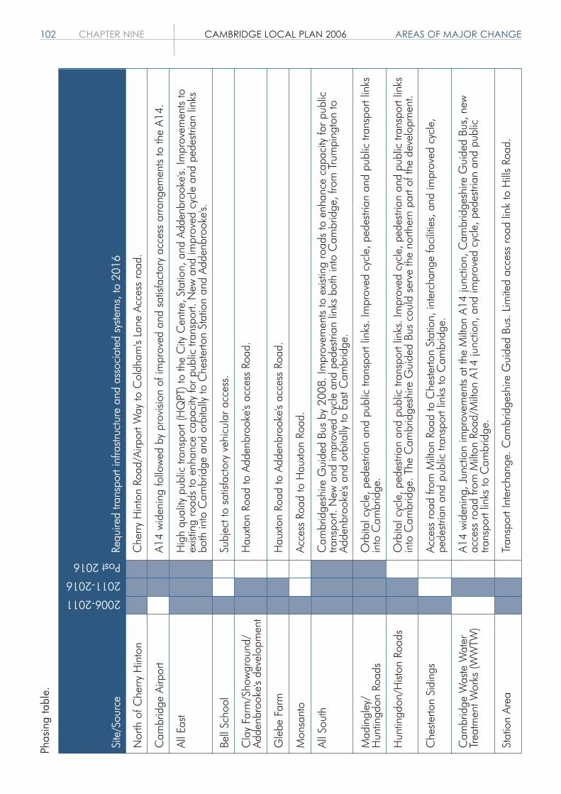
102 CHAPTER NINE CAMBRIDGE LOCAL PLAN 2006 AREAS OF MAJOR CHANGEPh
asin
g ta
ble.
Nor
th o
f Che
rry H
into
n
Cam
brid
ge A
irpor
t
All E
ast
Bell
Scho
ol
Cla
y Fa
rm/S
how
grou
nd/
Adde
nbro
oke'
s de
velo
pmen
t
Gle
be F
arm
Mon
sant
o
All S
outh
Mad
ingl
ey/
Hun
tingd
on R
oads
Hun
tingd
on/H
iston
Roa
ds
Che
sterto
n Si
ding
s
Cam
brid
ge W
aste
Wat
erTr
eatm
ent W
orks
(WW
TW)
Stat
ion
Area
2006-2011
2011-2016
Post 2016
Che
rry H
into
n Ro
ad/A
irpor
t Way
to C
oldh
am's
Lane
Acc
ess
road
.
A14
wid
enin
g fo
llow
ed b
y pr
ovisi
on o
f im
prov
ed a
nd s
atisf
acto
ry a
cces
s ar
rang
emen
ts to
the
A14.
Hig
h qu
ality
pub
lic tr
ansp
ort (
HQ
PT) t
o th
e C
ity C
entre
, Sta
tion,
and
Add
enbr
ooke
's. Im
prov
emen
ts to
exist
ing
road
s to
enh
ance
cap
acity
for p
ublic
tran
spor
t. N
ew a
nd im
prov
ed c
ycle
and
ped
estri
an li
nks
both
into
Cam
brid
ge a
nd o
rbita
lly to
Che
sterto
n St
atio
n an
d Ad
denb
rook
e's.
Subj
ect t
o sa
tisfa
ctor
y ve
hicu
lar a
cces
s.
Hau
xton
Roa
d to
Add
enbr
ooke
's ac
cess
Roa
d.
Hau
xton
Roa
d to
Add
enbr
ooke
's ac
cess
Roa
d.
Acce
ss R
oad
to H
auxt
on R
oad.
Cam
brid
gesh
ire G
uide
d Bu
s by
200
8. Im
prov
emen
ts to
exis
ting
road
s to
enh
ance
cap
acity
for p
ublic
trans
port.
New
and
impr
oved
cyc
le a
nd p
edes
trian
link
s bo
th in
to C
ambr
idge
, fro
m T
rum
ping
ton
toAd
denb
rook
e's
and
orbi
tally
to E
ast C
ambr
idge
.
Orb
ital c
ycle
, ped
estri
an a
nd p
ublic
tran
spor
t lin
ks. I
mpr
oved
cyc
le, p
edes
trian
and
pub
lic tr
ansp
ort l
inks
into
Cam
brid
ge.
Orb
ital c
ycle
, ped
estri
an a
nd p
ublic
tran
spor
t lin
ks. I
mpr
oved
cyc
le, p
edes
trian
and
pub
lic tr
ansp
ort l
inks
into
Cam
brid
ge. T
he C
ambr
idge
shire
Gui
ded
Bus
coul
d se
rve
the
north
ern
part
of th
e de
velo
pmen
t.
Acce
ss ro
ad fr
om M
ilton
Roa
d to
Che
sterto
n St
atio
n, in
terc
hang
e fa
cilit
ies,
and
impr
oved
cyc
le,
pede
stria
n an
d pu
blic
tran
spor
t lin
ks to
Cam
brid
ge.
A14
wid
enin
g, J
unct
ion
impr
ovem
ents
at th
e M
ilton
A14
junc
tion,
Cam
brid
gesh
ire G
uide
d Bu
s, n
ewac
cess
road
from
Milt
on R
oad/
Milt
on A
14 ju
nctio
n, a
nd im
prov
ed c
ycle
, ped
estri
an a
nd p
ublic
trans
port
links
to C
ambr
idge
.
Tran
spor
t Int
erch
ange
. Cam
brid
gesh
ire G
uide
d Bu
s. L
imite
d ac
cess
road
link
to H
ills
Road
.
Site
/Sou
rce
Requ
ired
trans
port
infra
struc
ture
and
ass
ocia
ted
syste
ms,
to 2
016

AREAS OF MAJOR CHANGE CAMBRIDGE LOCAL PLAN 2006 CHAPTER NINE 103
9/3 Development in the Urban Extensions
The development of the urban extensions will:a. create attractive, stimulating, socially inclusive and safe living
and working environments with distinctive characters incorporating high quality design sensitively integrated with existing communities;
b. enhance the setting and character of Cambridge;c. respect key views and create new vistas;d. develop a new, strong landscape framework which is guided
by existing and historic character and positive features (wherepracticable, structural landscaping should be created at an early date and allowed time to mature before development commences);
e. provide open space linking in to the existing open space network to help conserve the setting of the City and provide recreation opportunities;
f. develop a biodiversity framework within the landscape framework and open space provision;
g. have higher densities around key transport nodes (including the proposed Chesterton Railway Station), and in the case of East Cambridge, a new District Centre;
h. ensure that the site is fully integrated into transport networks and is served by High Quality Public Transport Services;
i. create a comprehensive network of footpaths and cycle routes and link these into the wider network to allow these modes of transport to have a high modal share;
j. include a mix of uses within Classes A1, A2, A3, A4 and A5,providing it is of an appropriate nature and scale to its location, catering only for local needs, and that it would not have an adverse impact on the vitality and viability of the City Centre or District and Local Centres;
k. include community facilities appropriate to the development, and located, where appropriate, to integrate well with existing communities;
l. where appropriate use innovative construction methods, technologies and layouts to maximise the use of the available land;
m. incorporate Sustainable Drainage Systems where practicable;and
n. incorporate renewable energy technologies.
Planning obligations will be used as a mechanism by which theprovision of and contributions towards, affordable housing,transport infrastructure, recreation and open space, educationand lifelong learning, community facilities, nature conservation,renewable energy and public art will be secured. A keyrequirement will be long term agreements on the managementof the strategic open space and public access into thecountryside.
The actual housing capacity of each area will be establishedduring the preparation of the Masterplan.
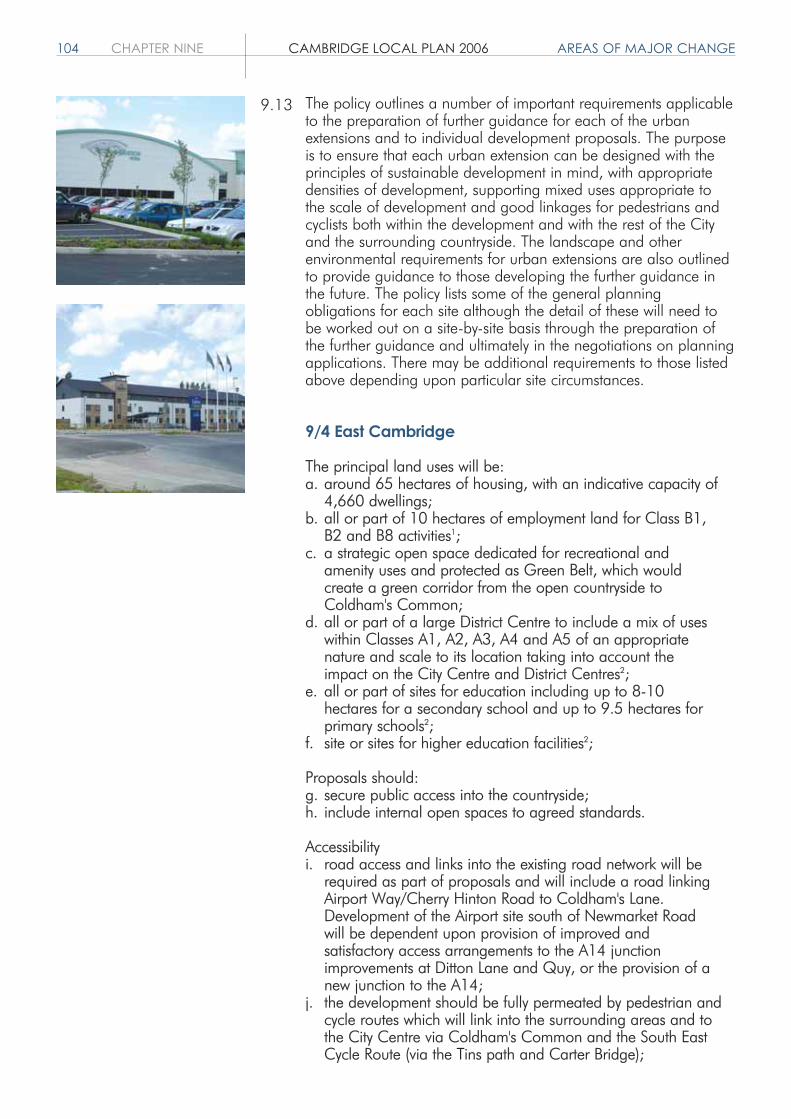
104 CHAPTER NINE CAMBRIDGE LOCAL PLAN 2006 AREAS OF MAJOR CHANGE
The policy outlines a number of important requirements applicableto the preparation of further guidance for each of the urbanextensions and to individual development proposals. The purposeis to ensure that each urban extension can be designed with theprinciples of sustainable development in mind, with appropriatedensities of development, supporting mixed uses appropriate tothe scale of development and good linkages for pedestrians andcyclists both within the development and with the rest of the Cityand the surrounding countryside. The landscape and otherenvironmental requirements for urban extensions are also outlinedto provide guidance to those developing the further guidance inthe future. The policy lists some of the general planningobligations for each site although the detail of these will need tobe worked out on a site-by-site basis through the preparation ofthe further guidance and ultimately in the negotiations on planningapplications. There may be additional requirements to those listedabove depending upon particular site circumstances.
9/4 East Cambridge
The principal land uses will be:a. around 65 hectares of housing, with an indicative capacity of
4,660 dwellings;b. all or part of 10 hectares of employment land for Class B1,
B2 and B8 activities1;c. a strategic open space dedicated for recreational and
amenity uses and protected as Green Belt, which would create a green corridor from the open countryside to Coldham's Common;
d. all or part of a large District Centre to include a mix of uses within Classes A1, A2, A3, A4 and A5 of an appropriate nature and scale to its location taking into account the impact on the City Centre and District Centres2;
e. all or part of sites for education including up to 8-10 hectares for a secondary school and up to 9.5 hectares for primary schools2;
f. site or sites for higher education facilities2;
Proposals should:g. secure public access into the countryside;h. include internal open spaces to agreed standards.
Accessibilityi. road access and links into the existing road network will be
required as part of proposals and will include a road linking Airport Way/Cherry Hinton Road to Coldham's Lane. Development of the Airport site south of Newmarket Road will be dependent upon provision of improved and satisfactory access arrangements to the A14 junction improvements at Ditton Lane and Quy, or the provision of a new junction to the A14;
j. the development should be fully permeated by pedestrian and cycle routes which will link into the surrounding areas and to the City Centre via Coldham's Common and the South East Cycle Route (via the Tins path and Carter Bridge);
9.13

AREAS OF MAJOR CHANGE CAMBRIDGE LOCAL PLAN 2006 CHAPTER NINE 105
k. high accessibility (400 metre maximum walking catchments) to high quality public transport systems is required on both radial and orbital routes (linking to the Northern Fringe and Addenbrooke's); and
l. a segregated public transport route through the site isrequired linking into the existing network.
1 20-25 hectares or 4-5,000 jobs are proposed in the East Area Action PlanPreferred Options for the area as a whole, of which 10ha comes from theStructure Plan guidelines for the City. This 10ha could be located in the Cityor South Cambridgeshire and will be determined through Masterplanningand the detailed planning application stage.2 to be located in Cambridge City or South Cambridgeshire dependent uponthe Masterplanning.
The extent of the future development on the east of the Citymust not be underestimated: the capacity of the land within theCity and in South Cambridgeshire represents a commitment tothe largest single area of growth within the Sub-region duringthe current round of plan making. Development on this scalewill bring with it both the need for a comprehensive range ofland uses and services and an opportunity to attract facilitiesthat are currently missing from the Cambridge area.
The whole area potentially available for development straddlesthe City – South Cambridgeshire boundary. Creating asuccessful and sustainable urban extension will require planningacross the whole area and this will be the subject of a jointArea Action Plan that will provide comprehensive guidance ondevelopment principles, land uses, infrastructure, design andphasing. Policy 9/4 sets down some of the principles, withoutbeing too prescriptive thereby allowing the Area Action Plan toconsider the best distribution of uses across the area.
The vision for East Cambridge is to create a distinctive majornew urban extension to the City achieving the highest quality ofdesign and embodying the principles of sustainability.Development of this site will help to meet the housing needs ofthe City, providing around 4,660 dwellings by being developedat a high density. Further dwellings may be achievable in SouthCambridgeshire to the north of Newmarket Road, on the Airportand to the north of Cherry Hinton. In addition, some land mustbe reserved within the development area for employment as thesite is identified in the Structure Plan as a Strategic EmploymentAllocation. The new extension will include a large district centrewith an appropriate level of shops and services for the scale ofdevelopment. The centre and other sites may include civic uses,a conference centre and leisure development that will meetSub-regional needs and help in developing the regional role ofthe City.
A key feature of the development will be the creation of a greencorridor running through the Airport site and linking Coldham'sCommon with the open countryside in South Cambridgeshire.Its location will be identified through subsequentMasterplanning. The green corridor will be protected from
9.14
9.15
9.16
9.17

106 CHAPTER NINE CAMBRIDGE LOCAL PLAN 2006 AREAS OF MAJOR CHANGE
development and is expected to be dedicated for public accessand recreation. It will be protected by maintaining it as GreenBelt.
The total area of the site within the City and including the SouthWorks is 114.89 hectares.
The site is constrained. Key issues to be taken into accountinclude the need to relocate the airport and airport relatedactivities of Marshall of Cambridge. Relocation costs will betaken into account in decisions on the level of the planninggains to be incorporated into the Section 106 Agreement. Thetraffic demands of such a large development will need to bemet by the provision of high quality walking, cycling and publictransport networks to minimise the increase in the number ofadditional vehicles on the network. The sensitive relationshipwith open countryside and the villages to the east will alsorequire careful design and management. There is a DefinitiveRight of Way between Church End and Airport Way.
The development of East Cambridge will be undertaken inpartnership with landowners and developers to achieve anattractive, well-integrated and sustainable extension toCambridge. The joint Area Action Plan, prepared in conjunctionwith South Cambridgeshire District Council, will be crucial inguiding the implementation of this urban extension.
Figure 9/4 provides a diagrammatic representation of theprincipal land uses, access and transport arrangements andlandscape requirements for East Cambridge. This figure isinformal guidance to help with the understanding of the policyand does not have the formal status of the Proposals Map itself.
9/5 Southern Fringe
The principal land uses will be:a. around 65 hectares of housing, indicative capacity 3,320
dwellings; b. leisure and recreation facilities;c. education including up to 4.5 hectares for primary schools,
and a site for a secondary school, if Cambridgeshire County Council, as the local children's service authority, adequately demonstrates that there is an educational need for this provision in the Southern Fringe;
d. up to 10.3 hectares for NHS and private clinical development. 2.2 hectares of this area is reserved for the possible relocation of Papworth hospital. In the event of it not being needed for this use it would be available for other clinical, higher education, or sui generis medical research institutes;
e. up to 10.28 hectares of land will be safeguarded until after 2016 for future clinical development and research uses, the respective proportions being determined at Plan Review;
9.18
9.19
9.20
9.21

AREAS OF MAJOR CHANGE CAMBRIDGE LOCAL PLAN 2006 CHAPTER NINE 107
Newmarket Road
Park&
Ride
Coldhams Lane
Airp
ort W
ay
Barn
we
l l R
oad
m'sn
( D I A G R A M M A T I C )
Green Corridor / Green Belt
Residential
Residential in SCDC
Green Corridor / Green Belt in SCDC
Diagrammatic representation of the principal land uses, access and transport arrangements and landscape requirements.
© Crown Copyright (Licence No. 100019730)
Figure: 9/4 East Cambridge.

108 CHAPTER NINE CAMBRIDGE LOCAL PLAN 2006 AREAS OF MAJOR CHANGE
f. up to 14.4 hectares of employment land for commercial development, comprising biomedical and biotechnology research and development activities within Class B1(b), related support activities, related higher education and sui generis medical research institutes. A Section 106 Agreementwill be used to ensure occupation accords with this mix of uses;
g. consolidation of local shopping and services in Trumpington centre and local neighbourhood shopping in areas of new development;
h. a large-scale public open space of City-wide importance will be provided.
Proposals should:i. retain and enhance the strategic green corridor that extends
from the chalk hills to Long Road along the Vicar's Brook, Hobson's Brook corridor and retain the nature and character of the two watercourses;
j. respect key views, especially to and from the chalk hills and create new vistas;
k. create distinctive gateways to the City when approached by road and rail;
l. mitigate for the potential disruption of the green wedge from transport routes;
m.respect and incorporate existing brooks, hedgerows and shelterbelts.
Accessibilityn. development in the Southern Fringe must be linked effectively
to the wider road network. Key elements of the new highway infrastructure will be a southern access road to Addenbrooke's Hospital from the Hauxton Road, with no direct link through to Babraham Road; a link into Clay Farm from Long Road, but not providing a through route; access to the Bell site from Babraham Road; access to the Monsanto site from Hauxton Road, probably at the junction of the new southern access road; and access to the Glebe Farm site from the southern access road. In addition, the possibility of a link into Clay Farm from the west should be investigated and provided if feasible;
o. the individual development areas will be fully permeated by pedestrian and cycle routes. The development areas will also be linked, especially east-west;
p. strategic cycle routes northward linking up to Long Road andthe National Cycle Network Route 11 and along the Cambridgeshire Guided Bus Route will be provided;
q. improvements to the east-west cycle route will be required to link the new residential areas in Trumpington with Addenbrooke's and beyond;
r. existing conventional bus services and Park and Ride serviceswill be expanded and extended to meet the needs of the resident and working population; and
s. the proposed Cambridgeshire Guided Bus will serve the areafrom the north along the old Bedford railway line, with spurs to Addenbrooke's Hospital and the Trumpington Park and Ride site.

AREAS OF MAJOR CHANGE CAMBRIDGE LOCAL PLAN 2006 CHAPTER NINE 109
The vision for the Southern Fringe is to create a distinctive newurban extension to the City to meet a range of needs for theCambridge area, including additional housing close to an existingemployment area, new employment opportunities, the expansionof clinical facilities and biomedical and biotechnology activities,related higher education and research institutes, and improvedaccess to the countryside. The extension will incorporate strategicopen space to serve the residents of the new development,Cambridge City and South Cambridgeshire and opportunities willbe taken to enhance amenity, biodiversity and access to the GreenBelt. The provision of shops and services in the existing area ofTrumpington will be consolidated although there may be scope forsome small neighbourhood facilities within the areas of newdevelopment. However, the search for a secondary school site mayneed to extend beyond the boundaries of the Southern Fringe Areaof Major Change as defined on the Proposals Map. This is anexciting opportunity to create an example of best practice insustainable development.
Five main areas of land will be developed. East of Shelford Roadand Clay Farm (sites 9.05 and 9.06) – 31.38 ha and 29.31 harespectively will be primarily for residential development with openspace. The Addenbrooke's site (site 9.02) is 57.93 ha in total, andwill be primarily for clinical development and biomedical andbiotechnology research and development activities, related supportactivities; related higher education and sui generis researchinstitutes. 10.28 ha of land south of the main Addenbrooke's sitewill be safeguarded for future clinical development and as anextension to the research area post 2016 (site 9.09). 7.61 ha ofland south of the Bell School (site 9.12), 9.79 ha of land at GlebeFarm (site 9.13), and 15.5 ha of land at Monsanto (site 9.08), willbe primarily for residential development.
The research area is a commercial development within theCambridge Biomedical Campus at Addenbrooke's. It aims toprovide specialist premises to reinforce the existing biomedical andbiotechnology cluster in the Cambridge area. It has potential togain advantage from its proximity to the hospital, University andother internationally important research institutes nearby. Inplanning terms the mix of uses should focus primarily upongenuine B1 (b) research and development uses and sui generisresearch institutes. It is to be marketed towards firms from thebiotechnology, pharmaceutical and medical device and equipmentsectors. Related support activities are also acceptable on anappropriate scale. These activities might include patent agents,venture capital firms, marketing and sales activities, providedindividual premises do not exceed 500 sq metres and such usesprovide evidence that they support other clinical and research anddevelopment tenants on the site. A condition or legal agreementwill be used to ensure future occupation accords with this mix ofuses.
The development of the Southern Fringe will be undertaken inpartnership with landowners and developers to achieve anattractive, well-integrated and sustainable extension to Cambridge.
9.22
9.23
9.24
9.25

110 CHAPTER NINE CAMBRIDGE LOCAL PLAN 2006 AREAS OF MAJOR CHANGE
Key features to be taken into account include Hobson's Brookand other features important for biodiversity, existing trees, andthe sensitive transition between the urban fringe and theattractive open countryside that rises up to the south.
Figure 9/5 provides a diagrammatic representation of theprincipal land uses, access and transport arrangements andlandscape requirements for the Southern Fringe. This figure isinformal guidance to help with the understanding of the policyand does not have the formal status of the Proposals Map itself.
9/6 Northern Fringe
The principal land uses will be:a. around 35 hectares of housing, indicative capacity 2,300
dwellings;b. 6.0 hectares of land for mixed commercial uses including up
to 2 hectares for B1, B2 and B8 employment uses;c. 0.5 hectares retail;d. 5.4 hectares for community facilities including up to 3
hectares for primary school(s); e. 4 hectares for relocated aggregates works;f. formal public open space in accordance with open space
standards;g. 2 hectares for a Major Waste Management Facility;h. 1 hectare for a Household Waste Recycling Centre.
Proposals should:i. pay particular regard to the relationship between the edge of
development, Chesterton and the River Cam corridor.
Accessibilityj. development at Chesterton Sidings will be accessed from
Milton Road, with an additional new access road to the remainder of the development from Milton Road/Milton A14 junction and improved linkages to Chesterton;
k. proposals should strengthen pedestrian and cycle links to Cambridge Science Park across Milton Road, Chesterton andto the River Cam;
l. existing conventional bus services will be expanded and improved as part of any development proposals. The Park and Ride site may be relocated if a suitable alternative site is found;
m.development proposals will be served by the CambridgeshireGuided Bus, which will follow the route of the former St Ives railway line;
n. proposals for a railway station at Chesterton Sidings are considered a high priority. Although the site for the station isbeyond the City boundary, access to the station will be through land within the City boundary;
o. an integrated transport interchange to cater for rail, Cambridgeshire Guided Bus, buses, taxis, cycles and pedestrians will be included; and
p. development should not preclude the possibility of creating links to East Cambridge in the long term.
9.26
9.27

AREAS OF MAJOR CHANGE CAMBRIDGE LOCAL PLAN 2006 CHAPTER NINE 111
Trumpington Road
Lo
ng
Ro
ad
GU
IDED BUS
AD
DE
NB
RO
OK
E'S
Bab
rah
am
Ro
ad
Railway Line
H obsons Bro ok
Shelford
Road
Hauxton Road
Gre
en
Belt
Resid
en
tial
Clin
ical S
erv
ices /
Bio
medic
al R
esearc
h / M
RC
Resid
en
tial in
SC
DC
Clin
ical S
erv
ices /
Bio
medic
al R
esearc
h (A
fter
2016)
Tru
mp
ingto
n V
illage C
en
tre
Ke
y I
ndic
ative R
oa
d L
inks
Guid
ed B
us
Dia
gram
mat
ic r
epre
sent
atio
n of
the
prin
cipa
l lan
d us
es,
acce
ss a
nd tr
ansp
ort a
rran
gem
ents
and
land
scap
e re
quire
men
ts.
© C
row
n C
opyr
ight
(Lic
ence
No.
100
0197
30)
Figure: 9/5 Southern Fringe.
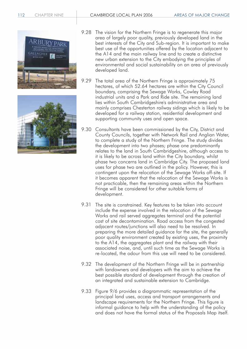
112 CHAPTER NINE CAMBRIDGE LOCAL PLAN 2006 AREAS OF MAJOR CHANGE
The vision for the Northern Fringe is to regenerate this majorarea of largely poor quality, previously developed land in thebest interests of the City and Sub-region. It is important to makebest use of the opportunities offered by the location adjacent tothe A14 and the main railway line and to create a distinctivenew urban extension to the City embodying the principles ofenvironmental and social sustainability on an area of previouslydeveloped land.
The total area of the Northern Fringe is approximately 75hectares, of which 52.64 hectares are within the City Councilboundary, comprising the Sewage Works, Cowley Roadindustrial units and a Park and Ride site. The remaining landlies within South Cambridgeshire's administrative area andmainly comprises Chesterton railway sidings which is likely to bedeveloped for a railway station, residential development andsupporting community uses and open space.
Consultants have been commissioned by the City, District andCounty Councils, together with Network Rail and Anglian Water,to complete a study of the Northern Fringe. The study dividesthe development into two phases; phase one predominantlyrelates to the land in South Cambridgeshire, although access toit is likely to be across land within the City boundary, whilstphase two concerns land in Cambridge City. The proposed landuses for phase two are outlined in the policy. However, this iscontingent upon the relocation of the Sewage Works off-site. Ifit becomes apparent that the relocation of the Sewage Works isnot practicable, then the remaining areas within the NorthernFringe will be considered for other suitable forms ofdevelopment.
The site is constrained. Key features to be taken into accountinclude the expense involved in the relocation of the SewageWorks and rail served aggregates terminal and the potentialcost of site decontamination. Road access from the congestedadjacent routes/junctions will also need to be resolved. Inpreparing the more detailed guidance for the site, the generallypoor quality environment created by existing uses, the proximityto the A14, the aggregates plant and the railway with theirassociated noise, and, until such time as the Sewage Works isre-located, the odour from this use will need to be considered.
The development of the Northern Fringe will be in partnershipwith landowners and developers with the aim to achieve thebest possible standard of development through the creation ofan integrated and sustainable extension to Cambridge.
Figure 9/6 provides a diagrammatic representation of theprincipal land uses, access and transport arrangements andlandscape requirements for the Northern Fringe. This figure isinformal guidance to help with the understanding of the policyand does not have the formal status of the Proposals Map itself.
9.28
9.29
9.30
9.31
9.32
9.33
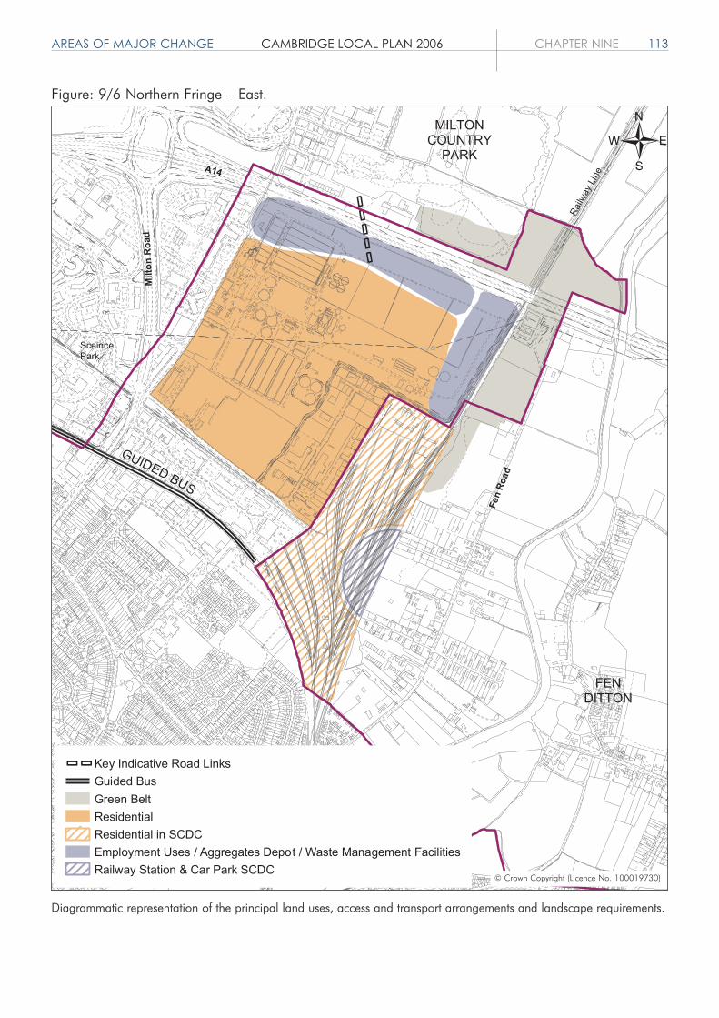
AREAS OF MAJOR CHANGE CAMBRIDGE LOCAL PLAN 2006 CHAPTER NINE 113
GUIDED BUS
Railw
ay
Lin
e
MILTONCOUNTRY
PARK
Fen R
oad
FENDITTON
River Cam
A14
Milto
n R
oad
SceincePark
Key Indicative Road Links
Guided Bus
Green Belt
Residential
Residential in SCDC
Employment Uses / Aggregates Depot / Waste Management Facilities
Railway Station & Car Park SCDC
Diagrammatic representation of the principal land uses, access and transport arrangements and landscape requirements.
© Crown Copyright (Licence No. 100019730)
Figure: 9/6 Northern Fringe – East.

114 CHAPTER NINE CAMBRIDGE LOCAL PLAN 2006 AREAS OF MAJOR CHANGE
9/7 Land between Madingley Roadand Huntingdon Road
Land between Madingley Road and Huntingdon Road isreserved for predominantly University of Cambridge relateduses. In considering what is appropriate development, regardwill be had to the Structure Plan and other Local Plan policiesand to whether Cambridge University can show a clear need forthe land to be released. In respect of Collegiate developmentfor staff and student accommodation and University academicfaculty development, such evidence will also need to show thatthere is no available alternative land allocated for these useselsewhere in Cambridge.
Land not required for development until after 2016 will besafeguarded for the uses set out in this policy.
The whole site straddles the City-South Cambridgeshireboundary and the phasing of development will be established ina site-wide Masterplan and Area Action Plan. However, site9.11 can be brought forward for development at any time andthe development of site 9.07 should take place only when theUniversity can show a clear need for the land to be released (asdefined above).
The principal land uses will be:a. up to 26 hectares of housing, indicative capacity 1,150
dwellings. 50% of this should be key worker housing for the University or College staff, but account will be taken of the viability of the development, any particular costs associated with the development and whether there are other planning objectives which need to be given priority. Compliance with this requirement will satisfy the requirements for the provisionof affordable housing set out in Policy 5/5;
b. up to 14 hectares for higher education, including new Collegiate provision, academic faculty development, student accommodation, University conference centre;
c. all or part of a site for education including up to 1.5 hectares for a primary school1;
d. up to 6 hectares for University related sui generis research institutes and commercial research uses within Use Class B1(b);
e. all or part of a site for a local centre to include a mix of useswithin Classes A1, A2 and A3, of an appropriate scale to its location taking into account other Local and District Centres;
f. public open space.
Proposals should:g. provide an open space buffer in order to respect the setting
of Girton and avoid development which causes coalescence with the City. This should link with the strategic gap (part of which is designated Green Belt) which straddles Huntingdon Road between Girton and Cambridge;
h. provide a radial green corridor into Cambridge;
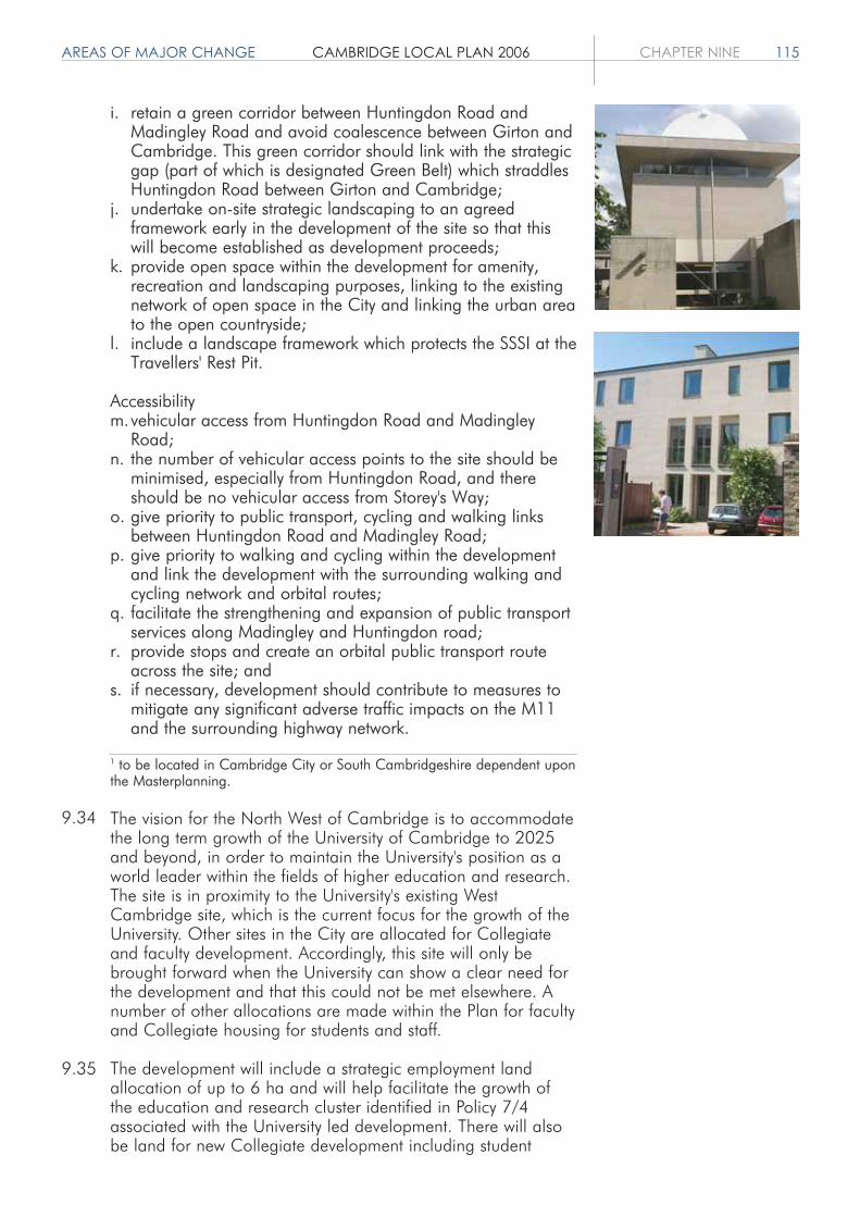
AREAS OF MAJOR CHANGE CAMBRIDGE LOCAL PLAN 2006 CHAPTER NINE 115
i. retain a green corridor between Huntingdon Road and Madingley Road and avoid coalescence between Girton andCambridge. This green corridor should link with the strategic gap (part of which is designated Green Belt) which straddles Huntingdon Road between Girton and Cambridge;
j. undertake on-site strategic landscaping to an agreed framework early in the development of the site so that this will become established as development proceeds;
k. provide open space within the development for amenity, recreation and landscaping purposes, linking to the existing network of open space in the City and linking the urban areato the open countryside;
l. include a landscape framework which protects the SSSI at theTravellers' Rest Pit.
Accessibilitym.vehicular access from Huntingdon Road and Madingley
Road;n. the number of vehicular access points to the site should be
minimised, especially from Huntingdon Road, and there should be no vehicular access from Storey's Way;
o. give priority to public transport, cycling and walking links between Huntingdon Road and Madingley Road;
p. give priority to walking and cycling within the development and link the development with the surrounding walking and cycling network and orbital routes;
q. facilitate the strengthening and expansion of public transport services along Madingley and Huntingdon road;
r. provide stops and create an orbital public transport route across the site; and
s. if necessary, development should contribute to measures to mitigate any significant adverse traffic impacts on the M11 and the surrounding highway network.
1 to be located in Cambridge City or South Cambridgeshire dependent uponthe Masterplanning.
The vision for the North West of Cambridge is to accommodatethe long term growth of the University of Cambridge to 2025and beyond, in order to maintain the University's position as aworld leader within the fields of higher education and research.The site is in proximity to the University's existing WestCambridge site, which is the current focus for the growth of theUniversity. Other sites in the City are allocated for Collegiateand faculty development. Accordingly, this site will only bebrought forward when the University can show a clear need forthe development and that this could not be met elsewhere. Anumber of other allocations are made within the Plan for facultyand Collegiate housing for students and staff.
The development will include a strategic employment landallocation of up to 6 ha and will help facilitate the growth ofthe education and research cluster identified in Policy 7/4associated with the University led development. There will alsobe land for new Collegiate development including student
9.34
9.35

116 CHAPTER NINE CAMBRIDGE LOCAL PLAN 2006 AREAS OF MAJOR CHANGE
accommodation, and a high proportion of key worker housingfor staff. The need for University key worker housing has beenestablished. The acceptability of creating a through road fromMadingley Road to Huntingdon Road will only be possible if itsimpacts on the transport network and on amenity areacceptable. High quality and distinctiveness in design will berequired, with areas of strategic landscaping providingopportunities for recreation and amenity space. There will alsobe a range of local facilities within the development, which willhelp to provide a sense of community. These might include aprimary school, nursery facilities, neighbourhood shoppingfacilities, a library and health, leisure and recreation facilities.
A key feature of the development will be the creation of a greencorridor running through the site from Madingley Road toHuntingdon Road and alongside the M11. This corridor will beidentified in the Masterplan and is expected to be dedicated forpublic access and recreation and will be protected fromdevelopment.
The total area of the land within the Area of Major changewithin the City is 79.71 ha.
There is a geological SSSI, Travellers' Rest Pit, and two CityWildlife Sites in the area. Various drains and ditches run acrossthe site with the Washpit Brook draining away to the north. Thearea has substantial vegetation cover with copses andhedgerows. Parts of the site are important for biodiversity andthere is considerable opportunity to enhance biodiversity.
There are extensive views from the west. Views of the WashpitBrook valley are important. A significant portion of this site isimportant to the setting of Cambridge, with a gradation of veryimportant in the west and north to less importance closer to theurban edge in the east. The area is more enclosed to the eastwith high visual containment close to the urban edge.
Key features, which should be respected in any developmentproposals, are the geological SSSI and two City Wildlife Sites.Storey's Way Conservation Area lies to the east and ConduitHead Road Conservation Area to the south.
Policy 9/7 and the succeeding paragraphs deal withdevelopment within the City. However, it is recognised that thewhole area potentially available for development straddles theCity-South Cambridgeshire boundary. The City Councilproposes to work with South Cambridgeshire District Council toprepare a Joint Area Action Plan for the area. The localauthorities will work with landowners and developers on thisand the parallel preparation of site Masterplans. This work iswithout any pre-commitment that the whole area subject to theArea Action Plan will be developed.
9.36
9.379.37
9.38
9.39
9.40
9.41

AREAS OF MAJOR CHANGE CAMBRIDGE LOCAL PLAN 2006 CHAPTER NINE 117
9/8 Land between Huntingdon Road and Histon Road
The principal land uses will be:a. around 40 hectares of housing, indicative capacity 1,780
dwellings;b. complementary mixed uses including 1.5 hectares for a
primary school;c. open space (the existing Christ's & Sidney Sussex Sports
Ground should be retained unless adequate provision can be made elsewhere).
Proposals should:d. provide an open space buffer in order to respect the setting
of Girton and avoid development which causes coalescence with the City. This should link with the strategic gap (part of which is designated Green Belt) which straddles Huntingdon Road between Girton and Cambridge;
Accessibilitye. main vehicular access will be from Huntingdon Road, but
some limited vehicle access may be possible from Histon Road providing it does not adversely affect the proposed Cambridgeshire Guided Bus route running on Histon Road;
f. no vehicular access from Windsor Road;g. give priority to public transport, cycling and walking links
between Histon Road and Huntingdon Road;h. give priority to walking and cycling within the development
and link the development with the surrounding walking and cycling network and orbital routes;
i. build part of the link identified in the western cycle network (this is an orbital route linking Huntingdon Road to Histon Road and extending to Girton and Impington);
j. strengthen and expand public transport along Huntingdon Road and Histon Road with potential opportunity for bus stops within the development. Create an orbital bus route across the site; and
k. provide easy access to the Cambridgeshire Guided Bus stop on Histon Road.
The vision for the Huntingdon Road/Histon Road Area is tocreate a distinctive new urban extension to the City achievingthe highest quality of design and embodying the principles ofsustainability. The land is allocated for housing and associatedmixed use development, and any design will need to ensuregood and easily used connections to other areas of the City.The design will also need to take account of existing character,retain environmental features of value, enhance biodiversity andenhance the urban edge. The acceptability of creating athrough road from Huntingdon Road to Histon Road will onlybe possible if its impacts on the transport network and onamenity are acceptable.
The total area of the site within the City is 52.87 hectares.
Key constraints on the site include noise pollution from the A14.In addition, definitive footpaths cross the site linking Histon
9.42
9.43
9.44

118 CHAPTER NINE CAMBRIDGE LOCAL PLAN 2006 AREAS OF MAJOR CHANGE
Road and Huntingdon Road with Girton. The existing NIABbuildings (Buildings of Local Interest) on Huntingdon Road willneed to be integrated within the overall scheme.
9/9 Station Area
The principal land uses will be:a. housing, indicative capacity 650 dwellings; b. B1(a) and B1(b) employment; c. a mix of uses within Classes A1, A2, A3, A4 and A5
providing it is of an appropriate nature and scale to its location and it would not have an adverse impact on the vitality and viability of the City Centre or District and Local Centres;
d. hotel/hostel;e. leisure and arts uses providing it is of an appropriate nature
and scale to its location;f. community uses and community rooms as appropriate to the
development, such as medical facilities and places of worship;
g. appropriate civic uses.
Proposals should:h. include provision of greenspace and hard-surfaced open
space, possibly as a series of linked spaces from the Station through to Hills Road.
Accessibilityi. an integrated transport interchange to cater for rail,
Cambridgeshire Guided Bus, buses, taxis, cycles and pedestrians will be included;
j. a new road linking Station Road to Hills Road for buses, cycles and taxis will be provided;
k. improved pedestrian and cycle routes will be required including a pedestrian and cycle ramp from the Carter Bridge towards the station and a new link from the station to Hills Road;
l. development proposals must accommodate the requirement of the proposed Cambridgeshire Guided Bus and a safeguarded route to both the north and south will be sought; and
m.safe and secure cycle parking spaces will be provided to serve the station.
Planning obligations will be used as a mechanism by which theprovision of and contributions towards transport infrastructure,affordable housing, recreation and open space, education andlifelong learning, community facilities, nature conservation,renewable energy and public art will be secured.
The Station Area is a major brownfield redevelopmentopportunity within Cambridge. The vision for the Station Area isto provide a high density development centred around highquality public transport provision. Fundamental to this vision isthe creation of a high quality transport interchange for visitors
9.45

AREAS OF MAJOR CHANGE CAMBRIDGE LOCAL PLAN 2006 CHAPTER NINE 119
and local people by improving facilities close to the Station forall users. This is to be located within a mainly residential ledscheme which will seek to address the housing needs of the Cityby providing residential developments of the highest quality andwith a range of housing types and tenures. The area will beenlivened with new shops, cafes and other facilities. Throughoutthe site the aim is to achieve high quality architecture anddesign, high quality streets and spaces and best practice insustainable development. The approved parking standards willbe applied. The standards seek to restrict parking in this highlyaccessible location near the Station in the Controlled ParkingZone with the aim of encouraging modal shift.
The total area of the Station Area is approximately 10.28hectares. The eastern part of the area contains a number ofindustrial buildings including Foster's Mill along with areas ofderelict sidings and the railway itself. The north-western andwestern parts of the site are predominantly residential. Theimmediate vicinity of the Station currently contains a number ofderelict sites, such as the 'Triangle Site' and car parking areas,which produce a poor gateway to the City. The maturevegetation contained within the boundaries of properties alongStation Road helps to green the area and frame the viewtowards the Station.
There are a number of key constraints which need to beconsidered in the development of this site. The Station Areacontains a number of Listed Buildings, notably the Station(Grade 2 listed) and Buildings of Local Interest, includingFoster's Mill. The majority of the area is located within theCentral Conservation Area. The Triangle Site contains a numberof trees and groups of trees covered by Tree PreservationOrders. The policy lists some of the general planningobligations for the Station Area although the detail of these willneed to be worked out on a site-by-site basis through thepreparation of further guidance and/or in negotiations onplanning applications.
The 'Station Area Development Framework' was approved asSupplementary Planning Guidance in April 2004. Subsequentplanning applications will be expected to be in accordance withthe approved guidance (or any further guidance thatcomplements or supercedes the 'Station Area DevelopmentFramework').
9.46
9.47
9.48


IMPLEMENTATION CAMBRIDGE LOCAL PLAN 2006 CHAPTER TEN 121
IMPLEMENTATIONObjectives
1. To enable new development to take place in Cambridge in a managed and sustainable way.
2. To ensure that appropriate infrastructure is provided in a timely fashion to support new development.
3. To monitor the rate at which new development is taking place and take appropriate action if identified targets for delivery are not being met.
Introduction
The Local Plan sets out a vision for the continued growth anddevelopment of Cambridge until 2016. However it can onlycreate opportunities for development to take place. Delivery ofthe vision will rely on a partnership between the City Council,other local authorities, agencies, landowners and developers. Arealistic approach has been taken to allocating land fordevelopment and the projects specified within the policies andproposals have a reasonable prospect of being implementedduring the Plan period.
This chapter sets out how the proposals and policies of the LocalPlan will be implemented to fulfil the objectives of the Plan andenable development to occur in a way which will benefit residentsand businesses and support the City's role in the Sub-region.
In order to provide a coordinated approach to the delivery ofdevelopment in the Cambridge Sub-region, an InfrastructurePartnership has been established. This involves local authorities,governmental agencies, and the private sector. A comprehensiveinfrastructure programme and business plan have beendeveloped. These will need to be further developed and updatedas implementation of the development strategy progresses.
Many of the policies in the Plan will be implemented through thedevelopment control process as planning permission will berequired for all significant building developments. Section 38 (6)of the Planning and Compulsory Purchase Act 2004 states:
'If regard is to be had to the development plan for the purpose ofany determination to be made under the planning Acts thedetermination must be made in accordance with the plan unlessmaterial considerations indicate otherwise.'
More information on the development control process can befound on the Planning Portal web site(www.planningportal.gov.uk).
10.1
10.2
10.3
10.4

122 CHAPTER TEN CAMBRIDGE LOCAL PLAN 2006 IMPLEMENTATION
Development will be permitted where it complies with thepolicies set out in this Plan. The precise application of thepolicies in this Plan will depend on a combination of theproposed use and form, site characteristics and any specificobjectives identified for the relevant area. In order to providemore detailed guidance on how some of the Local Plan policiesshould be applied to development proposals, the City Councilwill publish Supplementary Planning Documents to assistapplicants in making planning applications and planningofficers in assessing such applications. Supplementary PlanningDocuments will be taken into account as a materialconsideration in the determination of planning applications.They will be prepared in consultation with the public, businessinterests and other interested parties, and their views will betaken into account before the documents are finalised andadopted by the City Council.
10/1 Infrastructure Improvements
In order to secure the development of sustainable communities,and to mitigate the adverse impacts that new development mayhave on the local community and infrastructure of the City andthe Cambridge Sub-region, developments which directlyimprove or provide contributions for the provision orimprovement of the following physical and communityinfrastructure will be permitted: transport, public open space,indoor and outdoor recreational facilities, community facilities,waste recycling, the public realm and public art, andenvironmental aspects.
Infrastructure provision and improvements will be securedthrough planning obligations.
The delivery of new or improved infrastructure to support newdevelopment in a timely and phased manner will be animportant element in ensuring the appropriate and sustainableimplementation of new growth not just in Cambridge but thewhole of the Cambridge Sub-region. RPG6 sets an extremelychallenging development target for the Cambridge Sub-regionand states that the scale of increase in houses and jobs must beaccompanied by a commensurate improvement in infrastructurefacilities. In addition the Cambridgeshire and PeterboroughStructure Plan recognises that there is a significant infrastructuredeficit to be made up arising from insufficient levels ofinvestment in relation to past rates of growth. 'Implementing theCambridge Sub-regional Study' by Roger Tym and Partners(October 2001) estimates the total potential infrastructure costfor the Cambridge Sub-region at over £2,000 million. StructurePlan policies P6/1, P9/8 and P9/9 require Local Plans toinclude appropriate policies and identify the key infrastructurerequirements. The Cambridge Sub-region InfrastructurePartnership was formed in 2002 to coordinate and bringforward the investment needed to support and facilitate newdevelopment in the Sub-region.
10.5
10.6
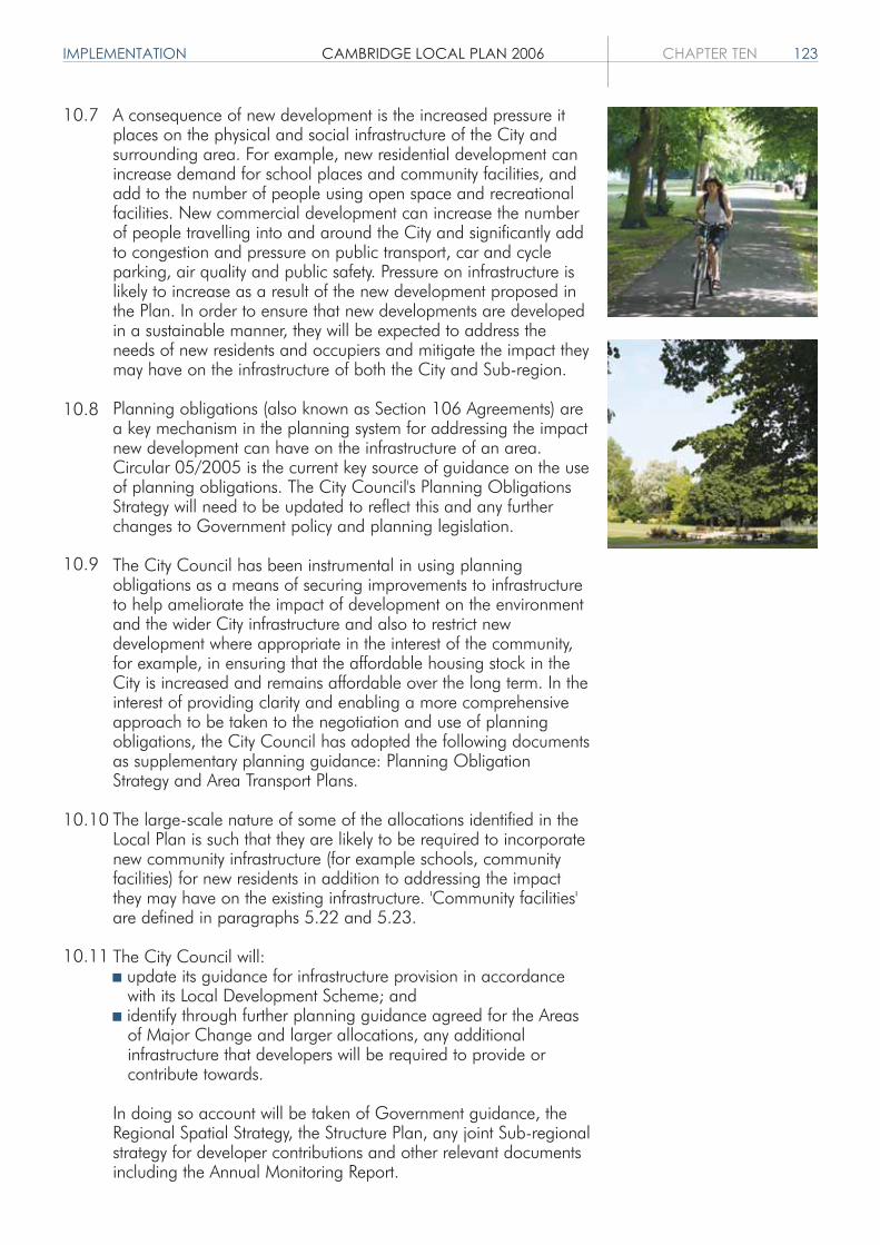
IMPLEMENTATION CAMBRIDGE LOCAL PLAN 2006 CHAPTER TEN 123
A consequence of new development is the increased pressure itplaces on the physical and social infrastructure of the City andsurrounding area. For example, new residential development canincrease demand for school places and community facilities, andadd to the number of people using open space and recreationalfacilities. New commercial development can increase the numberof people travelling into and around the City and significantly addto congestion and pressure on public transport, car and cycleparking, air quality and public safety. Pressure on infrastructure islikely to increase as a result of the new development proposed inthe Plan. In order to ensure that new developments are developedin a sustainable manner, they will be expected to address theneeds of new residents and occupiers and mitigate the impact theymay have on the infrastructure of both the City and Sub-region.
Planning obligations (also known as Section 106 Agreements) area key mechanism in the planning system for addressing the impactnew development can have on the infrastructure of an area.Circular 05/2005 is the current key source of guidance on the useof planning obligations. The City Council's Planning ObligationsStrategy will need to be updated to reflect this and any furtherchanges to Government policy and planning legislation.
The City Council has been instrumental in using planningobligations as a means of securing improvements to infrastructureto help ameliorate the impact of development on the environmentand the wider City infrastructure and also to restrict newdevelopment where appropriate in the interest of the community,for example, in ensuring that the affordable housing stock in theCity is increased and remains affordable over the long term. In theinterest of providing clarity and enabling a more comprehensiveapproach to be taken to the negotiation and use of planningobligations, the City Council has adopted the following documentsas supplementary planning guidance: Planning ObligationStrategy and Area Transport Plans.
The large-scale nature of some of the allocations identified in theLocal Plan is such that they are likely to be required to incorporatenew community infrastructure (for example schools, communityfacilities) for new residents in addition to addressing the impactthey may have on the existing infrastructure. 'Community facilities'are defined in paragraphs 5.22 and 5.23.
The City Council will: update its guidance for infrastructure provision in accordance
with its Local Development Scheme; and identify through further planning guidance agreed for the Areas
of Major Change and larger allocations, any additional infrastructure that developers will be required to provide or contribute towards.
In doing so account will be taken of Government guidance, theRegional Spatial Strategy, the Structure Plan, any joint Sub-regionalstrategy for developer contributions and other relevant documentsincluding the Annual Monitoring Report.
10.7
10.8
10.9
10.10
10.11

124 CHAPTER TEN CAMBRIDGE LOCAL PLAN 2006 IMPLEMENTATION
10/2 Monitoring and Review
Compliance with policies and development allocations in theLocal Plan will be continuously monitored throughout the Planperiod. If, through monitoring, it appears that Local Planpolicies and development allocations are not being met, thefollowing mechanisms will be triggered: review of land allocations; action to help bring forward sites for development, wherever
possible in partnership with landowners and developers; action to secure the timely provision of infrastructure; review of policies in the Local Plan; and review of the Local Plan in whole or in part.
In order to assess the effectiveness of the policies and proposalsin this Plan, it is important that continuous monitoring andreview of development changes taking place in the City isundertaken. Policy P1/4 and Chapter 11 of the Cambridgeshireand Peterborough Structure Plan set out the Plan, Monitor andManage approach and emphasise the need for regular reviewand monitoring of planning policies to determine theireffectiveness in providing for a more sustainable future and torespond to changing circumstances.
Monitoring and review will allow the Council and others toassess how effective the Plan policies and proposals are inbringing forward sustainable forms of development to satisfy therequirements of the Cambridgeshire Structure Plan andRegional Planning Guidance.
Monitoring and review will be conducted on an annual basis inaccordance with the monitoring needs of the Local Plan andwith those required by Government.
If as a result of the monitoring and review of Local Plan policiesand development allocations it appears to the City Council thatdevelopment is not coming forward in a sustainable or timelymanner, the City Council will be proactive in using its powers torespond to changing circumstances, for example taking actionto help bring sites forward for residential development inpartnership with landowners and developers through, forexample, the use of Compulsory Purchase Orders, review ofland allocations, review of policies in the Local Plan, and reviewof the Local Plan in whole or part.
10.12
10.13
10.14
10.15

APPENDICES CAMBRIDGE LOCAL PLAN 2006 125
APPENDICESA OPEN SPACE AND RECREATION STANDARDS
B CRITERIA TO ASSESS OPEN SPACE
C CAR PARKING STANDARDS
D CYCLE PARKING STANDARDS
E DESIGNATIONS SCHEDULE
F PROPOSALS SCHEDULE
G BIBLIOGRAPHY
H GLOSSARY


OPEN SPACE & RECREATION STANDARDS CAMBRIDGE LOCAL PLAN 2006 APPENDIX A 127
OPEN SPACE ANDRECREATION STANDARDS1. Introduction
Policy 3/8 requires that all residential developments should make provision for public open spaceand sports facilities in accordance with these standards.
Under PPG17 standards are to be set out for quantity, quality and accessibility of open spaces. Thestandards set out below are standards relating to quantity. The accompanying Open Space andRecreation Strategy provides further details on the justification for theses standards and includesguidance on accessibility and quality. It also includes further guidance as to when open space shouldbe provided on-site, and when it should be provided through commuted payments.
2. Definition of Public Open Space
The open space required under the standards is defined as any land laid out as a public garden orused for the purposes of public recreation. This means space which has unimpeded public access,and which is of a suitable size and nature for sport, active or passive recreation or children andteenagers' play. Private or shared amenity areas, for example in a development of flats, or bufferlandscaped areas are not included as public open space. This definition relates to both open spaceprovided within a development, and when considering the provision of existing open space.
Indoor sports facilities required under the standards must be accessible to the public, secured ifappropriate through a Community Use Agreement.
3. The Standards
Table 1 sets out the standards for different types of open space and recreation provision. They applyto all schemes for new residential developments and the requirement is based on the number ofpeople accruing from the development.
Table 1: The City Council's Open Space and Recreation Standards.
Type of Open Space
Outdoor Sports Facilities
Indoor Sports Provision
Provision for childrenand teenagers
Informal Open Space
Allotments
Definition
Playing pitches, courts and greens
Formal provision such as sportshalls and swimming pools
Equipped children's play areasand outdoor youth provision
Informal provision includingrecreation grounds, parks andnatural greenspaces
Allotments
Standard
1.2 hectares per 1,000 people
1 sports hall for 13,000 people1 swimming pool for 50,000people
0.3 hectares per 1,000 people
1.8 hectares per 1,000 people
0.4 hectares per 1,000 people

128 APPENDIX A CAMBRIDGE LOCAL PLAN 2006 OPEN SPACE & RECREATION STANDARDS
3.1 Outdoor Sports Facilities
This is an amalgamation of standards for different sports, based on team generation rates andcurrent provision. This comprises of: Grass pitches for football, cricket and rugby: 1.1 hectares per 1,000 people; Artificial Turf Pitches: 1 floodlit pitch per 25,000 people; Tennis/Multi Use Games Areas (MUGAs) of 3 tennis courts size per 3,000 people; and 1 Bowling Green per 11,000 people.
Grass PitchesThis is based on existing team generation rates with an allowance for increased demand. Itcomprises 0.88 hectares per 1,000 for football, 0.14 hectares per 1,000 for cricket and 0.1hectares per 1,000 for rugby.
Artificial Turf Pitches (ATPs)This is based on the existing team generation rates for hockey, which is almost entirely played onATPs, with an allowance for increased demand. The pitches will also meet other needs includingfootball training. They must be floodlit.
Tennis courts/MUGAsThis is based on the appropriate catchment area to support such a facility and is comparable to theexisting provision of both public and private tennis courts.
Bowling GreensThis is based on existing provision in the City.
Most housing development sites within the existing built up area of Cambridge are too small to beable to make much contribution to the provision of outdoor sports facilities on-site. Accordingly, it islikely that provision will be in the form of commuted payments.
3.2 Indoor Sports
This relates to formal sports provision. The standard is based on existing and committed provision ofswimming pools and sports halls. These will meet demand but there is little spare capacity. All newdevelopments should therefore contribute through commuted payments based on the provision ofnew sports halls and a swimming pool.
3.3 Provision for Children and Teenagers
This is a combination of equipped children's play areas, and outdoor youth provision such askickabout areas, basketball 'half courts', skateboard parks and youth shelters.
The amount of provision on-site should depend on: the size and character of the proposed development; townscape considerations; its location in relation to adjacent housing and existing open space; and opportunities for creating or improving provision for children and teenagers nearby.
3.4 Informal Open Space
This includes unequipped areas for casual play and informal activities adjacent to provision forchildren and teenagers, some of which will be required to provide a buffer zone for equipped areas(as above). It also includes amenity greenspaces within housing areas, as well as natural

OPEN SPACE & RECREATION STANDARDS CAMBRIDGE LOCAL PLAN 2006 APPENDIX A 129
greenspaces and nature reserves.The amount of provision on site should depend on: the size and character of the proposed development; the character of the surrounding area; and its location in relation to existing open space.
3.5 Allotments
This reflects existing provision. Provision for new allotments should be made in the urban extensions.
4. When the Standards Should be Applied
The standards are applicable to all new residential units created as a result of development regardless ofwhether they result from new-build or conversions. Where the proposal relates to the conversion ofexisting residential units to create additional units or the redevelopment of an existing residential site theopen space standards will be applied to the number of additional units created.
Certain types of housing will not always need to meet the full standard, as shown in table 2.
Table 2: Application of the Standards.
# Provision for children and teenagers will not be sought for those parts of developments consisting of one bedroom units.
+ Retirement housing is any accommodation in Class C3 where there is an age restriction of over 55. The standards do notapply to nursing homes within Class C2.
* Full provision will not be sought if the accommodation is directly linked to a College by a Section 106 Agreement and it canbe shown that adequate provision of outdoor or indoor sports facilities is made by that College. Although such provision willnot meet the definition of public space, it is accepted that if adequate provision is made by the College, students will beunlikely to use public sports facilities.
** Full provision will not be sought if the development is on a College campus and it can be shown that adequate appropriateopen space is provided by the College such that students are unlikely to make significant use of other informal open space.
The open space requirement for other specialist housing will be considered on its merits.
Outdoorsports facilities
Provision forchildren andteenagers
Informalopen space
Indoor sportsprovision
Allotments
Private Residential/Housing Association
Full provision
Full provision #
Full provision
Full provision
Urban Extensions only
Retirement housing +
Full provision
No provision
Full provision
Full provision
Urban Extensions only
Non-familystudent housing
Full provision *
No provision
Full provision **
Full provision *
No provision
Family studenthousing
Full provision *
Full provision**
Full provision**
Full provision *
No provision

130 APPENDIX A CAMBRIDGE LOCAL PLAN 2006 OPEN SPACE & RECREATION STANDARDS
5. How the Standards Should be Applied
The amount of land required to meet the standard is calculated for each type of open space orsports provision. This is done by calculating the number of new residents accruing from thedevelopment using the number of bedrooms in each unit as a guide. The number of people is takento be the same as the number of bedrooms, except for one bedroom units which will be assumed tohave 1.5 people.
The only exception to this will be for student housing, where the number of students to beaccommodated will be used.
Having calculated the amount of land required, consideration will then be given as to whether thisshould be provided on-site or through commuted payments for each type of open space or sportsprovision.
6. Commuted Payments
Any shortfall in provision on-site should be met by commuted payments. These are based on the costof providing and, where appropriate, maintaining that type of open space or sports facility. These willbe spent on improving that type of provision or contributing towards new provision. Commutedpayments will also be sought for the maintenance of any public open space provided on-site.

CRITERIA TO ASSESS OPEN SPACE CAMBRIDGE LOCAL PLAN 2006 APPENDIX B 131
CRITERIA TO ASSESS OPEN SPACE1. Introduction
The criteria have been developed to determine if open spaces are important for environmentalreasons, recreational reasons or both.
There are separate sets of criteria relating to the environmental and recreational importance.Sites are judged against both of these to determine whether they should be protected forenvironmental importance, recreational importance, or both. In order to be considered worthyof protection they need to fulfil at least one of the criteria. The questions under each criterionin sections four and five are used to assess which sites meet that criterion.
2. Criteria for Environmental Importance
a) Does the site make a major contribution to the setting, character, structure and the environmental quality of the City?
b) Does the site make a major contribution to the character and environmental quality of the local area?
c) Does the site contribute to the wildlife value and biodiversity of the City?
If yes to any of these, the site is worthy of protection for environmental reasons.
3. Criteria for recreational importance
d) Does the site make a major contribution to the recreational resources of the City?e) Does the site make a major contribution to the recreational resources of the local area?
If yes to either of these, the site is worthy of protection for recreational reasons.
4. Questions used to assess whether open space meets the criteria forenvironmental importance
a) Does the site make a major contribution to the setting, character, structure and the environmental quality of the City?i) Does it make a major contribution to the setting of Cambridge?ii) Does it have positive landscape features and/or a sense of place sufficient for it to make
a major contribution to the character of the City?iii) Is the site an important green break in the urban framework?iv) Does it have significant historical, cultural or known Archeological interest?
b) Does the site make a major contribution to the character and environmental quality of the local area? i) Does it have positive features such as streams, trees, hedgerows or meadowlands which
give it a sense of place sufficient to make a major contribution to the character of the local area?
ii) Is it an important green break in the framework of the local area?iii) Does it form part of a network of open spaces in the local area?iv) Is it enjoyed visually on a daily basis from public places (e.g. footpaths, vantage points)?v) Does it have local historical or cultural interest?
1.1
1.2

132 APPENDIX B CAMBRIDGE LOCAL PLAN 2006 CRITERIA TO ASSESS OPEN SPACE
c) Does the site contribute to the wildlife value and biodiversity of the City?i) Does it have any nature conservation designation?ii) Is it adjacent to or an important link to sites with nature conservation designation?iii) Does it contain important habitats or species sufficient to make it worthy of
consideration for any nature conservation designation?iv) Is it an important wildlife oasis in an area with limited wildlife value?
5. Questions used to assess whether open space meets the criteria forrecreational importance
Recreational resources include land for formal pitch sports, play areas, kickabout areas,informal open spaces used for walking, cycling, picnic, play, kite flying, nature appreciationetc. and allotments.
d) Does the site make a major contribution to the recreational resources of the City as a whole1?i) Is it of a size, quality and accessibility such that people would travel to use it for
recreational purposes, no matter where they live, work or study in the City? ii) Is it an important part of the network of significant recreational open spaces?iii) Is it part of the sports provision which help to meet demand from people throughout
the City no matter where they live, work or study?
e) Does the site make a major contribution to the recreational resources of the local area2?i) Is it of a size and accessibility such that people who live, work or study in the local area
do or could use it for recreational purposes?ii) Is it an important part of the network and hierarchy of recreational facilities in the local
area?iii) Is it a significant linkage between recreational areas?
1 Recreational resources of the City include playing fields used by Colleges or sports clubs, school playing fieldswhich are also used by sports clubs and commons and other recreation grounds which people would go out oftheir way to visit.2 Recreational resources of the local area include playing fields which are well related to their users. This couldinclude playing fields which are part of a College site or school playing fields.
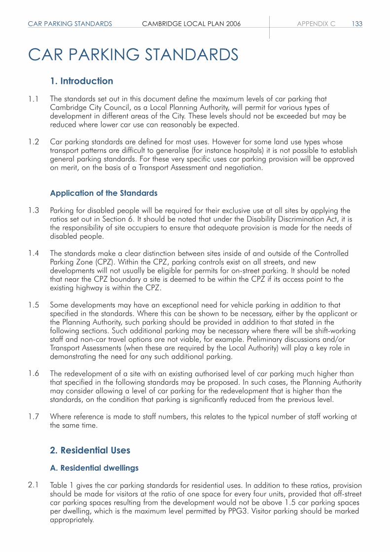
CAR PARKING STANDARDS CAMBRIDGE LOCAL PLAN 2006 APPENDIX C 133
CAR PARKING STANDARDS1. Introduction
The standards set out in this document define the maximum levels of car parking thatCambridge City Council, as a Local Planning Authority, will permit for various types ofdevelopment in different areas of the City. These levels should not be exceeded but may bereduced where lower car use can reasonably be expected.
Car parking standards are defined for most uses. However for some land use types whosetransport patterns are difficult to generalise (for instance hospitals) it is not possible to establishgeneral parking standards. For these very specific uses car parking provision will be approvedon merit, on the basis of a Transport Assessment and negotiation.
Application of the Standards
Parking for disabled people will be required for their exclusive use at all sites by applying theratios set out in Section 6. It should be noted that under the Disability Discrimination Act, it isthe responsibility of site occupiers to ensure that adequate provision is made for the needs ofdisabled people.
The standards make a clear distinction between sites inside of and outside of the ControlledParking Zone (CPZ). Within the CPZ, parking controls exist on all streets, and newdevelopments will not usually be eligible for permits for on-street parking. It should be notedthat near the CPZ boundary a site is deemed to be within the CPZ if its access point to theexisting highway is within the CPZ.
Some developments may have an exceptional need for vehicle parking in addition to thatspecified in the standards. Where this can be shown to be necessary, either by the applicant orthe Planning Authority, such parking should be provided in addition to that stated in thefollowing sections. Such additional parking may be necessary where there will be shift-workingstaff and non-car travel options are not viable, for example. Preliminary discussions and/orTransport Assessments (when these are required by the Local Authority) will play a key role indemonstrating the need for any such additional parking.
The redevelopment of a site with an existing authorised level of car parking much higher thanthat specified in the following standards may be proposed. In such cases, the Planning Authoritymay consider allowing a level of car parking for the redevelopment that is higher than thestandards, on the condition that parking is significantly reduced from the previous level.
Where reference is made to staff numbers, this relates to the typical number of staff working atthe same time.
2. Residential Uses
A. Residential dwellings
Table 1 gives the car parking standards for residential uses. In addition to these ratios, provisionshould be made for visitors at the ratio of one space for every four units, provided that off-streetcar parking spaces resulting from the development would not be above 1.5 car parking spacesper dwelling, which is the maximum level permitted by PPG3. Visitor parking should be markedappropriately.
1.1
1.2
1.3
1.4
1.5
1.6
1.7
2.1
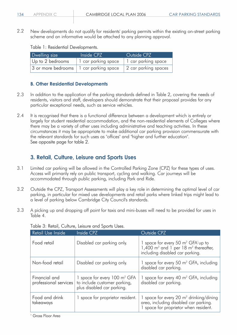
134 APPENDIX C CAMBRIDGE LOCAL PLAN 2006 CAR PARKING STANDARDS
2.3
2.2
2.4
3.1
3.2
3.3
New developments do not qualify for residents' parking permits within the existing on-street parkingscheme and an informative would be attached to any planning approval.
Table 1: Residential Developments.
B. Other Residential Developments
In addition to the application of the parking standards defined in Table 2, covering the needs ofresidents, visitors and staff, developers should demonstrate that their proposal provides for anyparticular exceptional needs, such as service vehicles.
It is recognised that there is a functional difference between a development which is entirely orlargely for student residential accommodation, and the non-residential elements of Colleges wherethere may be a variety of other uses including administrative and teaching activities. In thesecircumstances it may be appropriate to make additional car parking provision commensurate withthe relevant standards for such uses as "offices" and "higher and further education".See opposite page for table 2.
3. Retail, Culture, Leisure and Sports Uses
Limited car parking will be allowed in the Controlled Parking Zone (CPZ) for these types of uses.Access will primarily rely on public transport, cycling and walking. Car journeys will beaccommodated through public parking, including Park and Ride.
Outside the CPZ, Transport Assessments will play a key role in determining the optimal level of carparking, in particular for mixed use developments and retail parks where linked trips might lead toa level of parking below Cambridge City Council's standards.
A picking up and dropping off point for taxis and mini-buses will need to be provided for uses inTable 4.
Table 3: Retail, Culture, Leisure and Sports Uses.
1 Gross Floor Area
Dwelling sizeUp to 2 bedrooms3 or more bedrooms
Inside CPZ1 car parking space1 car parking space
Outside CPZ1 car parking space2 car parking spaces
Retail Use Inside
Food retail
Non-food retail
Financial andprofessional services
Food and drinktakeaways
Inside CPZ
Disabled car parking only.
Disabled car parking only.
1 space for every 100 m2 GFAto include customer parking,plus disabled car parking.
1 space for proprietor resident.
Outside CPZ
1 space for every 50 m2 GFA1up to1,400 m2 and 1 per 18 m2 thereafter,including disabled car parking.
1 space for every 50 m2 GFA, includingdisabled car parking.
1 space for every 40 m2 GFA, includingdisabled car parking.
1 space for every 20 m2 drinking/diningarea, including disabled car parking.1 space for proprietor when resident.

CAR PARKING STANDARDS CAMBRIDGE LOCAL PLAN 2006 APPENDIX C 135
Inside CPZ
1 space for every 4 bedroomsand 1 space per resident staff.
1 space for every 10 residents,1 space for every 2 membersof staff.
1 space for every 6 units, 1space for every 2 membersof staff.
1 space for every 10 bedspaces. A pickup and drop-offarea could also be included ifappropriate to the particularproposed development.
1 space for every residentwarden/staff.
1 space for every 5 bedspaces.1 space for everyresident warden/staff.
1 space for every 3non-resident staff plus 1 spaceper resident warden/staff.
On merit
Outside CPZ
2 spaces for every 3 bedroomsand 1 space per resident staff.
1 space for every 8 residents,1 space for every 2 membersof staff.
1 space for every 4 units, 1space for every 2 membersof staff.
1 space for every 10 bedspaces. A pickup and drop-offarea could also be included ifappropriate to the particularproposed development.
1 space for every residentwarden/staff.
1 space for every 3 bedspaces.1 space for everyresident warden/staff.
On merit
On merit
Type of Development
Guest houses and hotels
Nursing homes
Retirement homes/sheltered houses
Student residentialaccommodation whereproctorial control or alternativecontrol on car parking exists
Student residentialaccommodation whereproctorial control does notexist or where control existsbut the development willhouse conference delegates
Residential schools, collegeor training centre
Hospitals
Off-street coach parking to be conveniently located in relation todevelopments of 40 or more bedrooms. Where there are roomsspecifically designed for people with disabilities, disabled parking ofat least 1 space for each room so designed should be provided.
Provision must be made for ambulance parking.
Provision must be made for ambulance parking. A covered,enclosed area with electricity sockets needs to be provided forelectric buggies.
Where there are rooms specifically designed for people withdisabilities, disabled parking of at least 1 space for each roomso designed should be provided.
Where there are rooms specifically designed for people withdisabilities, disabled parking of at least 1 space for each roomso designed should be provided. Controls will be necessary tolimit use of car parking outside conference times.
Where there are rooms specifically designed for people withdisabilities, disabled parking of at least 1 space for each roomso designed should be provided.
Table 2: Other Residential Developments.
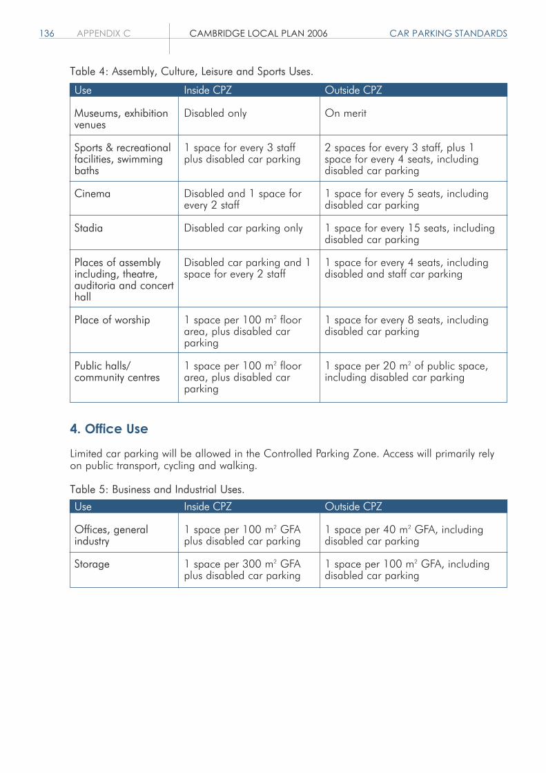
136 APPENDIX C CAMBRIDGE LOCAL PLAN 2006 CAR PARKING STANDARDS
Table 4: Assembly, Culture, Leisure and Sports Uses.
4. Office Use
Limited car parking will be allowed in the Controlled Parking Zone. Access will primarily relyon public transport, cycling and walking.
Table 5: Business and Industrial Uses.
Use
Museums, exhibitionvenues
Sports & recreationalfacilities, swimmingbaths
Cinema
Stadia
Places of assemblyincluding, theatre,auditoria and concerthall
Place of worship
Public halls/community centres
Inside CPZ
Disabled only
1 space for every 3 staffplus disabled car parking
Disabled and 1 space forevery 2 staff
Disabled car parking only
Disabled car parking and 1space for every 2 staff
1 space per 100 m2 floorarea, plus disabled carparking
1 space per 100 m2 floorarea, plus disabled carparking
Outside CPZ
On merit
2 spaces for every 3 staff, plus 1space for every 4 seats, includingdisabled car parking
1 space for every 5 seats, includingdisabled car parking
1 space for every 15 seats, includingdisabled car parking
1 space for every 4 seats, includingdisabled and staff car parking
1 space for every 8 seats, includingdisabled car parking
1 space per 20 m2 of public space,including disabled car parking
Use
Offices, generalindustry
Storage
Inside CPZ
1 space per 100 m2 GFAplus disabled car parking
1 space per 300 m2 GFAplus disabled car parking
Outside CPZ
1 space per 40 m2 GFA, includingdisabled car parking
1 space per 100 m2 GFA, includingdisabled car parking

5. Non-residential Institutions
Table 6: Non-Residential Institutions.
6. Provision for People with Disabilities
Generally, at least 5% of the total number of car parking spaces, as given by the standards foroutside the CPZ, should be reserved for disabled people, rounded up to the nearest wholespace. Where parking provision is below the standards for outside the CPZ (including on siteswithin the CPZ) the required proportion of spaces reserved for disabled people will thereforebe higher than 5%.
Higher ratios than the 5% given above may be required in some cases by the PlanningAuthority, for example at medical facilities, residential care homes, community facilities andany other uses where a higher proportion of disabled users/visitors will be expected. It shouldbe noted that provision at the above levels or any required by the Planning Authority does notguarantee that the requirements of the Disability Discrimination Act will be met, which is theresponsibility of the building occupier or service provider.
Spaces for disabled people should be located adjacent to entrances, be convenient to use andhave dimensions that conform to Part M of the Building Regulations. If it is impossible toaccommodate car parking spaces within the site, disabled car parking spaces should not belocated at a distance more than 100 metres from the site.
Disabled car parking spaces should be marked either 'disabled' or with a wheelchair marking.
CAR PARKING STANDARDS CAMBRIDGE LOCAL PLAN 2006 APPENDIX C 137
Use
Clinics and surgeries
Non-residentialschools
Non-residentialhigher andfurther education
Crèches
Inside CPZ
1 space for every 2 professionalmembers of staff plus 1 spaceper consulting room
1 space for every 3 staff
1 space for every 4 staff
1 space for every 3 staff
Outside CPZ
1 space for every professionalmember of staff plus 2 spaces perconsulting room
2 spaces for every 3 staff
2 spaces for every 3 staff
2 spaces for every 3 staff
6.1
6.2
6.3
6.4

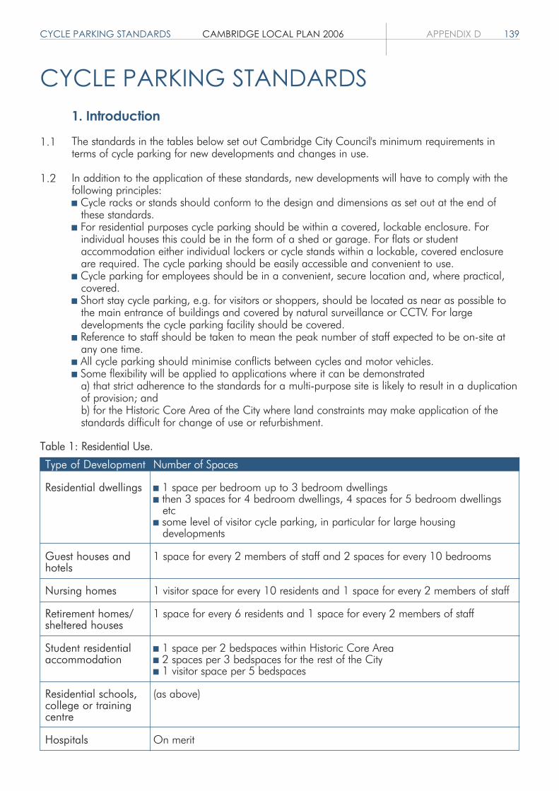
CYCLE PARKING STANDARDS CAMBRIDGE LOCAL PLAN 2006 APPENDIX D 139
CYCLE PARKING STANDARDS1. Introduction
The standards in the tables below set out Cambridge City Council's minimum requirements interms of cycle parking for new developments and changes in use.
In addition to the application of these standards, new developments will have to comply with thefollowing principles: Cycle racks or stands should conform to the design and dimensions as set out at the end of
these standards. For residential purposes cycle parking should be within a covered, lockable enclosure. For
individual houses this could be in the form of a shed or garage. For flats or student accommodation either individual lockers or cycle stands within a lockable, covered enclosure are required. The cycle parking should be easily accessible and convenient to use. Cycle parking for employees should be in a convenient, secure location and, where practical,
covered. Short stay cycle parking, e.g. for visitors or shoppers, should be located as near as possible to
the main entrance of buildings and covered by natural surveillance or CCTV. For large developments the cycle parking facility should be covered. Reference to staff should be taken to mean the peak number of staff expected to be on-site at
any one time. All cycle parking should minimise conflicts between cycles and motor vehicles. Some flexibility will be applied to applications where it can be demonstrated
a) that strict adherence to the standards for a multi-purpose site is likely to result in a duplicationof provision; andb) for the Historic Core Area of the City where land constraints may make application of the standards difficult for change of use or refurbishment.
1.1
1.2
Type of Development
Residential dwellings
Guest houses andhotels
Nursing homes
Retirement homes/sheltered houses
Student residentialaccommodation
Residential schools,college or trainingcentre
Hospitals
Number of Spaces
1 space per bedroom up to 3 bedroom dwellings then 3 spaces for 4 bedroom dwellings, 4 spaces for 5 bedroom dwellings
etc some level of visitor cycle parking, in particular for large housing
developments
1 space for every 2 members of staff and 2 spaces for every 10 bedrooms
1 visitor space for every 10 residents and 1 space for every 2 members of staff
1 space for every 6 residents and 1 space for every 2 members of staff
1 space per 2 bedspaces within Historic Core Area 2 spaces per 3 bedspaces for the rest of the City 1 visitor space per 5 bedspaces
(as above)
On merit
Table 1: Residential Use.
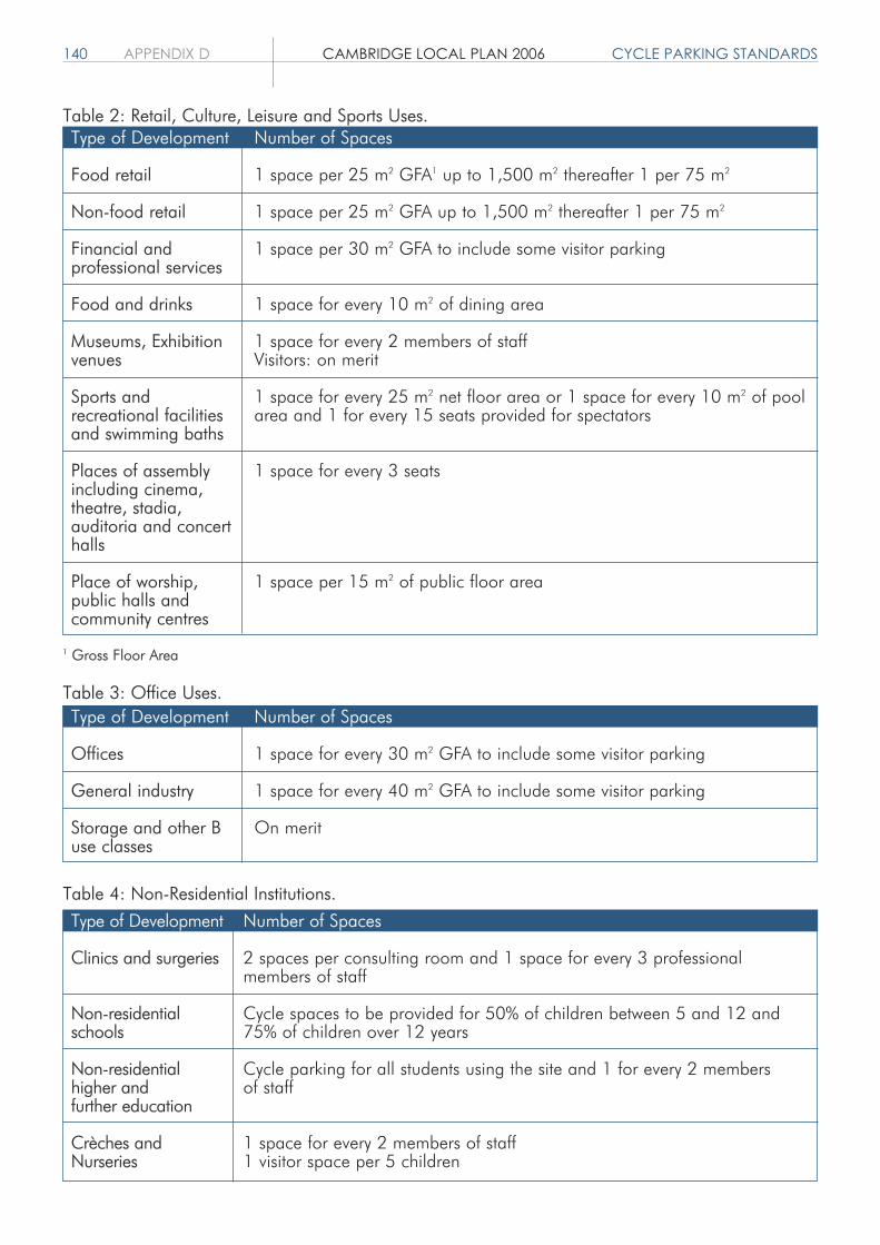
140 APPENDIX D CAMBRIDGE LOCAL PLAN 2006 CYCLE PARKING STANDARDS
Table 2: Retail, Culture, Leisure and Sports Uses.
1 Gross Floor Area
Table 3: Office Uses.
Type of Development
Food retail
Non-food retail
Financial andprofessional services
Food and drinks
Museums, Exhibitionvenues
Sports andrecreational facilitiesand swimming baths
Places of assemblyincluding cinema,theatre, stadia,auditoria and concerthalls
Place of worship,public halls andcommunity centres
Number of Spaces
1 space per 25 m2 GFA1 up to 1,500 m2 thereafter 1 per 75 m2
1 space per 25 m2 GFA up to 1,500 m2 thereafter 1 per 75 m2
1 space per 30 m2 GFA to include some visitor parking
1 space for every 10 m2 of dining area
1 space for every 2 members of staffVisitors: on merit
1 space for every 25 m2 net floor area or 1 space for every 10 m2 of poolarea and 1 for every 15 seats provided for spectators
1 space for every 3 seats
1 space per 15 m2 of public floor area
Type of Development
Offices
General industry
Storage and other Buse classes
Number of Spaces
1 space for every 30 m2 GFA to include some visitor parking
1 space for every 40 m2 GFA to include some visitor parking
On merit
Type of Development
Clinics and surgeries
Non-residentialschools
Non-residentialhigher andfurther education
Crèches andNurseries
Number of Spaces
2 spaces per consulting room and 1 space for every 3 professionalmembers of staff
Cycle spaces to be provided for 50% of children between 5 and 12 and75% of children over 12 years
Cycle parking for all students using the site and 1 for every 2 membersof staff
1 space for every 2 members of staff1 visitor space per 5 children
Table 4: Non-Residential Institutions.
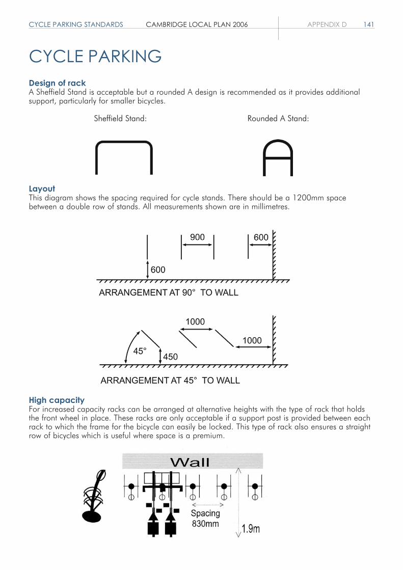
CYCLE PARKING STANDARDS CAMBRIDGE LOCAL PLAN 2006 APPENDIX D 141
CYCLE PARKINGDesign of rackA Sheffield Stand is acceptable but a rounded A design is recommended as it provides additionalsupport, particularly for smaller bicycles.
Sheffield Stand: Rounded A Stand:
LayoutThis diagram shows the spacing required for cycle stands. There should be a 1200mm spacebetween a double row of stands. All measurements shown are in millimetres.
High capacityFor increased capacity racks can be arranged at alternative heights with the type of rack that holdsthe front wheel in place. These racks are only acceptable if a support post is provided between eachrack to which the frame for the bicycle can easily be locked. This type of rack also ensures a straightrow of bicycles which is useful where space is a premium.


DESIGNATIONS SCHEDULE CAMBRIDGE LOCAL PLAN 2006 APPENDIX E 143
DESIGNATIONS SCHEDULEConservation Areas (Policy 4/11)1 Central2 West3 Chesterton4 Chesterton Water Lane5 Trumpington6 Conduit Head Road7 Storey's Way8 Newnham Croft9 Southacre10 Brooklands
SSSIs (Policy 4/5)1 Cherry Hinton Pit2 Travellers' Rest Pit
Local Nature Reserves (Policy 4/6)1 Paradise2 Barnwell East3 Barnwell West4 Limekiln Close and West Pit5 Bramblefields
County Wildlife Sites (Policy 4/6)Hedgerows east of M11Coton path hedgerowBarton Road poolSkaters' Meadow groupParadise LNRSheep's GreenCoe FenTrumpington dismantled railwayCambridge Botanic GardensWorts' Causeway RSV and hedgerowLime Kiln Hill ReservoirsGrassland adjacent to West pitLime Kiln Close LNRThe Spinney (at Hayster Open Space)River Cam site which includes: Meadows and drains Reedbed opposite Paradise Mill Pool Queen's Road/King's College ditch Meadow opposite King's college Midsummer Common Elizabeth Way bridge pollard willows Logan's Way open ground Stourbridge Common

144 APPENDIX E CAMBRIDGE LOCAL PLAN 2006 DESIGNATIONS SCHEDULE
City Wildlife Sites (Policy 4/6)Scrub east of M11 vergeBird sanctuary, Conduit HeadOld Mill PlantationGrantchester Road plantationsEight Acre Wood and Seven Acre WoodBin BrookAdams Road sanctuarySt Giles cemeteryTrumpington Road woodlandNewnham College conservation area (phase 1 survey only)Little St Mary's churchyardTrinity MeadowDrain at Garret Hostel LaneHobson's Brook/Vicar's Brook (master site)Long Road plantationTriangle north of Long RoadEmpty Common – scrubBentley Road paddocksEmmanuel College gardens (phase 1 survey only)Kings Hedges triangle/scrubRed Cross Lane drainHedgerow west of Babraham RoadMill Road cemeterySt Andrew's ChestertonNetherhall Farm meadowCherry Hinton BrookTerritorial Army pitBlue Circle, Norman cement (phase 1 survey only)Coldham's CommonColdham's BrookBarnwell Road west – scrubBarnwell Road LNR (Uphall Rd)Barnwell pitBarnwell Junction disused railwayBarnwell Junction pasturesDitton MeadowsMilton Road hedgeLimekiln Road vergeCherry Hinton Hall bird sanctuaryCherry Hinton Hall brookLove Lane pollardsRailway between pits (phase 1 survey only)Blue Circle Norman cement pit east (phase 1 survey only)Blue Circle chalk pit (phase 1 survey only)Blue Circle old landfill (phase 1 survey only)Blue Circle oldest landfill (phase 1 survey only)Cherry Hinton churchyardColdham's Lane hedgerowTeversham Drift hedgerow

DESIGNATIONS SCHEDULE CAMBRIDGE LOCAL PLAN 2006 APPENDIX E 145
District and Local Centres (Policy 6/7)1 Adkins Corner2 Akeman Street3 Arbury Court4 Arbury Road/Milton Road5 Barnwell Road6 Campkin Road7 Cherry Hinton High Street8 Cherry Hinton Road East9 Cherry Hinton Road West10 Chesterton High Street11 Ditton Lane12 Fairfax Road13 Grantchester Street14 Green End Road15 Hills Road16 Histon Road17 Kings Hedges Road18 Mitcham's Corner (District Centre)19 Mill Road East (District Centre)20 Mill Road West (District Centre)21 Newnham Road22 Norfolk Street23 Trumpington24 Victoria Road25 Wulfstan Way
Protected Industrial Sites (Policy 7/3)1 Kings Hedges Road – Kirkwood Road/Kilmaine Close2 Ditton Walk (North) – Beadle Industrial Estate3 Mercers Row Industrial Estate4 Cherry Hinton Road – Clifton Court and Clifton Road5 College Business Park, Coldham's Lane6 Jedburgh Court, Jedburgh Close7 Ronald Rolph Court, Wadloes Road8 Barnwell Business Park and Barnwell Drive9 Coldham's Lane Business Park, Coldham's Lane10 Purbeck Road


PROPOSALS SCHEDULE CAMBRIDGE LOCAL PLAN 2006 APPENDIX F 147
PRO
POSA
LS S
CHE
DUL
E
Site
Num
ber
3.01
5.01
5.02
5.03
5.04
5.05
5.06
5.07
5.08
5.09
5.10
5.11
Area
(ha)
0.98
3.04
2.80
2.44
2.41
1.71
1.67
1.47
1.26
1.23
1.19
0.95
Addr
ess
Fen
Road
Land
off
Fitz
will
iam
Roa
dan
d C
lare
ndon
Roa
d
The
Padd
ocks
Tra
ding
Est
ate,
Che
rry
Hin
ton
Road
Cro
mw
ell R
oad
379
to 3
81 M
ilton
Roa
d
Cam
brid
ge C
ity F
ootb
all G
roun
d,M
ilton
Roa
d
Briti
sh T
elec
om,
Long
Roa
d
Will
owcr
oft,
His
ton
Road
Terr
itoria
l Arm
y, C
herr
y H
into
n Ro
ad
Trav
is P
erki
ns,
Dev
onsh
ire R
oad
The
Nuf
field
Hos
pita
l, Tr
umpi
ngto
n Ro
ad
Car
avan
Par
k, F
en R
oad
Prop
osed
Use
Off-
river
moo
rings
Hou
sing
Hou
sing
Hou
sing
Hou
sing
Hou
sing
Hou
sing
Hou
sing
Hou
sing
Hou
sing
Hou
sing
Hou
sing
Polic
y
3/9
5/1
5/1
5/1
5/1
5/1
5/1
5/1
5/1
5/1
5/1
5/1
Com
men
ts
The
natu
re a
nd s
cale
of
deve
lopm
ent t
o be
con
sist
ent w
ithth
e de
sign
atio
n as
Gre
en B
elt.
See
Mitc
ham
's C
orne
r St
rate
gic
Plan
ning
and
Dev
elop
men
t Brie
f20
03.
Publ
ic O
pen
Spac
e sh
ould
be in
clud
ed o
n si
te.
Dev
elop
men
tde
pend
ent u
pon
relo
catio
n of
foot
ball
club

148 APPENDIX F CAMBRIDGE LOCAL PLAN 2006 PROPOSALS SCHEDULESi
te N
o
5.12
5.13
5.14
5.15
5.16
5.17
5.18
5.19
5.20
6.01
7.01
7.02
7.03
7.04
Area
(ha)
0.95
0.89
0.80
0.77
0.77
0.71
0.60
0.43
0.44
0.36
2.01
1.17
0.95
0.71
Addr
ess
Park
side
Polic
e an
dFi
re S
tatio
ns, P
arks
ide
Milt
on In
fant
and
Juni
or S
choo
l,Milt
on R
oad
Ridg
eons
, Cav
endi
sh R
oad
Hen
ry G
iles
Hou
se,
Che
sterto
n Ro
ad
147
Hill
s Ro
ad
295
Hist
on R
oad
Sand
y La
ne
135
Long
Roa
d
Net
herh
all S
choo
l Upp
er S
ite
Brad
wel
l's C
ourt
New
Stre
et/N
ewm
arke
t Roa
d
Betje
man
Hou
se, H
ills
Road
Col
dham
's La
ne/N
ewm
arke
tRo
ad
Mitc
ham
's C
orne
r Site
s
Prop
osed
Use
Hou
sing
and
com
mun
ity fa
cilit
ies
Hou
sing
and
com
mun
ity fa
cilit
ies
Hou
sing
Hou
sing
Hou
sing
Hou
sing
Hou
sing
Hou
sing
Scho
ol E
xpan
sion
Mixe
d us
es in
clud
ing
A1 re
tail,
A2,
A3
and
with
priv
ate
or s
tude
nt re
siden
tial a
bove
Empl
oym
ent,
B1, H
ousin
g, S
tude
nt h
oste
ls
Mixe
d us
e B1
(a),
B1(b
), A1
reta
il, A
3 an
dho
usin
g
Mixe
d us
es in
clud
ing
hous
ing
and
empl
oym
ent B
1(a)
(not
exc
eedi
ng e
xistin
gB1
(a) f
loor
spac
e), h
otel
,stu
dent
hos
tel a
ndA1
non
-food
reta
il (n
ot e
xcee
ding
50%
of
the
site
area
)
Mixe
d us
es in
clud
ing
empl
oym
ent B
1(a)
,lo
cal A
1, A
2, A
3 an
d ho
usin
g
Polic
y
5/1,
5/1
2
5/1,
5/1
2
5/1
5/1
5/1
5/1
5/1
5/1
5/12
6/5,
5/1
,7/
7, 7
/10
5/1,
7/1
,7/
2, 7
/9
5/1,
7/1,
7/2
5/1,
7/1
,7/
2, 7
/10
5/1,
7/1,
7/2
Com
men
ts
See
Mitc
ham
's C
orne
r Stra
tegi
cPl
anni
ng a
nd D
evel
opm
ent
Brie
f 200
3
See
Mitc
ham
's C
orne
r Stra
tegi
cPl
anni
ng a
nd D
evel
opm
ent
Brie
f 200
3
See
Brad
wel
l's C
ourt
Plan
ning
Brie
f
See
Mitc
ham
's C
orne
r Stra
tegi
cPl
anni
ng a
nd D
evel
opm
ent
Brie
f 200
3

PROPOSALS SCHEDULE CAMBRIDGE LOCAL PLAN 2006 APPENDIX F 149Si
te N
o
7.05
7.06
7.07
7.08
7.09
7.10
7.11
Area
(ha)
0.35
66.9
0
2.94
1.97
1.21
0.82
1.57
Addr
ess
Col
dham
's Ro
ad
Wes
t Cam
brid
ge S
ite,
Sout
h of
Mad
ingl
ey R
oad
Leck
ham
pton
Hou
seG
roun
ds
New
Mus
eum
s Si
te,
Dow
ning
Stre
et/
Pem
brok
e St
reet
Gra
nge
Farm
off
Wilb
erfo
rce
Road
Mill
Lan
e/O
ld P
ress
Site
Brun
swic
k Si
te
Prop
osed
Use
Empl
oym
ent.
B1(c
), B2
Hig
her E
duca
tion.
D1
Uni
vers
ity F
acul
ty,B1
(b),
sui g
ener
is re
sear
ch in
stitu
tes,
sta
ffan
d stu
dent
hou
sing,
spo
rts a
nd s
hare
dfa
cilit
ies
Stud
ent h
oste
l or a
fford
able
/key
wor
ker
hous
ing
for t
he C
olle
ges.
Rede
velo
pmen
t/re
furb
ishm
ent f
orpr
edom
inan
tly U
nive
rsity
use
s, w
ith s
ome
mixe
d us
e to
enh
ance
the
attra
ctiv
enes
s of
the
publ
ic re
alm
Stud
ent h
oste
l or a
fford
able
/key
wor
ker
hous
ing
for t
he C
olle
ges
Rede
velo
pmen
t/re
furb
ishm
ent f
orpr
edom
inan
tly U
nive
rsity
use
s, w
ith s
ome
mixe
d us
e to
enh
ance
the
attra
ctiv
enes
s of
the
publ
ic re
alm
Mixe
d us
e ho
usin
g de
velo
pmen
t and
com
mun
ity fa
cilit
ies.
Cou
ld in
clud
e a
stude
nt h
oste
l for
Ang
lia R
uski
n U
nive
rsity
on p
art o
f the
site
in li
eu o
f affo
rdab
leho
usin
g
Polic
y
7/1,
7/2
5/1,
7/1
,7/
2, 7
/4,
7/6
7/7
7/5
7/7
7/5
7/9
Com
men
ts
In a
ccor
danc
e w
ith a
gree
dM
aste
rpla
n
The
capa
city
and
app
roac
h to
deve
lopm
ent w
ill b
e co
nstra
ined
by
the
need
to b
e se
nsiti
ve to
the
land
scap
e as
pect
s, in
clud
ing
the
trees
, the
bui
ldin
gs a
t the
nor
ther
nen
d an
d th
e na
ture
con
serv
atio
nin
tere
st an
d tre
e pl
antin
g of
the
site;
dev
elop
men
t brie
f nee
ded;
deve
lopm
ent t
o be
sen
sitiv
e to
setti
ng o
f Lec
kham
pton
Hou
se
Plan
ning
Brie
f to
be p
repa
red
Form
of d
evel
opm
ent m
ust r
espe
ctse
nsiti
ve lo
catio
n; v
ehic
le a
cces
sfro
m W
ilber
forc
e Ro
ad; s
houl
dpr
ovid
e pe
destr
ian
and
cycl
eway
links
bet
wee
n th
e C
oton
foot
path
and
Rifle
Ran
ge R
oad
and
alon
gRi
fle R
ange
Roa
d
Plan
ning
Brie
f to
be p
repa
red

150 APPENDIX F CAMBRIDGE LOCAL PLAN 2006 PROPOSALS SCHEDULESi
te N
o
7.12
7.13
7.14
9.01
9.02
9.03
9.04
9.05
9.06
Area
(ha)
1.10
0.52
0.05
114.
89
57.9
3
52.8
7
52.6
4
31.3
8
29.3
1
Addr
ess
Form
er M
agne
tW
areh
ouse
, M
ill R
oad
Sedl
ey S
choo
l Site
Brad
mor
e St
reet
Site
East
Cam
brid
ge
Adde
nbro
oke'
s
Hun
tingd
on R
oad/
His
ton
Road
Cam
brid
ge N
orth
ern
Frin
ge
East
of S
helfo
rd R
oad
Cla
y Fa
rm,
Sout
hof
Lon
g Ro
ad
Prop
osed
Use
Mix
ed u
se h
ousi
ng d
evel
opm
ent a
ndco
mm
unity
faci
litie
s. C
ould
incl
ude
ast
uden
t hos
tel f
or A
nglia
Rus
kin
Uni
vers
ity o
n pa
rt of
the
site
in li
eu o
faf
ford
able
hou
sing
Stud
ent h
oste
ls fo
r An
glia
Rus
kin
Uni
vers
ity
Stud
ent h
oste
ls fo
r An
glia
Rus
kin
Uni
vers
ity
Mix
ed u
ses
(see
pol
icy
9/4)
Mix
ed u
ses
(see
pol
icy
9/5)
Mix
ed u
ses
(see
pol
icy
9/8)
Mix
ed u
ses
(see
pol
icy
9/6)
Mix
ed u
ses
(see
pol
icy
9/5)
Prim
arily
res
iden
tial w
ith a
ncill
ary
uses
(see
pol
icy
9/5)
Polic
y
7/9
7/9
7/9
5/1,
7/1
,7/2
,9/
1, 9
/2,
9/3,
9/4
5/1,
5/5
,7/
1,7/
2, 7
/4,
9/1,
9/2
,9/
3, 9
/5
5/1,
9/1
,9/
2, 9
/3,
9/8
5/1,
7/1
,7/
2, 9
/1,
9/2,
9/3
, 9/
6
5/1,
9/1
,9/
2, 9
/3,
9/5
5/1,
9/1
,9/
2, 9
/3,
9/5
Com
men
ts
Det
ails
to b
e de
term
ined
in M
aste
rpla
n
Staf
f hou
sing
onl
y. D
etai
ls to
be
dete
rmin
ed in
Mas
terp
lan
Det
ails
to b
e de
term
ined
inM
aste
rpla
n. T
he e
xist
ing
Chr
ist's
& S
idne
y Su
ssex
Spo
rts G
roun
dsh
ould
be
reta
ined
unl
ess
adeq
uate
pro
visi
on c
an b
em
ade
else
whe
re
Det
ails
to b
e de
term
ined
in M
aste
rpla
n
Det
ails
to b
e de
term
ined
in M
aste
rpla
n
Det
ails
to b
e de
term
ined
in M
aste
rpla
n
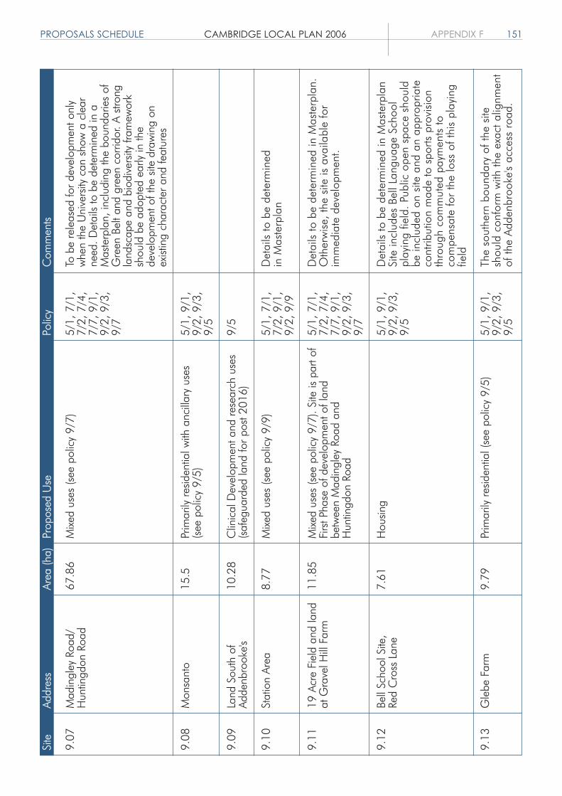
PROPOSALS SCHEDULE CAMBRIDGE LOCAL PLAN 2006 APPENDIX F 151Si
teN
o9.
07
9.08
9.09
9.10
9.11
9.12
9.13
Area
(ha)
67.8
6
15.5
10.2
8
8.77
11.8
5
7.61
9.79
Addr
ess
Mad
ingl
ey R
oad/
Hun
tingd
on R
oad
Mon
sant
o
Land
Sou
th o
fAd
denb
rook
e's
Stat
ion
Area
19 A
cre
Fiel
d an
d la
ndat
Gra
vel H
ill F
arm
Bell
Scho
ol S
ite,
Red
Cro
ss L
ane
Gle
be F
arm
Prop
osed
Use
Mixe
d us
es (s
ee p
olic
y 9/
7)
Prim
arily
resid
entia
l with
anc
illar
y us
es(s
ee p
olic
y 9/
5)
Clin
ical
Dev
elop
men
t and
rese
arch
use
s(s
afeg
uard
ed la
nd fo
r pos
t 201
6)
Mixe
d us
es (s
ee p
olic
y 9/
9)
Mixe
d us
es (s
ee p
olic
y 9/
7). S
ite is
par
t of
Firs
t Pha
se o
f dev
elop
men
t of l
and
betw
een
Mad
ingl
ey R
oad
and
Hun
tingd
on R
oad
Hou
sing
Prim
arily
resid
entia
l (se
e po
licy
9/5)
Polic
y
5/1,
7/1
,7/
2, 7
/4,
7/7,
9/1
,9/
2, 9
/3,
9/7
5/1,
9/1
,9/
2, 9
/3,
9/5
9/5
5/1,
7/1
,7/
2, 9
/1,
9/2,
9/9
5/1,
7/1
,7/
2, 7
/4,
7/7,
9/1
,9/
2, 9
/3,
9/7
5/1,
9/1
,9/
2, 9
/3,
9/5
5/1,
9/1
,9/
2, 9
/3,
9/5
Com
men
ts
To b
e re
leas
ed fo
r dev
elop
men
t onl
yw
hen
the
Uni
vers
ity c
an s
how
a c
lear
need
. Det
ails
to b
e de
term
ined
in a
Mas
terp
lan,
incl
udin
g th
e bo
unda
ries
ofG
reen
Bel
t and
gre
en c
orrid
or. A
stro
ngla
ndsc
ape
and
biod
iver
sity
fram
ewor
ksh
ould
be
adop
ted
early
in th
ede
velo
pmen
t of t
he s
ite d
raw
ing
onex
istin
g ch
arac
ter a
nd fe
atur
es
Det
ails
to b
e de
term
ined
in M
aste
rpla
n
Det
ails
to b
e de
term
ined
in M
aste
rpla
n.O
ther
wis
e, th
e si
te is
ava
ilabl
e fo
rim
med
iate
dev
elop
men
t.
Det
ails
to b
e de
term
ined
in M
aste
rpla
nSi
te in
clud
es B
ell L
angu
age
Scho
olpl
ayin
g fie
ld.
Publ
ic o
pen
spac
e sh
ould
be in
clud
ed o
n si
te a
nd a
n ap
prop
riate
cont
ribut
ion
mad
e to
spo
rts p
rovi
sion
thro
ugh
com
mut
ed p
aym
ents
toco
mpe
nsat
e fo
r th
e lo
ss o
f thi
s pl
ayin
gfie
ld
The
sout
hern
bou
ndar
y of
the
site
shou
ld c
onfo
rm w
ith th
e ex
act a
lignm
ent
of th
e Ad
denb
rook
e's
acce
ss r
oad.

152 APPENDIX F CAMBRIDGE LOCAL PLAN 2006 PROPOSALS SCHEDULESi
te N
o
9.14
9.15
9.16
Area
(ha)
1.44
1.51
1.29
Addr
ess
Land
bet
wee
n 64
-66
Peve
rel R
oad
Land
bet
wee
n H
ills
Road
and
Sta
tion
Road
(Tria
ngle
Site
)
Mar
shal
ls N
orth
Wor
ks
Prop
osed
Use
Hou
sing
Hou
sing
Hou
sing
Polic
y
5/1
5/1,
9/1
,9/
2, 9
/9
5/1
Com
men
ts
Det
ails
to b
e de
term
ined
inM
aste
rpla
n
Part
of la
rge
deve
lopm
ent n
orth
of
New
mar
ket R
oad

BIBLIOGRAPHY CAMBRIDGE LOCAL PLAN 2006 APPENDIX G 153
BIBLIOGRAPHYAccessible Natural Greenspace in Townsand Cities
Ancient Monuments and ArcheologicalAreas Act
Areas Transport Plans
BS 7913 – Guide to the Principles of theConservation of Historic Buildings BuildingRegulations – Part M
Buildings of Local Interest
Cambridge Green Belt Study
Cambridge Green Belt towards 2016
Cambridge Housing Needs Study
Cambridge Landscape CharacterAssessment
Cambridge Local Plan (1996)
Cambridge Shopfront Design Guide
Cambridge Sub-region Key WorkerHousing Research
Cambridge Walking and CyclingStrategy and Action Plan
Cambridgeshire and PeterboroughWaste Local Plan
Cambridgeshire and PeterboroughStructure Plan
Cambridgeshire Transport Plan 2001-2006
Cambridgeshire's Local BiodiversityAction Plan
Character of England: Landscape,Wildlife and Natural Features
English Nature – C.Harrison, J. Burgess, A.Millward,G. Dawe; No 153 (1995)
Secretary of State for Culture, Media and Sport(1979)
See Corridor Area Transport Plans
Approved Document M: 'Access and Facilities forDisabled People' (1999)
List prepared by the Cambridge City Council(Environment & Planning Department)
Landscape Design Associates (2002)
Cambridge City Council (November 1998)
Cambridge City Council (2003)
Cambridge City Council (January 2003)
Cambridge City Council (November 1996) Other references to Cambridge Local Plan refer tothis Local Plan
Cambridge City Council (November 1997)
Cambridge Sub-region Affordable Housing Group(August 2003)
Cambridge City Council (September 2002)
Cambridgeshire County Council and PeterboroughCity Council (2003)
Cambridgeshire County Council (2003)
Cambridgeshire County Council (July 2000)
Biodiversity Cambridgeshire; contact viaCambridgeshire County Council (1999)
Countryside Commission (now Countryside Agency)and English Nature (1996)

154 APPENDIX G CAMBRIDGE LOCAL PLAN 2006 BIBLIOGRAPHY
Circular 05/2005: Planning Obligations
Citizens Panel Survey: The Developmentof Cambridge
Community Strategy
Conservation Area Appraisal
Corridor Areas Transport Plans
Countryside and Rights of Way Act 2000
Criteria for Designation for County andCity Wildlife Sites
Design Quality Indicators
DOE Circular 1/92: Planning Controlsover Sites of Special Scientific Interest
Environment Act 1995
Gardens of Local Interest
Hillier Parker Study: Cambridgeshireand Peterborough Structure PlanReview Retail Study
Historic Core Conservation AreaAppraisal
Office of the Deputy Prime Minister (July 2005)
Cambridge City Council (February 2001)
Cambridge City Council (Local StrategicPartnership)
The following Appraisals have been produced bythe Cambridge City Council: Trumpington (Aug. 98) Brooklands Avenue Area (May 2002) Southacre (Feb. 2000) Mill Road and St Matthews Area (Oct. 99) Newnham Croft (April 99) The Kite (June 96)
Under preparation/to be prepared are: Chesterton Conduit Head Road Storey's Way West Cambridge Castle (part of the Central Conservation Area) Newtown (part of the Central Conservation Area) Riverside (part of the Central Conservation Area) Historic Core (part of the Central Conservation
Area)
Cambridge City Council; adopted plans: Southern Corridor Area Transport Plan (2002) Eastern Corridor ATP (2002) Western Corridor ATP (2003) Northern Corridor ATP (2003).
HMSO (2000)
Cambridge City Council (June 2000)
Construction Industry Council (2002)
HSMO (1992)
HMSO (1995)
List to be produced by Cambridge City Council(Environment & Planning Department)
Cambridge County Council, Peterborough CityCouncil and Cambridge City Council (July 2001)
See Conservation Area Appraisals
BIBLIOGRAPHY CAMBRIDGE LOCAL PLAN 2006 APPENDIX G 155
Historic Parks and Gardens
Implementing the CambridgeSub-Regional Study
Informed Conservation
Lifetime Home Standard
Local Biodiversity Action Plan
Local Plan Issues Report: CambridgeLocal Plan Issues Report 2001
Local Plan Monitoring Report: CambridgeLocal Plan Monitoring Report
Local Transport Plan
Meeting Part M and Designing LifetimeHomes
National Biodiversity Action Plan (UK BAP)
NHS Trust's 2020 Vision: Addenbrooke's– The 2020 Vision
Open Space and Recreation Strategy
Parking Standards
Planning (Listed Building & ConservationAreas) Act 1990
Planning and Compulsory Purchase Act2004.
Planning Obligation Strategy
Planning Obligations: Delivering aFundamental Change
Planning: Delivering a FundamentalChange (Green Paper)
PPG 10 – Planning and WasteManagement
PPG 15 – Planning and the HistoricEnvironment
See Register of Historic Parks and Gardens
Roger Tym & Partners (October 2001)
English Heritage (2001)
Joseph Rowntree Foundation (2000)
See Cambridgeshire's Local Biodiversity Action Plan
Cambridge City Council (June 2001)
Cambridge City Council (1999)
Cambridgeshire Transport Plan 2001-2006 Cambridgeshire County Council (under review)
Joseph Rowntree Foundation (1999)
Biodiversity: the UK Action Plan; HMSO (1994)
Addenbrooke's NHS Trust; three documents:– 'The Future of the Addenbrooke's Hospital Site'(September 1999)– 'The Future of the Addenbrooke's Site' (UpdateJune 2001)– '2020 Vision at Addenbrooke's' (2004)
Cambridge City Council (2004)
Cambridge City Council (2004)
HMSO (1990)
HMSO (2004)
Cambridge City Council (2004)
Office of the Deputy Prime Minster (19 December2001/updated 13 May 2002)
Office of the Deputy Prime Minster (December2001)
Office of the Deputy Prime Minister (1999)
DETR (1994); also update DETR Circular 14/97

156 APPENDIX G CAMBRIDGE LOCAL PLAN 2006 BIBLIOGRAPHY
PPG 17 – Sport and Recreation
Principles of the Conservation of HistoricBuildings
Public Art
Regional Planning Guidance (RPG6) forEast Anglia, covering the counties ofCambridgeshire (including Peterborough),Norfolk and Suffolk
Register of Historic Parks and Gardens
Research into Key Worker & AffordableHousing in the Cambridge Area
Retail Study
Species and Habitats Directive (CouncilDirective 92/43/EEC)
Sports Provision in Cambridge StructurePlan
Structure Plan Review Retail Study
Sustainability Appraisal of the DepositDraft Local Plan
Sustainable Development Guidelines
Tourism Strategy: Cambridge TourismStrategy 2001-2006
Town and Country Planning (DevelopmentPlan) (England) Regulations
Town and Country Planning (GeneralPermitted Development) Order
Town and Country Planning(Use Classes) Order
Town and Country Planning Acts
Urban Archeological Database
Urban Capacity Study: Cambridge UrbanCapacity Study 2002
Wildlife and Countryside Act
Office of the Deputy Prime Minister (1991)
See BS 7913
Cambridge City Council (July 2002)
Secretary of State for the Environment, Transportand the Regions (November 2000)
English Heritage (1980, update planned for 2003)
University of Cambridge, Cambridge Housing, Planning Research (2002)
See Hillier Parker Study
European Community (1992)
Cambridge City Council (2004)See Cambridgeshire and Peterborough StructurePlan
See Hillier Parker Study
Levett-Therivel (June 2003)
Cambridge City Council (2003)
Cambridge City Council (June 2001)
HSMO (1999)
HSMO (1995)
HSMO (1987)
HMSO (1990 and 1991)
Cambridgeshire County Council and CambridgeCity Council in collaboration with CambridgeUniversity (under development)
Cambridge City Council (September 2002)
HSMO (1981)

GLOSSARY CAMBRIDGE LOCAL PLAN 2006 APPENDIX H 157
GLOSSARY
Affordable housing
Affordable supported housing
Area Action Plan (AAP)
Area Development Framework(ADF)
Area Transport Plans (ATP)
Biodiversity
Biotechnology
Brownfield land
Building of Local Interest
Housing provided for people who cannot afford to rent or buyhousing locally on the open market to meet their housingneeds. It includes affordable supported housing and can referto dwellings offered at a reduced rent/price.
For particular client groups requiring additional managementsupport and who cannot afford to rent or buy housing on theopen market.
A Local Development Document setting out policy andproposals for specific areas. See Planning and CompulsoryPurchase Act 2004 and its supporting guidance andregulatory documents.
To be prepared by the Local Authority and Partners workingwith consultants setting out how the Local Plan policies will beachieved. It will provide firm guidelines on the layout anddesign philosophy, structure of open space, transport andaccess arrangements and developer contributions and may ormay not be adopted as SPD.
Identifies the Transport schemes necessary as a result ofdevelopments that are likely to take place in an area. Theyare a way of spreading the costs of large transport schemesacross all significant developments. Four Area Transport Planshave been prepared for the Southern, Eastern, Northern andWestern Corridors. All the plans have been adopted byCambridge City Council as Supplementary PlanningGuidance; see bibliography.
All aspects of biological diversity, especially including speciesrichness, ecosystem complexity and genetic variation.
The application of science and engineering to the direct orindirect use of living organisms, or parts or products of livingorganisms, in their natural or modified forms.
Previously developed land (PDL) which is or was occupied bya permanent structure (excluding agricultural or forestrybuildings), and associated with fixed surface infrastructure.The definition covers the curtilage of development. Previouslydeveloped land can occur in both urban and rural settings.
A non-statutory listing of buildings, which are important to thelocality or the City's history and architectural development.
NOTE: The information in this Glossary is an informal, non-technical explanation of some terms andphrases used in the Local Plan.
158 APPENDIX H CAMBRIDGE LOCAL PLAN 2006 GLOSSARY
Building Regulations
Cambridge Local Plan
Cambridge Phenomenon
Cambridgeshire &Peterborough Waste Local Plan
Carter Bridge
Chalklands
Character Map of England
Cherry Hinton Pit
City
City Centre
City Council
City wide
City Wildlife Site (CiWS)
Cluster
Building Regulations ensure the health and safety of people inand around buildings by providing functional requirements forbuilding design and construction. In addition, the Regulationspromote energy efficiency in buildings and contribute tomeeting the needs of disabled people. Builders anddevelopers are required by law to obtain building controlapproval – an independent check that the BuildingRegulations have been complied with. There are two types ofbuilding control providers – the Local Authority and ApprovedInspectors.
The current Cambridge Local Plan (2006), which sets outpolicies and proposals for future development and land use to2016; the Plan will be a material consideration when makingplanning applications.
Refers to the large number of high technology companies inand around Cambridge; first described by Segal Quince &Partners.
Document addressing the land-use planning aspects of wastemanagement; prepared by the Cambridgeshire CountyCouncil and Peterborough City Council as part of theDevelopment Plan; see bibliography.
A pedestrian and cycle bridge linking Coleridge with thewestern side of the train station.
As defined by the Character Map of England.
See Bibliography – Character of England
Chalk pits south of Limekiln Close and east and west ofLimekiln Road; designated SSSI.
Cambridge as per administrative boundary of Cambridge CityCouncil.
Historic Core and Fitzroy/Burleigh Street shopping areas inCambridge. These areas provide a range of facilities andservices, which fulfil a function as a focus for both thecommunity and for public transport; see also Proposals Map.
Cambridge City Council.
Within the area administered by the Cambridge City Council.
Designated by Cambridge City Council and the Wildlife Trust.
Concentrations of companies in related activities,recognizable suppliers, service providers and institutions,which are co-operating, competing and collaborating to buildcompetitive advantage, often across traditional sectorboundaries. Such concentrations often depend on access tospecialist skills and infrastructure within a specific area.

GLOSSARY CAMBRIDGE LOCAL PLAN 2006 APPENDIX H 159
Colleges constituting part of Cambridge University. Each is anindependent corporate body with its own governance,property and finance. There are 31 such Colleges. TheColleges appoint their staff and are responsible for selectingstudents, in accordance with University regulations. Theteaching of undergraduates is shared between the Collegesand University departments. Degrees are awarded by theUniversity. Academic staff in some cases hold dualappointments, one with the University and one with a College.
Facilities, which help meet the varied needs of the residents ofCambridge for health, educational and public services as wellas social, cultural and religious activities. For the purposes ofthe Local Plan, community facilities are defined as uses fallingwithin Class D1 "Non residential institutions" of the Use ClassOrder with the exception of university teachingaccommodation. In addition, the following subcategories ofClass C2 "Residential Institutions" are considered to becommunity facilities: hospitals, residential schools, colleges ortraining centres; see paragraphs 5.20-5.24.
Prepared by the City's Local Strategic Partnership.
Goods that are purchased occasionally and for longer termuse, such as electrical goods, clothing, household goods,books, jewellery, furniture etc which consumers will comparebefore making a choice (see also convenience goods orshopping).
Areas identified by the City Council, which have 'specialarchitectural or historic interest', which makes them worthprotecting and improving.
Produced by the City Council covering various ConservationAreas within the City; see also Bibliography.
Touching along the side or boundary; in contact; physicallyadjacent; neighbouring.
A controlled parking zone is an area in which all roads havewaiting restrictions in some form. It is defined through TrafficRegulation Orders, and by entry/exit points to the zone, whichare indicated by relevant road signs. For the purposes of theCar Parking Standards, a site will be deemed to be within theControlled Parking Zone (CPZ) if its access point to theexisting highway network lies within the controlled zonecovering the central area of Cambridge City. Note that theCPZ is already in force and is not a proposal of the LocalPlan. A separate map is available for illustrative purposes.
Goods that are purchased regularly and for immediateconsumption, such as foods, drink, groceries, confectionery,tobacco, newspapers for which convenience is a primeconsideration.
Colleges
Community facilities
Community Strategy
Comparison shopping
Conservation Area
Conservation Area Appraisals
Contiguous
Controlled Parking Zone (CPZ)
Convenience shopping

160 APPENDIX H CAMBRIDGE LOCAL PLAN 2006 GLOSSARY
County
County Council
County Wildlife Site (CWS)
Criteria for Designation ofWildlife Sites
De minimis
Definitive Map
Development Plan
District Centre
Essential Public InfrastructureProviders
Gardens of Local Interest
Geology
Gogs
The area of the County of Cambridgeshire.
Cambridgeshire County Council.
Designated by Cambridge City Council and the Wildlife Trust.
Adopted by the City Council (June 2000) to assess new andexisting wildlife sites, to be included in a Wildlife Strategy SPDto be prepared.
The full expression is 'de minimis non curat lex'. This is a Latinphrase which means "the law does not care about very smallmatters". It can be used to describe a component part of awider transaction, where it is in itself insignificant orimmaterial to the transaction as a whole, and will have nolegal relevance or bearing on the end result.
The Map is a legal record of the public's rights of way. Themaps are produced by the Local Authority (in Cambridge bythe Cambridgeshire County Council). Note there may beadditional rights over land, which have not yet been recordedon the map or there may be rights, which are incorrectlyrecorded on the map.
The Development Plan for Cambridgeshire is not a singledocument but comprises of a number of documents asrequired by legislation. These are: the Cambridgeshire &Peterborough Structure Plan, the Cambridgeshire andPeterborough Waste Local Plan, the Cambridgeshire LocalTransport Plan and the Cambridge Local Plan. TheDevelopment Plan is prepared in accordance with the Townand Country Planning (Development Plan) (England)Regulations 1999 and the Town and Country Planning(Transitional Arrangements) (England) Regulations 2004.
Group of shops, separate from the town centre, usuallycontaining at least one food supermarket or superstore, andnon-retail services such as banks, building societies andrestaurants; boundaries are defined on the Proposal Map.
Providers of facilities which help meet the essential needs ofthe population of Cambridge and the Sub-region for health,educational and public services, including social, cultural andreligious facilities.
List to be produced by the Cambridgeshire Garden Trust.
The scientific study of the origin, history, and structure of theearth; the structure of a specific region of the earth's crust.
Gog Magog Hills located south east of Cambridge.

GLOSSARY CAMBRIDGE LOCAL PLAN 2006 APPENDIX H 161
Green Belt
Green roof
Greenspaces
Greenfield land
Habitat
High technology
Highway Authority
Historic Parks and Gardens
Household Waste RecyclingCentre (HWRC)
Housing Association
Incubator unit
Infrastructure
Internal Drainage Board
A statutory designation made for the purposes of: checkingthe unrestricted sprawl of large built-up areas, preventingneighbouring towns from merging into each other, assisting insafeguarding the countryside from encroachment, preservingthe setting and special character of historic towns andassisting in urban regeneration by encouraging the recyclingof derelict and other urban land.
Roof covered by a low and light weight vegetation and undera low maintenance regime; see also SuDS.
Open spaces covered with grass and other vegetation.Includes commons, allotments, playing fields, cemeteries,churchyards, large gardens, parks, public open land andagricultural land.
Land which has not previously been developed or which hasreturned to greenfield status over time.
The place of a living organism or community characterized byits physical and/or biotic property.
Activities including production in fields which includebiotechnology, chemicals, consultancy, research anddevelopment, computer components and hardware, computersoftware, electronic systems and products, informationtechnology, instrumentation, new materials technology,telecommunications, other forms of new manufacturingprocess or fields of research and other development whichmay be regarded as high technology uses.
Cambridgeshire County Council.
Listed on the Register of Historic Parks and Gardens; seebibliography.
Run by private companies for Cambridgeshire CountyCouncil. The Centres are operated free of charge formembers of the public but they do not take waste frombusinesses. Taking separated household waste to the sites willreduce the amount of waste going to landfill. Site operatorswill always recycle as much as possible.
Sometimes referred to as a Registered Social Landlord; a nonprofit making organisation which provides housing for peoplein need.
Start up premises for a small firm.
Basic structure of systems such as utilities (gas, electricity,water) drainage, flood defences, transportation, roads,healthcare, education and other community facilities.
At present the Cambridge City Council acts with the samepowers as an internal drainage board or a former LandDrainage Authority
162 APPENDIX H CAMBRIDGE LOCAL PLAN 2006 GLOSSARY
Joint Infrastructure Funding (JIFFunding)
Joseph Rowntree Foundation
Key worker housing
Leisure
Lifetime Homes Standard
Listed Building
Local Biodiversity Action Plan(LBAP)
Local Centre
Local Habitat Action Plans(LHAB)
Local Nature Reserve (LNR)
Local Plan
The Joint Infrastructure Funding is a £750 million partnershipbetween the Welcome Trust, the Office of Science andTechnology and the Higher Education Funding Council forEngland.
Group of housing experts who came together as the JosephRowntree Foundation Lifetime Homes Group; see also LifetimeHomes Standard.
A subset of affordable housing targeted at specific groups ofworkers, including teachers, nurses and others, who areunable to meet their housing needs on the open market.
Includes outdoor and indoor sports, recreation, entertainmentand arts facilities.
In 1991 the Lifetime Homes concept was developed by agroup of housing experts who came together as the JosephRowntree Foundation Lifetime Homes Group. Lifetime Homeshave sixteen design features that ensure a new house or flatwill meet the needs of most households. This does not meanthat every family is surrounded by things that they do notneed. The accent is on accessibility and design features thatmake the home flexible enough to meet whatever comesalong in life: a teenager with a broken leg, a family memberwith serious illness, or parents carrying in heavy shopping anddealing with a pushchair.
A building or structures of special architectural or historicinterest and included in a list, approved by the Secretary ofState. The owner must get Listed Building Consent to carry outalterations, which would affect its character.
The Action Plan works on the basis of partnership to identifylocal priorities and to determine the contribution they canmake to the delivery of the national Species and HabitatAction Plan targets. The Local Biodiversity Action Plans hasbeen prepared by Biodiversity Cambridgeshire (contact viaCambridgeshire County Council) 1999.
Small grouping usually comprising a newsagent, a generalgrocery store, a sub-post office and occasionally a pharmacy,a hairdresser and other small shops of a local nature;boundaries are defined on the Proposal Map.
Part of the Cambridgeshire's Biodiversity Action Plans,published by Biodiversity Cambridgeshire (contact viaCambridgeshire County Council) 1999.
Reserves with wildlife or geological features that are of specialinterests locally.
Abbreviation used to describe the current Redeposit DraftCambridge Local Plan (2004).

GLOSSARY CAMBRIDGE LOCAL PLAN 2006 APPENDIX H 163
Local Species Action Plan(LSAP)
Local Transport Plan (LTP)
Low impact building materials
Masterplan
Material consideration
Mitigation
Mixed use development
National Biodiversity Action Plan
Natural Environment
Natural or semi-naturalgreenspace
Open space
Part of the Cambridgeshire's Biodiversity Action Plans,published by Biodiversity Cambridgeshire (contact viaCambridgeshire County Council) 1999.
Cambridgeshire Transport Plan 2001-2006 CambridgeshireCounty Council; currently under review.
Materials, which have a low impact on the environment duringtheir lifetime (including during their production, transport,installation and maintenance).
A masterplan describes how proposals for a site will beimplemented. The level of detail required in a masterplan willvary according to the scale at which the masterplan isproduced. Masterplans will normally be adopted as SPD.
Something, which should be taken into account when makingplanning decisions such as determining planning applications.
The purpose of mitigation is to avoid, reduce and wherepossible remedy or offset any significant negative (adverse)effects on the environment etc arising from the proposeddevelopment.
Development comprising two or more uses as part of the samescheme. This could apply at a variety of scales from individualbuildings, to a street, to a new neighbourhood or urbanextension. Mixed use development can help create vitality anddiversity and can help to reduce the need to travel, which ismore sustainable.
Biodiversity: the UK Action Plan; see bibliography.
Areas which protect the setting and character of Cambridgeand which often provide habitats and refuges for flora andfauna. It includes the flora and fauna contained within theopen spaces.
Natural or semi-natural greenspace includes woodland, scrub,grassland such as commons and meadows, wetlands, openand running water, wastelands and derelict open land and rockareas (e.g. cliffs, quarries and pits) – all actively managed byhumans in need to maintain native wildlife and sustain humanbeings. In other words these are managed environmentsincluding 'encapsulated countryside within the formallydesignated public open spaces' and elsewhere (ref. EnglishNature – Accessible natural greenspace in towns and cities).
Includes all open space of public value. There is a broadrange of spaces that may be of public value – not just land butalso areas of water such as rivers and lakes – and includes,parks and gardens; natural and semi-natural urbangreenspaces; green corridors; outdoor sports facilities; amenitygreenspace; teenagers and children's play areas; allotmentsand community gardens; cemeteries and churchyards;accessible countryside in urban fringe areas and civic spaces.

164 APPENDIX H CAMBRIDGE LOCAL PLAN 2006 GLOSSARY
Open Space Standards
Park and Ride (P & R)
Parking Standards
Permissive Right of Way
Physiographical
Planning Authority
Planning Condition
Planning Obligation
Planning Obligation Strategy
Planning Policy Guidance Note(PPG)
Previously Developed Land(PDL)
Primary Shopping Frontages(PSF)
Proctorial control
Proposals Map
The amount of open space required in all developments eitheron site or through commuted payments.
A system where private motorists are encouraged to leavetheir car at an out of centre public car park and travel the restof the way to their destination by public transport.
Document setting out maximum permissible levels of carparking for various use-classes, along with minimum levels ofcycle parking; see bibliography.
It is possible for landowners to allow access over their landwithout dedicating a right of way. These accesses are calledpermissive paths. Permissive paths are commonly found onland owned by a body, which allows public access, such as alocal authority, a Railway Authority, or the National Trust.
Of or pertaining to physiography: From physiography orgeomorphology or physical geography.
In the City it is Cambridge City Council.
Requirement attached to a planning permission. It may controlhow the development is carried out, or the way it is used inthe future. It may require further information to be provided tothe City Council before or during the construction.
A binding legal agreement requiring a developer orlandowner to provide or contribute towards facilities,infrastructure or other measures, in order for planningpermission to be granted. Planning Obligations are normallysecured under Section 106 of the Town & Country PlanningAct 1990.
An SPG produced by the Cambridge City Council, seeBibliography.
The guidance is issued on a range of planning issues by the(former) Department of the Environment, Transport and theRegions, Department of Transport, Local Government and theRegions and now the Office of the Deputy Prime Minister.PPGs must be taken into account when preparing the statutoryLocal Plan.
See brownfield land.
Streets in the City Centre defined on the Proposals Map whichare predominantly in retail use.
Rules and Regulations covering the conduct of universitystudents in Cambridge, such as restrictions on car ownership.The enforcement staff are called Proctors.
Map, which is part of the Local Plan showing all designationsand site allocations.

GLOSSARY CAMBRIDGE LOCAL PLAN 2006 APPENDIX H 165
Proposals Schedule
Protected Open Space
Public Art
Public Right of Way
Rapid Transit System (RTS)
Regional Planning Guidance(RPG)
Registered Social Landlord(RSL)
Research & Development(R & D)
Research establishments
Residents Parking Zones (RPZ)
Retail warehouses
Ridge and furrow
List setting out all the sites allocated in the Local Plan,generally ordered by size within each chapter.
Open Space protected by Policy 4/2; see paragraph 4.7.
Publicly sited works of art, which make an importantcontribution to the character and visual quality of the City andis accessible to the public. Details as per adopted Public ArtSPG; see bibliography.
A public right of way is a route over which the public has aright to pass and re-pass. Public rights of way are morecommonly known as either: Footpath (for use on foot only),Bridleway (for use by horses, pedal cycle or on foot), Byway(for use by motor vehicles, horses, pedal cycle or on foot).Public footpaths are not to be confused with highway footways,which are pavements to the side of the road. Public right ofways are legally recorded on the Definitive Map. Wildlife andCountryside Act 1981 and Countryside and Rights of Way Act2000.
Rail or motor bus transit service operating completely separatefrom any other modes of transportation (fully or partially) on anexclusive right of way.
RPG6 – for East Anglia, covers the counties of Cambridgeshire(including Peterborough), Norfolk and Suffolk and waspublished by the Secretary of State for the Environment,Transport and the Regions on 23 November 2000.
An organisation registered by the Housing Corporation toprovide affordable housing.
The investigation, design and development of an idea,concept, material, component, instrument, machine, productor process, up to and including production for testing (notmass production), where the work routine requires dailydiscussion and action on the part of laboratory and designstaff.
Research establishments/institutions include commercialresearch facilities and sui generis uses affiliated with one of theUniversities, the Medical Research Council or Addenbrooke'sHospital, where there is a need for regular day-to-day contactor sharing of materials, staff and equipment.
Residents Parking Zones are established by the HighwayAuthority and cover an area of on street parking restricted tolocal residents only.
Large single-level stores specializing in the direct sale ofhousehold goods and bulky items to the public, cateringmainly for car borne customers.
Refers to the 'ridge and furrow' field systems.

166 APPENDIX H CAMBRIDGE LOCAL PLAN 2006 GLOSSARY
Scheduled Ancient Monument
Secondary shopping frontage
Section 106
Sequential test
Setting of the City
Shopping floorspace
Site of Special Scientific Interest(SSSI)
South Cambridgeshire
Southern Fringe
Station Area
Streetscape
Structure Plan
Sub-region
Scheduled Ancient Monument – Archeological sites, burieddeposits or structures of national importance by virtue of theirhistoric, architectural, traditional or Archeological interest.They are scheduled by the Secretary of State for Culture,Media and Sport under the Ancient Monuments andArcheological Areas Act 1979.
That part of a shopping centre outside the Primary Frontageusually on the fringe, where units are generally smaller andthere is a higher proportion of non-retail uses.
See Planning Obligations.
A test applied when selecting sites for development, as set outin PPG6 – Town Centres and Retail Development. This meansthat first preference should be for sites in the City Centrewhere suitable sites or buildings for conversion are available.This is followed by edge-of-centre sites, district and localcentres and only then out-of-centre sites in locations that areaccessible by a choice of means of transport.
The interface between the urban edge and the countryside;see also Cambridge Landscape Character Assessment.
The total area covered by sales in shopping developments.
An area which, in the view of English Nature, is of particularinterest because of its fauna, flora, or geological orphysiographic features. Once designated, the owner of thesite is required to notify the relevant authorities and to obtainspecial permission before undertaking operations that wouldalter its characteristics. Designated under Section 28 of theWildlife and Countryside Act 1981.
South Cambridgeshire District Council.
As defined on the Proposals Map.
Refer to Proposals Map.
The overall character, design quality, and particular physicalelements which are formed by a combination of buildingfacades, signage, paving, street furniture (seats, bins, cycleracks etc), lighting and tree and other plantings as well asother elements along a street. The quality of these elementsand the degree to which they compliment each otherdetermine the quality of the streetscape.
The Cambridgeshire and Peterborough Structure Plan whichsets out the broad requirements for new homes, industry,shops and supporting services and infrastructure; see alsobibliography.
Cambridge area extending to and including surrounding ringof market towns.

GLOSSARY CAMBRIDGE LOCAL PLAN 2006 APPENDIX H 167
Sui generis
Supplementary PlanningGuidance (SPG)/Supplementary PlanningDocument (SPD)
Supported housing
Sustainable
Sustainable Development
Sustainable Drainage Systems(SuDS)
Swale
Transport
Transport Assessment (TA)
Those uses not allocated to a particular Use Class in TheTown and Country Planning (Use Classes) Order 1987.
Do not form part of the Local Plan. Can take the form ofdesign guides or area briefs, or supplement other specificpolicies in a plan. SPG/SPD may be taken into account as amaterial consideration in making planning decisions such asdetermining planning applications.
Housing for particular client groups requiring additionalmanagement support such as people with learning difficulties,young people at risk, the frail elderly, the blind, mentally ill ormentally handicapped people and women with dependentsrequiring refuge from harassment and violence, but notincluding student hostels.
Regarding economic development, energy sources etc:capable of being maintained at a steady level withoutexhausting natural resources or causing severe ecologicaldamage (see also sustainable development).
Sustainable Development is a very broad term thatencompasses many different aspects and issues from theglobal to local levels. Overall sustainable developmentdescribed as: 'Development, which meet the needs of thepresent without compromising the ability for the futuregenerations to meet their own needs' (after the 1987 Report ofthe World Commission on Environment and Development– the Brundtland Commission); detail as per proposed'Sustainable Development Guidelines SPG.
Development normally reduces the amount of water whichcan infiltrate into the ground and increases surface water runoff due to the amount of hard surfacing used. Sustainabledrainage systems control surface water run off by mimickingnatural drainage process through the use of surface waterstorage areas, flow limiting devices and the use of infiltrationareas or soakaways etc.
A natural depression or a shallow ditch to temporarily convey,store (i.e. take extra water volume in storm conditions) or filterrunoff/surface water. Swales can act as linear soakaways (thesurface water may seep into the natural ground). The swale isgenerally lined with grass so it can be used to improve runoffquality by filtering suspended sediment and heavy metalswithin the surface drainage system.
The system transporting goods or people.
The Assessment [or Consideration] of the potential transportimpacts of a proposed development, with an agreed plan toreduce or mitigate any adverse consequences and whereappropriate establish how more sustainable modes of travelcan be increased.

168 APPENDIX H CAMBRIDGE LOCAL PLAN 2006 GLOSSARY
Travel Plan
Traveller(s)
Travellers's Rest Pit
Triangle Site
University of Cambridge
Urban Archeological Database(UAD)
Urban Capacity Study (UCS)
Urban design
Urban Extensions
Package of measures tailored to a particular site, aimed atpromoting more sustainable travel choices (such as walking,cycling, public transport) and reducing car use. It may includeinitiatives such as car sharing schemes, provision of cyclefacilities, improved bus services, and restricting or charging forcar parking.
Refers to travelling people or folk or travelling communitiessuch as Gypsies or other itinerant people.
A site south of Huntingdon Road (north of Conduit HeadRoad); a declared SSSI.
An area between Station Road, Hills Road and the railway line.
The University of Cambridge is a common law corporation. Itis a loose confederation of faculties, Colleges and otherbodies. The University works with a relatively small centraladministration and with central governing and supervisorybodies consisting of and mainly elected by, the currentacademic personnel of the faculties and Colleges. There areover 100 departments, faculties and schools in which theacademic and other staff of the University provide formalteaching (lectures, seminars and practical classes) and carryout research and scholarships. In relation to land and propertythe University is distinct from the 31 colleges.
This database is being established through a partnershipbetween the County Council, City Council and EnglishHeritage aided by Cambridge University. It currently covers theCity Centre only.
A systematic approach taken in assessing the developmentpotential for sites and buildings, normally for residentialdevelopment; see bibliography.
Urban design concerns the relationship between differentbuildings; the relationship between buildings and streets,squares, parks, waterways and other spaces which make upthe public domain; the nature and quality of the public domainitself; the relationship of one part of a village, town or city withother parts; and the patterns of movement and activity whichare thereby established. In short urban design is the complexrelationships between all the elements of built and unbuiltspace.
Development areas on the edge of Cambridge on landproposed for release from the Green Belt – this includesbrownfield and Greenfield land. Such development isproposed to the edge of the City at a sustainable location.Cambridge's urban extensions are – Northern Fringe (9.04),Southern Fringe (9.02, 9.05, 9.06, 9.09, 9.10, 9.13, 9.14),East Cambridge (9.01, 9.17, 9.19), Huntingdon Road/HistonRoad (9.03) and Land between Madingley Road & HuntingdonRoad (Phase 1: 9.12, 9.15, 9.16; Phase 2: 9.07 &Phase 3: 9.08).

GLOSSARY CAMBRIDGE LOCAL PLAN 2006 APPENDIX H 169
Use Class Order
Use Class A1
Use Class A2
Use Class A3
Use Class A4
Use Class A5
Use Class B1(a)
Use Class B1(b)
Use Class B1(c)
Use Class B2
Use Class B8
Use Class C2
Use Class D1
Waste Local Plan
Windfall site(s)
The Town and Country Planning (Use Classes) Order 1987(as amended) established Use Classes, which is a system ofcategories referred to in the Local Plan:
Shops where the sale, display or service is to visiting membersof the public (shops, hairdressers etc.)
Financial and professional services where the services areprovided principally to visiting members of the public (banks,estate agents etc.)
Use for the sale of food or drink for consumption on thepremises
Use as a public house, wine bar or other drinkingestablishment (but not a nightclub)
Use for the sale of hot food for consumption off the premises
An office other than within class A2 (financial and professionalservices)
Research and development of products or processes
Any industrial process that can be carried out in anyresidential area without detriment to the amenity of that area
General industrial uses
Use for storage or as a distribution centre
Residential institutions considered to be community facilities
Non-residential institutions (health centres, schools etc.).
This document addresses the land-use planning aspects ofwaste management; prepared by the Cambridgeshire CountyCouncil and Peterborough City Council as part of theDevelopment Plan.
A site which becomes unexpectedly available for development(usually for housing) during the Plan period and which theLocal Plan has not already defined as a potential developmentsite.