cambridge south east transport study · cambridge south east transport study proposals. what are we...
TRANSCRIPT

Have your say on
• new public transport links
• new and improved walking and cycling routes
• road safety improvements
Please respond to the consultation by Tuesday 3 April 2018. www.greatercambridge.org.uk/CambridgeSouthEastConsultation
CAMBRIDGE SOUTH EAST Transport Study
Consultation extended to 9 April

Hello,
Thank you for taking the time to read our consultation brochure. The Cambridge South East Transport Study (formerly known as the A1307, Three Campuses to Cambridge project) aims to deliver fast and reliable public transport links, serviced by a new Park & Ride site, together with high-quality cycling and walking routes, for people travelling between Cambridge and the towns and villages to the south east of the city.
We need your views so that we can create the best scheme for the area, now and in the future. There are proposals for a Cambridge metro based on innovative rail-less trams. These have more flexibility than a rail-based system, but the most effective implementation is on dedicated segregated routes.
As the UK’s fastest-growing place, we are proud of our economic success but, as a result, our roads must cope with more and more traffic. As Greater Cambridge continues to prosper this will become worse, placing greater pressure on our congested highways, affecting our businesses, residents and the many people who travel in and around the area. If we don’t act now, by 2031, time spent in traffic jams could increase by 50%, and the quality of air we breathe will deteriorate. To address this, the Cambridgeshire & Peterborough Combined Authority (Combined Authority) and the Greater Cambridge Partnership want to deliver new transport infrastructure which offers a real alternative to driving.
Since consulting with you in 2016 and carefully considering your comments, the proposals have been developed into three long-term public-transport-focused strategies to the south east of Cambridge alongside a range of improvements to the existing A1307. All strategies include high-quality walking and cycling facilities.
Whether you live, work, study or travel in or through the area, we are keen to hear your views. You can find out more about the project here, online or at a local event. There is a free postal questionnaire for your comments, or alternatively you can respond online at www.greatercambridge.org.uk/CambridgeSouthEastConsultation.
Please take the time to give us your views, so we can help to grow and share prosperity and improve quality of life for everyone in the area, now and in the future.
Thank you for your time.
Cllr Francis Burkitt Chair of the Greater Cambridge Partnership Executive Board
CONTENTS
3 The Transport Network
4 Why do we need better public transport links?
5 The story so far
6 Cambridge South East Transport Study proposals
7 Scheme aims
8 Phase 1 - Elements common to all strategies
14 Phase 2 - Three public transport strategies
15 Strategy 1 - Mass Rapid Transit route 16 Strategy 2 - Bus lanes & public transport link
17 Strategy 3 - Bus lanes
18 Strategy comparison
20 A Connected Transport Network
22 We welcome your views
23 Next steps
The Cambridge South East Transport Study was formerly known as the A1307, Three Campuses to Cambridge project.
2

THE TRANSPORT NETWORK
A range of Greater Cambridge Partnership (GCP) schemes are underway to contribute to the development of a better, greener transport network for our busy city region.
This high-level map shows how our current projects (in 2025) connect the city with the surrounding area, to help it grow and evolve. The Cambridge South East Transport Study is part of wider proposals by Combined Authority and GCP to improve transport links in the area and is shown in orange in the bottom right of the map.
The GCP is the local councils, business and academic partnership responsible for delivering a ‘city deal’. This Government-funded investment in Cambridge and South Cambridgeshire will help our local economy grow sustainably over the coming years. Through investment in key services and transport infrastructure, our partnership will deliver new homes and jobs and connect people to places of employment. GCP is working with the Combined Authority to deliver investment in transport.
What is the Greater Cambridge Partnership (GCP)?
More detail about projects connected to the Cambridge South East Transport Study proposals can be found on page 20 of this booklet and online at www.greatercambridge.org.uk
3

WHY DO WE NEED BETTER PUBLIC TRANSPORT LINKS?
44,000+ NEW JOBS TO BE CREATED IN OR NEAR CAMBRIDGE BY 2031*
MORE THAN 8,000 HOMES PROPOSED FOR THE AREA SOUTH EAST OF CAMBRIDGE
50%longer
NOW 2031
JOURNEY TIMES BETWEEN A11 AND CAMBRIDGE, WITH NO ACTION...
*Source: The South Cambridgeshire Local Plan and the Cambridge Local Plan
THE IMPACT OF GROWTH WITHOUT TRANSPORT IMPROVEMENTS ...
44,000+ NEW JOBS TO BE CREATED IN OR NEAR CAMBRIDGE BY 2031...*
MORE THAN 8,000 HOMES PLANNED IN THE CAMBOURNE TO CAMBRIDGE AREA ALONE BY 2031,* WITH A FURTHER 3,700 PLANNED AT ST NEOTS
23 45mins mins
NOW 2031
INCREASING JOURNEY TIMES BETWEEN MADINGLEY MULCH ROUNDABOUT AND CAMBRIDGE, WITH NO ACTION...
*Source: The South Cambridgeshire Local Plan and the Cambridge Local Plan
THE IMPACT OF GROWTH WITHOUT TRANSPORT IMPROVEMENTS ...
The proposals will provide additional capacity for the growing number of journeys to, from and around Cambridge from the south east. Keep in mind:
• The Local Plans for Cambridge and South Cambridgeshire estimate more than 44,000 additional jobs will have been created in the area by 2031, and local science and research parks in the area have aspirations for continued growth.
• Plans for the area between south Cambridge, Haverhill and Great Chesterford suggest up to 8,000 new homes could potentially be built over the next 15 years, with scope for future growth.
• Parts of the road network are already at capacity at peak-times, impacting on people’s day-to-day lives, the ability of businesses to operate effectively and contributing to pollution.
• If we do not act now and manage growth sustainably, journey times will increase by around 50%.
• By investing in sustainable travel such as public transport, walking and cycling, we can help reduce congestion and its damaging effects on the environment, health and the economy, now and in the future.
• New sustainable transport links will provide existing, new and growing communities to the south east of Cambridge, in South Cambridgeshire and beyond, with improved access to jobs, services and other opportunities in and around the city.
The impact of growth without transport improvements
44

THE STORY SO FAR
On our journey to this point, we have considered a range of options to address congestion and encourage sustainable economic growth in the area south east of Cambridge.
What is a Local Plan?A Local Plan is for the future development of the local area. It is drawn up by district councils in consultation with the community.
APRIL - SEPTEMBER 2017 Options development Workshops with local representatives
NOV 2017 GCP Assembly & Board recommended proposals to go to public consultation
FEBRUARY – MARCH 2018 Public consultation on Cambridge South East Transport Study
2015
2015Early concept development and assessment of potential improvements and routes
MARCH 2016 Initial concepts
MARCH 2017 GCP Assembly & Board recommended further work with Local Liaison Forum and stakeholders
JUNE - AUGUST 2016 Public consultation on initial ideas for bus and cycle links for A1307, Three Campuses to Cambridge
JAN 2018Cambridgeshire Autonomous Metro proposed by Combined Authority
5

CAMBRIDGE SOUTH EAST TRANSPORT STUDY PROPOSALS
What are we consulting on? Following public consultation in 2016 and further development of options in 2017, we have identified three strategies which would help deliver faster, more reliable and sustainable public transport options for journeys between Cambridge and the area to the south east.
Let us know which strategy you prefer by completing the online survey: www.greatercambridge.org.uk/CambridgeSouthEastConsultation or contacting us using the details on page 22.
Shorter-term proposals include bus priority, junction improvements, walking and cycling measures and road safety improvements along the A1307 between Haverhill and Cambridge. If the public consultation shows support for these proposals, it is intended to progress these works as quickly as possible.
Longer-term public transport improvements consist of three high-level strategies:
Strategy 1
• a new segregated Mass Rapid Transit route from the A11 via Sawston to the Cambridge Biomedical Campus
• a Park & Ride near the A11/A505 junction
• would most likely form part of the Cambridgeshire Autonomous Metro being proposed by the Combined Authority
Strategy 2
• a new dedicated public transport link between the existing Babraham Road Park & Ride and the Cambridge Biomedical Campus
• an inbound bus lane from Babraham Research Campus to the Babraham Road Park & Ride site
• a Park & Ride near the A11/A1307 junction
Strategy 3
• an inbound bus lane along the A1307 from Babraham Research Campus to the Addenbrooke’s Hospital roundabout
• a Park & Ride near the A11/A1307 junction
Your feedback will help to develop the strategies further and allow the Executive Board to select a preferred strategy to take forward.
What’s the CAM network?A recent study looking into options for Mass Rapid Transit (commissioned by the Combined Authority and Greater Cambridge Partnership (GCP)) found that a new Metro system is a viable option for Greater Cambridge - providing the capacity and the flexibility to help meet the area’s future transport needs at an affordable price.
The CAM (Cambridgeshire Autonomous Metro) is a high-quality tram-like system, with vehicles that are not restricted to rails; it is a flexible form of public transport than can run both over or underground. While the CAM vehicles could travel on-road, segregated dedicated routes provide faster and more reliable services, maximising the potential usage.
This new solution is currently under development, but what it does mean is that any segregated public transport corridors currently used by buses could later transition to form part of the wider CAM network in the future. More detail on the CAM concept can be found at www.greatercambridge.org.uk/futureinvestmentstrategy
6

SCHEME AIMS
In general terms, it’s more environmentally friendly for people to travel by public transport, by bike or on foot, than it is for them to travel by private motorised vehicle. Sustainable travel options will help higher volumes of people to move around whilst making best use of limited road space. It will help protect our environment and public health, in the long-term, from the effects of congestion and associated emissions.
What is ‘sustainable travel’?
Reduce congestion and limit growth in traffic
Secure future economic growth and quality of life
Connect homes with places of work or study
Better cycling and walking links
Better public transport
Scheme aims
7

PHASE 1 - ELEMENTS COMMON TO ALL STRATEGIES
This map shows a range of bus priority, road safety and walking and cycling proposals. These proposals are common to all the strategies and would be built as soon as possible. Some options are low cost and do not require extra land, as they are within the highway, or planning consent. These could be completed very quickly.
More information on each element can be found on pages 10-13.
A continuous multi-user path for pedestrians, cyclists and horse riders is planned from Cambridge to Linton and, subject to this consultation, would form part of the Linton Greenway.
More information on Greenways is available on www.greatercambridge.org.uk/greenways
Larger versions of the maps and visualisations in this leaflet are available online at www.greatercambridge.org.uk/CambridgeSouthEast
N
CambridgeSouth
Station(proposed)
Roman Road
Roman RoadRoman Road
1 23
34
5
6
8
7
339 10
11 12
13
14
17
16
15
A11
A11A505
B1052
B1052
A1307
A143
B1057
M11
M11
A1301
A1309
A1134 Dean Rd
Dean RdA1307
A1307
Haverhill
Linton
BalshamWest
Wickham
Horseheath
Bartlow
Hadstock
Ashdon
Shudy Camps
Noster�eld End
CastleCamps
CampsEnd Olmstead
Green
Hempstead
HelionsBumpstead
SteepleBumpstead
Birdbrook
CornishHall End
GreatAbington
Hildersham
NewtonHarston
Hauxton
Hasling�eld
Little AbingtonBabraham
Sawston
Whittlesford
LittleShelford
Grantchester
Stapleford
GreatShelford
MagogDown
Wandlebury Country Park
Fulbourn
Nine WellsNatureReserve
CambridgeBiomedical
Campus
FormerSpicers
Site
CambridgeCity FC stadium
Iconix
WhittlesfordParkway
AgriTech(proposed)
TrumpingtonP&R
BabrahamResearchCampus
GrantaPark
Cambridge
Duxford
WellcomeGenomeCampus
Babraham RdP&R
Granham’s Road junction - right-turn lane
Extra cycle storage at Babraham Road P&R
Linton Greenway
Haverhill Road/the Gog Farm Shop junction safety improvement
Multi-user underpass at Wandlebury
Signalised crossing at roundabout
Eastbound bus lane at A11
Multi-user crossing of A11 via improved footbridge & underpass
Signalised Hildersham crossroads with Toucan/Pegasus crossing
ITEMS KEY
1
2
34
5
6
78
9
10
11
12
13
14
15
17
16
Proposed bus lane
Proposed Linton Greenway
Proposed speed reduction measures
Proposed local car parking & bus stop
RuralHub
RuralHub
Peak-hour eastbound bus lanes on approach to Linton Village College and safety improvements at Dalehead Foods junction
Linton Village College signal upgrade
Signalisation and right-turn ban (except buses) from Linton High Street
Measures to ease bus movements in Linton
Westbound bus lanes on approach to B1052 junction
Bartlow Road roundabout and rural hub
Dean Road crossroads – close central reserve
Speed reduction measures Horseheath to Linton
Busway
Rail station
Line of dismantled railway
Railway
Multi-user path
Footpaths not shown
KEY KEY
Map is illustrativeand not to scale
*
8

N
CambridgeSouth
Station(proposed)
Roman Road
Roman RoadRoman Road
1 23
34
5
6
8
7
339 10
11 12
13
14
17
16
15
A11
A11A505
B1052
B1052
A1307
A143
B1057
M11
M11
A1301
A1309
A1134 Dean Rd
Dean RdA1307
A1307
Haverhill
Linton
BalshamWest
Wickham
Horseheath
Bartlow
Hadstock
Ashdon
Shudy Camps
Noster�eld End
CastleCamps
CampsEnd Olmstead
Green
Hempstead
HelionsBumpstead
SteepleBumpstead
Birdbrook
CornishHall End
GreatAbington
Hildersham
NewtonHarston
Hauxton
Hasling�eld
Little AbingtonBabraham
Sawston
Whittlesford
LittleShelford
Grantchester
Stapleford
GreatShelford
MagogDown
Wandlebury Country Park
Fulbourn
Nine WellsNatureReserve
CambridgeBiomedical
Campus
FormerSpicers
Site
CambridgeCity FC stadium
Iconix
WhittlesfordParkway
AgriTech(proposed)
TrumpingtonP&R
BabrahamResearchCampus
GrantaPark
Cambridge
Duxford
WellcomeGenomeCampus
Babraham RdP&R
Granham’s Road junction - right-turn lane
Extra cycle storage at Babraham Road P&R
Linton Greenway
Haverhill Road/the Gog Farm Shop junction safety improvement
Multi-user underpass at Wandlebury
Signalised crossing at roundabout
Eastbound bus lane at A11
Multi-user crossing of A11 via improved footbridge & underpass
Signalised Hildersham crossroads with Toucan/Pegasus crossing
ITEMS KEY
1
2
34
5
6
78
9
10
11
12
13
14
15
17
16
Proposed bus lane
Proposed Linton Greenway
Proposed speed reduction measures
Proposed local car parking & bus stop
RuralHub
RuralHub
Peak-hour eastbound bus lanes on approach to Linton Village College and safety improvements at Dalehead Foods junction
Linton Village College signal upgrade
Signalisation and right-turn ban (except buses) from Linton High Street
Measures to ease bus movements in Linton
Westbound bus lanes on approach to B1052 junction
Bartlow Road roundabout and rural hub
Dean Road crossroads – close central reserve
Speed reduction measures Horseheath to Linton
Busway
Rail station
Line of dismantled railway
Railway
Multi-user path
Footpaths not shown
KEY KEY
Map is illustrativeand not to scale
*
9

ELEMENTS COMMON TO ALL STRATEGIES Please refer to the map on the previous page for exact locations of all these elements.
What is bus priority?
Bus priority measures enable buses to get past traffic queues. They help improve bus journey times and reliability. Examples could include bus lanes or traffic lights that allow buses to bypass queueing traffic.
Why road safety improvements?
Tackling road safety on the A1307 has been a key issue from the outset as the road has a poor safety record with several accident clusters. Various elements of the scheme seek to reduce the risk of accidents.
What is a “multi-user path”?
A multi-user path is for use by pedestrians and cyclists. Where feasible and appropriate the path would also be usable by horse riders. All multi-user paths in our proposals would be hard-surfaced to enable use during all weathers for both commuting and leisure. New routes would run from the Cambridge Biomedical Campus to Linton. They would improve access to recreational facilities and public rights of way to contribute towards improved quality of life.
1 Granham’s Road junction - right-turn lane
• Creating a right-turn lane from Babraham Road into Granham’s Road would help buses travelling towards Haverhill pass queueing traffic more easily.
• The A1307 would be widened at this point to create space for the turning lane. The current traffic island would be removed and the junction simplified.
• Safety for other users would be improved.
2 Extra cycle storage at Babraham Road Park & Ride
• Additional covered cycle parking would encourage Park & Cycle into Cambridge.
• Additional electric car charging points.
3 Linton Greenway
• A new multi-user path alongside the A1307 between the Cambridge Biomedical Campus and Babraham Research Campus (BRC). This would consist of widening of existing footways and verges to provide a path for cyclists, pedestrians and (where feasible) horse riders, separated from the carriageway.
• The path would then cross the A11 via the upgraded footbridge (see item 8), then continue on-road through Little and Great Abington to the Hildersham crossroads.
• The footways between Hildersham and Linton would be widened to extend the multi-user route to Linton, connecting with Linton Village College.
A1307
PAMPISFORD ROAD
GRANHAM'S ROAD
A1307
FARM SHOP ACCESS
A1307
HAVERHILL ROAD
BARTLOW ROADTO LINTON&RURALHUB
A1307
DEAN ROAD
A1307
B 10
52 A1307
10

Please refer to the map on the previous page for exact locations of all these elements.
4 Haverhill Road and the Gog Farm shop junction safety improvements
• The existing crossroads would be changed to a staggered junction to improve visibility and safety by moving Haverhill Road further away from the crest of the hill. The 50 mph limit would be extended. An additional right-turn lane would be created for the Farm Shop entrance.
5 Wandlebury multi-user underpass
• Providing a safe and accessible crossing of the A1307 for pedestrians, cyclists and horse riders. Limited visibility and the speed of traffic makes crossing the road difficult. The new underpass would improve links to the surrounding area.
6 Signalised multi-user crossing – Babraham Research Campus (BRC) roundabout
• A new signalised crossing would be installed at the BRC roundabout, linking the new multi-user path safely to Babraham village. This would connect routes in the north verge of the A1307 with the recently opened cycleway through the BRC Campus.
• Links the multi-user route from the A11 to the path on the north side of the A1307 to the Addenbrooke’s roundabout.
7 Eastbound bus lane at A11
• A new bus lane along the A1307 towards Haverhill on the approach to the A11/A1307 junction.
• Implemented by reallocating existing road space where there are two lanes on approach to the A11.
• Safety improvements at Babraham High Street junction.
8 Multi-user crossing of A11 via improved footbridge & underpass
• Adding ramps and taller parapets to the existing stepped footbridge over the A11 would enable use by cyclists and mobility-impaired users.
• Approach routes would be upgraded to bridleway status, resurfaced and stud lighting provided.
• Equestrians would be directed south to the existing underpass alongside the River Granta. This route is in the flood plain, but modelling indicates it is unaffected most of the year.
• The existing bridge is too narrow for use by horses and cannot be widened.
A1307
PAMPISFORD ROAD
GRANHAM'S ROAD
A1307
FARM SHOP ACCESS
A1307
HAVERHILL ROAD
BARTLOW ROADTO LINTON&RURALHUB
A1307
DEAN ROAD
A1307
B 10
52 A1307
A1307
PAMPISFORD ROAD
GRANHAM'S ROAD
A1307
FARM SHOP ACCESS
A1307
HAVERHILL ROAD
BARTLOW ROADTO LINTON ANDRURAL HUB
A1307
DEAN ROAD
A1307
B 10
52 A1307
11

ELEMENTS COMMON TO ALL STRATEGIES Please refer to the map on page 9 for exact locations of all these elements.
12
A1307
PAMPISFORD ROAD
GRANHAM'S ROAD
A1307
FARM SHOP ACCESS
A1307
HAVERHILL ROAD
BARTLOW ROADTO LINTON&RURALHUB
A1307
DEAN ROAD
A1307
B 10
52 A1307
A1307
PAMPISFORD ROAD
GRANHAM'S ROAD
A1307
FARM SHOP ACCESS
A1307
HAVERHILL ROAD
BARTLOW ROADTO LINTON&RURALHUB
A1307
DEAN ROAD
A1307
B 10
52 A1307
9 Signalise Hildersham crossroads with Toucan/Pegasus crossing
• Providing a traffic-signal-controlled junction with pedestrian, cycle and equestrian crossing facilities at the Hildersham crossroads. This would help people cross the road safely and access bus stops more easily. The crossroads would require redesigning.
• Links the multi-user route from the A11 to the path on the north side of the A1307 to Linton.
10 Peak-hour eastbound bus lanes on approach to Linton Village College and safety improvements at Dalehead Foods junction
• A new peak-hours-only bus lane along the A1307 towards Haverhill on the approach to the Linton Village College junction and safety improvements at the Grain Store and Dalehead Foods accesses.
• This would use one lane of the existing dual-carriageway, which is underused in peak hours.
11 Linton Village College junction signal upgrade
• Upgrading the existing traffic signals to reduce delays by implementing an upgraded control system. This would more effectively balance demand and queueing and also increase capacity.
12 Linton High Street junction signalisation & right-turn ban
• Modifying the existing traffic signals at the A1307/High Street junction to help get buses from the High Street onto the A1307. The existing pedestrian crossing close to the High Street junction would be incorporated into the new signalised layout, with a pedestrian phase.
• A right-turn ban (except for buses) from the High Street to minimise queue lengths at the junction.
13 Measures to ease bus movements in Linton
• We are working with Linton Parish Council on measures to ease the movement of buses through Linton.
• These would be subject to separate local consultation, but could include introducing additional short-stay parking restrictions, junction alterations and moving some of the long-term parking by people catching the bus to the rural travel hub at Bartlow Road (see item 15).
14 Westbound bus lanes on approach to B1052 junction
• A new westbound bus lane on the A1307 on the approach to B1052 Hadstock Road junction to bypass queueing traffic.
• The carriageway would need to be widened on both sides within the public highway boundary and would require some removal of verges and trees.
• Bus priority signals would give priority to buses at the B1052 junction.

13
15 Bartlow Road roundabout & rural hub
• Replacing the existing Bartlow Road crossroads with a roundabout to reduce accident risks and delays to traffic trying to get onto the A1307.
• This complements the changes proposed for Dean Road crossroads (see 16) by making it easier and safer for traffic to turn right from Bartlow.
• Creating a new “rural hub” (a small car and cycle park with bus shelter) to improve access to express bus services for commuters from the surrounding rural area.
• The ‘rural hub’ would help to reduce parking by bus users, when supported by potential parking restrictions, on Linton High Street. This would assist bus services through Linton (see item 13).
16 & 17 Horseheath to Linton safety improvements
• Reducing the speed limit to 50 mph with additional interactive signs and white lining. Possible introduction of average speed camera enforcement.
• Closing the gap in the central reservation on the A1307 at the Dean Road crossroads to prevent vehicles crossing the A1307, which is unsafe on a fast dual-carriageway.
• Vehicles would instead be able to turn right at Bartlow Road, where a new roundabout is proposed (see 15).
• This would help deter rat-running through villages north of A1307.
A1307
PAMPISFORD ROAD
GRANHAM'S ROAD
A1307
FARM SHOP ACCESS
A1307
HAVERHILL ROAD
BARTLOW ROADTO LINTON&RURALHUB
A1307
DEAN ROAD
A1307
B 10
52 A1307
A1307
PAMPISFORD ROAD
GRANHAM'S ROAD
A1307
FARM SHOP ACCESS
A1307
HAVERHILL ROAD
BARTLOW ROADTO LINTON & RURALHUB
A1307
DEAN ROAD
A1307
B 10
52 A1307
A1307
PAMPISFORD ROAD
GRANHAM'S ROAD
A1307
FARM SHOP ACCESS
A1307
HAVERHILL ROAD
BARTLOW ROADTO LINTON ANDRURAL HUB
A1307
DEAN ROAD
A1307
B 10
52 A1307

14
The GCP proposes three strategies for improving public transport in the longer term between the A11 and Cambridge. More work needs to be done on the three strategies, so they are presented here as concepts only, with further consultation on details due in the future.Strategy 1 proposes a new dedicated Mass Rapid Transit route from the A11 near its junction with the A505. The mode of operation is subject to further consideration and consultation, but will most likely form part of the Cambridgeshire Autonomous Metro being proposed by the Combined Authority.
Strategies 2 and 3 propose bus lanes along the A1307 from Babraham village towards Cambridge. Strategy 2 includes an off-road public transport link between the Babraham Road Park & Ride site and the Cambridge Biomedical Campus.
Park & Ride ProposalsA new Park & Ride site near the A11 is needed to support all three strategies. The exact location of this new Park & Ride site would depend on which strategy was taken forward and would be subject to further public consultation.
For Strategy 1 this new Park & Ride could be somewhere near the A505/A11 interchange, where the new public transport link is envisaged to start. For Strategies 2 and 3, the new Park & Ride would be closer to the area of the A1307 near the A11 interchange.
A site near the A11 is considered essential to serve traffic from the A11.
PHASE 2 - THREE PUBLIC TRANSPORT STRATEGIES
Will the existing Babraham Road Park & Ride remain open?
We are not proposing to close any Park & Ride sites. We expect more people would use Park & Ride if any of the three strategies were taken forward. Therefore, the new Park & Ride near the A11 would be in addition to Babraham Road Park & Ride. Forecasts show that we would need between 1400 and 2200 additional Park & Ride spaces, depending on the strategy, to those at the existing Babraham Park & Ride site.
Would the P&R site charge for parking?
Park & Ride sites are operated by Cambridgeshire County Council. The Council has decided to remove the £1 parking charge from April 2018 onwards, a move supported and partly funded by the GCP Executive Board.
Why is a new Park & Ride proposed at the A11, and not at Haverhill or Linton?
A site located on the A11 attracts maximum usage and intercepts traffic on the A11 heading for Cambridge. Not all traffic on the A1307 at the Cambridge end of the route originates in Haverhill and Linton. Approximately 50% of traffic on the A1307 at Babraham comes from the A11 and approximately 50% of traffic at the Abingtons is headed for the A11. Modelling shows that drivers would prefer to drive to the A11 than use Park & Ride at Haverhill or Linton.

15
N
FormerSpicers
Site
Indicativeroute only
Iconix
AgriTech(proposed)
CambridgeCity FC stadium
CambridgeSouth
Station(proposed)
Roman Road
Roman Road
11109 3
38
7
14
32
5
6
3 A11
A11A505
M11
M11
A1301
A1309
A1307
A1134
LittleAbington
Hildersham
NewtonHarston
Hauxton
Babraham
Sawston
Whittlesford
LittleShelford
Stapleford
GreatShelford
MagogDown
Wandlebury Country Park
BabrahamResearchCampus
GrantaPark
CambridgeBiomedical
Campus
Cambridge
Babraham RdP&R
WhittlesfordParkway
TrumpingtonP&R Great
Abington
Nine WellsNatureReserve
KEY KEY Proposed Mass Rapid Transit route (indicative only)
Proposed stops
Stop with link to new Park & Ride
Proposed bus lane
Proposed Linton Greenway
Proposed multi-user path
Proposed public transport links
Rail station
Railway
Line of dismantled railway
Busway
Multi-user path
Numbers referto phase 1 plan
Footpathsnot shown
*
**Map is illustrativeand not to scale
Strategy 1 – Mass Rapid Transit RouteA new dedicated Mass Rapid Transit route between the A11 and the Cambridge Biomedical Campus via Sawston, Stapleford, Great Shelford with onward connection to the city centre. It would partly follow the route of the dismantled railway line. The multi-user path alongside the proposed transport route could form part of the Sawston Greenway. 8km dedicated Mass Rapid Transit route would o�er reliable journey times (two-way)
between A11 and CBC, avoiding A1307 & A1301 congestion.New Park & Ride near the A505/A11 interchange - location to be subject to further consultation.Predicted 55% increase in public transport usage to CBC and 31% increase to Cambridge city centre.Estimated cost £130-£145m Economic bene�t £280-£320mAlignment is indicative and subject to design and consultation
Cambridgerail station
8-10 mins5-6 mins
CBC(via Busway) A11
Typical layout of Mass Rapid Transit route with multi-user path alongside. Vehicles shown are electric-powered, advanced, rail-less trams.

N
CambridgeCity FC stadium
CambridgeSouth
Station(proposed)
Roman Road
Roman Road
11109 3
38
7
14
32
5
6
3
A11A505
A1301
A1307
A1309
M11
M11
A11
A1134
Babraham
Sawston
LittleShelford
Stapleford
GreatShelford
MagogDown
Wandlebury Country Park
BabrahamResearchCampus
GrantaPark
CambridgeBiomedical
Campus
FormerSpicers
Site
Iconix
NewtonHarston
Whittlesford
WhittlesfordParkway
Babraham RdP&R
TrumpingtonP&R
LittleAbington
Hildersham
GreatAbington
Hauxton
AgriTech(proposed)
Nine WellsNatureReserve
Cambridge
Strategy 2 – Bus Lanes along A1307 & Public Transport Link to CBC
An inbound bus lane from Babraham Research Campus to Babraham Road Park & Ride and a new dedicated public transport link between the Park & Ride and Cambridge Biomedical Campus, with onward connection to the city centre.
Proposed public transport link
Proposed bus lane
Proposed Linton Greenway
Proposed bus links
Rail station
Railway
Line of dismantled railway
Busway
Multi-user path
Numbers referto phase 1 plan
Footpathsnot shown
*
KEY KEY
**Map is illustrativeand not to scale
2km (approx.) dedicated public transport link would o�er reliable journey times, avoiding A1307 congestion between Hinton Way and CBC (two-way). Bus lanes Babraham to Hinton Way provide westbound bus priority and reliability.New Park & Ride near the A1307/A11 interchange- location to be subject to further consultation.Predicted 40% increase in public transport usage to CBC and 27% increase to Cambridgecity centre.Estimated cost £42-£46m Economic bene�t £165-£180m
Cambridgerail station
10-12 mins5-6 mins
CBC A11(via Busway)
Typical layout of public transport link, which could form part of
the metro network as well as the regular bus network.
Bus lane along A1307Public transport link Public transport link16

N
BabrahamResearchCampus
FormerSpicers
Site
AgriTech(proposed)
CambridgeCity FC stadium
CambridgeSouth
Station(proposed)
Roman Road
Roman Road
11109 3
38
7
14
32
5
6
3
A11A505
A1301
A1307
A1309
M11
M11
A11
A1134
Babraham
Sawston
LittleShelford
Stapleford
GreatShelford
MagogDown
Wandlebury Country Park
GrantaPark
CambridgeBiomedical
Campus
Iconix
NewtonHarston
Whittlesford
WhittlesfordParkway
Babraham RdP&R
TrumpingtonP&R
LittleAbington
Hildersham
GreatAbington
Hauxton
Nine WellsNatureReserve
Cambridge
Strategy 3 – Bus Lanes along A1307
Inbound bus lanes from Babraham Research Campus to the Addenbrooke’s Hospital roundabout with onward connection to the city centre.
Proposed bus lane
Proposed Linton Greenway
Rail station
Railway
Line of dismantled railway
Busway
Multi-user path
Numbers referto phase 1 plan
Footpathsnot shown Map is illustrative
and not to scale
KEY KEY
*
**
Bus lanes (Babraham to Addenbrooke's) would provide westbound bus priority and reliability.New Park & Ride near the A1307/A11 interchange- location to be subject to further consultation.Predicted 25% increase in public transport usage to CBC and Cambridge city centre.Estimated cost £39-£44m Economic bene�t £145-£165m
Cambridgerail station
12-15 mins10 mins
CBC A11(via Hills Rd)
Typical layout of bus lanes on A1307
Near Wandlebury Babraham Road near Addenbrooke’s Hospital 17

STRATEGY COMPARISON
STRATEGY 1 Mass Rapid Transit Route
STRATEGY 2 Bus Lanes and Public Transport Link
STRATEGY 3 Bus Lanes
Journey times Journey times A11 to CBC = 8-10 mins
Onward journey time to Cambridge rail station via Busway 5-6 mins.
Journey times A11 to CBC = 10-12 mins
Onward journey time to Cambridge rail station via Busway 5-6 mins.
Journey times A11 to CBC = 12-15 mins
Onward journey time to Cambridge rail station via Hills Road 10 mins.
Reliability 8km segregated system expected to offer reliable journey times (two-way) between A11 and CBC, avoiding A1307 & A1301 congestion.
2km (approx.) segregated system expected to offer reliable journey times, avoiding A1307 congestion between Hinton Way and CBC (two-way).
Bus lanes Babraham to Hinton Way provide Cambridge-bound bus priority and reliability.
Bus lanes provide Cambridge-bound bus priority and reliability from BRC to Addenbrooke’s Hospital roundabout.
Projected mode shift
Predicted 55% increase in public transport use to CBC and 31% increase to Cambridge city centre.
Predicted 40% increase in public transport to CBC and 27% increase to Cambridge city centre.
Predicted 25% increase in public transport to CBC and Cambridge city centre.
Future proofing Greatest degree of future proofing by means of segregated route. Cambridgeshire Autonomous Metro is an advanced tram like mass transit system with high capacity and frequent operation.
This proposal can most effectively respond to future growth in transport demand.
The link to the CBC is segregated and free of traffic and could be part of the Cambridgeshire Autonomous Metro. On-highway bus lanes provide little opportunity for future proofing. Limited scope with on-highway bus lanes for advanced vehicles and mass transit, and limited segregation, which may require further transport interventions in the future.
On-highway bus lanes provide little opportunity for future proofing. Limited scope with on-highway bus lanes for advanced vehicles and mass transit, and limited segregation, which may require further transport interventions in the future.
Multi-user path effects
The route includes a segregated direct multi-user path alongside – likely to significantly enhance accessibility and uptake of active travel. This could form part of the proposed Sawston Greenway.
The link to CBC includes a segregated direct multi-user route alongside – likely to enhance active travel to work. Improved multi-user connectivity between Cambridge and Linton. This would form part of the proposed Linton Greenway.
Improved multi-user connectivity between Cambridge and Linton. This would form part of the proposed Linton Greenway.
Traffic impacts Morning peak car mode share A11 to CBC expected to reduce from 46% to 29%.
Morning peak car mode share A11 to CBC expected to reduce from 46% to 31%.
Morning peak car mode share A11 to CBC expected to reduce from 46% to 33%.
Cost & economic return
Estimated cost £130-£145m Economic benefit £280-£320m
Estimated cost £42-£46m Economic benefit £165-£180m
Estimated cost £39-£44m Economic benefit £145-£165m
Land use & property
Approximately 25-30 Ha of agricultural land required.
Significant impact on agricultural land, and existing disused railway.
No impact on residential land.
Approximately 15 to 20 Ha of land required for Park & Ride and stops.
New route in green belt.
Approximately 6-8 Ha of agricultural land required for bus-only road. Widening of existing road for bus lanes including Magog Trust land at Wandlebury. Approximately 12 to 15 Ha of land required for Park & Ride. No impact on residential land. Limited impact on green belt (excludes new Park & Ride site).
Widening of existing road bus lanes including. Magog Trust land at Wandlebury. Approximately 12 to 15 Ha of land required for Park & Ride. No impact on residential land but on frontage access on Babraham Road.Limited impact on green belt (excludes new Park & Ride site).
Ecology & arboriculture
Majority of works in open landscape with limited impact on existing trees and ecological features.
Close to Nine Wells Nature Reserve.
Impact mitigation by creating new tree belts and ecological mitigation areas.
CBC link in open landscape with minimal ecological impacts.Close to Nine Wells Nature Reserve.Loss of roadside hedges and trees for bus lane. construction between Hinton Way and Babraham.Impact mitigation by creating new tree belts, hedges and ecological mitigation areas.
Moderate ecological and arboricultural effects due to loss of verges and crown lifting of trees required to enable widening of carriageway between Granham’s Road and Addenbrooke’sLoss of roadside hedges and trees for bus lane construction.Impact mitigation by creating new tree belts, hedges and ecological mitigation areas.18
STRATEGY 1 Mass Rapid Transit Route
STRATEGY 2 Bus Lanes and Public Transport Link
STRATEGY 3 Bus Lanes
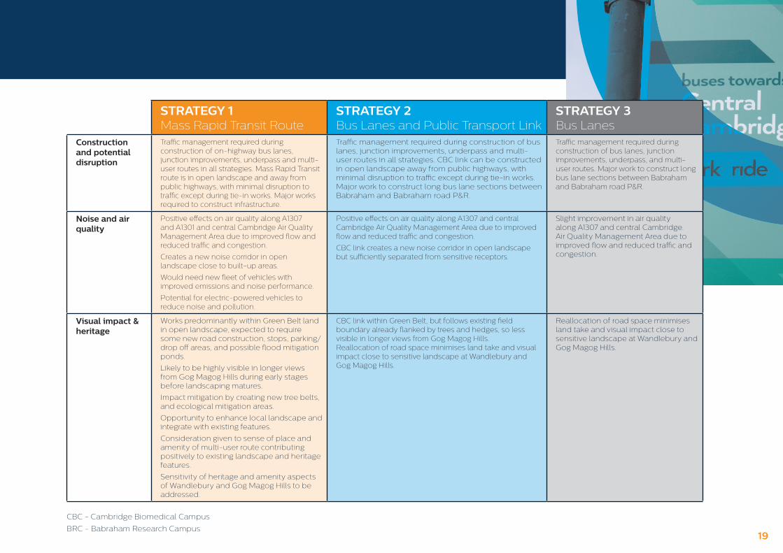
Construction and potential disruption
Traffic management required during construction of on-highway bus lanes, junction improvements, underpass and multi-user routes in all strategies. Mass Rapid Transit route is in open landscape and away from public highways, with minimal disruption to traffic except during tie-in works. Major works required to construct infrastructure.
Traffic management required during construction of bus lanes, junction improvements, underpass and multi-user routes in all strategies. CBC link can be constructed in open landscape away from public highways, with minimal disruption to traffic except during tie-in works. Major work to construct long bus lane sections between Babraham and Babraham road P&R.
Traffic management required during construction of bus lanes, junction improvements, underpass, and multi-user routes. Major work to construct long bus lane sections between Babraham and Babraham road P&R.
Noise and air quality
Positive effects on air quality along A1307 and A1301 and central Cambridge Air Quality Management Area due to improved flow and reduced traffic and congestion.
Creates a new noise corridor in open landscape close to built-up areas.
Would need new fleet of vehicles with improved emissions and noise performance.
Potential for electric-powered vehicles to reduce noise and pollution.
Positive effects on air quality along A1307 and central Cambridge Air Quality Management Area due to improved flow and reduced traffic and congestion.
CBC link creates a new noise corridor in open landscape but sufficiently separated from sensitive receptors.
Slight improvement in air quality along A1307 and central Cambridge. Air Quality Management Area due to improved flow and reduced traffic and congestion.
Visual impact & heritage
Works predominantly within Green Belt land in open landscape, expected to require some new road construction, stops, parking/drop off areas, and possible flood mitigation ponds.
Likely to be highly visible in longer views from Gog Magog Hills during early stages before landscaping matures.
Impact mitigation by creating new tree belts, and ecological mitigation areas.
Opportunity to enhance local landscape and integrate with existing features.
Consideration given to sense of place and amenity of multi-user route contributing positively to existing landscape and heritage features.
Sensitivity of heritage and amenity aspects of Wandlebury and Gog Magog Hills to be addressed.
CBC link within Green Belt, but follows existing field boundary already flanked by trees and hedges, so less visible in longer views from Gog Magog Hills.Reallocation of road space minimises land take and visual impact close to sensitive landscape at Wandlebury and Gog Magog Hills.
Reallocation of road space minimises land take and visual impact close to sensitive landscape at Wandlebury and Gog Magog Hills.
CBC - Cambridge Biomedical Campus
BRC - Babraham Research Campus19

Our proposal forms part of the Greater Cambridge Partnership’s wider strategy working with partners to create better and greener transport networks. The following schemes, which do not form part of this consultation, are closely linked to the Cambridge South East Transport Study.
City Access
The City Access project aims to improve travel within Cambridge by tackling congestion and significantly improving public transport, cycling and walking trips, as well as air quality. It looks to achieve a reduction in peak-time traffic levels in Cambridge by 10-15% below 2011 levels by 2031 and, in doing so, would improve the flow of bus services in the centre.
See more information on the City Access project at: www.greatercambridge.org.uk/city-access
Cambridge Biomedical Campus
Currently 17,250 people are working at the Cambridge Biomedical Campus, but with the opening of new buildings and further growth, this number could rise to 28,000 by 2031. A transport study has now been commissioned to masterplan the future transport needs of the Campus to ensure efficient and convenient access for patients, visitors and staff. Our proposals would improve access to the hospital and Biomedical Campus by public transport.
Cambridge South Station
This new railway station would be located close to the Cambridge Biomedical Campus and Addenbrooke’s Hospital. The project is in its early stages and funding towards a feasibility and business case has been granted. Strategies 1 and 2 would connect to a Cambridge South Station.
Cambridge Greenways
The Cambridge Greenways project aims to establish a high-quality network of 12 separate ways into Cambridge from surrounding towns and villages. If established, these routes would primarily be designed for people to cycle to work and school, with additional benefits for pedestrians, equestrians and for leisure.
The Cambridge South East Transport Study would be a key link in the Greenways network, by creating the Linton Greenway. More information on Greenways can be viewed at: www.greatercambridge.org.uk/greenways
A CONNECTED TRANSPORT NETWORK
20

A1307 Dualling
Upgrading the A1307 to a dual carriageway between Haverhill and the A11 is a scheme being promoted by Suffolk Chamber of Commerce in Haverhill and District through the A1307 Strategy Board, and includes: businesses; the county, borough, district and town councils; and New Anglia and GCGP LEPs. Some early feasibility work has been jointly commissioned and supported by Suffolk and Cambridgeshire County Councils and the Greater Cambridge Partnership.
A505
The A505 is one of the busiest roads in Cambridgeshire and is identified in the County Council’s Long-Term Transport Strategy as a route where more detailed consideration of the issues raised by traffic growth and route choices is needed. The Cambridgeshire and Peterborough Combined Authority has announced funding for a study of the A505 in Cambridgeshire to identify options to address future transport demand.
Cambridgeshire Autonomous Metro
Strategy 1 proposes a Mass Rapid Transit route between the A11 and the Cambridge Biomedical Campus. The details and operation of this route will be the subject of further consideration and consultation. The Cambridgeshire & Peterborough Combined Authority had announced intentions to create a Cambridgeshire Autonomous Metro (CAM) using advanced tram-like vehicles that do not require rails.
Strategy 1 would be based on this mode of operation, subject to further development work and preparation of a business case, and be an extension of CAM to the A11. The network could eventually extend to the market towns surrounding Cambridge, including Haverhill.
An initial service operating in 2021 between the Cambridge Biomedical Campus and Cambridge Station could be extended to the A11 in 2022, with a strategic Park & Ride site close to the A11 and A505 attracting car users to use public transport. Stops at Sawston, Stapleford and Great Shelford would provide convenient, fast access to Cambridge.
Rural Travel Hub
Rural Travel Hubs are bespoke rural transport interchanges to connect residents in South Cambridgeshire with public transport and cycling/walking routes. Key features include close proximity to a rail or bus route, car parking, covered cycle parking and bus shelters with real-time bus information. The GCP is currently investigating the feasibility for piloting Rural Travel Hubs in Sawston, Whittlesford and Oakington. More information is available at: www.greatercambridge.org.uk/rural-travel-hubs
21

WE WELCOME YOUR VIEWS
Have your say between Friday 9 February 2018 and Tuesday 3 April 2018 There are a number of ways to respond to the consultation:
Complete the paper questionnaire and return by Freepost or at a public event
Fill out the online version of the questionnaire at www.greatercambridge.org.uk/ CambridgeSouthEastConsultation
01223 699906
Greater Cambridge Partnership, SH1317, Shire Hall, Cambridge CB3 0AP
@GreaterCambs #CambridgeSE
Facebook.com/GreaterCam
More information including detailed background documents can be found online at: www.greatercambridge.org.uk/CambridgeSouthEast
If you would like a copy of this leaflet in large print, braille, audio tape or in another language please call 01223 699906.
Join us to find out more at a public exhibition:
LOCATION DATE TIME ADDRESS
Linton Monday
26 February 16.00 – 19.00
Linton Village Hall, Coles Lane, CB21 4JS
Babraham Road Park & Ride
Wednesday 28 February
8.00 – 9.30 Babraham Road, CB22 3AB
Stapleford Wednesday
7 March16.00 – 19.00
Stapleford Pavilion, Gog Magog Way, CB22 5BQ
HaverhillSaturday 10 March
9.30 – 12.00Tesco Superstore, Cangle Road, CB9 0BQ
Great AbingtonTuesday 13 March
16.00 – 19.00The Abington Institute, 66 High Street, CB21 6AE
SawstonWednesday
14 March16.00 – 19.00
Sawston Village College, Henry Morris Hall, New Road, CB22 3BP
Cambridge Thursday 15 March
16.00 – 19.00St John the Evangelist, Hills Road, CB1 7TP
Check out our website for further event details: www.greatercambridge.org.uk
22

JULY 2018 GCP Executive Board decision on preferred
strategy and works to take forward
AUTUMN 2018 Planning Applicationsubmitted for Phase 1
elements
NEXT STEPS
The consultation will close at 23.59 on Tuesday 3 April. All responses will be collated by Cambridgeshire County Council’s Research Team. Once this work is completed, responses* will be published at:www.greatercambridge.org.uk *Responses from private individuals will be anonymised.
These responses will also inform further technical work on the strategies.
In summer 2018, taking all of the supporting information and consultation responses into account, the Combined Authority and GCP Executive Board will consider how to proceed with the project. They will decide if the phase 1 proposals presented can be developed further for implementation and choose a preferred strategy for phase 2.
We will then consult with you again on the details of the preferred strategy, should any of them be taken forward.
2020Completion of Phase 1 works
2022 TO 2025 Completion of Phase 2 works depending on strategy and consultation
LOCATION DATE TIME ADDRESS
Linton Monday
26 February 16.00 – 19.00
Linton Village Hall, Coles Lane, CB21 4JS
Babraham Road Park & Ride
Wednesday 28 February
8.00 – 9.30 Babraham Road, CB22 3AB
Stapleford Wednesday
7 March16.00 – 19.00
Stapleford Pavilion, Gog Magog Way, CB22 5BQ
HaverhillSaturday 10 March
9.30 – 12.00Tesco Superstore, Cangle Road, CB9 0BQ
Great AbingtonTuesday 13 March
16.00 – 19.00The Abington Institute, 66 High Street, CB21 6AE
SawstonWednesday
14 March16.00 – 19.00
Sawston Village College, Henry Morris Hall, New Road, CB22 3BP
Cambridge Thursday 15 March
16.00 – 19.00St John the Evangelist, Hills Road, CB1 7TP
Please note, timescales are indicative, subject to change and dependent on approvals.
23

www.greatercambridge.org.uk/CambridgeSouthEastConsultation