can high resolution climate simulations with the community ... · offer a new perspective on 21st...
TRANSCRIPT

Cécile Hannay, Julio Bacmeister, Rich Neale, John Truesdale, Kevin Reed, and Andrew Gettelman.
National Center for Atmospheric Research, Boulder
19th CESM workshop, June 16-20, 2014, Breckenridge.
Can high resolution climate simulations with the Community Atmospheric Model (CAM)
offer a new perspective on 21st century scenarios ?

Motivation
Common wisdom “The expectation is that increasing spatial resolution will generally cause the simulation to improve because of a more accurate topography, and a better large-scale circulation”
1° 0.25°
What does the high resolution buy us ? What is the impact for future projections ?
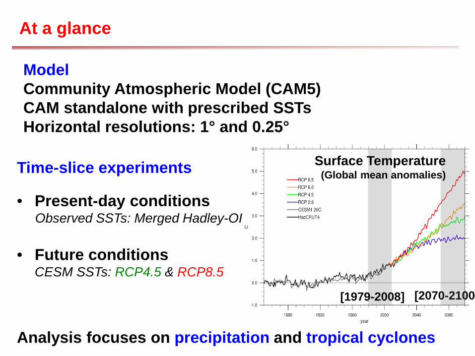
At a glance
Analysis focuses on precipitation and tropical cyclones
[2070-2100] [1979-2008]
Surface Temperature (Global mean anomalies) Time-slice experiments
• Present-day conditions Observed SSTs: Merged Hadley-OI • Future conditions
CESM SSTs: RCP4.5 & RCP8.5
Model Community Atmospheric Model (CAM5) CAM standalone with prescribed SSTs Horizontal resolutions: 1° and 0.25°

Precipitation, JJA
Exacerbated double ITCZ
Increased wet bias in northern ITCZ
Dry bias over Micronesia
Increased precipitation over Africa and South America
Observations: TRMM CAM5: 1 degree
CAM5: 0.25 degree

Asian Monsoon, JJA
TRMM
CAM5 (1°)
CAM5 (0.25°)
Precipitation (color). Topography (contour line = 500m level)

Asian Monsoon, JJA
ERA-Interim
CAM5 (1°)
CAM5 (0.25°)
Red vector: Winds at 850 mb; Contour: Wind divergence
Wind 10 m/s
Convergence
Divergence
Air rises more rain
Subsidence less rain

Seasonal pattern High frequency data (daily)
• Seasonal pattern of precipitation Precipitation frequency
Precipitation intensity
Precipitation frequency (%)
Precipitation intensity (mm/day)
• How often does it rain ?
• How hard does it rain?
Dai et al. (2007)
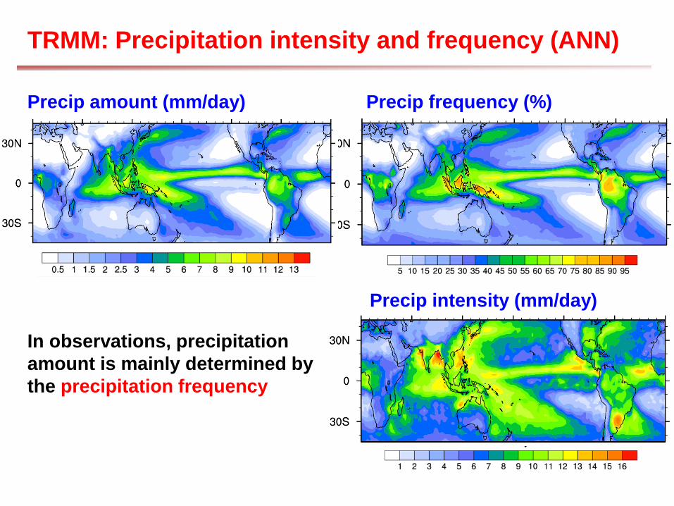
TRMM: Precipitation intensity and frequency (ANN)
Precip amount (mm/day) Precip frequency (%)
Precip intensity (mm/day)
In observations, precipitation amount is mainly determined by the precipitation frequency

Intensity and frequency: CAM (1°) versus obs
Cam rains too often
CAM (1°) => rains too often
CAM (1°) but not hard enough
TRMM: Precip frequency (%)
TRMM: Precip intensity (mm/day)

Intensity and frequency: CAM (025°) vs obs
Cam rains too often
CAM (0.25°) => improved frequency
CAM (0.25°) => mixed result
TRMM: Precip frequency (%)
TRMM: Precip intensity (mm/day)
Problem persists at higher resolution (despite some improvements) !
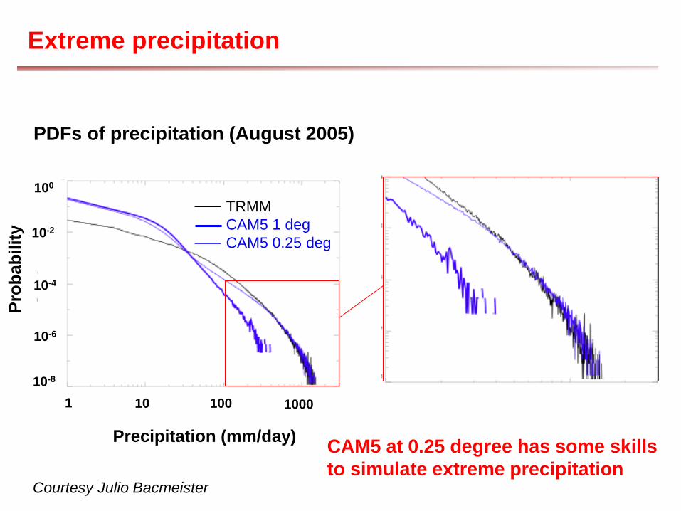
Extreme precipitation
Courtesy Julio Bacmeister
PDFs of precipitation (August 2005)
Precipitation (mm/day)
10 100 1000
Prob
abili
ty
1 10-8
10-6
10-4
10-2
100 TRMM CAM5 1 deg CAM5 0.25 deg
CAM5 at 0.25 degree has some skills to simulate extreme precipitation
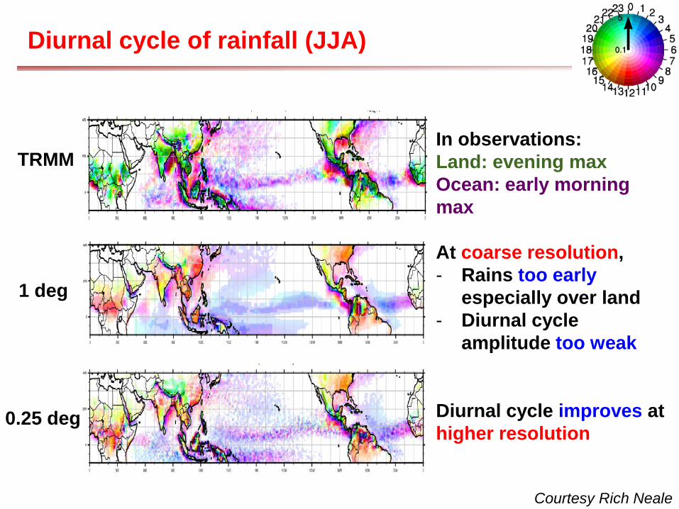
Diurnal cycle of rainfall (JJA)
Courtesy Rich Neale
TRMM In observations: Land: evening max Ocean: early morning max
At coarse resolution, - Rains too early
especially over land - Diurnal cycle
amplitude too weak
Diurnal cycle improves at higher resolution
1 deg
0.25 deg

Diurnal cycle of rainfall (JJA)
Courtesy Rich Neale
TRMM 0.25o (2001- 2010)
CAM5 1o (2001- 2010)
CAM5: 0.25o (1996- 2005)
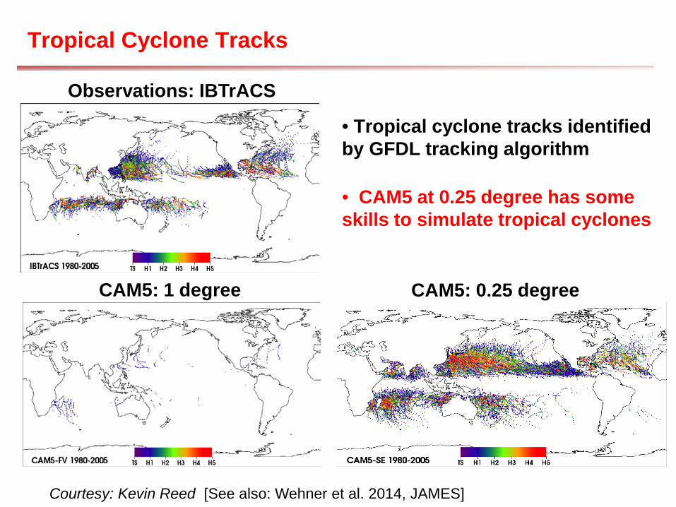
Tropical Cyclone Tracks
•
Courtesy: Kevin Reed [See also: Wehner et al. 2014, JAMES]
• Tropical cyclone tracks identified by GFDL tracking algorithm
Observations: IBTrACS
CAM5: 1 degree CAM5: 0.25 degree
• CAM5 at 0.25 degree has some skills to simulate tropical cyclones

Storm Count: Tropical Storm, Hurricane, Major Hurricane.
Observations: IBTrACS
CAM5: 0.25 degree
Global - Obs - CAM5
West Pacific - Obs - CAM5
North Atlantic - Obs - CAM5
East Pacific - Obs - CAM5
Courtesy: Kevin Reed [See also: Wehner et al. 2014, JAMES]
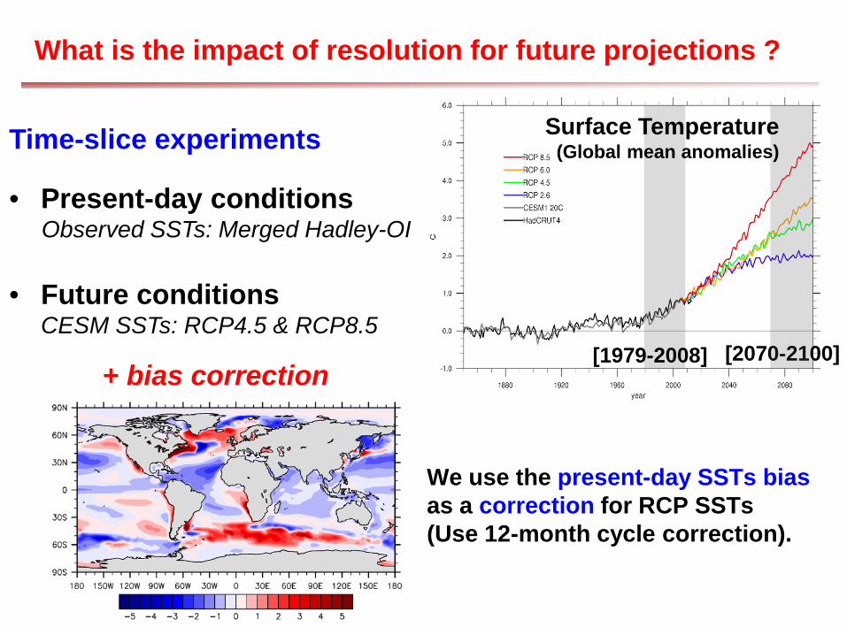
What is the impact of resolution for future projections ?
[2070-2100] [1979-2008]
Surface Temperature (Global mean anomalies) Time-slice experiments
• Present-day conditions Observed SSTs: Merged Hadley-OI • Future conditions
CESM SSTs: RCP4.5 & RCP8.5
We use the present-day SSTs bias as a correction for RCP SSTs (Use 12-month cycle correction).
+ bias correction
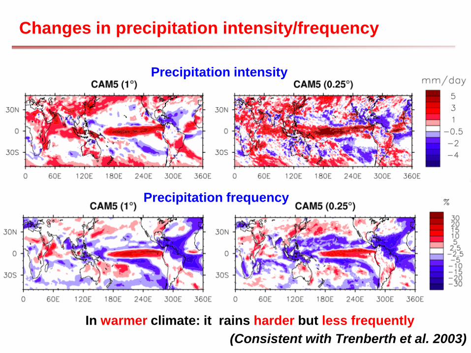
Changes in precipitation intensity/frequency
Precipitation frequency
(Consistent with Trenberth et al. 2003)
In warmer climate: it rains harder but less frequently
Precipitation intensity
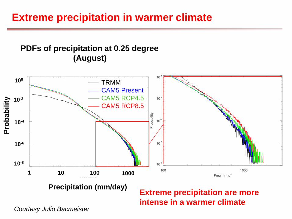
Extreme precipitation in warmer climate
Courtesy Julio Bacmeister
PDFs of precipitation at 0.25 degree (August)
Precipitation (mm/day)
10 100
Prob
abili
ty
1 10-8
10-6
10-4
10-2
100 TRMM CAM5 Present CAM5 RCP4.5 CAM5 RCP8.5
1000
Extreme precipitation are more intense in a warmer climate

Tropical Cyclone count and intensity in warmer climate
•
Courtesy: Kevin Reed
Storm Count Maximum Wind Speed
But the most intense storms become more intense.
In warmer climate: number of tropical cyclones decreases

Conclusions
Mean climate: - Mean precipitation bias is not much improved at higher resolution. - Some biases even get worse (dry Micronesia bias, double ITCZ…) Daily data: - In CAM5: rains too often but not hard enough. Despite some improvements, the problem persists at higher resolution.
Diurnal cycle At coarse resolution, CAM fails to reproduce observed diurnal cycle - Rains too early especially over land
Diurnal cycle amplitude too weak - Diurnal cycle improves at higher resolution but some bias remains
Extreme events CAM at 0.25 degree has some skills to reproduce extreme precipitation and tropical cyclones

Conclusions
In a warmer climate: - It rains harder but less frequently
- Extreme precipitation are more intense
- The number of tropical cyclones decreases
but the most intense storms become more intense.

Thanks !