can we use a crisis mapping platform to help tame the wicked problem of participation?
TRANSCRIPT
Can We Use a Crisis Mapping Platform to Help Tame the Wicked Problem of Participation?
Ana Brandusescu, Renée Sieber, Sylvie JochemsAAG Annual Meeting, Tampa, FL, 2014
1

Connect community development to
community informatics
Connect existing technology mediums
to a new technology platform
Independent public participation
(aside from events and workshops)
Create a dialogue
2
Wicked Problem Context

Background

Haiti Earthquake

Connect: crisis mapping, community
development, community informatics
PPGIS processes vs geoweb
mapping applications
Traditional vs new methodologies
Not new: ICTs do not guarantee
community support; lack of
participation
2

Methodology
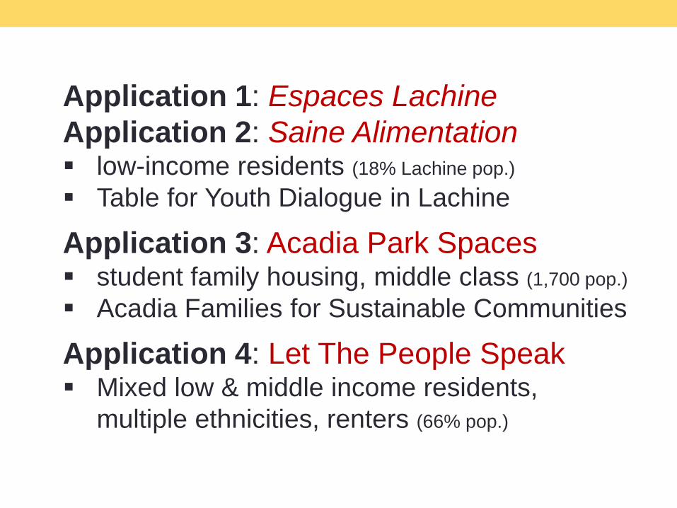
Application 1: Espaces Lachine
Application 2: Saine Alimentation low-income residents (18% Lachine pop.)
Table for Youth Dialogue in Lachine
Application 3: Acadia Park Spaces student family housing, middle class (1,700 pop.)
Acadia Families for Sustainable Communities
Application 4: Let The People Speak Mixed low & middle income residents,
multiple ethnicities, renters (66% pop.)
3

4

4
4
4

5 Findings

Temporality: Is a Community Issue Too Acute?
Grandview-Woodland application
never launched
Reliable methods of community
practices already exist
New technology = dilution of
community efforts / message fatigue

Or a Good Match?
Acadia Park application launched
Imminent rezoning (~800 residents
relocated)
Demand for a mapping-based method
Safe environment for contributions
Open to new technology and
communication channels
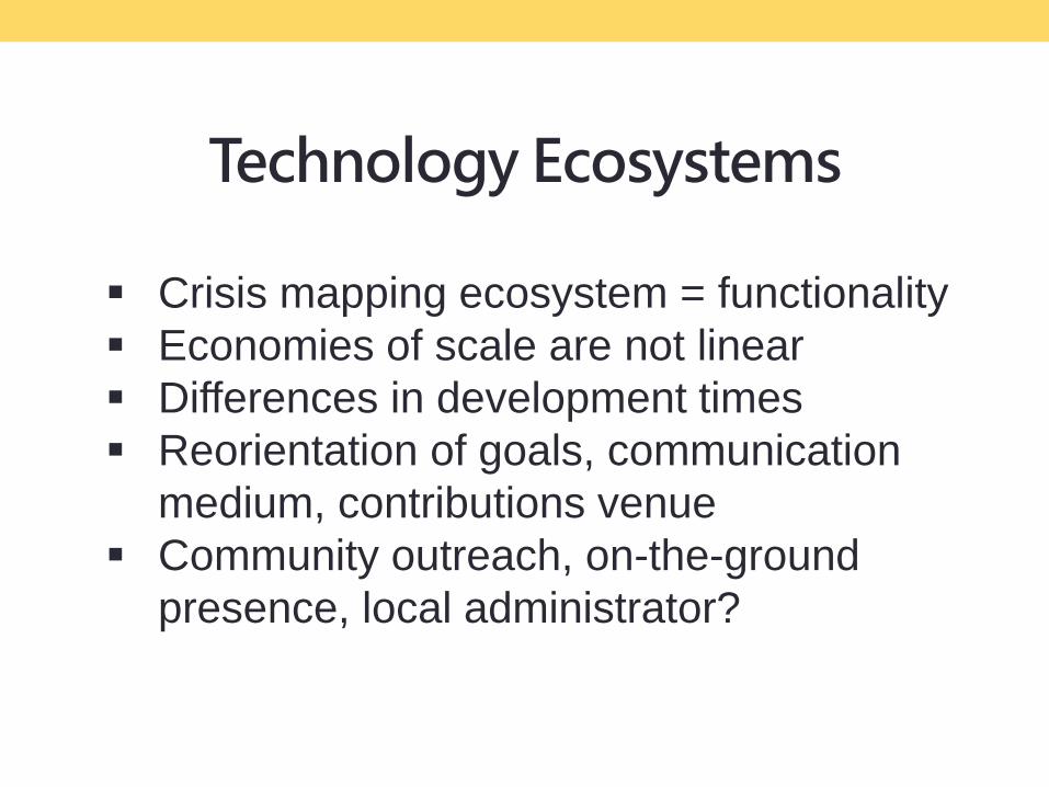
Technology Ecosystems
Crisis mapping ecosystem = functionality
Economies of scale are not linear
Differences in development times
Reorientation of goals, communication
medium, contributions venue
Community outreach, on-the-ground
presence, local administrator?

Motivation to Implement
Civic activism and pride of place
Motivations vary and change
Lachine: no identifiable urgency,
unclear goals
Grandview-Woodland: urgency,
existing technology ecosystem
Acadia Park: urgency, a mapping
demand

Missing Link: Contribution and Action
Crisis mapping presumes:
action = reporting
A sense of response immediacy, yet
no guarantee of action
Example: playground safety in
Lachine; me? the Table? City hall?
Atypical Small Data in a Big Data World
Atypical small data: unstructured (SMSs,
Tweets), expert and non-expert process
1. Volume substituted for data accuracy
2. Community voice vs data accuracy

Conclusions
Mixed findings
Temporality: different acute community
issues
Missing link: contribution and action
Motivation to implement varies and
changes
Differing technology ecosystems
Atypical small data is challenging

Can we use a crisis mapping platform to tame the wicked problem of
participation?
Not really.


ReferencesAbraham, R. (2007). Mobile phones and economic development.
Aker, J., & Mbiti, I. (2010). Mobile phones and economic development in Africa.
Budhathoki, N.R. (2010). Participants ‘motivations to contribute geographic information
in an online community.
Coleman, D.J., Georgiadou, Y., & Labonte, J. (2009). VGI: the nature and motivation of
produsers.
Donner, J. (2008). Research approaches to mobile use in the developing world.
Elwood, S., & Ghose, R. (2004). PPGIS in community development planning.
Girard, B., & O Siochru, S. (2006). (Eds.). Communicating in the information society.
Goodchild, M. F., & Li, L. (2012). Assuring the quality of VGI.
Goodchild, M. F. (2013). The quality of big (geo) data.
Haklay, M. (2010). How good is volunteered geographical information?
Hardey, M. (2007). The city in the age of web 2.0 a new synergistic relationship
between place and people.
Horst, H., & Miller, D. (2006). The cell phone: an anthropology of communication.
Katz, J.E. (2011). Mobile communication: dimensions of social policy.
Patnaik, S., Brunskill, E., & Thies, W. (2009, April). Evaluating the accuracy of data
collection on mobile phones: a study of forms, SMS, and voice.
Sieber, R.E. (2006). Public Participation Geographic Information Systems.
Yzer, M.C., & Southwell, B.G. (2008). New communication technologies, old questions.
Zook, M, Graham, M., Shelton, T., & Gorman, S. (2010). VGI and crowdsourcing
disaster relief.
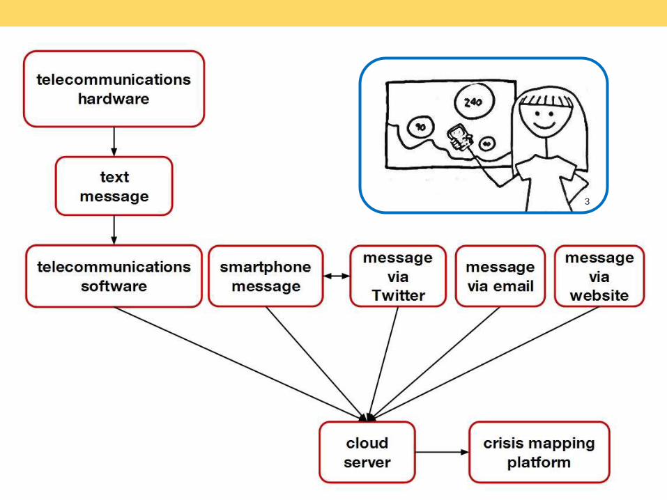
[1] Cartoon drawn and digitized by Ana Brandusescu.
http://prezi.com/user/anabrandusescu/
[2] Crowdsourcing logo. http://blog.hbs.edu/hbsinov8/?p=1652
[3] Cartoon drawn and digitized by Ana Brandusescu.
http://prezi.com/user/anabrandusescu/
[4] Acadia Park Spaces logo designed by Lisa Chen-Wing.
https://acadiaparkspaces.crowdmap.com
Image References