americancanals · 3 canal, with which it connects in huddersfield. this inland waterway has locks...
TRANSCRIPT

From the President
by David G. Barber
Recently I attended a tour by the
Pennsylvania Canal Society of the
lower end of the Delaware Division
Canal. This sixty-mile long, tow-
path-era canal runs south to north
along the west side of the Delaware
River from tidewater at Bristol, PA,
to the Lehigh River at South
Easton, PA. In its operating era, it
connected the Lehigh Canal to the
Philadelphia area and carried many
tons of anthracite coal to market.
On closing, it was transferred in
two separate periods to the state as
a park. Unfortunately, attitudes in
the 1930s and 1950s resulted in
several compromises of the canal,
particularly at the lower end.
A few years ago, I began to
systematically explore the canal
after having seen some isolated
points in earlier visits. At that time,
the canal had recently been
rewatered throughout its length
except for the southernmost mile
and was the second most visited
state park in Pennsylvania. Those
explorations were interrupted when
the canal was hit by three “100-year
floods” in a three year period. Plans
for more improvements were frozen
as the damage was surveyed three
times, procedures gone through,
and plans made.
On the tour we got to see the
filled in lower mile, for which there
is much pressure to dig it out. There
are many who believe that doing so
would help the viability of the
Bristol business district which is
adjacent. We also got to see
Bristol’s Snyder Elementary
School, which is the only building
now built across the line of the
canal. This school was built in
the early 1950s and is now obso-
lete. The interesting sight there
was the new school that is being
built next door and off of the ca-
nal line to replace the 1950s
building. Soon, there will be no
buildings compromising the ca-
nal line.
Of major interest were the
reports of contracts being let and
bid for repair of the flood
damage to the northern end of
the canal. The repairs include
measures to reduce the damage
of future floods. Also, other
measures are being considered to
replace some stop gates and
provide other measures to allow
flood waters to leave the canal
without damaging it. There is
even one project underway to
(continued on page twelve)
Vol. XXXVII, No. 3 Dedicated to Historic Canal Research, Preservation, and Parks Summer 2008
CSNJ Director Bob Angland studies the tunnel portal, 2005. Photo by Linda J. Barth
AmericanCanals Bulletin of the American Canal Society
BY CANAL BOAT, CABLE
TRAM, AND STEAM TRAIN
THROUGH ENGLAND AND
NORTHERN WALES
(Part 6 of a series)
by Bruce J. Russell
Following our visit to the
Anderton Boat Lift, which has
been fully restored and able to
raise vessels from the Weaver
River to the Trent & Mersey
Canal, we continued to the town
of Ashton. Here we would have
the opportunity to visit the
Huddersfield Narrow Canal, a 19-
mile-long waterway that crosses
the Pennine Mountains using
seventy-four locks, all of seven-
foot width.
It’s called the Huddersfield
Narrow Canal to distinguish it
from the Huddersfield Broad
(continued on page three)
2
American Canals
BULLETIN OF THE
AMERICAN CANAL SOCIETY
Senior Editor: Linda J. Barth
Contributing Editors: David G. Barber,
Paul Bartczak, Dan McCain, Bruce J.
Russell
www.americancanals.org For memberships, subscriptions, change
of address, and other business matters:
c/o Charles W. Derr, 117 Main Street,
Freemansburg, Pennsylvania 18017;
For CANAL CALENDAR items and
for news of local, state, and regional
canal societies: c/o Linda J. Barth, 214
North Bridge Street, Somerville, NJ
08876; 908-722-7428; [email protected]
The objectives of the American Canal
Society are to encourage the preserva-
tion, restoration, interpretation, and use
of the historical navigational canals of
the Americas; to save threatened canals;
and to provide an exchange of canal
information. Manuscripts and other
correspondence consistent with these
objectives are welcome.
An annual subscription to American
Canals is automatic with ACS member-
ship. Annual dues: $20. Single copies,
$3. Four issues per year. Copyright
©2008 by the American Canal Society.
All rights reserved. Printed in the United
States of America.
ISSN 0740-588X.
Other Publications: The Best from
American Canals; American Canal
Guides, William E. Trout III, editor and
publisher
DEADLINE: Material for our next issue
must be on the editor’s desk no later than
September 1, 2008. Send to Linda Barth,
214 N. Bridge St., Somerville, NJ 08876;
Material submitted to AMERICAN
CANALS for publication should
be typed and double-spaced or
sent by email in
WORD format. You may send actual
photographs (which will be scanned
and returned), or digital versions may
be emailed or sent on a CD.
Officers President: David G. Barber, 16
Ballou Road, Hopedale, MA 01747;
508-478-4918; Director, Chair,
American Canal Survey
Committee, [email protected]
Vice President: William Gerber, 16
Princess Ave., N. Chelmsford, MA
01863; 978-251-4971(h) Director;
bill_gerber @bostonbbs.org
Vice President: Michael E.
Morthorst, 6914 Ohio Ave.,
Cincinnati, OH, 45236; 513-791-
6481 Director; [email protected]
Secretary: David M. Johnson, 9211
Wadsworth Drive, Bethesda, MD
20817; 301-530-7473; Director;
Member Canal Liaison Committee
Treasurer: Charles Derr, 117 Main
Street, Freemansburg, PA 18017;
Director; Member Canal Egr,
Operations & Maintenance Comm,
610-691-0956; [email protected]
Directors:
Paul Bartczak, 9954 New Oregon Rd,
Eden, NY 14057; 716-992-9069;
Linda J. Barth, 214 N. Bridge St.,
Somerville, NJ 08876; 908-722-
7428; Editor, American Canals;
Robert H. Barth, 214 N. Bridge St.,
Somerville, NJ 08876; 908-722-
7428; Chairman ACS Sales Commit-
tee; [email protected]
Carroll Gantz, 817 Treeloft Trace,
Seabrook Island, SC 29455-6116;
843-768-3780; Chairman, Canal Boat
Committee; [email protected]
Keith W. Kroon, 2240 Ridgeway
Ave., Rochester, NY 14626; 716-225
-0688; [email protected]
John M. Lamb, 1109 Garfield Street,
Lockport, IL 60441; 815-536-7316;
Canal Engineering, Maintenance &
Operations Committee.
Dan McCain, 3198 North, 700 West,
Delphi, IN 46923; 765-564-6297;
Lance Metz, National Canal
Museum, 30 Center Square, Easton,
PA 18042; 610-250-6774;
Robert Schmidt, 5909 Chase Creek
Court, Fort Wayne, IN 46804;
260-432-0279; Chairman Nominating
Committee, Member Canal Engineer-
ing, Maintenance & Operations
Committee; [email protected]
Robert Sears, 248 Tower Drive,
Toronto, ON M1R 3R1, Canada;
Canada; [email protected]
416-285-7254
Roger Squires, 46 Elephant Lane,
Rotherhithe, London SE16 4JD
England; 020 7232 0987;
Roberta Styran, P.O. Box 304,
Thorold, Ontario, L2V 3Z3 Canada;
Canada; [email protected]
Nancy Trout, 35 Towana Road,
Richmond VA 23226; 804-288-1334;
William Trout III, 35 Towana Road,
Richmond, VA 23226; 804-288-1334;
Larry Turner, 15091 Portage Street,
Lot # 34, Doylestown, Oh 44230; 330-
658-8344; [email protected];
Terry K. Woods, 6939 Eastham
Circle, Canton OH 44708; 330-832-
4621; Chair, Publications, Publicity
Committee, Parks Committee,
Member Canal Archaeology
Committee, Acting Chairman, Canal
Boat Committee, Canal Engineering,
Maintenance & Operations
Committee; [email protected]
Directors Emeritus Denver Walton, 968 Chapel Road,
Monaca, PA 15061; 724-774-8129. Committees: ACS Sales, Robert H. Barth, chair Canal Archaeology, Mark Newell, Chair, Georgia Archaeological Inst, PO Box 984, Augusta, GA 30901 Canal Boat, Carroll Gantz, Chairman, Canal Boat Committee Canal Engineering, Maintenance, & Operations, Terry Woods, acting chair Canal Parks, Terry K. Woods, chair Historic American Canals Survey, David G. Barber, chair
3
Canal, with which it connects in
Huddersfield. This inland
waterway has locks of fourteen-
foot width, capable of handling
two seven-foot vessels together, or
one larger one. When we arrived
at Ashton, the western terminus of
the Huddersfield Narrow Canal,
we were met by representatives of
the Huddersfield Canal Society.
These knowledgeable guides
gave us a background on this
unique canal that only returned to
active usage in 2002, after years
of reconstruction. The year 2000
map of the British canal system
shows this canal as still closed,
but it certainly appears as open
and navigable on more recent
ones. (As stated previously,
more and more of Britain’s ca-
nals are being brought back into
active usage, an effort spear-
headed by the Waterways Re-
covery Group. The ultimate goal
is to get as much canal mileage
into service as possible, allowing
for more and longer journeys for
those on canal holidays.)
We began our exploration of
this mountain climbing water-
way at Ashton, where it connects
with the Peak Forest Canal. We
saw places where, until restoration
work began over twenty years
ago, the canal was nothing but a
dry ditch, filled with garbage,
junked cars, and other debris. But
now it’s watered and used by nar-
row boats.
Clearing out abandoned canal
beds is a monumental task, but
can be accomplished by those who
consider it a labor of love. While
in the United States certain short
segments of canals are sometimes
restored and rewatered, in Britain
this simply won’t do. Instead, the
objective is to get the entire canal
back in service. Funding for this
comes from the Inland Waterways
Association, local government,
and private donations. Most of the
physical labor is done by
volunteers who simply love their
canals.
The Huddersfield Narrow Canal
was constructed about 1805 dur-
ing the great era of canal build-
ing. It’s situated in the area be-
tween Manchester and Shef-
field, two industrial cities, sepa-
rated by the Pennine Moun-
tains, which, compared to the
mountains of Europe, are very
low, almost hills. Manchester and
Sheffield were, at the time,
becoming highly industrialized,
and a means of transport was
needed to carry goods from one to
the other. Railroads hadn’t yet
been invented, but canal
technology had been perfected.
Getting a canal up and over the
Pennines constituted a real
challenge for the early 19th-
century engineers, but they
eventually came up with this
mountain-climbing waterway with
a mile-long tunnel at the summit
level. No wonder it later acquired
the name, “Everest of the Canals”!
One reason that canal
building was considered vital
The Huddersfield Narrow Canal at Stalybridge. Photo by Linda J. Barth
4
A portion of the Huddersfield Narrow Canal, in Huddersfield, required these support
beams to prevent the stone retaining walls from caving in. Photo by Bruce Russell
during these years was that
England was at war with France,
then ruled by Napoleon.
Maritime battles sometimes made
the coastal shipment of goods
impractical; hence, being able to
move goods inland by means of
artificial waterways was viewed
as an essential component of
national defense, with canals
filling much the same role our
interstate highways do today.
The Huddersfield Narrow Canal
carried large quantities of coal,
iron, lumber, building stone, etc.,
until the 1850s when a parallel
railway was completed. Slowly
the railway began to capture the
business of the canal, and by the
1920s it was a candidate for
closure. But like many obsolete
things in Britain, its death was a
lingering one, and total closure
only took place after the Second
World War. I suspect that a few
canalside industries, perhaps coal
yards, kept it going. It’s also
possible that by then only a
portion of it was in usage. (This
was similar to the situation of the
Delaware & Hudson Canal in
New York State. The main part
was shut down in 1898, but a nine
-mile section from Rondout, the
port of Kingston, to High Falls,
remained functional until 1906,
primarily to serve the ce-
ment industry.
Our bus made a number of
stops where we observed points of
interest. In one place, the canal
passed beneath the business
district of a town in a short tunnel.
During restoration, the dirt and
rubble that had been used to seal it
shut had to be removed, using
picks and shovels as well as
modern machinery. Furthermore,
the canal’s approach to the tunnel
was in a walled passageway, that
had to be extensively stabilized,
using transverse supporting
beams.
All of the towns served by the
canal were once textile
manufacturing centers, and old
mill buildings similar to those in
the historic district of Lowell,
Massachusetts, abound. (In
Clifton, NJ, the Doherty Silk
Mill can be seen from the Gar-
den State Parkway. In Passaic,
the old Botany Mills buildings
stand next to the Dundee Canal.) During the mid-1800s these
mills hummed with activity, and
contributed to Britain’s wealth.
Until the supply from the
American South was disrupted
by the Civil War, much of the
cotton used by the mills of
Ashton and Huddersfield arrived
by sailing ships from the U.S.
After being unloaded at various
ports, the cotton worked its way
inland on canal boats. British
cotton brokers regularly traveled
to South Carolina, Georgia,
Florida, Alabama, Mississippi,
and Texas to make deals with
plantation owners. After 1861,
the US Navy blockaded southern
ports such as Charleston and
New Orleans, and this trade
ceased. Egypt and India then
became the primary cotton
sources. The densest network of
canals in England was in the in-
dustrial Midlands, and not in the
London region, although canals
existed there. The “early bird”
portion of the tour, in which I did
not participate, visited the Black
Country Museum near Birming-
ham; this museum provides an
excellent overview of Britain’s
industrialization, starting in the
late 1700s. The role of canals as
forerunners to railways is
emphasized.
The most awe-inspiring feature
of the Huddersfield Narrow Canal
is its summit level tunnel at
Standedge. Over a mile in length,
it was a genuine triumph of early
19th-century engineering. Black
powder was used to blast through
solid rock, with the rate of
progress about 50 feet per day.
Many of the laborers were Irish
immigrants, and some lost their
lives in accidents. Due to the
tunnel’s seven-foot width, boats
could not pass inside; for one
hour, vessels were permitted to
travel in one direction; then traffic
flowed in the opposite direction
for the next hour. Signalmen at
both portals coordinated the

5
movement, possibly using lighted
torches. During the 1830s a steady
progression of narrow boats, all
horse drawn, traveled over this
waterway.
The Standedge Tunnel did not
have a towpath for the horses, a
feature incorporated in later canal
tunnels. Instead, the animals were
walked over the top of the tunnel,
using a special path. To get the
vessels through, men would lie on
their backs on the tops of the boats
and push them through, using
their legs and feet to “walk” along
the upper arch of the tunnel. This
operat ion was known as
“legging,” and there were actually
professional leggers who could
move a boat at five miles per hour
through a tunnel. This was done
entirely in darkness, with the
men’s feet feeling their way along
the arch, that, like the rest of the
bore, was lined with brick.
Our group stopped at one end
of this 200-year-old canal tunnel
to admire it. We were told that a
railway tunnel, built in the 1860s,
passes beneath the Standedge at a
point near this western portal. A
metal gate was in place to prevent
unauthorized access.
The Huddersfield Canal
Society remains very active and
boasts hundreds of members.
They publish a quarterly maga-
zine called Pennine Link, which
gives historical and other useful
information about the incredible
“Everest of the Canals.” Because
this canal contains seventy-four
locks over its nineteen miles, a
journey from Ashton to
Huddersfield takes a minimum
of five days. Nevertheless, as
there are railway “mileage
freaks” whose ambition is to ride
on every stretch of high iron in
the nation, so there are “canal
freaks,” who want to get their
narrowboat over every segment
of the network. When the Hud-
dersfield Canal was restored in
2002, several boaters were al-
ready lined up, waiting to make
the full transit. Perhaps some
day I will return, rent a boat, and
do the trip.
Upon completion of the tour,
we walked along the restored
canal through Huddersfield.
Adjacent to it at one point was a
Tesco Supermarket, and boats
Entrance to the Standedge Tunnel, the highest in Britain. Photo by Bruce Russell.
were moored while their
occupants went shopping.
Perhaps some were provisioning
for a five-day trip down to
Ashton. I spotted one guy, or
bloke, as the Brits say, returning
with several cases of beer.
Obviously, his voyage would be a
boozy one. Believe me, canalling
can be great fun when you’re
among friends, and simply
watching the passing scene.
TO BE CONTINUED
ELEVEN-CANAL
ADVENTURE IN
UPSTATE NEW YORK by S. David Phraner
(This is the first in a series about
this Canal Society of New Jersey
trip.)
Last fall my wife and I took
part in a Canal Society of New
Jersey (CSNJ)-sponsored motor
coach and canal boat excursion in
eastern upstate NY. I counted no
fewer than eleven canals that we
covered, including:
1 7 9 0 s M o h a w k R i v e r
navigation improvements
(rafts & Durham boats)
“Clinton’s Ditch,” the first
Erie Canal, completed in 1825
Improved/Enlarged Erie Canal
of the mid/early-mid 1800s
1917-era NY State Barge
Canal
Original Champlain Canal
(early 1820s)
Improved Champlain Barge
Canal (1917-era)
Glen Falls Feeder Canal navi-
gation (to Champlain Canal)
Black River (towpath) Canal
Forestport Feeder Canal (to
Black River Canal)
Chenango Canal
Delaware & Hudson Canal
This area of travel is roughly
defined on the northeast by Glens
————————————————
6
Falls, on the northwest by
Boonville, on the southwest by
Greene and the southeast by King-
ston. Note that the above named
canals were originally 19th-
century, early towpath (boats
hauled by mules) or later 20th-
century-canals or inland naviga-
tions (tow or tugboats hauling
barges). Each of the above canals
had separate alignments and
terminal points. For example, near
Little Falls, NY, one can see the
original Clinton’s Ditch, the
Improved Erie, and even remnants
of the 1895 canal bypassing the
falls of the Mohawk. All of this
presents a mystifying and impres-
sive array of canal works active
and abandoned, scattered along
parallel alignments and spread
over four centuries. The complex
railroad overlay in this area adds
to the fascination. Of course there
are other feeders that we did not
visit during our four-day
excursion, including the active
Oswego, the Cayuga-Seneca, and
the abandoned Genesee.
The trip ran from Friday,
October 5 to Monday, Oct. 8,
2007, and the weather was
unseasonably warm, with
intermittent rain and clouds. A
prolonged drought was causing
concerns in the North Country
and the Mohawk Valley. This
dry spell necessitated releasing
water from the reservoir system
into the canals and feeders to
keep the navigation flowing on
the main line canal. It was
thought that navigation on the
canal might be curtailed early
this year (2007) as a result.
Because of the drought, Hinck-
ley Reservoir was down almost
30 feet and Delta Lake appeared
to be down 12-15 feet. Some of
these reservoirs are also water
supply for urban areas. This
troubles some of the lake
dwellers as they sacrifice “their”
lake for the sake of the canal
navigation. One must consider
that the building of the canal
justified the lake in the first
instance. I came away with a
renewed and intensif ied
appreciation for the scope and
functions of the New York State
Canal System as navigation, water
supply, and a source of recreation
and economic development. TR,
“by Jove,” had it right in
aggressively supporting the
conversions of the canal system
from a 19th-century mule-
propelled, obsolete waterway into
a modern inland navigation
system.
Our journey began at Ramapo
College in northern New Jersey.
Our tour leaders, CSNJ members
Jakob and Gely Franke, had led us
on a tour of New England canals
about three years ago. That was
their first tour leadership
experience, and they executed tour
guide roles exceptionally then and
now as well. They are both Dutch
(Friesian), naturalized Americans,
so they understand travel, the
importance of detail, dry runs
(three for this trip), and they
exhibit consistently good humor
and patience. Our participants are
also much better than average
senior travelers, since they are
mostly experienced, very fit,
knowledgeable, historians and
intellects.
We motored north on the
Thruway to Kingston and wound
our way via Route 32 down to
Eddyville at the head of
navigation on the Rondout Creek.
Lock #1 on the D&H was a guard
lock into the tidal creek as well as
a lift lock into a large basin. The
basin led into the canal prism (or
what’s left of it), heading
southwest and also provided
access to a weigh lock. A house
has been built on the foundation
of the weigh lock. In its original
state, the weigh lock was covered
by a large barn-like building. The
lock, in remarkably good shape
for its age, is constructed of
limestone blocks. The timber
Lock #1, Delaware & Hudson Canal, Rondout, New York. Photo by Jakob Franke

7
gates are gone and the site is not
restored, but is relatively undis-
turbed. A contemporary seasonal
c.1940 cottage is located on the
site of the original lock tender’s
house. An earlier lock, replaced
when the canal was enlarged in
the 1850s, is almost entirely
obliterated. A large three-story
brick (remember Kingston was a
brick industry town) building
(now housing “The Anchorage”
restaurant) once served as an
administration building for the
D&H Canal. One other dwelling
has survived what was once a
cluster of buildings in the vicinity
of the lock. Recreational boating
and camping facilities occupy the
immediate downstream north bank
area from the lock. While the
D&H Canal was abandoned in
1898, the lower few miles of the
canal between Rosendale and
Eddyville were purchased and
operated by the Cornell steamboat
interests. The cement producers at
Rosendale were not yet ready to
give up on the canal as a means of
delivering their product to market.
Our next stop was on the active
C h a m p l a i n C a n a l , L o c k
#C(hamplain)5 at Schuylerville.
We approached the town along the
river through Mechanicville, a
route that provided us with views
of the old original Champlain
Canal towpath.
Arriving at Lock #5 just north
and west of downtown Schuyler-
ville, we lunched on board the
stern-wheeler MV Caldwell Belle
a. Camden Queen official
#585901, (62’x12.4’x2.8). Her
homeport is Saratoga, though she
operates from Schuylerville’s
Lock 5. Initially, I dismissed this
craft and its operator, Champlain
Canal Tour Boats, as yet another
misguided attempt to recreate the
Mississippi River steamboat era in
Upper New York State. I was
wrong on several counts. First,
this is a genuine stern-wheel
propelled boat (chain and
sprocket diesel reduction [58:1]
direct drive). No prop propelled
draggin’ wheel here. Second, a
glance at the certificate indicated
that the boat was built in West
Bend, Wisconsin, in 1974, for
service on the Mississippi River.
Her later history includes service
on the Ohio (OH), the Kanawha
(WV), and the Archafalaya (LA)
rivers. Third, in hull form, scale,
profile, and proportions, the
Belle approximates a small 19th
century-style workboat on the
western rivers. She draws only
three feet loaded, as the captain
later demonstrated by leaving
the channel and coming
upstream behind an island where
we could observe the bottom of
the Hudson River (at this point
the barge canal and the river are
one) passing below us. Even her
name is authentic. She was
renamed Caldwell Belle in
Louisiana after a southern
notable. Since there was a local
historical figure in the Schuyler-
ville area by the name of
Caldwell, the current owners
decided to keep the name
Caldwell Belle. Finally, the
management purchased a very
attractive steam launch reproduc-
tion (fiberglass hull with diesel
propulsion). Everything else on
this pretty little boat is authentic
in appearance of a late 19th-
century steam launch, including
decorative canopy with awning,
hourglass stern, and peripheral
leather-like seating.
Two school groups on the boat’s
previous voyage were late and
threw off our schedule. They were
just locking through upstream as
we arrived. This fortuitous delay
gave us an opportunity to inspect
the canal works at Lock 5 in
detail. I observed that the
condition of this and other NYS
Canal Corporation locks and
grounds are cons iderably
improved from the last time we
traversed the canal some years
back on Mid-Lakes Navigation’s
Emita II. The canal corporation is
still affiliated with its reluctant
host, the Thruway Authority
(NYTA). I was reminded of that
old army adage, “If it moves,
Guests enjoyed lunch aboard the Caldwell Belle, a stern-wheeler on the Champlain Canal
8
salute it. If it remains still, paint it
OD or white.” In this case,
substitute yellow and blue paint as
the traditional NY State Canal
colors. Lock 5 must take the prize
for the most polished and best
maintained of the fifty-seven
locks on the 524-mile NYS Canal
System. All of the paint looks
glossy fresh. All the brass on the
switchboards and nameplates on
the generators are highly polished
(the lock auxiliary heaters are
DC). All of the locks are
electrically operated, except Lock
#6 on the main line, which is
hydraulic. We were later to
inspect Lock 6 and observe its
operation’s impressive 37’ rise
and 3.5 million gallon release.
We had a delightful buffet lunch
on board as we headed south
through the lock downstream,
before rounding the second island
and departing from the channel, as
I described above. The narration
was plentifully detailed and
informative, and not the usual
tourist claptrap. The Caldwell
Belle is well maintained. I was
impressed with its appearance,
even after a long operating season.
Our tour first went south through
the lock and then returned through
the lock heading upstream past the
Schuylerville dam (and the reason
for the lock). The barge canal
departs from the Hudson for a
short distance to bypass the dam, a
series of mild eddies, and two
abandoned rail bridges.
After completing the first of two
voyages on the canal and
inspecting a large model canal
packet boat built for local display,
we departed Lock 5, heading
north along Route 4, paralleling
the route that we had just taken
via the Caldwell Belle. It
provided us with another view of
the dam and the railroad piers in
midstream.
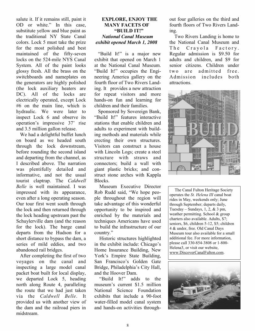
EXPLORE, ENJOY THE
MANY FACETS OF
“BUILD IT!”
National Canal Museum
exhibit opened March 1, 2008
“Build It!” is a major new
exhibit that opened on March 1
at the National Canal Museum.
“Build It!” occupies the Engi-
neering America gallery on the
fourth floor of Two Rivers Land-
ing. It provides a new attraction
for repeat visitors and more
hands-on fun and learning for
children and their families.
Sponsored by Sovereign Bank,
“Build It!” features interactive
stations that enable children and
adults to experiment with build-
ing methods and materials while
erecting their own structures.
Visitors can construct a house
with Lincoln Logs; create a steel
structure with straws and
connectors; build a wall with
giant plastic bricks; and con-
struct stone arches with Kappla
Blocks.
Museum Executive Director
Rob Rudd said, “We hope peo-
ple throughout the region will
take advantage of this wonderful
opportunity to be inspired and
enriched by the materials and
techniques Americans have used
to build the infrastructure of our
country.”
Historic structures highlighted
in the exhibit include: Chicago’s
Home Insurance Building, New
York’s Empire State Building,
San Francisco’s Golden Gate
Bridge, Philadelphia’s City Hall,
and the Hoover Dam.
“Build It!” adds to the
museum’s current $1.5 million
National Science Foundation
exhibits that include a 90-foot
water-filled model canal system
and hands-on activities through-
out four galleries on the third and
fourth floors of Two Rivers Land-
ing.
Two Rivers Landing is home to
the National Canal Museum and
T h e C r a y o l a F a c t o r y .
Regular admission is $9.50 for
adults and children, and $9 for
senior citizens. Children under
t w o a r e a d m i t t e d f r e e .
Admiss ion includes both
attractions.
The Canal Fulton Heritage Society
operates the St. Helena III canal boat
rides in May, weekends only; June
through September; departs daily,
Tuesday – Sundays, 1, 2, & 3 pm,
weather permitting. School & group
charters also available. Adults, $7;
seniors, $6, children 5-12, $5; children
4 & under, free. Old Canal Days
Museum tour also available for a small
additional fee. For more information,
please call 330-854-3808 or 1-800-
Helena3, or visit our website,
www.DiscoverCanalFulton.com.
9
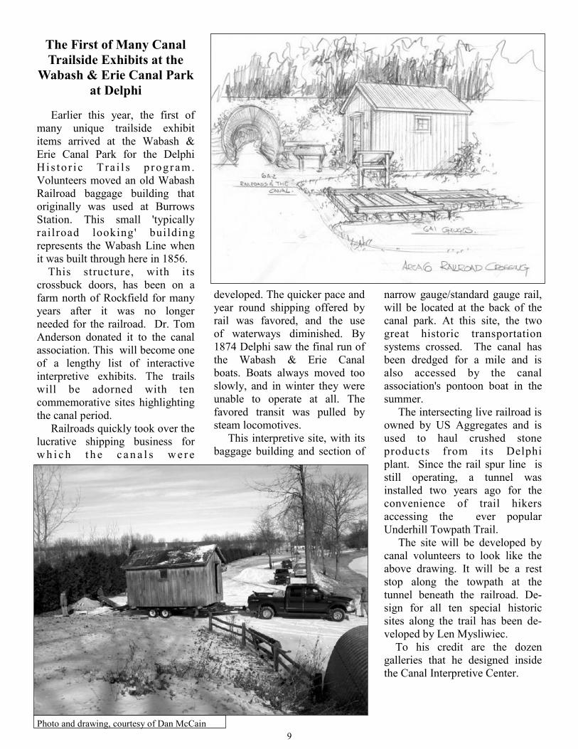
narrow gauge/standard gauge rail,
will be located at the back of the
canal park. At this site, the two
great historic transportation
systems crossed. The canal has
been dredged for a mile and is
also accessed by the canal
association's pontoon boat in the
summer.
The intersecting live railroad is
owned by US Aggregates and is
used to haul crushed stone
products from its Delphi
plant. Since the rail spur line is
still operating, a tunnel was
installed two years ago for the
convenience of trail hikers
accessing the ever popular
Underhill Towpath Trail.
The site will be developed by
canal volunteers to look like the
above drawing. It will be a rest
stop along the towpath at the
tunnel beneath the railroad. De-
sign for all ten special historic
sites along the trail has been de-
veloped by Len Mysliwiec.
To his credit are the dozen
galleries that he designed inside
the Canal Interpretive Center.
developed. The quicker pace and
year round shipping offered by
rail was favored, and the use
of waterways diminished. By
1874 Delphi saw the final run of
the Wabash & Erie Canal
boats. Boats always moved too
slowly, and in winter they were
unable to operate at all. The
favored transit was pulled by
steam locomotives.
This interpretive site, with its
baggage building and section of
The First of Many Canal
Trailside Exhibits at the
Wabash & Erie Canal Park
at Delphi
Earlier this year, the first of
many unique trailside exhibit
items arrived at the Wabash &
Erie Canal Park for the Delphi
Hi s to r i c Tra i l s p rogr am.
Volunteers moved an old Wabash
Railroad baggage building that
originally was used at Burrows
Station. This small 'typically
rai lroad looking' building
represents the Wabash Line when
it was built through here in 1856.
This structure, with its
crossbuck doors, has been on a
farm north of Rockfield for many
years after it was no longer
needed for the railroad. Dr. Tom
Anderson donated it to the canal
association. This will become one
of a lengthy list of interactive
interpretive exhibits. The trails
will be adorned with ten
commemorative sites highlighting
the canal period.
Railroads quickly took over the
lucrative shipping business for
w h i c h t h e c a n a l s w e r e
Photo and drawing, courtesy of Dan McCain

10
NEWS FROM THE CANAL
SOCIETY OF OHIO
Frank Trevorrow, one of the
original CSO founding fathers,
died September 18, 2007, in Ober-
lin, Ohio, at the age of 106. Frank
had remained active in the CSO
affairs well past the age of 100.
He authored many articles and
maps in the CSO quarterly,
"Towpaths," and his 1973 book,
Ohio Canals, a collection of
many of those articles and maps,
is one of the standard texts on
Ohio canals. Anyone who has
studied the Ohio canals has cer-
tainly encountered some of his
work. He will be missed.
The Ohio Historical Society
has announced the receipt of a
$2.4 million grant from the Ohio
DOT for the reconstruction of
the "Big Lock" (number 1 south)
at Lockington on the Miami and
Erie Canal. An article by the late
Bob Mueller, concerning the
s i tuation in Lockington,
appeared in American Canals in
the early 1990s. Many CSNJ
members also viewed this lock
on their field trip to Ohio in
1997. This project is anticipated
to be the first part of three
phases to stabilize and restore
the Lockington site. Work will
begin in the summer of 2008.
The wooden support frame
inside the lock will be removed.
The fill behind the walls will be
removed, the walls straightened,
and gates installed. A new
drainage system will eliminate
the settling and the leaning of
the walls. For those who have
seen the site, Lock 1 is the
fifteen-foot lift lock at the top of
the hill next to the canal keeper's
house (formerly a fire station).
Lockington Locks is part of
the Piqua Historical Area State
Memorial. Site Manager. and
CSO Trustee Andy Hite was
instrumental in obtaining the
funds for this project. The Piqua
park is the home to the new
aluminum-keeled replica canal
boat General Harrison of Piqua,
which has been most successful
since its launching in 2002.
LEARN THE ARCHAIC
SKILL OF LOCK TENDING
Just mention in a conversation
that you have experience working
as a locktender and watch jaws
drop as you explain the job. List
on your resume your experience in
raising boats as much as ten feet,
and you will induce much
curiosity and wonderment at the
personnel office.
Locktending is a very rare posi-
tion in the United States, seen
only in a few state parks and at the
C&O Canal National Historical
Park in Maryland and Washing-
ton, D.C. Few people ever get a
chance to do or even see this
activity, yet, if the Lowell canals
are in your backyard, here is your
chance.
If you are physically able to
move a heavy canal gate arm
mounted on a pivot, use your back
properly, follow safety proce-
dures, and work four-five hours
per week in the summer and early
fall, you, too, could learn the
skills of being a locktender.
This job is available on a daily
basis from late June through early
September and on weekends
through Columbus Day.
Reflect on what your career may
have been if you were working in
18th-, 19th-, and early 20th-
century America. Call the Lowell
Volunteer Office at 978-275-1740
and talk to them about this almost
bygone position that once
employed many individuals
and families living in special lock
houses along America’s thousands
of miles of canal ways.
SHARING THE SHOVELS
RESTORATION BEGINS
On the misty morning of March
14th, the Friends of the Delaware
Canal welcomed stakeholders and
supporters to Lock 24/Fish Ladder
in Easton, Pennsylvania, to
celebrate the long-awaited start of
the major flood repair work on the
Delaware Canal. State Representa-
tive Robert Freeman, Easton Mayor
Salvatore Panto, Williams Town-
ship Supervisor Fred Mebus, Penn-
sylvania State Park officials,
Delaware and Lehigh National
Heritage Corridor staff, Delaware
Canal State Park Advisory Commit-
tee members, a representative from
the Canal Society of New Jersey,
Popple Construction, BiState
Construction, and members of the
Friends gathered in front of
Popple’s fully-extended long-arm
track excavator. The crowd
stretched from one end of the
excavator to the other!
All in attendance expressed their
hopes for the Delaware Canal’s new
beginning and wishes that the
construction project will flow
smoothly and quickly. David
Kemmerer, Assistant Director of the
PA Bureau of State Parks, and
Terry Purcell, Delaware Canal State
Park Maintenance Manager, both
quipped that they hoped that the
work would be completed before
their rapidly approaching retirement
dates.
The highlight of the celebration
was a “sharing of shovels,”
during which Tom Williams, Presi-
dent of the Friends’ Board of Direc-
tors, and his three-year-old grand-
daughter, Cora Anderson, presented
beribboned shovels to the represen-
tatives of the two construction com-
panies. (Cora, dressed in a bright
pink vest that perfectly matched the
bow on her little shovel was more
(continued on page eleven)

11
than ready to convey the hopes
of future generations.)
The “sharing of shovels”
demonstrated that the Friends of
the Delaware Canal and the PA
Department of Conservation and
Natural Resources, which have
been undertaking comparatively
small flood repair projects, are
happy to have new help with the
“big” job.
Since the first river flood of
2004, the Friends have been
dealing with the consequences.
Special clean-ups were waged
after each of the inundations and
significant, innovative repairs
were completed.
The rushing waters from the
flood of September 2004 caused
the canal bank to break and the
towpath to severely erode in the
vicinity of the David Library of
the American Revolution in
Washington Crossing. This
damage was tackled by the
Friends. A contractor was hired
to line the canal prism with
geosynthetic material and
re-establish the towpath surface
using a potentially more flood-
res i s t an t method ca l l ed
“stabilized turf.” This project
allowed the PA Bureau of State
Parks to test stabilized turf to
determine its suitability for other
sections of the canal. The
completion of the repair, which
cost $102,000, allowed the
southern twenty-five miles of the
Delaware Canal, from New
Hope to Bristol, to be rewatered.
The towpath in this same
location was again damaged by
the flood of April 2005. The
erosion was less severe thanks to
the positive performance of the
geosynthetic liner and the
stabilized turf. This $47,000
repair was again funded by the
Friends, and water was restored
to the southern end of the canal.
Canal structures also take
beatings during floods. The
structural crossbars of the
Thompson-Neely camelback
bridge, located in the midst of the
northern section of the Washing-
ton Crossing Historic Park, were
dislodged by high water. With
Department of Community and
Economic Development grants
secured by then State Senator Joe
Conti and private contributions,
the Friends funded emergency
stabilization and later funded
restoration of this bridge, one of
only six authentic camelback
bridges that remain along the
canal.
The Friends intend to keep on
tackling flood-related projects as
does the state park. So along with
the “big” job contractors, we’ll
surely bring the Delaware Canal
back to its old self and make it
even better.
The Goal – A More Stable
Towpath Core and
Surface
If you’ve had the opportunity
to examine any of the towpath
bank blowouts along the
Delaware Canal, you will have
seen that the canal bank was
built simply of earth and stone.
To try to make the canal more
flood resistant, the engineers
from DCNR’s Bureau of Facility
Design and Construction have
devised a reconstruction plan that
involves installing a stable core
material within the bank, provid-
ing a liner that is more reliably
impervious than clay, and laying
down a trail surface that will be
less prone to erosion.
In areas where the towpath bank
has been totally washed away, the
construction specifications call for
the installation of stacked gabion
baskets that will serve as a core.
A gabion is a wire mesh basket,
about 3 feet high by 3 feet wide
by 6 feet long, that is filled with
stone. Gabions act like building
blocks.
To repair a blowout, a layer of
large stone is laid as a base. Then
gabions are placed side by side
along the length of the blowout.
Another layer can be added if
needed to fill the void. Several
feet of dirt covers the baskets;
then a layer of bentomat, geotex-
tile material, is put down. The
bentomat, which functions more
reliably than clay, extends from
the bottom of the canal prism up
and over the towpath area to the
far side. Another layer of dirt is
placed on top of the bentomat.
The towpath trail surface will be
“stabilized turf,” consisting of
(continued on page fourteen)
Standing in front of the
excavator are Terry Pursell,
Delaware Canal State Park
Maintenance Supervisor;
Rick Dalton, Delaware Canal
State Park Manager; Tom
Williams, President, Friends
of the Delaware Canal;
Armand Cencetti, Popple
Construction; Greg DiNardo,
Bi-State Construction; Fred
Mebus, Williams Twp.
Supervisor; and Susan Taylor,
Executive Director, Friends
of the Delaware Canal.

12
Ship Lifts in Germany
by Eckhard Schinkel
(Hg.).English Translation by Roy
Kift. Essen and Dortmund,
Germany.: Klartext-Verlag and
Westphalia-Lippe (LWL) Indus-
trial Museum, 2007. 129pp. 140
color and b&w illust., 2 maps, 8
Data and Facts Tables, bibliogra-
phy, table of contents. € 10.95 sb
(ISBN 978-3-89861-752-9).
Eckhard Schinkel has written a
riveting and intriguing journey
into the world of ship lift
technology in general and German
ship lifts in particular. His detailed
account in German Ship Lifts is
not only very well-illustrated, but
also contains a highly readable
text of the historical origin of ship
lifts, their German descendants,
and how they operated, all
presented in a lively and
enthusiastic manner. Make no
mistake that it takes both knowl-
edge and the ability to tell the
story well that results in a book of
this quality.
The book is divided into four
parts. The first introduces us to
“The Fascinating World of Ship
Lifts.” This is primarily a histori-
cal treatment covering the period
from the earliest slipways in
Greece and Egypt to move boats
overland before the time of Christ
to the present high lifts (113 and
114 meters, 373 and 376 feet
respectively) being constructed at
the Three Gorges Dam and on the
Jinsha River in China. It has just
the proper technical detail to whet
our appetites for more. Between
these temporal bookends, Dr.
Schinkel touches on Western
civilization’s first attempt to unite
the Rhine and Danube River
basins by Charlemagne in 793 at
the Fossa Carolina in southern
Germany and the development
of inclines and vertical mechani-
cal lifts that led to Johann
Friedrich Mende building the
first lift in Germany in 1789.
The narrative continues with a
brief discussion of the English
model of inclines and the
technology transfer to Prussia
including the American model
through the contribution of
Georg Jacop Steenke on the
Oberland Kanal of eastern
Prussia (now the Elblag in
Poland) who in 1850 was
influenced by the inclines on the
Morris Canal in New Jersey.
The chronicle then leads us to
the later 19th century and earliest
20th century vertical ship lifts in
Europe and Germany: the
Anderton Lift in England, the
hydraulic lift at Les Fontinettes
in northern France, Belgium’s
vertical lifts at La Louvière on
the Canal du Centre and the
Henrichenburg Ship Lift north of
Dortmund. Ship lifts from
around the world are discussed,
including both visions never
built, such as the Eads 1880 plan
for a ship railway instead of a
canal across Panama, and those
built, such as the 2002 highest
lift (73 meters, 240 feet) in all of
Europe at Strépy Thieu on the
new rerouted segment of the
Canal du Centre. This epic
journey back through the arch of
time is enhanced by many
relevant images of paintings,
drawings, diagrams and museum
models that wonderfully clarify
the text.
The first part of Dr. Schinkel’s
book is not a mere recitation of
facts, figures, dates, and
mechanisms of lift operation; all
the lifts are explained within a
context of major historical
events and social outlooks of the
times. Linkages are made not only
to the technological past but also
to contemporary realities and cul-
ture at the time of their
construction.
The technological development
in the first part of the book gives
way in the second to a discussion
of the individual ship lifts in
Germany from 1789 to 2011.
Again Eckhard interweaves
human history, architecture, and
technology, thereby coupling
places and structures with the
need to built them and the people
who planned and brought them to
fruition. Major political themes
and historical events such as the
unification of Germany by
Bismarck, the two World Wars,
and the Cold war are fleshed out
and form the contextual frame-
work upon which the narratives of
each lift unfolds.
Chapter two is a chronology of
boat elevator construction in
Germany and begins with
Euromapping’s splendid map of
mainland Europe, showing the
location, names, and dates of the
ship lifts of Germany and
neighboring countries (excluding
the two water slopes in the south
13
of France - one on the Canal du
Midi and the other on the Canal
Latèral à la Garonne). The text
begins with a section on the
Halsbrücke Barge-Lift near
Freiburg Saxony (south of
Dresden) completed in 1789 by
J.F. Mende, a vertically rising dry
boat lift; that is followed
sequentially by segments devoted
to each lift in Germany as follows:
1899-1970—The Old Henrichen-
burg Ship Lift in Waltrop, a five-
float lift; 1934—The Old Nieder-
finow Ship Lift, a counterweight
ship lift; 1938—The Rothensee
Two Float Ship Lift and the
Hohenwarthe Twin Ship Lift,
planned but never built; 1962—
The New Henrichenburg Ship
Lift, a twin float lift; 1975—The
Lüneburg Twin Ship Lift near
Scharnebeck, counterweighted
double caissons; and 2011—The
New Niederfinow Ship Lift, now
under construction; counter-
weights. Sadly we discover that
the world’s two unique float ship
lifts operating in 2005-2006 have
since been closed.
Each ship lift portion describes
the history of the project played
out against the historical events of
the time and the personalities
involved, the construction phase,
technology, operation, architec-
ture, and its status or condition
today. The informative text is
enhanced by many illustrations,
including some wonderful
engineering drawings and aerial
photographs. Also included are
focus tables (fact sheets) for each
lift containing the necessary
engineering details of the site,
type of lift, lifting height, trough
dimensions, weight of the
caissons, drive mechanisms and
horsepower, construction firm,
opening date, and so forth. A
wealth of information is
succinctly presented.
Chapter three is a brief one,
focusing on the Chinese-German
joint venture constructing the
vertical ship lift at the Three
Gorges dam, and again it is
wonderfully illustrated and well
written. I was greatly intrigued
to learn that there may be as
many as fifty inclined planes and
vertical lifts in China, but very
little information has reached the
general public. But what is
known is that the majority of the
ship lifts in the world are in
China.
The final chapter is for the
reader who is not well
acquainted with ship lifts. Here
Schinkel presents some basic
principles of ship lift operation,
and it deserves merit for
simplicity and, therefore, its
potential appeal to the general
public.
One slightly negative point
from my perspective is, although
the English translation in italics
appears adjacent to or beneath
the German I would have
preferred it also to have a
different font size or thickness
from the German so that it
would be more readily apparent
especially in “close quarters”
such as the fact/data focus boxes
and figure captions.
Eckhard Schinkel’s Ship Lifts
in Germany is a must read for
any one interested in canals, the
history of technology, or history
in general. But it also should
have great appeal to a broad
audience. Beginners, specialists,
serious students of the field, and
casual bystanders alike will find
this work to be of great benefit.
It is well researched, well
written, beautifully illustrated,
and factually correct, in short a
superb treatment.
Thomas X. Grasso
FROM THE PRESIDENT (continued from page one)
improve the canal around Lock 5,
which was planned just before the
flooding and then put on hold.
Once these projects are com-
pleted, probably in 2009, the sup-
porters of the canal can return to
the long range task of making the
canal more accurately reflect its
claim of being the “only intact
towpath era canal.” With hard
work, one day, we may even able
to navigate this canal in real boats.
TO GET YOUR COPY:
Ship Lifts in Germany can be
purchased by contacting the
museum at the Henrichenburg
Shiplift in Dortmund/Waltrop—the
LW L ( W es t p h a l i an - Li p p e )
Industrial Museum. The museum’s
website is:
w w w . s c h i f f s h e b e w e r k -
henrichenburg.de; you may send an
email to the museum at
You may also contact Eckhard
Schinkel directly at e.schinkel@
lwl.org or eckhard.schinkel@lwl.
org.
THE SCHUYLKILL RIVER
TRAIL EXPANSION IS OPEN!
The Schuylkill River Trail
expansion to the Longford Road/
Port Providence trailhead was
opened on April 14, 2008, by the
Montgomery County commission-
ers. Trail users can now bike,
hike,
run, or
roller
blade
from
Port
Provi-
dence to
Philadel-
phia.

14
CANALENDER
July 12—Canal and Rail Fest,
Cum- berland, MD;
www.candocanal.org
July 20—Locktender’s Open
House, canoe and kayak float;
Lock 60, Schuylkill Canal Park;
Mont Clare, PA; 610-917-0021;
www.schuylkillcanal.com.
August 17—Locktender’s Open
House, canoe and kayak float;
Lock 60, Schuylkill Canal Park;
Mont Clare, PA; 610-917-0021;
www.schuylkillcanal.com.
September 14 – 17, 2008—World
Canals Conference, Rideau Canal,
Kingston, Ontario, Canada. For
more details, visit
www.canals2008.com.
September 21—Locktender’s
Open House, canoe and kayak
float; Lock 60, Schuylkill Canal
Park; Mont Clare, PA; 610-917-
0021; www.schuylkillcanal.com
October 10-12—Canal Society
of Indiana Fall Field Trip to the
Cross-Cut Canal & Greene
County, Indiana. Contact Bob and
Carolyn Schmidt, 5909 Chase
Creek Court, Fort Wayne, IN
46804; 260-432-0279;
indcanal@aol.
October 13-18—C&O Canal
through bike ride, Cumberland to
Georgetown. Contact Tom Perry
at 301-223-7010.
Oct 17 - 19—Pennsylvania Canal
Society Field Trip to Lower
Chesapeake & Ohio Canal, with
stops at the Monocacy Aqueduct,
Whites Ferry, Edwards Ferry,
Lock 25, Seneca Aqueduct , Lock
24 Violettes Lock, and Pennyfield
Lock. A tour of the refurbished
Great Falls Tavern Visitors Center
and a ride on the mule drawn
canal boat will be included in the
trip. For information, contact
Dave Johnson at 301-530-7473.
October, date not set yet. Canal
Society of Ohio tour in the
Akron/Portage Lakes portion of
the Ohio and Erie Canal. Larry
Turner is the tour chair. He can
be reached at (330) 658-8344,
The Farmington Canal in
Plainville, Connecticut, by Ruth
S. Hummel, was published last
year by the Plainville Historical
Society.
Ruth Hummel has been
president of the PHS for many
years. She has been an aficio-
nado of the Farmington (aka
New Haven - North Hampton)
Canal for, by her admission,
thirty-seven years. In that time,
and successively with partners
Mel Schneidermeyer and
Dr. Carl Walter, she has taken a
strong hand in restoring a
segment of the canal in
Plainville; publishing a map of
the entire Farmington Canal;
collecting and studying photos,
diaries, artifacts and stories about it;
and leading tours groups to key
sites along the canal. She has
written over 900 articles on local
history for newspapers and over
ninety shows for public access TV
(locally Nutmeg, Channel 5). Ruth
has spoken to the American Canal
Society and, with Carl Walter, led a
tour for the Canal Society of New
Jersey. Now, at age 77, she has
written a book to make the stories
she has learned more widely
available.
Clearly, the book is a wonderful
compilation of Ruth’s stories. It is
an easy read, with 27 short chapters
and illustrations about the planning
and construction of the canal, the
boats, the people, the critters, the
cargos hauled and other uses, and
finally its demise; in short, just
about every conceivable aspect of
the Farmington Canal. And, of
course, more than a few of her
observations pertain to many of our
other historic canals as well.
The book, a “must-have” for
anyone interested in the history of
the canal era in the US, is available
from the PHS, 29 Pierce Street,
Plainville CT 06062; $15 mail
order, plus $2.50 S&H, or call 860-
747-6577 for price and ordering.
TOWPATH SURFACE (cont’d)
85% stone aggregate mixed with
15% topsoil seeded with a special
non-clumping grass. The stabi-
lized turf will not be as smooth as
the argillite gravel trail, but will
hold together better in a flooding
situation.
Bentomat and stabilized turf
were used for towpath bank
repairs in 2004 and 2005, and the
gabion/bentomat/stabilized turf
solution was used for the repair of
a 100-foot blowout south of
Easton in 2006. The materials
and methods seem to be working.