canisteo wind transmission facility
TRANSCRIPT
Canisteo Wind Transmission Facility
Case No. 19-T-0041
Exhibit 4
ENVIRONMENTAL IMPACT
Revision 12
EXHIBIT 4 Canisteo Wind Energy, LLC Page i Canisteo Wind Farm Transmission Facility
EXHIBIT 4 - ENVIRONMENTAL IMPACT
TABLE OF CONTENTS
Introduction ................................................................................................................................ 1
Construction and Operational Methods/Procedures ................................................................... 2
Right-of-Way and Land Ownership ......................................................................................... 2
Construction Methods and Schedule ...................................................................................... 3
Substation Construction ...................................................................................................... 3
Transmission Line Construction .......................................................................................... 4
Description of Study Area .......................................................................................................... 4
Land Use ................................................................................................................................... 5
Floodplains ............................................................................................................................. 6
Agricultural Districts ................................................................................................................ 7
Conformance with Comprehensive Plans ............................................................................... 7
Community Outreach .............................................................................................................11
Potential Effects and Mitigation ..............................................................................................12
Environmental Site Assessment ............................................................................................12
Topography, Geology, and Soils ...............................................................................................13
Topography ...........................................................................................................................13
Geology .................................................................................................................................13
Soils ......................................................................................................................................13
Potential Effects and Mitigation ..............................................................................................16
Vegetative Communities ...........................................................................................................17
Terrestrial Communities .........................................................................................................17
Aquatic Communities .............................................................................................................19
Environmental Effects and Mitigation .....................................................................................19
Vegetation Management Plan................................................................................................20
Fish and Wildlife Resources ......................................................................................................21
Existing Environment .............................................................................................................21
Wildlife Species .................................................................................................................21
Fish and Benthic Communities ..........................................................................................22
Threatened and Endangered Species ................................................................................23
Environmental Effects and Mitigation .....................................................................................24
Wetlands and Hydrology ...........................................................................................................25
Surface Waters and Ground Water ........................................................................................26
Wetlands ...............................................................................................................................29
Environmental Effects and Mitigation .....................................................................................31
Aesthetic, Visual and Recreational Resources ..........................................................................34
Existing Resource Inventory ..................................................................................................35
Viewshed Analysis .............................................................................................................36
Visual Simulations .............................................................................................................36
Environmental Effects and Mitigation .....................................................................................37
EXHIBIT 4 Canisteo Wind Energy, LLC Page ii Canisteo Wind Farm Transmission Facility
Cultural Resources ...................................................................................................................37
Background .......................................................................................................................37
Archaeological Resources Survey .........................................................................................38
Architectural/Historic Property Structures Survey ..................................................................38
Impacts and Mitigation ...........................................................................................................41
Archaeological Resources .................................................................................................41
Historic Property Visual Resources ....................................................................................41
Noise Impacts ...........................................................................................................................41
Construction ..........................................................................................................................42
Operation ..............................................................................................................................43
Electric and Magnetic Field Strengths .......................................................................................43
References ...............................................................................................................................45
Introduction ................................................................................................................................ 1
Construction and Operational Methods/Procedures ................................................................... 2
Right-of-Way and Land Ownership ......................................................................................... 2
Construction Methods and Schedule ...................................................................................... 3
Substation Construction ...................................................................................................... 3
Transmission Line Construction .......................................................................................... 4
Description of Study Area .......................................................................................................... 4
Land Use ................................................................................................................................... 5
Floodplains ............................................................................................................................. 6
Agricultural Districts ................................................................................................................ 7
Conformance with Comprehensive Plans ............................................................................... 7
Community Outreach .............................................................................................................11
Potential Effects and Mitigation ..............................................................................................12
Environmental Site Assessment ............................................................................................12
Topography, Geology, and Soils ...............................................................................................13
Topography ...........................................................................................................................13
Geology .................................................................................................................................13
Soils ......................................................................................................................................13
Potential Effects and Mitigation ..............................................................................................16
Vegetative Communities ...........................................................................................................17
Terrestrial Communities .........................................................................................................17
Aquatic Communities .............................................................................................................19
Environmental Effects and Mitigation .....................................................................................19
Vegetation Management Plan................................................................................................20
Fish and Wildlife Resources ......................................................................................................21
Existing Environment .............................................................................................................21
Wildlife Species .................................................................................................................21
Fish and Benthic Communities ..........................................................................................22
Threatened and Endangered Species ................................................................................23
Environmental Effects and Mitigation .....................................................................................24
EXHIBIT 4 Canisteo Wind Energy, LLC Page iii Canisteo Wind Farm Transmission Facility
Wetlands and Hydrology ...........................................................................................................25
Surface Waters and Ground Water ........................................................................................26
Wetlands ...............................................................................................................................29
Environmental Effects and Mitigation .....................................................................................31
Aesthetic, Visual and Recreational Resources ..........................................................................34
Existing Resource Inventory ..................................................................................................35
Viewshed Analysis .............................................................................................................36
Visual Simulations .............................................................................................................36
Environmental Effects and Mitigation .....................................................................................37
Cultural Resources ...................................................................................................................37
Background .......................................................................................................................37
Archaeological Resources Survey .........................................................................................38
Architectural/Historic Property Structures Survey ..................................................................38
Impacts and Mitigation ...........................................................................................................41
Archaeological Resources .................................................................................................41
Historic Property Visual Resources ....................................................................................41
Noise Impacts ...........................................................................................................................41
Construction ..........................................................................................................................42
Operation ..............................................................................................................................43
Electric and Magnetic Field Strengths .......................................................................................43
References ...............................................................................................................................45
LIST OF TABLES
Table 4-1. Land Cover Types Along Transmission Facility Route .............................................. 5
Table 4-2. Soil Series within Transmission Facility ROW ..........................................................14
Table 4-3. Soil Characteristics ..................................................................................................15
Table 4-4. Occurrences of Vegetative Communities ................................................................18
Table 4-5. Federally- and State-listed Species in the Vicinity of the Transmission Facility ........23
Table 4-6. Streams identified in the 200-foot study corridor around the proposed Transmission
Facility ......................................................................................................................................26
Table 4-7. Wetlands identified in the 200-foot study corridor .....................................................29
Table 4-8 Potential Wetland Impacts .........................................................................................32
Table 4-9 Potential NYSDEC Adjacent Area Impacts ................................................................33
Table 4-10. Visually Sensitive Resources Types and Occurrence within the Visual Study Area 35
Table 4-11. Predicted Construction Noise Levels ......................................................................42
Table 4-1. Land Cover Types Along Transmission Facility Route .............................................. 5
Table 4-2. Soil Series within Transmission Facility ROW ..........................................................14
Table 4-3. Soil Characteristics ..................................................................................................15
Table 4-4. Occurrences of Vegetative Communities ................................................................18
Table 4-5. Federally- and State-listed Species in the Vicinity of the Transmission Facility ........23
EXHIBIT 4 Canisteo Wind Energy, LLC Page iv Canisteo Wind Farm Transmission Facility
Table 4-6. Streams identified in the 200-foot study corridor around the proposed Transmission
Facility ......................................................................................................................................26
Table 4-7. Wetlands identified in the 200-foot study corridor .....................................................29
Table 4-9 Potential NYSDEC Adjacent Area Impacts ................................................................33
Table 4-10. Visually Sensitive Resources Types and Occurrence within the Visual Study Area 35
Table 4-11. Predicted Construction Noise Levels ......................................................................42
LIST OF FIGURES
Figure 4-1: FEMA Flood Plains
Figure 4-2: Agricultural Districts
Figure 4-3: Vegetative Communities
EXHIBIT 4 Canisteo Wind Energy, LLC Page 1 Canisteo Wind Farm Transmission Facility
ENVIRONMENTAL IMPACT
This Exhibit addresses the requirements of 6 NYCRR § 86.5.
Introduction
Canisteo Wind Energy, LLC (the Applicant) (CWE) proposes to construct and operate the
Canisteo Wind Transmission Facility consisting of an approximately 15-mile 115 kV overhead
Transmission Facility and a new point-of-interconnection substation (hereinafter referred to as the
Transmission Facility). The Transmission Facility will connect the proposed Canisteo Wind
Energy Facility in the Towns of Canisteo, Cameron, Greenwood, Jasper, West Union, and
Troupsburg, Steuben County, New York (Canisteo Wind Farm DPS Case Number 16-F-0205) to
the regional grid through the existing Bennett Substation in the Town of Hornellsville, Steuben
County, New York (see Figure 2-1).
The Transmission Facility will be comprised of the following components:
Approximately 15 miles of 115 kV overhead transmission line located in the City of Hornell,
the Towns of Jasper, Canisteo, and Hornellsville. and the Village of Canisteo. Structure
locations where steel monopoles will be used will have a designated right-of-way (ROW)
of 80-feet. All other sections of the ROW will have a 100-foot ROW. Steel monopoles will
be used in certain areas to reduce and mitigate Facility impact (e.g., farm fields);
A collection substation in the Town of Jasper associated with CWE. The collection
substation will step up electricity generated by CWE turbines from 34.5 kV to 115 kV. The
“low side” of the collection substation (i.e., 34.5 kV) falls under New York Public Service
Law (PSL) Article 10, while the “high side” (i.e., 115 kV) of the collection substation falls
under PSL Article VII; and
A point of interconnection (POI) at the existing Bennett Substation which is owned by
NYSEG and located on State Route 32 in the Town of Hornellsville. The POI is anticipated
to occur within an existing open switch and will not require any additional improvements.
As the Transmission Facility is greater than 100 kV and exceeds 10 miles in length, the Applicant
is subject to Article VII of the Public Service Law. The proposed Transmission Facility, including
the “high side” of the collection substation, is subject to 16 NYCRR Part 86, which Section 86.5
requires a statement of the impact of the proposed facility on the environment. The studies of
anticipated environmental impacts are addressed herein.
The CWE Transmission Facility will comply with all applicable federal, state, and local laws,
ordinances, and policies addressing impacts on the environment during construction and
operation/maintenance (physical conditions, land uses, and biological resources). The CWE
Transmission Facility was sited and will be constructed in a way that avoids or minimizes
environmental impacts within and adjacent to the proposed right-of-way (ROW) and substation
properties to the maximum extent practicable.
EXHIBIT 4 Canisteo Wind Energy, LLC Page 2 Canisteo Wind Farm Transmission Facility
Field evaluations, existing data review, and agency consultations were conducted to identify,
quantify, and describe existing environmental conditions in the vicinity of the Transmission
Facility. Field evaluations addressed physical conditions (e.g., geology, surface waters),
biological resources (e.g., vegetation, wildlife, aquatic resources), and land use (e.g., agriculture,
scenic areas) in the vicinity of the Transmission Facility. Existing data collected and analyzed as
part of the review included, but were not limited to, Steuben County Soil Surveys, New York State
Department of Environmental Conservation (NYSDEC) Freshwater Wetland Maps, U.S. Fish &
Wildlife Service (USFWS) National Wetland Inventory (NWI) Maps, recent high resolution aerial
photography (April, 2018), U.S. Geological Survey (USGS) topographic quadrangle maps, and
Federal Emergency Management Agency (FEMA) Flood Insurance Rate Map (FIRM) floodplain
mapping. In addition, data collected for studies related to the Canisteo Wind Farm (e.g., Wetland
Delineation, Invasive Species Control Plan) were also reviewed. Consultations were conducted
with local municipalities, the New Yok State Department of Public Service (NYSDPS), NYS
Department of Environmental ConservationNYSDEC, New York State Office of Parks, Recreation
and Historic Preservation (NYSOPRHP), New York State Department of Agriculture and Markets
(NYSDAM), U.S. Army Corps of Engineers (USACE), and the USFWS, and included letters,
telephone and electronic communication, off-site meetings, and on-site field reviews.
The results of these investigations are presented below by resource type. The descriptions of
existing conditions are followed by an assessment of the potential impacts to each resource that
may result from construction and operation of the CWE Transmission Facility. Measures to reduce
impacts are described in this Exhibit.
Construction and Operational Methods/Procedures
As previously stated, the Applicant proposes to construct, operate, and maintain the Transmission
Facility to transmit power from the proposed Canisteo Wind Energy Facility to the regional power
grid. The transmission line will run approximately 15 miles from the proposed collection
substation (in the Town of Jasper), through the Towns of Jasper, Canisteo, and Hornellsville, the
City of Hornell and the Village of Canisteo to the POI substation in the Town of Hornellsville. The
transmission line will terminate at the existing NYSEG Bennett Substation property. The proposed
route is depicted in Figures 2-1 and 2-3.
Right-of-Way and Land Ownership
The proposed collection substation, located in the Town of Jasper, will be constructed entirely
within one privately owned parcel (305.00-03-003.000), leased by the Applicant. The POI
substation, located in the Town of Hornellsville, is located on land owned by NYSEG. Land along
the Transmission Facility is privately owned. The Applicant has obtained easements, or is in
advanced stage of negotiations, to construct, operate, and maintain the Transmission Facility and
ROW from each property owner along the Transmission Facility route.
EXHIBIT 4 Canisteo Wind Energy, LLC Page 3 Canisteo Wind Farm Transmission Facility
Construction Methods and Schedule
The CWE Transmission Facility will be constructed as reflected on the Preliminary Design
Drawings (see Exhibit 5). A detailed construction schedule will not be finalized until final Facility
approval is granted and contracts have been awarded to all contractors. Upon receipt of all
required permits, and approvals and following completion of all required notifications, the
Applicant’s contractor will prepare the site for construction. All construction activities will be
conducted in accordance with Certificate Conditions and Best Management Practices (BMPs). All
contractors will also be required to adhere to the Applicant’s health and safety requirements.
Construction of the Project will involve the following activities:
Installation of Stormwater Pollution Prevention Plan (SWPPP) prescribed temporary
erosion and sediment controls;
Designation of areas for vegetation clearing, trimming, and disposal;
Site grading;
Installation of access roads and any laydown yards;
Excavation for tower and substation foundations;
Installation of grounding system;
Substation erection;
Fence installation;
Installation of poles;
Wire stringing;
Installation of permanent stormwater control structures (if needed); and
Clean-up and restoration, including any plantings.
Substation Construction
Substation construction will involve the following activities:
Installation of temporary erosion and sediment controls, and maintenance and protection
of traffic signage (as needed);
Designation of areas for vegetation clearing, trimming, and disposal;
Site grading;
Installation of access road and parking areas;
Excavation for station foundations, conduit, and trench;
Installation of the grounding system;
Station erection;
Fence installation;
Activities related to installation of the 115-kV connection (e.g., excavation for pole
foundations, pole erection); and
Clean-up and restoration, including any plantings.
Final site restoration will be conducted as required at any remaining disturbed sites. Cleanup
activities will involve removal of all debris from the site. Restoration activities will involve re-
EXHIBIT 4 Canisteo Wind Energy, LLC Page 4 Canisteo Wind Farm Transmission Facility
grading disturbed soils to restore contours to their preconstruction condition or to match adjacent
contours, and site stabilization and restoration. Any stockpiled topsoil will be evenly redistributed
in its former location. Site stabilization and restoration will be achieved through seeding and
mulching. All permanent seeding and tree and shrub planting work will be conducted during the
appropriate growing season. All erosion control devices will be removed following revegetation.
Transmission Line Construction
The construction of the transmission line will require the installation of steel and/or wood
monopoles, wood H-frame, and wood 3-pole structures at approximately 106107 locations along
the route. The ROW width and location are designed to reduce impacts to the maximum extent
practicable. Construction of the transmission line will involve the following activities:
Installation and maintenance of erosion and sediment control;
ROW preparation;
Structure erection,
Stringing of conductors; and
Clean-up and restoration.
Clearing of the ROW prior to and during construction will require the use of manual and/or
mechanical methods such as chainsaws, pruners, or heavy machinery. Portions of trees and other
vegetation that extend into the clearing regions may be trimmed. Low-growing vegetation that is
completely within the vegetation clearing area may be trimmed down to a low level or be
completely removed. Trees within the ROW will be completely removed for safety and ease of
access during construction. New transmission structures will be assembled and framed at each
structure site. After holes are augured, poles will be directly embedded in the holes and backfilled.
Blasting will only be used during pole installation if other techniques, such as auguring or
hammering, are not sufficient. Upon completion of new structure erection, the conductors will be
strung.
Temporary roads will be installed to provide workers and equipment access to the proposed
ROW. It is anticipated that the roads will be between 12 and 16 feet wide.
The Applicant will coordinate the construction activities of all the consultants and contractors to
assure that appropriate environmental standards are met. To the maximum extent possible,
natural vegetation buffers will be maintained adjacent to highway crossings, streams, rivers, and
wetlands. The placement of structures in wetland areas and on steep slopes will be avoided where
possible. During construction and operation, the Applicant will comply with all applicable water
quality standards for streams and wetlands, as required.
Description of Study Area
The study area was defined for the purposes of describing the existing environment and any
potential environmental effects by resource type. For all resource analysis concerning land use
and land features (geology, topography, soils, etc.), a study area of approximately 100 feet (50
feet on either side of the centerline of the proposed Transmission Facility) was evaluated. (the
EXHIBIT 4 Canisteo Wind Energy, LLC Page 5 Canisteo Wind Farm Transmission Facility
ROW). For ecological resources (vegetation, wetlands, etc.), a study area of 200 feet (100 feet
on either side of the centerline) was evaluated. For other resources, including visual and cultural
resources (e.g., historic structures), a study area of 3 miles and 1 mile, respectively, from the
centerline of the Transmission Facility was established.
Land Use
The Applicant has evaluated land/water uses within the Study Area, including200-foot study area,
which includes the Transmission Facility ROW and the collection substation site. Land and water
use around the substations and along the Transmission Facility were identified from local town
codes, tax parcel maps and New York State Office of Real Property (NYSORP) classification
codes, aerial photographs, and field verification during site visits conducted in 2018. Land use in
the vicinity of the Transmission Facility is characterized by a mix of undeveloped forest land,
successional old field and shrubland, agricultural land, wetlands, and suburban areas
characterized by low to medium density residential and light commercial development.
The existing land use for each component of the Transmission Facility are described below:
Transmission Facility
The proposed transmission line will travel approximately 15 miles through the City of Hornell, the
Towns of Jasper, Canisteo, and Hornellsville, and the Village of Canisteo (see Figures 2-1 and 2-
3 for the proposed route). Land use in the area can be generally described as forested or
agricultural with scattered residences along roadways.
The Towns of Jasper and Canisteo do not have any zoning regulations. The City of Hornell, the
Town of Hornellsville and the Village of Canisteo have adopted zoning laws. A full review of local
laws for each municipality is presented in Exhibit 7. (see Case Number 16-F-0205).
The transmission line runs through the Village of Canisteo for approximately 1 mile. The land uses
of the parcels through which the Transmission Facility runs include agriculture, vacant land,
community services, and public services. Based on the Village of Canisteo zoning map, the
transmission line and associated ROW cross parcels zoned as General Commercial (C), Medium
Density Residential (MDR) district and flood control zone (FCZ). The area where the utility line
passes through the City of Hornell was annexed to the city from Hornellsville and, at the present
time, is not included on current city zoning maps. See Exhibit 7 for additional information.
transmission line transmission line. The existing land cover types within the 100-foot study area
(the ROW) are summarized in Table 4-1, below.
Table 4-1. Land Cover Types Along Transmission Facility Route
Land Cover Type1 Acreage of ROW Percentage of ROW
Water 0.23 <0.011%
Developed 2.23.83 1.2.0%
Forest 91.1107.2 51.757.5%
Shrubland 6.57 3.75%
EXHIBIT 4 Canisteo Wind Energy, LLC Page 6 Canisteo Wind Farm Transmission Facility
Land Cover Type1 Acreage of ROW Percentage of ROW
Agriculture 63.362.9 35.933.7%
Wetland 12.85.1 2.7.3%
1 Source: USGS NLCD, 20112016
The CWE transmission line is not anticipated to significantly affect land use. The Transmission
Facility is sited in a rural area away from areas frequently used by the public. The footprint of the
Transmission Facility will be limited to the pole structures and will allow for continued agricultural
production.
Collection Substation Site
The collection substation and related infrastructure is proposed to be constructed on a 14.3-acre
parcel in the Town of Jasper. The parcel is located along County Route (CR) 63, west of North
Road. The site is bordered to the north by undeveloped land and to the south, east, and west by
agricultural fields. The land surrounding the parcel is primarily forested or agricultural fields with
scattered residences along roadways.
The collection substation associated with CWE is located on a parcel with minimal development
in the surrounding area. Land use codes from parcel mapping indicate that land surrounding the
collection substation is categorized as agricultural, rural/seasonal residences, or vacant. No
impacts to land use are anticipated as a result of the construction or operation of the collection
substation.
The POI substation associated with CWE is a currently existing substation south of the City of
Hornell. Minimal construction activities are planned for this site, therefore, no impacts to land use
are anticipated as a result of the Transmission Facility.
Floodplains
The Federal Emergency Management Act (FEMA) flood hazard maps
(https://msc.fema.gov/portal/home) indicate that portions of the Transmission Facility and
associated ROW are located in Zone AE, which is an area that has a 1% probability of flooding
every year (also known as a “100-year floodplain”). The floodplains are associated with the
Canisteo River and Colonel Bill’s Creek (see Figure 4-1). A total of 4432 poles are proposed to
be erected within 100-year floodplain areas, including monopole and H-frame structures. The
cross-section width of the floodplain for each pole location averages approximately 1,447 feet.
Each pole will account for approximately 10 square feet of fill within the floodplain, totaling an
estimated area of 440320 square feet within all impacted areas. When compared to the floodplain
width at each pole location, the addition of poles for the transmission line to the floodplain area is
not anticipated to negatively impact hydrologic functioning in the area or downstream, especially
considering the minimal impact this introduction will have in the context of other land use in the
area (e.g., croplands, farms, public roads, existing utilities, and residential development).
EXHIBIT 4 Canisteo Wind Energy, LLC Page 7 Canisteo Wind Farm Transmission Facility
Portions of the Canisteo River in the Town of Canisteo are designated as Floodwayfloodway
areas by FEMA (1984). However, based on a preliminary review of publicly available floodway
mapping (see Appendix 31d), it does not appear that any pole structures for the transmission line
may occur in a floodway area in the Town of Canisteo. Although floodways may exist, floodway
maps are not readily available within all mapped floodplains for each FEMA FIRM panel. The
Applicant will continue to consult with NYSDEC regarding the proposed transmission line in areas
where floodplains and floodways may exist.
As the construction and operation of the Transmission Facility will not require significant grading
or changes in topography, flood zones will not be permanently impacted. Additionally, erosion
controls will be employed during construction to minimize stormwater runoff and soil erosion. In
particular, the Applicant will prepare a SWPPP as required under NYSDEC’s State Pollutant
Discharge Elimination System (SPDES) General Permit for Stormwater Discharges from
Construction Activity. Prior to construction, erosion control devices will be installed between all
work areas and downslope surface waters to reduce the risk of soil erosion and siltation.
Following construction, disturbed areas will be stabilized and restored.
Agricultural Districts
Agricultural Districts are a designation authorized by the NYS Department of Agriculture and
Markets which aims to support agricultural operations and help prevent conversion of farmland to
non-agricultural uses. Agricultural Districts are not zoning districts per se but include several
benefits to farmers such as preferential real estate taxes, lawsuit protection for farmers to conduct
farming operations without risk of suit, and protection against overly restrictive local laws against
farming.
Approximately 5.72 miles of the transmission line and the proposed collection substation are
located within agricultural districts (see Figure 4-2). The transmission line will be constructed and
operated in a manner which still allows for continued agricultural production and minimal soil
disturbance to the land.
Conformance with Comprehensive Plans
A review of local laws and ordinances applicable to the Transmission Facility can be found in
Exhibit 7. A review of the following state and local comprehensive plans was conducted:
New York State Open Space Conservation Plan
Steuben County Economic Development Plan 2014 – 2015
Steuben County Agricultural & Farmland Protection Plan
Comprehensive Economic Development Strategy 2016 – 2021
Town of Hornellsville Comprehensive Master Plan (1970)
Town of Jasper Planning Studies (1978)
City of Hornell Comprehensive Plan (2002)
Village of Canisteo Comprehensive Plan (2009)
The relevant content of these plans in relation to the proposed Facility is summarized below:
EXHIBIT 4 Canisteo Wind Energy, LLC Page 8 Canisteo Wind Farm Transmission Facility
New York State Open Space Conservation Plan
The New York State Open Space Conservation Plan prepared by the NYSDEC and New York
State Office of Parks, Recreation, and Historic Preservation (NYSOPRHP) was approved by
former Governor Patterson in June 2009. This plan detailed the State’s recommended plans for
open space conservation and associated actions for responding to climate change, fostering
green healthy communities, connecting New Yorkers with nature and recreation, and
safeguarding the natural and cultural heritage of the area. Open space resources (wetlands,
historic resources, etc.) generically identified in this plan that are potentially affected by the
proposed Transmission Facility are discussed throughout this Exhibit. The proposed CWE
Transmission Facility is anticipated to have limited adverse effects on these resources and is
consistent with the Open Space Conservation Plan.
Steuben County Economic Development Plan (2014 - 2015)
The Steuben County Economic Development Plan was adopted in 2011. The overall goal of the
plan is to “implement a county-wide economic development strategy for Steuben County, New
York that will increase support of existing businesses, attract new business, develop an enhanced
business environment, and promote regional collaboration.” The plan establishes that there is an
opportunity for wind energy in Steuben County, with a potential for 200 megawatts (MW) of
additional wind power development. As the Transmission Facility is proposed to connect CWE
with the regional power grid, it is consistent with the Economic Development Plan.
Steuben County Agricultural & Farmland Protection Plan
The Steuben County Agricultural & Farmland Protection Plan was adopted in 2015 to promote
and enhance the county’s agricultural economy and to ensure that farming continues to play a
central role in the community. Five goals were established through community engagement with
farmers, residents, business owners, and stakeholders, to achieve the county’s vision. These
goals include:
Economic development
Agribusiness development
Farmland preservation
Agri-tourism
Education, outreach, and partnerships.
The plan identified encouraging the use of renewable resources of agricultural lands as a way to
meet the economic development goal. Strategies include developing local wind and solar power
ordinances to encourage farmers to implement projects on portions of their agricultural land. The
CWE Transmission Facility meets these objectives, as portions of the ROW include active
agricultural land and the Transmission Facility will not interfere with continued agricultural activity.
Comprehensive Economic Development Strategy 2016 – 2021
The Southern Tier Central Regional Planning and Development Board consists of Chemung,
Schuyler, and Steuben Counties. The board works with local government, economic and
EXHIBIT 4 Canisteo Wind Energy, LLC Page 9 Canisteo Wind Farm Transmission Facility
community development organizations, and human services agencies to improve the local
economy, environment, and the quality of life in the region. The board adopted a Comprehensive
Economic Development Plan in 2016. The plan identifies wind speeds that reach commercially
viable wind power levels as a notable and significant environmental resource of the region. The
report recognizes wind and solar energy development as a regionally significant source of
economic development.
Town of Hornellsville Comprehensive Master Plan
In 1970, the Town of Hornellsville published the third volume (Implementation Phase) of the
Comprehensive Master Plan. The implementation phase proposes a zoning ordinance and land
subdivision regulations, designed to ensure a high standard of development. The purpose of the
zoning ordinance was to encourage the most appropriate use of land throughout the Town of
Hornellsville while maintaining safety, promote health and general welfare, to prevent
overcrowding, regulate building sizes and densities, and identify appropriate locations of each
use within the town. Public utilities are listed as an approved use (with a Special Use Permit) in
the zoning ordinance. The land subdivision regulations were adopted as part of a plan for the
efficient and economical development of the town. All land to be subdivided shall be in harmony
with the development pattern of the neighborhood, for building purposes without danger to health,
and for improvements to location neighborhoods. The proposed Transmission Facility will not
require the subdivision of any lands.
Town of Jasper Planning Studies
The Town of Jasper Planning Studies was prepared by the Jasper Planning Board in 1978 under
the Comprehensive Planning Assistance Program of the New York Department of State. The plan
included an analysis of existing land use, physical features, populations, transportation, and
municipal facilities. The document lists 12 goals and objectives upon which the Development Plan
was based. The goals and objectives are listed below:
Measure the magnitude and direction of current development trends
Assess the probable impact of current development trends
Provide an information base to assist local officials in making decisions dealing with
development
Identify particular problems needing governmental attention
Assess the adequacy of town facilities
Determine the need for new town facilities
Identify growth potentials and problems
Evaluate the physical resources of the town in terms of their capability to support
development
Prepare a Land Use and Development Plan oriented towards
o Encourage efficient use of tax dollars through development
o Protect natural features and scenic values
EXHIBIT 4 Canisteo Wind Energy, LLC Page 10 Canisteo Wind Farm Transmission Facility
o Encourage the preservation of agriculture
o Discourage development in areas with natural development limitations or hazards
o Encourage the most appropriate use of land in order to enhance property values
and long-term development potential
Monitor State and Federal programs for potential impact or application to local needs
Identify major human resource needs and recommend potential solutions
Encourage inter-organizational cooperation.
The Transmission Facility is consistent with the Development Plan in its recommendations for the
natural environment and land use. The plan states that development should be discouraged or
strictly regulated in areas with slopes in excess of 15%, in areas that have poor drainage, in flood
hazard areas, and in poor soil areas, and that the rural character of the town should be
maintained. The collection substation and the portion of the transmission line that is within the
Town of Jasper generally avoids areas of steep slopes. Both the collection substation and
transmission line are located in a rural area that is not frequently visited by the public. These
facilities are not anticipated to detract from the rural character of the area. The Development Plan
also emphasizes the protection of open space and agriculture in the town. The Transmission
Facility passes through agricultural areas in the Town of Jasper. However, the footprint of the
Transmission Facility will be limited to the pole structures and the construction and operation of
the Transmission Facility will be done in a manner that will allowed for continued farming on
agricultural land over which the Transmission Facility passes. In addition, no portions of the
Transmission Facility are proposed to be constructed within flood hazard areas in the Town of
Jasper.
City of Hornell Comprehensive Plan
In October 2002, the City of Hornell approved the latest update of the City of Hornell
Comprehensive Plan. This is the first comprehensive plan that has been endorsed by the
Common Council since the 1960’s. The areas of focus have been arranged into (9) nine
Categories: Regional Issues and Inter-municipal Cooperation
Land Use
Housing Stock
Economic Development
Public Safety
Transportation and Infrastructure
Health and Welfare
Education, Culture and Religion
Parks, Recreation and Environment
In each of these categories, Existing Conditions, Planned Development and Goals, and Goal
Implementation strategies have been developed to guide the City in addressing the areas of
focus. Given the commercial and industrial nature of the uses in the southern edge of the City
EXHIBIT 4 Canisteo Wind Energy, LLC Page 11 Canisteo Wind Farm Transmission Facility
where the Transmission Facility will be located and its proximity to existing utility and
transportation corridors, the CWE Transmission Facility will not interfere with these objectives.
Village of Canisteo Comprehensive Plan
In November 2009, the Village of Canisteo Village Board approved the first draft of the Village
Comprehensive Plan.. Based on a community survey, and previous planning activity, several
general issues were identified as being areas of importance to Village residents and vital to the
enhancement of the community for now and many years to come. The areas of concern have
been arranged into (7) seven Categories:
Recognition and Evaluation of our current environment
Blight
Community Appearance and Atmosphere
Code Enforcement
Deteriorated state of Village Sidewalks
Short range remedies for improvement/beautification of the Village
Long range plan for improvement/beautification of the Village
In each of these categories, Goals, Objective, and Implementation strategies have been
developed to guide the Village in addressing the issues. The CWE Transmission Facility will not
interfere with these objectives, since it will be located in proximity to an existing utility corridor.
Community Outreach
An initial Public Involvement Program (PIP) Plan for CWE and the proposed transmission line
was submitted to the Siting Board on April 14, 2016. Comments on the PIP were received from
the DPS on May 16, 2016, and the PIP was updated, finalized and filed by the Applicant on March
16, 2017. The PIP can be accessed, viewed, and downloaded on the online case record
maintained by the Siting Board on Document Matter Master (DMM) and on the Facility-specific
website maintained by the Applicant:
http://documents.dps.ny.gov/public/MatterManagement/CaseMaster.aspx?MatterSeq=5
0610&MNO=16-F-0205
https://canisteowind.com/
Opportunities for public involvement since the PIP was filed include the following:
The Applicant has hosted a project website (https://canisteowind.com/), which includes
extensive information about the Transmission Facility, maps, a list of frequently asked
questions, and links to key project-related documents. The website provides a
mechanism to obtain information from, and provide comments to, the Applicant.
The Applicant has established a toll-free phone number (607-330-0399866-378-4580)
for public questions and comments.
EXHIBIT 4 Canisteo Wind Energy, LLC Page 12 Canisteo Wind Farm Transmission Facility
The Applicant has prepared a fact sheet and project information details for distribution to
the public and has hosted public forums to provide information about the Facility.
The Applicant has posted paper copies of all key documents, including the PIP, at the
following repositories:
o Canisteo Town Hall, 35 Main St., Canisteo, NY 14823
o Hornell Public Library 64 Genesee St., Hornell, NY 14843
o Jasper Town Hall 3807 Preacher Rd., Jasper, NY 14855
o Jasper Free Library, 3807 Library Street, Jasper, NY 14855
o Wimodaughsian Free Library, 19 W Main St., Canisteo, NY 14823
o Hornellsville Town Hall, 4 Park Avenue, Arkport, NY 14807
o Canisteo Village Hall, 8 Green Street, Canisteo, NY 14823
Potential Effects and Mitigation
In general, the proposed Transmission Facility is not anticipated to have an adverse impact on
local land uses and is consistent with state and local land use plans. Potential secondary impacts,
such as socioeconomic benefits, are addressed in Exhibit 6.
Because the proposed POI substation is an existing substation, and the collection substation will
be constructed entirely within a single parcel that is surrounded by undeveloped, vacant, or
agricultural land, impacts to land use are anticipated to be minimal. Permanent impacts will
include the conversion of a total of approximately three acres of agricultural land to built facilities,
including the collection substation and access road. Any temporary impacts caused by the
collection substation may include temporary access roads (as needed), or a laydown yard used
during construction, which will likely not exceed 1 acre in size.
For construction of the transmission line, 106107 tower structures will be erected. Prior to
construction, landowners immediately adjacent to the site will be notified that construction is
commencing and the anticipated duration of construction in the vicinity. FortyThirty-two pole
locations are proposed to be erected within the 100-year floodplain in the Towns of Canisteo and
Hornellsville, with an anticipated permanent impact of 440320 square feet throughout the entire
floodplain. All but one of the pole locations within the floodplain will be constructed with steel
monopoles, rather than an H-frame structure, thereby reducing the number of structures erected.
As stated above, no negative impacts to the floodplain are expected due to the minimal amount
of area impacted compared with the floodplain cross-section width at each tower location
(approximately 1,447 feet).
Environmental Site Assessment
After a call with DECNYSDEC, the Applicant was made aware that USEPAUS Environmental
Protection Agency (EPA) Superfund Site 851002 is located near a section of the transmission
line. This site was once a public and industrial landfill and may have contamination in the form of
heavy metals, PAHs,polycyclic aromatic hydrocarbons (PAHs), or other substances yet to be
determined. These contaminants have leached into nearby surface water features, as leachate
EXHIBIT 4 Canisteo Wind Energy, LLC Page 13 Canisteo Wind Farm Transmission Facility
outbreaks were identified by DECNYSDEC in the 1980s, and have not yet been fully contained,
although no direct link to hazardous waste disposal at the site can be made with the contaminants
observed (DECNYSDEC, 2014). CWEThe Transmission Facility will continue to consult with DEC
Division of Environmental Remediation regardingcompletely avoid this site.area.
Topography, Geology, and Soils
Information regarding topography, geology, and soils for the Transmission Facility was obtained
from existing published sources including the Steuben County Soil Survey (NRCS, 1978), USGS
topographic mapping (Hornell, Canisteo, and South Canisteo 7.5-minute quadrangles), Statewide
Bedrock Geology Mapping (NYS Museum/NYS Geological Survey, 1999a), and New York State
Surficial Geology Mapping (NYS Museum/NYS Geological Survey, 1999b).
Topography
The Transmission Facility is located in the Allegany Plateau physiographic province. The Canisteo
and Cohocton Rivers drain most of the interior part of the county. These rivers create valleys that
are as deep as 300 feet to 600 feet. The southern portion Transmission Facility is located in a
steeply sloped ridge between valleys that drain Bennett Creek and Colonel Bill’s/Milwaukee
Creek. As the Transmission Facility travels north, it enters the Canisteo River valley, an area of
relatively low relief along the Canisteo River until its termination at the POI substation. Elevations
along the Transmission Facility route range from 1,140 feet above mean sea level (amsl) to 2,400
feet amsl. The elevation at the POI Substation is approximately 1,140 feet amsl and is relatively
level. The elevation at the collection substation parcel ranges from 2,280 feet amsl to 2,360 feet
amsl, and generally slopes to the northwest, but is relatively level where the substation is
proposed. Topographic contours are presented on Figure 2-1.
Geology
All of the bedrock in Steuben County is from the Devonian age and formed generally from deltaic
deposits (NRCS, 1978). Major bedrock formations include shale, siltstone, and sandstone
(NYSM, 1999a). Steuben County experienced several glacial advances and retreats during the
Pleistocene Age. In general, three types of glacial materials were deposited as a result of the
several modes of deposition that occurred either during or shortly after the glacial retreat: till,
lacustrine, and outwash material (NRCS, 1978). Till is dominant within Steuben County and
resulted from debris that was deposited beneath a moving glacier. The makeup of till is influenced
by the bedrock over which the glacier has moved and picked up particles (NRCS, 1978).
Soils
The Steuben County Soil Survey has mapped soil types within the county. The soil survey
indicates that 3331 different soil units are mapped within the Transmission Facility ROW from 19
soil series. Characteristics of the dominant soil series are summarized in Table 4-2.
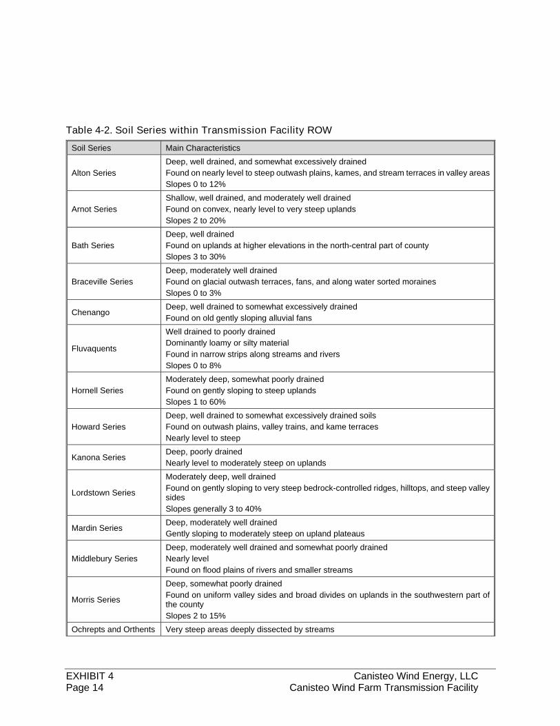
EXHIBIT 4 Canisteo Wind Energy, LLC Page 14 Canisteo Wind Farm Transmission Facility
Table 4-2. Soil Series within Transmission Facility ROW
Soil Series Main Characteristics
Alton Series
Deep, well drained, and somewhat excessively drained
Found on nearly level to steep outwash plains, kames, and stream terraces in valley areas
Slopes 0 to 12%
Arnot Series
Shallow, well drained, and moderately well drained
Found on convex, nearly level to very steep uplands
Slopes 2 to 20%
Bath Series
Deep, well drained
Found on uplands at higher elevations in the north-central part of county
Slopes 3 to 30%
Braceville Series
Deep, moderately well drained
Found on glacial outwash terraces, fans, and along water sorted moraines
Slopes 0 to 3%
Chenango Deep, well drained to somewhat excessively drained
Found on old gently sloping alluvial fans
Fluvaquents
Well drained to poorly drained
Dominantly loamy or silty material
Found in narrow strips along streams and rivers
Slopes 0 to 8%
Hornell Series
Moderately deep, somewhat poorly drained
Found on gently sloping to steep uplands
Slopes 1 to 60%
Howard Series
Deep, well drained to somewhat excessively drained soils
Found on outwash plains, valley trains, and kame terraces
Nearly level to steep
Kanona Series Deep, poorly drained
Nearly level to moderately steep on uplands
Lordstown Series
Moderately deep, well drained
Found on gently sloping to very steep bedrock-controlled ridges, hilltops, and steep valley sides
Slopes generally 3 to 40%
Mardin Series Deep, moderately well drained
Gently sloping to moderately steep on upland plateaus
Middlebury Series
Deep, moderately well drained and somewhat poorly drained
Nearly level
Found on flood plains of rivers and smaller streams
Morris Series
Deep, somewhat poorly drained
Found on uniform valley sides and broad divides on uplands in the southwestern part of the county
Slopes 2 to 15%
Ochrepts and Orthents Very steep areas deeply dissected by streams
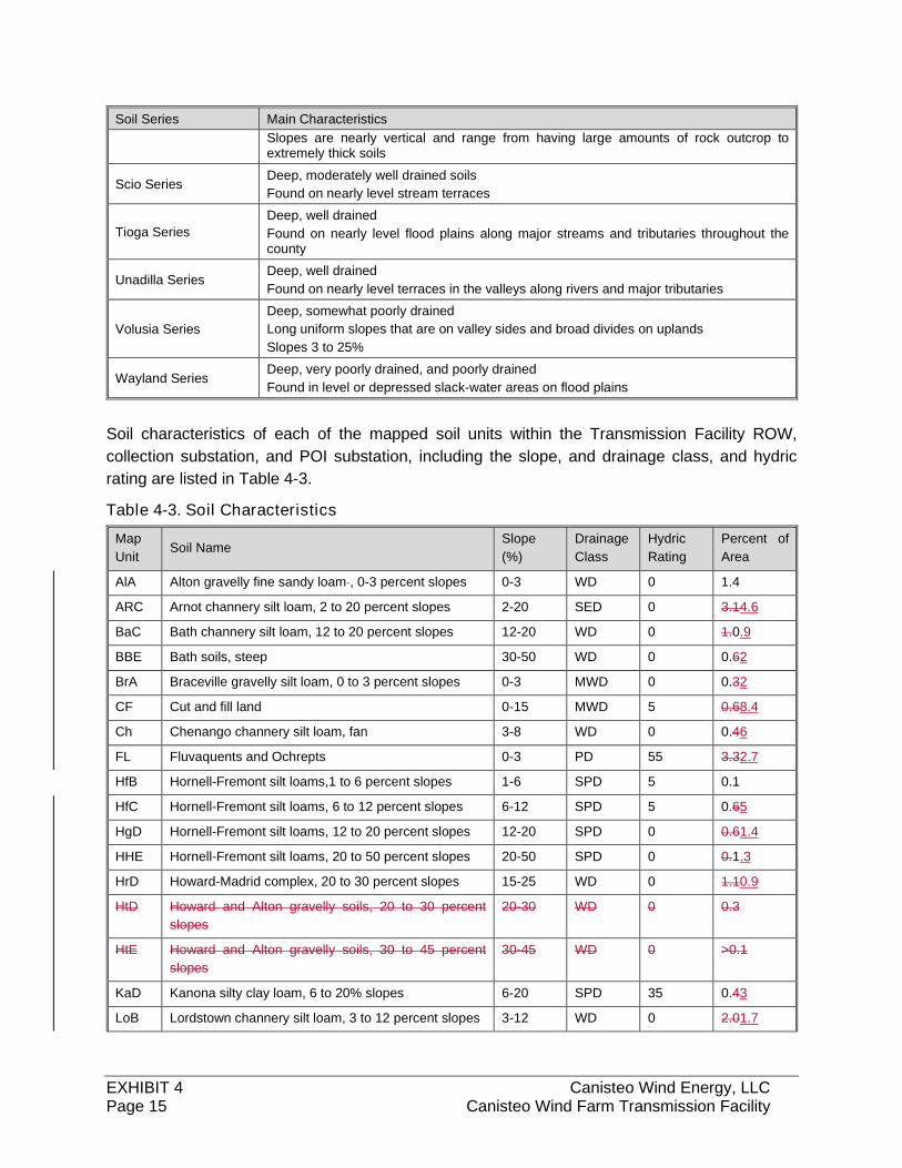
EXHIBIT 4 Canisteo Wind Energy, LLC Page 15 Canisteo Wind Farm Transmission Facility
Soil Series Main Characteristics
Slopes are nearly vertical and range from having large amounts of rock outcrop to extremely thick soils
Scio Series Deep, moderately well drained soils
Found on nearly level stream terraces
Tioga Series
Deep, well drained
Found on nearly level flood plains along major streams and tributaries throughout the county
Unadilla Series Deep, well drained
Found on nearly level terraces in the valleys along rivers and major tributaries
Volusia Series
Deep, somewhat poorly drained
Long uniform slopes that are on valley sides and broad divides on uplands
Slopes 3 to 25%
Wayland Series Deep, very poorly drained, and poorly drained
Found in level or depressed slack-water areas on flood plains
Soil characteristics of each of the mapped soil units within the Transmission Facility ROW,
collection substation, and POI substation, including the slope, and drainage class, and hydric
rating are listed in Table 4-3.
Table 4-3. Soil Characteristics
Map
Unit Soil Name
Slope
(%)
Drainage
Class
Hydric
Rating
Percent of
Area
AlA Alton gravelly fine sandy loam , 0-3 percent slopes 0-3 WD 0 1.4
ARC Arnot channery silt loam, 2 to 20 percent slopes 2-20 SED 0 3.14.6
BaC Bath channery silt loam, 12 to 20 percent slopes 12-20 WD 0 1.0.9
BBE Bath soils, steep 30-50 WD 0 0.62
BrA Braceville gravelly silt loam, 0 to 3 percent slopes 0-3 MWD 0 0.32
CF Cut and fill land 0-15 MWD 5 0.68.4
Ch Chenango channery silt loam, fan 3-8 WD 0 0.46
FL Fluvaquents and Ochrepts 0-3 PD 55 3.32.7
HfB Hornell-Fremont silt loams,1 to 6 percent slopes 1-6 SPD 5 0.1
HfC Hornell-Fremont silt loams, 6 to 12 percent slopes 6-12 SPD 5 0.65
HgD Hornell-Fremont silt loams, 12 to 20 percent slopes 12-20 SPD 0 0.61.4
HHE Hornell-Fremont silt loams, 20 to 50 percent slopes 20-50 SPD 0 0.1.3
HrD Howard-Madrid complex, 20 to 30 percent slopes 15-25 WD 0 1.10.9
HtD Howard and Alton gravelly soils, 20 to 30 percent
slopes
20-30 WD 0 0.3
HtE Howard and Alton gravelly soils, 30 to 45 percent
slopes
30-45 WD 0 >0.1
KaD Kanona silty clay loam, 6 to 20% slopes 6-20 SPD 35 0.43
LoB Lordstown channery silt loam, 3 to 12 percent slopes 3-12 WD 0 2.01.7
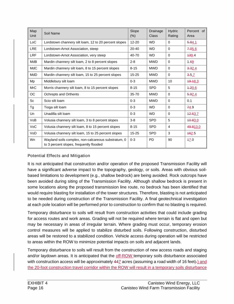
EXHIBIT 4 Canisteo Wind Energy, LLC Page 16 Canisteo Wind Farm Transmission Facility
Map
Unit Soil Name
Slope
(%)
Drainage
Class
Hydric
Rating
Percent of
Area
LoC Lordstown channery silt loam, 12 to 20 percent slopes 12-20 WD 0 5.84.1
LRE Lordstown-Arnot Association, steep 20-40 WD 0 7.05.6
LRF Lordstown-Arnot Association, very steep 40-70 WD 0 139.4
MdB Mardin channery silt loam, 2 to 8 percent slopes 2-8 MWD 0 1.69
MdC Mardin channery silt loam, 8 to 15 percent slopes 8-15 MWD 0 3.32.4
MdD Mardin channery silt loam, 15 to 25 percent slopes 15-25 MWD 0 3.5.7
Mp Middlebury silt loam 0-3 MWD 10 19.18.3
MrC Morris channery silt loam, 8 to 15 percent slopes 8-15 SPD 5 1.20.6
OC Ochrepts and Orthents 35-70 MWD 0 5.92.4
Sc Scio silt loam 0-3 MWD 0 0.1
Tg Tioga silt loam 0-3 WD 0 74.9
Un Unadilla silt loam 0-3 WD 0 12.63.7
VoB Volusia channery silt loam, 3 to 8 percent slopes 3-8 SPD 5 10.83.0
VoC Volusia channery silt loam, 8 to 15 percent slopes 8-15 SPD 4 49.813.0
VoD Volusia channery silt loam, 15 to 25 percent slopes 15-25 SPD 3 162.5
Wn Wayland soils complex, non-calcareous substratum, 0
to 3 percent slopes, frequently flooded
0-3 PD 90 17.0
Potential Effects and Mitigation
It is not anticipated that construction and/or operation of the proposed Transmission Facility will
have a significant adverse impact to the topography, geology, or soils. Areas with obvious soil-
based limitations to development (e.g., shallow bedrock) are being avoided. Rock outcrops have
been avoided during siting of the Transmission Facility. Although shallow bedrock is present in
some locations along the proposed transmission line route, no bedrock has been identified that
would require blasting for installation of the tower structures. Therefore, blasting is not anticipated
to be needed during construction of the Transmission Facility. A final geotechnical investigation
at each pole location will be performed prior to construction to confirm that no blasting is required.
Temporary disturbance to soils will result from construction activities that could include grading
for access routes and work areas. Grading will not be required where terrain is flat and open but
may be necessary in areas of irregular terrain. Where grading must occur, temporary erosion
control measures will be applied to stabilize disturbed soils. Following construction, disturbed
areas will be restored to a stabilized condition. Vehicle access during operation will be restricted
to areas within the ROW to minimize potential impacts on soils and adjacent lands.
Temporary disturbance to soils will result from the construction of new access roads and staging
and/or laydown areas. It is anticipated that the off-ROW temporary soils disturbance associated
with construction access will be approximately 447 acres (assuming a road width of 16 feet).) and
the 20-foot construction travel corridor within the ROW will result in a temporary soils disturbance
EXHIBIT 4 Canisteo Wind Energy, LLC Page 17 Canisteo Wind Farm Transmission Facility
of approximately 37 acres. Approximately 5,000 square feet of soil around the base of each tower
structure will be temporarily disturbed at the time of installation. Thus, temporary tower-related
disturbance each tower location will result in approximately 12 acres total of temporary tower-
related soil disturbance at each tower locationwithin the ROW. In wetland areas and other
sensitive sites, matting and spanning will be used to reduce temporary impacts.
Permanent disturbance will be limited to installation of new structures and any permanent access.
Permanent impacts to soils will include the creation of approximately two acres of impervious
surface for the collection substation. No permanent impacts, other than the tower foundations
themselves, are anticipated from the construction of Transmission Facility towers asbecause no
grading is anticipated.
The Best Management Practices (BMPs) to be implemented during construction may include hay
bales and silt fence barriers, stabilized construction entrances and exits, and covering stockpiled
soils. These mitigation measures will be described in detail in the EM&CPan Environmental
Management and Construction Plan and the SWPPP. Excavated soils will be used foras backfill,
asif needed, during construction of the collection substation and transmission line. If any soils to
be excavated are unsuitable for use as backfill, suitable clean fill will be used. Any excess soils
will be reused on site or properly disposed of off-site.
Vegetative Communities
Terrestrial Communities
Within the Study Area200-foot study area, existing plant communities were identified and
characterized along the proposed Transmission Facility using field data and aerial photography
obtained from Thew Associates PE-LS, PLLC. Characterization and approximate acreage of
each community were determined using the aerial photographs and GIS software. Detailed
wetland delineations were also performed and are described below in Section 4.6.2.. The
vegetative communities identified along the proposed route are depicted in Figure 4-3.
The Transmission Facility will be located within a new utility ROW that extends approximately 15
miles between the Canisteo Wind Farm to the interconnection at the existing Bennet Substation.
The proposed ROW corridor is predominately undeveloped agricultural land and woodlots. The
proposed corridor includes six vegetative communities, as well as surface waters and disturbed
or developed areas. Table 4-4 summarizes the characterization and total acreage of each
community type in the new ROW.
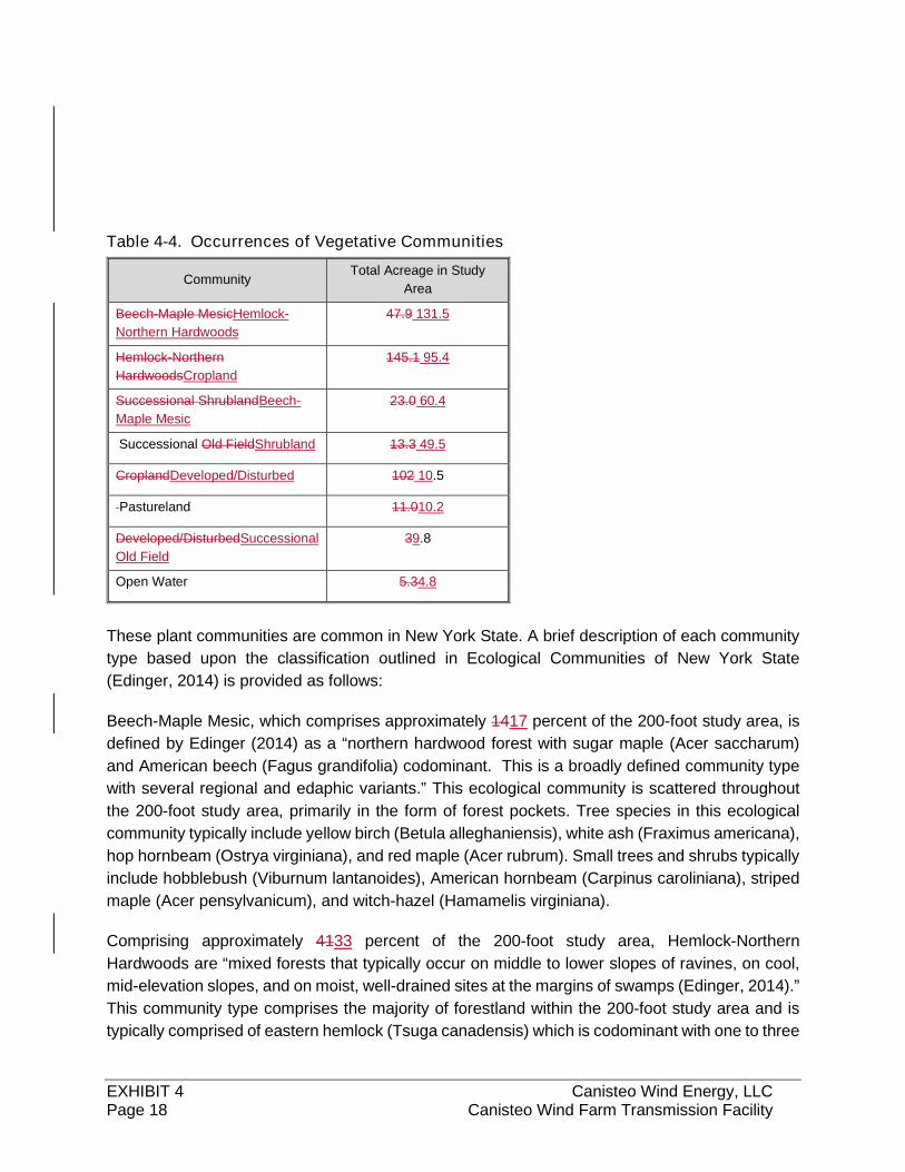
EXHIBIT 4 Canisteo Wind Energy, LLC Page 18 Canisteo Wind Farm Transmission Facility
Table 4-4. Occurrences of Vegetative Communities
Community Total Acreage in Study
Area
Beech-Maple MesicHemlock-
Northern Hardwoods
47.9 131.5
Hemlock-Northern
HardwoodsCropland
145.1 95.4
Successional ShrublandBeech-
Maple Mesic
23.0 60.4
Successional Old FieldShrubland 13.3 49.5
CroplandDeveloped/Disturbed 102 10.5
Pastureland 11.010.2
Developed/DisturbedSuccessional
Old Field
39.8
Open Water 5.34.8
These plant communities are common in New York State. A brief description of each community
type based upon the classification outlined in Ecological Communities of New York State
(Edinger, 2014) is provided as follows:
Beech-Maple Mesic, which comprises approximately 1417 percent of the 200-foot study area, is
defined by Edinger (2014) as a “northern hardwood forest with sugar maple (Acer saccharum)
and American beech (Fagus grandifolia) codominant. This is a broadly defined community type
with several regional and edaphic variants.” This ecological community is scattered throughout
the 200-foot study area, primarily in the form of forest pockets. Tree species in this ecological
community typically include yellow birch (Betula alleghaniensis), white ash (Fraximus americana),
hop hornbeam (Ostrya virginiana), and red maple (Acer rubrum). Small trees and shrubs typically
include hobblebush (Viburnum lantanoides), American hornbeam (Carpinus caroliniana), striped
maple (Acer pensylvanicum), and witch-hazel (Hamamelis virginiana).
Comprising approximately 4133 percent of the 200-foot study area, Hemlock-Northern
Hardwoods are “mixed forests that typically occur on middle to lower slopes of ravines, on cool,
mid-elevation slopes, and on moist, well-drained sites at the margins of swamps (Edinger, 2014).”
This community type comprises the majority of forestland within the 200-foot study area and is
typically comprised of eastern hemlock (Tsuga canadensis) which is codominant with one to three
EXHIBIT 4 Canisteo Wind Energy, LLC Page 19 Canisteo Wind Farm Transmission Facility
of the following species: sugar maple, red maple, yellow birch, black birch (Betula lenta), red oak
(Quercus rubra), American beech. This community type is broadly defined and widespread, with
many regional and edaphic variants.
Successional Old Field, which comprises approximately 43 percent of the 200-foot Study Area, is
defined by Edinger (2014) as “a meadow dominated by forbs and grasses that occurs on sites that
have been cleared and plowed (for farming or development), and then abandoned”. This ecological
community is found mainly in the northern portion of the 200-foot study area, primarily in the form of
field edges or reverting or abandoned agricultural fields. Herb species found in these areas include
goldenrods (Solidago spp.), bluegrasses (Poa spp.), orchard grass (Dactylis glomerata), timothy
(Phleum pratense), and quackgrass (Elymus repens). Sparse shrubs that may be present typically
include gray dogwood (Cornus foemina) and saplings from adjacent woodlots.
Comprising approximately 713 percent of the 200-foot study area, Successional Shrubland is
frequently located in association with old fields and young woodlots on the periphery of
agricultural areas. According to Edinger (2014), successional shrubland is “shrubland that
occurs on sites that have been cleared (for farming, logging, development, etc.) or otherwise
disturbed. This ecological community has at least 50 percent shrub cover and is found scattered
throughout the 200-foot study area. Characteristic shrubs include gray dogwood (Cornus
racemosa), eastern red cedar (Juniperus virginiana), and raspberries (Rubus spp.).
Pastureland, which comprises approximately 3 percent of the 200-foot study area is defined as
“agricultural land permanently maintained (or recently abandoned) as a pasture area for
livestock (Edinger, 2014).”
Cropland comprises approximately 2926 percent of the 200-foot study area and is found
scattered throughout the area. The cropland is a mix of field crops and row crops, with the
valleys and low-lying agricultural areas dominated by row crops such as corn and soybeans.
The remaining 3 percent of the 200-foot study area is either disturbed or developed land (such
as paved surfaces, roadways, or residential neighborhoods) or open water.
Aquatic Communities
Wetlands and other surface waters occur within the study area and generally include emergent
wetland, scrub-shrub wetland, forested wetland, open water, riverine upper perennial, riverine
intermittent, and riverine ephemeral. WetlandDelineated features accounted for approximately 84
percent of the 200-foot study area. A detailed delineation of wetlands and surface waters was
performed along the proposed right-of-wayROW. The results of the delineation are provided
comprehensively in below in Wetlands and Hydrology and in Appendix 4e.
Environmental Effects and Mitigation
There will be temporary and permanent impacts to terrestrial plant communities resulting from the
construction and operation of the Transmission Facility. Areas associated with the collection
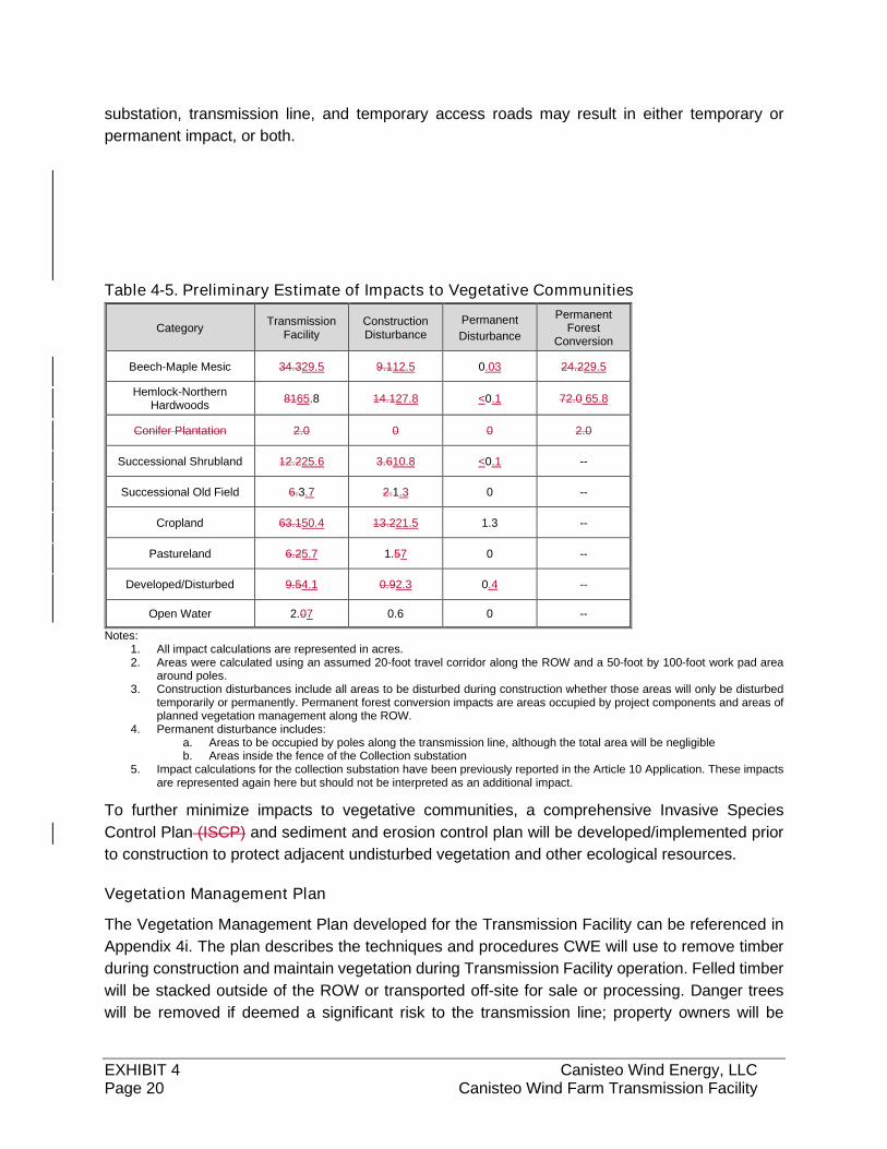
EXHIBIT 4 Canisteo Wind Energy, LLC Page 20 Canisteo Wind Farm Transmission Facility
substation, transmission line, and temporary access roads may result in either temporary or
permanent impact, or both.
Table 4-5. Preliminary Estimate of Impacts to Vegetative Communities
Category Transmission
Facility Construction Disturbance
Permanent
Disturbance
Permanent Forest
Conversion
Beech-Maple Mesic 34.329.5 9.112.5 0.03 24.229.5
Hemlock-Northern Hardwoods
8165.8 14.127.8 <0.1 72.0 65.8
Conifer Plantation 2.0 0 0 2.0
Successional Shrubland 12.225.6 3.610.8 <0.1 --
Successional Old Field 6.3.7 2.1.3 0 --
Cropland 63.150.4 13.221.5 1.3 --
Pastureland 6.25.7 1.57 0 --
Developed/Disturbed 9.54.1 0.92.3 0.4 --
Open Water 2.07 0.6 0 --
Notes: 1. All impact calculations are represented in acres. 2. Areas were calculated using an assumed 20-foot travel corridor along the ROW and a 50-foot by 100-foot work pad area
around poles. 3. Construction disturbances include all areas to be disturbed during construction whether those areas will only be disturbed
temporarily or permanently. Permanent forest conversion impacts are areas occupied by project components and areas of planned vegetation management along the ROW.
4. Permanent disturbance includes: a. Areas to be occupied by poles along the transmission line, although the total area will be negligible b. Areas inside the fence of the Collection substation
5. Impact calculations for the collection substation have been previously reported in the Article 10 Application. These impacts are represented again here but should not be interpreted as an additional impact.
To further minimize impacts to vegetative communities, a comprehensive Invasive Species
Control Plan (ISCP) and sediment and erosion control plan will be developed/implemented prior
to construction to protect adjacent undisturbed vegetation and other ecological resources.
Vegetation Management Plan
The Vegetation Management Plan developed for the Transmission Facility can be referenced in
Appendix 4i. The plan describes the techniques and procedures CWE will use to remove timber
during construction and maintain vegetation during Transmission Facility operation. Felled timber
will be stacked outside of the ROW or transported off-site for sale or processing. Danger trees
will be removed if deemed a significant risk to the transmission line; property owners will be
EXHIBIT 4 Canisteo Wind Energy, LLC Page 21 Canisteo Wind Farm Transmission Facility
notified of tree removal activities. Trees and shrubs within the ROW will be maintained to not
exceed heights of 25 feet. Vegetation within the “wire zone” (as defined in Appendix 4i) will be
managed to promote low-growing plant communities, including grasses, herbs, and small shrubs
under 3-feet tall. Access points and roads will be maintained to ensure a cleared shoulder of 2
feet, and to clear low-hanging branches and brush. CWE plans to periodically use herbicides or
mechanical means to clear areas within the collection substation fence; the POI substation will be
maintained by NYSEG. Vegetation management activities are anticipated to take place once
yearly, with some activities, such as mowing of road shoulders, taking place more often.
Fish and Wildlife Resources
Existing Environment
Fish and wildlife resources in the vicinity of the proposed Transmission Facility were determined
based on information included in the New York State Breeding Bird Atlas (New York State BBA,
2000), the New York State Amphibian and Reptile Atlas, NYSDEC Fish Atlas Maps of New York,
and other publications. The information was supplemented through correspondence with the New
York Natural Heritage Program (NYNHP), online consultation with the USFWS Information,
Planning, and Conservation System (IPaC) website to determine the potential presence of state
or federally listed endangered, threatened, or state designated species of special concern. In
addition, wildlife occurrence and potential wildlife habitat were observed and documented during
field observation and assessment of existing habitat conducted during 2017-2018. Wildlife
observation in the area also took place during avian surveys designed for reports associated with
the Article 10 Application for CWE.
Wildlife Species
Birds and Other Avian Species
The New York State Breeding Bird Atlas (BBA) is a comprehensive, statewide survey that
indicates the distribution of breeding birds in New York State. Point counts are conducted by
volunteers within 5-kilometer by 5-kilometer survey blocks across the state (McGowan & Corwin,
2008). The Transmission Facility is located within six survey blocks (2768B, 2768D, 2868C,
2867A, 2867C, and 2866A). The BBA has documented the presence of 106 breeding bird species
in the six survey blocks. Common breeding species include American robin (Turdus migratorius),
gray catbird (Dumetella carolinensis), blue jay (Cyanocitta cristata), black-capped chickadee
(Poecile atriapillus), and red-tailed hawk (Buteo jamaicensis). Of the bird species identified by the
BBA in the vicinity of the Transmission Facility, none were listed by the U.S. Fish and Wildlife
Service (USFWS) or the NYSDEC as endangered. One species, the northern harrier (Circus
cyaneus), is a state-listed threatened species, and six species, the cerulean warbler (Dendroica
cerulea), Cooper’s hawk (Accipiter cooperii), grasshopper sparrow (Ammondramus savannarum),
horned lark (Eremophila alpestris), sharp-shinned hawk (Accipiter striatus), and vesper sparrow
(Pooecetes gramineus), are state-listed as species of special concern.
EXHIBIT 4 Canisteo Wind Energy, LLC Page 22 Canisteo Wind Farm Transmission Facility
There are no designated Important Bird Areas (IBAs) or Bird Conservations Areas (BCAs) in the
vicinity of the Transmission Facility. Keeney Swamp, located approximately 14 miles northwest
of the Transmission Facility in Allegany County, is the closest IBA and BCA to the Transmission
Facility (Audubon, 2018 and NYSDEC, 2018a).
Amphibians and Reptiles
Other than the New York State Amphibian and Reptile Atlas, no existing data were available
concerning reptiles and amphibians in the area of the proposed Transmission Facility. Based on
the atlas data, species range, and existing habitat conditions, it is estimated that 23 species could
occur in the vicinity of the Transmission Facility. These species include green frog (Rana
clamitans), American toad (Bufo americanus), spotted salamander (Ambystoma maculatum),
painted turtle (Chrysemys picta), and common gartersnake (Thamnophis sirtalis). No listed
endangered, threatened, or special concern species of reptile or amphibian were identified by the
atlas.
Mammals
Publicly available information regarding the occurrence of mammalian species in the vicinity of
the Transmission Facility is generally not available. Therefore, mammal occurrence was
documented through species observations made during on-site field surveys. Mammals expected
to be present in the vicinity of the Transmission Facility based on available habitat and wide
occurrence throughout New York State include common porcupine (Erethizon dorsatum), striped
skunk (Mephitis mephitis), white-tailed deer (Odocoileus virginianus), mink (Neovison vison),
coyote (Canis latrans), black bear (Ursus americanus), bobcat (Lynx rufus), American beaver
(Castor canadensis), eastern chipmunk (Tamias striatus), and eastern cottontail (Sylvilagus
floridanus). In addition, a variety of mice, voles, shrews, and moles are expected to use the
Facility. Of all the mammal species likely to occur on site, the northern long-eared bat (Myotis
septentrionalis) is the only one listed by the U.S. Fish and Wildlife Service as threatened and the
NYSDEC as endangered. A discussion of this and other listed species that could be present in
the area is presented below under the heading Threatened and Endangered Species.
Fish and Benthic Communities
The proposed route intersects several perennial streams that support fish populations. Data were
retrieved from Version 45 of the NYSDEC Statewide Fisheries Database via a site-specific
request to the Region 8 office of the NYSDEC. The following streams were queried for a list of
fish species documented to live in those streams: Cunningham Creek, Hammer Creek, Bennetts
Creek, Canisteo River, Colonel Bills Creek, Two Bridge Run, and Red Spring Run. A total of 27
species have been documented within these streams by the NYSDEC. Common species include
common shiner (Luxilus cornutus), creek chub (Semotilus atromaculatus), eastern blacknose
dace (Rhinichthys atratulus), and longnose dace (Rhinichthys cataractae). Two trout streams,
Bennetts Creek and Canisteo Creek support a coldwater fish community including brook trout
(Salvelinus fontinalis), brown trout (Salmo trutta), creek chub, and mottled sculpin (Cottus bairdii).
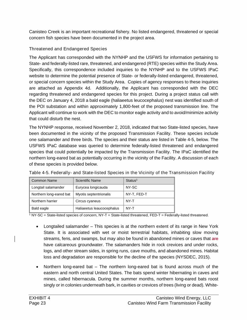
EXHIBIT 4 Canisteo Wind Energy, LLC Page 23 Canisteo Wind Farm Transmission Facility
Canisteo Creek is an important recreational fishery. No listed endangered, threatened or special
concern fish species have been documented in the project area.
Threatened and Endangered Species
The Applicant has corresponded with the NYNHP and the USFWS for information pertaining to
State- and federally-listed rare, threatened, and endangered (RTE) species within the Study Area.
Specifically, this correspondence included inquiries to the NYNHP and to the USFWS IPaC
website to determine the potential presence of State- or federally-listed endangered, threatened,
or special concern species within the Study Area. Copies of agency responses to these inquiries
are attached as Appendix 4d. Additionally, the Applicant has corresponded with the DEC
regarding threatened and endangered species for this project. During a project status call with
the DEC on January 4, 2018 a bald eagle (haliaeetus leucocephalus) nest was identified south of
the POI substation and within approximately 1,800-feet of the proposed transmission line. The
Applicant will continue to work with the DEC to monitor eagle activity and to avoid/minimize activity
that could disturb the nest.
The NYNHP response, received November 2, 2018, indicated that two State-listed species, have
been documented in the vicinity of the proposed Transmission Facility. These species include
one salamander and three birds. The species and their status are listed in Table 4-5, below. The
USFWS IPaC database was queried to determine federally-listed threatened and endangered
species that could potentially be impacted by the Transmission Facility. The IPaC identified the
northern long-eared bat as potentially occurring in the vicinity of the Facility. A discussion of each
of these species is provided below.
Table 4-5. Federally- and State-listed Species in the Vicinity of the Transmission Facility
Common Name Scientific Name Status1
Longtail salamander Eurycea longicauda NY-SC
Northern long-eared bat Myotis septentrionalis NY-T, FED-T
Northern harrier Circus cyaneus NY-T
Bald eagle Haliaeetus leaucocephalus NY-T
1 NY-SC = State-listed species of concern, NY-T = State-listed threatened, FED-T = Federally-listed threatened.
Longtailed salamander – This species is at the northern extent of its range in New York
State. It is associated with wet or moist terrestrial habitats, inhabiting slow moving
streams, fens, and swamps, but may also be found in abandoned mines or caves that are
have calcareous groundwater. The salamanders hide in rock crevices and under rocks,
logs, and other stream sides, in spring runs, cave mouths, and abandoned mines. Habitat
loss and degradation are responsible for the decline of the species (NYSDEC, 2015).
Northern long-eared bat – The northern long-eared bat is found across much of the
eastern and north central United States. The bats spend winter hibernating in caves and
mines, called hibernacula. During the summer months, northern long-eared bats roost
singly or in colonies underneath bark, in cavities or crevices of trees (living or dead). White-
EXHIBIT 4 Canisteo Wind Energy, LLC Page 24 Canisteo Wind Farm Transmission Facility
nose syndrome, a fungal disease, is the predominant threat to this species. Since white-
nose syndrome was discovered in New York in 2006, numbers of northern long-eared bats
have declined by up to 99% (USFWS, 2015).
Northern harrier – The northern harrier is a slim, medium-sized hawk with long broad wings
and long legs and tail that are found in New York in the Great Lakes plain, open habitats
of the Adirondacks, western Finger Lakes, Long Island, and the Hudson, Saint Lawrence,
and Lake Champlain valleys (NYNHP, 2018). This species uses a wide range of open
grasslands, shrubland, and salt and freshwater marshes. They nest on the ground, usually
in dense cover. The loss of suitable grassland habitats is the most significant threat to
northern harrier populations in New York.
Bald eagle- The bald eagle is one of the largest birds of prey of prey in North America with
a wingspan of nearly six feet. Bald eagles exist throughout North America and are typically
found in undisturbed areas near large bodies of water, marshes, swamps, and rivers
where fish and waterfowl populations are plentiful. They nest in forested areas in tall
deciduous or coniferous trees, and usually return to the same general area for nesting
each year. Threats to this species include bioaccumulation of contaminants in the food
web, habitat destruction and forest fragmentation due to human development, and
collisions with vehicles, towers, aand utilities (NYNHP, 2017).
Environmental Effects and Mitigation
In general, impacts to fish and wildlife will be limited due to the proposed routing of the
transmission line and the location of towers and access roads. A large portion of the Transmission
Facility route traverses or borders open agricultural land where impacts to wildlife are minimal.
Clearing of forestland will also occur within large portions of the ROW. Along with direct loss of
(and damage to) vegetation, these impacts can result in a loss of wildlife food and cover. However,
the acreage impacted is minor considering the available forest habitat that will be remaining.
Construction and operation of the proposed Transmission Facility may result in some unavoidable
impacts to wildlife. Direct impacts of the proposed Transmission Facility on wildlife resources
could include the following:
Incidental injury and mortality due to construction activity and vehicle movements,
Minor temporary habitat disturbance during construction, and
Temporary disturbance of wildlife due to increased noise and human activity during
construction.
Incidental injury and mortality should be limited to sedentary and slow-moving species that are
unable to relocate from disturbed areas during construction (e.g., salamanders, toads, etc.). More
mobile species should be able to vacate the areas that will be disturbed. Direct loss of wildlife will
EXHIBIT 4 Canisteo Wind Energy, LLC Page 25 Canisteo Wind Farm Transmission Facility
also be minimized by avoiding disturbance of forest to the extent practicable, avoiding impacts to
streams and wetlands, and utilizing the existing cleared ROW for Transmission Facility access.
Most of the potential impacts to wildlife will be minor and/or temporary. Once construction has
been completed, species displaced or disturbed by the increased noise and human activity are
expected to return to the area. The Transmission Facility will be built in accordance with the
Applicant’s BMPs addressing vegetative clearing and disposal, invasive species management,
sediment and erosion control measures, and wetland protection.
To avoid potential impacts to roosting northern long-eared bats, clearing of trees and shrubs
greater than 3 inches diameter at breast height (dbh) is anticipated to be restricted to the period
between November 1 and March 31, when the bats are hibernating off-site. If work is required
outside this winter clearing period the Applicant will follow the USFWS 4d rule and the NYSDEC
guidance1. This includes no cutting of any trees within 1/4 mile buffer of a hibernaculum. For
cutting of trees outside of the ¼ mile buffer around hibernacula or within 1.5 miles of a summer
occurrence, snag and cavity trees will remain uncut unless their removal is necessary for
protection of human life and property. Additionally, any documented roost trees and any trees
within a 150-foot radius of a documents summer occurrence will remain uncut.
Consultation with the NYSDEC indicated that there is a documented northern harrier breeding
record in an open hayfield near two proposed pole locations. The NYSDEC provides best
management practices (BMPs) for grassland bird species that are a high priority for protection
and management. Since the northern harrier is listed as threatened in NYS, the Applicant will
work with the DECNYSDEC to identify BMPS to avoid potential impact to these species. BMPs
that may be implemented include no mowing, planting, harvesting, driving, or any other
mechanized means during the nesting season (April 23 to August 15). Following these BMPs will
limit impacts to northern harriers. No long-term impacts to this species are expected.
Wetlands and Hydrology
The following section discusses the characteristics of the surface water and groundwater features,
and wetlands located within the Study Area. Data sources used in this evaluation include existing
agency information, USGS topographic maps, New York State Department of Health (NYSDOH)
aquifer mapping, NYSDEC Freshwater Wetland Maps, USFWS National Wetland Inventory
maps, NYSDEC Waterbody Classification Maps, aerial photographs, reconnaissance level field
verification, and an on-site wetland delineation performed in accordance with the 1987 Corps of
Engineers Wetland Delineation Manual (Environmental Laboratory, 1987). The wetland study
area consists of a 200-foot corridor along the ROW for the Transmission Facility,transmission
line and at the collection substation.
1 https://www.dec.ny.gov/animals/106090.html
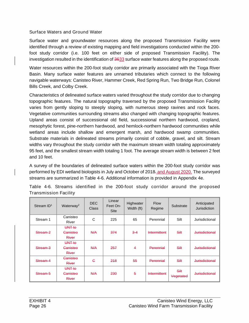
EXHIBIT 4 Canisteo Wind Energy, LLC Page 26 Canisteo Wind Farm Transmission Facility
Surface Waters and Ground Water
Surface water and groundwater resources along the proposed Transmission Facility were
identified through a review of existing mapping and field investigations conducted within the 200-
foot study corridor (i.e. 100 feet on either side of proposed Transmission Facility). The
investigation resulted in the identification of 3633 surface water features along the proposed route.
Water resources within the 200-foot study corridor are primarily associated with the Tioga River
Basin. Many surface water features are unnamed tributaries which connect to the following
navigable waterways: Canisteo River, Hammer Creek, Red Spring Run, Two Bridge Run, Colonel
Bills Creek, and Colby Creek.
Characteristics of delineated surface waters varied throughout the study corridor due to changing
topographic features. The natural topography traversed by the proposed Transmission Facility
varies from gently sloping to steeply sloping, with numerous steep ravines and rock faces.
Vegetative communities surrounding streams also changed with changing topographic features.
Upland areas consist of successional old field, successional northern hardwood, cropland,
mesophytic forest, pine-northern hardwood, and hemlock-northern hardwood communities while
wetland areas include shallow and emergent marsh, and hardwood swamp communities.
Substrate materials in delineated streams primarily consist of cobble, gravel, and silt. Stream
widths vary throughout the study corridor with the maximum stream width totaling approximately
95 feet, and the smallest stream width totaling 1 foot. The average stream width is between 2 feet
and 10 feet.
A survey of the boundaries of delineated surface waters within the 200-foot study corridor was
performed by EDI wetland biologists in July and October of 2018. and August 2020. The surveyed
streams are summarized in Table 4-6. Additional information is provided in Appendix 4e.
Table 4-6. Streams identified in the 200-foot study corridor around the proposed
Transmission Facility
Stream ID1 Waterway2 DEC
Class
Linear
Feet On-
Site
Highwater
Width (ft)
Flow
Regime Substrate
Anticipated
Jurisdiction
Stream 1 Canisteo
River C 225 65 Perennial Silt Jurisdictional
Stream 2
UNT to
Canisteo
River
N/A 374 3-4 Intermittent Silt Jurisdictional
Stream 3
UNT to
Canisteo
River
N/A 257 4 Perennial Silt Jurisdictional
Stream 4 Canisteo
River C 218 55 Perennial Silt Jurisdictional
Stream 5
UNT to
Canisteo
River
N/A 230 5 Intermittent Silt
Vegetated Jurisdictional
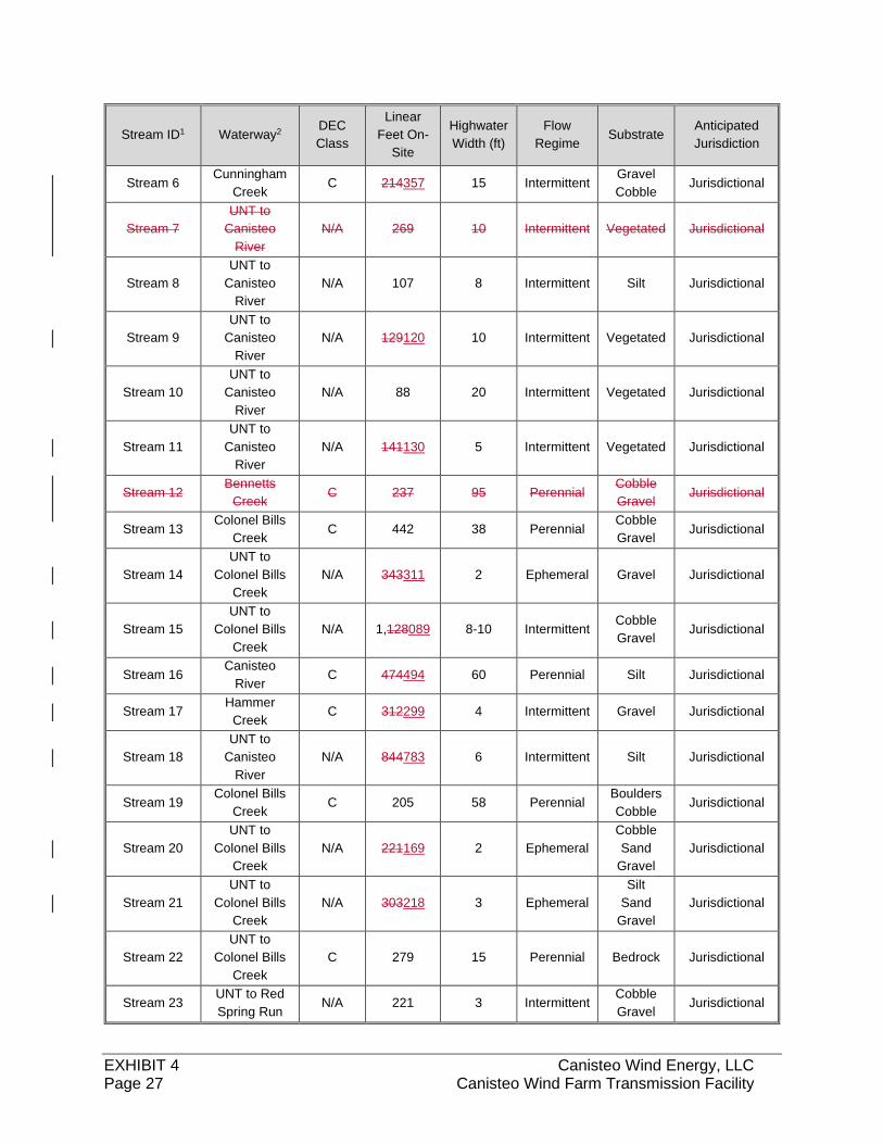
EXHIBIT 4 Canisteo Wind Energy, LLC Page 27 Canisteo Wind Farm Transmission Facility
Stream ID1 Waterway2 DEC
Class
Linear
Feet On-
Site
Highwater
Width (ft)
Flow
Regime Substrate
Anticipated
Jurisdiction
Stream 6 Cunningham
Creek C 214357 15 Intermittent
Gravel
Cobble Jurisdictional
Stream 7
UNT to
Canisteo
River
N/A 269 10 Intermittent Vegetated Jurisdictional
Stream 8
UNT to
Canisteo
River
N/A 107 8 Intermittent Silt Jurisdictional
Stream 9
UNT to
Canisteo
River
N/A 129120 10 Intermittent Vegetated Jurisdictional
Stream 10
UNT to
Canisteo
River
N/A 88 20 Intermittent Vegetated Jurisdictional
Stream 11
UNT to
Canisteo
River
N/A 141130 5 Intermittent Vegetated Jurisdictional
Stream 12 Bennetts
Creek C 237 95 Perennial
Cobble
Gravel Jurisdictional
Stream 13 Colonel Bills
Creek C 442 38 Perennial
Cobble
Gravel Jurisdictional
Stream 14
UNT to
Colonel Bills
Creek
N/A 343311 2 Ephemeral Gravel Jurisdictional
Stream 15
UNT to
Colonel Bills
Creek
N/A 1,128089 8-10 Intermittent Cobble
Gravel Jurisdictional
Stream 16 Canisteo
River C 474494 60 Perennial Silt Jurisdictional
Stream 17 Hammer
Creek C 312299 4 Intermittent Gravel Jurisdictional
Stream 18
UNT to
Canisteo
River
N/A 844783 6 Intermittent Silt Jurisdictional
Stream 19 Colonel Bills
Creek C 205 58 Perennial
Boulders
Cobble Jurisdictional
Stream 20
UNT to
Colonel Bills
Creek
N/A 221169 2 Ephemeral
Cobble
Sand
Gravel
Jurisdictional
Stream 21
UNT to
Colonel Bills
Creek
N/A 303218 3 Ephemeral
Silt
Sand
Gravel
Jurisdictional
Stream 22
UNT to
Colonel Bills
Creek
C 279 15 Perennial Bedrock Jurisdictional
Stream 23 UNT to Red
Spring Run N/A 221 3 Intermittent
Cobble
Gravel Jurisdictional
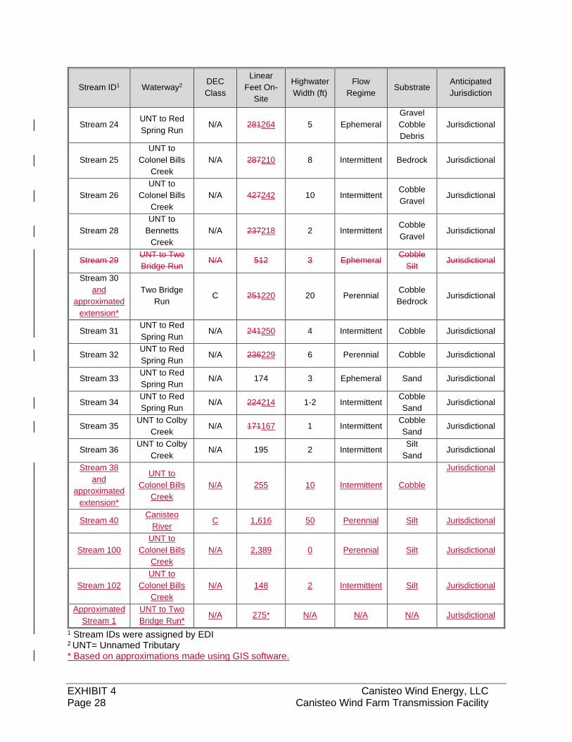
EXHIBIT 4 Canisteo Wind Energy, LLC Page 28 Canisteo Wind Farm Transmission Facility
Stream ID1 Waterway2 DEC
Class
Linear
Feet On-
Site
Highwater
Width (ft)
Flow
Regime Substrate
Anticipated
Jurisdiction
Stream 24 UNT to Red
Spring Run N/A 281264 5 Ephemeral
Gravel
Cobble
Debris
Jurisdictional
Stream 25
UNT to
Colonel Bills
Creek
N/A 287210 8 Intermittent Bedrock Jurisdictional
Stream 26
UNT to
Colonel Bills
Creek
N/A 427242 10 Intermittent Cobble
Gravel Jurisdictional
Stream 28
UNT to
Bennetts
Creek
N/A 237218 2 Intermittent Cobble
Gravel Jurisdictional
Stream 29 UNT to Two
Bridge Run N/A 512 3 Ephemeral
Cobble
Silt Jurisdictional
Stream 30
and
approximated
extension*
Two Bridge
Run C 251220 20 Perennial
Cobble
Bedrock Jurisdictional
Stream 31 UNT to Red
Spring Run N/A 241250 4 Intermittent Cobble Jurisdictional
Stream 32 UNT to Red
Spring Run N/A 236229 6 Perennial Cobble Jurisdictional
Stream 33 UNT to Red
Spring Run N/A 174 3 Ephemeral Sand Jurisdictional
Stream 34 UNT to Red
Spring Run N/A 224214 1-2 Intermittent
Cobble
Sand Jurisdictional
Stream 35 UNT to Colby
Creek N/A 171167 1 Intermittent
Cobble
Sand Jurisdictional
Stream 36 UNT to Colby
Creek N/A 195 2 Intermittent
Silt
Sand Jurisdictional
Stream 38
and
approximated
extension*
UNT to
Colonel Bills
Creek
N/A 255 10 Intermittent Cobble
Jurisdictional
Stream 40 Canisteo
River C 1,616 50 Perennial Silt Jurisdictional
Stream 100
UNT to
Colonel Bills
Creek
N/A 2,389 0 Perennial Silt Jurisdictional
Stream 102
UNT to
Colonel Bills
Creek
N/A 148 2 Intermittent Silt Jurisdictional
Approximated
Stream 1
UNT to Two
Bridge Run* N/A 275* N/A N/A N/A Jurisdictional
1 Stream IDs were assigned by EDI 2 UNT= Unnamed Tributary * Based on approximations made using GIS software.
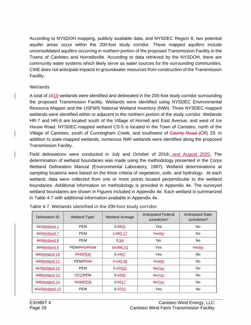
EXHIBIT 4 Canisteo Wind Energy, LLC Page 29 Canisteo Wind Farm Transmission Facility
According to NYSDOH mapping, publicly available data, and NYSDEC Region 8, two potential
aquifer areas occur within the 200-foot study corridor. These mapped aquifers include
unconsolidated aquifers occurring in northern portion of the proposed Transmission Facility in the
Towns of Canisteo and Hornellsville. According to data retrieved by the NYSDOH, there are
community water systems which likely serve as water sources for the surrounding communities.
CWE does not anticipate impacts to groundwater resources from construction of the Transmission
Facility.
Wetlands
A total of 1519 wetlands were identified and delineated in the 200-foot study corridor surrounding
the proposed Transmission Facility. Wetlands were identified using NYSDEC Environmental
Resource Mapper and the USFWS National Wetland Inventory (NWI). Three NYSDEC-mapped
wetlands were identified within or adjacent to the northern portion of the study corridor. Wetlands
HR-7 and HR-8 are located south of the Village of Hornell and East Avenue, and west of Ice
House Road. NYSDEC-mapped wetland CS-5 is located in the Town of Canisteo, north of the
Village of Canisteo, south of Cunningham Creek, and southwest of County Road (CR) 29. In
addition to state-mapped wetlands, numerous NWI wetlands were identified along the proposed
Transmission Facility.
Field delineations were conducted in July and October of 2018. and August 2020. The
determination of wetland boundaries was made using the methodology presented in the Corps
Wetland Delineation Manual (Environmental Laboratory, 1987). Wetland determinations at
sampling locations were based on the three criteria of vegetation, soils, and hydrology. At each
wetland, data were collected from one or more points located perpendicular to the wetland
boundaries. Additional information on methodology is provided in Appendix 4e. The surveyed
wetland boundaries are shown in Figures included in Appendix 4e. Each wetland is summarized
in Table 4-7 with additional information available in Appendix 4e.
Table 4-7. Wetlands identified in the 200-foot study corridor
Delineation ID Wetland Type1 Wetland Acreage Anticipated Federal
Jurisdiction2
Anticipated State
Jurisdiction3
W1Wetland 1 PEM 0.6655 Yes No
W2Wetland 7 PEM 1.650.17 YesNo No
W3Wetland 8 PEM 0.54 No No
W4Wetland 9 PEM/PFO/POW 19.890.01 Yes YesNo
W5Wetland 10 PFOPEM 0.4407 Yes No
W6Wetland 11 PEM/POW 2.140.08 YesNo No
W7Wetland 12 PEM 0.27022 NoYes No
W8Wetland 13 PFO/PEM 0.5245 NoYes No
W9Wetland 14 POWPEM 0.0217 NoYes No
W10Wetland 15 PEM 0.0703 Yes No
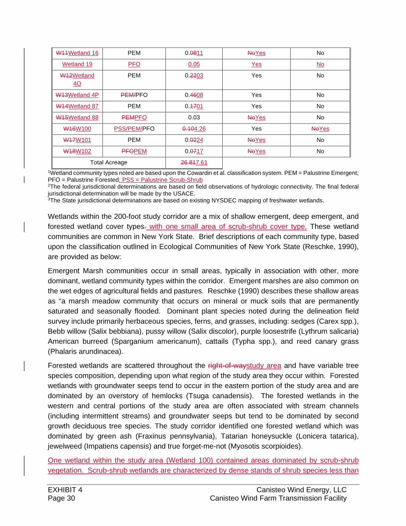
EXHIBIT 4 Canisteo Wind Energy, LLC Page 30 Canisteo Wind Farm Transmission Facility
W11Wetland 16 PEM 0.0811 NoYes No
Wetland 19 PFO 0.05 Yes No
W12Wetland
4O
PEM 0.2203 Yes No
W13Wetland 4P PEM/PFO 0.4608 Yes No
W14Wetland 87 PEM 0.1701 Yes No
W15Wetland 88 PEMPFO 0.03 NoYes No
W16W100 PSS/PEM/PFO 0.104.26 Yes NoYes
W17W101 PEM 0.0224 NoYes No
W18W102 PFOPEM 0.0717 NoYes No
Total Acreage 26.817.61
1Wetland community types noted are based upon the Cowardin et al. classification system. PEM = Palustrine Emergent; PFO = Palustrine Forested; PSS = Palustrine Scrub-Shrub2The federal jurisdictional determinations are based on field observations of hydrologic connectivity. The final federal jurisdictional determination will be made by the USACE. 3The State jurisdictional determinations are based on existing NYSDEC mapping of freshwater wetlands.
Wetlands within the 200-foot study corridor are a mix of shallow emergent, deep emergent, and
forested wetland cover types. with one small area of scrub-shrub cover type. These wetland
communities are common in New York State. Brief descriptions of each community type, based
upon the classification outlined in Ecological Communities of New York State (Reschke, 1990),
are provided as below:
Emergent Marsh communities occur in small areas, typically in association with other, more
dominant, wetland community types within the corridor. Emergent marshes are also common on
the wet edges of agricultural fields and pastures. Reschke (1990) describes these shallow areas
as “a marsh meadow community that occurs on mineral or muck soils that are permanently
saturated and seasonally flooded. Dominant plant species noted during the delineation field
survey include primarily herbaceous species, ferns, and grasses, including: sedges (Carex spp.),
Bebb willow (Salix bebbiana), pussy willow (Salix discolor), purple loosestrife (Lythrum salicaria)
American burreed (Sparganium americanum), cattails (Typha spp.), and reed canary grass
(Phalaris arundinacea).
Forested wetlands are scattered throughout the right-of-waystudy area and have variable tree
species composition, depending upon what region of the study area they occur within. Forested
wetlands with groundwater seeps tend to occur in the eastern portion of the study area and are
dominated by an overstory of hemlocks (Tsuga canadensis). The forested wetlands in the
western and central portions of the study area are often associated with stream channels
(including intermittent streams) and groundwater seeps but tend to be dominated by second
growth deciduous tree species. The study corridor identified one forested wetland which was
dominated by green ash (Fraxinus pennsylvania), Tatarian honeysuckle (Lonicera tatarica),
jewelweed (Impatiens capensis) and true forget-me-not (Myosotis scorpioides).
One wetland within the study area (Wetland 100) contained areas dominated by scrub-shrub
vegetation. Scrub-shrub wetlands are characterized by dense stands of shrub species less than
EXHIBIT 4 Canisteo Wind Energy, LLC Page 31 Canisteo Wind Farm Transmission Facility
20 feet tall. This area was part of a larger wetland complex with multiple cover types that included
PEM and PFO wetlands.
Environmental Effects and Mitigation
Streams and waterbodies
Stream impacts will be limited by keeping soil removal and distribution to a minimum and
employing a comprehensive erosion and sediment control program. The direct impacts of stream
crossings will be minimized by utilizing existing crossing locations whenever possible. It is
anticipated that all stream crossings will temporary and that timber mats will be used rather than
culverts (see Appendix 4k). Armoring of existing ford crossings will have a long-term beneficial
effect on water quality. Special crossing techniques, equipment restrictions, herbicide use
restrictions and erosion and sedimentation control measures will be utilized to reduce impacts to
water quality, surface water hydrology and aquatic organisms.
Although some clearing of tall – growing trees will be required at several proposed stream
crossings, including ravine areas in the middle portion of the line. Permanent impacts to streams
will be reduced or eliminated to the extent practicable by the following measures: 1) noone tower
structuresstructure will be located where the area of disturbance for installation will may disturb
the bed or bank of a stream,two streams (Stream 100 and Stream 102), 2) of the 3733 streams
that occur in the study area, access road crossings at approximately 14 streams 4 stream
crossings will be avoided through dead ending and the use of off-right-of-wayROW access roads
(see Figure 2-4-3; and 3) of the 2331 stream crossings by proposed access roadsrequired during
construction, all will be temporary. No permanent disturbances to the banks of protected streams
is anticipated.
New access roads, where needed, will minimize impacts to stream through installation of
temporary crossing roads. Access roads will not exceed 16 feet in width. Site specific locations of
access roads across streams within the right-of-wayROW have not been finalized. Final
construction drawings will be prepared and will provide additional information regarding the type
and location of stream crossings within the Transmission Facility study area. Stream impacts
resulting from the construction of off-right-of-wayROW access roads will be limited, as these have
been sited to avoid additional stream crossings or utilizing existing crossings.
Wetlands
Indirect impacts to wetland water quality and vegetation will occur as a result of clearing activities
and soil erosion, siltation and sedimentation from construction activities on the right-of-wayROW.
These impacts are temporary and will be minimized through appropriate construction practices.
Permanent impacts to wetlands will occur as a result of access road construction through certain
areas (e.g. forested wetlands) and through placement of poles. Potential impacts associated with
access road crossings of wetlands include loss of fish and wildlife habitat, alteration of wetland
hydrology, degradation of water quality, and/or reduction of other wetland functions and values
(e.g. flood storage, groundwater recharge, etc.). To reduce such impacts, wetland areas have
been avoided to the extent practicable during the siting of the transmission line route and all
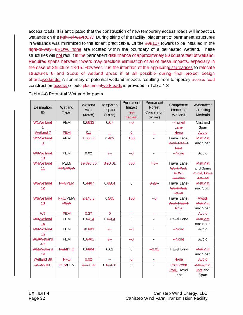
EXHIBIT 4 Canisteo Wind Energy, LLC Page 32 Canisteo Wind Farm Transmission Facility
access roads. It is anticipated that the construction of new temporary access roads will impact 11
wetlands on the right-of-wayROW. During siting of the facility, placement of permanent structures
in wetlands was minimized to the extent practicable. Of the 108107 towers to be installed in the
right-of-way, 8ROW, none are located within the boundary of a delineated wetland. These
structures will not result in the permanent disturbance of approximately 80 square feet of wetland.
Required spans between towers may preclude elimination of all of these impacts, especially in
the case of Structure 13-15. However, it is the intention of the applicantdisturbances to relocate
structures 6 and 21out of wetland areas if at all possible during final project design
efforts.wetlands. A summary of potential wetland impacts resulting from temporary access road
construction access or pole placementwork pads is provided in Table 4-8.
Table 4-8 Potential Wetland Impacts
Delineation
ID
Wetland
Type1
Wetland
Area
(acres)
Temporary
Impact
(acres)
Permanent
Impact
(sq.
ftacres)
Permanent
Forest
Conversion
(acres)
Component
Impacting
Wetland
Avoidance/
Crossing
Methods
W1Wetland
1
PEM 0.6633 0.07 --0 -- --Travel
Lane
Matt and
Span
Wetland 7 PEM 0.1 -- 0 -- None Avoid
W2Wetland
8
PEM 1.650.3 0.402 100 -- Travel Lane,
Work Pad, 1
Pole
MattMat
and Span
W3Wetland
10
PEM 0.02 0-- --0 -- --None Avoid
W4Wetland
11
PEM/
PFO/POW
19.890.06 3.90.01 600 4.0-- Travel Lane,
Work Pad,
ROW,
6-Poles
MattMat
and Span,
Avoid, Drive
Around
W5Wetland
12
PFOPEM 0.4407 0.0504 0 0.23-- Travel Lane,
Work Pad,
ROW
MattMat
and Span
W6Wetland
13
PFO/PEM/
POW
2.140.3 0.505 100 --0 Travel Lane,
Work Pad, 1
Pole
Avoid,
MattMat
and Span
W7 PEM 0.27 0 -- -- -- Avoid
W8Wetland
14
PEM 0.5214 0.0204 0 -- Travel Lane MattMat
and Span
W9Wetland
16
PEM <0.021 0-- --0 -- --None Avoid
W10Wetland
4O
PEM 0.0702 0-- --0 -- --None Avoid
W11Wetland
4P
PEMPFO 0.0804 0.01 0 --0.01 Travel Lane MattMat
and Span
Wetland 88 PFO 0.02 -- 0 -- None Avoid
W12W100 PSS/PEM 0.221.92 0.02436 0 -- Pole Work
Pad, Travel
Lane
MattAvoid,
Mat and
Span
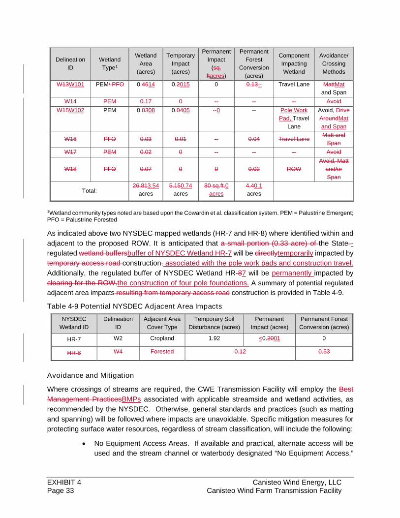
EXHIBIT 4 Canisteo Wind Energy, LLC Page 33 Canisteo Wind Farm Transmission Facility
Delineation
ID
Wetland
Type1
Wetland
Area
(acres)
Temporary
Impact
(acres)
Permanent
Impact
(sq.
ftacres)
Permanent
Forest
Conversion
(acres)
Component
Impacting
Wetland
Avoidance/
Crossing
Methods
W13W101 PEM/ PFO 0.4614 0.2015 0 0.13-- Travel Lane MattMat
and Span
W14 PEM 0.17 0 -- -- -- Avoid
W15W102 PEM 0.0308 0.0405 --0 -- Pole Work
Pad, Travel
Lane
Avoid, Drive
AroundMat
and Span
W16 PFO 0.03 0.01 -- 0.04 Travel Lane Matt and
Span
W17 PEM 0.02 0 -- -- -- Avoid
W18 PFO 0.07 0 0 0.02 ROW
Avoid, Matt
and/or
Span
Total: 26.813.54
acres
5.150.74
acres
80 sq.ft.0
acres
4.40.1
acres
1Wetland community types noted are based upon the Cowardin et al. classification system. PEM = Palustrine Emergent; PFO = Palustrine Forested
As indicated above two NYSDEC mapped wetlands (HR-7 and HR-8) where identified within and
adjacent to the proposed ROW. It is anticipated that a small portion (0.33 acre) of the State -
regulated wetland buffersbuffer of NYSDEC Wetland HR-7 will be directlytemporarily impacted by
temporary access road construction. associated with the pole work pads and construction travel.
Additionally, the regulated buffer of NYSDEC Wetland HR-87 will be permanently impacted by
clearing for the ROW.the construction of four pole foundations. A summary of potential regulated
adjacent area impacts resulting from temporary access road construction is provided in Table 4-9.
Table 4-9 Potential NYSDEC Adjacent Area Impacts
NYSDEC
Wetland ID
Delineation
ID
Adjacent Area
Cover Type
Temporary Soil
Disturbance (acres)
Permanent
Impact (acres)
Permanent Forest
Conversion (acres)
HR-7 W2 Cropland 1.92 <0.2001 0
HR-8 W4 Forested 0.12 0.53
Avoidance and Mitigation
Where crossings of streams are required, the CWE Transmission Facility will employ the Best
Management PracticesBMPs associated with applicable streamside and wetland activities, as
recommended by the NYSDEC. Otherwise, general standards and practices (such as matting
and spanning) will be followed where impacts are unavoidable. Specific mitigation measures for
protecting surface water resources, regardless of stream classification, will include the following:
No Equipment Access Areas. If available and practical, alternate access will be
used and the stream channel or waterbody designated “No Equipment Access,”
EXHIBIT 4 Canisteo Wind Energy, LLC Page 34 Canisteo Wind Farm Transmission Facility
thus prohibiting the use of motorized equipment. These areas will be shown on
the Plan and Profile drawings.
Restricted Activities Area. A buffer zone of 100 feet, referred to as “Restricted
Activities Area”, will be established where the Transmission Facility right-of-
wayROW traverses streams and other bodies of water. These areas will be shown
on the Plan and Profile drawings. Restrictions will include:
o No deposition of slash within or adjacent to a stream channel;
o No accumulation of construction debris within area;
o Herbicide restrictions within 100 feet of a stream or as required per
manufacturer’s instructions;
o No degradation of stream banks;
o No equipment washing or refueling within restricted area; and
o No storage of any petroleum or chemical material.
CWE will work in close cooperation with NYSDEC in developing low impact stream crossing
techniques and will consider seasonal restrictions and alternative stream crossing methods,
including temporary bridging and installation of crossings “in the dry”. Site specific crossing
techniques will be indicated on the final construction drawings.
To assure compliance with proposed mitigation measures during construction, the Applicant will
provide the construction contractor copies of applicable Corps permits (Section 10 and 404), 401
Water quality Certification, and site-specific plans detailing construction methodologies sediment
and erosion control plans and required natural resource protection measures. The Applicant will
employ an Environmental Monitor during construction to ensure compliance with all plans and
permit conditions.
The Spill Prevention Control and Countermeasure Plan (SPCC) prepared for the CWE Article 10
Application will be followed to prevent and mitigate impacts to groundwater resources due to fuel
storage and/or refueling as necessary for the construction of the CWE Transmission Facility.
Indirect impacts to wetland water quality and vegetation may occur as a result of clearing activities
and soil erosion, siltation and sedimentation from construction activities. Although the
Transmission Facility will cross over wetlands, only minor permanent impacts are anticipated to
occur from pole placement. The Applicant will work with the DEC and the USACE through final
design to avoid impacts to wetlands and streams to the maximum extent practicable.
Aesthetic, Visual and Recreational Resources
This section addresses the visual and aesthetic impacts resulting from the construction and
operation of the proposed Transmission Facility. The study examines the visual and aesthetic
resources within an area extending out to a 3-mile radius from the centerline of the proposed
transmission route. This visual study, also called the Visual Impact Assessment (VIA), evaluates
the potential impacts on these resources, so as to determine whether the proposed Transmission

EXHIBIT 4 Canisteo Wind Energy, LLC Page 35 Canisteo Wind Farm Transmission Facility
Facility and its right-of-wayROW, “avoid scenic, recreational, and historic areas,” and whether the
right-of-wayROW has been, “routed to minimize its visibility from areas of public view.”
The VIA of the proposed Transmission Facility was conducted by EDR and was prepared in
accordance with 16 NYCCR §86.5(b)(2)(i), (ii), and (iv) (8) (see Appendix 4f). This study evaluates
the potential project visibility and visual impact through the use of viewshed analysis, line-of-sight
cross section analysis, field evaluation, and computer-assisted visual simulations.
Existing Resource Inventory
The visual study for the proposed Transmission Facility includes the characterization of
Landscape Similarity Zones (LSZ) and the identification and location of visually-sensitive or
significant resources. To identify the LSZs and significant resources within the visual study area.,
EDR consulted a variety of data sources, including: digital geospatial data (shapefiles) obtained
primarily through the NYS GIS Clearinghouse and/or Environmental Systems Research Institute
(ESRI); numerous national, State, county and local agency/program websites.
Five distinct LSZs were identified within the visual study area including: (1) Forest, (2) Rural
Upland, (3) Rural Valley, (4) City/Village, and (5) Hamlet. These LSZs were defined based on the
similarity of various landscape characteristics including landform, vegetation, water, and land use
patterns in accordance with visual methods established by the USDA Forest Service, USDOT
Federal Highway Administration, and Bureau of Land Management. Further discussion of LSZs
are included in Section 3.3 of the VIA (Appendix 4f).
In accordance with standard visual impact assessment practice in New York State, visually
sensitive resources (VSRs) were identified in accordance with guidance provided by NYSDEC
Program Policy DEP-00-2 Assessing and Mitigating Visual Impacts (NYSDEC, 2000), which
defines specific types of properties as VSRs of statewide significance. In addition, EDR identified
other resources that could be considered visually sensitive based on the type or intensity of use
they receive. The categories of VSRs that require consideration in this VIA and their occurrence
within the visual study area are listed below in Table 4-8. See Appendix 4f for a complete list of
resources and their potential visibility.
Table 4-10. Visually Sensitive Resources Types and Occurrence within the Visual Study
Area
Visually Sensitive Resource Type Occurrence within the
Visual Study Area
Properties Listed on the National or State Register of Historic Places 8
Properties Eligible for Listing on the National /State Register of Historic Places 12
National Wildlife Refuges, State Game Refuges and State Wildlife Management Areas 0
National Natural Landmarks 0
National Parks, Recreation Areas, Seashores and/or Forests 0
National or State Designated Wild, Scenic, or Recreational Rivers (NYSDEC pursuant
to ECL Article 15 or the U.S. Department of the Interior pursuant to 16 USC Section
1271) & Nationwide Rivers Inventory (NRI)
1
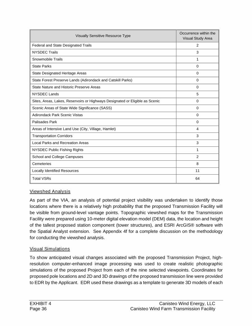
EXHIBIT 4 Canisteo Wind Energy, LLC Page 36 Canisteo Wind Farm Transmission Facility
Visually Sensitive Resource Type Occurrence within the
Visual Study Area
Federal and State Designated Trails 2
NYSDEC Trails 3
Snowmobile Trails 1
State Parks 0
State Designated Heritage Areas 0
State Forest Preserve Lands (Adirondack and Catskill Parks) 0
State Nature and Historic Preserve Areas 0
NYSDEC Lands 5
Sites, Areas, Lakes, Reservoirs or Highways Designated or Eligible as Scenic 0
Scenic Areas of State Wide Significance (SASS) 0
Adirondack Park Scenic Vistas 0
Palisades Park 0
Areas of Intensive Land Use (City, Village, Hamlet) 4
Transportation Corridors 3
Local Parks and Recreation Areas 3
NYSDEC Public Fishing Rights 1
School and College Campuses 2
Cemeteries 8
Locally Identified Resources 11
Total VSRs 64
Viewshed Analysis
As part of the VIA, an analysis of potential project visibility was undertaken to identify those
locations where there is a relatively high probability that the proposed Transmission Facility will
be visible from ground-level vantage points. Topographic viewshed maps for the Transmission
Facility were prepared using 10-meter digital elevation model (DEM) data, the location and height
of the tallest proposed station component (tower structures), and ESRI ArcGIS® software with
the Spatial Analyst extension. See Appendix 4f for a complete discussion on the methodology
for conducting the viewshed analysis.
Visual Simulations
To show anticipated visual changes associated with the proposed Transmission Project, high-
resolution computer-enhanced image processing was used to create realistic photographic
simulations of the proposed Project from each of the nine selected viewpoints. Coordinates for
proposed pole locations and 2D and 3D drawings of the proposed transmission line were provided
to EDR by the Applicant. EDR used these drawings as a template to generate 3D models of each
EXHIBIT 4 Canisteo Wind Energy, LLC Page 37 Canisteo Wind Farm Transmission Facility
structure type, insulators, conductors, and static wire. See Appendix 4f for a complete discussion
on the methodology for preparing the visual simulations.
Environmental Effects and Mitigation
As part of the VIA, an analysis of potential project visibility was undertaken to identify those
locations where there is a relatively high probability that the proposed transmission line will be
visible. This analysis includes identifying potentially visible areas based on viewshed mapping,
line-of-sight cross section analysis, and field verification.
Generally speaking, topography provides little screening in areas within 0.5 to 1 mile of the
proposed centerline and increasingly limits views as distance from the centerline increases.
Portions of the visual study area where there is no possibility of seeing the proposed transmission
structures include most stream valleys that lie in the outer portions of the visual study area, more
than 0.5 mile from the transmission line (e.g. portions of Crosby Creek, Cunningham Creek, Purdy
Creek, Stephens Creek, Fall Creek, Bennett Creek, and Milwaukee Creek). NYS Route 417 is
fully screened from the Transmission Facility views by intervening topography, as is a long section
of NYS Route 248. Factoring vegetation into the viewshed analysis, in combination with
topography, significantly reduces potential visibility throughout the visual study area. The
combination of these features will serve to block views of the Transmission Facility from
approximately 86% of the 3-mile radius study (i.e., approximately 14% of the visual study area is
indicated as having potential visibility).
Beyond evaluating potential Project visibility, the VIA also examined the visual impact of the
proposed Transmission Facility on the LSZs, identified VSRs, and viewer groups within the visual
study area. This assessment involved creating computer models of the proposed transmission
line structures, selecting representative viewpoints, and preparing computer-assisted visual
simulations of the proposed Transmission Facility. See Appendix 4f and Appendix 4f-1 for a
complete discussion on the existing and proposed views along with the visual simulations.
Cultural Resources
CWE contracted with Panamerican Consultants, Inc. (PCI) to conduct a Phase 1A Cultural
Resources Investigation, Phase 1B Archaeological Investigation, and Phase 1B Architectural
Resource Survey for CWE and the associated Transmission Facility (PCI, 2017; PCI, 2018b; PCI,
2018a). This investigation examines archaeological and architectural/historic resources within the
area of potential effect (APE) using data reviews and field surveying techniques. Results of the
Phase 1A Cultural Resources Investigation are discussed below, and the Phase 1B
Archaeological Investigation is included in Appendix 4b.
Background
The area surrounding CWE and the Transmission Facility has primarily been affected by
agricultural land use and forest clearing in recent centuries. Prior to that, Paleo-Indians occupied
various parts of New York State. These nomadic people eventually began settling into hunting
camps and building communities in the late Woodland Period. When European settlers came to
EXHIBIT 4 Canisteo Wind Energy, LLC Page 38 Canisteo Wind Farm Transmission Facility
New York, many Native Americans engaged in fur trade. Haudenosaunee people engaged on
either side of the Revolutionary War and eventually lost their claim to the land at the Treaty of Big
Tree. The land that would eventually become Steuben County was home to several industries,
including agriculture, dairying, lumbering, oil drilling, and salt mining. Today, the primary industry
is agriculture, with many communities remaining small and rural in character. In their Cultural
Resources investigation, PCI identified several farmsteads, school, cemeteries, and churches
within the study area for the CWE Transmission Facility.
Archaeological Resources Survey
CWE contracted with PCI to conduct a Phase I A Cultural Resources Investigation and a Phase
1B Archaeological Investigation to evaluate archaeological sensitive areas in proximity to the
Transmission Facility. The Phase 1A report examined previously identified archaeological sites
and historic maps to determine survey locations for the Phase 1B Archaeological Investigation
(PCI, 2018). Based on the Phase 1A findings, field investigations for the Phase 1B Archaeological
Investigation focused on the 4.4-mile stretch of Transmission Facility that runs closest to the
Canisteo River.
Field investigations for the Phase 1B Archaeological Investigation were conducted in July and
August of 2018 within a 100-foot ROW along a 4.4-mile stretch of the proposed Transmission
Facility (hereafter referred to as the area of potential effect or APE). Field surveys included shovel
pit tests and systematic surface inspections. Laboratory analysis included the grouping and
categorization of lithic artifacts and debitage by morphology, material, and function. The purpose
of such analysis is to distinguish tool manufacturer from tool maintenance activities and enable
inferences to be made about prehistoric site use and settlement patterns.
A total of 2,563 shovel test pits and 15 acres of surface surveys were performed within the APE.
Field surveys identified four broadly defined, precontact or historic Native American,
archaeological sites, and scattered artifacts within the APE. All of the site were in proximity to the
Canisteo River.
Additional artifacts were identified outside of the four precontact sites; however, these were not
considered to represent archaeological sites due to their isolated locations or surrounding
disturbances. Additional information regarding archaeological findings is provided in Appendix 4b.
Architectural/Historic Property Structures Survey
CWE contracted with PCI to conduct an architectural/historic resources survey for the
Transmission Facility. The purpose of the study was to identify and assess all buildings/structures
of at least 50 years of age or older to determine the potential of New York State/National Register
of Historic Places (S/NRHP) eligibility using National Register Criteria for Evaluation. The survey
also examines resources previously inventoried for listing or eligibility with S/NRHP.
Data sources for the survey include archival, documentary, and historical map research; New
York State Historic Preservation Office (NYSHPO) Cultural Resources Information System (CRIS)
database; and field reconnaissance of historical structures (i.e. minimum of 50 years old). Field
EXHIBIT 4 Canisteo Wind Energy, LLC Page 39 Canisteo Wind Farm Transmission Facility
reconnaissance was conducted in August 2018 and was broken out into previously inventoried
resources and newly inventoried resources. For previously inventoried resources, survey
methods included the collection of GIS data, building information, and photographs. For newly
inventoried resources, data collection included location, architectural style, physical
characteristics, building material, integrity of the resource and its setting, current/historic use, and
other defining features.
The architectural survey was conducted in the following municipalities for which the Transmission
Facility traverses: Towns of Canisteo, Hornellsville, and Jasper, City of Hornell, and the Village of
Canisteo. A summary of the architectural resources survey is outlined below by municipality.
Additional information is provided in Appendix 4b.
Town of Canisteo
A total of 13 historic resources were identified in the Town of Canisteo by PCI. Two of the
resources were previously inventoried and evaluated as National Register- Eligible (S/NRE); the
Laurel Glen Stock Farm and the Catatunk Road Bridge. The following unevaluated resources,
three newly inventoried and one previously inventoried, were recommended for S/NRE status:
South Canisteo United Methodist Church & Rectory
Stephens House/Willow Bend Farm (USN 10107.000039)
Stephens Cemetery
Bennetts Cemetery
Additional unevaluated resources identified in the Town of Canisteo include five newly inventoried
cemeteries and two previously inventoried resources. These resources were not recommended
for New York State/National Register-Eligible (S/NRE) or New York State/National Register-Listed
(S/NRL) status by PCI.
Town of Hornellsville
Three historic resources were identified in the Town of Hornellsville, including two previously
inventoried and one newly inventoried resource. One previously inventoried, unevaluated
resource (USN 10117.000026) was recommended by PCI to not be eligible for S/NRE or S/NRL
status. The other previously inventoried, unevaluated resource is the McBurney House (USN
10117.000001/000002), located along McBurney Road, which is recorded as the oldest house in
Steuben County. Local historians have also identified the house as being associated with the
Underground Railroad. PCI recommends further evaluation for the McBurney House in its NRHP
status.
Another house located along McBurney Road was identified and newly inventoried by this survey.
The Federal-styled residence was largely obscured from the road by trees and vegetation, so PCI
recommended the site hold a status of unevaluated.
Town of Jasper
A total of 19 resources were identified in the Town of Jasper, by the architectural resources
survey. One previously inventoried resource, a Queen Anne residence located off of Highup
EXHIBIT 4 Canisteo Wind Energy, LLC Page 40 Canisteo Wind Farm Transmission Facility
Road, has the status of S/NRE. Seven additional, previously inventoried resources were identified
in the Town of Jasper including five cemeteries), “The Wigwams,” and an unidentified building.
The five cemeteries were recommended by PCI to be evaluated as not eligible for NRHP inclusion
due to lacking criteria.
Additionally, 11 newly inventoried resources were identified in the Town of Jasper by PCI. Of
these resources, seven were recommended to be evaluated as S/NRE. The seven resources
include:
Jasper Grange Hall
Residence, Greek Revival
Five Corners Cemetery
Schenck Cemetery
Hampshire Cemetery
Jasper Village Cemetery
Talbot Cemetery
The remaining four newly inventoried resources were identified as cemeteries and were
recommended to be categorized as unevaluated.
City of Hornell
A total of 194 architectural/historic structures were identified in the City of Hornell based on historic
database reviews and field surveys. Of the 194 resources, 185 were previously inventoried and
unevaluated. PCI recommends that the 185 resources be not eligible for listing under NRHP.
These resources represent buildings that have been altered, changed, stripped, or removed,
thereby negating individual and/or collective characteristics that are required for the NRHP.
One S/NRL resource and one S/NRE resource were identified in the City of Hornell, the Lincoln
School, and the Erie Railroad Station, respectively. Additionally, seven newly inventoried
resources were recommended by PCI to be evaluated as S/NRE. Those resources include:
Rehobeth Deliverance Ministry (USN 10141.000898)
Craftsman residence (USN 10141.000110)
Residence, Greek Revival (USN 10141.000158)
Late 19th-century residence with gable details (USN 10141.000756)
Residence, late 19th century
Residence, Queen Anne
Residence, Queen Anne, brick
Village of Canisteo
Within the Village of Canisteo, 39 architectural/historic resources were identified by the survey.
Three of these resources were previously inventoried and evaluated as S/NRL or S/NRE. The
Canisteo Living Sign located along NY 248 is currently listed on the NRHP, while the Canisteo-
Greenwood High School and a commercial building at 1 Main Street are evaluated as S/NRE.
EXHIBIT 4 Canisteo Wind Energy, LLC Page 41 Canisteo Wind Farm Transmission Facility
Of the 39 identified resources, 24 newly inventoried resources were recommended for S/NRE
status. Thirteen of these resources are recommended for individual S/NRE status, but also
contribute to the establishment of two historic districts; the East Main Street Historic District and
the Prospect Avenue Historic District. The remaining 11 newly inventoried resources
recommended for S/NRE status are located outside of the historic districts.
Additionally, 12 previously inventoried resources were identified by the survey and recommended
to be evaluated as not eligible for NRHP status due to lack required criteria. For further
information, reference Appendix 4b.
Impacts and Mitigation
Archaeological Resources
Based on the results of archaeological field surveys, Precontact Sites 1 through 4 are potentially
eligible for listing in the NRHP. However, CWE anticipates avoiding precontact sites to the
maximum extent practicable by making the construction APE smaller than the 100-foot APE used
in the Phase 1A and Phase 1B surveys, by using steel monopole tower structures, which would
reduce the APE to 80-feet. Timber matting may be used during construction to mitigate potential
site damage. Where archaeological sites are unavoidable, CWE will perform Phase 2B surveys
in coordination with SHPO, USACE, and tribal authorities.
CWE will not initiate additional investigation for the isolated artifacts. According to PCI, the
isolated artifacts are stray deposits and are not indicative of the presence of archaeological sites
with potential for listing in the NRHP.
Historic Property Visual Resources
The most significant impacts will occur in rural agricultural landscapes, and other open/clear views
of the proposed Transmission Facility. Some screening will be afforded by natural landscape,
trees, shrubs, and other vegetation.
CWE will mitigate adverse visual effects to S/NRE and S/NRL properties in accordance with
Section 106 of the National Historic Preservation Act and Article 8 of the New York State
Environmental Conservation Law. CWE proposes the following criteria for “historical mitigation”:
Be consistent with the guidance of NYSHPO
Have historical significance
Serve a public historic purpose
Be a good investment
Be appropriate to the state of preservation of local historical resources
Noise Impacts
Potential impacts as a result of noise generally occur within two categories: short-term impact
from construction and long-term impact from operation. Construction-related noise could result
from construction of the substations and installation of the Transmission Facility. Long-term

EXHIBIT 4 Canisteo Wind Energy, LLC Page 42 Canisteo Wind Farm Transmission Facility
related noise impacts would potentially result from the operation of the Transmission Facility,
primarily from the collection or POI substation. Hankard Environmental Inc. (HEI) has evaluated
predicted noise levels during construction and operation of the Transmission Facility, as well as
applicable standards and potential mitigation measures in the Pre-Construction Noise Analysis
(Appendix 4g). These impacts are summarized below by project component.
Construction
In general, the sound levels from construction activities will be dominated by the loudest piece of
equipment operating at the time. Therefore, at any given point along the work area, the loudest
piece of equipment will be the most representative of the expected sound levels in that area.
Construction equipment is generally not operated continuously at maximum load, with significant
variation in power and usage. Actual received sound levels fluctuate depending on the
construction activity, equipment type, and separation distances between source and receiver.
Other factors, such as terrain and obstacles such as buildings, will act to further limit the impact
of construction noise levels.
Construction activity noise levels will vary depending on the phase of construction in progress at
any one time. These construction phases include site preparation, installation, and site finishing.
HEI evaluated noise under two different conditions including the one-hour average noise level,
and a maximum noise level. Then taking those conditions, HEI analyze noise levels as distance
from the construction area increases. Distances used for the purpose of the analysis were 180
feet (closest residence to construction), 350 feet, 1,000 feet, and 0.5 mile.
Table 4-11. Predicted Construction Noise Levels
Construction Phase Noise Level at 180
feet (dBA)
Noise level at 350
feet (dBA)
Noise level at 1,000
feet (dBA)
Noise Level at 0.5
mile (dBA)
Clearing 84 76 67 59
Foundation 81 73 64 56
Setting 82 74 65 57
Stringing 81 73 64 56
Underground 80 72 63 55
Predicted sound levels resulting from construction ranges from 55 dBA to 84 dBA, depending on
location from the site and phase of construction. However, much of the time, levels will range from
about 55 dBA to 75 dBA when construction is occurring at further distances. Construction will be
temporary, lasting approximately for approximately 16 weeks, and will be conducted during
daytime hours. Therefore, construction of the Transmission Facility is not anticipated to create
any significant noise impacts.
NYSDEC recommended noise mitigation for any given project and the applicability to the
Transmission Facility are discussed below:
EXHIBIT 4 Canisteo Wind Energy, LLC Page 43 Canisteo Wind Farm Transmission Facility
Replacing back-up beepers on machinery with strobe lights to eliminate annoying impulse
beeping. This mitigation measure is appropriate for nighttime work or on projects where
work is concentrated in one area for an extended period of time. It is not necessary for
the Transmission Facility given that no nighttime work is proposed and construction near
any one residence will not last more than a few days to a week at a time.
Using appropriate mufflers to reduce the frequency of sound on machinery that pulses,
such as diesel engines and compressed air machinery. Construction equipment for the
Transmission Facility will have functional, well-maintained mufflers on all engine-
equipped machinery.
Reduce noise duration by limiting the number of days of operation, hours of operation,
and specifying the time of day and limiting noisier operations to normal work day hours.
All construction activities for the Transmission Facility will take place during daytime hours
(7:00 AM to 7:00 PM) and no construction will be allowed on Sundays.
The Applicant will also communicate with the public and respond to complaints as indicated in the
Complaint Resolution Plan, outlined in the Article 10 Application. Further information on
construction impacts and mitigations measures are provided in Appendix 4g.
Operation
After construction, the only noise from the Transmission Facility operation is that of the relatively
faint “corona effect” which can occur during damp weather. Under these conditions, power lines
sometimes emit a crackling sound due to the small amount of electricity ionizing the moist air near
the wires. HEI analyzed the noise levels from corona discharge using methods and equations
developed by the Bonneville Power Administrations (BPA). Noise levels were predicted 40 feet
from either side of the Transmission Facility, at the single closest residence (180 feet), and at a
distance of 250 feet that is representative of the next few closest residences. At all locations and
under all conditions, corona noise is expected to be inaudible and is not expected to increase
ambient noise levels at any of the residences located adjacent or near the Transmission Facility.
Further details are provided in the Pre-Construction Noise Analysis (Appendix 4g).
Electric and Magnetic Field Strengths
The proposed transmission line and the respective right-of-wayROW cross-sections were
analyzed to determine compliance with the PSC’s requirements referenced in the Statement of
Interim Policy and Magnetic Fields, dated September 11,1990 and in Opinion No. 78-13. The PSC
requires that the electric field strength measured at one meter above the ground at all locations
along the edge of the ROW shall be less than 1.6 kV/m. The PSC also requires that the electric
field strength at one meter above ground within the ROW shall be less than 7.0 kV/m over public
roads, 11.0 kV/m over private roads, and 11.8 kV/m over all other areas. The PSC requires that
magnetic field strength at one meter above ground at the edge of the ROW does not exceed 200
milligauss (mG).
EXHIBIT 4 Canisteo Wind Energy, LLC Page 44 Canisteo Wind Farm Transmission Facility
Electric and magnetic field (EMF) values were calculated using PLS-CADD software, based on
preliminary structure drawings prepared by ECI (see Appendix 4j). Calculations were made using
typical values for two structure types: steel monopole and wooden H-frame. The line currents
used for the EMF calculations were based on the maximum load for this line of 290 MW for 100%
loading and 92.8 MW for a capacity factor of 32%. The resulting line currents of 1,454 Amps and
465 Amps, respectively, assume a power factor of 100%.
The maximum electric field density observed at 100% loading capacity along the ROW was 1.94
kV/m between towers 33 and 34. This is well below the New York State guideline of 11.8 kV/m.
The maximum magnetic field density observed at 100% loading capacity along the edge of the
ROW was 106.07 mG; this value is also well below the State guideline of 200 mG. For more
information regarding the EMF Study, please reference Appendix 4j.
EXHIBIT 4 Canisteo Wind Energy, LLC Page 45 Canisteo Wind Farm Transmission Facility
References
Audubon. 2018. Important Bird Areas: New York. Available at: https://www.audubon.org/important-bird-areas/state/new-york (Accessed August 2018).
New York Natural Heritage Program (NYNHP). 2018. Northern Harrier Information Guide. Last updated on March 12, 2018. Available at: http://acris.nynhp.org/report.php?id=6812 (Accessed August 2018).
Bonneville Power Administration (BPA). 1977. Empirical Expressions for Calculating High Voltage Transmission Corona Phenomena, Chartier.
New York State Department of Environmental Conservation (NYSDEC). 2015. State Wildlife Action Plan (SWAP): An Approach to Conserve At-Risk Fish and Wildlife Species. Available at: https://www.dec.ny.gov/animals/7179.html (Accessed August 2018).
NYSDEC. 2018a. Bird Conservation Area Program and Sites. Available at: https://www.dec.ny.gov/animals/30935.html (Accessed August 2018).
New York State Museum/New York State Geological Survey. 1999a. Statewide Bedrock Geology [GIS data]. Release date: July 14, 1999. New York State Museum Technology Center. Available at: www.nysm.nysed. gov/gis/#state (Downloaded October 9, 2012).
New York State Museum/New York State Geological Survey. 1999b. Surficial Geology [GIS data]. Release date:
February 22, 1999. New York State Museum Technology Center. Available at: www.nysm.nysed.gov/ gis/#state (downloaded November 14, 2005).
PCI. 2017. Phase 1A Cultural Resources Investigation for the Proposed Canisteo Wind Energy Center, Towns of Cameron, Canisteo, Greenwood, Jasper, Troupsburg, and West Union, Steuben County, New York. Prepared for Invenergy Wind LLC.
Panamerican Consultants, Inc (PCI). 2018a. Five-Mile Visual APE Architectural Resource Survey for the Proposed Canisteo Wind Energy Center, Towns of Cameron, Canisteo, Greenwood, Jasper, Troupsburg, and West Union, Steuben County, New York. Prepared for Invenergy Wind LLC.
PCI. 2018b. Phase 1B Archaeological Investigation of the Canisteo Wind Energy Center Project, Towns of Cameron, Canisteo, Greenwood, Jasper, Troupsburg, and West Union, Steuben County, New York. Prepared for Invenergy Wind LLC.
Steuben County Industrial Development Agency (IDA). 2014. Economic Development Plan 2014 – 2015. Available at: https://www.steubencony.org/Files/Documents/steuben-county-economic-development-plan-2014-15-ffv.pdf (Accessed August 2018).
Steuben County IDA, Cornell Cooperative Extension of Steuben County. 2015. Agricultural & Farmland Protection Plan. Prepared for the Steuben County Planning Department with funding and support the from NYS Department of Agriculture and Markets.
EXHIBIT 4 Canisteo Wind Energy, LLC Page 46 Canisteo Wind Farm Transmission Facility
Town of Hornellsville. 2013. Town of Hornellsville Zoning Ordinance. March 1975, Amended December 1992, Amended May 2013.
USDA Natural Resources Conservation Service (NRCS). 1978. Soil Survey of Steuben County, New York. In cooperation with Cornell University Agricultural Experiment Station.
United States Fish and Wildlife Service (USFWS). 2015. Northern Long-Eared Bat. Available at: https://www.fws.gov/midwest/endangered/mammals/nleb/pdf/NLEBFactSheet01April2015.pdf (Accessed August 2018).