canoe trek guide - chief pontiac programschiefpontiacprograms.org/pdf/cptmapcw.pdf · the local...
TRANSCRIPT

RDS.CW.110609
Canoe Trek Guide Kensington Start Edition
Chief Pontiac Trail
Credential Hikes

RDS.CW.110609
WP# Dist. Feet
Accum. Miles
Dist. Meters
Accum. Meters
1 0 0.0 0 0
2 410 0.1 125 125
3 492 0.2 150 275
4 804 0.3 245 520
4A 919 0.5 280 800
5 1,640 0.8 500 1,300
6 1,148 1.0 350 1,650
7 984 1.2 300 1,950
8 230 1.3 70 2,020
9 6,070 2.4 1,850 3,870
10 3,117 3.0 950 4,820
11 1,903 3.4 580 5,400
12 1,148 3.6 350 5,750
13 492 3.7 150 5,900
14 640 3.8 195 6,095
15 230 3.8 70 6,165
16 82 3.8 25 6,190
17 689 4.0 210 6,400
18 1,804 4.3 550 6,950
19 591 4.4 180 7,130
19A 1,345 4.7 410 7,540
20 1,378 4.9 420 7,960
21 755 5.1 230 8,190
22 197 5.1 60 8,250
23 902 5.3 275 8,525
24 427 5.4 130 8,655
25 1,099 5.6 335 8,990
26 459 5.7 140 9,130
27 689 5.8 210 9,340
28 984 6.0 300 9,640
29 492 6.1 150 9,790
30 1,886 6.4 575 10,365
31 1,033 6.6 315 10,680
32 2,543 7.1 775 11,455
33 656 7.2 200 11,655
34 410 7.3 125 11,780
35 2,051 7.7 625 12,405
36 1,640 8.0 500 12,905
37 902 8.2 275 13,180
38 984 8.4 300 13,480
39 6,102 9.5 1,860 15,340
40 5,249 10.5 1,600 16,940
41 2,822 11.1 860 17,800
42 2,953 11.6 900 18,700
43 1,903 12.0 580 19,280
44 6,726 13.3 2,050 21,330
45 4,511 14.1 1,375 22,705
46 7,710 15.6 2,350 25,055
Whenever you are on the river,
you must wear shoes and a PFD at all times!!!
Hiking is a personal choice
and requires personal responsibility Hiking, backpacking, canoeing, and other associated
CPT trail activities are dangerous and can result in injury
and/or death. These activities expose you to risks. Risks
are mitigated, but NOT eliminated by training or skill.
The BSA/GLC/CPP assumes ABSOLUTELY NO
responsibility, including but not limited to injury or loss
due to the use of information, or participating in
activities found within this guide.
Disclaimer and Restriction of Liability
The BSA/GLC/CPP provides this guide as a free service.
While we’re satisfied that this guide is dependable in the
majority of cases at the time of publication, this guide
may not reflect current ground conditions. Please use
this guide as such and not as definitive information. All
such information is provided "as is" without warranty of
any kind. We make no claims, promises or guarantees
about the overall accuracy, completeness, or adequacy of
the contents of this guide and expressly any and all
liability for bodily injury and property damage
associated with the use of this guide. In no event shall
the BSA/GLC/CPP be liable for any special, direct,
indirect, consequential or incidental damages or injury.
No responsibility is assumed for damages or other
liabilities due to the accuracy, availability, use or misuse
of the information herein provided.
Sharing the trail with horses
It is very common to come upon horses and riders along
this entire trek. The local trail rider’s association
recommends that when you encounter them to stand a
ways off of the trail, but still visible to the horses. While
waiting for the horses to pass maintain eye contact with
the horses and speak softly to them. This will let the
horses recognize you as being a human, instead of a
predator. Once the horses have passed you may resume
your trek.
About The Maps
The trail data points were collected using a Lowrance
H2O-C handheld GPS with an attached Gilsson
amplified external antenna. Topographical trail maps
were produced using ExpertGPS by TopoGrafix. Final
images and pages were composed using Adobe
Photoshop, MS Word, and Adobe Acrobat.

CPT Canoe Trek 1st day, Group Camp to South Hill Road
(Kensington Start Edition, Canoe Map #1) NOTES
It is very common to come upon horses and riders along this entire trek. The local trail rider’s association
recommends that when you encounter them to stand a ways off of the trail, but still visible to the horses. While
waiting for the horses to pass maintain eye contact with the horses and speak softly to them. Once the horses have
passed you may resume your trek.
Several portions of this trek will lead through areas of poison ivy and thorny bushes and contact is unavoidable. It
is therefore highly recommended that you wear pants, preferably synthetic, when hiking. Wear pants, not shorts!
1. SE – Your days trek begins on the bridge over the Huron River in the Kensington Group Camp. Go southeast
from the bridge (125m) to the first latrine.
2. S – Proceed up the steep embankment to the upper campsite and head south (150m) to the second latrine.
3. S – From the gate proceed south to a four-way intersection of trails (245m).
4. SE – From this intersection continue going southeast. After taking either path at the split, proceed to the paved
bike trail (280m). Staying on the dirt path, continue southeast across the paved bike trail and into the woods.
Proceed on the path to the CPT arrowhead sign at Dawson Road (500m).
5. S – Head south across Dawson Road and proceed to the paved bike path. Hiking on the grass on the east side of
the pavement, head southeast to a wooden CPT trail post (350m).
6. SE – Turn southeast and head up the hill. At the top of the hill you will find a path. Continue southeast to a CPT
arrowhead sign post near the intersection of Milford Road and the Metropark entry road (300m).
7. S/E/N – For safety reasons, cross Milford Road in the following manner: Head south across Huron River Pkwy
towards the Dairy Queen, east across Milford Road, then north back across Huron River Pkwy (70m). This is
because the traffic light may start the northbound traffic before the southbound side without warning.
8. NE – Now head northeast (40m) to the two trailheads. Proceed onto the “Hike-Bike Trail", NOT the horse trail,
and continue northeast (1.8km). The hiking trail you use is well worn, runs parallel to the equestrian trails to
your south, and takes an eastward track to South Hill Road.
Notes: Between Milford and South Hill Roads this trail curves and is bisected by several grassy trails from the
local homes. Hike only on the hike-bike trail. A CPT arrowhead sign is located on the west side of the road.

CPT Canoe Trek 1st day, South Hill Road to Childs Lake Road
(Kensington Start Edition, Map #2) NOTES
The trail is intersected with many equestrian trails and meeting horses and riders should be expected.
This portion of Proud Lake State Recreation Area is open to hunting during the season, so please be cautious.
Note: Between South Hill and Old Plank Road hike only on the hike-bike trail. If ever signs indicate you are on
an equestrian trail, backtrack and return to the hike-bike trail. East of Old Plank Road the trails are combined.
9. E – After crossing South Hill Road, continue on the Hike-Bike Trail and proceed east through the woods (440m).
You will exit the woods into a bushy meadow, continue east. After a while (400m) you will re-enter the woods.
Head southeast through the woods, then south a short way to a four-way intersection (110m). If you should come
out to Old Plank Road, turn around and proceed back to the intersection (85m).
10. S – Continue south from the four-way intersection and then east out to Old Plank Road (580m).
11. E – Cross Old Plank Road, exiting the Metropark and entering Proud Lake State Recreation Area. The trail rises
uphill from the road and goes into a grove of hickory trees. Head east (350m) to the next intersection.
12. N – From this intersection you turn north and hike downhill. Midway down a steep descent is the next
intersection (150m).
13. E – Turn east and then head northeast and downhill (195m) to the next intersection.
14. N – Turn north and then proceed northeast (70m) to the next intersection.
15. N – Take the trail heading north a very short distance to the next intersection (25m).
16. E – Turn east and then head northeast (210m), through a thick green glen and out to Childs Lake Road.

CPT Canoe Trek 1st day, Childs Lake Road to Pines Lower Campsite
(Kensington Start Edition, Canoe Map #3)
17. NE – After crossing Childs Lake Road the trail goes northeast, joining with more equestrian trails. Head northeast
until you come to an intersection with a trail heading east (550m).
18. E – From here turn and head east. Eventually you will come out to a set of railroad tracks (180m). These are active
tracks and you are cautioned to be careful and follow all safety rules. Follow the pavement over the tracks.
19. ?? – Note: In the spring the trail leading to The Russell Bridge may be flooded.
19. E – In dryer conditions, follow the trail east over The Russell Bridge to another CPT arrowhead sign (410m).
19A. N – Turn north, taking either path when the trail splits, hike to the equestrian trail (420m).
19. N – If the trail is flooded, turn follow the route north to where the path splits (200m).
19B. NNE – At the split, veer to the north-northeast and continue on this trail (350m) until you enter a large
meadow. Turn southeast and follow its perimeter around to the picnic area. Here you will find a water pump,
latrine and tables. Continue northeast and across the bridge over Norton Creek (400m). Immediately past the
bridge turn southeast onto the equestrian trail. Proceed down this path (150m) until you intersect with another trail
that runs parallel to Garden Road.
20. SE – From this junction you head southeast and then east (230m) until you come to a point where you can clearly
see downhill to Garden Road and a trail leading steeply down to the road.
21. NE – Follow the path downhill towards Garden Road and to the two wooden posts (60m).
22. SE – At the wooden posts cross the road, head southeast a short distance (50m), turn north and go down the
driveway to Heavner Canoe Rental. Stop here and pay your canoe rental (225m).
NOTE: For an early morning start tomorrow, have the canoes dropped off at the boat launch today. Then paddle
them back to the campsite this afternoon before it gets dark.
23. E – Head east from the rental office down the driveway, then veer off into the woods to the “Nature Trail” (130m).
24. NE – Turn northeast at where the trail splits. Follow this trail until you enter a clearing in the woods (335m).
25. NE – Turn northeast to find the trail heading out to Wixom Road. Follow this path until you come to one of the old
CPT metal arrowhead signs (140m).
26. E – From the CPT sign head east across Wixom Road to the access road for the riverbank picnic area. Hiking along
its eastern edge continue northeast up the access road and through the parking lot (210m).
27. E – Turn onto the last path heading east along the river, which is about 20 meters before the riverbank. Proceed
east (300m) until you reach the pavilion in the Lower Pines Campsite.

CPT Canoe Trek 2nd
day, Pines Campsites to Lower Pines Dock
(Kensington Start Edition, Canoe Map #4) NOTES
Whenever you are on the river, you must wear shoes and a PFD at all times!!!
After paddling under the power lines, you must paddle along the northern shoreline to find the narrow inlet!
The river between the dam and Wixom Road is a designated “Quality Fishing Area”. Please be courteous.
Before you begin paddling you must read all of the notes on Canoe Map #7. Read and comply with the warnings
about the Hubble Pond Dam and where you are required to land your canoe for pick-up by the canoe livery.
28. S – Head south across the campsite and then uphill on the access road to the top of the hill (150m).
29. SE – Turn onto the downhill path heading southeast. Continue southeast to the four-way intersection (575m).
ATTENTION: There is a pump in the Upper Pines Campsite (West 100m from WP #29). The next water source is
located in Central Park (WP #44). If you have less than two liters of water, fill up now!
30. N – Turn north and proceed in a northeast direction to the next intersection (315m).
31. N – Turn north, then curve southeast following this path to the dam (775m). Once at the dam it is a good time for
a break to adjust packs and use the latrines.
Note: At this point you are less than an hour’s hike from the boat launch. Just before you resume hiking, you
should call Heavner Canoe Rental to verify the canoes have been delivered to the boat launch; 248-685-2379.
32. E – After crossing over the bridge, continue east to the second marked intersection (200m).
33. NE – Turn northeast and head to the next intersection (125m).
34. E – Take the trail heading east (625m).
35. E – Continue east to the next intersection just passing under two sets of power lines (500m).
36. SW – Just past the power lines turn onto the trail heading southwest. This path runs parallel to the lines (275m).
37. SE – The trail will turn and head southeast (200m) to the boat launch parking lot. From here proceed southeast
(100m) down to the boat ramp.
38. At the boat ramp is where the canoes have been dropped off for you. At this point you will load your canoe and
begin your trip downriver. Once on the water, proceed southwest from the boat launch into Proud Lake. After
passing under the power lines, paddle along the northern shoreline to find the narrow inlet. Turn into the channel
leading to Moss Lake and proceed down river to the dam. When nearing the dam, paddle towards the right bank.
39. Portage on the right side of the dam. After the dam the river meanders past the Pines Campsites towards Milford.

CPT Canoe trek 2nd
day, Lower Pines Dock to Burns Road
(Kensington Start Edition, Canoe Map #5) NOTES
If you have any problems or need assistance you can turn into the channel and it will take you directly to the
canoe livery where you started hiking. If you do not need help, then do not turn into the channel.
40. Continue on down the river past the picnic area towards Wixom Road. After you cross under the bridge on
Wixom Road, you will soon see a sign for the channel to Heavners Canoe Rental.
41. Continue paddling down the river and pass under Burns Road.

CPT Canoe Trek 2nd
day, Burns Road to Central Park
(Kensington Start Edition, Canoe Map #6) NOTES
There are water and portable toilets at Central Park.
Central Park in Milford is a popular place to stop for lunch.
Beware of the waterfowl. While it is tempting to feed them, Milford has ordinances prohibiting it. Read the signs
posted and act accordingly.
In this stretch of river you will pass under several bridges and have the opportunity to see plenty of wildlife.
Turtles sunning on rocks, ducks, geese, and swans, and snakes sunning themselves on branches over the water are
all common sites. Springtime groups will often see waterfowl on nests just off the edge of the river. There are
plenty of red-winged blackbirds that inhabit the reeds and cattails along here.
42. From Burns Road follow the river to Monteagle Road and a large cemetery on your left.
43. From Monteagle Road continue downstream passing under the old railroad trestle and the Main Street Bridge.
Central Park is on the northern shore just past the bridge.
CPT Canoe Trek 2nd
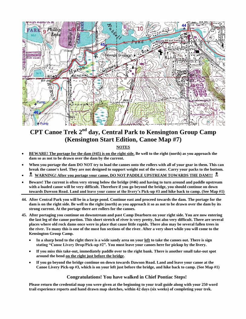
day, Central Park to Kensington Group Camp
(Kensington Start Edition, Canoe Map #7) NOTES
BEWARE! The portage for the dam (#45) is on the right side. Be well to the right (north) as you approach the
dam so as not to be drawn over the dam by the current.
When you portage the dam DO NOT try to load the canoes onto the rollers with all of your gear in them. This can
break the canoe's keel. They are not designed to support weight out of the water. Carry your packs to the bottom.
WARNING! After you portage your canoe, DO NOT PADDLE UPSTREAM TOWARDS THE DAM!!!
Beware! The current is often very strong below the bridge (#46) and having to turn around and paddle upstream
with a loaded canoe will be very difficult. Therefore if you go beyond the bridge, you should continue on down
towards Dawson Road. Land and leave your canoe at the livery’s Pick-up #3 and hike back to camp. (See Map #1)
44. After Central Park you will be in a large pond. Continue east and proceed towards the dam. The portage for the
dam is on the right side. Be well to the right (north) as you approach it so as not to be drawn over the dam by its
strong current. At the portage there are rollers for the canoes.
45. After portaging you continue on downstream and past Camp Dearborn on your right side. You are now entering
the last leg of the canoe portion. This short stretch of river is very pretty, but also very difficult. There are several
places where old rock dams once were in place that cause little rapids. There also may be several fallen trees in
the river. To many this is one of the most fun sections of the river. After a very short while you will come to the
Kensington Group Camp.
In a sharp bend to the right there is a wide sandy area on your left to take the canoes out. There is sign
stating “Canoe Livery Drop/Pick-up #2”. You must leave your canoes here for pickup by the livery.
If you miss this take-out, immediately paddle over to the right bank. There is another small take-out spot
around the bend on the right just before the bridge.
If you go beyond the bridge continue on down towards Dawson Road. Land and leave your canoe at the
Canoe Livery Pick-up #3, which is on your left just before the bridge, and hike back to camp. (See Map #1)
Congratulations! You have walked in Chief Pontiac Steps!
Please return the credential map you were given at the beginning to your trail guide along with your 250 word
trail experience reports and hand drawn map sketches, within 42 days (six weeks) of completing your trek.