cape fear river blueprint
TRANSCRIPT

Executive Summary | 1
2018 ǀ Blueprint
Lower Cape Fear River
Blueprint

Blueprint | 2
The Lower Cape Fear River Blueprint has been made possible through funding provided by
the Orton Foundation, an affiliate of the Moore Charitable Foundation.
North Carolina Coastal Federation 3609 Highway 24 Newport, NC 28570 Tel: (252) 393-8185 Fax: (252) 393-7508 nccoast.org
Blueprint | 3
Contents Executive Summary 4
Introduction 5
About the River 6
Why Protect the River: Our Community Backbone 7
Why Protect the River: Economic Engine for the Region 8
Why Protect the River: A Coastal Wonder 9
Issues of Concern 10
A Plan for the Future: The Coastal Resilience Initiative 12
Lower Cape Fear River Blueprint: Goals and Strategies 13
Goal 1. Water Quality 14
Goal 2. Living Shorelines 20
Goal 3. Oysters 24
Goal 4. Invasive Species Management 30
Implementation and Next Steps 32
Acronyms and Definitions 34

Blueprint | 4
Executive Summary Since 1982, the North Carolina Coastal Federation has worked with residents and visitors of North Carolina to protect and restore the coast, participating in many issues and projects within the Cape Fear region. The Lower Cape Fear River provides critical coastal and riverine habitat, storm and flood protection, and commercial and recreational fishery resources. It is also a popular recreational destination, an economic driver for the southeastern region of North Carolina, and embodies a rich historic and cultural heritage. The river also serves as an important source of drinking water for many coastal communities, including the City of Wilmington.
Today, the lower river needs improved environmental safeguards, and a clear vision for compatible and sustainable economic development. Further, effective leadership is needed to address existing pollution and habitat loss and prevent projects that threaten the health of the community and the river. The Lower Cape Fear River is continually affected by both local and upstream actions. The continued degradation of these essential functions threatens the well-being of all who live, work or visit southeastern North Carolina.
The North Carolina Coastal Federation works to address these issues by actively engaging with local governments, state and federation agencies, and other entities. Our Board of Directors recognize these needs and have adopted the following goals as part of a three-year, organization-wide initiative:
• Coastal water quality that supports fishing, swimming and a vibrant coastal economy • Natural and productive estuarine shorelines • Oysters that thrive and support vibrant fisheries and habitat, good water quality and a strong
coastal economy. • Effective coastal management that protects and restores the North Carolina Coast. • A coast that is free of marine debris.
The Lower Cape Fear River Blueprint (The Blueprint) is a collaborative effort to focus on the river’s estuarine and riverine natural resources. The Blueprint examines the impacts of short-sighted and unsustainable developmental practices and water quality issues of the coastal, lower Cape Fear River and explores sustainable solutions to address these and other issues threatening our valuable resource. The Blueprint focuses on specific elements related to the federation’s work, including:
• Create a planning document with a long-term vision for protecting and restoring the lower, coastal Cape Fear River;
• Conduct campaigns for enhanced environmental safeguards by developing watershed restoration plans;
• Protect water quality and reduce industrial contamination and polluted stormwater runoff; • Use living shorelines to combat erosion and to provide and restore critical estuarine habitat,
including island bird rookeries; • Restore oysters and other shellfish habitats and develop a Shellfish Enterprise Zone within
approved waters; • Develop an invasive Phragmites australis management plan.
The effort to improve the Lower Cape Fear River by creating a blueprint of achievable actions is supported by the Orton Foundation, a North Carolina-based affiliate of the Moore Charitable Foundation. The Blueprint is the result of collaborative interest from academia, private businesses, nonprofits, and local and state agencies, who recognize the value of a comprehensive plan to guide long-term decisions for the river estuary and its users. This plan serves as an adaptive tool to integrate local efforts, the North Carolina Coastal Federation efforts, and ongoing conservation work occurring upstream. This unified vision expands upon existing efforts by the Cape Fear River Partnership and Cape Fear Arch by creating a holistic platform of support and advocacy for the river and its resources.
Executive Summary

Blueprint | 5
Introduction The Lower Cape Fear River Blueprint outlines key priorities identified by the North Carolina Coastal Federation and its partners for how best to protect and restore the lower, coastal Cape Fear River estuary to create a resilient future. This long-term strategic plan focuses on lower sections of the river that function as a part of the coastal estuary. While river estuaries have no fixed boundaries, generally these sections of the river are within the Pender, Brunswick and New Hanover county region.
The lower, coastal Cape Fear River is a vital resource that is vulnerable to hazards ranging from storms to flooding to degradation from pollution to unsustainable development. A critical need exists to address and plan to manage growth and manage these risks. The Blueprint seeks to highlight the concept of selective and sustainable conservation, restoration, and planning by utilizing scientific research and collaborative planning tools to develop strategies that will be the most impactful and sustainable.
Introduction
Blueprint | 6
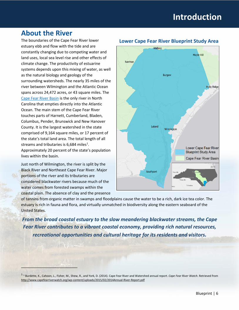
About the River The boundaries of the Cape Fear River lower estuary ebb and flow with the tide and are constantly changing due to competing water and land uses, local sea level rise and other effects of climate change. The productivity of estuarine systems depends upon this mixing of water, as well as the natural biology and geology of the surrounding watersheds. The nearly 35 miles of the river between Wilmington and the Atlantic Ocean spans across 24,472 acres, or 43 square miles. The Cape Fear River Basin is the only river in North Carolina that empties directly into the Atlantic Ocean. The main stem of the Cape Fear River touches parts of Harnett, Cumberland, Bladen, Columbus, Pender, Brunswick and New Hanover County. It is the largest watershed in the state comprised of 9,164 square miles, or 17 percent of the state’s total land area. The total length of all streams and tributaries is 6,684 miles1. Approximately 20 percent of the state’s population lives within the basin.
Just north of Wilmington, the river is split by the Black River and Northeast Cape Fear River. Major portions of the river and its tributaries are considered blackwater rivers because much of the water comes from forested swamps within the coastal plain. The absence of clay and the presence of tannins from organic matter in swamps and floodplains cause the water to be a rich, dark ice tea color. The estuary is rich in fauna and flora, and virtually unmatched in biodiversity along the eastern seaboard of the United States.
From the broad coastal estuary to the slow meandering blackwater streams, the Cape Fear River contributes to a vibrant coastal economy, providing rich natural resources,
recreational opportunities and cultural heritage for its residents and visitors.
1 1 Burdette, K., Cahoon, L., Fisher, M., Shew, R., and York, D. (2014). Cape Fear River and Watershed annual report. Cape Fear River Watch. Retrieved from http://www.capefearriverwatch.org/wp-content/uploads/2015/02/2014Annual-River-Report.pdf
Introduction
Lower Cape Fear River Blueprint Study Area

Executive Summary | 7
Why Protect the River: Our Community Backbone Many come to the lower Cape Fear River to experience its scenic wonders. In 2008, the U. S. Fish and Wildlife Service noted the Lower Cape Fear River system deserves the designation of an “aquatic resource of national importance.”2 Many federal, state and local agencies and organizations have spent millions of dollars on land conservation projects, to protect water quality and provide public recreational opportunities within the lower river basin. Beyond enjoyment of the estuary and river, it is a viable economic resource.
River-based tourism, safe drinking water, commercial and recreational fishing, and natural resource functions
are critically important to the region’s economy, attracting new residents and businesses to the region.
There are major industries and commercial and residential developments that depend on the river estuary. The Duke Energy Southport Nuclear Power Station is one of several river-based industries and major employers in the region. The International Port of Wilmington operates on the river just south of downtown Wilmington, one of two commercial ports in North Carolina. The protected coastal waters of the Cape Fear River estuary support public infrastructure, which are a vital part of transportation and employment centers in the region. There are existing recreational, commercial and industrial development and opportunities for new growth along the lower river that draw new residents to the region, which is expected to grow to over 500,000 people in the next 25 years.
The river’s health directly and vitally affects the region’s drinking water, including the costs of water supply, distribution, and treatment. The region and over 1.6 million people upstream depends upon the river for drinking water.
2 Giovannelli, M. (2008). Titan site tagged aquatic resource of National importance. WHQR. Retrieved from http://whqr.org/post/titan-site-tagged-aquatic-resource-national-importance#stream/0
Introduction

Blueprint | 8
Why Protect the River: Economic Engine for the Region The lower estuary from Wilmington south to the ocean provides critical habitat for major fisheries for finfish, shrimp and shellfish. According to the U.S. Fish and Wildlife Service, fishing, hunting, boating and other natural resource related activities generate approximately $100-$120 million annually in direct expenditures in the Cape Fear River basin3. The Lower Cape Fear River supports recreationally and commercially important marine species, such as red drum, southern flounder, blue crab, and striped mullet. The river estuary still maintains an oyster and shellfish stock, but the fishery has been seriously degraded by historic overharvesting, sedimentation and bacterial pollution. The fishery resources found in the Cape Fear River are of economic and cultural importance. Just in 2014, the N.C. Division of Marine Fisheries estimated that:
The lower Cape Fear River supported 467 jobs, $14.2 million in income, and $35.7 million in business sales.
North Carolina recreational fishing expenditures (trip related expenditures, such as, fishing and auxiliary equipment, membership dues, licenses and permits) were more than $1.5 billion in 20114. In 2010, more than 33,000 people in North Carolina were employed in the tourism and recreation industry, with their wages totaling almost $500 million5. In 2011, the total commercial fish landings in North Carolina for all species was valued at more than $71 million, $1.16 million of which was attributed to landings of striped bass alone3. Without sustainable and smart conservation actions to protect and restore habitat and improve access for migratory fish, the communities in the Cape Fear River basin stand to lose a vital economic driver for the region and state.
It is critical that our community invests in the long-term health and protection of
the Cape Fear River.
3 Burdette, K., Cahoon, L., Fisher, M., Shew, R., and York, D. (2014). Cape Fear River and Watershed annual report. Cape Fear River Watch. Retrieved from http://www.capefearriverwatch.org/wp-content/uploads/2015/02/2014Annual-River-Report.pdf 4 U.S. Department of the Interior, U.S. Fish and Wildlife Service, and U.S. Department of Commerce, U.S. Census Bureau. 2011 National Survey of Fishing, Hunting, and Wildlife-Associated Recreation. 5 Cape Fear River Basin action plan for migratory fish. (2013). Cape Fear River Partnership. Retrieved from http://www.capefearriverwatch.org/wp-content/uploads/2013/06/CapeFearActionPlan.pdf
Introduction

Blueprint | 9
Why Protect the River: A Coastal Wonder Well known for its unique and diverse ecosystems, many species of birds, mammals, fish and other wildlife can be found within the Cape Fear River estuary. Many marine organisms, especially fish important for commercial and recreational fishing, depend on these waters and adjacent wetlands at some time in their life. Due to their biologic productivity, migratory birds use wetlands as places to rear their young and a myriad of riverine and coastal wildlife depend on the sheltered waters and riparian areas of the river as spawning places.
Water draining from upstream land areas of the Cape Fear River watershed deposits sediment, nutrients and pollutants into the estuary. As the water flows through the wetlands and marshes, river and estuarine vegetation and forests, oysters, crabs and other filter feeders filter out the pollutants. The filtration process that occurs in estuaries creates cleaner, clearer water, benefitting both people and the estuarine inhabitants.
Wetlands act as natural barriers, absorb floodwaters, protect inland areas from storms, and provide that first line of defense from sea level rise and climate change.
This protects the upland habitat as well as valuable real estate. Salt marsh grasses, and other estuarine plants, help prevent erosion and they stabilize shorelines naturally, providing a beneficial alternative to bulkheads and other hardened structures along our coastal estuaries and waterways.
The estuary is part of a natural feature called the Cape Fear Arch, a unique geologic structure of the southeastern coast of North Carolina, encompassing the region south from Cape Lookout, NC to Cape Romain, SC. Geologically higher in elevation than areas near the coast to the north and south, the Cape Fear Arch represent a unique array of wet and dry habitats which are regionally and nationally significant and threatened. Many of the resident species, including the Venus Fly Trap and the Cape Fear Shiner, are endemic to the region, uniquely found nowhere else in the world6.
In 2006, multiple public and private entities united to form the Cape Fear Arch Conservation Collaborative to inform the public about the region’s geologic and natural resource features, and to protect these values and functions. Today, many natural resource agencies and conservation partners continue to work within the Cape Fear Arch Collaborative to ensure the preservation and wise use of the regions natural resources.
6 The Nature Conservancy. (2000). [Map] Biodiversity hotspots in the continental U.S. and Hawai’i. Retrieved from https://www.conservation.org/How/Pages/Hotspots.aspx
The Nature Conservancy designates the lower Cape Fear as one of the biodiversity “hotspots” along the Atlantic coast (2000).
Introduction

Blueprint | 10
Issues of Concern Historically, the Cape Fear River region has experienced major alterations and often conflicting uses of the river. Today, short-sighted and unsustainable development practices, including draining of wetlands, high-intensity clear cutting of forested areas, unregulated dumping of industrial contaminants and unmanaged stormwater runoff compound historic issues within the region.
Since the arrival of European settlers in the early 1700’s, there have been tremendous changes in the lower estuary and its associated uplands and wetlands. For much of the 18th and 19th centuries, the river’s tidal freshwater swamps were cleared, drained and diked for rice production and subsequent land development. This conversion from the historic natural habitats removed large areas of cypress and gum swamps and converted areas to fresh and saltwater marshes. Today, these relic rice fields do not receive regular exchange of fresh water, resulting in a buildup of minerals in salt flats. Characterized by pockets of very high salinity, these areas are harsh environments for our native species. Throughout the region, long-leaf pine forests dominated this region, however, current land conversions have replaced many of these borderline upland coastal habitats along the river.
Historically, the river was a major transportation corridor for industries such as lumber, tar and turpentine and was transformed into the primary transportation corridor for commerce to the interior of the state by barge and ship traffic. By the early 19th century, the river was dammed, and a series of locks constructed to facilitate commerce to and from the interior of the state north to Fayetteville and beyond. These lock and dam systems provided water supply systems for the region, but also impeded migratory fish routes. Currently, efforts are underway to address these historic modifications to the river, and the
7 North Carolina Ports. (2018). Port of Wilmington. NC Department of Transportation. Retrieved from http://ncports.com/port-facilities/port-of-wilmington/
installation of a migratory fish passageway at Lock and Dam 1, located upstream from the City of Wilmington, is a significant and important example of the types of sustainable and prudent long-term development strategies and solutions needed throughout the river.
During the 20th century and continuing today, the river channel at the mouth of the Cape Fear has been widened and deepened by dredging the Port of Wilmington. Over 26-miles of the river is dredged every five to ten years, which increases the tidal range, salinity and sedimentation of the lower estuary system. The current maintained channel depth is 42 feet (below the mean lower low water level), with recent proposals to increase the main shipping channel depth further to accommodate larger cargo ships used for international shipping trade7. At the Port of Wilmington, located adjacent to the City’s urbanized downtown area, the turning basin has been enlarged in depth and overall size to accommodate the larger vessels. The port has also undergone several major expansions in the last ten years.
Increased ship traffic and the ability of larger vessels to navigate the lower river has created a serious shoreline erosion issue, predominately along the west side of the river channel and around dredge spoil islands, which are globally important habitats for colonial waterbird nesting.
In addition to industrial and development pressures, increases in local sea level, and more frequent and intense hurricanes and rainfall events over the past century, the region has experienced increased flooding and higher average high tides, along with changes in the chemistry of the salt and freshwater wetlands and an associated conversion of the historic ecosystems.
Issues of Concern

Executive Summary | 11
Significant changes have occurred throughout the Cape Fear River Basin. The changes we have made in the past and decisions we make in the future will impact the resiliency of the estuary and its ability to bounce back from short- and long-term issues like hurricanes, flooding, sea level rise, pollution, and much more. Collectively, pressures from historic alterations, short-sighted development, unregulated industrial uses, conflicting water uses, and changes associated with climate alterations have affected drinking, surface and groundwater water supplies and quality, and ecosystem health. These changes have short and long-term implications for the region’s ability to sustain the current quality of life and economic stability.
Conflicting Uses of the River•The uses of the river may not always align with the health of the river. Activities like heavy dredging,
damming, and shipping can create a burden on the natural resources and need proactive management. The river has been continually widened and deepened by dredging. Dredging increases the tidal range, salinity and sedimentation of the estuary system. Increased ship traffic and the ability of larger vessels to navigate the lower river has created a serious shoreline erosion issue due to boat wakes, predominately along the west side of the river channel and around dredge spoil islands, which are globally important habitats for migratory bird nesting.
Historic Alterations•In addition to industrial and development pressures, increases in local sea level, and more frequent and
intense hurricanes and rainfall events over the past century, the region has experienced increased flooding and higher average high tides, along with changes in the chemistry of the salt and freshwater wetlands and an associated conversion of the historic ecosystems.
Unsustainable Development Practices•Pressures from short-sighted and unsustainable residential and commercial development practices
aggravate damage to habitat. Degradation and draining of the region’s wetlands, high-intensity clear cutting of forested areas, and dense urban development have been detrimental to the river. The Lower Cape Fear River is nestled within the coastal floodplains and storm events can result in nuisance flooding, which can effect health and safety.
Unsustainable Industrial Practices•In 2017, the contamination of the Lower Cape Fear River by emergent contaminants, such as GEN-X,
became significant issue of concern. Working with researchers from the University of North Carolina Wilmington and Duke University, the N.C. Coastal Federation and its partners presented options and clear regulatory oversight provided by the Clean Water Act to the North Carolina House of Representative Select Committee on Water Quality in September 2017.
Climate Change and Sea-Level Rise Impacts•Coupled with an increase in sea level over the past century, the region has experienced increased
flooding and higher average high tides, along with changes in the chemistry of the salt and freshwater wetlands and conversion of freshwater swamps into brackish marshes. Storms and hurricanes are significant risks to habitat, human life, and infrastructure. Storms can result in catastrophic floods, like those experienced in 2016 during Hurricane Matthew.
Issues of Concern

Blueprint | 12
A Plan for the Future: The Coastal Resilience Initiative The Lower Cape Fear River region has and will continue to deal with coastal storms, increased flooding and erosion associated with localized sea level rise, along with other natural and anthropogenic stressors. Without renewed protection and restoration, the river’s ability to withstand these pressures and remain a healthy and productive estuary is in jeopardy. To address these threats, our community must adopt a collaborative and unified approach to better manage the uses of the river and increase efforts to preserve and restore the natural resources most at risk. The Lower Cape Fear River Blueprint strategies have been developed to address these needs and are part of the North Carolina Coastal Federation’s Coastal Resilience Initiative. This initiative represents a coast-wide assessment of needs and coastal strategies that include the following priority focus areas:
•The Coastal Resilience Initiative will restore living shorelines in nearly two dozen locations along our coast in 2018. Living shorelines restore habitat, protect our coast from erosion and damage from storms, improve water quality and provide recreational opportunities such as fishing, swimming and public access. These projects demonstrate the value of living shorelines, and help create consumer demand for similar projects up and down our coastline as an alternative to bulkheads.
Living Shorelines
•The Initiative will protect and restore existing wetlands that buffer our coast from floods and pollution. We identify illegal conversions of wetlands and work to find alternatives to legal wetland loss by supporting sustainable practices like low impact development and green design.
Protect Existing Wetlands
•Over the next three years, the federation will work in partnership with the Natural Resources Conservation Service to restore more than 5,000 acres of farmland back to wetlands. Working directly with local farmers and landowners who choose to join the restoration program. These restored wetlands will offset wetland losses with a net gain of more than 3,500 acres in eastern North Carolina, and will absorb nearly seven billion gallons of runoff from large rain events!
Restoring Farmland
•The Initiative will develop new watershed restoration plans for our coastal communities each year, and help communities implement plans that have already been created. These plans identify pollutant sources and land use changes in the watershed, and prioritize actions to restore habitat and water quality. Stormwater runoff reduction measures installed through watershed plans have been shown to reduce bacteria and sediment by up to 90% and reduce polluted runoff by up to 500,000 gallons in each major storm!
Watershed Restoration Plans
•The Initiative involves encouraging our friends, neighbors and decision-makers to take action to protect our coast. The education and outreach component of the Coastal Resilience Initiative will convey information about coastal habitats and water quality, threats, resiliency actions through the initiative and what individuals can do to help. The initiative will not only implement on-the-ground projects and develop plans for future work, but will also work to change the hearts and minds of North Carolinians through public forums and workshops, as well as communications through social media, email and print materials.
Outreach and Education
Plan Overview

Blueprint | 13
Lower Cape Fear River Blueprint: Goals and Strategies Following the strategies established within the federation’s Coastal Resilience Initiative, the Lower Cape Fear River Blueprint targets specific issues and identifies implementable solutions centered on water quality and resiliency of the Lower Cape Fear River estuary ecosystem. This plan establishes four main goals and associated implementation strategies to address the environmental challenges and pressures that threaten the long-term health of the lower estuary.
• Goal 1. Protect and Restore Water Quality.Water Quality
• Goal 2. Have resilient Living Shorelines that protect water quality and natural estuarine function and provide thriving habitat for fish and wildlife.
Living Shorelines
• Goal 3. Have oyster habitats thrive and support vibrant fisheries, good water quality, and resilient estuarine shorelines.
Oysters
• Goal 4. Protect and preserve native coastal wetland populations that are free of invasive species Phragmites australis.
Invasive Species
Goals and Strategies

Blueprint | 14
Goal 1. Water Quality Protect and Restore Water Quality The Blueprint provides a management framework to address water quality impairments in the lower, coastal Cape Fear River watersheds.
The Blueprint aims to prioritize the development of watershed plans to include projects that restore or mimic the natural, pre-development hydrology of the Lower Cape Fear watersheds. Mimicking natural drainage processes can reduce runoff and nuisance flooding and help restore water quality requirements of receiving water bodies.
In addition, the Blueprint’s water quality goals, benchmarks and associated actions will ensure proper classifications of the lower estuary to safeguard the existing uses, address and eliminate illegal or insufficiently regulated polluting discharges, and restore and protect existing wetlands tracts within the lower Cape Fear River region. Details of the water quality goals, objectives and recommended actions are outlined below.
Water Quality
Community members can provide valuable contributions to improve our knowledge on water quality and marine biology monitoring and improve the health of the Cape Fear River.
Stormwater infiltration projects, like this community rain garden, are an effective method to reduce runoff by retrofitting existing spaces and allowing natural infiltration to reduce the amount of runoff.
Water Quality Impairments

Blueprint | 15
Water Quality Objectives and Actions
•Action 1. Justify need for reclassification of the river from Class SC to SB.•Action 2. Request that NC Division of Water Quality petition for EMC reclassification. •Action 3. Secure public, government and agency support for reclassification. •Action 4. Gain EMC Approval of reclassification.
Objective 1. Obtain correct water quality classification to safeguard existing uses in the estuary.
•Action 1. Prioritize watersheds adjacent to the estuary needing watershed restoration plans.•Action 2. Conduct watershed analysis and steps to create small watershed plans according to EPA’s 9 minimum elements (this will be linked to UNCW work on retrofit site selection).
•Action 3. Secure funding to implement projects and other actions within each plan.•Action 4. Review existing NPDES permits to determine and prioritize for removal and/or reduction of discharges.
•Action 5. Work with elected officials, municipalities, affected communities, agencies and researchers to establish a system to identify, remove existing and disallow future inputs of undocumented compounds (ie. GENX) from industrial discharges.
•Action 6. Determine the feasibility of converting the Carolina Beach-Kure Beach wastewater treatment plant from a river discharge to land application.
Objective 2. Protect existing uses of the estuary for fishing and swimming by reducing and/or prohibiting sources of pollution and degradation.
•Action 1. Further analyze and prioritize potential restoration sites based on available data. •Action 2. Develop comprehensive list of top 10 wetland restoration and protection project sites for 2019 and beyond.
•Action 3. Secure funding and implement restoration projects.
Objective 3. Restore and protect significant wetland tracts to maintain natural hydrology and reduce polluted runoff.
Water Quality

Blueprint | 16
Objective 1. Obtain correct water quality classifications to safeguard existing uses in the estuary.
A large portion of the Lower Cape Fear Estuary currently is classified SC, which is the least stringent water quality classification for saltwater that the state designates. The waters between Carolina Beach State Park and Bald Head Island should be reclassified as Class SB waters, which are used regularly in primary recreation activities like swimming and wading. The North Carolina State Division of Water Resources manages the surface water classification system for public surface waters including coastal waters
A petition to the N.C. Environmental Management Commission would then initiate a use attainability study, to be conducted by the appropriate agencies.
Based on the study, if the waters meet the criteria for reclassification outlined in the North Carolina Administrative Code (15A NCAC 2B .0100 and .0200), permission is sought from the North Carolina Environmental Management Commission (EMC) to proceed with the reclassification request through rule-making. If the EMC adopts a rule, it is then submitted for a decision by the North Carolina Rules Review Commission (RRC), a ten-member panel appointed by elected officials. The Environmental Protection Agency has final decision authority for any reclassification request.
Water Quality
Class SC
•All tidal salt waters protected for secondary recreation such as fishing, boating, and other activities involving minimal skin contact; fish and noncommercial shellfish consumption; aquatic life propagation and survival; and wildlife.
Class SB
•Tidal salt waters protected for all SC uses in addition to primary recreation. Primary recreational activities include swimming, skin diving, water skiing, and similar uses involving human body contact with water where such activities take place in an organized manner or on a frequent basis.
Class SA
•Tidal salt waters that are used for commercial shell fishing or marketing purposes and are also protected for all Class SC and Class SB uses. All SA waters are also HQW by supplemental classification.
Class SWL
•These are saltwaters that meet the definition of coastal wetlands as defined by the Division of Coastal Management and which are located landward of the mean high water line or wetlands contiguous to estuarine waters as defined by the Division of Coastal Management.
North Carolina Saltwater Water Quality Classifications
Water Quality
Above: Waters in North Carolina have Classifications for Water Quality; these classifications describe the standards waters should meet to be able to be safely used for their intended purposes.
Right: The Water Quality Use Classification map shows the intended standards that these waters should meet to be safe enough for their intended uses.

Blueprint | 17
Objective 2. Protect existing uses of the estuary for shellfishing and swimming by reducing and/or prohibiting sources of pollution and resource degradation.
As part of the Lower Cape Fear River Blueprint, watersheds within the Brunswick-New Hanover Lower Coastal Cape Fear region have been delineated. A full watershed characterization analysis has been conducted on eight (8) watersheds covering over 30,000 acres within the Brunswick and New Hanover mouths of the Cape Fear River. Land use classifications were compared to hydrologic soil groups (USDA NRCS) and 1-year, 24-hour storm model (NOAA) to determine the volume of stormwater runoff that has increased between 1993 and 2016 during a storm event. That would need to be reduced to return to the cleaner water conditions of 1993. Finally, watershed characterization via historical and GIS- based analysis was conducted to establish existing watershed conditions and determine the volume of water that can be reduced to return to 1993 conditions for each of the eight watersheds.
This information will be utilized to develop watershed restoration plans following the Nine Minimum Elements required by the EPA on selected watersheds within the study area following the planning methodology from the North Carolina Coastal Federation’s Watershed Restoration Planning Guidebook.
Map of the watersheds within the Blueprint. Those highlighted in yellow indicate watersheds where watershed characterization analysis have been completed following the methods outlined within the Watershed Restoration Planning Guidebook.
Water Quality

Blueprint | 18
As a component of watershed restoration planning, an extensive geospatial study was employed to identify potential stormwater retrofit projects and Low Impact Development (LID) projects to improve water quality of the adjacent waters. The methodology utilized in identifying potential target projects and properties focused on priority projects at public areas and public facilities that include schools, governmental facilities, recreation areas and other waterfront-oriented facilities. The Watershed Restoration Planning Guidebook provided suitability information. Over 600 potential retrofit sites have been identified and are included within this Blueprint for further prioritization and construction. Further analysis and prioritization of the potential stormwater retrofit sites is the next step towards implementation of the Blueprint’s recommendations. The process will result in a comprehensive list of potential stormwater project sites for implementation, potential funding sources and associated partners for implementation.
Emergent Contaminants In 2017, contamination of the Cape Fear River through the discharge of undetected and unregulated industrial contaminants became a major issue of concern. The detection of one such compound (GenX) has resulted in extensive and ongoing enforcement actions, analyses and research to determine the extent, pathways, and human and ecosystem health effects of this and other potentially harmful industrial discharge within the Cape Fear River and associated drinking water supplies. The North Carolina Coastal Federation and its partners have participated in multiple public forums and community meetings on this issue. The federation’s recommendations for state response to the GenX issue include more rigorous enforcement of the federal Clean Water Act by DEQ. The federation also supports new funding at DEQ for GenX response and enforcement, as well as the creation of a statewide “alarm system” of water testing for emerging contaminants like GenX to prevent the discharge of unregulated, industrial contaminants and the long-term public consumption of polluted water.
This map shows the locations of nearly 600 potential stormwater runoff reduction retrofit projects throughout the Lower Cape Fear River.
Water Quality
Blueprint | 19
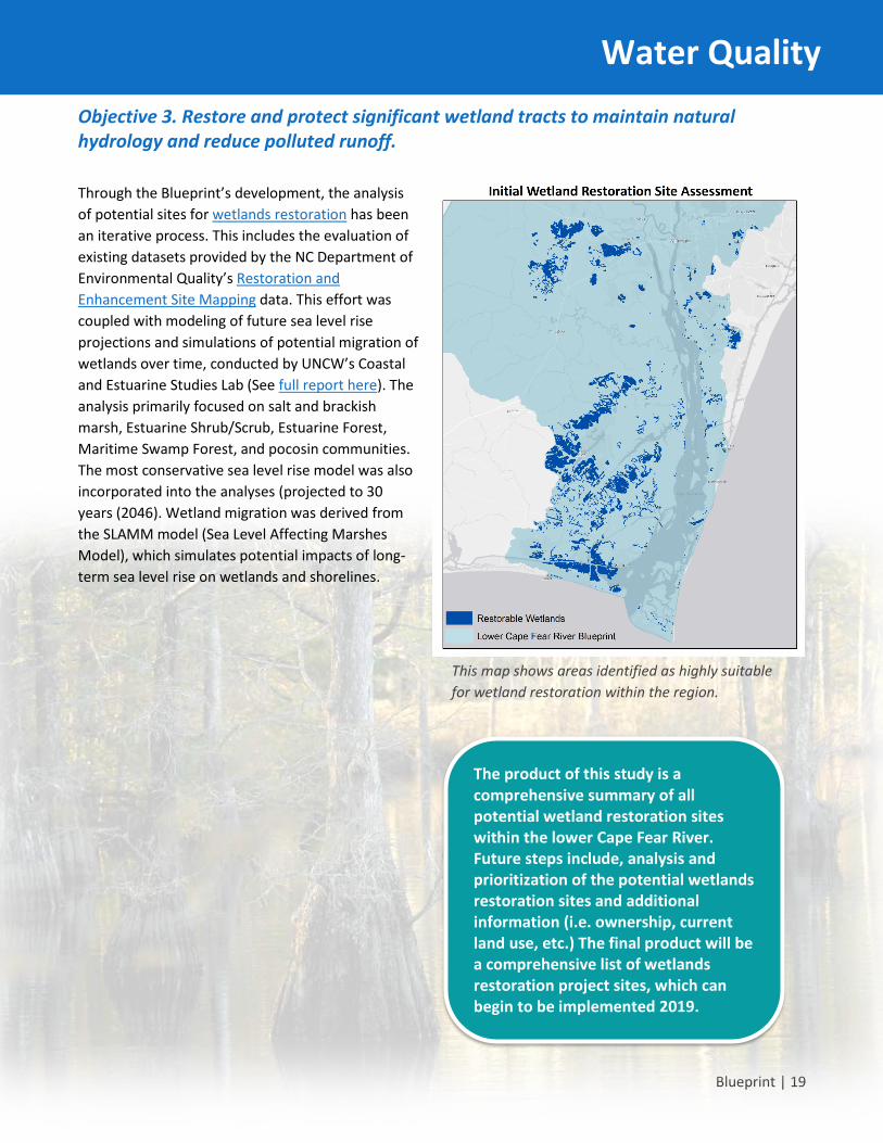
Objective 3. Restore and protect significant wetland tracts to maintain natural hydrology and reduce polluted runoff.
Through the Blueprint’s development, the analysis of potential sites for wetlands restoration has been an iterative process. This includes the evaluation of existing datasets provided by the NC Department of Environmental Quality’s Restoration and Enhancement Site Mapping data. This effort was coupled with modeling of future sea level rise projections and simulations of potential migration of wetlands over time, conducted by UNCW’s Coastal and Estuarine Studies Lab (See full report here). The analysis primarily focused on salt and brackish marsh, Estuarine Shrub/Scrub, Estuarine Forest, Maritime Swamp Forest, and pocosin communities. The most conservative sea level rise model was also incorporated into the analyses (projected to 30 years (2046). Wetland migration was derived from the SLAMM model (Sea Level Affecting Marshes Model), which simulates potential impacts of long-term sea level rise on wetlands and shorelines.
Water Quality
This map shows areas identified as highly suitable for wetland restoration within the region.
The product of this study is a comprehensive summary of all potential wetland restoration sites within the lower Cape Fear River. Future steps include, analysis and prioritization of the potential wetlands restoration sites and additional information (i.e. ownership, current land use, etc.) The final product will be a comprehensive list of wetlands restoration project sites, which can begin to be implemented 2019.

Blueprint | 20
Goal 2. Living Shorelines Have resilient Living Shorelines that protect against shoreline erosion, preserve water quality and natural estuarine functions and provide thriving habitat for fish and wildlife.
There are 12,000 miles of estuarine shorelines in North Carolina that provide some of the best fish and wildlife habitats in the world. Rising seas, storms and boat wakes are causing these shorelines to erode. In response, hundreds of miles of bulkheads and stone revetments have been installed to control erosion and protect adjacent upland properties. As a result, critical intertidal ecosystem habitats such as oyster bars, salt marshes and mudflats that would normally be present have been lost, drowned or degraded.
The North Carolina Coastal Federation and its partners promote a more effective and sustainable method to manage shorelines called living shorelines. Living shorelines are longer-term, less-expensive techniques that reduce erosion while at the same time maintain or restore the shoreline’s natural integrity and functions. Additionally, living shorelines have been shown to outperform traditional hardening approaches during storms and can cost less to construct and maintain.
As part of the Coastal Resilience Initiative, the federation and its partners are committed to streamlining the permit process for living shorelines, providing adequate education and demonstration of these sustainable project designs, and establishing cost share opportunities to encourage widespread adoption of living shoreline measures throughout the coastal region. To facilitate this process within the lower Cape Fear region, the Blueprint includes several living shoreline objectives and actions.
Living Shorelines
To learn more about Living Shorelines, click here:
Living Shorelines Academy

Blueprint | 21
Living Shorelines Objectives and Actions
Living Shorelines
• Action 1. Conduct shoreline mapping and change analyses to characterize shoreline erosion for the Lower Cape Fear River and identify hotspots of erosion.
• Action 2. Model inundation of Lower Cape Fear River based on local sea-level rise projections and identify areas of greatest risk.
• Action 3. Create composite map of sea-level rise inundation risk and shoreline change to highlight areas of high or low risk across the study area and highlight priority preservation and restoration project locations.
• Action 4. Secure funding to implement 10 highest priority living shoreline projects for 2019 and beyond to accomplish the living shoreline goals and objectives.
Objective 1. Preserve, restore, and stabilize priority estuarine shorelines that are maintained during era of increased sea-level rise (through 2045).
A homeowner opted to install a vegetation-only living shoreline instead of a bulkhead. Living shorelines can reduce erosion and help protect valuable intertidal habitat.

Blueprint | 22
Objective 1. Preserve, restore, and stabilize priority estuarine shorelines that are maintained during era of increased sea level rise (through 2045). Researchers from UNCW worked with the federation to conduct a shoreline characterization and sea level risk analysis that categorizes historical shoreline changes, current changes related to sea level rise and projected inundation. This analysis is a critical step in identifying appropriate sites for sustainable shoreline restoration and protection efforts.
The study identified portions of the Lower Cape Fear estuary shorelines most susceptible to continued erosion, the effects of sea level rise and erosional effects of commercial shipping traffic navigating between the Atlantic Ocean and Wilmington’s commercial shipping port.
Living Shorelines
Volunteers help to create a living shoreline, creating an oyster reef to provide habitat and stabilize an eroding marsh.

Blueprint | 23
Key sea level rise modeling and shoreline change analysis results: This effort was coupled with modeling of future sea level rise projections and simulations of potential shoreline change over time, conducted by UNCW’s Coastal and Estuarine Studies Lab (See full report here).
• That scenario predicts possible SLR rates of 0.4 to 1.4 m and land inundation of 10.3 to 23.2% of total land area in New Hanover and Brunswick Counties.
• Rates of shoreline change ranged from -0.06 m/yr. to -0.75 m/yr. This is like the average shoreline loss seen throughout the state of -0.5 m/yr.
• More erosion was observed along the Brunswick County shoreline than the New Hanover shorelines.
• Shoreline areas that are highly susceptible to shoreline change rates and sea level rise are highly localized.
• Low-lying wetlands are at greatest risk for long term inundation and shoreline changes.
• High rates of erosion and inundation potential exist along the western shorelines near Brunswick Town, Fort Anderson, Orton Plantation, Zekes Basin, areas of Bald Head Island, and other areas particularly along Brunswick County.
The results of the study will be used to identify existing shoreline areas that are most at risk for loss and/or degradation. From the study results, a minimum of ten (10) potential living shoreline project sites will be identified. Funding and construction of suitable living shoreline projects will be initiated in 2019.
UNCW’s Shoreline and Sea-level Rise study maps illustrate shoreline changes between 1982 to 2016 for the Lower Cape Fear River study area shorelines.
Living Shorelines
Results from the Sea Level Rise (SLR) modeling and shoreline change analysis were combined to assess vulnerability to both shoreline erosion and SLR. While there was not definitive correlation between shoreline change rate and SLR (for the different scenarios), there are clearly localized areas across the lower Cape Fear River Estuary that are highly vulnerable to both types of impacts. As inundation is directly related to land elevation, locations that are primarily low-lying wetlands exhibit the greatest inundation potential, and in many cases these areas also were found to have high shoreline change rates.

Blueprint | 24
Goal 3. Oysters Have oyster habitats thrive and support vibrant fisheries, good water quality, and resilient estuarine shorelines.
Oysters are a vital keystone species in our estuaries, providing habitat for other species and improving water quality by filtering water. Oysters serve as an important food source and part of our maritime culture. However, oyster populations have been declining in North Carolina. Some estimates indicate the population is at 10 percent of historic levels due to disease, poor water quality, historic overfishing and natural disaster. The Eastern Oyster, Crassostrea virginica, is useful in assessing the environmental health of the ecosystem. Oyster reefs provide habitat for fish, benthic invertebrates and a host of many other species. The Lower Cape Fear River estuary has been experiencing an ongoing degradation of oyster reefs due to man-made and natural processes. This decline is a result from habitat loss from overharvesting, dredging, turbidity, sedimentation, vessel traffic, polluted bacterial stormwater run-off resulting in degraded water quality and closed shellfish waters.
Since 2003, the federation has worked with NC Division for Marine Fisheries (DMF) and other partners to develop and implement the Oyster Restoration and Protection Plan for North Carolina: A Blueprint for Action. The Oyster Blueprint’s strategy of blending the latest science, cutting-edge restoration techniques, watershed protection efforts and active resource management to support healthy oyster populations will be utilized in the lower Cape Fear River.
Restoring oyster reef habitat and supporting a sustainable wild oyster fishery and oyster farming in the lower estuary of the Cape Fear is a complex and ambitious initiative, but there is reason to be optimistic. Historical navigation charts show extensive oyster reefs in the lower river. While many of those reefs are gone or buried under the river’s mud, there remain viable pockets of oyster reefs supported by an abundance of oyster larvae each year. A significant portion of the lower river, from the Fort Fisher Basin area to the mouth of river is open to shellfish harvest, and often remains open during rainfall events. The first modern shellfish lease was established in the lower river in 2011. While many challenges remain, these factors indicate the potential for a revitalized oyster population and fishery in the lower river is great.
Work has already begun on this objective. Carolina Beach State Park worked with the federation and hundreds of volunteers to construct a living shoreline using bags of recycled oyster shells. It also worked with the federation and the N.C. Division of Marine Fisheries with funds from the N.C. General Assembly and Grady White Boats to build an additional acre of reef habitat within a newly established 5-acre Artificial Reef to enhance recreational fishing and oyster habitat. In addition, plans are underway to establish additional living shoreline and oyster reef projects.
Oyster Habitat Threats • Freshets • Harvest pressure increasing • Outdated and missing habitat
mapping data • Pollution • River dredging and deepening • Sedimentation
Learn more about the Oyster Blueprint at
ncoysters.org
Oysters Oysters

Blueprint | 25
Restoring oysters in the Lower Cape Fear River estuary requires knowledge of historic and existing oyster reefs, river substrates/bottom types, water quality trends and use patterns of people working and recreating in the lower estuary. The Coastal Federation is working with the University of North Carolina Wilmington’s Center for Marine Science to initiate the process of mapping these parameters to identify appropriate sites for oyster restoration, cultch planting, and shellfish mariculture areas in the lower estuary.
Utilizing the UNCW Benthic Ecology Lab Shellfish Siting Tool and the CES Lab Shoreline and Sea-level Modeling study, the Coastal Federation and its partners have outlined a focus area for oyster restoration extending from Snows Cut downriver to Bald Head Island. The focus area is divided into two sections:
• The upriver section extends from Snows Cut to the Basin at Fort Fisher. The waters in this area are prohibited for shellfishing and are more suitable for oyster sanctuary development and habitat restoration.
• The downriver section extends from the Basin at Fort Fisher down to Bald Head Island. The waters in this area are open to shellfish harvest and more suitable for cultch planting, fishery and habitat enhancement and oyster aquaculture/mariculture.
This mapping and siting effort will identify areas in the estuary that are ecologically suited to sustain oysters and includes intensive analysis, fieldwork in the water and collaborating with other partners and experts at UNCW, the U.S. Army Corps of Engineers, N. C. Division of Marine Fisheries, N.C. Division of Shellfish Sanitation and other stakeholders. The effort will also be coordinated with the NC DMF’s Coastal Habitat Protection Plan Region 4 Strategic Habitat Assessment, which includes the lower Cape Fear River Estuary. Integrating oyster restoration efforts to the identification, protection and restoration of other important coastal habitats is critical. The emphasis is to prioritize oyster investments and projects in areas that will maximize wildlife co-benefits, including protecting habitat and providing food sources for birds and other wildlife.
Oysters
Map of shellfish harvesting area closure map and water monitoring stations.
The focus area for oyster restoration with areas outlined in green to yellow holding the greatest potential for success. This analysis was conducted by the UNCW Benthic Ecology Lab North Carolina Shellfish Siting Tool.
Constraints Most Risk Moderate Risk Intermediate Risk Low Risk Least Risk

Blueprint | 26
Oyster Objectives and Actions
•Action 1. Work with the UNCW Benthic Ecology Lab Shellfish Siting Tool, NC Dvision of Marine Fisheries (DMF) and stakeholders to identify and ground truth suitable locations for oyster sanctuaries, oyster habitat restoration and cultch planting sites based on substrate, water flow, salinity range and traditional uses.
•Action 2. Work with DMF to examine the feasability of piloting a fishermen led cultch planting program in open waters to ehance oyster habitat and support the wild fishery. Appropriate substrate is needed in the lower estuary to maintain reef habitat and sustain the wild fishery. Cultch material that is suitable for reef construction and oyster recruitment can be oyster shell, clam shell, scallop shell, marine limestone (marl), granite, or crushed concrete.
•Action 3. Work with DMF to determine the level of harvest pressure/trip tickets on oysters in the lower river to assess the amount of cultch needed to enhance oyster habitat while sustaining the wild fishery.
•Action 4. Work with Carolina Beach State Park and the Fort Fisher Recreation Area to examine the feasability of establishing seasonal stockpile sites for cultch and reef material to support large scale restoration projects and small scale fishermen led cultch planting efforts.
•Action 5. Work with Audubon NC, UNCW and other stakeholders on site selection for oyster reef construction around Important Bird Areas and the bird sanctuary islands in the lower Cape Fear River estuary, and link these projects to the planned network of oyster restoration sites.
Objective 1. Establish a network of oyster reef sanctuaries, restoration sites and cultch planting sites in the lower river.
•Action 1. Work with UNCW's North Carolina Shellfish Siting Tool, DMF and stakeholders to identify and ground truth areas suitable for oyster leasing in the approved shellfishing waters of the lower river.
•Action 2. Implement reccomendations of the UNC Collaboratory Study's Shellfish Aquaculture Plan to identify areas suitable for an "Oyster Aquaculture/Maricutlure Enterprise Zone" in the approved shellfishing waters of the lower river.
•Action 3. Work with the NC Zekes Island Coastal Reserve, NC Division of Coastal Management, National Estuarine Research Reserve and the NC Natural Heritage Program to identify appropriate shellfish aquaculture activities that can occur within the reserve.
•Action 4. Work with Brunswick County, elected officials, DMF and stakeholders to investigate the potential of adjusting the moratorium on shellfish leasing in Brunswick County to allow the development of shellfish aquaculture in the approved shellfishing waters of the lower river.
Objective 2. Support the delveopment of shellfish aquaculture/mariculture in the lower river.
Oysters

Blueprint | 27
Objective 1. Establish a network of oyster reef sanctuaries, restoration sites and cultch planting sites in the lower river.
Along the Cape Fear River, Audubon North Carolina manages seven coastal sanctuaries that protect essential habitats for waterbirds and shorebirds. With diverse habitats ranging from sand and grass to forest and marsh, this network of islands attracts flocks of waterbirds by the thousands. Species like the White Ibis and Brown Pelican boast thriving populations today because of their breeding success at these sanctuaries.
The lower Cape Fear River estuary is one of North Carolina’s most significant nesting areas for American Oystercatchers, a large shorebird that feeds on oysters, other bivalves, and invertebrates in coastal estuaries. Although oystercatcher nesting density in the lower Cape Fear River is far greater than on barrier islands, the nesting productivity is similar. This is due to a lack of suitable foraging habitat near nesting sites. The establishment of oyster reefs near nesting locations in the lower Cape Fear River would improve oystercatcher productivity. The goal of the proposed project is to create oyster reefs at strategic intertidal and shallow subtidal locations near existing American Oystercatcher habitat using bagged shell, cultch, and/or another suitable substrate.
Part of Objective 1 will be to work with Audubon NC, UNCW and other stakeholders on site selection for oyster reef construction around Important Bird Areas and the bird sanctuary islands in the lower Cape Fear River estuary, and link these projects to the planned network of oyster restoration sites.
Oysters
Some of the important rookery islands in the Lower Cape Fear River that provide critical habitat for water birds.
Blueprint | 28
Rookery Island Restoration and Protection Audubon NC maintains a series of Important Bird Areas and nesting sanctuary islands in the lower Cape Fear River. These island and sites function to provide a system of rookery islands to allow bird populations to nest, feed, and migrate, which will provide the necessary habitats for a stable population of important coastal birds who have been driven out of their natural habitats by development and other land use changes. However, these islands are under threat from erosion, sea level rise and invasive vegetation.
The aim of Audubon NC is to achieve and maintain population targets for water birds using the Lower Cape Fear River, including: American Oystercatcher, Brown Pelican,
Great Egret, Royal Terns, Least Terns, and others. The Blueprint and its stakeholders will work with Audubon NC and the state to protect habitats critical for the survival of a variety of colonial water birds and shorebirds, which depend on the lower Cape Fear River dredge spoil islands for nesting and foraging habitat. Audubon maintains a series of Important Bird Areas and nesting sanctuary islands in the lower Cape Fear River. These island and sites function to provide a system of rookery islands to allow bird populations to nest, feed, and migrate, which will provide the necessary habitats for a stable population of important coastal birds who have been driven out of their natural habitats by development and other land use changes.
• Enhancement and creation of islands through dredge spoil management and placement coordinated to enhance nesting sites for colonial water birds and other avian species. This strategy will identify what islands need restoration and mitigation from sediment management, sea level rise and erosion. These strategies will require staff, partners and regulatory coordination with the living shoreline, wetland and oyster reef restoration goals of the blueprint.
• Ensure no net loss of acreage (and sites) available on islands and near shore habitats for nesting water birds, with special focus placed on maintaining habitat within Important Bird Areas. Develop living shorelines and oyster reef projects to provide living oyster reefs for food sources and protect these habitats from erosion and rising sea levels.
• Produce a management plan that ensures the appropriate amounts and distribution of suitable habitat types on these sites to support the varying needs of nesting water birds (e.g. bare sand, minimal vegetation, shrubby habitats). Achieve and maintain population targets for water birds using the lower Cape Fear including American Oystercatcher, Brown Pelican, Great Egret, Royal Terns, Least Terns, and others.
• Identify what islands need restoration and mitigation of sediment, sea level rise and erosion by using living shorelines, wetlands and oyster reef restoration. The intention is to ensure no net loss of acreage at sites and no loss of near-shore habitats for nesting water birds, with special focus placed on maintaining habitat within Important Bird Areas. Additionally, living shorelines and oyster reef projects provide food and protection from erosion and rising sea levels. Implementation must be cognizant of suitable habitat types at sites to support the varying needs of nesting water birds (e.g. bare sand, minimal vegetation, shrubby habitats).
Oysters

Blueprint | 29
Objective 2. Support the development of shellfish aquaculture/mariculture in the lower river.
The North Carolina General Assembly in 2017 directed the UNC Collaboratory Study's Shellfish Aquaculture Plan’s stakeholder group to develop an oyster mariculture plan for the state. As part of the plan development, Mariculture Enterprise Zones (MEZ) are being discussed and evaluated. A MEZ would be an area, potentially 2 to 10 acres in size, that would be set up for leasing for oyster mariculture. The area would be pre-approved for leasing by the NC Division of Marine Fisheries. Small leases, 0.5 to 1 acres would be available for oyster growers to rent. The focus would be on new growers who are looking to get into oyster mariculture but may not have access to suitable areas to lease. The growers in the MEZ would also benefit from working side by side with other growers, and they would have access to training and other resources from NC Sea Grant and other agencies.
Oysters
Learn more about on-going efforts:
• Oyster Restoration and Protection Plan: A Blueprint for Action 2015-2020
• 2016 State of the Oyster Report • 2016 Study by RTI International
Learn more about North Carolina oysters at: NCoysters.org

Blueprint | 30
Goal 4. Invasive Species Management Protect and preserve native coastal wetlands populations that are free of the invasive species Phragmites australis. The lower Cape Fear River is experiencing increased pressure from non-native, invasive species that alter the landscape. Phragmites australis, also known as the common reed, is a non-native invasive species that poses a serious threat to natural coastal habitats, beginning to replace some native marsh communities in the Lower Cape Fear River estuary and throughout coastal North Carolina. Once Phragmites australis becomes firmly rooted, it aggressively spreads, with above ground plant heights of 10 to 12 feet, and a tough fibrous root system equal in length to the above- ground portion. Normally found in thick, dense stands, Phragmites australis can reduce the overall diversity of the native coastal marshes and alter the habitats available for the coastal North Carolina animal species normally found in this region.
Once established, Phragmites australis is very difficult to eradicate, even when treated with repeated doses of chemical herbicides, such as the widely used Roundup product. Roundup’s dominant compound constituent is glyphosate, a broad-spectrum systemic herbicide and crop desiccant. To complicate the issue, this organophosphorus compound is currently under intense worldwide scrutiny and research to determine the extent of its relative toxicity to coastal ecosystems and human health. In 2017, the federation initiated a statewide collaborative discussion around the issue of management of Phragmites australis (Workshop presentations). Current management needs include coast-wide identification and mapping, early detection programs, and development of eradication strategies that are environmentally safe and do not constitute a health risk for humans and other animals.
Invasive Species
Morgan Rudd, summer intern with the North Carolina Coastal Federation, presented on the current science on Phragmites australis at the 2017 Phragmites australis Workshop.

Blueprint | 31
Invasive Species Objectives and Actions
•Action 1. Identify existing populations of Phragmites australis and model potential hotspots and migration patterns within the lower Cape Fear Region (UNCW).
•Action 2. Seek funding opportunities to expand identification program for lower Cape Fear River region.
Objective 1: Develop an Invasives Species Identification Strategy for Phragmites australis.
•Action 1. Analyze scientific literature and established management programs to document the effectiveness of current and experimental eradication/management strategies.
•Action 2. Analyze existing scientific research on potential adverse affects to ecosystem and human health.
•Action 3. Facilitate collaboration within North Carolina's stakeholders and Phragmites australis research/management experts to share findings and identify research gaps and funding for needed research.
Objective 2. Evaluate management strategies for effectiveness and safety, with specific review of pesticide toxicity to waters, coastal ecosystems, and health of humans and animals.
•Action 1. Identify successful or experimental management techniques to manage Phragmites australis, using methods that are safe for ecosystem and human health.
•Action 2. Secure funding and collaborative support to initiate a pilot program to manage Phragmites australis, with an emphasis on isolated and emerging populations.
•Action 3. Expand program to entire region of the lower Cape Fear River.
Objective 3. Develop management program to safely and effectively manage existing and emerging Phragmites australis populations within the lower Cape Fear River watersheds.
Invasive Species

Blueprint | 32
Implementation and Next Steps The North Carolina Coastal Federation, along with numerous partners, have been working to develop the Lower Cape Fear River Blueprint for over two years. The Blueprint vision identifies the goals and objectives to restore and protect this valuable resource for generations to come. Under each major goal the Federation has identified specific actions and steps and projects to begin implementation of the Blueprint. Moving forward, the federation and our collaborators will work to identify and prioritize the specific on-the-ground and in-the-water projects, their associated costs and potential funding to implement the specific goals and actions.
This Blueprint is designed to be a living document. One of the key actions to ensure the success of the Blueprint vision will be a comprehensive and innovative outreach effort to the public, regulatory agencies, and local governments to broaden stakeholder involvement and leverage potential funding sources to implement the Blueprint goals and strategies. The Blueprint is designed primarily as a web-based interactive resource, with full access to the studies, links to additional resources, and the elements of the plan itself.
The outreach strategy will focus on telling the story of the lower Cape Fear River estuary, its beauty, resources, cultural heritage, challenges, and importance to the people of the region and the state. With better understanding of the river’s rich history and current risks to maintaining the health of this estuary, we hope to foster collaboration and support for the proposed strategies to preserve this often hidden, but invaluable backbone of the lower North Carolina region.
Reaching Success

Blueprint | 33
The staff and Board of Directors of the North Carolina Coastal Federation are grateful for the generous dedication of time, effort and expertise provided during the completion of this Blueprint by our project partners and many others.
Our project partners include: the University of North Carolina at Wilmington, including the Center for Marine Science and the Department of Environmental Sciences; Audubon North Carolina; North Carolina Shellfish Sanitation Division; North Carolina Division of Marine Fisheries; North Carolina Division of Water Resources, and other agency staff from the North Carolina Division of Coastal Management.
Consultation and coordination included: member participation from the Cape Fear River Partnership, Cape Fear Arch, Bald Head Island Conservancy, Cape Fear RiverWatch, Cape Fear River Assembly, and North Carolina Coastal Reserve Program.
Special Acknowledgements are extended to:
Asia Askew UNC Wilmington Britt Sheinbaum N.C. Coastal Federation Daniel Pate UNC Wilmington Danielle Devonport UNC Wilmington Dawn York Moffat & Nichol Devon Eulie UNC Wilmington Emma York UNC Wilmington Evan Hill UNC Wilmington James Arnuk UNC Wilmington Jatu Nugrohorukmi UNC Wilmington Mariko Polk N.C. Coastal Federation Sarah Eure UNC Wilmington Troy Alphin UNC Wilmington

Blueprint | 34
Acronyms and Definitions 303(d) List A list of water bodies that are too polluted or degraded to meet water quality
standards. 319 a grant program funded by EPA and administered by DEQ to restore impaired
waters using practices laid out in watershed restoration plans APPROVED AREA An area determined suitable for the harvest of shellfish for direct market purposes BIORETENTION AREAS
Also known as rain gardens, these provide onsite retention of stormwater through the use of vegetated depressions engineered to collect, store, and infiltrate runoff
BMP Best Management Practice of stormwater management; also commonly referred to as Stormwater Control Measure (SCM) or Stormwater Infiltration Practice (SIP)
CAFO Confined Animal Feeding Operation CATCHMENT A geographic unit within a subwatershed made up of a singular river, stream, or
branch that contributes to a larger watershed. CFU Colony Forming Unit used to measure fecal coliform concentrations CONDITIONALLY APPROVED CLOSED
An area subject to predictable intermittent pollution that may be used for harvesting shellfish for direct market purposes when restoration plan criteria are met generally during drought conditions
CONDITIONALLY APPROVED OPEN
An area subject to predictable intermittent pollution that may be used for harvesting shellfish for direct market purposes when restoration plan criteria are met, generally during low rainfall conditions
CWA Clean Water Act DCM North Carolina Division of Coastal Management DEGRADED WATERS General description of surface waters that have elevated pollution levels, could
include high bacteria levels, pathogens, sediment, low dissolved oxygen, and/or high nutrient levels. This is not a legal description of impairment (see impaired waters definition).
DEQ North Carolina Department of Environmental Quality DESIGNATED USE A Clean Water Act term referring to the use, such as recreation or aquatic life
support, that a water body has been designated with by the state. The water body may not actually be able to support its designated use.
DOT Department of Transportation EPA Environmental Protection Agency EXISTING USE A Clean Water Act term referring to all current uses and any use the water body has
been able to support since November 28, 1975. FDA U.S. Food and Drug Administration FECAL COLIFORM Bacteria that originate in the intestines of warm-blooded animals. Bacteria of the
coliform group which will produce gas from lactose in a multiple tube procedures liquid medium (EC or A-1) within 24 plus or minus two hours at 44.5 degrees C plus or minus 2 degrees C in a water bath.
FLOW The volume of water, often measured in cubic feet per second (cfs), flowing in a stream or through a stormwater conveyance system
GIS Geographic Information Systems GROWING WATERS Waters that support or could support shellfish life HUC Hydrologic Unit Code HYDROGRAPH A graph showing changes in the discharge of a surface water river, stream or creek
over a period of time

Blueprint | 35
HYDROLOGIC CYCLE The cycle by which water evaporates from oceans and other bodies of water, accumulates as water vapor in clouds, and returns to the oceans and other bodies of water as precipitation or groundwater. Also known as the water cycle.
HYDROLOGY The science dealing with the waters of the earth, their distribution on the surface and underground, and the cycle involving evaporation, precipitation, flow to the seas, etc.
IMPAIRED WATERS For the purposes of this Guidebook, any saltwater classified for shellfish harvest (SA) that is not managed as an “Approved Area” by the Division of Environmental Health, or any saltwater classified for swimming (SB) where swimming advisories are being issued. These waters have been listed as impaired on the state’s 303(d) list for EPA.
IMPERVIOUS COVER A hard surface area, such as a parking lot or rooftop, that prevents or retards water from entering the soil, thus causing water to run off the surface in greater quantities and at an increased rate of flow.
LID Low Impact Development is integration of site ecological and environmental goals and requirements into all phases of urban planning and design from the individual residential lot level to the entire watershed.
LULC Land use/land cover MAXIMUM EXTENT PRACTICABLE
According to EPA, available and capable of being done after taking into consideration cost, existing technology, and logistics in light of overall project purpose.
MS4 Municipal separate storm sewer systems NEPA National Environmental Policy Act NOAA National Oceanic and Atmospheric Administration NPDES National Pollutant Discharge Elimination System NPS Nonpoint Source, diffused sources of pollution, where there is no singular distinct
outflow point. NRCS Natural Resources Conservation Service NSSP National Shellfish Sanitation Program RETROFITTING Structural stormwater management measures for preexisting development
designed to help reduce the effect of impervious areas, minimize channel erosion, reduce pollutant loads, promote conditions for improve aquatic habitat, and correct past efforts that no longer represent the best science or technology.
ROW Right of Way SA Saltwater classified by the N.C. DEQ for shellfish harvesting. These are waters that
should support aquatic life, both primary and secondary recreation (activities with frequent or prolonged skin contact), and shellfishing for market purposes.
SB Saltwater classified by the N.C. DEQ for swimming. SC Saltwater classified by the N.C. DEQ for fish propagation and incidental swimming.
The waters are safe for swimming but have a higher risk of pollution and human illness than SB waters.
SCM Stormwater Control Measure, also more commonly known as a Best Management Practice (BMP) of stormwater management; also commonly referred to as Stormwater Infiltration Practice (SIP)
SHELLFISH SANITATION
Shellfish Sanitation and Recreational Water Quality Section, N.C. Division of Marine Fisheries, N.C. DEQ. In 2011 the N.C. General Assembly transferred the shellfish and recreational water quality functions of this agency from DEH to DMF.

Blueprint | 36
SIP Stormwater Infiltration Practice, also more commonly known as a Best Management Practice (BMP) of stormwater management; also, commonly referred to as Stormwater Control Measure (SCM)
STORMWATER Water from rain that flows over the land surface, picking up pollutants that are on the ground.
SUBWATERSHED A geographic unit within a watershed made up of individual minor rivers, streams, or branches that contribute to a larger watershed.
TMDL Total maximum daily load, the maximum amount of a pollutant that can be found in a water body and still meet federal Clean Water Act standards.
USDA U.S. Department of Agriculture USGS U.S. Geological Survey WATERSHED The topographic boundary within which water drains into a particular river, stream,
wetland, or body of water. WATERSHED All areas that drain to a waterbody, whether that be a lake, mouth of a river, or
ocean WQS Water quality standards WWTP Wastewater Treatment Plant