capsule summary ba-1521 mayfair - maryland...
TRANSCRIPT
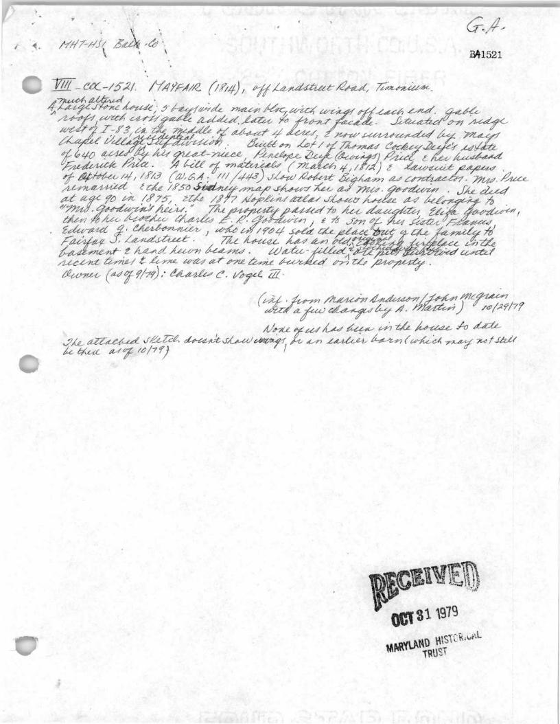
CAPSULE SUMMARY BA-1521 Mayfair 401 Landstreet Road Lutherville-Timonium, Baltimore County 1812 Private
Mayfair, erected in 1812 on land originally belonging to Thomas Cockey Deye, was the home of
Frederick Price and Penelope Deye Owings Price. Penelope Price was later remarried, taking the surname
Goodwin. The 1850 county atlas confirms Mrs. Goodwin's residency in the dwelling. Upon her death in
1875, the property passed to her heirs, first to Eliza Goodwin, and then Charles E.R. Goodwin. In 1904,
the property finally passed out of the family upon its conveyance to Fairfax S. Landstreet from then-owner
Edward G. Cherbonnier. Located in the vicinity of Cockeysville and Texas, the dwelling is representative
of Federal style houses erected throughout Baltimore County in the early 19th century.
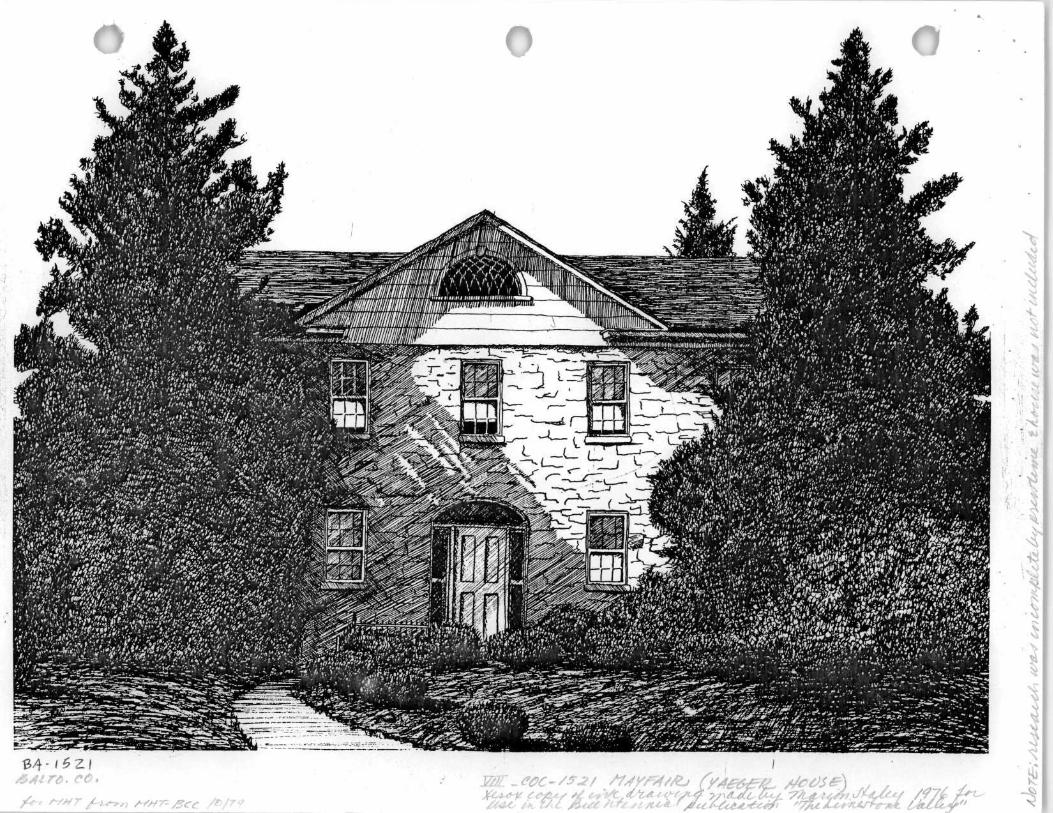
Mayfair is a two-and-a-half-story Federal style dwelling of solid random rubble stone construction
with two reconstructed interior end stretcher bond brick chimneys and a boxed wood cornice with returns.
The south side of the five-bay-wide dwelling has been augmented by the construction of a two-and-a-half-
story, two-bay-wide circa 1940 wing with a random rubble stone facade and asbestos shingle cladding on
the remaining two sides. A one-story, circa 1960 enclosed porch wing with a gable roof projects to the
north. A circa 1900 ell extends from the west elevation of the main block, which fronts east. The 1812
facade is centrally pierced by a six-panel single-leaf wood door with multi-leaded sidelights and fanlight.
The molded wood door surround is composed of paneled recess and soffit and engaged fluted columns.
Four 6/6 windows flank the entry, while five 6/6 windows pierce the second story. All openings have
square-edged wood surrounds and stone sills, while those of the second story feature brick jack-arched
lintels. The spandrels between the first and second stories of the outer bays are articulated by recessed
rectangular stretcher bond brick panels with rowlock surrounds. The attic story was altered circa 1900 by
the creation of a central intersecting gable presently clad in asbestos shingles with a multi-light fanlight
with a square-edged wood surround. Three historic resources, including a circa 1815 barn, circa 1815
chimney ruins, and circa 1940 springhouse and three non-historic resources, including a circa 1960 shed,
circca 1980 shed, and circa 1980 in-ground swimming pool, are also located on the property.
Maryland Historical Trust Maryland Inventory of Historic Properties Form
Inventory No. BA-1521
1. Name of Property (indicate preferred name)
historic Mayfair
other
2. Location street and number 401 Landstreet Road not for publication
city, town Lutherville-Timonium vicinity
county Baltimore County
3. Owner of Property (give names and mailing addresses of all owners)
name Charles C. Vogel, III and Elaine C. Vogel
street and number PO Box 161 telephone Not Available
city, town Lutherville-Timonium state MD zip code 21094
4. Location of Legal Description courthouse, registry of deeds, etc. Baltimore County Courthouse liber 5287 folio 247
city, town Towson tax map 60 tax parcel 782 tax ID number 1600007401
5. Primary Location of Additional Data Contributing Resource in National Register District Contributing Resource in Local Historic District Determined Eligible for the National Register/Maryland Register Determined Ineligible for the National Register/Maryland Register
. Recorded by HABS/HAER
Historic Structure Report or Research Report at MHT Other:
6. Classification
Category ^—district X building(s)
—.___structure —.___site
object
^ \
Ownership —.__public
X private both
Current Function —^—agriculture —-__commerce/trade —-__defense
X domestic — education
funerary government
___heal th care __industry
landscape . .recreation/culture
religion social
— transportation ____work in progress —-__unknown — vacant/not in use — -other:
Resource Count Contributing Noncontributing
buildings _— sites
structures objects Total
Number of Contributing Resources previously listed in the Inventory
1

7. Description Inventory No. BA-1521
Condition
excellent deteriorated X good ruins
_ fair altered
Prepare both a one paragraph summary and a comprehensive description of the resource and its various elements as it exists today.
Constructed in 1812, Mayfair is a two-and-a-half-story Federal style dwelling of solid random rubble stone construction with two reconstructed interior end stretcher bond brick chimneys and a boxed wood cornice with returns. The south side of the five-bay-wide dwelling has been augmented by the construction of a two-and-a-half-story, two-bay-wide circa 1940 wing with a random rubble stone facade and asbestos shingle cladding on the remaining two sides. A one-story, circa 1960 enclosed porch wing with a gable roof projects to the north. A circa 1900 ell extends from the west elevation of the main block, which fronts east. A six-panel single-leaf wood door with multi-leaded sidelights and fanlight centrally pierces the 1812 facade. The molded wood door surround is composed of paneled recess and soffit and engaged fluted columns. Four 6/6 windows flank the entry while five 6/6 windows pierce the second story. All openings have square-edged wood surrounds and stone sills, while those of the second story feature brick jack-arched lintels. Recessed rectangular stretcher bond brick panels with rowlock surrounds articulate the spandrels between the first and second stories of the outer bays. The attic story was altered circa 1900 by the creation of a central intersecting gable presently clad in asbestos shingles with a multi-light fanlight with a square-edged wood surround.
Three historic resources and three non-historic resources are also located on the property. A random rubble stone foundation and structural system with an asphalt-shingled side gable roof comprise the circa 1815 barn. The building features a posted forebay with a sash-and-paneled single-leaf door, a flush-vertical-board divided single-leaf door with lights, and three 6/6 windows.
The circa 1815 chimney ruins feature a solid random rubble stone hearth and flue. The structure appears to have been rehabilitated circa 1960 for use as a barbecue.
Dating to circa 1940 is a springhouse that is banked into the hillside to the south of the dwelling. The one-story structure features solid concrete block construction with an asphalt-shingled front gable roof. The facade is pierced by one four-light awning door with a square-edged wood surround.
The one-story shed that dates to circa 1960 features an asbestos-shingled wood frame structural system, concrete block foundation, and side gable roof clad in asphalt shingles. The facade is pierced by one sash-and-paneled single-leaf wood door and a one-light fixed wood window, both of which have square-edged wood surrounds.
The one-story wood frame shed clad in board-and-batten siding features a concrete pier foundation and asphalt-shingled shed roof. The circa 1980 building is pierced by one flush double-leaf sliding door.
A circa 1980 in-ground pool is sited to the west of the dwelling.

^ ^ ^
8. Significance Period
1600-1699 _ 1700-1799
X 1800-1899 X 1900-1999
2000-
Specific dates
Areas of Significance
X agriculture _ archeology
X architecture _ art
commerce _ communications _ community planning
conservation
1812-present
Construction dates 1812, 1900 ca., 1960
Evaluation for:
National Register
Check and justify below
economics _ education _ engineering _ entertainment/
recreation _ ethnic heritage _ exploration/
settlement
ca.
_ health/medicine _ industry _ invention
Inventory No. BA-1521
_ performing arts _ philosophy _ politics/government
_ landscape architecture religion law
_ literature _ maritime history
military
Architect/Builder
Maryland Register
science _ social history _ transportation
other:
Robert Bingham, contractor
X not evaluated
Prepare a one-paragraph summary statement of significance addressing applicable criteria, followed by a narrative discussion of the history of the resource and its context. (For compliance projects, complete evaluation on a DOE Form - see manual.)
Mayfair, erected in 1812 on land originally belonging to Thomas Cockey Deye, was the home of Frederick Price and Penelope Deye Owings Price. Penelope Price was later remarried, taking the surname Goodwin. The 1850 county atlas confirms Mrs. Goodwin's residency in the dwelling. Upon her death in 1875, the property passed to her heirs, first to Eliza Goodwin, and then Charles E.R. Goodwin. In 1904, the property finally passed out of the family upon its conveyance to Fairfax S. Landstreet from then-owner Edward G. Cherbonnier.1 Located in the vicinity of Cockeysville and Texas, the dwelling is representative of Federal style houses erected throughout Baltimore County in the early 19th century.
Joshua Cockey, the primary landowner in the area, founded the town of Cockeysville. The town is strategically located a half a mile east of the Beaver Dam marble quarries. Marble quarrying began in this region in 1780 and fully developed between 1815 and 1829. Shortly thereafter, the area's abundant limestone deposits were quarried. In 1804, the first limestone was burned in nearby Texas, Maryland. The availability of these two important stones enabled the construction of local buildings to feature marble and also limestone, although the latter was primarily used for agricultural purposes.
The early 19th century saw a great change in the town's rural character. Before the construction of the Baltimore and Susquehanna Railroad, Cockeysville was composed primarily of large farms with buildings scattered over the landscape. In 1838, the Baltimore and Susquehanna Railroad officially opened, passing through the town of Cockeysville, for travel from Baltimore to the Maryland/Pennsylvania line. The construction of the railroad through the town center enabled Cockeysville to grow into a larger community that included a wide array of commercial interests for a town of its size. By the mid-1800s, Cockeysville's commercial structures included a carriage manufacturer, carpentry shop, butcher's shop, dentist's office, distillery, and saloon. There were at least two general stores, blacksmith's shops, cobblers, and medical
Baltimore County Historic Inventory. See also J.C. Sidney, Map of the City and County of Baltimore, Maryland, from Original Surveys (Baltimore, MD: James M. Stephens, 1850); Atlas of Baltimore County, Maiyland (Philadelphia, PA: G. M. Hopkins, 1877).

Maryland Historical Trust Maryland Inventory of inventory NO BA-1521 Historic Properties Form
Name Mayfair, 401 Landstreet Road, Lutherville-Timonium, Baltimore County Continuation Sheet
Number _8_ Page 2
doctors. Compared to other towns in the vicinity, Cockeysville could have been considered rather urban in its character.2
In 1838, the Baltimore and Susquehanna Railroad officially opened, passing through the town of Cockeysville, for travel from Baltimore to the Maryland/Pennsylvania line. In 1854, the Baltimore and Susquehanna, York and Maryland, York and Cumberland, and Susquehanna Railroad Companies were consolidated into the Northern Central Railroad Company, one of the largest railroad companies in Maryland. Thus, its location near the junction of the York Road and the Northern Central Railroad enabled Cockeysville to grow continually through the latter half of the 19th century.3 In 1877, commercial properties in Cockeysville included a blacksmith's shop, a carriage manufacturer, two merchants, and a marble works.4 By 1881, the small town's population had grown to 270 people located at this important intersection. By the late 19th century, the town of Cockeysville and its vicinity had established a flourishing trade industry supported by agriculture, mills, and marble quarries.
The Heritage Committee of the Greater Timonium, The Limestone Valley (Timonium, MD: The Greater Timonium American Bicentennial Committee, 1976), p. 15. 3 J. Thomas Scharf, History of Baltimore City and County from the Earliest Period to the Present Day: Including Biographical Sketches of Their Representative Men (Philadelphia, PA: Louis H. Everts, 1881), pp. 344-345. 4 Atlas of Baltimore County, Maryland (Philadelphia, PA: G. M. Hopkins, 1877).
9. Major Bibliographical References Inventory No. BA-1521
Atlas of Baltimore County, Maryland. Philadelphia, PA: G. M. Hopkins, 1877. Baltimore County Historic Inventory. Brooks, Neal A. and Eric G. Rockel. A History of Baltimore County. Towson, MD: Friends of the Towson Library, Inc., 1979. Map of Baltimore County. Philadelphia, PA: G. W. Bromley, 1915. Scharf, J. Thomas. History of Baltimore City and County From the Earliest Period to the Present Day: Including Biographical
Sketches of Their Representative Men. Philadelphia, PA: Louis H. Everts, 1881. Reprinted by Higginson Book Company, Salem, MA.
Sidney, J. C. Map of the City and County of Baltimore, Maryland, from Original Surveys. Baltimore, MD: James M. Stephens, 1850
10. Geographical Data
Acreage of surveyed property One Acre Acreage of historical setting Unknown Quadrangle name Cockevsville Quadrangle scale: 1:24,000
Verbal boundary description and justification
Since its construction in 1812, Mayfair has been associated with the 4.997 acres of land known as tax parcel 782 of map 60 located in the Baltimore County Tax Assessor's office.
11. Form Prepared by
name/title A. McDonald and A. Didden, Architectural Historians
organization EHT Traceries, Incorporated date May 21,2001
street & number 1121 5th Street NW telephone 202.393.1199
city or town Washington state DC
The Maryland Inventory of Historic Properties was officially created by an Act of the Maryland Legislature to be found in the Annotated Code of Maryland, Article 41, Section 181 KA, 1974 supplement.
The survey and inventory are being prepared for information and record purposes only and do not constitute any infringement of individual property rights.
return to: Maryland Historical Trust DHCD/DHCP 100 Community Place Crownsville, MD 21032-2023 410-514-7600


BA-1521 Mayfair 401 Landstreet Road, Lutherville-Timonium USGS 15' quadrangle Baltimore, 1904 (surveyed 1902), showing Landstreet Road.
Alignment of former Landstreet Road.
The house currently stands within the community of Mays Chapel, which was developed in the 1970s.

BA-1521 Mayfair 401 Landstreet Road, Lutherville-Timonium Cockeysville Quadrangle
1998 Aerial Photo Tax Map 60, p. 782