carbonate-siliciclastic sedimentation on a high-energy ... · 1centro de pesquisa em geofisica e...
TRANSCRIPT

Geological Society, London, Special Publications
doi: 10.1144/GSL.SP.1999.149.01.05p55-71.
1998, v.149;Geological Society, London, Special Publications Viviane Testa and Dan W. J. Bosence ocean-facing, tropical ramp, NE BrazilCarbonate-siliciclastic sedimentation on a high-energy,
serviceEmail alerting
new articles cite this article to receive free e-mail alerts whenhereclick
requestPermission
part of this article to seek permission to re-use all orhereclick
Subscribe
Collection London, Special Publications or the Lyell
to subscribe to Geological Society,hereclick
Notes
© The Geological Society of London 2013
at CAPES on August 19, 2013http://sp.lyellcollection.org/Downloaded from

Carbonate-sil iciclastic sedimentat ion on a high-energy, ocean- facing, tropical ramp, N E Brazil
V I V I A N E T E S T A 1 & D A N W. J. B O S E N C E 2
1Centro de Pesquisa em Geofisica e Geologia, Universidade Federal da Bahia, Rua Caetano Moura, 123, Salvador, Ba 40210-340, Brazil
2Department of Geology, Royal Holloway University o f London, Egham TW20 OEX, UK
Abstract: The inner portion of the continental shelf of Rio Grande do Norte State, Brazil has been investigated by Landsat-TM imagery and by scuba diving. The area experiences high-energy, shoreline and shelf-margin parallel currents driven by a combination of oceanic, tidal and wave processes. The high meso-tidal range (<4 m) further distributes the high-energy waters over the entire inner shelf region (0-25 m). This shelf is a high-energy, distally steepened ramp in which the distribution of carbonate and siliciclastic facies belts is controlled by the energy of the environment, the sources of siliciclastic sediment and the Quaternary history of the area. Carbonate sediments are generated throughout the sublit- toral zone and are dominated by calcareous red and green algae. SmalL, low-diversity coral patch reefs occur in shallow areas. Quartz-rich sands form beaches and subaerial longitu- dinal dunes, and an offshore, submarine, sandstone outcrop interpreted as a former Qua- ternary shoreline. This sandstone has been eroded during the Holocene transgression to generate quartz sands deposited in a train of transverse dunes migrating parallel to the coast. Longitudinal sand ribbons comprising bioclastic gravelly sands attest to high-energy, shore-parallel currents in the inner shelf. Branching coralline algae (maErl) form stabilized sea-floor areas. Preliminary 14C dating indicates a Pleistocene highstand period when coarse algal sands accumulated. Holocene lowstand conditions spread quartz-rich sands over the inner ramp area, which were reworked during the Holocene transgression. Present-day erosion, transport and in situ carbonate production results in mixing of these earlier carbonate and siliciclastic units. The Brazilian ramp has similar, but narrower mor- phology, when compared with the distally steepened ramps of the Yucatan and west Florida. All three ramps are swept by coastline-parallel currents. In Brazil, the higher- energy, windward-facing, inner ramp has calcareous algal sands and patch reefs compared with the inner ramps of the leeward-facing Gulf of Mexico examples that accumulate mol- luscan sands. Outer ramp facies in each example are planktonic foraminiferal oozes.
The Brazilian continental shelf is narrow with a steep, fault-controlled cont inental slope inherited from the rifting of the Atlantic Ocean. The study area (Fig. 1) lies within the Touros High and Rio Grande do Norte Plateau of Northeast Brazil. These two structural highs are characterized by Precambrian basement with a thin cover of Cenozoic sediments (Asmus & Porto 1973; Martins & Coutinho 1981). The Cenozoic and Mesozoic sections thicken along this continental margin to the northwest into the Portiguar Basin and to the south into the Paraiba-Pernambuco Basin (Asmus & Porto 1973; Figueiredo 1985; Mello 1989). This struc- tural high is still tectonically active so that local fault-related sea-level changes are superim- posed on Quaternary glacio-eustatic sea-level changes (Srivastava & Corsino 1984; Suguio et al. 1985; Testa 1997; Bezerra et al. 1998).
The northeast Rio Grande do Norte shelf can be divided on the basis of its bathymetry into two regions. The inner shelf is a sub-horizontal to gently sloping shelf (0.8-1~ extending some
25-30 km from the shoreline to a topographic break at about 20 m depth marked by the Lithi- fled Sediment Zone (Fig. 2). Seawards, the mid- to outer shelf has a moderate slope of around 5-15 ~ which continues until about 60-80 m depth at the outer Brazilian shelf margin, where the slope increases to c. 60 ~ and descends to oceanic depths (Fig. 1).
The Rio Grande do Norte continental shelf is an open ocean facing, windward shelf, with no bays, estuaries or significant inflowing rivers. The shelf is oriented to face the full strength of the westerly flowing South Equatorial Current (Fig. 1) and this, combined with high winds and a high tidal range, makes this a high-energy, open ocean facing shelf. The shoreline is charac- terized by beach-dune complexes of relict and reworked siliciclastic sands. Despite the equato- rial, open-ocean setting the shal low-marine waters lack large reef systems, and are blanketed by a complex of mixed carbonate-siliciclastic sands and gravels composed mainly of calcare- ous red and green algae. Deep-water deposits
TESTA, V. • BOSENCE, D. W. J. 1998. Carbonate-siliciclastic sedimentation on a high-energy, ocean-facing, tropical ramp, NE Brazil. In: WRIGHT, V. P. 8r BURCHETTE, Z. P. (eds) Carbonate Ramps. Geological Society, London, Special Publications, 149, 55-71.
at CAPES on August 19, 2013http://sp.lyellcollection.org/Downloaded from

56 V. TESTA & D. W. J. BOSENCE
Fig. 1. Morphology of Northeast Brazil continental shelf and margin and location of study area (after Projeto REMAC: Margem Continental Norte 1979). Bathymetric profiles a, b and c after Martins & Coutinho (1981). Inset summarizes western tropical Atlantic currents (after Richardson & Walsh t986).
consist mainly of a hemipelagic silty clay, rich in Foraminifera (Mabesoone & Coutinho 1970; Mabesoone 1971; Francisconi et al. 1974; Milli- man & Summerhayes 1974; FranCa et al. 1976; Martins & Coutinho 1981; Testa & Bosence 1998).
This low-angle, carbonate-dominated, conti- nental shelf may therefore be categorized as a distally steepened carbonate ramp (type G of Read 1985; Burchette & Wright 1992). Its morphology is similar to other Atlantic and Gulf of Mexico margins such as the Yucatan shelf (Logan et al. 1969), the western Florida shelf (Mullins et al. 1988) and the cool temperate
northwest European shelf (e.g. Light & Wilson this volume).
O c e a n o g r a p h i c r eg ime
The marine environment in the study area is characterized by high temperatures and salinities of surface waters. Sea surface temper- ature ranges from about 26.5~ in the winter to about 28.5~ in the austral summer (Servain et al. 1990). The salinity is also typical of equator- ial and tropical environments , and varies between 36 and 37%o. The coastal waters are nutrient depleted, with low suspended-sediment
at CAPES on August 19, 2013http://sp.lyellcollection.org/Downloaded from
SEDIMENTATION ON HIGH-ENERGY RAMP, BRAZIL
STORM-DOMINATED
57
OCEANIC DOMII cURRENT~IATED
FAIR WEATHER PROCESSES
TIDE-DOMINATED WAVE-DOMINATED ,11
Tides increasingly dominant fair weather processes b.=
Oscillatory currents increasingly dominant fair weather processes
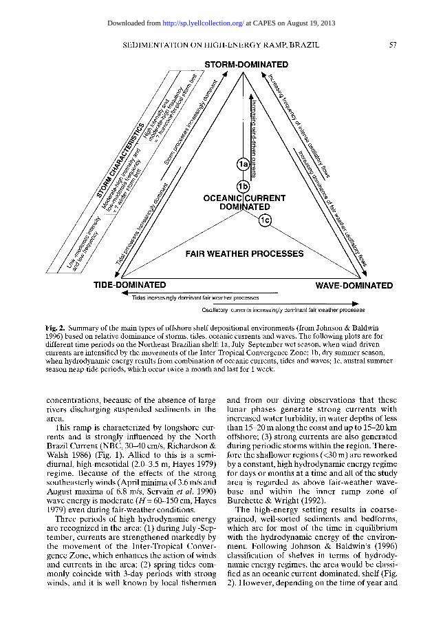
Fig. 2. Summary of the main types of offshore shelf depositional environments (from Johnson & Baldwin 1996) based on relative dominance of storms, tides, oceanic currents and waves. The following plots are for different time periods on the Northeast Brazilian shelf: la, July-September wet season, when wind-driven currents are intensified by the movements of the Inter-Tropical Convergence Zone; lb, dry summer season, when hydrodynamic energy results from combination of oceanic currents, tides and waves; lc, austral summer season neap-tide periods, which occur twice a month and last for 1 week.
concentrations, because of the absence of large rivers discharging suspended sediments in the area.
This ramp is characterized by longshore cur- rents and is strongly influenced by the North Brazil Current (NBC, 30--40 cm/s, Richardson & Walsh 1986) (Fig. 1). Allied to this is a semi- diurnal, high-mesotidal (2.0-3.5 m, Hayes 1979) regime. Because of the effects of the strong southeasterly winds (April minima of 3.6 m/s and August maxima of 6.8 m/s, Servain et al. 1990) wave energy is moderate (H = 60-150 cm, Hayes 1979) even during fair-weather conditions.
Three periods of high hydrodynamic energy are recognized in the area: (1) during July-Sep- tember, currents are strengthened markedly by the movement of the Inter-Tropical Conver- gence Zone, which enhances the action of winds and currents in the area; (2) spring tides com- monly coincide with 3-day periods with strong winds, and it is well known by local fishermen
and from our diving observations that these lunar phases generate strong currents with increased water turbidity, in water depths of less than 15-20 m along the coast and up to 15-20 km offshore; (3) strong currents are also generated during periodic storms within the region. There- fore the shallower regions (<30 m) are reworked by a constant, high hydrodynamic energy regime for days or months at a time and all of the study area is regarded as above fair-weather wave- base and within the inner ramp zone of Burchette & Wright (1992).
The high-energy setting results in coarse- grained, well-sorted sediments and bedforms, which are for most of the time in equilibrium with the hydrodynamic energy of the environ- ment. Following Johnson & Baldwin's (1996) classification of shelves in terms of hydrody- namic energy regimes, the area would be classi- fied as an oceanic current-dominated, shelf (Fig. 2). However, depending on the time of year and
at CAPES on August 19, 2013http://sp.lyellcollection.org/Downloaded from
58 V. TESTA & D. W. J. BOSENCE
the time scale of the observations, oceanic, wind and tidal currents will all have an important influence at different times of the year (Fig. 2).
This contribution introduces a case study of a present-day, open-ocean, equatorial ramp that is unusual in that it is dominated by shelf-wide algal carbonate production, and has a coastal and an offshore siliciclastic sand supply, all within a high-energy setting. The inner ramp is characterized by laterally migrating sediment bedforms, areas of patch reefs and lithified Qua- ternary lithologies. The combination of high-fre- quency Quaternary sea-level changes together with the high-energy setting means that accumu- lation rates are very low and there is a close jux- taposi t ion of highstand bioclastic carbonate sediments and lowstand siliciclastic sediments. These environmental and geological controls result in unusually complex relations between facies and depositional sequences, which serve as a model for the interpretation of ancient, ocean-facing, high-energy, inter-tropical ramp successions that have experienced high-fre- quency sea-level fluctuations.
Methods of study
This survey is based on the analysis of Landsat- TM images, which are processed to illustrate the main differences between sea-floor structures and sea-bed composition. These are revealed by their different spectral signatures of reflected radiance recorded as different grey levels in satellite images (see Solewics 1989; Vianna et al. 1991; Testa 1996; Testa & Bosence in press). The coordinates of the sampling sites were obtained
using a geographical information system (GIS), and located in the field using a global position- ing system (GPS). The images were ground- truthed by diving (120 sites; Fig. 3) and sea-floor observation and sampling. A total of five tran- sects across the shallow shelf were investigated, with a maximum distance of 31 km from the shoreline and 27 m water depth (Fig. 3). Samples were analysed by standard sieving for textural data and point-counting for grain composition data (Testa 1996). 14C dates were obtained on bulk samples of cemented lithologies that were obtained by hammer and chisel or underwater drill, and cleaned of all infauna and epifauna and present-day sediments. The samples were pre- treated with controlled acid leaching (0.5 M HC1 at 20~ and dated at the NERC Radiocarbon Laboratory, East Kilbride. No corrections have been applied to the dates.
Sedimentary zones and sediment transport on inner ramp
S h e l f zona t ion
The sediments and lithified Quaternary sand- stones and limestones of the region occur in six zones whose orientation and occurrence reflect the high-energy setting of the shelf and its Qua- ternary history. These zones are distinct and mappable from satellite images as a series of belts of carbonate and siliciclastic deposits more or less parallel to the coast and shelf margin (Testa 1996; Testa & Bosence in press) (Figs 3 and 4, Table 1).
The Coastal Zone (CZ) comprises subaerial
Table 1. Summary of main sedimentary features characteristic of the zones on NE Brazilian ramp
Large-scale Sediment Sediment Carbonate Setting feature composition texture percentage
Coastal Zone (CZ) scattered outcrops siliciclastic medium sand <6
Sublittoral Turbid Zone coral patch reefs, bioclastic coarse sand- >90 (STZ) buried reefs carbonate gravelly sand
Sand Ribbon Zone sand ribbons bioclastic coarse sand- 30 to >90 (SRZ) carbonate gravelly sand
Subaqueous Dune Zone very large dunes siliciclastic and medium sand 6 to >90 (SDZ) bioclastic coarse sand-
carbonate gravelly sand
sand plains siliciclastic medium sand <6
Algal Stabilized Zone bed of branching bioclastic coarse sand- 60 to >90 (ASZ) coralline algae carbonate gravelly sand
Lithified Sediment Zone submerged bioclastic coarse sand- >80 (LSZ) sandstone outcrop carbonate and gravelly sand
siliciclastic
at CAPES on August 19, 2013http://sp.lyellcollection.org/Downloaded from

SEDIMENTATION ON HIGH-ENERGY RAMP, BRAZIL 59
Fig. 3. Sedimentary zonation mapped from Landsat-TM image together with large-scale bedforms, sea-floor outcrop~ and reefs. Location of the sampling sites and five transects (A-E in inset) across the inner ramp, northeast Rio Grande do Norte State. Rose diagrams show the crest orientation of large-scale bedforms. CZ, Coastal Zone; STZ, Sublittoral Turbid Zone; SRZ, Sand Ribbon Zone; ASZ, Algal Stabilized Zone; LSZ, Lithified Sediment Zone; SDZ, Sand Dune Zone.
dunes and beaches of medium-grained quartz sand, with a minor carbonate content (<6%). This comes from present-day bioclastic debris together with a contribution from erosion of low (<4 m) cliffs of a marine bioclastic grainstone dated as >30 ka BP (Testa et al. 1997). These rest unconformably on outcrops of the Pliocene
Barreiras Group (Srivastava & Corsino 1984) and are interpreted to have formed in a Pleisto- cene highstand period. The Coastal Zone con- trasts with the proximal Sublittoral Turbid Zone (STZ), where present-day coralline algal and Hal imeda-r ich sands are mixed with siliciclastic sands over a relatively narrow band below the
at CAPES on August 19, 2013http://sp.lyellcollection.org/Downloaded from

60 V. TESTA & D. W. J. BOSENCE
N .~.: .
. . ' . ' . ' " " . :~:.d i;.i:'~"~ .::.~.
II x., ".i " :.:x.x.',
4O
Ho
Calcareous algal sands 1 River
Planktonic foram rich [ ] Siliciclastic rich sands I ~ sands - muds
[ ] Lithified sandstones Subaqueous dunes (4-7 m high) ~ -1L~ll~Maj ~
current Sand ribbons ~ Coral reefs " - direction
Fig. 4. Schematic block diagram of main depositional environments of inner to mid-ramp based on Landsat imagary and ground truthing along transects.
surf zone. The STZ is characterized by the occurrence of modern and sub-fossil (1000-1400 a Be) patch reefs located a few kilometres off- shore (Fig. 3). The reefs are mainly built by Siderastrea and Millepora in association with crusts of crustose coralline algae (Lithophyllum and Mesophyllum) (Testa 1997). The sub-fossil reefs are truncated, most probably because of erosion that occurred during a local sea-level lowstand during late Holocene time, and today are being gradually buried by carbonate sand (Testa 1997).
Between the coast and the patch reefs wave- rippled Halimeda-rich sands and seagrass beds are found. Offshore from the reefs are areas of abraded and reworked rhodoliths. These are generally colonized by fleshy brown or red algae.
Offshore from the STZ is the Sand Ribbon Zone (SRZ), which is characterized by large, coast-parallel sand ribbons that are tens of kilo- metres in length and hundreds of metres across (Figs 3 and 4) (Testa & Bosence in press). Both sand ribbon crests and troughs are composed of bioclastic sands and gravels. The crests are com- posed of coralline algal rich sand, whose tops are reworked by small wave-generated dunes. The troughs are characterized by the development of coralline algal maErl (branching, free-living coralline algae) and rhodolith communities (Testa 1996; Testa & Bosence in press).
The Algal Stabilized Zone (ASZ) is the next zone offshore and partially encloses the Sub- aqueous Dune Zone (SDZ) (Figs 3 and 4). The former is characterized by a stabilized bed of branching coralline algae, Halimeda gracilis and other, noncalcified, seaweeds. The SDZ is defined by the occurrence of very large, trans- verse dunes (for details, see Testa & Bosence (in press)). The subaqueous dunes are composed of siliciclastic sands, but the interdune areas have accumulations of bioclastic sediments, meadows of Halimeda incrassata and rhodoliths or coralline algal ma~rl.
The Lithified Sediment Zone (LSZ) forms the edge of the inner ramp, and comprises large (4 km • 50 km and up to 4 m high) submerged outcrops of carbonate-cemented, horizontally bedded and laminated sandstones (Figs 3 and 4). These outcrops, in depths of c. 20 m, show many features of sea-floor erosion in the form of undercutting and potholing, and are locally encrusted by coralline algae and sponges, and colonized by Halimeda and other fleshy algae. In thin section the sandstones are seen to be quartz rich, but with up to 20% Foraminifera, coralline algae and mollusc grains. They show phases of marine high-Mg calcite cementation, dissolution and low-Mg calcite cementation, which are interpreted to have occurred respectively in marine and in fresh water environments. The
at CAPES on August 19, 2013http://sp.lyellcollection.org/Downloaded from

SEDIMENTATION ON HIGH-ENERGY RAMP, BRAZIL 61
calcareous sandstones provide a bulk sample, minimum 14C date of 5540 a BP and are inter- preted to be a former Holocene lowstand beach-barrier shoreline (Testa et al. 1997). The age is regarded as a minimum because of the dia- genetic alteration of the marine bioclasts. The sands within these outcrops are petrograpically identical to those of the SDZ occurring down- stream of these outcrops, and they are thought to have been a time-limited source for the dune sands. Little erosion occurs today in the LSZ and the sandstones are partially overgrown by thin coralline algal crusts. The sands are also petro- graphically similar to those of the present day Coastal Zone despite their separation by 30 km.
Sediment transport
Analysis of Landsat images, and in situ measure- ments and observations of bedforms reveals that the sand ribbons and the transverse dunes in the inner ramp are active, and in equilibrium with the present-day hydrodynamic environment (for details, see Testa & Bosence in press). The orien- tation of the sand ribbons and the submarine dunes (Fig. 3) indicates that coast-parallel cur- rents are of prime importance in the reworking and transportation of sediments along the inner ramp (Testa & Bosence in press). However, the occurrence of symmetric wave ripples (70-120 cm spacing) with crests also orientated parallel to the coast, on the sand ribbons and on the large transverse dunes, indicates that there is also a shoreward flow of a smaller magnitude. This flow is interpreted to be a combination of waves and tides, and is responsible for the transport of sedi- ments from offshore areas of carbonate produc- tion to shallower, more siliciclastic-rich inshore areas (Testa & Bosence in press). It may also explain why the patch reefs are undergoing burial by carbonate sediments in most of the investigated reef areas (Testa 1997). The bed- forms within the area therefore indicate a complex interplay of currents, tides and waves as processes influencing sediment transport in the inner ramp environment (Fig. 2).
Texture, composition and origin o f sediments
Carbonate sediments. Despite the occurrence of different sedimentary zones the texture and composition of the carbonate sediments do not vary significantly across the inner ramp (Fig. 5). Areas of high carbonate production (troughs of sand ribbons, some interdune areas and most of the ASZ) are composed of coarse sand to
gravelly sand, related to the prolific growth of branching coralline algae. The only area with finer-grained sediments is the inshore area of transect C (Fig. 5) in the STZ inshore of the patch reefs, suggesting some degree of shelter from the more exposed offshore areas. The in situ development of rhodoliths produces a con- sistently coarser size fraction varying from -3 to -6 + (Fig. 5). The coralline algae commonly form up to 50% of the sands and their abundance is only reduced when siliciclastic grains increase in abundance. Articulated (or geniculate) coralline algal branch fragment were separately counted and these appear to be more abundant in the shallower-water sites. This probably reflects the abundance of the living plants (mainly Amphi- roa) on hard substrate areas (e.g. patch reefs in Transect C, Fig. 5) within the area. Halimeda and molluscs are also common but variable contribu- tors of granule- to sand-sized material to the sediments. It should be noted that coral frag- ments are rare, despite the coral patch reefs in the inshore region.
Because of the lack of variability in the abun- dance of the carbonate grains and the dominance by the ubiquitous calcareous algae, there does not appear to be any one locus of carbonate pro- duction within the inner ramp area investigated.
Siliciclastic sediments. Quartz sands produce the main variations in grain abundance and are mainly found along the coast and in the SDZ (Fig. 5). These sands are finer grained than the surrounding carbonate sediments and their pres- ence affects the abundance of all other carbon- ate grains. Siliciclastic pebbles have a localized contribution in offshore areas approximately at the level of the 15 m isobath and near the LSZ. Their localized occurrence and large grain size suggest these are reworked earlier deposits and are not related to the present-day terrigenous input.
There are clearly two main sources and accumulation sites for siliciclastic grains within the area. Coastal regions have a strip of quartz- rich sands that are recycled by coast-parallel transport in subaerial dunes and on beaches; there is little evidence for significant onshore-offshore transport of this sand. The off- shore transverse dune field of siliciclastic sand is largely isolated from the coastal sand (Figs 2 and 5). Transport pathways (Fig. 3) and the petro- graphic similarity of the grains indicate that the likely source for this sand is from previous erosion of the quartz sandstones of the LSZ. This supply of sand has now been cut off as the sandstones are being encrusted by coralline algae and other epibionts, and a thin, patchy
at CAPES on August 19, 2013http://sp.lyellcollection.org/Downloaded from

62 V. T E S T A & D . W. J. B O S E N C E
a)
, ~ - 2 ~) -1- N
" ~ 0
r l -
e - 3 -
~ 4 -
~ <4
b) 0
Transect C
I I I � 9 I ; ', ;O1 I ~ I I ~ ' , O ' , 0 1 I I
O O �9
_
1 1 ; g"~"~"~" " " " " " ~ . ~ " ~ " ~ " ~ ~
Sample 5 10 15 20 25 km
lOq .__.-i ~- - .~ . . . . . . . _ .
'oi "'I ......... " t~ 3 S T Z S R Z L S Z "r " ~ +
90
80
70
60
50
40
ao
20
lO
o
km
-7 r
-6 -5 r
N -4 " ~
-3 c" ,.~,_
-2 "~ " O
rr
J
, , , , . . . . . , i , , , , i �84 , , i
5 10 15 20 25
e -
v - 2
.N_. -1
0
�9 - - 1
~ 2
~ 4
0
0
100
90
80
70
60
50
40
30
20
10
0
km 0
Transect D
Tltl I t t LI I �9 �9 �9
. . . . . . . . . . . . . . . . . . . . . . . , , , , , , , , , , , , , , , , ~
' 0 ' ' ' 0 0 ' 0 ' �9 �9 �9 O � 9 O �9
' " ; " ~z;cn" " " ~ t
Sample 5 10 15 20 L I I
-7 ~" -6 Ck v
- 5
-4 " ~
- 3 r
-2 " 0 0 e -
r r
25 km
S T Z S R Z [ A S Z [ S D Z ] L S Z 't _
co N m g moo N mm F, m,o~
5 10 15 20 25
[ ] Coralline red [ ] Foraminifera tt5 Halimeda ~ Intraclasts algae [ ] Molluscs YA Worm tubes
[ ] Articulated red [ ] Bryozoans algae [[] Siliciclastics [ ] Miscellaneous
Fig. 5. Compositional variation along Transects C and D (Fig. 3) showing (a) grain-size variation of sediments and rhodolith fraction, (b) depth profiles along transects, and (c) abundance of grain types based on point counts of bulk sediment.
layer of mainly bioclastic sediments (Fig. 4) accumulates around these submarine outcrops today. The dune field today is therefore isolated from its source, and is surrounded by present- day carbonate production and accumulation.
Carbonate-s i l ic ic last ic mixing in the inner
ramp env ironment
Environments characterized by both carbonate and siliciclastic sediments are common on modern and ancient continental shelves. Differ- ent mixing processes occur that are dependent
on shelf morphology, hydrodynamic energy, the nature and abundance of carbonate-producing organisms, the nature and rate of siliciclastic supply and the geological history of the area (Mount 1984). Frequently, there is a delicate balance between carbonate and siliciclastic grain supply so that carbonate and siliciclastic facies are closely juxtaposed in ancient sequences. Within the inner ramp of Northeast Brazil carbonate-siliciclastic mixing occurs through a number of different processes that are detailed below. However, many of the carbonate-siliciclastic relations on this Brazil- ian ramp have an underlying historical control
at CAPES on August 19, 2013http://sp.lyellcollection.org/Downloaded from

SEDIMENTATION ON HIGH-ENERGY RAMP, BRAZIL 63
that is ultimately related to sediment supply and the high-frequency sea-level changes in the region.
siliciclastic sands are being reworked and transported parallel to the coast in two separate coastal and sublittoral zones.
Sediment supply on Northeast Brazilian
ramp
Carbonate sediment supply. The effects that sea- level change will have on carbonate facies depend largely on how carbonate-producing organisms cope with sea-level oscillations (Nelson et al. 1982), temperature and salinity fluctuations (Lees 1975), or sediment transport (Wilson 1979,1986,1988). Most of the carbonate production on the Northeast Brazil ramp is by the prolific development of calcareous algae rather than by corals. Evidence from the Sand Ribbon and Subaqueous Dune Zones indicates that coralline algae and rhodoliths can be easily transported, without significant damage, by moderate to strong currents. Similarly, Hal- imeda is able to colonize various loose sediment or cemented substrata (Testa 1997). This sug- gests that calcareous algae may be better able to cope with rapid sea-level oscillations in a mod- erate- to high-energy setting than would corals, which require a stable, rather than a mobile sub- strate. This may explain the abundance of cal- careous algae within an area of clear open-ocean, inter-tropical waters that might otherwise be expected to be dominated by corals (see Lees 1975). One important effect of the dominance by calcareous algae is that algal grains are produced ubiquitously throughout the inner ramp environment. There is no locus of carbonate sediment production as is found on coral-dominated carbonate platforms.
Siliciclastic sediment supply. The Northeast Brazil ramp is also unusual in that it has two separate sources of siliciclastic sand whose distributions are related to Quaternary sea-level changes. The sands are thought to have been derived originally from the underlying quartz- rich Barreiras Formation. Today sand is found in the outer part of the inner ramp, where the earlier, >5540 a BP, siliciclastic shoreline sands have been eroded to form an isolated, and time- limited, sand supply. This is considered to have been the source of the present-day subaqueous dune field. Carbonate producers have colonized, but not yet buried, the submerged outcrops of sandstones in the subsequent Holocene high- stands. Also, a present-day sand belt, slightly oblique to the present-day coast, is being transported to the northwest by coastal pro- cesses within the beach-dune system. Therefore
Processes o f carbonate-siliciclastic mixing
Mount (1984) recognized four processes associ- ated with the mixing of carbonate and siliciclas- tic deposits: punctuated mixing, facies mixing, in situ mixing and source rock mixing (Table 2). Punctuated mixing involves transfer of sedi- ments during rare high energy events such as storms; facies mixing occurs along the diffuse borders between contrasting facies; in situ mixing occurs through the autochthonous carbonate production within a siliciclastic sedi- ment; source rock mixing occurs when carbon- ate or siliciclastic material is eroded and supplied to a contrasting facies. All these pro- cesses occur in Northeast Brazil, and details of the mixing agents, the facies and the texture of the mixed sediments are given in Table 2.
The various types of mixing are not exclusive to individual zones and any one zone may have more than one type of mixing process. The rela- tive importance of the different mixing pro- cesses varies according to the environment investigated. The carbonate grains of the CZ derive from two sources (Fig. 6): stained carbon- ate grains are eroded from the Pleistocene bio- clastic grainstone cliffs (source rock mixing), and living or dead rhodoliths and their frag- ments are brought in by waves and by spring tides (facies mixing). In the STZ, facies mixing also occurs as a result of the adjacent transport of siliciclastic material from the coast and from the longshore and onshore transport of carbon- ate clasts.
The type of carbonate-siliciclastic mixture that most clearly characterizes the modern sedi- ments of the area is in situ mixing. This occurs where later Holocene highstand carbonate pro- duction generates bioclasts on and within the earlier siliciclastic sediments. The trough areas of the SDZ and the bioclastic sands around the LSZ represent examples of this (Fig. 6).
A narrow belt in the SRZ, at c. 15 m water depth and about 15 km offshore, comprises coarse bioclastic carbonates in association with bimodal coarse- and fine-grained siliciclastic sand. This mixed sediment is interpreted as a former siliciclastic deposit that is unconnected to any siliciclastic supply today. It may relate to the maximum offshore extent of the siliciclastic Bar- reiras Formation, which today outcrops locally along the coast. The absence of a supply of sili- ciclastic sediments to this area today and the prolific calcareous green and red algal growth in
at CAPES on August 19, 2013http://sp.lyellcollection.org/Downloaded from

64 V. TESTA & D. W. J. BOSENCE
b
~o
z.~
.~ o
2 ~
0
~ : ~ 0
~ -- , ' ~
0
:~ _=-~ ~ ~ ~ o ~n ~n N
' ~ r.~
~ 0
o
~ ~ ~ ~ �9 - ~ - ~ . ~ =
~'~'~ ~ 8 ~ ~ ~
~.~.~.~ ~.~ ~.~ m m ~
o ~ N ~ N
_o
~ ~ ~ : : ~ . , ~., ~ ' . ~
~ . ~ ~ g~
~ - ~ - - o ~ . -
. , , ~ ' ~ r ~.=~ .-~
""~ 0 X
~ - ~ ~ 0 . ~ == ~ n V ~ ~ 0 ~
at CAPES on August 19, 2013http://sp.lyellcollection.org/Downloaded from

SEDIMENTATION ON HIGH-ENERGY RAMP, BRAZIL 65
�9
"d
I
O
O em
=
O
O . ,...,
at CAPES on August 19, 2013http://sp.lyellcollection.org/Downloaded from

66 V. TESTA & D. W. J. BOSENCE
the area will eventually transform and bury this earlier siliciclastic deposit.
Mixing of carbonate and siliciclastic deposits is likely to be favoured in a high-energy ramp system, where the low-angle shelf profile and the high hydrodynamic energy facilitate sedi- ment transport in a variety of directions and with fewer restrictions than those found on rimmed shelves. In addition, sea-level oscilla- tions on a gently sloping ramp will repeatedly mix shoreline-derived clastic sediments, which are shifted further down ramp during relative sea-level lowstands, whereas shallow-marine carbonates will dominate in relative high- stands. Depending on the rate of sediment accumulation, these different grain assem- blages may be vertically separated as discrete stratigraphic packages when accumulation rates are high, or will be intermixed, as on the Northeast Brazilian ramp, when accumulation rates are low.
Comparisons with Recent distally steepened tropical ramps from Yucatan and west Florida We are not aware of any other inter-tropical carbonate ramps that have similar high-energy, calcareous algal facies that interdigitate with clastic sediments and are affected by such high- frequency relative sea-level changes. The Northeast Brazilian example may, therefore, be unique because of its environmental and geo- logical setting. However, there are two well- studied examples of distally steepened ramps from the inter-tropical region of the west Atlan- tic: the western Florida shelf (Fig. 7a) (Doyle & Sparks 1980; Mullins et al. 1988) and the Yucatan Peninsula (Fig. 7b) (Logan et al. 1969) which serve as useful comparisons (Table 3) that illus- trate some of the broader controls on the sedi- mentology of tropical ramps.
Morpho log i ca l and oceanographic setting
These three margins are similar in that they are all attached, distally steepened ramps, on low- relief continental margins facing into the Atlan- tic Ocean or the Gulf of Mexico. The Brazilian ramp is considerably narrower than the Yucatan and the west Florida ramps (Table 3), and the steep ramp slope is fault related and inherited from the Mesozoic Atlantic rifting. The west Florida ramp is distally steepened through the large-scale collapse of the outer ramp slope along listric faults related to the steeply sloping west Florida Escarpment (Mullins et al. 1988).
The Yucatan ramp is a drowned Cretaceous to Tertiary flat-topped shelf.
The ramps show similarities in that the domi- nant current on each of the three ramps is paral- lel to shore and ramp margin, the currents on all three ramps being generically linked to the east- erly to northeasterly flowing South Equatorial Current (SEC) (Fig. 1). The North Brazil Current (NBC), plus tides and winds-waves, is predominantly following the coast and ramp margin as it swings from a northerly flowing current in the east to a northwesterly flowing current in the west. The Yucatan ramp is affected by the Yucatan Current (a derivative of the NBC), which follows the contours westwards around the Yucatan Peninsula and is responsible for low-velocity currents (c. 1.5 cm/s) sweeping gently across the shelf (Logan et al. 1969). The northern part of the ramp is oriented to face the winter northerly and northeasterly winds and waves, but the western part of the ramp is paral- lel to these currents. The Loop Current of the western Gulf of Mexico derives from the Yucatan Current and sweeps along the western Florida ramp with surface velocities up to 200 cm/s but decreasing to 20-30 cm/s at 500 m and 4 cm/s at 1000 m (Mullins et al. 1988). Wind and wave currents are parallel to the coast, northerly in winter and southerly in the summer. Sediment transport in the inner to mid-ramp is therefore predominantly along the ramp in each of these cases.
Siliciclastic supply
The Northeast Brazil ramp is isolated from present-day clastic supply by the absence of any large inflowing rivers except to the west, where any clastic supply is transported to the west by the NBC. Quartz-rich sands derived from the Tertiary Barreiras Formation are redistributed over the inner ramp during lowstands and trapped in the shoreline, or stranded offshore during highstands. The Yucatan ramp is devoid of any significant clastic input because of the absence of large rivers and a carbonate hinter- land, but the western Florida shelf has a quartz- rich sand belt along the coast (less than c. 20 m depth), which is thought to be derived from erosion of Tertiary sands during periods of lower sea level (Doyle & Sparks 1980). Fine- grained clastic material in the outer slope is sup- plied today by easterly flowing Loop Current from the Mississippi delta region. The three ramps therefore differ in their clastic supply (Table 3), which reflects their different settings and geological histories. However, the shore- line siliciclastic deposits on the Brazilian and
at CAPES on August 19, 2013http://sp.lyellcollection.org/Downloaded from
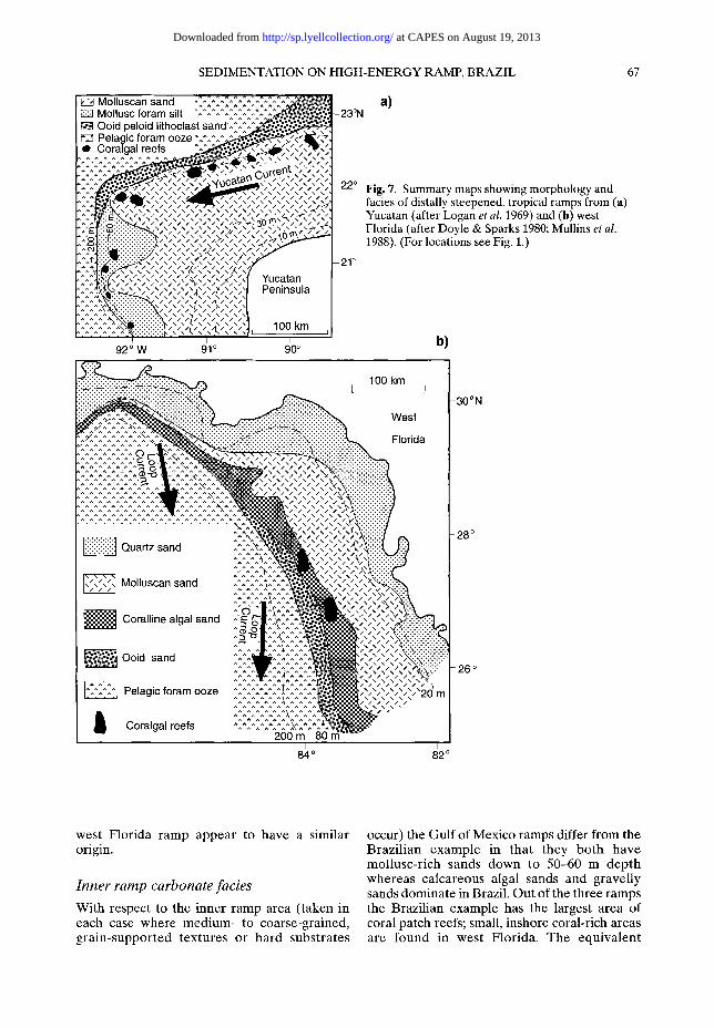
SEDIMENTATION ON HIGH-ENERGY RAMP, BRAZIL 67
E~ Molluscan sand ~^~-~,-~^~,̂ ~,̂ ~^~-~,,.,'̂ ~,~.~'~.~.~ Mollusc foram silt "-'^^~^-~-~^~,.^^:.~.~,~,~
I r~71 Ooid peloid lithoclast s a n d ' ^ ^ ~ ~ I F~ Pelagic foram ooze " ^ ^ . ~ ~ , 1 1 ~ ' ~ " ~ ] ~ Coralgal reefs ~ . . _ ~ ; , ; , ~ t l ~ , ~ , , k ~ , . ~ ^ o ^ ~ - o . . : ~ , ' , x ; , ; , ; , ; .
�9 , ~ ~ _ < . . ' , . . ' . . . ' . . . " , . . ' . . ~ ' ~ ' 0 ~ ' ~
, ^ ^ ^ ~ ~ ' , ~ , " S , ' , | Yucatan , : , . : ' t ~ ~ - ; , J Peninsula
. . . . . . ' ^ ~ ^ ^ ~ , ' , ' Z , ' , ' ~ ' J . 1 O0 km
92 ~ W 91 ~ 90 o
a) - 2 3 % 1
- 22~ F ig . 7. Summary maps showing morphology and facies of distally steepened, tropical ramps from (a) Yucatan (after Logan et al. 1969) and (b) west Florida (after Doyle & Sparks 1980; Mullins et al. 1988). (For locations see Fig. 1.)
-21 o
b)
::::::::::::::::::::::::::::::::::::: 1 O0 km
I I
~~ ̂~"~^^^^~^^~^^ ~ "-:-:.: : : : : : : : : : : : : : : : : : : : : : : : : : '....:-.'Fq.':4~.:.:.:':':':':.:-:.:
E^-^^'^^.^,:^^^^^~ ^~^'^'.'~^'^ ':i:i:i ^2^ ."~^2^~^2"~'2}~" .%'. ̂'.^ ~ ~^ ,'. ̂ !ii? ~ ^ .^ ^^^ ^^^ ~^^^^^~^ ^ ^ ^ ~ ^ ~ ^ ~ ^ ^ ' ~ ^ ,~:
Q
~ ~ a . . : , ? , ? ) Molluscan sand ~-^^^~*,^'~^,~ " , ' , ' , ' , " l:-;?;?;~ ^ ^ ~ - ~ ^ ^
/ Coralline algal sand ^ '~g . . . . ,
""* i ^H~ "" Ooid sand ,'.2,'.21 ^'2%" ;"
:::::, :::i,< Pelagic foram ooze ^~.':"-:^:^:']~'~.^,'.'2 ^ i
200 m 80 rfi
West
Florida
I Coralgal reefs
, , , , , , , , , , , , , 20 m
82 ~
tON
west Florida ramp appear to have a similar origin.
I n n e r r a m p c a r b o n a t e f ac i e s
With respect to the inner ramp area (taken in each case where medium- to coarse-grained, grain-supported textures or hard substrates
occur) the Gulf of Mexico ramps differ from the Brazi l ian example in that they both have mollusc-rich sands down to 50-60 m depth whereas calcareous algal sands and gravelly sands dominate in Brazil. Out of the three ramps the Brazilian example has the largest area of coral patch reefs; small, inshore coral-rich areas are found in west Florida. The equivalent
at CAPES on August 19, 2013http://sp.lyellcollection.org/Downloaded from

68 V. TESTA & D. W. J. BOSENCE
Table 3. Comparison of features of tropical, distally steepened ramps from Brazil (this work), Yucatan (Logan et al. (1969) and west Florida (Doyle & Sparks 1980; Mullins et al. 1988)
Northeast Brazil Yucatan West Florida
Morphology Distally steepened ramp
Width 80 km to 200 m isobath
Climate Seasonal arid to humid equatorial
Dominant current Parallel to coast and and sediment ramp margin; transport direction transport to northwest
Wind-wave Windward facing ramp; exposure southeasterly winds;
high energy
Siliciclastic Inner ramp reworked supply quartz-rich sand
Inner ramp carbonate facies
Mid-outer ramp slope facies
Outer ramp facies
Calcareous algal sand with rhodoliths with large-scale dunes and sand ribbons; coralgal patch reefs
Planktonic foram sands with increasing mud content with depth
Planktonic foram ooze >100-150 m
Distally steepened Distally steepened ramp ramp
200-250 km to 100-200 km to 200 m isobath 200 m isobath
Humid tropical Humid subtropical
Parallel to coast and ramp margin; some transport to west
Windward to leeward facing ramp; northeasterly to southeasterly winds; moderate energy
Negligible
Molluscan, intraclastic sands
Relict coralgal reefs on 60-70 m terrace with ooid, peloid lithoclast sands plus modern planktonic foram sands
Planktonic foram ooze >60-200 m
Parallel to coast and ramp margin; inner ramp transport to north (summer) and to south in (winter); ramp slope transport to south
Ramp is parallel to northerly (winter) and southerly (summer) winds; moderate energy
Quartz-rich sand reworked in inner ramp; mud from northwest carried along outer ramp slope
Molluscan, quartz sands
Relict hardgrounds and coralline algal and ooid limestones 200-400 m; winnowed planktonic foram sands 400-600 m
Planktonic foram ooze >600 m
structures on the Yucatan shelf are d rowned reefal build-ups at c. 60 m depth, reflecting its history of undi lu ted carbonate sed imenta t ion on the ramp.
This major difference in the inner ramp facies is in te rpre ted to relate to the different levels of hydrodynamic energy within the three ramps. The Brazil shelf is narrow, and faces the open- ocean winds, waves and the SEC; the inner ramp sed imen t s are act ively t r anspo r t ed by high- energy, large-scale bedforms. Coral l ine algae are seen to thrive in these condi t ions and are seen to somet imes stabilize the sea floor (e.g. A S Z and in t e r -dune and in te r - sand r ibbon troughs) and even modify some of the large- scale b e d f o r m s (Testa & Bosence in press).
Al though some molluscs can exist in these high- energy settings, they never dominate , and mol- luscan grains rarely exceed 10% abundance in Nor theas t Brazi l (Fig. 4). Similarly, shal low coralgal patch reefs are more abundant on the Brazilian ramp, which faces the open ocean, than the m o r e p ro t ec t ed Yuca tan and west Florida ramps.
Mid- to outer ramp slope
All three examples have topographic or litho- logical units re la ted to former Ho locene low- stands, but in each case they are different , reflecting the different env i ronmenta l settings and geological histories of the ramps. In Brazil
at CAPES on August 19, 2013http://sp.lyellcollection.org/Downloaded from
SEDIMENTATION ON HIGH-ENERGY RAMP, BRAZIL 69
the main lowstand feature that has been identi- fied to date is the LSZ at c. 20 m depth but it has not been precisely dated. However, its location and extent, its sediment structures and textures, and a minimum 14C age of 5540 a Be all suggest that it relates to a Holocene lowstand period. The Yucatan ramp differs because of its pure carbonate setting, and here the lowstand deposits are coralgal reefs in 50-60 m water depth surrounded inshore by molluscan and lithoclast sands, and offshore by relict (14C ages 13.32-10.93 ka BP) ooid, peloid and lithoclast sands mixed, by burrowing, with modern plank- tonic Foraminifera (Logan et al. 1969).
Although specific lowstand features have not been described from the west Florida shelf, a number of cemented Quaternary lithologies occur (planktonic foraminiferal grainstone, Lophelia coral framestone and rhodolith rud- stone) that have a maximum 14C age of c. 15 ka Be (Mullins et al. 1988). Mullins et al. showed that the outer shelf is characterized by hardgrounds with rhodolith rudstones between c. 200 and 400 m. Between c. 400 and 600 a winnowed plank- tonic foraminiferal sand occurs, and a biotur- bated planktonic foraminiferal ooze occurs beyond c. 600 m. This relatively high-energy mid-outer ramp setting in west Florida relates to the contour-hugging Loop Current, which is clearly effective in transporting sediment down to c. 600 m water depth. This current is thought to have been strengthened on this margin in mid-Miocene time, when the Isthmus of Panama was formed, which intensified the Loop Current-Gulf Stream circulation in the area (Mullins et al. 1988).
Outer ramp facies
The outer ramp deeper-water facies in all three cases are similar planktonic Foraminifera oozes suggesting similar, relatively quiet-water setting at depths >80 m (Northeast Brazil), 50-200 m (Yucatan) and >600 m (west Florida). The greater depth at which this facies occurs in Florida is due to the depth at which the Loop Current impinges on the outer slope (Mullins et aL 1988).
Conclusions
Geological and environmental setting
Because of its geological history and environ- mental setting the Brazilian ramp shows a number of unusual features. The distally steep- ened ramp inherits its profile from Atlantic margin rifting and results in a narrow (50 km)
inner to mid-ramp zone. Underlying Tertiary sandstones provide a local source for quartz-rich sands that are reworked within the Quaternary carbonate sediments. The narrow ramp profile faces the full force of the South Equatorial Current and westerly winds, resulting in a high- energy open-ocean equatorial setting in a high meso-tidal regime.
Sedimentary zones and sediment transport
The sedimentary zones from the inner ramp are characterized by subaerial dunes, beaches, patch reefs, large-scale, high-energy sand ribbons and transverse dunes generated by currents flowing parallel to the coast and ramp slope. Quartz-rich sands occur in the shoreline and offshore from the erosion of sea-floor outcrops of sandstones to form an offshore, northwesterly moving dune field. Patch reefs occur in shallow areas and locally provide shelter for the only muddy sedi- ments in the area. There are extensive areas of sea-floor cemented and stabilized coralline algal beds. All other areas accumulate a coarse coralline algal and Halimeda-rich sand with rhodoliths.
Quaternary h&tory
The location, altitude, palaeoenvironment and preliminary 14C dating of lithified units indicate three major phases in the Quaternary history of the shelf. A Pleistocene (>30 ka B~') highstand period accumulated high-energy, inner ramp cal- careous algal sands that today form <4 m high coastal cliffs. A Holocene lowstand period (>5540 a BP) drew quartz sands out over the inner ramp to form a beach-barrier complex that today lies at c. 20 m depth some 30-30 km offshore. The Holocene transgression and highstand has reworked earlier sediments, and today the area is dominated by calcareous algal sands and gravels.
Carbonate-siliciclastic mixing
High-frequency relative sea-level changes have resulted in a complex and close juxtaposition of Quaternary highstand carbonates and lowstand siliclastic facies that are being mixed in the present-day inner ramp environment. Carbon- ate-siliciclastic mixing occurs through (a) in situ growth of carbonate producing organisms in clastic sands, (b) erosion of lithified outcrops to provide limestone and sandstone intraclasts which accumulate in contrasting facies, and (c) various forms of sediment transport (waves, tides and oceanic currents) that mix historically adjacent carbonate and siliciclastic facies.
at CAPES on August 19, 2013http://sp.lyellcollection.org/Downloaded from
70 V. TESTA & D. W. J. BOSENCE
C o m p a r i s o n s with other tropical A t lan t ic
ramps
Compar i son with t ropical ramps f rom Yucatan and west Flor ida indicates that they are all dis- tally s t eepened ramps with a s lope ul t imately inher i t ed f rom A t l a n t i c - G u l f of Mexico rifting. Because these ramps are swept by the powerfu l S o u t h E q u a t o r i a l Cu r r en t , or its de r iva t ive Y u c a t a n and L o o p Cur ren t s , the low-angle , inner r amp areas are all d o m i n a t e d by coast-par- allel currents and sed iment t ransport . A l though the si l iciclastic facies on each r a m p differ because of the different na tures of their silici- clastic supply, ca rbona te facies are similar in that they are all d o m i n a t e d by mar ine , bioclastic car- bonates . H o w e v e r , the Brazi l ian inner r amp is d o m i n a t e d by calcareous algal sand, gravel and rhodol i ths , and by patch reefs, whereas the Gul f of Mexico ramps are main ly mol luscan sands. This is in te rp re ted to be a h y d r o d y n a m i c control f avour ing h igh -ene rgy algal facies in Brazil . O u t e r r a m p p l a n k t o n i c F o r a m i n i f e r a oozes occur at >80 m in Brazil, >50-200 m in Yucatan but at dep ths >600 m in west F lor ida because of the inf luence of the Loop Current .
The present research was undertaken with a CNPq grant (260178/91.8) to V.T., with fieldwork funded by the Natural Environmental Research Council, UK (GR9/12660) and the radiometric dating undertaken by the NERC Radiocarbon Laboratory (Grant 550/0993). This financial support is gratefully acknow- ledged. We also wish to thank L. Vianna, Instituto Nacional de Pesquisas Espaciais, S~o Jos6 dos Campos, Brazil, for instigating the project, provision of Landsat images, and logistical support and com- ments on this manuscript. Fieldwork was undertaken with the dedicated help of J. B. Neto ('Ded6'), C. Perrin and the fishermen of Touros and Rio do Fogo.
R e f e r e n c e s
ASMUS, H. E. & PORTO, R. 1973. Classificaqfio das bacias sedimentares brasileiras segundo a Tec- t6nica de Placas. Anais: XXVI Congresso Brasileiro de Geologia, 67-90.
BEZERRA, E H. R., LIMA-FILHO, E R, AMARAL, R. E, CALDES, L. H. O. & COSTA-NETO, L. X. 1998. Holocene coastal tectonics in Northeast Brazil. In: STEWART, I. S. & VITA-FINZI, C. (eds) Coastal Tectonics. Geological Society, London, Special Publication, 146, 279-293.
BURCHETrE, T. B. & WRIGHT, V. P. 1992. Carbonate ramp depositional systems. Sedimentary Geology, 79, 3-57.
DOYLE, L. J. & SPARKS, T. N. 1980. Sediments of the Mississippi, Alabama and Florida continental shelf. Journal of Sedimentary Petrology, 50, 905-916.
FIGUEIREDO, A. M. F. 1985. Geologia das bacias
Brasileiras. In: SCHLUMBEROER (ed.) Avaliafdo de FormafOes no Brasil. WEC Brasil, I1-I38.
FRAN~A, A. M. C., COUTINHO, P. N. & SUMMERHAYES, C. P. 1976. Sedimentos superficiais da margem continental nordeste brasileira. Revista Brasileira de GeociOncias, 6, 71-89.
FRANCISCONI, 0, COSTA, M. P. A., COUTINHO, M. G. N. VICALVI, M. A. 1974. Geologia costeira e sedi-
mentos da plataforma continental brasileira. Anais: 28. ~ Congresso Brasileiro de Geologia, Porto Alegre, 3, 305-321.
HAYES, M. O. 1979. Barrier island morphology as a function of tidal and wave regime. In: LEATHER- MAN, S. P. (ed.) Barrier Islands:from the Gulf of St. Lawrence to the Gulf of Mexico. Academic Press, London, 1-28.
JOHNSON, H. D. & BALDWIN, C. T. 1996. Shallow silici- clastic seas. In: READING, H. G. (ed.) Sedimentary Environments: Processes, facies and Stratigraphy. Blackwell Scientific, Oxford, 229-282.
LEES, A. 1975. Possible influence of salinity and tem- perature on modern shelf carbonate sedimen- tation. Marine Geology, 19, 159-198.
LIGHT, J. M. & WILSON, J. B. 1998. Cool-water carbon- ate deposition on the West Shetland Shelf: a modern distally steepened ramp. This volume.
LOGAN, B. W., HARDING, J. L., AHR, M., WILLIAM, J. P. & SLEEP, R. G. 1969. Carbonate sediments and reefs, Yucatan shelf, Mexico. American Association of Petroleum Geologists, Memoir, 11, 1-198.
MABESOONE, J. M. 1971. Calcfirios Recentes do litoral nordestino. Estudos Sedimentol6gicos, 1, 45-54.
- - & COUTINHO, E N. 1970. Littoral and shallow marine geology of northern and northeastern Brazil. Universidade Federal de Pernambuco. Trabalhos Oceanogrdficos, 12, 1-214.
MARTINS, L. R. & COUTINHO, P. N. 1981. The Brazilian continental margin. Earth-Science Reviews, 17, 87-107.
MELLO, U. T. 1989. Controles tect6nicos na estrati- grafia da Bacia Potiguar: uma integraqfio de modelos geodin~micos. Boletin de GeociOncias da PETROBRAS, 3, 347-364.
M1LLIMAN, J. D. & SUMMERHAYES, C. P. 1974. Upper continental margin sedimentation off Brazil. Con- tribuifOes a Sedimentologia, 4, 1-175.
MOUNT, J. E 1984. Mixing of siliciclastic and carbonate sediments in shallow shelf environments. Geology, 12, 432--435.
MULLINS, H. T., GARDULSKI, A. E, HINCHEY, E. J. & HINE, A. C. 1988. The modern carbonate ramp slope of central west Florida. Journal of Sedi- mentary Petrology, 50, 905-916.
NELSON, C. S., HANCOCK, G. E. & KAMP, P. J. J. 1982. Shelf to basin, temperate skeletal carbonate sedi- ments, Three Kings Plateau, New Zealand. Journal of Sedimentary Petrology, 52, 717-732.
READ, J. E 1985. Carbonate platform facies models. Bulletin, American Association of Petroleum Geologists, 68, 1-21.
RICHARDSON, P. L & WALSH, D. 1986. Mapping clima- tological seasonal variation in the surface currents of the tropical Atlantic using ship drifts. Journal of Geophysical Research, 91, 10537-10550.
at CAPES on August 19, 2013http://sp.lyellcollection.org/Downloaded from

SEDIMENTATION ON HIGH-ENERGY RAMP, B R A Z I L 71
SERVAIN, J., SILVA, M. & RUAL, P. 1990. Climatological comparison and long-term variations of sea surface temperature over the tropical Atlantic Ocean. Journal of Geophysical Research, 95, 9421-9431.
SOLEWICS, R. 1989. Fei~Oes fisiogr6ficas submarinas da plataforma continental do Rio Grande do Norte visiveis por imagen de sat~lite. MSc dissertation, Instituto Nacional de Pesquisas Espaciais, S~o Jos6 dos Campos, Brazil.
SOUZA, S. Z. 1982. Atual iza~o da litoestratigrafia da Bacia Portiguar. Anais 32 ~ Congresso Brasiliero do Geologia, Salvador, 5, 2392-2406.
SRIVASTAVA, N. K. & CORSINO, A. R. 1984. Os carbon- ates de Touros, petrografia e estratigrafia. Anais 11 ~ Simposioso de Geologia do Nordeste, Natal, Brazil, 165-176.
SUGUIO, K., BITTENCOURT, A. C. S. P., DOMINGUEZ, J. M. L., FLEXOR, J. M. & AZEVZDO, A. E. G. 1985. Fluc- tuaq6es do nivel relativo de mer durante or Quar- tern~irio Superior, ao longo do litoral brasiliero e suas implacaq6es sedimentaqao costiera. Revista Brasiliera de Geoci~ncias, 15, 273-286.
TESTA, V. 1996. Quaternary sediments of the shallow shelf, Rio Grande do Norte, NE Brazil. PhD thesis, Royal Holloway University of London.
- - 1997. Calcareous algae and corals in the inner shelf of Rio Grande do Norte, NE Brazil.
Proceedings 8th International Coral Reef Sym- posium, Panama, 1,737-742.
- - & BOSENCE, D. W. J. in press. Physical and bio- logical controls on the formation of carbonate and siliciclastic bedforms on the Northeast Brazil shelf. Sedimentology.
- - - , BOSENCE, D. W. J. & VIANNA, M. 1997. Sub- merged lithologies and their relation with relative sea-level oscillations in Rio Grande do Norte, NE Brazil. VI congresso da ABEQUA e reunido sobre o Quaternario na America do Sul, Curitaba, Pr. Brazil, 155-160.
VIANNA, M. L., SOLEWICKS, R., CABRAL, a . ~ TESTA, V. 1991. Sandstream on the northeast Brazilian Shelf. Continental Shelf Research, 2, 509-524.
WILSON, J. B. 1979. Biogenic carbonate sediments on the Scottish continental shelf and on Rockall Bank. Marine Geology, 33, M85-M93.
- - 1986. Faunas on tidal current and wave-domi- nated continental shelves and their use in the recognition of storm deposits. In: KNIGHT, R. J. & MCLEAN, J. R. (eds) Shelf Sands and Sandstones. Canadian Society of Petroleum Geologists, Memoir, II, 313-326. 1988. A model for temporal changes in the faunal composition of shell gravels during a transgres- sion on the continental shelf around the British Isles. Sedimentary Geology, 60, 95-105.
at CAPES on August 19, 2013http://sp.lyellcollection.org/Downloaded from