carboniferous petroleum systems around the mid north sea
TRANSCRIPT

1
Carboniferous petroleum systems around the Mid North Sea High, UK.
Authors: A. Monaghan*1, S. Arsenikos1, M Quinn1, K Johnson1, C Vincent2, C Vane2, A Kim2, C Uguna2, S Hannis1 ,C
Gent2, D Millward1, T Kearsey1 , P Williamson2.
*Lead author – [email protected]
1British Geological Survey, The Lyell Centre, Research Avenue South, Edinburgh, EH14 4AP, UK
2British Geological Survey, Nicker Hill, Keyworth, NG12 5GG, UK
Keywords: Visean, Namurian, source, reservoir, seal, trap, gas, oil
Highlights:
Extensive mapping of variably mature, dominantly gas-prone Visean–Namurian source rocks
Evidence for widespread Visean–Namurian petroleum system elements
Modelling indicates Palaeozoic and Cenozoic oil and gas generation from Carboniferous basins
Kilometres thick succession offers intraformational reservoirs, seals and structural traps
Abstract
The existence of an extensive, prospective Visean–Namurian Carboniferous petroleum system in and around the
hitherto under-explored Mid North Sea High is documented. Evidence is drawn from integrated analysis of over
50,000 line kilometres of seismic data and well data, together with regional source rock screening, reservoir analysis
and basin modelling.
Visean-Namurian marine and non-marine mudstones and coal source rocks are interbedded within fluvial and
marine reservoir sandstones within a stacked succession up to 5 km thick. Source rocks are dominantly gas-prone
with oil-prone intervals, and have reached oil to gas maturity levels dependent on location. Burial/thermal history
modelling indicates a kitchen area on the southern margin of the Mid North Sea High with northwest and
northeastwards migration of gas and oil during Mesozoic and Cenozoic times. A variety of structural and
stratigraphic traps are possible, including intraformational Carboniferous traps, with a regional seal at Permian
(Zechstein) level. Synthesis of many previously unpublished datasets demonstrates the Visean–Namurian play south
of the Mid North Sea High as part of an extensive petroleum system from the East Irish Sea, across onshore to
offshore UK and into The Netherlands sector of the North Sea. The purpose of this synthesis is to highlight future
exploration opportunities beneath and northwards of the productive Westphalian Southern North Sea gas basin, and

2
to begin to de-risk the petroleum systems that are exemplified by the lower Carboniferous Breagh Field in a frontier
area of the mature North Sea province.
1 Introduction
For both maximum economic recovery and security of energy supply, the UK Government and Oil and Gas Authority
advocate extending the life of the mature North Sea province. This paper synthesises regional datasets in a
previously under-explored area to highlight a petroleum system beneath and northwards of the existing, world-class
Southern North Sea gas province, potentially extending the life of the mature UK North Sea province into a frontier
area.
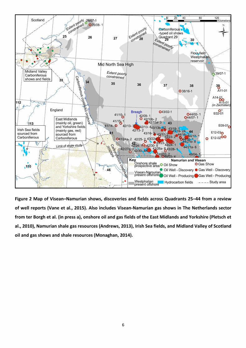
The Breagh Field (blocks 42/12a, 42/13a; Figures 1, 2), with total recoverable reserves estimated at 19.8 billion cubic
metres (699 billion cubic feet) gas (DEA Group, 2015), proves a working petroleum system in older Visean–Namurian
age strata than in the highly productive Westphalian strata predominant in the Southern North Sea gas province
(Figures 1, 2; Cameron et al., 2005; Kombrink et al., 2010; Symonds, 2015; Symonds et al., 2015; Underhill, 2003).
The spatially extensive Visean–Namurian succession subcrops at the base Permian unconformity on the southern
margin of the ‘Mid North Sea High’ (Collinson, 2005) and has been seismically interpreted in Quadrants 29, 37, 38
and 39 of the UK Continental Shelf (UKCS) (Hay et al., 2005; Milton-Worssell et al., 2010), leading to suggestions of a
potentially prospective petroleum system in these lower–middle parts of the Carboniferous succession (e.g. Milton-
Worssell et al., 2010). Lessons learned from exploration and production within the Southern North Sea Westphalian–
Permian play, such as the challenges of seismic interpretation beneath Zechstein evaporites, complex structure and
correlation of sandstones lacking biostratigraphic control (Besly, 2005; Cameron et al., 2005), combined with sparse
datasets and lack of regional geological knowledge, had led to Visean–Namurian Carboniferous petroleum systems
being viewed as frontier and risky (e.g. Besly, in press).
Consultation following a major review of the UK oil and gas industry by Wood (2014) identified certain Devonian and
Carboniferous potential plays of the UKCS as of top significance for building regional digital datasets and stimulating
exploration, to maximise economic recovery. Together with the UK Government-funded seismic survey of the Mid
North Sea High (MNSH) released in 2016 and the UK Government 29th Offshore Licensing Round, the 21st Century

3
Exploration Roadmap (21CXRM) Palaeozoic Project (2014-2016) contributed to increased exploration activity of the
‘frontier’ MNSH region. This paper is a regional scale synthesis of the prospective Visean–Namurian petroleum
systems evidenced in detail in the 21CXRM Palaeozoic project datasets and explanatory reports released in 2017*.
This work incorporates released and unreleased data, including thousands of previously unpublished
biostratigraphic, geochemical and core sample analyses, to begin to challenge some of the ‘founding myths’ (Besly,
in press) of Carboniferous prospectivity.
The study area covers Quadrants 25–44 of the UKCS (Figures 2, 3), encompassing the geographical area termed the
‘Mid North Sea High’ that separates the Southern and Northern Permian basins. The ‘MNSH’ is loosely defined and
of varying extent within published maps and literature. The term is best applied at Permian level as the area includes
a number of underlying Devonian–Carboniferous basins. A Carboniferous relative high is present under the southern
part of Quadrant 26, Quadrants 27, 28 and northern parts of Quadrants 34, 35, 36 (e.g. Arsenikos et al., 2015, in
press; Figures 2, 4), though the paucity and quality of data makes definition of its full extent difficult. Within this
paper the term ‘Mid North Sea High’ is used in its loose geographical sense, with study sub-areas referred to as
shown on Figure 3. Western European stage and substage timescale names are used, with early/lower and
late/upper Carboniferous used informally.
*downloads available from http://www.bgs.ac.uk/research/energy/petroleumGeoscience/explorationRoadmap.html

4
Figure 1 Summary of upper Devonian, Carboniferous and Permian stratigraphy with potential source,
reservoir and seal rocks indicated along with existing hydrocarbon fields. Note that the Cleveland Group
includes the Upper Bowland Shale. The stratigraphy found in the north and east of the study area is
broadly on the right hand side, the stratigraphy in the south and west of the study area is broadly on the
left hand side.
1.1 REGIONAL EVIDENCE FOR A VISEAN–NAMURIAN PETROLEUM SYSTEM AND SYSTEM ELEMENTS
Visean and Namurian oil and gas fields, discoveries and shows in Quadrants 25–44 of the UKCS are dominantly
located on the southern margin of the MNSH and are part of an extensive, connected swathe of hydrocarbon-related
finds of a similar age (Figures 2, 3). They link up eastwards into the Netherlands sector, and extend westwards
across the UK (incorporating onshore oil and gas fields of the East Midlands and Cleveland Basin and prospective
onshore UK shale gas resources) and into the Carboniferous-sourced, Triassic-reservoired fields of the East Irish Sea
(Figure 2). Situated north of the Westphalian gas basin, the data collation from offshore well reports (Vane et al.,

5
2015) summarised in Figure 2 presents evidence for a Visean–Namurian petroleum system and/or Visean-Namurian
petroleum system elements.
The East Midlands oil fields (Figures 1 and 2) are largely sourced from Namurian basinal shales (DECC, 2013;
Kombrink et al., 2010; Pharaoh et al., 2011; Pletsch et al., 2010), with Namurian and Westphalian channel-sandstone
reservoirs, and have been producing for many years. Several Namurian-sourced gas fields occur in the Cleveland
Basin in Permian reservoirs (DECC, 2013; Pletsch et al., 2010), onshore from Quadrant 41 (Figure 2). Significant
onshore shale gas resources have been estimated within the Namurian basinal shales (Andrews, 2014) and these
rocks also form the source for the East Irish Sea oil and gas fields (Armstrong et al., 1997). Gerling et al. (1999)
highlighted the likely contribution of a mature Namurian basinal source rock in addition to Westphalian Coal
Measures to gas fields of the Southern North Sea.
A working petroleum system also exists to the north of the Mid North Sea High as evidenced by Carboniferous oil
and gas shows in the Forth Approaches (Quadrant 26), together with shows and the previous Midlothian, D’Arcy-
Cousland fields in the Midland Valley of Scotland (Figure 2). Oil and gas production in the Midland Valley of Scotland
was sourced from, and trapped in, lower Carboniferous strata (Hallett et al., 1985; Underhill et al., 2008).
Prospective shale gas and shale oil resources have also been mapped within the Visean and Namurian succession
(Monaghan, 2014).
The hydrocarbon shows and fields within thick Visean and Namurian lacustrine, fluvio-deltaic and marine successions
(Figure 2; Monaghan et al., 2015; Vane et al., 2015) highlight that source, reservoir and seal rocks exist within both
structural and stratigraphic traps, as well as being potential source rocks for younger Westphalian and Permian
reservoirs. Data summarised in this paper provides further evidence for both a prospective Visean–Namurian
petroleum system and for Visean-Namurian petroleum system elements across Quadrants 25–44.
6
Figure 2 Map of Visean–Namurian shows, discoveries and fields across Quadrants 25–44 from a review
of well reports (Vane et al., 2015). Also includes Visean-Namurian gas shows in The Netherlands sector
from ter Borgh et al. (in press a), onshore oil and gas fields of the East Midlands and Yorkshire (Pletsch et
al., 2010), Namurian shale gas resources (Andrews, 2013), Irish Sea fields, and Midland Valley of Scotland
oil and gas shows and shale resources (Monaghan, 2014).

7
2 Datasets and methodology
This paper synthesizes information from a set of nine detailed, evidence-based reports that were
peer-reviewed by industry and Oil and Gas Authority experts during the 21CXRM Palaeozoic Project.
An interpretation of key stratigraphic boundaries and faults from over 50,000 kilometres of regional
2D long-offset seismic data and selected 3D surveys (Figure 3) was presented by Arsenikos et al.
(2015, in press). These were tied to re-interpreted well data in order to map an extensive Visean–
Namurian aged basin fill of fluvio-deltaic, lacustrine and marine mudstones, siltstones, sandstones,
limestones and coals (Kearsey et al., 2015, in press). Well data are sparse, with many wells
terminating just into the Carboniferous succession. Gravity and magnetic studies constrained basin
geometries further in areas of wide seismic data spacing, and delineated areas of granitic and other
igneous intrusions (Arsenikos et al., in press; Kimbell and Williamson, 2015).
Rock-Eval and vitrinite reflectance source rock data from variable vintage legacy well reports, papers
and donated datasets were tabulated, and combined with 150 new BGS analyses, to result in more
than 2500 rows of data for upper Palaeozoic samples from 76 wells (Figure 4; Vane et al., 2015).
Regional screening was undertaken on a well by well basis to examine source rock quality, remaining
hydrocarbon generation potential, maturity etc. and linked to text descriptions of kerogen type and
geochemical typing studies (Vane et al., 2015). However, given the spatial and downhole sparsity of
sample data, 31 well logs were also petrophysically analysed to offer a more continuous depth range
output than the geochemical sample analyses (Gent, 2015). This provided an indication of the
percentage of shale and total organic content with depth (Figure 3). Source rock, seismic and well
interpretations were combined in a thermal and burial basin history modelling study using
BasinModTM 1D and 3D (Vincent, 2015).

8
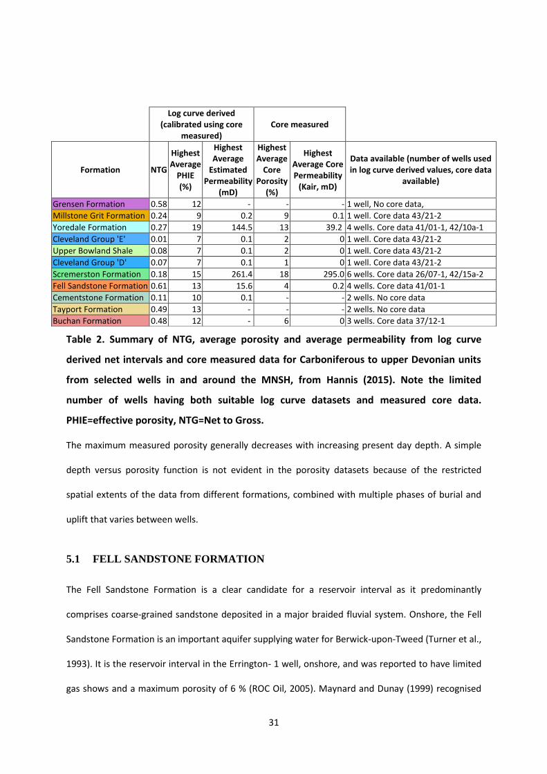
Porosity and permeability data were tabulated from legacy well reports of tests on core samples
from over 100 wells (Hannis, 2015). To further characterise Carboniferous and Devonian reservoir
intervals, the core data were used to calibrate continuous (along borehole) petrophysical well log
analyses to calculate net to gross (porosity>5%, clay volume <50% cut off), porosity and permeability
(permeability transforms were calculated on a well-by- well and formation-by-formation basis using
the Robust Fit regression method in IP™) of potential reservoir intervals (Hannis, 2015; Figure 3).
The various datasets were integrated and synthesised to a petroleum system analysis (Monaghan et
al., 2015), which is summarised in this paper. The methodology focussed on gathering of basic
geological datasets and regionally-consistent interpretations to enable future block-scale studies,
rather than a play fairway or common risk segment mapping approach.
Figure 3 Data coverage of 2D seismic datasets and wells penetrating pre-Permian strata,
together with the study areas discussed in the text. 3D seismic data used in Quadrants 28,

9
29, 30, northern 37–39, 42 is not shown. Note that the study used released and
unreleased seismic data prior to the completion of the 2016 Government seismic data
(not shown) over the Mid North Sea High. Wells used in petrophysical studies of Total
Organic Carbon (Gent, 2015) and porosity and permeability (Hannis, 2015) are highlighted.
The interpretational confidence is extremely variable, relating to both data density and data vintage
and quality. Seismic data were chosen for their penetration and reflectivity of Palaeozoic intervals,
however variable data quality impacts confidence e.g. beneath areas of complex halokinesis
(Arsenikos et al. 2015, in press). The most sparse data coverage and lowest confidence is over the
dashed area of the MNSH, whereas the densest data coverage and highest confidence is for the
southern MNSH margin (Figure 3).
3 Overview of Palaeozoic petroleum systems in and
around the Mid North Sea High
3.1 OVERVIEW OF CARBONIFEROUS BASINS
A range of Carboniferous basin orientations, depths and thicknesses have been mapped in and
around the MNSH, strongly influencing basin fill, basin history and potential prospectivity (Figure 4;
Arsenikos et al., 2015, in press; Vincent, 2015). In southern parts of Quadrants 37 and 38,
Carboniferous units onlap the southwestern margin of the Dogger Granite High and pass westwards
and southwards to a series of basins and local highs (Figure 4). The Breagh Field and Crosgan
discovery are located on one of these highs (Figure 4). In Quadrants 43–44 the mapped top
Scremerston Formation dips steeply to 5 km depth, beneath the younger Carboniferous strata of the
Silverpit basin (Figure 4). Recent studies by Rodriguez et al. (2014), Parsons (2015) and Patruno et al.
(2017) have also considered the hydrocarbon potential of the lower Carboniferous play around parts
of this southern margin of the Mid North Sea High. Farther to the south and west towards the

10
onshore Cleveland Basin (Quadrants 41 and 42) insufficient resolution of seismic data at
Carboniferous levels precluded interpretation. Seismic interpretation further to the north in
Quadrants 34–36 delineated the offshore extension of the Northumberland Trough and a series of
NW-trending faults (Figure 4), although this area is very poorly constrained by well ties (see
Arsenikos et al., 2015, in press).
Figure 4 Summary structural overview of the Devonian and Carboniferous basins and
highs discussed in the text. The location of wells studied for source rock geochemistry
(Vane et al., 2015) and basin modelling (Vincent, 2015) are highlighted.
A lower Carboniferous ‘Quadrant 29’ basin, unproved by well penetrations, was mapped from
seismic data in the southern part of Quadrant 29 by Hay et al. (2005). Seismic and gravity data

11
interpretations by Milton-Worssell et al. (2010) illustrated the continuation of this basin to the
south-east into Quadrants 37, 38 and 39, south-west of the Auk-Flora ridge. Situated outside the
area of Jurassic source rock, Hay et al. (2005) noted the correlation between the occurrence of gas
chimneys and shallow gas in southern Quadrant 29 within the mapped basin, and suggested a deep
thermogenic, Carboniferous source for the gas. Using independent well log and stratigraphic re-
interpretations and an extensive seismic dataset, the extent of the Quadrant 29 and North Dogger
Devonian and Carboniferous basins have been further delineated as significant Palaeozoic structural
elements (Figure 4: Arsenikos et al., 2015, in press). The structural configuration continues in The
Netherlands sector where Carboniferous basins have been mapped to the north-east and south-
west of the Elbow Spit High (EBN 2015 a,b; ter Borgh et al., in press a,b).
To the north of the Mid North Sea High, the Forth Approaches Basin is mapped as a complex half-
graben structure with Carboniferous strata reaching depths of around 3 – 4 km. Together with a
Carboniferous basin in Quadrant 25, these structures form an en-echelon continuation of the
onshore Midland Valley of Scotland (Figure 4; Arsenikos et al., 2015, in press).
A key finding of the regional seismic mapping is the extent of Visean (Holkerian–Asbian) coal and
mudstone source rocks of the laterally equivalent of the Scremerston, Firth Coal formations and
Cleveland Group, at depths of around 3– 5 km. They were found to extend from the southern Mid
North Sea High and Silverpit Basin, to the North Dogger and Quadrant 29 basins, and within the
Forth Approaches Basin (grey shaded extent of Visean-Namurian succession on Figure 2; Arsenikos
et al., 2015, in press.
3.2 PALAEOZOIC PETROLEUM SYSTEM ELEMENTS
A number of Palaeozoic petroleum systems or system elements can be defined around the Mid
North Sea High (Quadrants 25–44) including the productive Westphalian and Permian plays of the
Southern North Sea (Figure 5). This paper highlights interpretations of a Visean–Namurian ‘clastic

12
play’ and a coeval, siltstone-mudstone, marine-dominated ‘basinal play’ (Figures 1, 5, 6). The clastic
play comprises fluvio-deltaic, lacustrine and periodic shallow marine environments within the Fell
Sandstone, Scremerston, Yoredale and Millstone Grit formations (proved in Quadrants 26, 29, 36–39
and northern parts of blocks of Quadrants 41–44), and the basinal play the Cleveland Group
including the Upper Bowland Shale (southern parts of Quadrants 41–44; Figures 1, 5, 6). The spatial
extents of the kilometres-thick successions are controlled by both depositional facies, as highlighted
in palaeogeographic reconstructions from the Arundian to Pendleian (Kearsey et al., 2015, in press),
and erosion at the latest Carboniferous–early Permian Variscan Unconformity (Figure 5).
Similar to the Westphalian Coal Measures, Visean–Namurian strata (Fell, Scremerston, Yoredale,
Millstone Grit formations and the basinal Cleveland Group units) are commonly heterolithic and the
younger units are cyclical, responding to variations in sea level, tectonics and sediment supply.
Mudstone, carbonaceous mudstone, coal, oil shale and bituminous limestone source rocks occur in
close proximity to reservoir rocks - mainly coarse channel sandstones or estuarine and coastal
sandstones. Intraformational seals could be provided by extensive mudstones.
An overview schematic cross-section from the south to the east of the Mid North Sea High (Figure 5)
highlights the vertically stacked and laterally equivalent Palaeozoic petroleum system elements.
Intraformational Carboniferous traps and seals could be extremely important within the Visean-
Namurian clastic and basinal plays. Structural and dip traps of faulted/folded Carboniferous strata
against the base Permian unconformity and seal (Zechstein evaporites) are the primary trap/seal
mechanism envisaged. High quality Permian reservoirs (e.g. the Auk and Leman sandstones) are also
located beneath the Zechstein seal in some parts of the study area.

13
Figure 5 Overview schematic cross-section of Visean-Namurian plays and other Palaeozoic
petroleum system elements from Quadrants 38–43, the approximate line location is
shown on Figure 4.
Figure 6 3D schematic block diagram of the generalised structure and lowstand
depositional environments in the Scremerston/Yoredale formations across Quadrants 35–
44. The topography in the diagram is exaggerated to highlight the features. In reality,
sedimentation is interpreted to have kept pace with tectonism such that fault scarps
would not likely have been exposed.. During highstands, marine incursions occurred
across the fluvio-deltaic plain.

14
The lower Carboniferous clastic play is also a key part of the structurally-controlled Palaeozoic
petroleum system in the Forth Approaches, north of the MNSH. Coal, mudstone and thin oil-shale
source rocks are present within the Visean Firth Coal/Scremerston Formation (Figure 7; see also
Bruce and Stemmerik, 2003). Clastic reservoirs of mid–late Carboniferous or Rotliegend age and
possible Zechstein carbonate reservoirs are capped by Zechstein evaporites, often strongly affected
by halokinesis, which likely form an effective seal (Figure 7). Local intraformational mudstone seals
within the Carboniferous are possible and were effective onshore in trapping hydrocarbons and
form the Midlothian Field in the faulted D’Arcy-Cousland anticline (Hallett et al., 1985).
Figure 7 Summary schematic cross section of the Forth Approaches Carboniferous–
Permian petroleum system, the approximate line location is shown on Figure 4.
The evidence for prospective petroleum system elements sourced by, and within the Visean–
Namurian succession follows a summary of the overlying Carboniferous (Westphalian) and Permian
petroleum systems.
3.2.1 Westphalian petroleum system of the Southern North Sea
The Southern North Sea (SNS) gas fields form part of a major gas-producing Carboniferous and
Permian petroleum province located to the south of the Mid North Sea High (Figures 1, 2, 3). They

15
are located above and south of Visean–Namurian petroleum system elements and of relevance to
them. SNS gas accumulations were sourced from Westphalian coals, with some possible
contributions from Namurian marine shales (Gerling et al. 1999; Kombrink et al., 2010). Gas
generation is thought to have been widespread until Mid-Jurassic times with renewed generation
and migration during the Neogene (Pletsch, 2010). Migration is believed to be local, from coal source
beds into sandstones. Long range northwards migration of Westphalian-sourced gas has previously
been hypothesized, into Visean-Namurian reservoirs within Quadrant 42 (e.g. RWE Dea, 2011b). No
geochemical typing data have been located and this paper describes mature Visean and Namurian
source rocks, suggesting that long range migration of Westphalian-sourced gas is not required.
Fields with Westphalian sandstone reservoirs include Ketch, Schooner, Caister and Murdoch with an
uppermost Namurian Millstone Grit reservoir in the Cavendish Field (Cameron et al., 2005; Kombrink
et al., 2010).
Dip and fault closures adjacent to the base Permian unconformity and Permian seal rocks form a
major trap type on NW-SE/WNW-ESE and NE-SW structural trends (Cameron et al., 2005; Fraser and
Gawthorpe, 1990; Pletsch et al., 2010). Some intraformational Carboniferous sealing by mudstones
has been documented e.g. in the Boulton field (Kombrink et al., 2010).
3.2.2 Permian reservoirs and seals
The Permian Rotliegend and Zechstein groups contain proved reservoir and seal intervals across the
SNS, and are an important part of the petroleum system for Visean-Namurian sourced
hydrocarbons. Permian age hydrocarbon fields lie predominantly within Rotliegend Group
reservoirs, for example the Leman, Indefatigable and Ravenspurn fields of the Southern North Sea
gas basin, as well as the Cygnus field (Breunese et al., 2010; Catto et al., 2017; Taggart, 2015;
Underhill, 2003). In Quadrants 35–39, the Rotliegend Group is thin or absent across the MNSH
dividing the Southern and Northern Permian Basins (e.g. Gast et al., 2010; Underhill, 2003).

16
Gas discoveries (Ralph Cross, Westerdale) have also been made in onshore equivalents of the
Zechstein Group Plattendolomit (Underhill, 2003) as well as offshore in the Plattendolomit (Wissey,
Hewett fields; Peryt, 2010). Patruno et al. (2017) summarise the Zechstein reservoir potential of the
MNSH area.
The regional top seal to Rotliegend and Carboniferous reservoirs is provided by Zechstein evaporites.
Thicknesses of the evaporite facies can vary from less than 50 m to over 1500 m, and is often highly
variable due to halokinesis (Cameron et al., 1992a). Regional mapping indicates the thinnest
Zechstein succession occurs in the southern parts of Quadrants 30, 31 and northern parts of
Quadrants 38, 39 (see Monaghan et al., 2015 fig 19). The desert playa Silverpit Formation
(Rotliegend Group) comprises shales and evaporites that act as a local seal in the Silverpit–Cleaver
Bank area (Cameron et al., 1992b; Underhill, 2003).
4 Visean–Namurian source rocks
Within the lithologically mixed Visean–Namurian succession, source-rock potential is offered by
common organic-rich mudstone and coal, and rarer oil-shale and bituminous limestone (Monaghan
et al., 2015; Vane et al., 2015; Vincent, 2015). Vane et al. (2015) screened Rock-Eval sample data on
a well-by-well basis to show that source-rock quality varied from poor to excellent, with the
Scremerston, Yoredale, Millstone Grit formations, Cleveland Group and time-equivalent units (Figure
1) all exhibiting source rock potential. Most of the rocks examined were gas-prone, with some oil-
prone intervals. A summary of the variability in source rock properties by geographical area is given
in sections 4.1–4.4.
Pseudo Van Krevelen plots show mixed Type I–IV kerogens, with dominant Type III (humic, vitrinite)
(e.g. Figures 8a, 10), consistent with well reports of visually or geochemically analysed kerogens (e.g.
Kaye, 1995; Sauer, 1993). Well report analyses of migrated hydrocarbons, shows and fluid inclusions

17
highlight that a non-marine Carboniferous source is the most commonly geochemically-typed (e.g.
Farris et al., 2012; Premier, 2008). A marine-typed Carboniferous source is also documented (e.g.
Pittion 1981; summary in Vane et al., 2015).

18
Unit Number
of wells
used
Average TOC for all
mudstone intervals
(calculated wt %)
Fraction of
mudstone with
TOC >1 wt%
Average thickness
(m) of mudstone
with TOC > 1%
Coal Measures Group 7 0.8-3.3 0.08-0.61 46.1
Millstone Grit
Formation
12 1.4-2.7 0.01-0.71 239.5
Yoredale Formation 8 1.1-3.4 0.37-0.74 294.8
Scremerston
Formation
10 1.4-4.1 0.20-0.65 175.0
Cleveland Group (incl.
Upper Bowland Shale)
6 1.4-3.4 0.40-0.98 678.1
Upper Bowland Shale 6 1.4-3.4 0.64-0.93 57.6
Table 1. Summary of petrophysical log derived properties for Carboniferous source
rock formations from Gent (2015). Note that in several wells total drilling depth (TD)
was reached within the unit meaning average thickness values are underestimated.
Coals were excluded from the analysis.
Continuous petrophysical log analysis of mudstone intervals using the Passey method (Passey et al.,
1990) and calibrated to Rock-Eval data showed the highest percentage of calculated Total Organic
Carbon (TOC) >1% in the Cleveland Group, with broadly similar results for the Yoredale and
Scremerston formations (Table 1; Gent, 2015).
The following sections provide more detail on the variability of spatially and temporally
extensive source rock intervals within the Scremerston, Yoredale and Millstone Grit formations
and Cleveland Group.
4.1 SOUTH OF THE MID NORTH SEA HIGH
Collinson et al. (1995) highlighted the dominantly gas-prone source rock potential of the Yoredale
and Millstone Grit units in the north of Quadrants 41–43 and in Namurian basinal mudstones,
siltstones and marine bands in southern parts of Quadrants 41–43. Dolan and Associates (1994), Hay
et al. (2005) and Parsons (2015) also consider the Scremerston Formation to be a coal-bearing, gas-
prone source rock interval in this area.

19
20
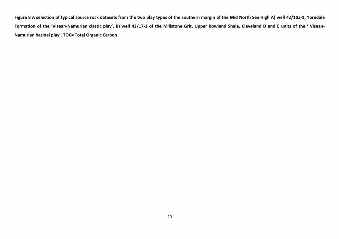
Figure 8 A selection of typical source rock datasets from the two play types of the southern margin of the Mid North Sea High A) well 42/10a-1, Yoredale
Formation of the ‘Visean-Namurian clastic play’, B) well 43/17-2 of the Millstone Grit, Upper Bowland Shale, Cleveland D and E units of the ‘ Visean-
Namurian basinal play’. TOC= Total Organic Carbon

21
Analysis of new and legacy data from wells on the northern parts of Quadrants 41–43 identified a
number of wells with gas-prone intervals, good to excellent source rock potential in the Yoredale
and Scremerston formations (e.g. 42/10b- 2, 41/15- 1, 42/09- 1, 42/10a- 1 e.g. Figure 8a) and
maturity levels ranging from oil to gas mature. Commonly these data indicate good quality source
rocks which are immature to oil mature (e.g. Figure 8a), and would offer hydrocarbon potential if
similar strata were more deeply buried in adjacent basins.
Wells in central and southern parts of Quadrants 41–43 (e.g. 41/14-1, 41/20- 1, 43/17- 2) have thick
(up to c. 2 km proved) fair to excellent TOC-rich successions within the Cleveland Group that exhibit
generally low S2 (an indicator of remaining hydrocarbon generative potential) values (e.g. Figure 8b).
The mudstone-dominated unit of the Upper Bowland Shale which has characteristically high gamma
ray wireline signature is within this Group (Kearsey et al., 2015, in press; see Figure 9). Samples vary
from oil to gas mature, to overmature, suggesting that some depletion of the source rock could have
occurred due to hydrocarbon generation. This is supported by peaks in the S1 index (a measure of
free oil and gas content) and production index (PI; Figure 8b), and by basin modelling (section 7).
These data indicate gas-mature source rocks that may have generated some hydrocarbon and may
now be depleted or overmature at deeper levels. A contributory factor to low S2 values may also be
the large proportion of woody and inert kerogens referred to in some well reports (e.g. Sauer, 1992
in 43/21- 2).

22
Figure 9 Example of the Upper Bowland Shale at outcrop, in a quarry at Bleasdale,
Lancashire [British National Grid 358880, 445040]. An onshore analogue for basinal
mudstones offshore in southern parts of Quadrants 41–43. ~30 cm long hammer, bottom
left for scale. BGS Photo P213491 BGS©NERC. All Rights Reserved 2016.
Petrophysical analysis showed that basinal Cleveland Group strata have average TOC contents
between 1.5 – 3.4 weight (wt) %. Between 64 – 98 % of the stratigraphic unit comprises mudstone
with TOC levels greater than 1 wt % (Table 1). In some wells (e.g. 43/17-2) the calculated total
thickness of Cleveland Group mudstone with a TOC >1 wt% is more than 1400 m (Gent, 2015).
Whereas particular units, such as marine bands or the Upper Bowland Shale are particularly organic
rich, it is notable that there is a very thick succession of rocks which have a fair to good source rock
quality. Measurements from 6 wells in the Yoredale Formation clastic play on the southern margin
of the MNSH indicate average TOC contents of mudstone between 1.8 – 3.4 wt % with 50 – 74 % of
the unit containing mudstone with TOC levels greater than 1 wt %. Similar values were obtained for
5 wells in the Scremerston Formation on the southern side of the MNSH with a 34 – 65 % mudstone
succession with average TOC 1.3 – 4.1 wt%. For 12 wells penetrating the Millstone Grit Formation, 1
– 71 % of the unit was mudstone with average TOC 1.4 –2 .7 wt% (Table 1). The mudstone intervals
within these units are commonly tens of metres thick and calculated thickness of mudstone with
TOC values > 1 wt % is commonly between 100 – 500 m (Gent, 2015).

23
4.2 NORTH DOGGER AND QUADRANT 29 BASINS
The Scremerston Formation was mapped into the Quadrant 29 basin based on characteristic
reflectivity (Arsenikos et al., 2015, in press; Hay et al., 2005). A Palaeozoic source for the gas
chimneys identified in Quadrant 29 by Hay et al. (2005) was not clear during seismic interpretation
of more recent data by Arsenikos et al. (2015; in press). There are no well penetrations beneath the
Permian to prove Carboniferous strata in the Quadrant 29 basin. Several wells in Quadrant 29 have
oil shows in the Rotliegend Auk sandstone (29/20-1, 29/18-1 (weak gas shows), 29/23-1, 29/25-1) or
Zechstein (29/20-1, PA Resources, 2011). Geochemical typing of samples from wells in this area
interprets oil from 29/20-1 to be from an early mature Carboniferous lacustrine (not Devonian)
source using biomarker analysis (Copestake et al., 2009). Isotopic signatures on shows and inclusions
in 29/10-3st1 were attributed to a Carboniferous coal-bearing source in Farris et al. (2012).
Carboniferous well penetrations at the margins of the North Dogger Basin encountered weak gas
shows in 38/16-1 and poor oil shows in 39/07-1 (Amoco Petroleum, 1967; Hay et al., 2005). In the
adjacent Netherlands sector along the same structural configuration, gas and oil shows are present
in wells e.g. A15-01, A14-01 north of the Elbow Spit high, distant from a Jurassic source (Figure 1;
EBN, 2015a, b; ter Borgh et al., in press a). Schroot et al. (2006) and ter Borgh et al. (in press a)
document pre-Westphalian prospectivity in this region. Arfai and Lutz (2017) report a Visean-
Namurian source rock for the A6-A gas field in the adjacent German sector and illustrate spatially
variable modelled maturity levels.
Source rock quality for the Scremerston Formation was judged to be excellent in 38/18-1, poor to
excellent in 38/16-1, and gas-prone with some oil-prone intervals (Vane et al., 2015; e.g. Figure 10a).
In 39/07-1 significant thicknesses of coal occur in the Scremerston Formation. Oil window maturity
levels were measured at Scremerston and/or Yoredale Formation source rock level in the basin
margin wells sampled (e.g. VR= 0.39-0.66 38/16- 1; see also Vane et al., 2015; Figure 10a).

24
Petrophysical calculations on the few Visean–Namurian well penetrations, indicate a less mudstone-
and less organic-rich succession than those in Quadrants 41–43. For example, three wells in the
Scremerston Formation (38/16-1, 38/18-1, 39/07-1) gave average calculated TOC of 1.4 – 2.5 wt%
with only 20 – 39 % of the succession being mudstone >1 wt% TOC (Gent, 2015). There are however,
significant coals, e.g. over a total of 20 m of coal in 39/07-1. These findings are in agreement with
the lithological well analyses of ter Borgh et al. (in press a) who describe a similar ‘overfilled clastic
play’ along strike in The Netherlands sector, passing basinward to a ‘starved shale play’ south and
east of the Elbow Spit High.

25

26
Figure 10 Typical source rock datasets from A) well 38/16- 1, Scremerston Formation of the ‘Visean-Namurian clastic play’, margin of the North Dogger
Basin B) well 26/08-1, of the Firth Coal=Scremerston units of the ‘Visean-Namurian clastic play’, Forth Approaches Basin.

27
4.3 MID NORTH SEA HIGH
Samples from two wells (36/13-1 and 36/23-1) show that the source rock potential of the Yoredale
Formation in this area is judged to be good to excellent (e.g. S2 commonly in tens and up to 160
mg/g), and mainly gas-prone with some oil-prone intervals (Vane et al., 2015). However, maturity
levels only reached pre-oil to oil levels in the analysed samples.
Petrophysical calculation of TOC content in the Yoredale Formation from 36/13-1 gave mudstones of
average 2 wt% TOC, with 37 % of the unit containing mudstone with TOC > 1wt% (Gent, 2015). As
coals are present but were excluded from the petrophysical analysis, these summary values are
pessimistic indicators of source rock presence. No other Carboniferous source rock units were
penetrated or analysed in wells across the MNSH (Quadrants southern 26–37).
4.4 FORTH APPROACHES BASIN
The Scremerston/Firth Coal Formation forms the source rock in the Forth Approaches Basin, with gas
and oil shows in well 26/08- 1 (Mobil North Sea Ltd, 1992, 1993). Coals form a significant
component of the succession, which is age-equivalent of the Scremerston Formation to the south
and east of the MNSH, and the organic-rich, oil-prone lacustrine West Lothian Oil-Shale Formation of
the onshore Midland Valley of Scotland (Cameron 1993 a, b; Kearsey et al., 2015; Loftus and
Greensmith, 1988, Parnell, 1988). Westphalian strata, age-equivalent to the Coal Measures, are
recorded in well 26/08- 1 and though mudstone intervals are present, coals are lacking.
Source rock quality of the largely gas-prone Firth Coal/Scremerston Formation varies from poor to
excellent in 26/07- 1 and 26/08- 1 with oil window maturity levels indicated in the sampled wells
(Figure 10b; Vane et al., 2015).

28
Petrophysical calculation on the Firth Coal/Scremerston Formation interval datasets from 26/07- 1
and 26/08- 1 gave an average TOC content of mudstones of 1.6 – 3.0 wt% with 44 – 45 % of the unit
containing mudstone with TOC> 1wt% (coals excluded; Gent, 2015).
5 Visean–Namurian reservoir rocks
Major, stacked channel sandbodies and palaeovalley fills within the Fell Sandstone, Scremerston,
Yoredale and Millstone Grit formations have been documented previously as potential reservoir
intervals (Collinson and Jones, 1997; Collinson, 2005; Jones, 2007; Maynard and Dunay, 1999). Using
onshore exposures of age-equivalent strata (e.g. Figure 11) and offshore borehole data, Jones (2007)
interpreted the largest stacked major channel systems to be up to about 27 m thick and up to 8 km
wide, with net to gross commonly > 0.8.

29
Figure 11 Visean multistorey channel sandstone forming the cliff at Marshall Meadows
Bay, Berwick-upon-Tweed [British National Grid 398169,657040], an analogue for offshore
reservoir sandbodies. The top of the Scremerston Formation is marked by the limestone
which occurs within the grassy interval in the cliff above the lowest thick sandstone.
The reservoir interval in the Breagh Field comprises Visean channel sandstones within the Yoredale
Formation (RWE Dea, 2011a; Symonds et al., 2015). Symonds et al. (2015) also highlighted the
reservoir role of Yoredale Formation sheet sandstones intervals across a 17 km well correlation
panel in and around the Breagh Field, with permeabilities of 0.1 – 100 mD given.
On the southern margin of the MNSH, transgressive quartzitic sandstones and low-kaolinite
sandstones form a relatively high permeability reservoir target in Namurian and early Westphalian
successions (Blackbourn and Collinson, 2006; Collinson and Jones, 1997). Millstone Grit Formation
sandstone is the reservoir in the Trent and Cavendish fields in southern parts of Quadrant 43

30
(Cameron et al., 2005; Kombrink et al., 2010; O’Mara et al., 2003). Onshore studies of Millstone Grit
Formation sand bodies to turbidite-fronted deltas (Church and Gawthorpe 1994, Hampson 1997,
Jones and Chisholm 1997) offer insight to offshore Visean-Namurian sand body geometry and
correlation, though lack of correlative chronostratigraphic data and large well spacing precluded
detailed study offshore.
Regional screening of potential reservoir-rock intervals was undertaken using petrophysical
techniques calibrated with measured core data, to identify intervals with the greatest net to gross
and porosity values throughout the succession (Figure 3; Hannis, 2015). Though only 12 wells had
suitable log curves and only 7 had measured core data, it was possible to quantify the most
favourable reservoir quality occurring within sandstones in the Yoredale, Scremerston and Fell
Sandstone formations (Table 2). Core measured porosity is variable, reaching up to 26% in the
Scremerston Formation in 26/07-1, though permeabilities are generally less than 20 mD , with rare
exceptions up to 1460 mD. .
31
Table 2. Summary of NTG, average porosity and average permeability from log curve
derived net intervals and core measured data for Carboniferous to upper Devonian units
from selected wells in and around the MNSH, from Hannis (2015). Note the limited
number of wells having both suitable log curve datasets and measured core data.
PHIE=effective porosity, NTG=Net to Gross.
The maximum measured porosity generally decreases with increasing present day depth. A simple
depth versus porosity function is not evident in the porosity datasets because of the restricted
spatial extents of the data from different formations, combined with multiple phases of burial and
uplift that varies between wells.
5.1 FELL SANDSTONE FORMATION
The Fell Sandstone Formation is a clear candidate for a reservoir interval as it predominantly
comprises coarse-grained sandstone deposited in a major braided fluvial system. Onshore, the Fell
Sandstone Formation is an important aquifer supplying water for Berwick-upon-Tweed (Turner et al.,
1993). It is the reservoir interval in the Errington- 1 well, onshore, and was reported to have limited
gas shows and a maximum porosity of 6 % (ROC Oil, 2005). Maynard and Dunay (1999) recognised
Log curve derived
(calibrated using core measured)
Core measured
Formation NTG
Highest Average
PHIE (%)
Highest Average
Estimated Permeability
(mD)
Highest Average
Core Porosity
(%)
Highest Average Core Permeability
(Kair, mD)
Data available (number of wells used in log curve derived values, core data
available)
Grensen Formation 0.58 12 - - - 1 well, No core data,
Millstone Grit Formation 0.24 9 0.2 9 0.1 1 well. Core data 43/21-2
Yoredale Formation 0.27 19 144.5 13 39.2 4 wells. Core data 41/01-1, 42/10a-1
Cleveland Group 'E' 0.01 7 0.1 2 0 1 well. Core data 43/21-2
Upper Bowland Shale 0.08 7 0.1 2 0 1 well. Core data 43/21-2
Cleveland Group 'D' 0.07 7 0.1 1 0 1 well. Core data 43/21-2
Scremerston Formation 0.18 15 261.4 18 295.0 6 wells. Core data 26/07-1, 42/15a-2
Fell Sandstone Formation 0.61 13 15.6 4 0.2 4 wells. Core data 41/01-1
Cementstone Formation 0.11 10 0.1 - - 2 wells. No core data
Tayport Formation 0.49 13 - - - 2 wells. No core data
Buchan Formation 0.48 12 - 6 0 3 wells. Core data 37/12-1

32
the reservoir potential offshore stating Net to Gross (NTG) exceeding 0.70 and Hay et al. (2005)
summarised porosity data indicating a range of 5 – 19 %.
In the wells examined for the petrophysical study in the southern MNSH margin, the Fell Sandstone
Formation has a NTG ranging from 0.34 – 0.82 with calculated average porosity ranging from 6 – 13
%. However, the largest average estimated permeability is 16 mD (Hannis, 2015). Core material from
the Fell Sandstone Formation in 43/02- 1, has an average porosity of 13 % and average horizontal
permeability of 18 mD (Redwood Corex, 1989).
5.2 YOREDALE AND SCREMERSTON FORMATIONS
On the southern MNSH margin, petrophysical screening of 3 wells (41/01-1, 42/10a-1, 43/21-2),
showed that relatively large average calculated porosities of up to 12 % were found in parts of the
Yoredale Formation. Despite a NTG of up to 0.31, the net has relatively high estimated
permeabilities, averaging 144.5 mD in 41/01-1. In the Scremerston Formation the largest average
calculated porosity is 12 % (based on 3 wells, 41/01-1, 42/15A-2, 44/02-1), but it has a relatively low
NTG of 0.24 (Hannis, 2015).
Petrophysical screening of well 39/07-1 at the margin of the North Dogger Basin has shown the
Yoredale Formation to have average calculated porosity of 13 % and NTG of 0.26. Values for the
Scremerston Formation include an average calculated porosity of 15% and NTG of 0.49 in 38/18-1.
The relatively low NTG in the Scremerston and Yoredale formations and variable but locally high
porosity-permeability is compatible with the interbedded and laterally variable lithologies that
include incised valley fill, channel and sheet sandstone facies.
In the Forth Approaches, the main reservoir target in this area is likely to be the Rotliegend Auk
Formation sandstones that are 150 m thick in 26/07- 1 with core-measured porosities of 6 – 24 %
and permeability up to hundreds of millidarcies. Additional potential reservoirs are present
throughout the heterolithic Carboniferous succession. Relatively high porosity and permeability
33
values of the Firth Coal/Scremerston Formation core samples (Table 2) in 26/07- 1 were from cores
taken from 5 – 15 m thick sand bodies.
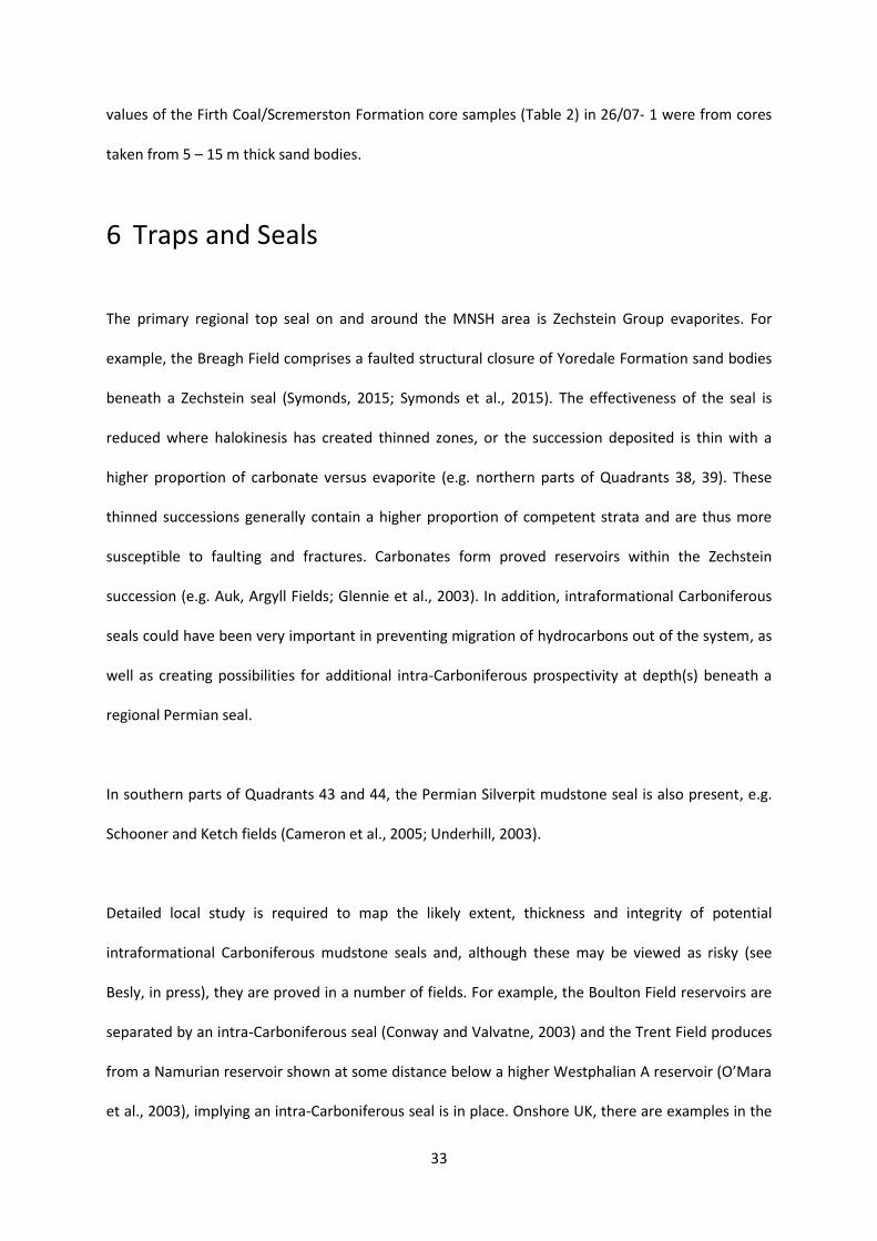
6 Traps and Seals
The primary regional top seal on and around the MNSH area is Zechstein Group evaporites. For
example, the Breagh Field comprises a faulted structural closure of Yoredale Formation sand bodies
beneath a Zechstein seal (Symonds, 2015; Symonds et al., 2015). The effectiveness of the seal is
reduced where halokinesis has created thinned zones, or the succession deposited is thin with a
higher proportion of carbonate versus evaporite (e.g. northern parts of Quadrants 38, 39). These
thinned successions generally contain a higher proportion of competent strata and are thus more
susceptible to faulting and fractures. Carbonates form proved reservoirs within the Zechstein
succession (e.g. Auk, Argyll Fields; Glennie et al., 2003). In addition, intraformational Carboniferous
seals could have been very important in preventing migration of hydrocarbons out of the system, as
well as creating possibilities for additional intra-Carboniferous prospectivity at depth(s) beneath a
regional Permian seal.
In southern parts of Quadrants 43 and 44, the Permian Silverpit mudstone seal is also present, e.g.
Schooner and Ketch fields (Cameron et al., 2005; Underhill, 2003).
Detailed local study is required to map the likely extent, thickness and integrity of potential
intraformational Carboniferous mudstone seals and, although these may be viewed as risky (see
Besly, in press), they are proved in a number of fields. For example, the Boulton Field reservoirs are
separated by an intra-Carboniferous seal (Conway and Valvatne, 2003) and the Trent Field produces
from a Namurian reservoir shown at some distance below a higher Westphalian A reservoir (O’Mara
et al., 2003), implying an intra-Carboniferous seal is in place. Onshore UK, there are examples in the

34
West Firsby and Welton fields of intraformational Carboniferous seals where pro-delta mudstones
overlie marine bands in deltaic cyclothems (Kombrink et al., 2010; Pharaoh et al., 2011). The
Saltfleetby Field onshore is an example of successful entrapment of gas beneath Westphalian A
mudstone-dominated strata (Cameron et al., 2005; Hodge, 2003).
A variety of structural (faulted and folded) and dip/unconformity traps can be interpreted from
seismic sections in and around the MNSH study area, primarily at the base Permian unconformity
(Figure 12). Stratigraphic traps are possible for isolated channel sand bodies, particularly within the
mudstone-dominated basinal play (Figure 12). A variety of these trapping styles are documented in
relinquishment reports (e.g. PA Resources, 2011; RWE Dea, 2011b).

35
Figure 12 Summary of trap styles observed or envisaged on the southern margin of the Mid North Sea High

36
7 Basin Modelling
Previous thermal basin modelling studies of Carboniferous source rocks have highlighted variability
in predicted oil/gas generation and its timing, largely due to spatial variability in depositional
lithofacies and the timing and amount of uplift/burial, as well as in uncertainty in data input (e.g.
Collinson et al., 1995, Quadrants 41 – 43; Hay et al., 2005 Quadrant 29; Granby and TGS Nopec,
2010, Quadrant 26). To further understand the likely location and timing of oil and gas generation in
and around the MNSH, a set of nine wells having the best available source rock geochemistry and
maturity datasets were selected for 1D basin modelling studies by Vincent (2015), upon which this
section is based. Though well data is generally only available for structural highs, a representative set
of structural locations was attempted to be chosen (Figure 4). Full use was made of seismic
interpretations and density/velocity variations to constrain burial and uplift history, though this
remains a major uncertainty, along with palaeo-heat flow values.
7.1 1D BASIN MODELLING SOUTH OF THE MID NORTH SEA HIGH
Basin modelling was undertaken in three wells; 41/14-1, 41/20-1 situated offshore in the Cleveland
Basin, and 43/17-2 situated along strike in the Silverpit Basin (Figure 13). These wells penetrate the
Visean-Namurian ‘basinal play’ and contain Carboniferous strata of the Coal Measures to Cleveland
groups. Based on Rock-Eval data and geochemical well reports, organic matter with a mix of oil- and
gas-prone kerogens and a generation potential from moderate to good was included . Numerous gas
shows have been reported from the modelled wells (e.g. Anadrill, 1990; The Geochem Group, 1991).
A fourth modelled well, 42/10b-2, is located farther north within Visean–Namurian strata of the
‘clastic play’ . It is situated on a local high and is the well that proved the Agincourt/Crosgan gas
discovery within the Yoredale and Scremerston formation reservoirs (Hay et al., 2005; Kaye, 1996;
Premier Oil, 2008; Figure 4).

37
For wells 41/14-1, 41/20-1 and 43/17-2, basin modelling indicates maximum burial during Cenozoic
times of Visean–Namurian strata that have reached the late maturity window for oil and gas, and in
some intervals are likely to be overmature (e.g. Cleveland Group A and B in 41/14-1; Cleveland
Group D in 43/17-2). All three wells modelled indicate hydrocarbon generation in the late
Carboniferous and Mesozoic–Cenozoic times from the Cleveland Group, Millstone Grit Formation
and Coal Measures Group (Figure 13). The possibility of some Carboniferous depletion of gas-prone
source rocks is clear in 41/14-1 and 43/17-2 (Figure 13), before Variscan-related structural traps and
the Silverpit mudstone and Zechstein evaporite seals were in place. Intraformational Carboniferous
mudstone seals could have been effective but may have been breached by subsequent tectonic
events.
In well 42/10b-2, lower maturity levels resulted in a burial history model of gas generation from the
Scremerston interval during Cenozoic times, when Zechstein and younger strata would have
provided a seal (Figure 13).

38

39
Figure 13 Summary of thermal and burial history curves for 1D basin models, summarised after Vincent (2015). Carboniferous source
rock intervals are in italics. D=Devonian, C= Carboniferous, P=Permian, T=Triassic, J=Jurassic, Cr=Cretaceous, Ce=Cenozoic,
VR=vitrinite reflectance, summary stratigraphic or chronostratigraphic names shown. The burial histories labelled with ‘scenario 2’ are
very poorly constrained by maturity and well data and so a range of scenarios were modelled.

40
7.2 1D BASIN MODELLING IN THE NORTH DOGGER – QUADRANT 29 BASINS
As no wells penetrate the Carboniferous of the Quadrant 29 basin or the centre of the North Dogger
basin, maturity modelling was undertaken for various ‘scenarios’ for wells 38/18-1 and 29/27-1
(Figure 13) to better constrain whether hydrocarbon generation may have occurred in these regions.
Data from surrounding wells were used, along with seismically interpreted depths to Carboniferous
horizons.
Well 29/27-1 lies on the southwestern margin of the Quadrant 29 basin and terminated in the
Rotliegend Group. Interpretation of fluid inclusion studies and geochemical typing of oil shows in
wells 29/20-1 and 29/10-3st1 to the northeast of the Quadrant 29 basin suggest a Carboniferous
lacustrine and coal source rock (Copestake et al., 2009; Farris et al., 2012). For 29/27-1, a
hypothetical well was modelled to be at early oil window maturity at Scremerston Formation source
rock level, with deepest burial occurring during Cenozoic times (Scenario 2, Figure 13). Source rocks
were modelled with dominantly gas-prone kerogens. An additional 3.5 km of Carboniferous burial
would be required to place the Scremerston Formation in the gas window (Scenario 3 of Vincent,
2015). Seismic mapping shows the top Scremerston to be approximately 1.25 km deeper in the
centre of the Quadrant 29 basin than at the position of 29/27-1 (Arsenikos et al., 2015, in press). The
simplistic hypothetical burial modelling does not therefore predict that the Scremerston Formation
is likely to reach the gas window in the Quadrant 29 basin. However, the basin modelling is
constrained by few data and the confidence in this hypothetical well model is low .
The results of the Quadrant 29 recent modelling initially appear to contrast with those of Hay (2005)
who predicted gas generation and migration from the deepest parts of the Quadrant 29 basin. On
closer examination, hypothetical wells that were predicted to enter the gas window invoked the
burial of Carboniferous rocks to around 5 or 6 km (Hay et al., 2005). These depths are inconsistent
with the seismic interpretation and the depth conversion of the Scremerston Formation source rock
intervals mapped in Arsenikos et al. (2015, in press). In contrast, and highlighting the uncertainties

41
caused by the lack of well and sample data, a relinquishment report from southern Quadrant 29
(ConocoPhillips, 2011) predicted the lower Carboniferous coals and shales to be mature for gas
generation with charge occurring when the seal and trap were in place.
Well 38/18-1 is situated on a local high on the western flank of the North Dogger Basin (Figure 4)
and terminates in the Fell Sandstone Formation. Oil staining was observed in the Scremerston
Formation in 38/18-1 (Paleochem Ltd, 1984) and minor gas shows have been reported in 38/16-1
(Amoco, 1967). The 1D basin model of well 38/18-1 was constrained by limited amounts of
measured data in the oil- and gas-prone Scremerston and Fell Sandstone formations, which were
modelled as reaching early oil window maturity (Scenario 2 on Figure 13; Vincent, 2015). An
additional 3.5 km of Carboniferous burial was modelled to be required to facilitate gas window
maturity (Scenario 3 of Vincent, 2015). In the deepest parts of the North Dogger Basin the base of
the Scremerston Formation is mapped as approximately 1.6 km deeper than in 38/18-1 (Arsenikos et
al., 2015, in press). Based on the current data assumptions and the low confidence 1D basin model,
gas maturity of the Scremerston Formation in the basin centre is predicted not to occur. The
Scremerston Formation is expected to be a viable mature source rock for oil in the North Dogger
Basin assuming it has similar facies in the basin centre, to those proved by well 38/18-1 on its flanks.
In summary, maturity levels at basin margins, likely burial depths in basin centres, and oil shows in
wells at basin margins provide evidence that the North Dogger and Quadrant 29 basins have been,
or are, oil generative. However, the volume and timing of generation is uncertain. In the basin
centres, some basin modelling studies have predicted gas generative potential, whilst others have
not, highlighting the lack of data and low confidence of ‘scenario’ or ‘hypothetical’ models.
7.3 1D BASIN MODELLING OVER THE MID NORTH SEA HIGH
Basin modelling was undertaken on wells 36/13-1 and 36/23-1 which penetrated the Visean–
Namurian Yoredale Formation, although constrained by a limited amount of geochemistry and

42
maturity data (Figure 13). The wells are representative of the MNSH, with seismic evidence of a
thinning of the Carboniferous succession and a relatively thin overburden encompassing periods of
non-deposition and erosion. Well 36/13-1 is located east of the Farne Granite on a local high and
36/23-1 on a local, faulted high within a Carboniferous depocentre (Figure 4). Both wells reported
some UV fluorescence indicating the presence of hydrocarbons (Applied Petroleum Technology,
2012) and 36/13-1 recorded weak gas shows in Zechstein and Jurassic strata (Arpet, 1967).
1D basin modelling of well 36/13-1 indicates that early oil maturity of the Yoredale Formation strata
was reached in late Carboniferous times, followed by Variscan and Mesozoic uplift and further
Cenozoic burial (Figure 13). A similar maturity development profile, but reaching mid oil maturity
levels, is interpreted for 36/23-1, 35 km to the south (Figure 13). Given that the source rock intervals
are judged to be largely gas-prone with some oil-prone intervals, little or no petroleum generation is
modelled, and deepest burial (and generation) is prior to the deposition of the regional Zechstein
seal for both these wells. The Yoredale Formation strata modelled at the well locations are not
expected to contain mature, hydrocarbon generative source rocks . Yoredale and underlying
Scremerston formation strata buried more deeply in the south of Quadrant 36, or in adjacent basins,
have the potential for higher maturity levels and thus hydrocarbon generation.
7.4 1D BASIN MODELLING IN THE FORTH APPROACHES BASIN
Previous basin modelling and fluid inclusion work in the Forth Approaches Basin have suggested
both a late Carboniferous phase of hydrocarbon migration with charge before traps and seals were
in place (Glenister et al., 2001) and a Mesozoic–Cenozoic gas generative phase, once traps and seals
were in place (Granby and TGS Nopec, 2010).
Well 26/08-1 is situated towards the southeastern margin of the Carboniferous Forth Approaches
depocentre and penetrates strata of Triassic, Permian and Carboniferous age (Boulton, Coal
Measures, Passage and Firth Coal/Scremerston formations; Kearsey et al., 2015 interpretation). Oil

43
shows are noted in sandstones of the Firth Coal/Scremerston Formation, with gas shows in the
Carboniferous, Rotliegend and Zechstein groups (Mobil North Sea, 1992, 1993). Oil and gas shows in
Carboniferous and Rotliegend intervals have been assumed (Glenister et al., 2002) and proved by
geochemical typing (Farris et al., 2012) to be sourced from Carboniferous strata.
Basin modelling of well 26/08-1 indicates that early oil maturity was attained during Carboniferous
burial, and mid–late oil maturity during Mesozoic–Cenozoic deeper burial of the Firth
Coal/Scremerston Formation source rock interval (Figure 13). However, as the sampled succession is
largely gas-prone, significant quantities of oil or gas are not predicted to have been generated at the
location of this well . Relatively small amounts of additional burial (compared with the studied well
or a more oil-prone succession, both of which could occur in the Forth Approaches Basin), could
significantly enhance the prospectivity of the lower Carboniferous petroleum system. Carboniferous-
typed oil and gas shows and fluid inclusion studies in this well and 26/04-1, 26/07-1, and 26/12-1
(Glenister et al., 2001; Farris et al., 2012; Mobil North Sea, 1992, Mobil 1993) support hydrocarbon
generation in the Forth Approaches Basin. Vincent (2015) estimated that a well drilled in the deepest
part of the basin (over 700 m deeper than 26/08-1) would be gas mature at Firth Coal/Scremerston
Formation source rock level. However, the volume of source rock units reaching the maximum
depths is likely to have been small.
7.5 3D BASIN MODELLING AND SUMMARY
3D maturity and migration modelling, integrating 5 km resolution seismic depth grids (Arsenikos et
al., 2015) and the 1D modelled wells for the Scremerston Formation source rock was undertaken by
Vincent (2015). Oil and gas generation and expulsion was modelled in Quadrants 42–44 and
southern parts of Quadrant 36 with north-westerly and north-easterly up-dip migration to regional
highs (Figure 15). The detail of migration and accumulation modelling was not considered reliable
due to the sparse input data and the limited extent and smoothed 5 km resolution of seismic depth

44
grids . Similar migration pathways in Quadrants 41–43 were predicted by Collinson et al. (1995) into
up-dip clastic reservoirs.
In summary, basin modelling highlights good quality Visean–Namurian coal and mudstone source
rocks beneath Quadrants 41– 43 that are gas mature (Figure 13). This area is modelled as being a
hydrocarbon generation centre (kitchen area) in Cenozoic times (Figure 15), in agreement with
observed shows and discoveries. Wells that have sampled less deeply buried Carboniferous strata on
the margins of the North Dogger Basin or in Quadrant 36/MNSH have the source rock potential for
gas and some oil generation, should similar rocks be buried more deeply in the adjacent basins.
Basin modelling in the Forth Approaches supports phases of Carboniferous and Mesozoic–Cenozoic
oil and possibly gas generation within the basin centre from a coal-bearing Visean–Namurian source
rock. As might be expected from the structurally complex arrangement of Carboniferous basins,
recent basin modelling and previously published work (e.g. Andrews 2013 onshore examples; in
Besly, in press; Catto et al., 2017) emphasise a variability in burial history, maturity and hydrocarbon
generation across the area and highlights the need for additional geochemical and maturity input
data, as well as detailed local-scale study.
8 Synthesis: Visean–Namurian petroleum systems and
petroleum system elements
Significant variability in Visean-Namurian petroleum system elements and prospectivity can be
synthesised by piecing together regional scale seismic, well, sample analysis, petrophysical and basin
modelling data and interpretation across and around the MNSH.

45
8.1 SOUTHERN MARGIN OF THE MID NORTH SEA HIGH
All the elements of a working petroleum system are in place on the southern margin of the MNSH
(Quadrants 41 – 44; Figures 14, 15). The petroleum system elements occur within stacked
successions proved to be kilometres thick. However, there is much local variability related to the
change from a fluvio-deltaic and shallow marine Visean – Namurian ‘clastic play’ to a deep water and
marine ‘basinal play’ and also differences in Palaeozoic and post-Palaeozoic burial and uplift history.
In the northern parts of Quadrants 41–44, some largely gas-prone sections of the Visean–Namurian
‘clastic play’ are gas mature and with good to excellent source rock quality; others are within oil
window maturity levels. In southern parts of Quadrants 41–44, the mudstone-siltstone dominated
‘basinal play’ is largely gas mature to overmature and may have generated significant hydrocarbons
in Carboniferous times, as well as undergoing Cenozoic hydrocarbon generation and expulsion
(Figures 13, 14). Multistorey channel sandstones form proved reservoirs, with dip and faulted
closures against the base Permian unconformity and Zechstein evaporite seal (Figure 12; e.g. Breagh
Field). To ensure the trapping of migrated oil and gas, Cenozoic hydrocarbon generation is likely
critical for current preservation of oil and gas accumulations (Figure 14).
Figure 14 Critical elements summary for the southern margin of the Mid North Sea
High. The Mesozoic–Cenozoic timing of generation varies dependent on location, with
an Eocene phase of generation widely observed in basin modelling studies.

46
8.2 NORTH DOGGER AND QUADRANT 29 BASINS.
The North Dogger and Quadrant 29 basins are constrained by limited data, but from those data that
exist there are hints of an active Carboniferous petroleum system. Well and seismic interpretations
from Arsenikos et al. (2015; in press) concur with previous work (Hay et al., 2005; Milton-Worssell et
al., 2010) that a coal-bearing lower Carboniferous succession (Scremerston Formation) can be picked
on seismic over much of this area. Most wells were dry but 38/16-1 has weak gas shows, 39/07-1 has
poor oil shows and there are Carboniferous-sourced oil shows present in the Permian strata in
southern parts of Quadrant 29. Palaeozoic-sourced shows are present in The Netherlands sector,
along strike from the North Dogger Basin (e.g. wells A14-01, A15-01 north of the Elbow Spit EBN,
2015a; ter Borgh et al., in press a). Shallow gas and gas chimneys in southern parts of Quadrant 29
may indicate a gas mature Palaeozoic source (Hay et al., 2005) although no supporting data were
collected to advance this hypothesis during our study. Wells at the margins of the North Dogger
basin prove oil window levels of maturity, good quality coal- and mudstone-bearing source rocks of
the Visean-Namurian clastic play, with interbedded or underlying potential sandstone reservoir
units. Although lack of data gives low confidence results, basin modelling indicates potential
prospectivity if the same gas and oil-prone source rocks are more deeply buried within these basins.
A Zechstein seal is present over much of the area, although it is thin in northern parts of Quadrants
38–39.
8.3 MID NORTH SEA HIGH
Very limited data preclude full interpretation of a potential petroleum system or system elements
across much of the Carboniferous ‘Mid North Sea High’ from southern parts of Quadrant 26 to
Quadrant 37. Largely gas-prone Visean–Namurian age source rocks are proved in Quadrant 36 but
with oil window maturity levels such that basin modelling does not indicate gas generation in the
Yoredale Formation strata at the wells studied. The same source rocks buried more deeply within
adjacent basins could offer increased prospectivity. Large areas of southern parts of Quadrants 26 to

47
Quadrant 37 lack evidence of a Carboniferous source rock. However, there is the possibility of coal,
mudstone or oil-shale intervals deposited in unproved, undrilled, isolated basins between the widely
spaced seismic lines examined.
8.4 FORTH APPROACHES BASIN
In the Forth Approaches Basin, all the elements of the petroleum system are in place within
Carboniferous and Permian strata, and there are multiple potential reservoir opportunities within a
stacked system. Along strike onshore in the Midland Valley of Scotland, the Carboniferous petroleum
system has previously been exploited (Hallett et al., 1985; Underhill et al., 2008; Monaghan, 2014).
Critical to the prospectivity in the Forth Approaches is the volume of source rock present, timing and
level of maturation. Hydrocarbon shows in wells 26/07-1 and 26/08-1 are evidence of generation
and migration from the poor to excellent quality coal- and mudstone-bearing source rocks of the
Firth Coal/Scremerston Formation. Basin modelling indicates oil window levels of maturity in 26/08-
1 at the level of largely gas-prone source rocks. Gas mature intervals may be present in the deepest
parts of the basin but the volume of gas mature strata at the Cenozoic critical moment may be
limited. If extensive lacustrine oil-shales exist offshore, as they do onshore in the Midland Valley of
Scotland (Loftus and Greensmith, 1988; Monaghan, 2014; Parnell, 1988) then an oil-prone play could
be prospective, based on current basin modelling. Seismic data quality and spacing are such that
there is a risk to accurately mapping basin geometries within the structurally complex Carboniferous
basin.

48
Figure 15 Summary map of Visean–Namurian petroleum systems elements on and around
the Mid North Sea High.
In and around the MNSH, most wells penetrating Carboniferous strata have targeted faulted and
folded regional highs. However, mudstone source rock quality is likely to be best in basin centres,
where maturity is likely to be higher, and fluvial, deltaic and turbiditic channel sandstones are likely
to have been focussed into depositional lows. For this reason, detailed evaluation of basin and
slope/margin settings with stratigraphic traps could be worthwhile within the Carboniferous
petroleum system.

49
Detailed, local study is required to understand the Visean–Namurian petroleum system elements
further, such as the northward extent of mature source rocks, the extent and quality of
Carboniferous and Permian reservoir intervals, and the effectiveness of intra-Carboniferous seals in
a potentially stacked play. Since the release of the collated data and reports to Sponsors of the
21CXRM Palaeozoic Project in 2015–2016, upon which this paper is based, exploration activity by a
number of companies has added to the growing evidence on the prospectivity of the Visean–
Namurian petroleum system and system elements. For example, Cluff Natural Resources (2017)
have highlighted a number of Visean–Namurian self-sourcing and self-sealing prospects in Quadrants
41, 42 and 43. The Andromeda and Pegasus discoveries (Quadrant 43) lie west of the Cavendish gas
field within stacked Namurian to early Westphalian successions (Walters, 2016). In the south of
Quadrant 42, BP (2016) reported that drilling had commenced on a well targeting Namurian
sandstones beneath the Ravenspurn Field (block 43/26a). Thus, exploration interest in the Visean–
Namurian petroleum system elements has developed.
9 Discussion and Conclusions
Evidence has been summarised for prospective Visean–Namurian petroleum systems in basins
underlying and surrounding the geographic region of the MNSH in Quadrants 25–44 of the UKCS. A
widespread spatial and temporal extent of oil and gas mature source rock intervals exists within:
lower Carboniferous (Visean) coals and mudstones of the Scremerston Formation,
dominantly fluvio-deltaic and lacustrine with some marine influence, dominantly gas-prone.
Gas mature in Quadrant 41 and central-southern parts of Quadrants 42–44 and oil mature in
the Forth Approaches and North Dogger Basin.
Visean–Namurian (lower–middle Carboniferous) coals and mudstones of the Yoredale and
Millstone Grit formations in fluvio-deltaic to marine cycles, gas-prone with oil-prone

50
intervals. Gas mature in central part of Quadrant 41 and southern parts of Quadrants 42–43,
oil mature across northern parts of Quadrants 41–44, Quadrant 36, 38 and 39.
Visean–Namurian (lower–middle Carboniferous) mudstones and siltstones of the Cleveland
Group, over 1 km thick, deposited in basinal environments. Gas mature to overmature in
southern parts of Quadrants 41–44 and modelled as having generated oil and gas.
Potentially widespread reservoir intervals include channel sandstones within the fluvio-deltaic
Visean–Namurian Scremerston, Yoredale and Millstone Grit formations and the laterally extensive,
high NTG Fell Sandstone Formation.
There are widespread opportunities for structural (fault/fold/dip) traps utilising a Silverpit
mudstone, or Zechstein evaporite seal, as is proved in the Breagh Field. Intraformational
Carboniferous seals are documented widely in onshore Carboniferous fields and in some offshore
fields. These should be further investigated, particularly in mudstone/siltstone-dominated basinal
successions with modelled Carboniferous and recent hydrocarbon generation, along with
possibilities for stratigraphic traps.
Multiple, stacked source, reservoir and seal rock intervals are commonly interpreted through the
kilometres-thick Carboniferous succession. Within this, several spatially and geologically distinct
Carboniferous play systems are described. Visean-Namurian clastic and basinal plays on the
southern margin of the MNSH (Quadrants 41–44) are constrained by the most data and have the
highest confidence in interpretations.
There are indirect indications (gas chimneys, limited shows, good quality source rocks at the basin
margin) of a clastic-dominated Visean-Namurian play present in the seismically mapped North
Dogger and Quadrant 29 basins to the north and east of the Dogger granite block (Quadrants 28, 29,
38, 39). To the north of the MNSH, oil and gas shows demonstrate the Carboniferous clastic
petroleum play of the Forth Approaches Basin.
51
A substantial set of evidence, much of it previously unpublished, for the Visean–Namurian
petroleum system in the Central North Sea is summarised. Placed within the regional context of
Visean-Namurian petroleum system elements that extend from the Irish Sea, onshore northern–
central England, and across the North Sea into The Netherlands sector, this synthesis demonstrates a
regional understanding of a complex succession with a variable uplift/burial/thermal history and
therefore maturation/migration history. Future exploration opportunities are highlighted, with data
and evidence used to de-risk aspects of the petroleum system. For example, the distribution of a
mature source rock is the main risk in the Visean–Namurian petroleum system. A variety of
dominantly gas-prone but also oil-prone source rocks (coals, marine and lacustrine shales) are
proved and a gas mature generative area is delineated on the southern margin of the MNSH. We
find there is no need to invoke long range migration of Westphalian-sourced gas for the recorded
shows, discoveries and fields within Visean and Namurian strata, in agreement with Besly (in press).
Further detailed work on the maturation and basin modelling of Visean-Namurian coal and
mudstone source rocks is recommended, to shatter the ‘founding myth’ (Besly, in press) that ‘gas
comes from Westphalian coals’.
There is clearly potential for the positive play elements that have worked successfully in the Breagh
field to be present at other locations to the north of the world-class SNS Carboniferous gas province,
extending the life of the mature North Sea province into frontier areas and plays. In addition, new
stratigraphic and structural play types requiring intraformational Carboniferous sealing appear
worthy of exploration given knowledge of producing fields onshore UK and in the SNS gas basin.
Tight gas in the Visean-Namurian basinal play offers another potential opportunity given the
maturity and organic richness of this thick succession. A review of current activity suggests
exploration is currently underway to further investigate several Visean–Namurian prospects.

52
10 Acknowledgements
Project sponsors and seismic companies are thanked for data donations and their peer review at
Technical Steering Committee meetings. John Collinson and Colin Jones with co-authors Graham
Blackbourn and IGI Ltd, along with Peter Dolan are thanked for donation of commercial reports. This
work is a synthesis of part of the 21st Century Exploration Roadmap Palaeozoic Project, a joint-
industry project funded by 49 sponsoring oil and gas companies DECC/OGA, Oil and Gas UK and
BGS/NERC. The work was completed independently by BGS with peer review by industry and OGA.
Vanessa Starcher, Margaret Stewart and David Schofield are thanked for BGS review of this paper,
along with two external reviewers. This paper is published with the permission of the Executive
Director, British Geological Survey (NERC).
11 References
AMOCO (U.K.) PETROLEUM LTD. 1967 Final Well Log 38/16- 1. Downloaded from CDA.
ANADRILL, 1990. End of well report. Well 41/14-1. Conoco (UK) Limited. R3021041. Downloaded from CDA.
ANDREWS, I J. 2013. The Carboniferous Bowland Shale gas study: geology and resource estimation. British Geological
Survey for Department of Energy and Climate Change, London, UK. https://www.ogauthority.co.uk/exploration-
production/onshore/reports-bowland-shale-gas-study/
APPLIED PETROLEUM TECHNOLOGY (UK) LIMITED, 2012. Appendix 1.2.1. Vitrinite reflectivity and UK fluorescence data.
Report produced for Centrica Energy Upstream 2011 and available from BGS Corestore
ARFAI, J. & LUTZ, R. 2017, online first. 3D basin and petroleum system modelling of the NW German North Sea
(Entenschnabel). In: Bowman, M. & Levell, B. (eds) Petroleum Geology of NW Europe: 50 Years of Learning –
Proceedings of the 8th Petroleum Geology Conference. https://doi.org/10.1144/PGC8.35
ARMSTRONG, J. P., SMITH, J., D'ELIA, V. A. A. & TRUEBLOOD, S. P. 1997. The occurrence and correlation of oils and
Namurian source rocks in the Liverpool Bay-North Wales area. IN: MEADOWS, N. S., TRUEBLOOD, S. P., HARDMAN,

53
M. AND COWAN, G. (EDITORS) Petroleum Geology of the East Irish Sea and Adjacent Areas. Geological
Society,London, Special Publications, Vol. 124, 195-211
ARPET, 1967. Well history ARPET 36/13 No. 1. Downloaded from CDA.
ARSENIKOS, S., QUINN, M.F., PHARAOH, T., SANKEY, M AND MONAGHAN, A.A. 2015. Seismic interpretation and generation of
key depth structure surfaces within the Devonian and Carboniferous of the Central North Sea, Quadrants 25 – 44 area British
Geological Survey Commissioned Report, CR/15/118. 66pp. Available at http://nora.nerc.ac.uk/516758/
ARSENIKOS S, QUINN M, KIMBELL G, WILLIAMSON P, PHARAOH T, MONAGHAN A A, LESLIE A G. In press. Structural
development of the Devono-Carboniferous plays of the UK North Sea. To Palaeozoic Plays of NW Europe, eds Monaghan
A.A, Underhill J.R, Marshall J & Hewett A. Geological Society of London, Special Publication
BESLY B M. 1998. Carboniferous. In Petroleum Geology of the North Sea: Basic concepts and recent advances. Glennie K
W. (editor) p104-136. Oxford: Blackwell Science Ltd
BESLY, B., 2005. Late Carboniferous redbeds of the UK southern North Sea, viewed in a regional context. In: J. Collinson,
D. Evans, D. Holliday and N. Jones (Editors), Carboniferous Hydrocarbon Geology: the southern North Sea and surrounding
onshore areas. Yorkshire Geological Society Occasional Publication Volume 7, 225-226.
BESLY, B. In press.. Exploration and development in the Carboniferous of the southern North Sea: a 30 year retrospective .
To Palaeozoic Plays of NW Europe, eds Monaghan A A., Underhill J R, Marshall J & Hewett A. Geological Society of
London, Special Publication
BLACKBOURN GEOCONSULTING AND JOHN COLLINSON CONSULTING. 2006. The Occurrence, Petrography and Origin of
Quartzitic Sandstones in the Namurian and Lower Westphalian of Quadrants 43 and 44, Southern North Sea. Report.. 216
pages . PDF available from BGS.
BP (2016) Accessed via website January 2017. http://www.bp.com/en/global/corporate/press/press-releases/bp-announces-
start-of-drilling-on-new-carboniferous-prospect-in.html
BREUNESE J., ANDERSON J., BRINKMAN S., JAGOSIAK P., KARNIN W., KARNKOWSKI P., KOMBRINK H., MESSNER J., MIJNLIEFF
H., OLSEN S B., PERYT T., PISKE J., POPRAWA P., ROELOFSEN J., STOKER S., SMITH N., SWANN G., WAKSMUNDZKA M. AND
VELDKAMP H. 2010. Appendix 3. In: (editors): Petroleum Geological Atlas of the Southern Permian Basin Area. EAGE
Publications b.v. (Houten): 305-314

54
BRUCE D R S. AND STEMMERIK L. 2003. Carboniferous. In The Millennium Atlas: petroleum geology of the central and
northern North Sea. Evans D., Graham C., Armour A. and Bathurst P. (editors and co-ordinators) p83-89. London:
Geological Society of London
CAMERON T D J., CROSBY A., BALSON P S., JEFFERY D H., LOTT G K., BULAT J. AND HARRISON D J. 1992a. Upper Permian. In
United Kingdom offshore regional report: the geology of the southern North Sea. London: HMSO for the British Geological
Survey: 43-54
CAMERON., CROSBY A., BALSON P S., JEFFERY D H., LOTT G K., BULAT J. AND HARRISON D J. 1992B. Lower Permian. In
United Kingdom offshore regional report: the geology of the southern North Sea. London: HMSO for the British Geological
Survey: 38-42
CAMERON, T D J. 1993a. 5. Carboniferous and Devonian of the southern North Sea. In: R. Knox and W. Cordey (Editors),
Lithostratigraphical Nomenclature of the UK North Sea. London: HMSO for the British Geological Survey
CAMERON, T D J. 1993b. 4. Triassic, Permian and Pre-Permian (Central and Northern North Sea) . In: R. Knox and W.
Cordey (Editors), Lithostratigraphical Nomenclature of the UK North Sea. London: HMSO for the British Geological
Survey
CAMERON D., MUNNS J. & STOKER S. 2005. Remaining hydrocarbon exploration potential of the Carboniferous fairway. In: J.
Collinson, D. Evans, D. Holliday and N. Jones (Editors), Carboniferous Hydrocarbon Geology: the southern North Sea and
surrounding onshore areas. Yorkshire Geological Society Occasional Publication Volume 7, 209-224.
CATTO, R., TAGGART, S. AND POOLE, G. 2017. Bowman, M. & Levell, B. (eds) Petroleum Geology of NW Europe: 50 Years
of Learning – Proceedings of the 8th Petroleum Geology Conference, https://doi.org/10.1144/PGC8.39
CHURCH K D. & GAWTHORPE R L. 1994. High resolution sequence stratigraphy of the late Namurian in the Widmerpool Gulf
(East Midlands, UK). Marine and Petroleum Geology, 11, 528-544
CLUFF NATURAL RESOURCES. 2017 WEBSITE ACCESSED JAN 2017. HTTP://WWW.CLUFFNATURALRESOURCES.COM/ASSETS/OIL-
GAS/SOUTH-NORTH-SEA/ AND DETAILED PAGES ON P2248 AND P2252
COLLINSON J, JONES C. AND IGI LTD. 1995. Source rock potential of the sub-Westphalian Carboniferous of the Southern
North Sea. Report and Appendix 235 pages.

55
COLLINSON, J., 2005. Dinantian and Namurian depositional systems in the southern North Sea. In: J. Collinson, D. Evans, D.
Holliday and N. Jones (Editors), Carboniferous Hydrocarbon Geology: the southern North Sea and surrounding onshore
areas. Yorkshire Geological Society Occasional Publication Volume 7, 35-56.
COLLINSON, J. AND JONES, C. 1997. Reservoir distribution and controls in the Dinantian and Lower Namurian of Quadrants
41, 42 and 43, Southern North Sea. Report 97pp and 3 Appendices.
COPESTAKE, P, DUNFORD, G, BILLINGS, A, WRIGHT, T AND CARR, A D, 2009. Geophysical & Geological Evaluation of Blocks
29/20b, 29/20c, 29/19a, 29/24 & 29/25 (Licences P1318, P1319), UK North Sea; Part 1. October 2009. Merlin Energy
Resources Ltd, Dunford Exploration, Hornet Geoconsulting Ltd and Advanced Geochemical Systems for PA Resources.
Confidential report donated for 21CXRM Palaeozoic Project.
CONOCOPHILLIPS 2011 Licence Relinquishement Report UKCS Licences: P.1432 ; P. 1586 ; P.1587 Blocks 29/27, 29/28,
29/29, 37/3 and 37/4; P.1586 (Block 29/23) and P. 1587 (Block 29/30)) Downloaded from
https://itportal.decc.gov.uk/web_files/relinqs/p1432-p1586-p1587.pdf
CONWAY A M. & VALVATNE C. 2003. The Boulton Field, Block 44/21a, UK North Sea. In In Gluyas J G. and Hichens H M.
(editors): United Kingdom Oil and Gas Fields, Commemorative Millennium Volume. London: Geological Society Memoir,
20, 671-680.
DEA Group 2015 The Breagh offshore gas field. [Online] Available from: http://www.dea-group.com/en/projects/breagh
[Accessed: November 2015]
DECC 2013 The hydrocarbon prospectivity of Britain’s onshore basins. Downloaded from
https://www.gov.uk/government/uploads/system/uploads/attachment_data/file/367284/UK_onshore_2013.pdf [Accessed Feb
2017]
Dolan P & Associates. 1994. New UKCS Gas Plays. Coals as Sources and Reservoirs. Commercial report and 3 Appendices.
EBN 2015a Poster from EAGE downloaded from the website https://www.ebn.nl/wp-
content/uploads/2014/11/Poster4_EBN_EAGE2015_Dinant.pdf [Accessed 14/12/15]
EBN 2015b Poster from EAGE downloaded from the website https://www.ebn.nl/wp-
content/uploads/2014/11/Poster6_EBN_EAGE2015_TectD.pdf [Accessed 14/12/15]
FARRIS M., ALLEN M. AND KING C. 2012 Central North Sea Palaeozoic, Sub-Salt Prospectivity, produced for Shell U.K.
Limited. Confidential report donated for 21CXRM Palaeozoic Project.

56
FRASER A J. & GAWTHORPE R L. 2003. An atlas of Carboniferous basin evolution in northern England. Geological Society of
London, Memoir 28.
GAST, R E., DUSAR, M., BREITKREUZ, C., GAUPP, R., SCHNEIDER, J W., STEMMERIK, L., GELUK, M C., GEISLER, M.,
KIERSNOWSKI, H.,GLENNIE, K W., KABEL, S. & JONES, N S., 2010. Rotliegend. In: Doornenbal, J C. and Stevenson, A G.
(editors): Petroleum Geological Atlas of the Southern Permian Basin Area. EAGE Publications b.v. (Houten): 101-121.
GENT, C M A, 2015. Total organic carbon calculation using geophysical logs for 31 wells across the Palaeozoic of the
Central North Sea. British Geological Survey Commissioned Report, CR/15/121. 74pp. Available at
http://nora.nerc.ac.uk/516744/
GERLING P., GELUK M C., LOKHURST A., LOTT G.K. & NICOLSON R A. 1999. NW European Gas Atlas – new implications for
the Carboniferous gas plays in the western part of the Southern Permian Basin. In Petroleum Geology of northwest Europe;
proceedings of the 5th conference. A J Fleet and S A R Boldy (eds), 799-808. London: Geological Society.
GLENISTER, I, FRYBERGER, S, PUGH, J AND PRICE, S. 2001. Forth Approaches 26/4-A Shell/Esso Prospect Description. Report
ER01011. Downloaded from CDA.
GLENISTER, I, MILNER, S, JONES, B AND ELSINGER, B. 2002. Forth Approaches 26/4-1 Well resume. Shell U.K. Limited.
Report ER02008 Downloaded from CDA.
GLENNIE, K., HIGHMAN, J. AND STEMMERIK, L., 2003. Permian. In: D. Evans, C. Graham, A. Armour and P. Bathurst
(Editors). The Millennium Atlas: Petroleum Geology of the Central and Northern North Sea. The Geological Society of
London, pp. 8-1: 8-44
GRANBY ENTERPRISES AND TGS-NOPEC. 2010. Relinquishment report P1315 Blocks 26/4a, 26/5, 26/9, 26/10a, 27/1a, 27/6a.
Downloaded from https://itportal.decc.gov.uk/web_files/relinqs/p1315.pdf
HALLETT, D., DURANT, G.P. & FARROW, G.E. 1985. Oil exploration and production in Scotland. Scottish Journal of Geology
21: 547-570.
HAMPSON G J. 1997. A sequence stratigraphic model for deposition of the Lower Kinderscout Delta, an Upper Carboniferous
turbidite fronted delta. Proceedings of the Yorkshire Geological Society, 51, 273-296.
HAMPSON G J., ELLIOTT T & DAVIES S J. 1997 The application of sequence stratigraphy to Upper Carboniferous fluvio-
deltaic strata of the onshore UK and Ireland: implications for the southern North Sea. Journal of the Geological Society of
London, 154, 719-733.

57
HANNIS, S. 2015. Reservoir evaluation of 12 wells in the Devonian ‑ Carboniferous of the Central North Sea: Petrophysical
interpretations of clay volume, porosity and permeability estimations. British Geological Survey Commissioned Report,
CR/15/120. 55pp. Available at http://nora.nerc.ac.uk/516763/
HAY S., JONES C M., BARKER, F. AND HE Z. 2005 Exploration of Unproven Plays; Mid North Sea High. Produced for EUPP
Mid North Sea High Consortium, Report.
HODGE, T. 2003. The Saltfleetby Field, block L 47/16, licence PEDL 005, onshore UK. In: United Kingdom oil and gas
fields commemorative Millennium Volume. Memoirs of the Geological Society of London , 20, 911-919
JONES, N.S. 2007. The Scremerston Formation: results of a sedimentological study of onshore outcrop sections and offshore
Well 42/13-2. British Geological Survey Commissioned Report, CR/07/101. 70pp
JONES C M. & CHISHOLM J I. 1997. The Roaches and Ashover Grits: sequence stratigraphic interpretation of a `turbidite-
fronted delta' system, Geological Journal, 32, 45-68.
KAYE M N D. 1995 Well 41/10-1 Source Rock Evaluation Geochemistry Report, prepared for Marathon Oil UK Ltd by
OceanGrove Geoscience Limited. Downloaded from CDA.
KAYE, M N D, 1996. Well 42/10b-2 source rock evaluation geochemistry report. Ocean Grove Geoscience Limited. Report
prepared for Mobil North Sea Limited. Project GC960001. Downloaded from CDA.
KEARSEY, T, ELLEN, R, MILLWARD, D. AND MONAGHAN, A.A. 2015. Devonian and Carboniferous stratigraphical correlation
and interpretation in the Central North Sea, Quadrants 25 – 44. British Geological Survey Commissioned Report, CR/15/117.
80pp. Available at http://nora.nerc.ac.uk/516755/
KEARSEY T I, MILLWARD D, ELLEN R, WHITBREAD K, MONAGHAN A A. In press. Unified stratigraphy of Carboniferous
petroleum system elements from the Outer Moray Firth to the Silverpit basin, North Sea, UK. To Palaeozoic Plays of NW
Europe, eds Monaghan A A, Underhill J R, Marshall J & Hewett A. Geological Society of London, Special Publication
KIMBELL, G S, WILLIAMSON, J P. 2015. A gravity interpretation of the Central North Sea. British Geological Survey
Commissioned Report, CR/15/119. 75pp. Available at http://nora.nerc.ac.uk/516759/
KOMBRINK, H., BESLY, B M., COLLINSON, J D., DEN HARTOG JAGER, D G., DROZDZEWSKI, G., DUSAR, M., HOTH, P., PAGNIER,
H J M.,STEMMERIK, L., WAKSMUNDZKA, M I. & WREDE, V., 2010. Carboniferous. In: Doornenbal, J C. and Stevenson, A G.
(editors):Petroleum Geological Atlas of the Southern Permian Basin Area. EAGE Publications b.v. (Houten): 81-99.

58
LOFTUS, G.W.F. & GREENSMITH, J.T. 1988. The lacustrine Burdiehouse Limestone Formation—a key to the deposition of the
Dinantian Oil Shales of Scotland. In: Fleet, A.J., Kelts, K. & Talbot, M.R. (eds) Lacustrine Petroleum Source Rock.
Geological Society, London, Special Publication, 40, 219-234
MAYNARD J R & DUNAY R E. 1999. Reservoirs of the Dinantian (Lower Carboniferous) play of the Southern North Sea. In
Petroleum Geology of northwest Europe; proceedings of the 5th conference. A J Fleet and S A R Boldy (eds), 729-45.
London: Geological Society.
MILTON-WORSSELL R., SMITH K., MCGRANDLE A., WATSON J & CAMERON D. 2010. In (eds) Vining, B.A. & Pickering, S. C.
The search for a Carboniferous petroleum system beneath the Central North Sea. Petroleum Geology: From Mature Basins
to New Frontiers – Proceedings of the 7th Petroleum Geology Conference, 57–75. DOI: 10.1144/0070057
MOBIL NORTH SEA LTD 1992 Final Well Report 26/8-1 R3251199 for Mobil North Sea Ltd . Downloaded from CDA.
MOBIL NORTH SEA LTD 1993 Geological Final Well Report Well 26/8-1 R3251200 for Mobil North Sea Ltd. Downloaded
from CDA.
MONAGHAN A A, S. ARSENIKOS, E CALLAGHAN, R ELLEN, C GENT, S HANNIS, A HENDERSON, G LESLIE, K JOHNSON, M
KASSYK, T KEARSEY, A KIM, G KIMBELL, M QUINN, W MCLEAN, D MILLWARD, T PHARAOH, M SANKEY, N SMITH, C UGUNA,
C VANE, C VINCENT, P WILLIAMSON. 2015. Palaeozoic Petroleum Systems of the Central North Sea/Mid North Sea High.
British Geological Survey Commissioned Report, CR/15/124. 105pp. Available at http://nora.nerc.ac.uk/516766/
MONAGHAN, A.A. 2014. The Carboniferous shales of the Midland Valley of Scotland: geology and resource estimation.
British Geological Survey for Department of Energy and Climate Change, London, UK.
https://www.ogauthority.co.uk/exploration-production/onshore/reports-bgs-midland-valley-of-scotland-shale/
O’MARA, P T., MERRYWEATHER M, STOCKWELL, M & BOWLER M. 2003. The Trent Gas Field, Block 43/24a, UK North Sea.
In Gluyas J G. and Hichens H M. (editors): United Kingdom Oil and Gas Fields, Commemorative Millennium Volume.
London: Geological Society Memoir, 20, 835-849.
PALEOCHEM LIMITED, 1984. Petroleum geochemistry report prepared for Burmah Oil Exploration Ltd. Well
38/18-1 R3282394, downloaded from CDA.
PA RESOURCES 2011. Relinquishment Report License P1318 23rd Round Promote UKCS Blocks 29/19a, 29/20b, 29/24,
29/25. Downloaded from https://itportal.decc.gov.uk/web_files/relinqs/p1318.pdf

59
PARNELL, J. 1988. Lacustrine petroleum source rocks in the Dinantian Oil Shale Group, Scotland: a review. In:
Fleet, A.J., Kelts, K. & Talbot, M.R. (eds) Lacustrine Petroleum Source Rocks. Geological Society Special
Publication, 40, 235-246.
PARSONS T. 2015. New plays in a mature basin: a review of the Lower Carboniferous on the southern margin of the Mid-
North Sea High. Abstract and presentation at Petroleum Geology of Northwest Europe conference, 28-30 September 2015,
London.
PASSEY. Q.R, CREANEY.S., KULLA. J. B., MORETTI. F.J. AND STROUD. J.D. 1990, A Practical Model for Organic
Richness from Porosity and Resistivity Logs. AAPG Bulletin, 74, 1777-1794pp
PATRUNO. S., REID. W., JACKSON. C. A-L. AND DAVIES. C. 2017. New insights into the unexploited reservoir
potential of the Mid North Sea High (UKCS quadrants 35–38 and 41–43): a newly described intra-Zechstein
sulphate–carbonate platform complex. In Bowman, M. & Levell, B. (eds) Petroleum Geology of NW Europe: 50
Years of Learning. Geological Society, London, Petroleum Geology Conference series, 8, 13 June 2017,
https://doi.org/10.1144/PGC8.9
PERYT T M., GELUK M., MATHIESEN A., PAUL J. AND SMITH K. 2010. Zechstein. In: Doornenbal, J C. and Stevenson, A G.
(editors): Petroleum Geological Atlas of the Southern Permian Basin Area. EAGE Publications b.v. (Houten): 123-148
PESGB magazine, December 2016 issue, page 50. Available online at https://issuu.com/pesgb64/docs/december_2016
PHARAOH, T C, VINCENT, C J, BENTHAM, M S, HULBERT, A G, WATERS, C N, AND SMITH, N J. 2011. Structure and evolution
of the East Midlands region of the Pennine Basin. Subsurface memoir of the British Geological Survey.
PITTION J L. 1981 Geochemical Study of Carboniferous and Permian in Scarborough Area, 41/20-1, 44/2-1, 44/21-1 Wells
by Total Group Laboratories. Downloaded from CDA.
PLETSCH, T., APPEL, J., BOTOR, D., CLAYTON, C.J., DUIN, E J T., FABER, E., GORECKI, W., KOMBRINK, H., KOSAKOWSKI, P.,
KUPER, G.,KUS, J., LUTZ, R., MATHIESEN, A., OSTERTAG-HENNING, C., PAPIERNEK, B. & VAN BERGEN, F., 2010. Petroleum
generation and migration. In: Doornenbal, J C. and Stevenson, A G. (editors): Petroleum Geological Atlas of the Southern
Permian Basin Area. EAGE Publications b.v. (Houten): 225-253.
PREMIER OIL 2008. Relinquishment Report P1229 License Blocks 42/10 and 42/15 Parts 1 and 2 Downloaded from
https://itportal.decc.gov.uk/web_files/relinqs/p1229-p1.pdf
60
REDWOOD COREX, 1989. Conventional core analysis study for well 43/2- 1 prepared for Amoco (UK) Exploration Company.
Downloaded from CDA.
ROC OIL 2005. Errington 1 Well results and formation evaluation. Onshore UK Northumberland Project Area PEDL028.
RODRIGUEZ K, WRIGLEY R, HODGSON N & NICOLLS H. 2014. Southern North Sea. Unexplored multi-level exploration
potential revealed. First Break, 32, 107-113
RWE DEA 2011a. Relinquishment report Licence Number: P1524 42/2b, 42/3, 42/4. Downloaded from
https://itportal.decc.gov.uk/web_files/relinqs/p1524.pdf
RWE DEA 2011b Relinquishment report Licence Number: P1525 42/18. Downloaded from
https://itportal.decc.gov.uk/web_files/relinqs/p1525.pdf
SAUER M J. 1992 Geochemical Evaluation of the 43/21-2 Well, Southern North Sea Gas Basin, Prepared for AGIP (UK)
Limited by GeoChem Group Limited. Downloaded from CDA.
SAUER M J. 1993 Geochemical Evaluation of the Carboniferous Sediments from the 43/15b-3A Well, prepared for Conoco
UK Limited by GeoChem Group Limited. Downloaded from CDA.
SCHROOT B. M., V.BERGEN F., ABBINK O. A. , DAVID P., V.EIJS R, VELD H. 2006. Hydrocarbon potential of the Pre-
Westphalian in the Netherlands on- and offshore - report of the Petroplay project. TNO report, NITG 05-155-C. Downloaded
from the TNO website.
SYMONDS R., LIPPMAN R., MUELLER B. AND KOHOK A. 2015. Yoredale Sandstone Architecture in the Breagh Field (UK
SNS). Presentation for Sedimentology of Paralic Reservoirs: Recent Advances and their Applications. Geological Society
Conference May 2015
SYMONDS R. 2015 The Breagh Field – A New Frontier in the Backyard. Presentation for Pitfalls, Peaks and Progress
conference, Feb 2015.
TAGGART S. 2015. New opportunities on the northern feather-edge play of the Silverpit Basin: sedimentology and facies
distribution of the Permian Lower Leman and Carboniferous Ketch Formations, Cygnus Field, Southern North Sea. Abstract
and presentation at Petroleum Geology of Northwest Europe conference, 28-30 September 2015, London

61
TER BORGH, M M., EIKELENBOOM, W. AND JAARSMA, B. In pressa Hydrocarbon potential of the Visean and Namurian in the
northern Dutch offshore. To Palaeozoic Plays of NW Europe, eds Monaghan A.A, Underhill J.R, Marshall J & Hewett A.
Geological Society of London, Special Publication
TER BORGH, M M., JAARSMA, B. AND ROSENDAAL E.A. In pressb A structural framework for the Mid North Sea area,
Palaeozoic to present To Palaeozoic Plays of NW Europe, eds Monaghan A.A, Underhill J.R., Marshall J & Hewett A.
Geological Society of London, Special Publication
THE GEOCHEM GROUP, 1988. Geochemical evaluation of the Carboniferous section of the GC(E) Well 43/17-2. December
1988. Prepared for Gas Council (Exploration) Limited. Ref MS/JB16/5146. Downloaded from CDA.
TURNER, B.R., YOUNGER, P.L., & FORDHAM, C.E. 1993. Fell Sandstone Group lithostratigraphy southwest of Berwick-Upon-
Tweed: Implications for the regional development of the Fell Sandstone. Proceedings of the Yorkshire Geological Society,
49, 269- 281.
UNDERHILL J. R. 2003. The tectonic and stratigraphic framework of the United Kingdom’s oil and gas fields. In Gluyas J G.
and Hichens H M. (editors): United Kingdom Oil and Gas Fields, Commemorative Millennium Volume. London: Geological
Society Memoir, 20, 17-59
UNDERHILL, J.R., MONAGHAN, A.A. & BROWNE, M.A.E. 2008. Controls on structural styles, basin development and
petroleum prospectivity in the Midland Valley of Scotland. Journal of Marine and Petroleum Geology 25: 1000-1022
WALTERS S. 2016. The Pegasus field: A new Carboniferous gas discovery in the mature Southern North Sea basin. PESGB
Lecture September 2016, abstract accessed Jan 2016 at http://www.pesgb.org.uk/events/event-281/
VANE, C H, UGUNA, C, KIM A W.. JOHNSON, K, MONAGHAN A.A. 2015. Organic Geochemistry of Palaeozoic Source Rocks,
Central North Sea (CNS). British Geological Survey Commissoned Report, CR/15/132. 95pp. Available at
http://nora.nerc.ac.uk/516765/
VINCENT, C J. 2015. Maturity modelling of selected wells in the Central North Sea. British Geological Survey
Commissioned Report CR/15/122. 184pp. Available at http://nora.nerc.ac.uk/516764/
WOOD I. 2014. UKCS Maximising Economic Recovery Review: Final Report ‘The Wood Review’ Accessed Dec 2016 from
https://www.gov.uk/government/uploads/system/uploads/attachment_data/file/471452/UKCS_Maximising_Recovery_Revie
w_FINAL_72pp_locked.pdf

62
Footnote: BGS reports and 21CXRM Palaeozoic datasets can be downloaded from
http://www.bgs.ac.uk/research/energy/petroleumGeoscience/explorationRoadmap.html, or from http://nora.nerc.ac.uk/
CDA reports can be downloaded from https://www.ukoilandgasdata.com