cardinal-hickory creek transmission line project ... creek transmission line project alternative...
TRANSCRIPT

Cardinal-Hickory Creek Transmission Line Project
Alternative Crossings Analysis
ITC Midwest LLC American Transmission Company LLC
Dairyland Power Cooperative
Cardinal-Hickory CreekTransmission Line Project
April 2016


Cardinal-Hickory Creek Transmission Line Project
Alternative Crossings Analysis
prepared for
ITC Midwest LLC American Transmission Company LLC
Dairyland Power Cooperative Cardinal-Hickory Creek Transmission Line Project
April 2016
prepared by
Burns & McDonnell Engineering Company, Inc. Kansas City, Missouri
COPYRIGHT © 2016 BURNS & McDONNELL ENGINEERING COMPANY, INC.


Alternative Crossings Analysis Abstract/Note to Reviewer or Reader
ITC Midwest, ATC, DPC Abstract-1 Burns & McDonnell
ABSTRACT/NOTE TO REVIEWER OR READER
This Alternatives Crossings Analysis (ACA) report was developed specifically for use in the review of
the Cardinal – Hickory Creek 345 kV Transmission Line Project by federal and state agencies, including
the McGregor District of the U.S. Fish & Wildlife Service, U.S. Army Corps of Engineers, the U.S.
Department of Agriculture’s Rural Utilities Service, the Iowa Utilities Board and the Public Service
Commission of Wisconsin. The ACA is intended to provide information to these agencies to enable them
to evaluate alternative Mississippi River crossing locations for the Cardinal – Hickory Creek
Transmission Line Project.

Alternative Crossings Analysis Abstract/Note to Reviewer or Reader
ITC Midwest, ATC, DPC Abstract-2 Burns & McDonnell
(This page intentionally left blank)

Alternative Crossings Analysis Executive Summary
ITC Midwest, ATC, DPC ES-1 Burns & McDonnell
EXECUTIVE SUMMARY
ES-1 Overview ITC Midwest LLC (ITC Midwest), along with American Transmission Company LLC by its corporate
manager, ATC Management Inc., (together, ATC), and Dairyland Power Cooperative (Dairyland), a
cooperative organized under the laws of Wisconsin (all collectively, the Utilities), propose to construct
and own a 345 kilovolt (kV) transmission line connecting northeast Iowa and southwest Wisconsin. This
Cardinal – Hickory Creek Transmission Line Project (Project) meets multiple needs:
• Addresses reliability issues on the regional bulk transmission system.
• Cost-effectively increases transfer capacity to enable additional renewable generation needed to
meet state renewable portfolio standards (RPS) and support the nation’s changing energy mix.
• Alleviates congestion on the transmission grid to reduce the overall cost of delivering energy.
• Responds to public policy objectives aimed at enhancing the nation’s transmission system and
reducing carbon dioxide emissions.
ES-2 Project Description The Project would connect the Hickory Creek Substation in Dubuque County, Iowa, with the Cardinal
Substation in the Town of Middleton, Wisconsin (near Madison, Wisconsin) with a new 345 kV
transmission line, and would include construction of and a connection at a new intermediate substation
near the Village of Montfort in either Grant County or Iowa County, Wisconsin. Between the Hickory
Creek Substation and the Cardinal Substation, the Project must cross the Mississippi River.
This area of the Mississippi River includes the U.S. Fish and Wildlife Service (USFWS)-managed Upper
Mississippi National Wildlife and Fish Refuge (Refuge), the longest linear Refuge in the United States.
The Refuge was established in 1924 as a refuge for fish, wildlife, and plants and a breeding place for
migratory birds. The Refuge encompasses one of the largest blocks of floodplain habitat in the lower 48
states. Bordered by steep wooded bluffs that rise 100 to 600 feet above the river valley, the Mississippi
River corridor and Refuge offer scenic beauty and productive fish and wildlife habitat. The Refuge lies
within the Mississippi Flyway, a migration pathway for birds. The Refuge extends north to south through
Minnesota, Wisconsin, Iowa, and Illinois for approximately 260 river miles and covers just over 240,000
acres. The Refuge is designated as a Wetland of International Importance (Ramsar) and a Globally
Important Bird Area (GIBA) (USFWS, 2014a).

Alternative Crossings Analysis Executive Summary
ITC Midwest, ATC, DPC ES-2 Burns & McDonnell
The Cardinal – Hickory Creek Initial Study Area was designed around the necessary connection points
for this Project and is shown below in Figure ES-1.
The Midcontinent Independent System Operator, Inc. (MISO), the regional transmission organization, has
approved the Project. The in-service date for the Project is 2023. The Project would be approximately 125
miles long, depending on the final authorized route and the MISO estimated costs are $500 million (2023
dollars).
ES-3 Purpose and Need The Utilities are transmission-owning members of MISO. In 2011, as part of the 2011 MISO
Transmission Expansion Plan (MTEP), MISO designated the Project a Multi-Value Project (MVP) as part
of a portfolio of transmission projects developed to provide economic, reliability, and public policy
benefits across what was then the entire MISO footprint – all or portions of 13 states. The MISO footprint
is currently comprised of all or portions of 15 states and 1 Canadian province (MISO, 2014a). MISO
developed a portfolio of 17 MVPs through a comprehensive and broad stakeholder analysis and
confirmed the portfolio’s benefits in the 2014 MTEP Triennial MVP Review (Triennial MVP Review).
The MISO MVP designation for the Project is built upon years of study efforts aimed at ensuring that the
regional transmission system can reliably and cost-effectively deliver renewable energy necessary to meet
state renewable portfolio requirements. A 345 kV connection between eastern Iowa and the Madison,
Wisconsin, area, which the Project would provide, has been under study since at least 2008, when the
governors of North Dakota, South Dakota, Minnesota, Wisconsin, and Iowa established the Upper
Midwest Transmission Development Initiative (UMTDI) to undertake a joint planning effort to identify
regional electric transmission investment necessary to comply with their respective RPS. After two years
of study, the UMTDI identified “no regrets” or “first mover” transmission lines in their states that would
be cost-effective and needed under a variety of future scenarios. Among the first mover projects that were
identified was a 345 kV line with endpoints near Dubuque, Iowa, and Madison, Wisconsin.
Also in 2008, MISO, in conjunction with state utility regulators and industry stakeholders, commenced a
Regional Generator Outlet Study (RGOS) effort to meet renewable generation requirements within the
MISO footprint. The RGOS effort evaluated multiple future transmission scenarios identifying
transmission investments that would deliver renewable energy at the lowest per megawatt hour cost over
the MISO territory. In 2010, the RGOS study effort culminated in a proposed portfolio of candidate
projects that, like the UMTDI, included a 345 kV line between Dubuque, Iowa, and Madison, Wisconsin,
in the portfolio.

Alternative Crossings Analysis Executive Summary
ITC Midwest, ATC, DPC ES-3 Burns & McDonnell
As one of the MVPs, the purpose of the Project is to enhance the reliability of the regional bulk
transmission system and to cost-effectively enable the delivery of renewable energy necessary to satisfy
state RPS. The Project is also designed to relieve congestion on the transmission system to reduce the
overall cost of delivering energy. In addition, the Project would respond to public and Executive policy
objectives aimed at enhancing the nation’s transmission system and reducing carbon dioxide emissions.1
ES-4 Alternative Crossings Analysis Study Report Although the Cardinal – Hickory Creek Initial Study Area (Figure ES-1) includes the entire length of the
Project from the Hickory Creek Substation to the Cardinal Substation, the Utilities began their route
analysis for the Project by focusing on the crossing of the Mississippi River. The Mississippi River
crossing location that is ultimately selected would determine the potential Project routes in both Iowa and
Wisconsin. The Alternative Crossings Analysis (ACA) documents the Utilities’ investigation and
assessment of potential Mississippi River crossing locations for the Project and identifies the Utilities’
preferred crossing alternative.
Utilities have been meeting with USFWS Refuge and ecological services staff since April 2012 to discuss
potential Mississippi River crossings, including crossings of the Refuge. The National Wildlife Refuge
System Improvement Act of 1997 provides that the Refuge is to be managed to “fulfill the mission of the
System, as well as the specific purposes for which that refuge was established.”2 The Act grants the
United States Department of Interior’s Secretary the power to grant new rights-of-way (ROW) in the
Refuge for power line use “whenever he determines that such uses are compatible with the purposes for
which these areas are established.”3
1 Public and Executive policy objectives include Presidential memoranda, Modernizing Federal Infrastructure Review and Permitting Regulations, Policies and Procedures (May 17, 2013); Presidential memoranda, Transforming Our Nation’s Electric Grid Through Improved Siting, Permitting and Review (June 7, 2013); President’s Executive Order, Improving Performance of Federal Permitting and Review of Infrastructure Projects (March 22, 2012); President’s Climate Action Plan (June 2013); the U.S. Environmental Protection Agency’s (EPA) Clean Power Plan under the Clean Air Act, Section 111(d) (released on August 3, 2015); the USFWS’s policy on climate change, Rising to the Urgent Challenge: Strategic Plan for Responding to Accelerating Climate Change (USFWS Strategic Plan) (September 2010). 2 National Wildlife Refuge System Improvement Act of 1997. Section 5 (Appendix H). 3 The USFWS is an agency within the Department of Interior,

Alternative Crossings Analysis Executive Summary
ITC Midwest, ATC, DPC ES-4 Burns & McDonnell
(This page intentionally left blank)

! ! ! ! ! ! ! ! ! ! !!
!
!
!
!
!
!!
!
!
!
!
!
!!!!
! ! ! ! ! !! ! ! ! ! !!
!
!
!!
!! !
! ! ! ! ! ! ! ! ! ! ! ! ! ! ! ! ! !
!
!
!
!
!
!
!
!
!
!
!
!!
!
!
!
!
!
!
!
!
!
!
!
!
!
!
! !
!
!
! !
!
!
!!
!!
!
!!
! !!
! ! ! ! ! !
!
!!
!!
!
!!
!
!
!!
!!
!!
!
!
!
!
!!
! ! !
!! !
!!
!
!
!
!
!
! !! ! ! ! ! !
! ! ! ! !
!
!
!
!
!
!
!!
!
!!
! ! !!
! !
!
#*
#*
^
^^
^^^^
WISCONSIN
IOWA
ILLINOIS
Grant County
Iowa County
Dane County
Green County
Lafayette County
Clayton County
Dubuque County Jo Daviess County
Delaware County
StephensonCounty
Crawford CountyAllamakee County
Sauk CountyRichland County
Jackson County
RockCounty
WinnebagoCounty
§̈¦94
£¤61
£¤151
£¤18
£¤14
£¤20
£¤52
£¤12
£¤51£¤78
£¤52
£¤151£¤61
£¤151
£¤18
£¤14
£¤18
£¤52
£¤20 £¤20
¬«39
¬«23
¬«11
¬«13
¬«3
¬«35¬«131
¬«92
¬«59
¬«76
¬«80
¬«130
¬«191
¬«69¬«F
¬«179
¬«128
¬«104
¬«364
¬«136
¬«138
¬«126
¬«113
¬«56 ¬«129
¬«176
¬«69
¬«11
¬«11
¬«60
¬«81
¬«39
¬«92
¬«80
¬«81¬«38
¬«19
¬«78
¬«130
¬«60
¬«133 ¬«81
¬«133
¬«78
¬«23
¬«81
¬«35
¬«59
¬«80
Madison
Fitchburg
Dubuque
Middleton
Verona
Steuben
Monroe
Waunakee
The Galena TerritoryGalena
Oregon
Dyersville
Platteville
Wauzeka
Lena
Monona
Eastman
Manchester
Prairie du Chien
Avoca
Dodgeville
Asbury
Freeport
Lancaster
Waukon
Farley Peosta
Boscobel
Windsor
Mount Horeb
Potosi
Apple Canyon Lake
Mineral Point
East Dubuque
Glen Haven
Belleville
Barneveld
Guttenberg
Delhi
Brodhead
Arena
Albany
Epworth
Stockton
Marquette
Elkader
Nora
DeForest
Mazomanie
Luana
Muscoda
Menominee
New Glarus
Lynxville
Fennimore Cobb
Spring Green
Kieler
Cross Plains
Warren
McGregorRidgeway
Highland
Brooklyn
Sandy Hook
Bagley
Benton
Monticello
Cuba City
Linden
Hazel Green
Lone Rock
Darlington
Belmont
Shullsburg
Garnavillo
LivingstonBloomington
Browntown
Argyle
Delaware
Cassville
Gratiot
DickeyvilleEdgewood
Ryan
Blue River
Black Earth
Davis
Rewey
Rickardsville
Blue Mounds
Apple River
Earlville
Hollandale
Centralia
Clayton
Montfort
Sageville
South Wayne
North Buena Vista
Pecatonica
Maple Bluff
OrangevilleWinslow
Juda
Shorewood Hills
Gotham
Harpers Ferry
Greeley
Cedarville
Osterdock
Waterville
Tennyson
Luxemburg
Edmund
Dakota
New Vienna
Hopkinton
Blanchardville
Elkport
St. Olaf
Patch Grove
St. Donatus
Farmersburg
Worthington
Holy Cross
Graf
Colesburg
Woodford
Woodman
Bankston
Elizabeth
Sherrill
Scales Mound
Ridott
Rock City
Strawberry Point
McFarland
Balltown
Millville
Durango
CO
PYR
IGH
T ©
201
6 B
UR
NS
& M
cDO
NN
ELL
EN
GIN
EER
ING
CO
MPA
NY,
INC
.
Source: Energy Velocity, NTAD, UGSG; ESRI, ATC, ITC Midwest, Burns & McDonnell
Path
: R:\I
TC\7
4417
_Hic
kory
_Crk
_Cas
svill
e\G
IS\D
ataF
iles\
ArcD
ocs\
AC
A_R
epor
t_Fi
gure
s\Fi
gure
ES_
1_C
ardi
nalH
C_A
CA
_Stu
dy_A
rea_
2016
0405
.mxd
ka
sam
uels
on
4/5/
2016
^ Alternative Crossing Locations
Cardinal-Hickory CreekInitial Study Area
ACA Study Area
Proposed IntermediateSubstation Siting Area
County
State
Existing 345 kV
Existing 161 kV! ! ! Existing 138 kV
Municipal Area
#* Substation0 73.5
MilesNORTH
Figure ES-1Cardinal-Hickory Creek
Transmission Line ProjectCardinal-Hickory Creek
Initial Study Areaand ACA Study Area
CardinalSubstation
Hickory CreekSubstation
IOWA
WISCONSIN
ILLINOIS
MINNESOTA
Locator Map
Lock & Dam No. 10
Nelson Dewey
Stoneman
Lock & DamNo. 11 Highway 151
Bridge
Galena 161 kV
Julien Dubuque Bridge

Alternative Crossings Analysis Executive Summary
ITC Midwest, ATC, DPC ES-6 Burns & McDonnell
(This page intentionally left blank)

Alternative Crossings Analysis Executive Summary
ITC Midwest, ATC, DPC ES-7 Burns & McDonnell
Utilities prepared this report at the request of the Refuge manager who has emphasized that, before
determining whether the proposed use would be compatible and consistent with the USFWS Mitigation
Policy, no transmission line crossing of the Refuge could be considered by the USFWS unless Utilities
could demonstrate that non-Refuge options were infeasible. Utilities believe they have demonstrated that
non-Refuge alternatives are not economically and technically feasible, and have fully documented their
analysis in this report. 4 It is Utilities’ understanding that the USFWS will use this report as a starting
point for its evaluation of the Mississippi River crossings proposed in this ACA and, after completing its
environmental review, ultimately make a determination regarding whether the proposed power line use is
compatible with the Refuge and permittable.
The selection and evaluation of alternative crossing locations involved several steps. First, the Utilities
identified a Mississippi River crossing study area (ACA Study Area) that would both (i) meet the Project
purpose and need and (ii) include crossing locations consistent with the required Project configuration.
The ACA Study Area (Figure ES-1) spans from Guttenberg, Iowa, on the north end, to Dubuque, Iowa,
on the south end, and east to areas within 0.5-mile of the Mississippi River in Illinois and Wisconsin that
are associated with the alternative crossing locations analyzed for this Project. The western boundary of
the ACA Study Area was developed to include the Hickory Creek Substation and an adequate area to
develop alternative routes to all crossing locations. These routes are referred to as “ACA routes” in this
report and denote alternative routes that were developed specifically for this assessment of potential
Mississippi River crossing locations.5 This ACA provides a quantitative assessment of resources
underlying each of the ACA routes; this assessment supports a comparison of the potential impacts of
each alternative crossing location. In general, ACA routes developed for this analysis originate at the
Hickory Creek Substation, extend across the Mississippi River, and terminate approximately 0.5 mile into
Wisconsin or Illinois, depending on the specific crossing location.
Second, the Utilities inventoried existing infrastructure locations within the ACA Study Area, including
existing transmission lines and roads, both of which utilized existing infrastructure and provided
alternatives to avoid crossing Refuge lands. As a result of this investigation, and in consultation with the
USFWS, the Utilities identified seven potential Mississippi River crossing locations. Four potential
locations are outside of the Refuge, and three are located within Refuge boundaries. Figure ES-1 shows
4 As will be discussed later, one federal agency and one Iowa municipality -- both of which have jurisdiction over this Project -- have concluded that they would not issue the required permits for certain crossing alternatives. The inability to obtain required permits renders those crossing alternatives not technically feasible. 5 Final routes for the Project will be determined through the federal and state regulatory processes in Wisconsin and Iowa.
Alternative Crossings Analysis Executive Summary
ITC Midwest, ATC, DPC ES-8 Burns & McDonnell
the ACA Study Area and the seven alternative crossing locations considered for this Project. See Section
ES-5 for a complete list of alternative crossing locations.
As the third step in the evaluation of alternative crossing locations, the Utilities gathered data and
information to assess the technical and economic feasibility and potential engineering, environmental, and
social impacts of all seven ACA routes that extend to the alternative Mississippi River crossing locations.
This evaluation included consultation with, and assessments by, federal, state, and local authorities with
permitting authority for the Project across and near the Mississippi River and federal authorities with
permitting authority over the Project within the Refuge.
Fourth, based on the data collected, the Utilities assessed these alternative crossing locations pursuant to
the USFWS Mitigation Policy. Under this policy, an applicant for use of USFWS lands must first
demonstrate that impacts to Refuge lands cannot be avoided. Once this showing has been made, USFWS
must evaluate impact minimization, and then compensation/mitigation. In following this policy, the
Utilities first considered whether there were feasible options to avoid the Refuge. As a result of the
overall assessment contained within this ACA, the Utilities determined that the identified non-Refuge
options were not feasible. In addition, Utilities concluded that one of the three Refuge crossings also was
not feasible for the Project. Utilities therefore, request that USFWS evaluate the remaining two Refuge
crossings, both near Cassville, Wisconsin for compatibility and permittability. Utilities believe the
Nelson Dewey crossing alternative better minimizes impacts to the Refuge and for this reason, Utilities
have designated it as their preferred crossing location (the Utilities’ Preferred Crossing).
This ACA will support applications to multiple primary federal and state agencies, including, but not
limited to, the USFWS, the U.S. Army Corps of Engineers (USACE), the U.S. Department of
Agriculture’s Rural Utilities Service, the Iowa Utilities Board, the Public Service Commission of
Wisconsin, the Wisconsin Department of Natural Resources, and the Iowa Department of Natural
Resources.
ES-5 Analysis of Identified Mississippi River Crossing Locations The Utilities evaluated seven potential crossings of the Mississippi River that use existing infrastructure
in the ACA Study Area, listed as follows from north to south (common names for each crossing are
provided in parentheses after the formal crossing name):
1. Lock and Dam No. 10 in Guttenberg, Iowa (L&D 10)
2. Turkey River Substation to the Nelson Dewey Power Plant crossing in Cassville, Wisconsin
(Nelson Dewey)

Alternative Crossings Analysis Executive Summary
ITC Midwest, ATC, DPC ES-9 Burns & McDonnell
3. Millville to Stoneman 69 kV transmission line and Turkey River to Stoneman 161 kV line
crossing (co-located) in Cassville, Wisconsin (Stoneman)
4. Lock and Dam No. 11 in Dubuque, Iowa (L&D 11)
5. Highway 61/151 crossing in Dubuque, Iowa (Highway 151 Bridge)
6. Dubuque to Galena 161 kV line crossing in Dubuque, Iowa (Galena 161 kV Line)
7. Julien Dubuque Bridge/Highway 20 crossing in Dubuque, Iowa (Julien Dubuque Bridge)
At USFWS staff’s request, the Utilities assessed the engineering constraints and potential environmental
and social impacts of the four non-Refuge ACA routes and of the three ACA routes through the Refuge.
The analysis summarized below and presented in this ACA report of the non-Refuge ACA routes,
followed by the ACA routes that extend through Refuge lands, demonstrates that the non-Refuge
alternatives would have greater overall environmental and human impacts compared to the remaining
feasible Refuge crossing locations. The Utilities also provided information to and sought analyses from
federal, state, and local entities with permitting authority over the relevant crossing locations that showed
that non-Refuge ACA routes (as well as the L&D 10 crossing location within the Refuge) presented
technical engineering conflicts with existing infrastructure and human and environmental impacts that
these entities determined would preclude the issuance of necessary permits. The two remaining ACA
routes through the Refuge must be reviewed by the USFWS to determine if they are compatible and
permittable. Detailed descriptions of these seven ACA routes are provided in Chapters 4 and 5 of this
ACA report.
ES-5.1 Non-Refuge Alternative Crossing Location– L&D 11 Key characteristics, constraints, and opportunities for the L&D 11 crossing are:
• If selected, the existing 161 kV and 69 kV lines through the Refuge at Stoneman would remain in
place.
• The L&D 11 crossing would be located on lands outside of Refuge boundaries.
• The crossing would require routing through urban residential development and downtown
Dubuque.
• The ACA Route would cross numerous residential properties (58 homes would be within 100 feet
of centerline of transmission line corridor, nine of which would be within 25 feet). All trees
within the ROW would need to be removed.
• There are no existing overhead transmission corridors across the Mississippi River at or near
Lock and Dam No. 11.

Alternative Crossings Analysis Executive Summary
ITC Midwest, ATC, DPC ES-10 Burns & McDonnell
• The crossing presents technical challenges; it would require a 3,200-foot crossing of the
Mississippi River with projected structure heights of 250 to 300 feet with permanent lighting.
• The Project would be visible from multiple viewpoint locations at Eagle Point Park.
• Lock and Dam No. 11 is a listed site on the National Register of Historic Places (NRHP); there
are visual/scenic considerations related to the NRHP listing.
• Safety and technical engineering considerations prohibit construction of transmission facilities on
or near Lock and Dam No. 11, per USACE review.
ES-5.2 Non-Refuge Alternative Crossing Locations – Highway 151 Bridge and Julien Dubuque Bridge As a result of their location and similar type, key characteristics, constraints, and opportunities for the
Highway 151 Bridge and Julien Dubuque Bridge crossings are comparable, and have been combined
together into one discussion, below:
• If selected, the existing 161 kV and 69 kV lines through the Refuge at Stoneman would remain in
place.
• Both crossings are located on lands outside the Refuge.
• The crossings require routing through urban residential development and downtown Dubuque.
• Corridors to both locations would cross numerous residential properties (58 homes would be
within 100 feet of centerline of transmission line corridor, nine of which would be within 25 feet).
All trees within the easement area would need to be removed.
• Iowa Department of Transportation (IDOT) would not be able to safely perform ongoing routine
bridge maintenance while the transmission line is energized. As a result, the line would need to be
de-energized during these maintenance activities, which would not allow for the reliable use of a
transmission line at these locations and would not meet the purpose and need of the Project.
• Unresolvable engineering conflicts with bridge safety prohibit construction of transmission
facilities on these bridges, per IDOT review of the Project.
• At these locations, the Project would result in shutdown or disruption of traffic flow on major
bridges between Iowa and Wisconsin/Illinois during construction and maintenance of the
transmission line.
• Neither bridge location has existing overhead transmission lines.

Alternative Crossings Analysis Executive Summary
ITC Midwest, ATC, DPC ES-11 Burns & McDonnell
ES-5.3 Non-Refuge Alternative Crossing Location – Galena 161 kV Line Key characteristics, constraints, and opportunities for the Galena 161 kV Line crossing are:
• If selected, the existing 161 kV and 69 kV lines through the Refuge at Stoneman would remain in
place.
• The crossing would be located on lands outside the Refuge.
• The crossing requires routing through urban residential development and downtown Dubuque.
• The corridor would cross numerous residential properties (61 homes would be within 100 feet of
centerline of transmission line corridor, nine of which would be within 25 feet). All trees within
the easement area would need to be removed.
• Requires routing new 345 kV line through Schmitt Island and Riverview Park; the new line
would cross recreational fields for which federal funds were obtained, the use of which may limit
or prohibit redevelopment of these areas.
• It provides an opportunity to co-locate with an existing 161 kV overhead line.
ES-5.4 Refuge Alternative Crossing Location – L&D 10 Key characteristics, constraints, and opportunities for the L&D 10 crossing are:
• If selected, the existing 161 kV and 69 kV lines through the Refuge at Stoneman would remain in
place.
• It crosses land within the Refuge managed by USFWS and USACE.6
• The crossing would require routing in immediate proximity of the Refuge, which includes diverse
and extensive cultural resources such as villages, burial and ceremonial mounds, camp sites,
rockshelters, shell middens, and lithic scatters. As with other Refuge crossing locations, any
excavation or removal of archeological resources activities within the Refuge would require an
Archaeological Resources Protection Act of 1979 (ARPA) permit.
• The City of Guttenberg, Iowa, has more than 350 recorded historic-aged resources including three
NRHP districts and several individually-listed NRHP properties (including Lock and Dam No. 10
itself). The proposed ACA route for Lock and Dam No. 10 includes the presence of 196 historic
6 L&D 10 crossing location (Guttenberg, Iowa) includes lands managed and operated under a 2001 cooperative agreement between the USACE and the USFWS (USFWS 2006). Although there is a 'break' in the Refuge where Lock and Dam No. 10 crosses the Mississippi River, this 'break' relates specifically to the management and operation of the lock and dam facility and does not include a gap in the overall Refuge boundaries at this location (as compared to the gap in the Refuge at Dubuque, Iowa). As a result, the Lock and Dam No. 10 is considered by the Utilities as a Refuge crossing alternative. Although L&D 11 also includes a break in Refuge lands, the L&D 11 crossing location is within the City of Dubuque at the same general location of the remaining non-Refuge locations.

Alternative Crossings Analysis Executive Summary
ITC Midwest, ATC, DPC ES-12 Burns & McDonnell
structures within 1,000 feet of the proposed ACA route alignment, the highest among all ACA
routes.
• No existing utility ROWs are located at or near the L&D 10 crossing or on the Wisconsin side of
this crossing location; the Wisconsin side is primarily mature woodlands and agricultural fields.
• Alternative crossing locations immediately upstream and downstream of L&D 10 are limited by
proximity to a private airfield to the north of L&D 10 and Goetz Island, Swift Slough, and
Guttenberg Ponds Sanctuary within the Refuge to the south.
• Safety and technical engineering considerations prohibit construction of transmission facilities on
or near Lock and Dam No. 10, per USACE review.
• The L&D 10 ACA route is the longest (25.6 miles) compared to all other ACA routes.
ES-5.5 Refuge Alternative Crossing Location – Stoneman Key characteristics, constraints, and opportunities for the Stoneman crossing are:
• It crosses lands within the Refuge, which is designated as a Wetland of International Importance
(Ramsar) and a GIBA.
• The crossing would require routing through Refuge lands, which include diverse and extensive
cultural resources such as villages, burial and ceremonial mounds, camp sites, rockshelters, shell
middens, and lithic scatters. Any excavation or removal of archeological resources within the
Refuge would require an ARPA permit. The Stoneman ACA route includes one archaeological
site within the Stoneman ACA route ROW and one historical resource within 1,000 feet of the
Stoneman ACA route; both resources are located outside of Refuge lands.
• The crossing presents an opportunity to co-locate new 345 kV line with an existing 161 kV
corridor across the Refuge.
• The existing 69 kV transmission line would be removed, reducing the current design at Stoneman
from two separate transmission corridors (on the western side of the Refuge) to a single corridor
(co-located with the existing 161 kV line) for the entire length through the Refuge.
• The current transmission facilties at the Stoneman crossing have three planes of conductors and
an unmarked shield wire. The new consolidated facilities would use low-profile structures that
place all conductors on one horizontal plane and the shield wire would be marked with avian
flight diverters, which are not present on the existing line. The larger 345 kV transmission
structures would provide a more visible structure for avian species; the reduced span length (500-
600 feet) and use of flight diverters would limit avian interactions by increasing overall visibility
of the transmission line.

Alternative Crossings Analysis Executive Summary
ITC Midwest, ATC, DPC ES-13 Burns & McDonnell
• The crossing requires routing through urban/residential development in the Village of Cassville,
Wisconsin. Residences (nine homes would be within 100 feet of centerline of transmission line
corridor, four of which would be within 25 feet), schools, daycares, places of worship, airports, or
businesses are in immediate proximity to the Stoneman crossing location in Cassville.
• Alternative alignments at the Stoneman location are limited by the presence of the Cassville
Municipal Airport (the runway is located approximately 2,000 feet from the crossing location).
Due to the airport and the height of the bluff immediately east of Cassville, transmission line
structures located in the airport’s conical surface would likely require additional design and
evaluation by the Federal Aviation Administration, and may be limited in height.
• There is an existing retired power plant, a substation and municipal infrastructure located on the
Wisconsin side.
ES-5.6 Refuge Alternative Crossing Location – Nelson Dewey Key characteristics, constraints, and opportunities for the Nelson Dewey crossing are:
• It crosses lands within the Refuge, which is designated as a Wetland of International Importance
(Ramsar) and a GIBA.
• The crossing provides an opportunity to relocate the existing 161 kV transmission line and ROW
from the Stoneman crossing to the Nelson Dewey crossing to co-locate with the new 345 kV for
this Project. The existing 69 kV transmission line would be removed. This would allow for the
natural revegetation (in consultation with the USFWS) of the existing 161 kV and 69 kV
transmission corridors, including both wetland and woodland habitat, present at the existing
Stoneman crossing through the Refuge.
• As indicated for the Stoneman crossing, the Nelson Dewey crossing would also include the use of
low-profile structures that place all conductors on a single horizontal plane and include a marked
shield wire, which is not present on the existing lines through the Refuge. The larger 345 kV
transmission structures would provide a more visible structure for avian species; the reduced span
length (500-600 feet) and use of flight diverters would limit avian interactions by increasing
overall visibility of the transmission line.
• It requires crossing fewer acres of ROW through Refuge lands compared to the Stoneman
crossing location (approximately 22 acres of ROW compared to 46 acres at Stoneman).
• The Nelson Dewey crossing would require routing through Refuge lands, which includes diverse
and extensive cultural resources such as villages, burial and ceremonial mounds, camp sites,
rockshelters, shell middens, and lithic scatters. Any excavation or removal of archeological
Alternative Crossings Analysis Executive Summary
ITC Midwest, ATC, DPC ES-14 Burns & McDonnell
resources within the Refuge would require an ARPA permit. Using the same shared segment as
the Stoneman ACA route, the Nelson Dewey ACA route includes one archaeological site within
the Nelson Dewey ACA route ROW and one historical resource within 1,000 feet of the Nelson
Dewey ACA route; both resources are located outside of Refuge lands.
• Existing infrastructure at this location includes Oak Road within the Refuge on the Iowa side. On
the Wisconsin side, there is an existing retired power plant, a substation, and access to existing
161 kV, 138 kV, and 69 kV transmission corridors.
ES-6 Undergrounding Chapter 5 and Appendix D of the ACA report provide analyses of both overhead and underground
designs at the Nelson Dewey and Stoneman crossing locations, as requested by USFWS Refuge staff. An
underground alternative would require substantial construction disturbance to Refuge lands and
shorelines, including emergent and forested/shrub wetlands. It would also likely require an ARPA permit
for any excavation or removal of archeological resources located in the Refuge. Similar to an overhead
design, an underground alternative would require a permanent cleared ROW on Refuge lands. An
underground alternative would also require a new riser pole installation on Refuge lands and considerable
excavation to install approximately 20 new splice vaults located within Refuge boundaries (approximately
170 cubic yards per vault). Additionally, new permanent access roads within the Refuge would need to be
constructed to access the entire underground installation, and necessary monitoring and maintenance
activities would require land disturbance and potential line outages to access the splice vaults. An
underground design would add an estimated $80 million to $100 million (depending on the final route
selected), to a total Project cost, representing an approximately 20 percent cost increase for the Project.
The Evaluation of Underground Transmission Installation report is included as Appendix D of the ACA
report. Overall, the Utilities believe that the substantial increase in Project cost associated with
underground construction; the potential impact on Refuge lands related to underground construction; and,
the regulatory challenges do not warrant further evaluation of underground construction.
ES-7 Federal, State, and Local Agency Review of ACA Routes As part of the data collection process for the seven ACA routes and alternative crossing locations, the
Utilities presented Project information, ACA routes, and design data to federal, state, and local agencies
charged with permitting authority over the alternative crossing locations. With respect to the two lock and
dam alternative crossing locations and the remaining crossing locations at Dubuque, this investigation
included consultation with USFWS, USACE, IDOT, and the City of Dubuque.

Alternative Crossings Analysis Executive Summary
ITC Midwest, ATC, DPC ES-15 Burns & McDonnell
The USFWS has been meeting with Utilities since April 2012 and has provided information regarding its
Mitigation Policy and Refuge resources. The USFWS has emphasized that the Refuge was established as
a refuge for fish, wildlife, and plants and as a breeding place and flyway for migratory birds. The USFWS
has not yet undertaken any detailed review nor has it provided any determination regarding whether the
proposed transmission line can be constructed within the Refuge. It is anticipated that the USFWS will
undertake its compatibility and permittability review after receiving this ACA.
Utilities also consulted with the USACE (St. Paul and Rock Island Districts), which owns and operates
Lock and Dam No. 10 (Guttenberg) and Lock and Dam No. 11 (Dubuque), respectively; the IDOT, which
owns and regulates use of the two bridge crossings; and, the City of Dubuque, which must issue a permit
for transmission infrastructure within its city boundaries.7 For each of these governmental authorities
from which a permit would be required to construct the Project, the Utilities requested that the respective
authorities examine the crossing location(s) within their purview, evaluate the potential impacts to their
facilities and the environment, and advise whether they would be able issue the necessary permit for the
Project at the respective crossing location under review.
ES-7.1 Lock and Dam No. 10 and Lock and Dam No. 11 The USACE analyzed placement of the Project on both Lock and Dam No. 10 and Lock and Dam No. 11
and in proximity to these two dams, both upstream and downstream. The USACE engineering staff
reviewed the transmission line proposal and concluded that the line could not be safely co-located on the
dams. Based on technical considerations, the USACE determined that the transmission line could not be
constructed on Lock and Dam No. 10, Lock and Dam No. 11, their respective spillways, or within 600
feet upstream or 1,200 feet downstream of either dam without adversely affecting the safe operation of
the dams.8 The USACE also identified geotechnical concerns with any subsurface activities near the lock
and dams, including the excavation necessary to drill foundations for new transmission structures.
USACE staff advised that the embankments hold back a significant weight and that if there were
construction near the lock and dam, it could shorten seepage paths that would result in “serious integrity
concerns for the lock and dams.” USACE also indicated that suspended wires from the proposed
transmission line near the operating lock and dam posed a safety concern. USACE further advised that
construction and use of barges along the braided channel downstream of Lock and Dam No. 10 could also
present concerns. See Appendix B (meeting minutes summarizing USACE’s review and concerns).
7 City of Dubuque Resolution dated June 15, 2015 (Appendix C). 8 Final Meeting Notes, USACE and ITC Midwest dated February 17, 2015; City of Dubuque Resolution dated June 15, 2015 (Appendix B).

Alternative Crossings Analysis Executive Summary
ITC Midwest, ATC, DPC ES-16 Burns & McDonnell
The City of Dubuque also evaluated an ACA route through the city to the L&D 11 alternative crossing
location as well as proposed routes extending near both the Highway 151 Bridge and Galena 161 kV Line
ACA routes. Utilities met with the City of Dubuque and provided information about the Project and
routes over the course of nearly three years. The City of Dubuque analyzed the routes in accordance with
its ordinance regulating the placement of transmission lines within the city limits. The City of Dubuque
planning services manager and city engineer prepared a memo regarding the routes through the city and
the potential impacts of the routes on the human and natural environment. See Appendix C (June 10, 2015
City staff memorandum and Resolution dated June 15, 2015). The planning services manager and city
engineer concluded that due to the impacts of the line, the line could not be approved by the city under its
siting ordinance. The Resolution, passed by the entire seven-member City Council, affirmed staff’s
analysis and concluded that, the Project was “not permittable and would not be permitted by the City
Council, and that the filing of an application by ITC and proceeding with the process required by the City
of Dubuque Code of Ordinances for such a license would not be in the public interest.”9
ES-7.2 Dubuque-Wisconsin Bridge and Julien Dubuque Bridge IDOT evaluated the technical feasibility of co-locating the transmission line on these two bridges. IDOT
advised that both bridges have fracture-critical components that must be inspected “hands on” every two
years and that a transmission line would prevent access to these components (Bradley, 2015; Appendix
B). Further, IDOT advised that maintenance and repair activities would require the proposed 345 kV line
to be taken out of service for extended periods of time, which would prevent the Project from meeting its
purpose and need. The City of Dubuque also evaluated the potential impacts to humans and the
environment and concluded that the proposed routes through the city that would be required to connect to
either bridge alternative crossing location and concluded that the Project could not obtain the necessary
franchise from the city.
ES-7.3 Galena 161 kV The City of Dubuque evaluated the potential impacts to humans and the environment for the Galena 161
kV ACA route and concluded that the Project could not obtain the necessary franchise from the city.
ES-7.4 Determination of Potentially Feasible Options The Utilities concluded that the non-Refuge options would have impacts to the human and natural
environments in proximity to these locations and that the overall impacts would be greater than those of
the Stoneman or Nelson Dewey crossing locations within the Refuge. Utilities also recognized that
9 City of Dubuque Resolution dated June 15, 2015 (Appendix B).

Alternative Crossings Analysis Executive Summary
ITC Midwest, ATC, DPC ES-17 Burns & McDonnell
agencies with regulatory authority over the Project, that conducted their own independent reviews,
identified technical engineering and impact considerations that would preclude those entities from issuing
the permits necessary to construct the Project in those locations. Utilities also concluded that one of the
Refuge options, at Lock and Dam No. 10, would have extensive impacts to the human and natural
environments, including possible extensive impacts to the City of Guttenberg. The USACE also evaluated
this crossing and informed Utilities that it could not approve a crossing on or near the dam due to
conflicts with dam operations and safety concerns, as discussed above in Section ES-7.1.
Based on the environmental review and the permitting agencies’ conclusions, Utilities determined that
none of the non-Refuge alternative crossing locations, nor Lock and Dam No. 10, constitutes a feasible
crossing location for the Project.
ES-8 The Utilities’ Preferred Crossing and Design Based on the review and analysis contained in this ACA, the Utilities determined that eliminating the four
non-Refuge crossings and Lock and Dam 10 from further consideration is consistent with USFWS’s
Mitigation Policy. The only two alternative crossing locations remaining for further consideration are the
Stoneman and Nelson Dewey locations, which traverse Refuge lands and require USFWS approval. The
Stoneman crossing utilizes a portion of an existing 161 kV and 69 kV corridor between Millville, Iowa,
and Cassville, Wisconsin. Just south of the Stoneman crossing is the DTE Stoneman Station, a 40-
megawatt bio-fuels plant that was retired in late 2015. The Nelson Dewey crossing is located in the
vicinity of Oak Road in Iowa and the coal-fired Nelson Dewey Generating Station in Wisconsin, which
also closed in late 2015.
One benefit of the Project to the Refuge is that selection of the Nelson Dewey or Stoneman crossing
location would eliminate the need for the existing Millville to Stoneman 69 kV transmission line through
the Refuge, as a new 69 kV source is proposed at the rebuilt Turkey River Substation. Therefore, the 69
kV line would be removed as part of the Project and as a result, the number of transmission circuits in the
Refuge after construction of the Project would remain unchanged at two. Further, both locations offer the
opportunity to consolidate the Project with existing transmission facilities and maintain a single
transmission corridor across the Refuge.
Both the Nelson Dewey and Stoneman crossings would increase structure size and height from
approximately 57 feet (existing) to approximately 75 feet (proposed) making the structures more visible
to avian species. The new 345/161 kV line will also be designed such that all conductors are on the same
horizontal plane and the shield wire would be marked with the use of avian flight diverters. The existing
Alternative Crossings Analysis Executive Summary
ITC Midwest, ATC, DPC ES-18 Burns & McDonnell
161/69 kV line at Stoneman is not marked with avian flight diverters. The larger transmission structures
would provide a more visible structure for avian species. In addition, the reduced span length (500-600
feet) and use of flight diverters would assist in decreasing avian interactions. The design presented for the
Nelson Dewey ACA route would also reduce the total structures within Refuge lands from 30 structures
to 10.
While the current needs are for the existing 161 kV line and the proposed 345 kV line, the Utilities are
presenting in this ACA a design with 345 kV/345 kV specifications within the Refuge. The facilities
would be operated at 345 kV/161 kV, but be capable of operating at 345 kV/345 kV in case future system
conditions warrant it. Constructing the line in its ultimate configuration, a typical technique when
crossing a refuge or major river, is a prudent and cost-effective investment to accommodate future needs
in a manner that avoids future impacts to the Refuge if another 345 kV transmission line between Iowa
and Wisconsin is needed. As with the other transmission features planned for the Refuge, the final design
of the transmission facilities would be determined in consultation with the USFWS. For comparison, a
similar quantitative analysis and structure design are provided for a 345 kV/161 kV configuration through
the Refuge in Appendix G.
The Utilities are presenting a potential low-profile structure design for the co-located 345 kV/345 kV
lines through the Refuge. The low-profile structures would typically be 75 feet high and have
approximate spans of 500-600 feet. The low-profile structure height for the design presented for the
Nelson Dewey ACA route would also be at or below the height of the mature woodlands on the north side
of Oak Road.
The proposed ROW would be 260 feet wide through Refuge lands (345 kV/345 kV configuration). The
Utilities would work closely with USFWS to identify the most appropriate structure design to minimize
wildlife and aesthetic impacts to the Refuge.
As a result of the analyses contained in the ACA report, the Utilities conclude that the two overhead
alternative crossing locations at Nelson Dewey and Stoneman are technically and economically feasible
and should be reviewed by USFWS for compatibility and permittability. The Nelson Dewey crossing
location is preferred over the Stoneman location for the following reasons:
• The Nelson Dewey alternative crossing location is a shorter linear distance across the Refuge and
would require less transmission line ROW within the Refuge. Use of the Nelson Dewey
alternative crossing location would also include fewer acres of freshwater emergent wetlands,

Alternative Crossings Analysis Executive Summary
ITC Midwest, ATC, DPC ES-19 Burns & McDonnell
forested/shrub wetlands, and woodlands within the ACA route ROW compared to the Stoneman
alternative crossing location (see Table 5-6 and Table 5-7 in the ACA report).
• The Nelson Dewey alternative crossing location has existing associated transmission line ROW
that extends through undeveloped portions of Cassville, Wisconsin, and east toward the
remaining Project termination points in Wisconsin. In other words, the Nelson Dewey crossing
location ties directly into existing 138 kV corridors that extend into the Project’s proposed
intermediate substation location. Existing transmission line corridors is the top priority for
transmission line siting under Wisconsin’s Siting Priorities law.
• No residences, schools, daycares, places of worship, airports, or businesses are in immediate
proximity to the Nelson Dewey crossing location; the Stoneman crossing location includes all of
these constraints near prospective route alignments in this area.
• Alternative route alignments at the Stoneman location are limited by the presence of the Cassville
Municipal Airport (the runway is located approximately 2,000 feet from the crossing location).
Due to the airport and the height of the bluff immediately east of Cassville, transmission line
structures located in the airport’s conical surface would likely require additional evaluation and
design, and may be limited in height.
• The Nelson Dewey alternative crossing location would locate the Project farther away from
known areas that support resting and feeding habitat for migratory avian species, including Wood
Duck Slough and Dead Lake.
The Nelson Dewey alternative crossing location presents fewer overall constraints to Project engineering
and would result in fewer overall potential impacts to the environmental and social criteria analyzed for
each ACA route and alternative crossing location (Sections 5.6-5.8 and Appendix A). Therefore, the
Utilities selected Nelson Dewey as the Utilities’ Preferred Crossing.

Alternative Crossings Analysis Executive Summary
ITC Midwest, ATC, DPC ES-20 Burns & McDonnell
(This page intentionally left blank)

Alternative Crossings Analysis Table of Contents
ITC Midwest, ATC, DPC TOC-1 Burns & McDonnell
TABLE OF CONTENTS
ABSTRACT/NOTE TO REVIEWER OR READER
EXECUTIVE SUMMARY Page No.
1.0 INTRODUCTION ............................................................................................... 1-1 1.1 Project Description............................................................................................... 1-1 1.2 Owners ................................................................................................................. 1-8 1.3 Development of Cardinal-Hickory Creek Initial Study Area and Alternative
Crossing Locations............................................................................................. 1-11 1.4 Overview of Agency Requirements and Outreach ............................................ 1-15 1.5 Organization of This Report .............................................................................. 1-16
2.0 PURPOSE AND NEED ..................................................................................... 2-1 2.1 Study Efforts Supporting the Project ................................................................... 2-1
2.1.1 Upper Midwest Transmission Development Initiative ......................... 2-2 2.1.2 MISO Regional Generator Outlet Study ............................................... 2-3
2.2 MISO MVP Portfolio Development .................................................................... 2-4 2.2.1 Transmission System Reliability .......................................................... 2-6 2.2.2 Increased Economic Benefits ................................................................ 2-6 2.2.3 Increased Transfer Capability – Reliable Renewable Energy
Integration ............................................................................................. 2-7 2.2.4 National Public Policy Benefits ............................................................ 2-7
2.3 Conclusion ......................................................................................................... 2-12
3.0 DEVELOPMENT OF CARDINAL-HICKORY CREEK INITIAL STUDY AREA, ALTERNATIVE CROSSING LOCATIONS, AND ACA STUDY AREA ................................................................................................................ 3-1 3.1 Development of Initial Study Area and Crossing Locations ............................... 3-1 3.2 ACA Study Area Boundary ................................................................................. 3-3 3.3 USFWS Mitigation Policy and Refuge Lands ..................................................... 3-4
3.3.1 USFWS Authority to Grant Right-of-Way for Power Line Use........... 3-4 3.3.2 Non-Refuge Alternative Crossing Locations ........................................ 3-6 3.3.3 Refuge Alternatives .............................................................................. 3-9
3.4 Major Stakeholders .............................................................................................. 3-9 3.4.1 Federal Agencies ................................................................................. 3-15 3.4.2 State Agencies ..................................................................................... 3-15 3.4.3 Native American Tribes and Nations .................................................. 3-16
4.0 DESCRIPTION OF THE ACA STUDY AREA AND ALTERNATIVE CROSSING LOCATIONS ................................................................................. 4-1 4.1 Existing Conditions in ACA Study Area ............................................................. 4-1
4.1.1 Physiographic Setting ........................................................................... 4-1

Alternative Crossings Analysis Table of Contents
ITC Midwest, ATC, DPC TOC-2 Burns & McDonnell
4.1.2 Hydrology ............................................................................................. 4-1 4.1.3 Transportation ....................................................................................... 4-2 4.1.4 Population and Housing ........................................................................ 4-7 4.1.5 Threatened and Endangered Species .................................................... 4-9 4.1.6 Conservation Areas/Natural Resources .............................................. 4-12
4.2 Existing Conditions in Municipalities ............................................................... 4-17 4.2.1 Guttenberg, Iowa................................................................................. 4-17 4.2.2 Cassville, Wisconsin ........................................................................... 4-21 4.2.3 Dubuque, Iowa/East Dubuque, Illinois ............................................... 4-22
4.3 Existing Conditions in Non-Refuge Crossing Locations ................................... 4-24 4.3.1 L&D 11 ............................................................................................... 4-24 4.3.2 Highway 151 Bridge ........................................................................... 4-24 4.3.3 Galena 161 kV .................................................................................... 4-24 4.3.4 Julien Dubuque Bridge ....................................................................... 4-25
4.4 Existing Conditions in Refuge Crossing Locations ........................................... 4-25 4.4.1 L&D 10 ............................................................................................... 4-25 4.4.2 Nelson Dewey ..................................................................................... 4-26 4.4.3 Stoneman............................................................................................. 4-26
5.0 ANALYSIS OF ACA ROUTES AND ALTERNATIVE CROSSING LOCATIONS ..................................................................................................... 5-1 5.1 Overview of Methodology ................................................................................... 5-2 5.2 NEPA and the Analysis of Alternative Crossing Locations ................................ 5-4 5.3 Site Reconnaissance and GIS Analysis................................................................ 5-5 5.4 Evaluation Criteria for ACA Routes .................................................................... 5-6
5.4.1 Engineering ........................................................................................... 5-6 5.4.2 Environmental and Land Use................................................................ 5-7 5.4.3 Social Issues .......................................................................................... 5-8 5.4.4 Feasibility ............................................................................................ 5-10
5.5 Overview of the Alternative Crossing Evaluation Process ................................ 5-10 5.6 Non-Refuge ACA Routes and Alternative Crossing Locations ........................ 5-11
5.6.1 L&D 11 Alternative Crossing Location and ACA Route ................... 5-15 5.6.2 Highway 151 Bridge Alternative Crossing Location and ACA
Route ................................................................................................... 5-26 5.6.3 Julien Dubuque Bridge Alternative Crossing Location and ACA
Route ................................................................................................... 5-33 5.6.4 Galena 161 kV Line Alternative Crossing Location and ACA
Route ................................................................................................... 5-41 5.6.5 Summary of Non-Refuge ACA Routes and Alternative Crossing
Locations ............................................................................................. 5-48 5.7 Refuge ACA Routes and Alternative Crossing Locations ................................. 5-48
5.7.1 L&D 10 ACA Route and Alternative Crossing Locations ................. 5-48 5.7.2 Stoneman ACA Route and Alternative Crossing Location ................ 5-59 5.7.3 Nelson Dewey ACA Route and Alternative Crossing Location ......... 5-70 5.7.4 Summary of Refuge Options .............................................................. 5-77
5.8 Underground Construction Options ................................................................... 5-78
Alternative Crossings Analysis Table of Contents
ITC Midwest, ATC, DPC TOC-3 Burns & McDonnell
5.8.1 Potential Locations for Underground Construction ............................ 5-78 5.8.2 Review of Potential Costs ................................................................... 5-80 5.8.3 Analysis of an Underground Alternative at the Refuge ...................... 5-80 5.8.4 State Regulatory Considerations ......................................................... 5-85
6.0 MAJOR FEDERAL, STATE, AND LOCAL PERMITS AND APPROVALS ...... 6-1 6.1 NEPA ................................................................................................................... 6-1 6.2 Primary Federal Authorizations and Approvals for the Mississippi River
Crossing ............................................................................................................... 6-2 6.2.1 USFWS ................................................................................................. 6-2 6.2.2 RUS ....................................................................................................... 6-3 6.2.3 USACE/EPA ......................................................................................... 6-3 6.2.4 U.S. Coast Guard .................................................................................. 6-4
6.3 State Need, Siting, and Condemnation Approvals for the Mississippi River Crossing ............................................................................................................... 6-4 6.3.1 Iowa....................................................................................................... 6-4 6.3.2 Wisconsin Certificate of Public Convenience and Necessity ............... 6-4 6.3.3 Illinois ................................................................................................... 6-5 6.3.4 Other State-Required Permits ............................................................... 6-6
6.4 Local Siting and Condemnation Approvals for the Mississippi River Crossing ............................................................................................................... 6-7 6.4.1 City of Dubuque .................................................................................... 6-7 6.4.2 City of Guttenberg ................................................................................ 6-8
7.0 AGENCY OUTREACH ...................................................................................... 7-1 7.1 Federal Agencies .................................................................................................. 7-1 7.2 State Agencies ...................................................................................................... 7-3 7.3 Local Government Units ...................................................................................... 7-3 7.4 Multi-Agency and Other Agencies ...................................................................... 7-5
8.0 PREFERRED CROSSING LOCATION FOR THE PROJECT .......................... 8-1 8.1 Elimination of Alternatives from Further Consideration ..................................... 8-1 8.2 Selection of the Preferred Crossing Location ...................................................... 8-2
8.2.1 Design of the Utilities’ Preferred Alternative Crossing Location ........ 8-3 8.2.2 Measures to Mitigate Potential Impacts to the Refuge ......................... 8-9 8.2.3 Optional Transmission Design through Refuge .................................... 8-9
9.0 REFERENCES .................................................................................................. 9-1
APPENDIX A - ALTERNATIVE ANALYSIS DATA APPENDIX B - AGENCY MEETING MINUTES AND OTHER MATERIALS APPENDIX C - CITY OF DUBUQUE RESOLUTION AND MATERIALS APPENDIX D - EVALUATION OF UNDERGROUND TRANSMISSION
INSTALLATION APPENDIX E - MVP TRIENNIAL REVIEW

Alternative Crossings Analysis Table of Contents
ITC Midwest, ATC, DPC TOC-4 Burns & McDonnell
APPENDIX F - STATE PROTECTED SPECIES APPENDIX G - OPTIONAL TRANSMISSION DESIGN THROUGH THE REFUGE APPENDIX H - NATIONAL WILDLIFE REFUGE SYSTEM IMPROVEMENT ACT
OF 1997

Alternative Crossings Analysis Table of Contents
ITC Midwest, ATC, DPC TOC-5 Burns & McDonnell
LIST OF TABLES
Page No.
Table 4-1: Total Population in Cities Near ACA Routes ........................................................ 4-7 Table 4-2: Population and Housing Data in Affected Counties .............................................. 4-8 Table 4-3: Employment Data ................................................................................................... 4-9 Table 4-4: Federal and State Protected Species Known or Likely to Occur in ACA
Study Area ............................................................................................................ 4-10 Table 5-1: Potential Impact Summary Table for L&D 11 ACA Route ................................. 5-19 Table 5-2: Potential Impact Summary Table for Highway 151 Bridge ACA Route ............. 5-29 Table 5-3: Potential Impact Summary Table for Julien Dubuque Bridge ACA Route ......... 5-38 Table 5-4: Potential Impact Summary Table for Galena 161 kV Line ACA Route .............. 5-45 Table 5-5: Potential Impact Summary Table for L&D 10 ACA Route ................................. 5-53 Table 5-6: Potential Impact Summary Table for Stoneman ACA Route .............................. 5-63 Table 5-7: Potential Impact Summary Table for Nelson Dewey ACA Route ....................... 5-73 Table 7-1: USFWS Meetings ................................................................................................... 7-1 Table 7-2: USACE Meetings ................................................................................................... 7-2 Table 7-3: Iowa Utilities Board Meetings ............................................................................... 7-3 Table 7-4: Iowa Department of Natural Resources Meetings ................................................. 7-3 Table 7-5: Public Service Commission of Wisconsin and Wisconsin Department of
Natural Resources Meetings ................................................................................... 7-3 Table 7-6: City of Dubuque Meetings ..................................................................................... 7-4 Table 7-7: City of East Dubuque Meetings ............................................................................. 7-4 Table 7-8: Village and Township of Cassville Meetings ........................................................ 7-4 Table 7-9: City of Guttenberg Meetings .................................................................................. 7-5 Table 7-10: Iowa Environmental Council Meetings .................................................................. 7-5 Table 7-11: Center for Rural Affairs in Iowa ............................................................................ 7-5 Table 8-1: Routing Constraints Associated with Stoneman and Nelson Dewey ACA
Routes ..................................................................................................................... 8-3
Alternative Crossings Analysis Table of Contents
ITC Midwest, ATC, DPC TOC-6 Burns & McDonnell
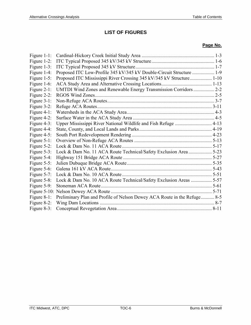
LIST OF FIGURES
Page No.
Figure 1-1: Cardinal-Hickory Creek Initial Study Area ........................................................... 1-3 Figure 1-2: ITC Typical Proposed 345 kV/345 kV Structure ................................................... 1-6 Figure 1-3: ITC Typical Proposed 345 kV Structure ................................................................ 1-7 Figure 1-4: Proposed ITC Low-Profile 345 kV/345 kV Double-Circuit Structure .................. 1-9 Figure 1-5: Proposed ITC Mississippi River Crossing 345 kV/345 kV Structure .................. 1-10 Figure 1-6: ACA Study Area and Alternative Crossing Locations ......................................... 1-13 Figure 2-1: UMTDI Wind Zones and Renewable Energy Transmission Corridors ................. 2-2 Figure 2-2: RGOS Wind Zones ................................................................................................. 2-5 Figure 3-1: Non-Refuge ACA Routes ....................................................................................... 3-7 Figure 3-2: Refuge ACA Routes ............................................................................................. 3-11 Figure 4-1: Watersheds in the ACA Study Area ....................................................................... 4-3 Figure 4-2: Surface Water in the ACA Study Area .................................................................. 4-5 Figure 4-3: Upper Mississippi River National Wildlife and Fish Refuge .............................. 4-13 Figure 4-4: State, County, and Local Lands and Parks ........................................................... 4-19 Figure 4-5: South Port Redevelopment Rendering ................................................................. 4-23 Figure 5-1: Overview of Non-Refuge ACA Routes ............................................................... 5-13 Figure 5-2: Lock & Dam No. 11 ACA Route ......................................................................... 5-17 Figure 5-3: Lock & Dam No. 11 ACA Route Technical/Safety Exclusion Area ................... 5-23 Figure 5-4: Highway 151 Bridge ACA Route ........................................................................ 5-27 Figure 5-5: Julien Dubuque Bridge ACA Route ..................................................................... 5-35 Figure 5-6: Galena 161 kV ACA Route .................................................................................. 5-43 Figure 5-7: Lock & Dam No. 10 ACA Route ......................................................................... 5-51 Figure 5-8: Lock & Dam No. 10 ACA Route Technical/Safety Exclusion Areas ................. 5-57 Figure 5-9: Stoneman ACA Route .......................................................................................... 5-61 Figure 5-10: Nelson Dewey ACA Route .................................................................................. 5-71 Figure 8-1: Preliminary Plan and Profile of Nelson Dewey ACA Route in the Refuge ........... 8-5 Figure 8-2: Wing Dam Locations ............................................................................................. 8-7 Figure 8-3: Conceptual Revegetation Area ............................................................................. 8-11

Alternative Crossings Analysis List of Abbreviations
ITC Midwest, ATC, DPC i Burns & McDonnell
LIST OF ABBREVIATIONS
Abbreviation Term/Phrase/Name
ACA Alternative Crossings Analysis
AMSL above mean sea level
APLIC Avian Powerline Interaction Committee
ATC American Transmission Company LLC and ATC Management Inc.
BGEPA Bald and Golden Eagle Protection Act
BMPs best management practices
CPP Clean Power Plan
CEQ Council on Environmental Quality
CFR Code of Federal Regulations
CPCN Certificate of Public Convenience and Necessity
CCP Comprehensive Conservation Plan
Dairyland Dairyland Power Cooperative
EA/FONSI Environmental Assessment/Finding of No Significant Impact
EA Environmental Assessment
EIS Environmental Impact Statement
EPA Environmental Protection Agency
ESA Endangered Species Act
FAA Federal Aviation Administration
FEMA Federal Emergency Management Agency
FONSI Finding of No Significant Impact
FWCA Fish and Wildlife Coordination Act

Alternative Crossings Analysis List of Abbreviations
ITC Midwest, ATC, DPC ii Burns & McDonnell
Abbreviation Term/Phrase/Name
GHG greenhouse gas
GIBA Globally Important Bird Area
GIS Geographic Information System
HDD horizontal directional drilling
HUC Hydrologic Unit Code
IAC Iowa Administrative Code
ICC Illinois Commerce Commission
IDNR Iowa Department of Natural Resources
IDOT Iowa Department of Transportation
INHF Iowa Natural Heritage Foundation
ITC Midwest ITC Midwest LLC
IUB Iowa Utilities Board
kV kilovolt
LWCF Land & Water Conservation Fund
MBTA Migratory Bird Treaty Act
MISO Midcontinent Independent System Operator Inc.
MTEP MISO Transmission Expansion Plan
MVPs Multi-Value Projects
MWh megawatt hour
MW megawatt
NEPA National Environmental Policy Act
NERC North American Electric Reliability Corporation

Alternative Crossings Analysis List of Abbreviations
ITC Midwest, ATC, DPC iii Burns & McDonnell
Abbreviation Term/Phrase/Name
NHD National Hydrography Dataset
NLCD National Land Cover Dataset
NRCS USDA Natural Resources Conservation Service (soil database)
NRHP National Register of Historic Places
NWI National Wetland Inventory
NWRS National Wildlife Refuge System
Tariff Open Access Transmission Tariff
PADUS Protected Areas Database of the U.S.
PSCW Public Service Commission of Wisconsin
RGOS Regional Generator Outlet Study
RPS Renewable Portfolio Standards
Refuge Upper Mississippi River National Wildlife and Fish Refuge
ROW right-of-way
RUS USDA Rural Utilities Service
SHPO State Historic Preservation Office
UMTDI Upper Midwest Transmission Development Initiative
USACE U.S. Army Corps of Engineers
USDA U.S. Department of Agriculture
USFWS U.S. Fish and Wildlife Service
USGS U.S. Geological Survey
WDNR Wisconsin Department of Natural Resources

Alternative Crossings Analysis List of Abbreviations
ITC Midwest, ATC, DPC iv Burns & McDonnell
(This page intentionally left blank)

Alternative Crossings Analysis Introduction
ITC Midwest, ATC, DPC 1-1 Burns & McDonnell
1.0 INTRODUCTION
ITC Midwest LLC (ITC Midwest), along with American Transmission Company LLC by its corporate
manager, ATC Management Inc., (together, ATC), and Dairyland Power Cooperative (Dairyland), a
cooperative organized under the laws of Wisconsin (all collectively, the Utilities), propose to construct
and own the Cardinal – Hickory Creek Transmission Line Project (Project), a 345 kilovolt (kV)
transmission line connecting northeast Iowa and southwest Wisconsin.
The Project requires crossing the Mississippi River. This Alternative Crossings Analysis (ACA) report
documents the Utilities’ investigation and assessment of potential Mississippi River crossing locations for
the Project and identifies the Utilities’ preferred alternative crossing location.
1.1 Project Description The Project proposal consists of a new transmission line and associated facilities in Iowa and Wisconsin.
The Project requires transmission system connection points at the existing Hickory Creek Substation
northwest of Dubuque, Iowa, a new intermediate substation near the Village of Montfort, Wisconsin, and
the existing Cardinal Substation near the Town of Middleton, Wisconsin (Figure 1-1). The Project has
been approved by the regional transmission organization, namely the Midcontinent Independent System
Operator Inc. (MISO). The Project, which has a 2023 in-service date, will be approximately 125 miles
long, depending on the final authorized route and the estimated costs are $500 million (2023 dollars). The
new 345 kV transmission line and associated facilities are proposed to meet interconnection requirements:
• A new 345 kV terminal within the existing Hickory Creek Substation in Dubuque County, Iowa
• A new intermediate substation near the Village of Montfort in Grant or Iowa County, Wisconsin,
to accommodate two new 345 kV line terminals
• A new 345 kV terminal for the existing Cardinal Substation in the Town of Middleton in Dane
County, Wisconsin
• A new 45- to 65-mile (depending on the final route) 345 kV transmission line between the
Hickory Creek Substation and the intermediate substation
• A new 45- to 60-mile (depending on the final route) 345 kV transmission line between the
intermediate substation and the existing Cardinal Substation
• A short, less than one mile, 69 kV line in Iowa to enable the removal of the 69 kV line that
crosses the Mississippi River at Cassville
• A rebuild of the Turkey River Substation with two 161/69 kV transformers, four 161 kV circuit
breakers, and three 69 kV circuit breakers

Alternative Crossings Analysis Introduction
ITC Midwest, ATC, DPC 1-2 Burns & McDonnell
(This page intentionally left blank)

! ! ! ! ! ! ! ! ! ! !!
!
!
!
!
!
!!
!
!
!
!
!
!!!!
! ! ! ! ! !! ! ! ! ! !!
!
!
!!
!! !
! ! ! ! ! ! ! ! ! ! ! ! ! ! ! ! ! !
!
!
!
!
!
!
!
!
!
!
!
!!
!
!
!
!
!
!
!
!
!
!
!
!
!
!
! !
!
!
! !
!
!
!!
!!
!
!!
! !!
! ! ! ! ! !
!
!!
!!
!
!!
!
!
!!
!!
!!
!
!
!
!
!!
! ! !
!! !
!!
!
!
!
!
!
! !! ! ! ! ! !
! ! ! ! !
!
!
!
!
!
!
!!
!
!!
! ! !!
! !
!
#*
#*
WISCONSIN
IOWA
ILLINOIS
Grant County
Iowa County
Dane County
Green CountyLafayette County
Clayton County
Dubuque County Jo Daviess CountyDelaware County
StephensonCounty
Crawford CountyAllamakee County
Sauk CountyRichland County
Jackson County
RockCounty
WinnebagoCounty
§̈¦94
£¤61
£¤151
£¤18
£¤14
£¤20
£¤52
£¤12
£¤51£¤78
£¤52
£¤151£¤61
£¤151
£¤18
£¤14
£¤18
£¤52
£¤20 £¤20
¬«39
¬«23
¬«11
¬«13
¬«3
¬«35¬«131
¬«92
¬«59
¬«76
¬«80
¬«130
¬«191
¬«69¬«F
¬«179
¬«128
¬«104
¬«364
¬«136
¬«138
¬«126
¬«113
¬«56 ¬«129
¬«176
¬«69
¬«11
¬«11
¬«60
¬«81
¬«39
¬«92
¬«80
¬«81¬«38
¬«19
¬«78
¬«130
¬«60
¬«133 ¬«81
¬«133
¬«78
¬«23
¬«81
¬«35
¬«59
¬«80
Madison
Fitchburg
Dubuque
Middleton
Steuben
Waunakee
Monroe
Wauzeka
Galena
Dyersville
Verona
Lena
Platteville
Oregon
Monona
Eastman
Prairie du Chien
Avoca
Asbury
Manchester
Dodgeville
Windsor
Freeport
Waukon
Lancaster
Potosi
Boscobel
Mineral Point
Mount Horeb
Farley PeostaDelhi
Guttenberg
Albany
Arena
Nora
Elkader
Brodhead
Luana
Menominee
Epworth
East Dubuque
Cobb
Lynxville
Muscoda
Belleville
Barneveld
Warren
Marquette
Fennimore
RidgewayMcGregor
Mazomanie
Highland
New Glarus
Brooklyn
Benton
Bagley
Cuba City
Monticello
Linden
Darlington
Hazel Green
Shullsburg
Spring GreenLone Rock
Garnavillo
Livingston
Cross Plains
Bloomington
Cassville
Browntown
Argyle
Delaware
Stockton
Gratiot
Edgewood Dickeyville
Davis
Ryan
Centralia
Blue River
Clayton
Apple River
Belmont
Sageville
Earlville
Hollandale
Rickardsville
Rewey
South Wayne
Montfort
Orangeville
Black Earth
Blue Mounds
Maple Bluff
Pecatonica
Winslow
Shorewood Hills
Greeley
Harpers FerryWaterville
Cedarville
Osterdock
Tennyson
Luxemburg
North Buena Vista
Dakota
New Vienna
Littleport
Hopkinton
St. Olaf
St. Donatus
Blanchardville
Garber
Patch GroveFarmersburg
Graf
Colesburg
Holy Cross
Woodman
Worthington
Bankston
Elizabeth Ridott
Scales Mound
Strawberry Point
Sherrill
Rock City
Millville
McFarland
Balltown
Durango
CO
PYR
IGH
T ©
201
6 B
UR
NS
& M
cDO
NN
ELL
EN
GIN
EER
ING
CO
MPA
NY,
INC
.
Source: Energy Velocity, NTAD, UGSG; IDNR; WDNR; ESRI, ATC, ITC Midwest, Burns & McDonnell
Path
: R:\I
TC\7
4417
_Hic
kory
_Crk
_Cas
svill
e\G
IS\D
ataF
iles\
ArcD
ocs\
AC
A_R
epor
t_Fi
gure
s\Fi
gure
1_1_
Car
dina
lHC
_Pro
ject
_Stu
dy_A
rea_
2016
0405
.mxd
ka
sam
uels
on
4/5/
2016
#* Substation
Cardinal-Hickory Creek Initial Study Area
Proposed IntermediateSubstation Siting Area
Existing 345 kV
Existing 161 kV! ! ! Existing 138 kV
Federal, State,and Local Lands
County
State
Municipal Area0 73.5
MilesNORTH
Figure 1-1Cardinal-Hickory Creek
Transmission Line ProjectCardinal-Hickory Creek Initial
Study Area
CardinalSubstation
Hickory CreekSubstation
IOWA
WISCONSIN
ILLINOIS
MINNESOTA
Locator Map

Alternative Crossings Analysis Introduction
ITC Midwest, ATC, DPC 1-4 Burns & McDonnell
(This page intentionally left blank)

Alternative Crossings Analysis Introduction
ITC Midwest, ATC, DPC 1-5 Burns & McDonnell
The connection between the Hickory Creek Substation and the intermediate substation requires a crossing
of the Mississippi River at a location that includes the U.S. Fish and Wildlife Service (USFWS)-managed
Upper Mississippi National Wildlife and Fish Refuge (Refuge), the longest linear refuge in the United
States. The Refuge extends north to south through Minnesota, Wisconsin, Iowa, and Illinois for
approximately 260 river miles (USFWS, 2006).
For the Mississippi River crossing portion of the Project (and depending on the selected crossing
location), the Utilities are presenting a 345 kV/345 kV design, but would operate the lines at 345 kV/161
kV until system conditions warranted operating the facility at 345 kV/345 kV (Figure 1-2). While the
current needs are for a 345 kV line and a 161 kV line, the increase in voltage capability of the second
circuit is a prudent and cost-effective investment to accommodate additional transmission facilities in a
manner that would avoid future impacts to the Refuge if another 345 kV transmission line between Iowa
and Wisconsin were needed. Additional information regarding a potential 345 kV/161 kV design through
the Refuge is provided in Appendix G.
Depending on the alternative crossing location ultimately selected for this Project, the 345 kV line would
be approximately 125 miles long. The typical right-of-way (ROW) width for the Project would be 200
feet in Iowa and 150 feet in Wisconsin. In addition, unique ROW widths have been developed in certain
areas to mitigate potential impacts to sensitive resources, such as avian species at the Refuge crossing
locations. For most of the remainder of the ACA Study Area, the Utilities propose to utilize single-pole
structures that would have a typical height of 150 feet. A diagram of a typical 345 kV structure utilized
for the ACA Study Area is shown in Figure 1-3. The structures would support the new 345 kV high-
voltage transmission line with three current-carrying phases made up of aluminum conductors in addition
to two overhead shield wires for the purpose of lightning protection and protective relay communications.
Depending on final route, the new 345 kV line may be co-located with existing transmission lines.
Typical spans of the transmission line structures would range from 500 to 1,100 feet.

Alternative Crossings Analysis Introduction
ITC Midwest, ATC, DPC 1-6 Burns & McDonnell
Figure 1-2: ITC Typical Proposed 345 kV/345 kV Structure

Alternative Crossings Analysis Introduction
ITC Midwest, ATC, DPC 1-7 Burns & McDonnell
Figure 1-3: ITC Typical Proposed 345 kV Structure

Alternative Crossings Analysis Introduction
ITC Midwest, ATC, DPC 1-8 Burns & McDonnell
Additionally, there may be locations along the route that utilize different structure designs and/or ROW
for purposes of reducing potential impacts. For the portion of the ACA route within the Refuge, a
preliminary low-profile structure is proposed with a design height of approximately 75 feet to reduce the
likelihood of avian collisions. The low-profile structure height for the design presented for the Nelson
Dewey ACA route would also be at or below the height of the mature woodlands on the north side of Oak
Road. This lower, wider profile would require a 260-foot-wide ROW. The structures would be horizontal-
symmetrical H-frame structures on concrete foundations with a typical span length of approximately 500
feet and would consist primarily of tubular steel H-frame structures (Figure 1-4). The crossing structures
on the banks of the Mississippi River, shown in Figure 1-5, would also consist primarily of tubular steel
H-frame structures and would be constructed to an approximate height of 198 feet (includes foundation
reveal; the general sketch shown on Figure 1-5 includes the just the length of steel at 195 feet).
The crossing structure height would account for the required distance above the navigable river channel,
as defined by U.S. Coast Guard requirements.
1.2 Owners Three separate entities would own the Project. ITC Midwest owns the existing Hickory Creek Substation.
ITC Midwest and Dairyland would jointly own the 345 kV transmission line facilities in Iowa and a
portion of the line in Wisconsin, approximately from the Iowa-Wisconsin state border to the intermediate
substation.10 ATC would own the new intermediate substation and owns the Cardinal Substation. ATC
and Dairyland would jointly own the 345 kV transmission line facilities from approximately the
intermediate substation to the Cardinal Substation. The Utilities are transmission-owning members of
MISO.
ITC Midwest is a wholly-owned subsidiary of ITC Holdings Corp., the nation’s largest independent
electric transmission company. ITC Midwest connects more than 700 communities with approximately
6,600 circuit miles of transmission line over roughly 54,000 square miles in Iowa, southern Minnesota,
northeastern Missouri, and northwestern Illinois. ITC Midwest is headquartered in Cedar Rapids, Iowa,
and maintains operating locations at Dubuque, Iowa City, and Perry, Iowa, and Albert Lea and Lakefield,
Minnesota. ITC Midwest has also received a Certificate of Authority to operate as a public utility in
Wisconsin.
10 The Project owners will identify the final ownership point once construction is complete based on the final costs of the Project.

Alternative Crossings Analysis Introduction
ITC Midwest, ATC, DPC 1-9 Burns & McDonnell
Figure 1-4: Proposed ITC Low-Profile 345 kV/345 kV Double-Circuit Structure

Alternative Crossings Analysis Introduction
ITC Midwest, ATC, DPC 1-10 Burns & McDonnell
Figure 1-5: Proposed ITC Mississippi River Crossing 345 kV/345 kV Structure

Alternative Crossings Analysis Introduction
ITC Midwest, ATC, DPC 1-11 Burns & McDonnell
ATC began operations in 2001 as the nation's first multi-state, transmission-only utility. ATC owns and
operates more than 9,500 miles of high-voltage transmission lines and 530 substations in portions of
Wisconsin, Michigan, Minnesota, and Illinois. Since its formation, ATC has upgraded or built more than
2,300 miles of transmission lines and 175 substations. ATC is headquartered in Pewaukee, Wisconsin,
and has offices in Madison, Cottage Grove, and De Pere, Wisconsin, and Kingsford, Michigan.
Dairyland is a not-for-profit generation and transmission cooperative headquartered in La Crosse,
Wisconsin. Dairyland is owned by and provides the wholesale power requirements for 25 separate
distribution cooperatives in southern Minnesota, western Wisconsin, northern Iowa, and northern Illinois
and 15 municipal utilities in Wisconsin, Minnesota, and Iowa. Dairyland serves a population of
approximately 600,000. Dairyland owns or has under contract generating units totaling approximately
1,236 megawatts (MW) and owns approximately 3,200 miles of transmission lines ranging from 34.5 to
161 kV.
1.3 Development of Cardinal-Hickory Creek Initial Study Area and Alternative Crossing Locations A total of seven alternative crossings locations within the Cardinal – Hickory Creek Initial Study Area
were identified for review and analysis in this ACA (Figure 1-6). The siting of these seven potential
crossing locations is directly related to the MISO-approved project configuration for the Cardinal-Hickory
Creek Project. As further discussed in Chapter 3.0, MISO’s project configuration includes a Project
terminus (substation) at the Hickory Creek Substation in Dubuque County, Iowa, and the Cardinal
Substation in Dane County, Wisconsin; as well as an eventual route across the Mississippi River for a
new 345 kV line that would connect these two points.
Given that the location of the Mississippi River crossing would determine the potential routes in Iowa and
Wisconsin, the Utilities first identified a Mississippi River crossing study area (ACA Study Area) that
would both (i) meet the Project purpose and need and (ii) include existing crossing locations consistent
with the intended Project configuration. Defining northern and southern boundaries for the Cardinal-
Hickory Creek Initial Study Area and the ACA Study Area is discussed in greater detail in Section 3.1.

Alternative Crossings Analysis Introduction
ITC Midwest, ATC, DPC 1-12 Burns & McDonnell
(This page intentionally left blank)

! !! ! ! ! ! ! ! ! ! ! ! ! ! ! ! ! !
!
!
!
!
!
!
!
!
!
!
!
!!
!
!
!
!
!!
!
!
!
!!!!!! ! ! ! !
!
!
!
!
!
!
!
!
!
!
!
#*
_̂
_̂_̂
_̂
_̂_̂_̂
Highway 151 Bridge
Galena 161 kV
Julien DubuqueBridge
GrantCounty
DubuqueCounty
ClaytonCounty
DelawareCounty
Jo DaviessCounty
Jackson County
¬«133
¬«81
¬«35
¬«136
¬«3
¬«129
¬«11¬«136
¬«136
¬«81
£¤61
£¤52
£¤20
£¤151
£¤61
£¤52
£¤52
£¤61
£¤151
Dubuque
Dyersville
Asbury
Lancaster
Potosi
FarleyPeosta
Guttenberg
Epworth
EastDubuque
Cassville
Dickeyville
Centralia
Sageville
Bloomington
Rickardsville
Bagley
Tennyson
Luxemburg
North Buena Vista
New Vienna
Graf
Clayton
Holy Cross
Worthington
Bankston
Osterdock
Sherrill
Millville
Balltown
Durango L&D 11
Stoneman
L&D 10
NelsonDewey
CO
PYR
IGH
T ©
201
6 B
UR
NS
& M
cDO
NN
ELL
EN
GIN
EER
ING
CO
MPA
NY,
INC
.
Source: Energy Velocity, NTAD, UGSG; ESRI, ATC, ITC Midwest, Burns & McDonnell
Path
: R:\I
TC\7
4417
_Hic
kory
_Crk
_Cas
svill
e\G
IS\D
ataF
iles\
ArcD
ocs\
AC
A_R
epor
t_Fi
gure
s\Fi
gure
1_6_
ACA_
Ana
lysi
sAre
a_20
1604
05.m
xd
kasa
mue
lson
4/
5/20
16
#* Substation
ACA Study AreaCardinal-Hickory CreekInitial Study Area
_̂ Alternative Crossing Location
Existing 345 kV
Existing 161 kV
! ! Existing 138 kV
County
MunicipalArea
State
0 42
Miles
NORTH
Figure 1-6Cardinal-Hickory Creek
Transmission Line ProjectACA Study Area and
Alternative Crossing LocationsIssued 4/5/2016
Hickory CreekSubstation
IOWAWISCONSIN
ILLINOIS
Locator Map

Alternative Crossings Analysis Introduction
ITC Midwest, ATC, DPC 1-14 Burns & McDonnell
(This page intentionally left blank)

Alternative Crossings Analysis Introduction
ITC Midwest, ATC, DPC 1-15 Burns & McDonnell
After the northern and southern study area boundaries were set, the Utilities then investigated the
alternative crossing locations of the Mississippi River and Refuge that included existing linear
infrastructure, as described in Section 3.1. Locating the Project near existing linear infrastructure would
reduce the need for new corridors across public and/or private ROWs and potentially reduce impacts to
sensitive resources within the ACA Study Area. Through this investigation, the Utilities identified the
seven alternative crossing locations of the Mississippi River and Refuge. Four alternative crossing
locations are outside of the Refuge and three are within the Refuge boundaries.11 The Utilities then
evaluated those seven alternative crossings, which are listed as follows (from north to south):
1. Lock and Dam No. 10 in Guttenberg, Iowa (L&D 10)
2. Turkey River to the Nelson Dewey Power Plant crossing in Cassville, Wisconsin (Nelson Dewey)
3. Millville to Stoneman 69 kV transmission line and Turkey River to Stoneman 161 kV line
crossing (co-located) in Cassville, Wisconsin (Stoneman)
4. Lock and Dam No. 11 in Dubuque, Iowa (L&D 11)
5. Highway 61/151 crossing in Dubuque, Iowa (Highway 151 Bridge)
6. Dubuque to Galena 161 kV line crossing in Dubuque, Iowa (Galena 161 kV Line)
7. Julien Dubuque Bridge/Highway 20 crossing in Dubuque, Iowa (Julien Dubuque Bridge)
The Utilities’ detailed analysis of each of these crossings is described in Chapters 4.0 and 5.0.
1.4 Overview of Agency Requirements and Outreach The analyses contained in this ACA report are intended to provide agency decision-makers with
information and analyses of the potential constraints and opportunities associated with each of the seven
ACA routes and alternative crossing locations within the ACA Study Area. In addition, this report
identifies the known permits/approvals required to utilize these alternative crossing locations (see Chapter
6.0), and the effect of these requirements on the potential feasibility of a given alternative crossing
location. This report also identifies agency and outreach efforts associated with this Project (Chapter 7.0).
11 The L&D No. 10 crossing location (Guttenberg, Iowa) includes lands managed and operated under a 2001 cooperative agreement between the U.S. Army Corps of Engineers and the USFWS (USFWS 2006). Although there is a “break” in the Refuge where Lock and Dam No. 10 crosses the Mississippi River, this “break” relates specifically to the management and operation of the lock and dam facility and does not include a gap in the overall Refuge boundaries at this location (as compared to the gap in the Refuge at Dubuque, Iowa). As a result, Utilities classified the L&D No. 10 alternative crossing location as a Refuge crossing alternative.

Alternative Crossings Analysis Introduction
ITC Midwest, ATC, DPC 1-16 Burns & McDonnell
1.5 Organization of This Report This ACA is organized into the following ten chapters.
Executive Summary
Chapter 1.0: Introduction
Chapter 2.0: Purpose and Need
Chapter 3.0: Development of Cardinal-Hickory Creek Initial Study Area, Alternative Crossing Locations, and ACA Study Area
Chapter 4.0: Description of the ACA Study Area and Alternative Crossing Locations
Chapter 5.0: Analysis of ACA Routes and Alternative Crossing Locations
Chapter 6.0: Major Federal, State, and Local Permits and Approvals
Chapter 7.0: Agency Outreach
Chapter 8.0: Preferred Crossing Location for the Project
Chapter 9.0: References
Appendices of supporting documents are also provided.
Appendix A: Alternative Analysis Data
Appendix B: Agency Meeting Minutes and Other Materials
Appendix C: City of Dubuque Resolution and Materials
Appendix D: Evaluation of Underground Transmission Installation
Appendix E: MVP Triennial Review
Appendix F: State Protected Species
Appendix G: Optional Transmission Design through the Refuge
Appendix H: National Wildlife Refuge System Improvement Act of 1997

Alternative Crossings Analysis Purpose and Need
ITC Midwest, ATC, DPC 2-1 Burns & McDonnell
2.0 PURPOSE AND NEED
Multiple study efforts beginning in 2008 and culminating in 2011 identified the Project as a necessary
facility to ensure a reliable and efficient electric grid that keeps pace with energy and policy demands.
Specifically, in its 2011 MISO Transmission Expansion Plan (MTEP), MISO12 designated a portfolio of
17 Multi-Value Projects (MVPs) designed to create a backbone system to reliably and cost-effectively
deliver renewable energy, primarily from high wind resource areas in the west and Midwest, to
population centers to the east. This portfolio included the Project.
The Project would address multiple needs on the regional transmission system. First, it would address
reliability issues on the regional bulk transmission system; second, it would cost-effectively increase
transfer capacity to enable additional renewable generation needed to meet state renewable portfolio
standards (RPS) and support the nation’s changing energy mix; third, it would alleviate congestion on the
transmission grid to reduce the overall cost of delivering energy; and fourth, it responds to public policy
objectives aimed at enhancing the nation’s transmission system and reducing carbon dioxide emissions.
The following sections describe previous study efforts supporting the Project, MISO’s designation of the
MVP Portfolio, and the overall purpose and need for the Project.
2.1 Study Efforts Supporting the Project The need for additional capacity on the transmission system serving Midwest states to reliably and cost-
effectively integrate renewable wind generation has been under study for more than a decade. As
discussed in this and the next section, study efforts aimed at identifying solutions to address this need
have focused on how to move wind-generated energy from high wind areas in Iowa, Minnesota, South
Dakota, and North Dakota to load centers throughout the MISO footprint. As states have enacted
Renewable Portfolio Standards (RPS) and the country shifts its energy mix to reduce carbon emissions,
the need for additional renewable energy, and the ability to transfer this energy, has increased and is
forecasted to continue to rise.
12 MISO is a non-profit regional transmission organization responsible for the independent planning and operation of the transmission grid and wholesale energy market across 15 states and the province of Manitoba. See MISO, https://www.misoenergy.org/Pages/Home.aspx. MISO oversees and coordinates regional transmission planning and regional transmission services and manages access to the transmission grid to facilitate fair and competitive wholesale electric markets. MISO became the first regional transmission organization to be approved by the Federal Energy Regulatory Commission (FERC) in 2001, and operates under a FERC-approved open-access transmission tariff.
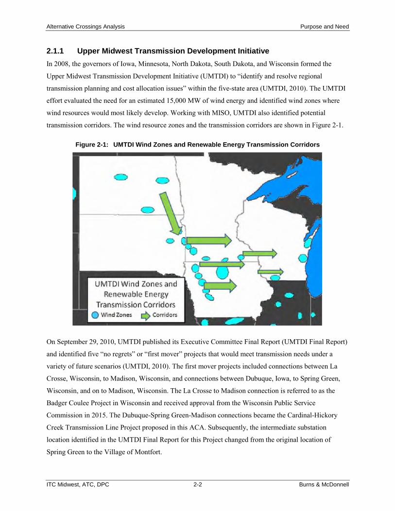
Alternative Crossings Analysis Purpose and Need
ITC Midwest, ATC, DPC 2-2 Burns & McDonnell
2.1.1 Upper Midwest Transmission Development Initiative In 2008, the governors of Iowa, Minnesota, North Dakota, South Dakota, and Wisconsin formed the
Upper Midwest Transmission Development Initiative (UMTDI) to “identify and resolve regional
transmission planning and cost allocation issues” within the five-state area (UMTDI, 2010). The UMTDI
effort evaluated the need for an estimated 15,000 MW of wind energy and identified wind zones where
wind resources would most likely develop. Working with MISO, UMTDI also identified potential
transmission corridors. The wind resource zones and the transmission corridors are shown in Figure 2-1.
Figure 2-1: UMTDI Wind Zones and Renewable Energy Transmission Corridors
On September 29, 2010, UMTDI published its Executive Committee Final Report (UMTDI Final Report)
and identified five “no regrets” or “first mover” projects that would meet transmission needs under a
variety of future scenarios (UMTDI, 2010). The first mover projects included connections between La
Crosse, Wisconsin, to Madison, Wisconsin, and connections between Dubuque, Iowa, to Spring Green,
Wisconsin, and on to Madison, Wisconsin. The La Crosse to Madison connection is referred to as the
Badger Coulee Project in Wisconsin and received approval from the Wisconsin Public Service
Commission in 2015. The Dubuque-Spring Green-Madison connections became the Cardinal-Hickory
Creek Transmission Line Project proposed in this ACA. Subsequently, the intermediate substation
location identified in the UMTDI Final Report for this Project changed from the original location of
Spring Green to the Village of Montfort.

Alternative Crossings Analysis Purpose and Need
ITC Midwest, ATC, DPC 2-3 Burns & McDonnell
2.1.2 MISO Regional Generator Outlet Study Also beginning in 2008, MISO, in conjunction with state utility regulators and industry stakeholders,
initiated the Regional Generator Outlet Study (RGOS), a collaborative, multi-year effort to determine
how to build the transmission facilities that would meet the significant renewable energy requirements
within MISO at the lowest delivered per megawatt hour (MWh) cost (MISO, 2010).
Since its inception, MISO has conducted studies of the transmission system within the MISO footprint to
identify and recommend construction of projects required to address network reliability issues. Pursuant
to the directives in Federal Energy Regulatory Commission Order Nos. 890 and 1000, MISO’s
transmission planning process has broadened to identify and recommend those projects that increase
system efficiency and reduce costs, as well as those projects that meet specific state and federal public
policy objectives (Rauch Direct Testimony, 2014: 12r:5-10). MISO’s planning process evaluates
transmission system congestion that may limit access to the most efficient energy resources, and analyzes
potential improvements that could be implemented to meet forecasted energy requirements (Rauch Direct
Testimony, 2014: 13r:19-21). MISO reports on its recommended transmission projects in its annual
MTEP.
MISO uses a “bottom up, top down” approach in its transmission expansion planning process (Rauch
Direct Testimony, 2014: 13r:8). In this approach, MISO first relies on individual transmission owners to
identify and report the projects that they have determined are needed for their systems (Rauch Direct
Testimony, 2014: 13r:9-11). MISO then reviews the various projects in relation to one another, and the
MISO system as a whole, to prioritize projects based on their ability to effectively address system
reliability, reduce consumer costs, and address evolving federal and state energy policy issues (Rauch
Direct Testimony, 2014: 13r:12-18).
In the RGOS effort, with input from the state regulators, planning engineers first identified areas where
wind generation would likely be sited in “wind zones” (Rauch Direct Testimony, 2014: 18r:7-12). RGOS
then evaluated three transmission expansion scenarios to reliably integrate wind energy from the zones.
The first was a “native” voltage overlay that does not introduce new voltages, such as 765 kV, in areas
where they do not already exist. The second set was a 765 kV overlay throughout the study footprint. The
third set was a native transmission overlay with the addition of direct current transmission (MISO, 2010).
Consistent with the UMTDI recommendations, the RGOS set of 18 candidate projects included 345 kV
lines between North La Crosse and Madison and between Dubuque and Madison (MISO, 2010). RGOS
concluded: “The development of these corridors will provide for the continuation and extension of the

Alternative Crossings Analysis Purpose and Need
ITC Midwest, ATC, DPC 2-4 Burns & McDonnell
west to east transmission path to provide more areas with greater access to the high wind areas within the
Buffalo Ridge and beyond” (MISO, 2010).
2.2 MISO MVP Portfolio Development Approximately 11 months of intensive studies were performed on the candidate RGOS portfolio, with
intense review and involvement by stakeholders, including the MISO states. MISO then selected projects
for further evaluation that were common to all three RGOS scenarios and where previous reliability,
economic, and generation interconnection analyses had been performed (MISO, 2010). MISO developed
the final MVP Portfolio based on the following criteria taken from Attachment FF of MISO’s Open
Access Transmission Tariff (Tariff):
• Criterion 1: The MVP must enable the transmission system to deliver energy reliably and
economically in support of documented federal or state energy policy mandates or laws.
• Criterion 2: The MVP must provide multiple types of economic value across multiple pricing
zones with a total cost/benefit ratio prescribed in Attachment FF of the Tariff.
• Criterion 3: The MVP must address at least one transmission issue associated with a projected
violation of a North American Electric Reliability Corporation (NERC) or Regional Entity
standard and at least one economic-based transmission issue that provides economic value across
multiple pricing zones (MISO, 2012).
As stated in the MTEP 11, the resulting 17-project MVP Portfolio:
…combines reliability, economic and public policy drivers to provide a transmission solution that provides benefits in excess of its costs throughout the MISO footprint. This portfolio, when integrated into the existing and planned transmission network, resolves about 650 reliability violations for more than 6,700 system conditions, enabling the delivery of 41 million MWh of renewable energy annually to load. The portfolio also provides strong economic benefits; all zones within the MISO footprint see benefits of at least 1.6 to 2.8 times their cost (MISO, 2011).
Importantly, the MVP Portfolio creates a transmission network that is able to respond to evolving
reliability and generation needs within the MISO footprint (MISO, 2011). As a result, the MVP Portfolio
of projects will be able to support a variety of different generation fuel sources that support a variety of
generation policies (MISO, 2011). A map showing the RGOS wind zones and the candidate MVP
Portfolio of projects is shown in Figure 2-2.

Alternative Crossings Analysis Purpose and Need
ITC Midwest, ATC, DPC 2-5 Burns & McDonnell
Figure 2-2: RGOS Wind Zones
In 2011, MISO determined that the projects in the MVP Portfolio would reduce congestion, improve
competition in wholesale markets, spread the benefits of low-cost generation, and enable the reliable
delivery of renewable energy pursuant to states’ RPS (Rauch Direct Testimony, 2014: 17r:13-17, 20r:17-
20 & 33r:1-3). In addition, MISO found that the MVP Portfolio: (1) “enhances generation flexibility,” (2)
“creates a more robust regional transmission system that decreases the likelihood of future blackouts,” (3)
“increases the geographic diversity of wind resources that can be delivered, increasing the average wind
output available at any given time,” (4) “supports the creation of thousands of local jobs and billions in
local investment,” and (5) “reduces carbon emissions by 9 to 15 million tons annually” (MISO, 2014b).
Also, in 2011, MISO determined that the MVP Portfolio of projects had a benefit-to-cost ratio ranging
from 1.8 to 3.0 (MISO, 2014b). These economic benefits include (1) enabling low-cost generation to
displace higher-cost generation; (2) allowing more efficient dispatch of operating reserves; (3) reducing
transmission line losses; (4) reducing future planning reserve margin requirements; and (5) avoiding costs
for reliability projects that would otherwise need to be constructed.

Alternative Crossings Analysis Purpose and Need
ITC Midwest, ATC, DPC 2-6 Burns & McDonnell
Simultaneous to these three processes (UMTDI, RGOS, and MVP Portfolio) that culminated in the
identification of 17 MVP projects, MISO and the states within MISO convened two separate proceedings
over 18 months to address who would pay for the MVPs. Because the portfolio of MVPs benefited every
zone in MISO, most agreed that the costs for each MVP should be shared by all. So, regardless of where
the MVP would be located, every utility in MISO would pay a pro rata share for that project based on
that utility’s wholesale consumption of electric energy within MISO.13 This agreement was premised on
building all of the 17 projects so that every state shared in the benefits of the portfolio.
2.2.1 Transmission System Reliability The electric transmission system in the United States is comprised of a highly decentralized
interconnected network of generating plants, high-voltage transmission lines, and distribution facilities. In
many areas of the Midwest, the transmission backbone system is comprised of 345 kV lines. This Project
would add a 345 kV connection between Iowa and Wisconsin that would improve the reliability of the
regional transmission system, particularly in southern Wisconsin where there is a lack of connectivity to
the regional 345 kV network. MISO’s studies also found that construction of this Project would also
reduce the need for other lower voltage transmission line upgrades in Wisconsin and Iowa that would be
needed, absent this Project, to provide future reliability of the transmission system.
2.2.2 Increased Economic Benefits The addition of a 345 kV transmission line between Iowa and Wisconsin would provide a path for lower
cost renewable energy to reach market, reducing overall energy costs. In 2014, MISO conducted its tariff-
required MVP Triennial Review (MISO, 2014b). The MVP Triennial Review provided updated insight
into the MVP Portfolio’s anticipated benefits relating to economics, reliability, public policy, and
qualitative and social benefits (see Section 2.2.3, below for more information on these benefits) (MISO,
2014b). Based on the MVP Triennial Review analysis, the collective MVP Portfolio is now estimated to
provide a benefit-to-cost ratio ranging from 2.6 to 3.9 and result in $13.1 billion to $49.6 billion of net
benefits over the next 20 to 40 years across the MISO footprint (MISO, 2014b).
The MVP Portfolio’s economic benefits analysis is contained in the MVP Triennial Review attached as
Appendix E.
13 Ill. Commerce Comm’n v. Federal Energy Regulatory Commission, No. 11-3421, slip op. at 7 (7th Cir. June 7, 2013).

Alternative Crossings Analysis Purpose and Need
ITC Midwest, ATC, DPC 2-7 Burns & McDonnell
2.2.3 Increased Transfer Capability – Reliable Renewable Energy Integration At the time of the MTEP 11 analysis, all but one of 12 MISO states had enacted RPS mandates or goals.
These mandates are state specific, but generally started in 2010 and increase with increases in energy
usage. The MTEP 11 report recognized that the RPS created “a great deal of uncertainty about how these
goals will be achieved, including the location of future generation and the required transmission to enable
renewable integration” (MISO, 2011). However, MISO recognized that compliance will likely focus on
capturing the abundant wind resources present throughout the MISO footprint.
The Project creates a tie between the 345 kV network in east-central Iowa and the 345 kV network in
south-central Wisconsin. This tie between these two 345 kV networks creates an additional wind outlet
path that brings power from wind rich areas in the Midwest to the MISO footprint. The Utilities estimate
that the incremental increase in transfer capability created by the Project will be most significant during
summer peak load when electricity demand is at its highest, and during the “shoulder months”—spring
and fall—when wind generation is generally at its highest.
The collective MVP Portfolio will significantly increase transfer capability across the MISO footprint.
The entire MVP Portfolio will enable delivery of 41 million MWh of wind energy. In contrast, if the
MVP Portfolio were not constructed, MISO estimates that in 2023, up to 10,500 MW of potential wind
generation energy would be curtailed (MISO, 2014b).
In the Triennial Review, MISO confirmed that the MVP Portfolio will support RPS. The MVP Portfolio
enables 4,300 MW of wind generation beyond the amount needed to meet 2028 RPS requirements and
mandates and does so in a more reliable and economic manner than without the associated transmission
upgrades (MISO, 2014b).
2.2.4 National Public Policy Benefits Access to renewable energy generation has become increasingly important as states have adopted RPS
and that is one of the reasons why the MVP Portfolio was created. MISO determined in 2011 that this
Project was needed for conveying wind energy. If anything, that need has increased since 2011 due to
federal actions including policy directives to reduce carbon emissions. The MVP Portfolio, including the
Project, will also support these other public policy objectives.
2.2.4.1 Presidential Directives The Obama Administration has developed a wide range of initiatives that seek to reduce GHG emissions
through policies that support increased renewable energy generation. In June 2013, President Obama
announced the Climate Action Plan, a national plan for tackling climate change (Executive Office of the

Alternative Crossings Analysis Purpose and Need
ITC Midwest, ATC, DPC 2-8 Burns & McDonnell
President, 2013). The plan, which is divided into three key pillars, outlines steps to cut carbon emissions
in the United States. The three key pillars are: (1) cutting carbon emissions in the United States; (2)
preparing the country for the impacts of climate change; and (3) leading international efforts to address
global climate change. As part of the first pillar, the President’s Climate Action Plan directed the EPA to
establish the first ever restrictions on carbon emissions from power plants, the largest source of
unregulated carbon emissions in the United States.14 Also, the President’s Climate Action Plan fast-tracks
permitting for renewable energy projects on public lands; focuses on streamlining the siting, permitting,
and review process for all transmission projects; increases funding for clean energy technology and
efficiency improvements; and seeks to improve efficiency standards for buildings and appliances, as well
as heavy trucks.
One of the mechanisms that the Obama Administration has used to encourage greater use of renewable
energy is to streamline the federal permitting process for infrastructure, such as high-voltage transmission
projects, which are necessary to deliver utility-scale renewable energy.15 On June 7, 2013, President
Obama signed a Presidential Memorandum entitled Transforming our Nation’s Electric Grid Through
Improved Siting, Permitting, and Review that recognized the importance of investing in transmission
infrastructure to meet the nation’s energy needs:
Our Nation's electric transmission grid is the backbone of our economy, a key factor in future economic growth, and a critical component of our energy security. Countries that harness the power of clean, renewable energy will be best positioned to thrive in the global economy while protecting the environment and increasing prosperity. In order to ensure the growth of America’s clean energy economy and improve energy security, we must modernize and expand our electric transmission grid (Obama, 2013b).
The memorandum put forth initiatives to expedite the review of transmission projects on federal lands, to
help develop principles for establishing energy corridors and encourage the use of such, and to improve
the overall transmission siting, permitting, and review processes.
14 The EPA published its final rule on October 23, 2015 which is discussed in greater detail in Section 2.2.4.3. 15 See the President’s May 17, 2013 memorandum, Modernizing Federal Infrastructure Review and Permitting Regulations, Policies and Procedures, which recognized that “[r]eliable, safe, and resilient infrastructure is the backbone of an economy built to last. Investing in our Nation’s infrastructure serves as an engine for job creation and economic growth, while bringing immediate and long-term economic benefits to communities across the country” Id. (Obama, 2013a). The memorandum further states that “[t]he quality of our infrastructure is critical to maintaining our Nation's competitive edge in a global economy and to securing our path to energy independence.” Id.

Alternative Crossings Analysis Purpose and Need
ITC Midwest, ATC, DPC 2-9 Burns & McDonnell
2.2.4.2 Department of Interior Secretarial Orders, e.g., Nos. 3285 and 3289 In 2009, the Department of Interior Secretary created the Task Force on Energy and Climate Change.
That Task Force was charged with “prioritizing the permitting and appropriate environmental review of
transmission ROW applications that are necessary to deliver renewable energy generation to
consumers.”16 The Task Force was also charged with developing best management practices (BMPs) for
transmission projects on public lands to “ensure the most environmentally responsible development and
delivery of renewable energy” (Secretary of the Interior, 2009).
Four years later, the Department of Interior issued another Secretarial Order acknowledging that the
Department needs to manage federal lands “to promote environmentally responsible renewable energy
development” (Secretary of the Interior, 2013). The Order further identified that in light of the “dramatic
effects of climate change” on the nation, “the Department must change the way it manages resources for
which it is the steward” (Secretary of the Interior, 2013). To achieve this, the Order directed its Climate
Change Task Force to identify ways in which the Department’s existing mitigation policies and practices
can be “harmonize[d]…to minimize any redundancy and maximize efficiency in the review and
permitting process” (Secretary of the Interior, 2013).
2.2.4.3 Environmental Protection Agency Demonstrating the importance of wind generation in MISO, the U.S. EPA recently estimated that an
additional 24,000 to 26,000 MW of wind would need to be built nationwide between now and 2025 to
allow the states to comply with an interim target within the EPA’s CPP (EPA, 2015a, 2015b). As of the
writing of this ACA, numerous parties—including the State of Wisconsin—have sued the EPA in the
U.S. Court of Appeals for the District of Columbia Circuit and south to vacate the rule.17 On February 9,
2016, the U.S. Supreme Court issued a stay of the CPP until the legal challenges are resolved.18 While it
is uncertain whether the CPP will be upheld by the courts, given the long lead time for transmission
infrastructure it is important to examine how the rule could impact the need for additional transmission
facilities.
16 Also in 2009, nine participating federal agencies entered into a Memorandum of Understanding Regarding Coordination in Federal Agency Review of Electric Transmission Facilities on Federal Land (2009 MOU) to expedite the siting of new high voltage transmission facilities that cross federal lands by establishing roles and responsibilities for agencies and in improving coordination among the agencies in reviewing and granting authorizations for projects. The 2009 MOU is available at: https://www.whitehouse.gov/files/documents/ceq/ Transmission%20Siting%20on%20Federal%20Lands%20MOU.pdf. 17 See Opening Brief of Petitioners on Core Legal Issues at 6, West Virginia v. EPA, No. 15-1363 (D.D.C. Feb. 19, 2016). 18 Order in Pending Case, West Virginia v. EPA, No.15A773, (U.S. Feb. 9, 2016).

Alternative Crossings Analysis Purpose and Need
ITC Midwest, ATC, DPC 2-10 Burns & McDonnell
The EPA developed the CPP to address carbon dioxide emissions from existing coal- and gas-fired power
plants. The EPA issued a proposed rule in June 2014, and on October 23, 2015 published its final rule.
The final rule requires states to meet state-specific carbon emissions reduction goals; however, it provides
states flexibility in determining how to achieve CPP compliance (Federal Register, 2015). Under the final
rule, states must submit a plan (“state plan” or “state implementation plan”) by 2018, begin reducing
carbon dioxide emissions by 2022, and continue emission reductions through 2030 (Federal Register,
2015).
To meet the carbon dioxide emission reduction goals set forth in the CPP, it is anticipated that additional
transmission infrastructure will be required. Based on the June 2014 draft rule, NERC conducted a multi-
phase reliability study focused on identifying potential reliability and resource adequacy concerns
resulting from implementation of the draft CPP and confirmed the need for additional infrastructure. At
the time of preparation of this document, NERC has not yet released its analysis of the EPA’s final CPP
rule. As to the draft CPP, NERC identified two main areas of potential reliability concerns: “(1) direct
impacts to resource adequacy and electric infrastructure, and (2) impacts resulting from the changing
resource mix that occur as a result of replacing retiring generation, accommodating operating
characteristics of new generation, integrating new technologies, and imposing greater uncertainty in
demand forecasts” (NERC, 2014). NERC concluded that more transmission resources would be required
to deliver new generation resources to points of consumption (NERC, 2014). One of the necessary lines
NERC identified was an additional 345 kV transmission line between Iowa and Wisconsin.
MISO also analyzed the draft CPP and identified significant coal generation retirements, which would
require substantial transmission system investments. MISO is in the process of completing a four-phase
analysis of potential impacts of the draft and final CPP on the MISO system. Phases I to III of the study
have been completed and were based on the draft rule; Phase IV will reflect the impacts of the final rule.
Phases I and II, which focused on the economic analyses of compliance costs, indicated that the most
cost-effective compliance with the draft CPP would likely lead to 14,000 MW of coal generation
retirements (MISO, 2014b). The Phase III study concluded that a multi-billion dollar transmission build-
out would be needed to comply with the CPP scenarios studied (MISO, 2015b). MISO recently completed
their Mid-Term Analysis of EPA’s Final Clean Power Plan and concluded that more transmission
infrastructure will be required to move renewable energy throughout the Midwest when the CPP is fully
implemented. (MISO, 2016, p.18).
While NERC has not yet completed its additional analyses of CPP impacts since EPA’s publication of the
final rule in October 2015, the EPA has issued its own projections regarding changes in the energy

Alternative Crossings Analysis Purpose and Need
ITC Midwest, ATC, DPC 2-11 Burns & McDonnell
resource mix and renewable generation additions. The EPA stated that, under the final rule, between
23,000 and 29,000 MW of additional coal capacity nationwide is projected to be uneconomical by 2025,
increasing to as much as 38,000 MW by 2030 (EPA, 2015c). This would exacerbate already declining
reserve margins in the MISO region and require substantial new generation additions. Also, EPA
estimates that the final rule will result in between 54,000 and 57,000 MW of renewable energy capacity
additions by 2025, and between 91,000 and 94,000 MW by 2030 (EPA, 2015c). Some of these renewable
resources – especially wind – will likely require heavy investments in new transmission capacity, as well
as upgrades to existing transmission infrastructure.
EPA’s analysis of the final rule demonstrates that projected changes to the energy resource mix will be
dramatic under the final rule, and transmission infrastructure additions and updates will be critical to the
states’ compliance with the final rule. These additional infrastructure needs require utilities to start
planning transmission infrastructure updates now, as transmission development requires long lead
times—anywhere from 7-10 years—to complete a new project.
2.2.4.4 USFWS Climate Change Policy and the Refuge’s Comprehensive Conservation Plan The Project will also support the USFWS policy on climate change. In 2010, the USFWS explicitly
recognized its role in both mitigating and adapting to climate change and issued a strategic plan titled
“Rising to the Urgent Challenge: Strategic Plan for Responding to Accelerating Climate Change.” The
USFWS Strategic Plan recognizes that “climate change threatens to exacerbate other existing pressures on
the sustainability of our fish and wildlife resources.” Further, USFWS must “act boldly” and “now, as if
the future of fish and wildlife and people hangs in the balance—for indeed, all indications are that it does”
(USFWS, 2010).
To address climate change, USFWS established seven goals, including Goal 3: “We will plan and deliver
landscape conservation actions that support climate change adaptations by fish and wildlife of ecological
and societal significance” (USFWS, 2010). To meet this goal, USFWS established nine objectives,
including the need to address fish and wildlife needs in renewable energy development. The objectives
emphasize the need for USFWS to recognize the importance of reducing carbon dioxide emissions by
increasing use of renewable energy sources and facilitating the construction of renewable energy
infrastructure:

Alternative Crossings Analysis Purpose and Need
ITC Midwest, ATC, DPC 2-12 Burns & McDonnell
As wildlife management professionals, we believe that renewable sources of energy are a key element in mitigating emissions of greenhouse gases, which are the root cause of the climate crisis and its consequences for fish and wildlife. . . . .[W]e recognize that such development will result in impacts to fish and wildlife. . . .We will work with industry, agencies, and other stakeholders to facilitate siting, construction, operation and maintenance of renewable energy projects that explicitly evaluate and avoid or otherwise compensate for significant impacts to fish and wildlife (USFWS, 2010).
The Refuge created a Comprehensive Conservation Plan (CCP) that was signed in 2006 under the
National Wildlife Refuge System (NWRS) Improvement Act of 1997 (USFWS, 2006). The Refuge’s
CCP (Chapter 5: Plan Implementation) recognizes that utility ROW may be necessary to address societal
needs (USFWS, 2006). The MVP Portfolio, including the Project, would enable 41 million MWh of
renewable energy to be used to meet the needs of electric customers in the MISO market, which would in
turn displace other forms of generation, most significantly high carbon generation. Once constructed, the
MVP Portfolio of projects would result in reducing carbon emissions by 9 million to 15 million tons
annually (MISO, 2014b).
2.3 Conclusion The Project is needed to enhance regional reliability, cost-effectively increase transfer capacity to support
state RPS, alleviate transmission congestion to reduce energy costs, and respond to essential public policy
objectives to enhance the nation’s transmission system and reduce carbon emissions. The purpose of the
Project is to meet these reliability, transfer capability, congestion relief, and public policy needs.

Alternative Crossings Analysis Dev. of Study Areas, Alt. Crossing Locations
ITC Midwest, ATC, DPC 3-1 Burns & McDonnell
3.0 DEVELOPMENT OF CARDINAL-HICKORY CREEK INITIAL STUDY AREA, ALTERNATIVE CROSSING LOCATIONS, AND ACA STUDY AREA
In defining the Initial Study Area for the Cardinal-Hickory Creek Transmission Project, the Utilities
evaluated the electrical requirements; human and environmental resources; engineering constraints; and
cost considerations of the Project.
3.1 Development of Initial Study Area and Crossing Locations MISO developed the initial MVP 5 project through an extensive multi-year regional planning process,
involving transmission owners, renewable energy developers, market participants, state regulators, and
other stakeholders. The MISO-approved design for the Project connects the Hickory Creek Substation in
Dubuque County, Iowa, to a proposed intermediate substation near the Village of Montfort in either Grant
or Iowa County, Wisconsin; and on to the existing Cardinal Substation in the Town of Middleton in Dane
County, just west of Madison, Wisconsin. As discussed in more detail in Chapter 2.0 of this report, the
Project would create a new connection between the 345 kV networks in Iowa and Wisconsin that would
improve reliability issues on the regional transmission system; cost-effectively increase transfer capacity
of the transmission system to enable additional renewable generation needed to meet state RPS and the
nation’s changing energy mix; alleviate congestion on the transmission grid to reduce the overall cost of
delivering energy; and, respond to public policy objectives aimed at enhancing the nation’s transmission
system and reducing carbon emissions.
The identified Project configuration that MISO approved is the primary driver for the development of the
Cardinal – Hickory Creek Initial Study Area. Based on the system interconnections in Iowa and
Wisconsin, the Utilities identified two key routing constraints: the Mississippi River and the Refuge. The
Refuge spans approximately 260 river miles from Minnesota to Illinois. Because the Mississippi River
crossing location that is ultimately selected will direct the Project routes in both Iowa and Wisconsin, the
Utilities began their route analysis for the Project by focusing on the Mississippi River crossing. Thus, the
first step in the Utilities’ analysis was to define the study area for the ACA.
To define the north and south boundaries of the ACA Study Area along the Mississippi River, the
Utilities, along with input from USFWS staff, used the following criteria:

Alternative Crossings Analysis Dev. of Study Areas, Alt. Crossing Locations
ITC Midwest, ATC, DPC 3-2 Burns & McDonnell
• Meet the Project’s purpose and need.
• Provide multiple opportunities on the Iowa side to follow lines of land division, roadways, or
active railroad ROWs in accordance with the state’s routing requirements, Iowa Code § 478.18(2)
and 199 Iowa Administrative Code [IAC] 11.1(7)).
• Provide multiple opportunities on the Wisconsin and Illinois side to follow existing transmission
line corridors, highways, railroads, gas pipelines, and recreational trails in accordance with the
state’s routing priorities, Wis. Stat. § 1.12(6); Ill. Stat. 220 ILCS 5/8-406.1.
• Allow adequate area for routing ACA routes to avoid municipalities, where possible.
• Allow adequate area for routing ACA routes to avoid conservation areas and sensitive habitats,
where possible.
• Allow for an adequate number of crossing locations of the Mississippi River with existing linear
infrastructure present.
• Provide opportunities to limit impacts to densely populated areas.
Based on these and other criteria, the Utilities identified the northern boundary of the ACA Study Area as
Guttenberg and the southern boundary as Dubuque. Within this area, the Utilities identified seven
alternative crossing locations, all at existing infrastructure crossings of the Mississippi River (Figure 1-6)
for evaluation in this ACA. Two locations, L&D 10 and L&D 11, cross at existing lock and dam
locations. Two additional crossing locations, Highway 151 Bridge and Julien Dubuque Bridge, cross at
existing bridges in Dubuque, Iowa.
Within the entire ACA Study Area, there are only three existing transmission line crossings of the
Mississippi River. One of these crossings is located at the existing Stoneman crossing location at
Cassville, Wisconsin, and includes both an existing 161 kV and an existing 69 kV line. The other two
crossings are located in Dubuque and include the Galena 161 crossing location (161 kV) and a nearby 69
kV transmission line located immediately south of the existing 161 kV line. Lastly, the Nelson Dewey
ACA route represents an alternative to the existing transmission route at Stoneman; the Nelson Dewey
ACA route utilizes open areas within the Refuge near Oak Road and existing transmission corridors in
Iowa and Wisconsin near the Turkey River and Nelson Dewey Substations, respectively.
West of the Mississippi River, the ACA Study Area follows the same boundary as the Cardinal-Hickory
Creek Initial Study Area. East of the Mississippi River, it extends one-half mile into Wisconsin and
Illinois and includes a portion of each respective ACA route and potential impacts on the eastern side of
the Mississippi River. By including a one-half mile area on the eastern side of the river, the potential
constraints or opportunities associated with a specific alternative crossing location may be more clearly

Alternative Crossings Analysis Dev. of Study Areas, Alt. Crossing Locations
ITC Midwest, ATC, DPC 3-3 Burns & McDonnell
defined and analyzed. For example, a specific ACA route may have limited routing constraints leading up
to the western shores of the Mississippi River crossing, but greater or wholly different
constraints/opportunities on the other side of the river. Including and analyzing a portion of the area (and
the associated resources within this area) on the eastern side of the alternative crossing locations provides
a more comprehensive review of the overall feasibility of each specific ACA route and alternative
crossing location.
3.2 ACA Study Area Boundary The Utilities concluded that the ACA Study Area was appropriate for the necessary in-depth analysis of
the Mississippi River crossing. The ACA Study Area was sufficient to allow evaluation of areas with
differing environmental, engineering, and regulatory constraints. It was large enough to include multiple
crossing locations that met the Project purpose and need.
Expanding the ACA Study Area farther to the east or west would not be beneficial because such
expansion would extend far beyond the Mississippi River. Expanding the ACA Study Area to the north or
south would result in additional potential human, environmental, and cost impacts associated with
extending an ACA route’s length to areas farther away from the intended Project configuration, including
the two primary termini in Iowa and Wisconsin. The closest crossing location outside the ACA Study
Area that utilizes existing infrastructure is the U.S. Highway 18 bridge located at Prairie du Chien,
Wisconsin, approximately 17 miles north of the L&D 10 crossing location at Guttenberg, Iowa (the most
northern alternative crossing location in the ACA Study Area). Accessing this alternative crossing
location would add approximately 34 total miles of length beyond the most northern alternative crossing
location analyzed for this Project and would likely have increased environmental impacts as a result of
this additional length. The additional length would also increase Project costs.
The nearest additional crossing location south of the ACA Study Area would be at Bellevue, Iowa,
approximately 20 miles south of Dubuque, Iowa. This location would add approximately 40 miles to the
potential transmission line length from extending south and back north toward the intermediate substation
location near the Village of Montfort, Wisconsin. Additionally, a potential crossing at Bellevue, Iowa,
would encounter another lock and dam on the Mississippi River (Lock and Dam No. 12) as well as U.S.
Department of Defense lands related to the Savanna Army Depot at this location. This distant crossing
location would also likely have increased environmental impacts as a result of the additional length
required by the Project. The additional length required to utilize these crossing locations would also
increase associated costs.

Alternative Crossings Analysis Dev. of Study Areas, Alt. Crossing Locations
ITC Midwest, ATC, DPC 3-4 Burns & McDonnell
Based on all of these factors, the Utilities concluded that extending the boundaries of the ACA Study
Area was not appropriate for the Project. Also, the increase in costs associated with 34 or 40 miles of
additional 345 kV line could potentially require additional review by MISO.
3.3 USFWS Mitigation Policy and Refuge Lands After identifying potential Mississippi River crossing locations within the ACA Study Area, the Utilities
analyzed available non-Refuge locations to determine if a suitable Mississippi River crossing location
could be found outside of Refuge lands. This is consistent with USFWS’s Mitigation Policy.
USFWS’s Mitigation Policy adopted the definition of mitigation used in the Council on Environmental
Quality’s (CEQ) National Environmental Policy Act (NEPA) regulations (40 Code of Federal
Regulations [CFR] 1508.20). That definition consists of five sequential steps:
1. Avoiding the impact altogether by not taking a certain action or parts of an action
2. Minimizing impacts by limiting the degree or magnitude of the action
3. Rectifying the impact by repairing, rehabilitating, or restoring the affected environment
4. Reducing or eliminating the impact over time by preservation and maintenance operations during
the life of the action
5. Compensating for the impact by replacing or providing substitute resources or environments
As steps 2, 3, and 4 are very similar and hard to differentiate, the USFWS usually groups them under one
step – “minimize” (Federal Register, 1981). The analysis performed first sought to “avoid” the Refuge
and associated potential impacts by evaluating ACA routes and alternative crossing locations outside of
the Refuge.
3.3.1 USFWS Authority to Grant Right-of-Way for Power Line Use The National Wildlife Refuge Improvement Act of 1997 provides that the Refuge is to be managed to
“fulfill the mission of the System, as well as the specific purposes for which that refuge was
established.”19 The Act also expressly recognizes that new electric uses may be approved within the
Refuge. The USFWS is authorized to grant new ROW for power line use. Specifically, the United States
Department of Interior Secretary is authorized to:
19 16 U.S.C. § 688DD(a)(3)(a).

Alternative Crossings Analysis Dev. of Study Areas, Alt. Crossing Locations
ITC Midwest, ATC, DPC 3-5 Burns & McDonnell
(B) permit the use of, or grant easements in, over, across, upon, through, or under any areas within the System for purposes such as but not necessarily limited to, powerlines, telephone lines, canals, ditches, pipelines, and roads, including the construction, operation, and maintenance thereof, whenever he determines that such uses are compatible with the purposes for which these areas are established.20
The “term ‘compatible use’ means a wildlife-dependent recreational use or any other use of a refuge that,
in the sound professional judgment of the Director, will not materially interfere with or detract from the
fulfillment of the mission of the System or the purposes of the refuge.”21
USFWS guidance provides that “The refuge manager will not initiate or permit a new use of a national
wildlife refuge or expand, renew, or extend an existing use of a national wildlife refuge unless the refuge
manager has determined that the use is a compatible use.”22 The guidance also provides factors for
consideration in making its determination of compatibility for a proposed use:
(1) When completing compatibility determinations, refuge managers use sound professional judgment to determine if a use will materially interfere with or detract from the fulfillment of the System mission or the purpose(s) of the refuge. Inherent in fulfilling the System mission is not degrading the ecological integrity of the refuge. Compatibility, therefore, is a threshold issue, and the proponent(s) of any use or combination of uses must demonstrate to the satisfaction of the refuge manager that the proposed use(s) pass this threshold test. The burden of proof is on the proponent to show that they pass; not on the refuge manager to show that they surpass. Some uses, like a proposed construction project on or across a refuge that affects the flow of water through a refuge, may exceed the threshold immediately, while other uses, such as boat fishing in a small lake with a colonial nesting bird rookery may be of little concern if it involves few boats, but of increasing concern with growing numbers of boats. Likewise, when considered separately, a use may not exceed the compatibility threshold, but when considered cumulatively in conjunction with other existing or planned uses, a use may exceed the compatibility threshold.
(2) While refuge managers should be looking for tangible impacts, the fact that a use will result in a tangible adverse effect, or a lingering or continuing adverse effect is not necessarily the overriding concern regarding "materially interfere with or detract from." These types of effects should be taken into consideration but the primary aspect is how does the use and any impacts from the use affect our ability to fulfill the System mission and the refuge purposes. For example, the removal of a number of individual animals from a refuge through regulated hunting, trapping or fishing would, in many instances, help the refuge manager manage to improve the health of wildlife populations. However, the take of even one individual of a threatened or endangered species could significantly impact the refuge's ability to manage for and perpetuate that species. Likewise, wildlife disturbance that is very limited in scope or duration may not result in interference with fulfilling the System mission or refuge purposes. However, even unintentional
20 16 U.S.C. § 688DD(d)(1)(B). USFWS regulations further define the requirements for an “electric power transmission line rights-of-way” within national wildlife refuges. See 50 C.F.R. § 29.21-8. 21 16 U.S.C. § 668EE(1) (emphasis added). 22 Compatibility, 603 FW 2 (Nov. 17, 2000) (Appendix H)

Alternative Crossings Analysis Dev. of Study Areas, Alt. Crossing Locations
ITC Midwest, ATC, DPC 3-6 Burns & McDonnell
minor harassment or disturbance during critical biological times, in critical locations, or repeated over time may exceed the compatibility threshold.
(3) The refuge manager must consider not only the direct impacts of a use but also the indirect impacts associated with the use and the cumulative impacts of the use when conducted in conjunction with other existing or planned uses of the refuge, and uses of adjacent lands or waters that may exacerbate the effects of a refuge use.
A copy of the USFWS guidance is included in Appendix H.
Lastly, the statute specific to this Refuge lists a number of prohibited uses, and notably, transmission lines
are not prohibited in this Refuge.23
3.3.2 Non-Refuge Alternative Crossing Locations Though the Refuge is approximately 260 river miles long, breaks in the Refuge boundaries in some
locations allow for the presence, operation, and management of infrastructure, including locks and dams,
bridges, and municipalities such as Dubuque. Four alternative crossing locations (and associated ACA
routes) were identified at such breaks. Specifically, four alternative crossing locations (Figure 3-1) were
identified in the Dubuque area that do not extend directly through Refuge land: L&D 11, the Highway
151 Bridge and the Julien Dubuque Bridge, and the existing Galena 161 kV double-circuit line. All four
ACA routes and alternative crossings in the Dubuque area would be subject to approval from the City of
Dubuque because a city in Iowa must give approval for a new transmission line within its boundaries
(Iowa Code § 364.2(4)(a)).
In addition to the existing Turkey River-Stoneman 161 kV and the Millville to Stoneman 69 kV lines at
the Stoneman alternative crossing location, the Galena 161 kV location includes the only other existing
transmission line crossing within the ACA Study Area. Although there is an existing 69 kV line
immediately south of the Galena 161 kV line that also crosses the Mississippi River, this southern 69 kV
line is adjacent to the Galena161 kV line on the Iowa side and extends across the Mississippi River to the
same general location as the Galena 161 kV line. As a result of this “shared”' location, the Galena 161 kV
and this nearby 69 kV line are considered a single crossing of the Mississippi River.
23 16 U.S.C. § 726.

Serv
ice
Laye
r Cre
dits
: Sou
rce:
Esr
i, D
igita
lGlo
be, G
eoEy
e, E
arth
star
Geo
grap
hics
, CN
ES/
Airb
us D
S, U
SDA
, US
GS
, AEX
, Get
map
ping
, Aer
ogrid
, IG
N, I
GP,
sw
isst
opo,
and
the
GIS
Use
r Com
mun
ity
_̂̂_̂__̂̂_̂__̂̂_̂_̂_̂__̂̂_̂_̂_̂_̂_
_̂̂_̂_
_̂̂__̂̂_̂_̂_̂_̂_
_̂ _̂
_̂_̂̂__̂̂_̂_̂_ _̂
_̂_̂_̂_̂
_̂̂__̂
_̂̂_̂_̂_̂_̂_̂_̂_̂_̂
__̂̂_ _̂_̂_̂̂__̂_̂_̂̂_̂__̂_̂̂_
_̂
ï
_̂̂_̂__̂
_̂
_̂̂_̂__̂̂_̂_̂_̂__̂̂_̂_̂_̂_̂_̂_̂_̂_̂__̂̂_̂_
_̂̂_̂_̂_̂__̂_̂_̂̂_̂_̂_̂_̂_̂_̂__̂
_̂_̂̂_̂_̂_̂__̂ _̂̂_̂__̂
_̂̂_ _̂
lll
l
ll
lllll
llllll
l
ll
lllll
ll
ll
ll
l
l
[k
l
ll l
llll
lll
ll
l
ll
ll
ll
lll
ll
l
ll
llll
ll
lll_̂
_̂_̂
_̂_̂
_̂
ll
_̂̂_ î_̂̂_̂_̂_̂_̂_̂__̂_̂̂_̂_
_̂̂__̂̂_̂_̂_̂_̂_̂_l
_̂̂_̂_̂_̂_̂_̂_̂_̂_̂_
_̂̂_̂_̂_̂_̂_̂_̂_̂_̂_̂_̂_̂_̂_̂_̂_̂_̂__̂̂_̂_̂_̂_̂_̂_̂__̂̂_̂_̂_̂_̂_̂_̂_̂_̂_̂_̂_̂_̂_̂_̂_̂_̂
_̂_̂_̂_
_̂
_̂̂_̂_̂_̂_̂_̂_̂_lll_̂
l llll
l
l
l
ll
ll _̂̂_̂_̂_̂_̂_̂_̂_̂_̂_̂__̂̂_̂_̂_̂_̂_
_̂̂_̂_̂_̂_̂_̂_̂_ _̂_̂̂__̂̂_
_̂̂_
_̂_̂̂__̂̂_
_̂
_̂̂_̂_̂__̂̂_̂_̂_̂__̂̂_
_̂
_̂
l
_̂
_̂
_̂
_̂
_̂_̂
_̂_̂̂_̂_
_̂̂_̂_
_̂
_̂
_̂̂_
_̂l
4
l
l
l
[k
[k
[k
!{
_̂̂_̂__̂̂_̂_̂_̂_̂_̂_̂_̂_̂__̂_̂_̂
_̂_̂ _̂_̂_̂_̂_̂
_̂
_̂_̂ _̂_̂
_̂_̂ _̂
_̂
_̂_̂
_̂
_̂̂__̂
_̂_̂̂_̂_
_̂̂__̂
_̂_̂̂_̂_̂__̂̂_̂_ _̂̂_ _̂
_̂_̂̂_̂__̂̂__̂_̂_̂_̂̂__̂
_̂̂_̂__̂_̂
[k̂__̂_̂̂_̂_̂_ _̂_̂_̂
_̂_̂̂_
_̂̂__̂_̂
_̂̂_
_̂_̂_̂_̂
_̂̂_̂_̂__̂̂_̂_̂_
_̂_̂_̂̂__̂_̂̂_̂_̂_̂__̂̂_̂_̂_̂_̂_̂_̂_̂_̂_̂_̂_̂_̂__̂_̂̂__̂̂_
_̂_̂_̂̂_̂_̂_̂_̂_̂_̂__̂̂_̂__̂_̂_̂_̂̂_
_̂_̂̂_
_̂_̂̂_̂__̂
_̂
_̂̂_̂__̂̂__̂
_̂̂_
_̂_̂_̂_̂l _̂_̂_̂_̂̂_̂__̂̂_̂_̂_
_̂_̂_̂̂__̂̂_̂_̂_̂_̂_̂_̂_
_̂̂__̂
[k_̂
_̂̂_
_̂̂_̂_̂__̂_̂ _̂
_̂̂_̂__̂
_̂_̂_̂_̂̂_̂__̂̂__̂ _̂
_̂̂_̂_̂_̂_̂__̂̂_̂_̂__̂_̂̂_̂_
_̂̂_̂_̂_̂_̂__̂î
_̂_̂̂_̂_̂_̂_
_̂̂__̂_̂
_̂_̂̂__̂_̂̂__̂̂_̂_̂_̂_̂_̂_̂__̂_̂_̂
_̂
_̂_̂_̂_̂̂__̂̂_̂__̂_̂̂__̂_̂̂_̂__̂_̂_̂
_̂_̂_̂̂_̂_̂_̂_̂_̂__̂̂_̂_̂_
_̂
_̂_̂̂__̂_̂
_̂
_̂̂_̂_̂_̂_̂_̂__̂̂_
_̂_̂
_̂̂__̂_̂̂_
_̂_̂
_̂l
_̂_̂
llllll
ll
l
llllllllll
_̂̂_̂_̂_̂__̂̂_̂_̂__̂̂_̂__̂̂_̂_̂__̂̂_̂_̂_l_̂_̂̂__̂̂_̂_
_̂̂_̂__̂̂__̂_̂̂_̂__̂̂_̂_
l
_̂_̂## #
#
_̂̂_̂_̂_̂_̂_̂_̂_̂_ _̂
_̂_̂̂_̂__̂
_̂̂_̂_̂_
_̂ _̂
_̂ _̂
_̂̂_̂_̂_̂_̂_̂_̂_̂__̂̂_̂__̂
_̂̂_̂_̂_̂__̂̂_̂__̂
_̂̂_̂_̂_̂_̂_̂_ l_̂̂_̂_̂__̂l̂_̂
_̂_̂_̂_̂_̂_̂_̂_̂_̂__̂̂_̂_̂
_l
_̂
ll
[k
_̂
l
l̂__̂̂_
_̂̂_̂_̂_̂_̂_
_̂̂_̂_̂_̂__̂̂_̂__̂̂_̂_̂_̂_̂__̂̂_̂_̂_̂__̂̂_̂_̂_̂_̂_̂_
_̂̂_̂_̂__̂̂__̂̂_̂_̂_̂_̂_̂_̂_̂_̂_̂_
_̂̂_̂_̂_̂_̂_̂_̂_̂_̂__̂
_̂̂_̂_̂_̂_̂_̂_̂_̂_̂_̂_̂_̂_̂_̂_̂_̂_̂_̂_
_̂̂_̂_̂_̂_̂_̂_
_̂̂_̂_̂_̂_̂_̂_̂__̂̂_̂_̂_̂_̂_
_̂
_̂_̂̂_̂_̂_̂_̂
_̂_̂__̂
_̂
_̂_̂̂_ _̂̂__̂_̂̂__̂̂_ï_̂̂_̂_̂_̂_̂_̂_̂__̂̂_̂_[k _̂̂__̂̂_̂_̂_̂_̂_̂_̂_̂_̂_̂__̂̂_̂_̂_̂_̂_̂_̂
_̂__̂̂_̂_̂_̂_̂_̂_̂_̂_̂_̂_̂__̂_̂̂__̂̂_̂_̂__̂ _̂̂__̂_̂
4l
_̂_̂_̂_̂̂_
_̂
4
_̂̂__̂̂__̂
_̂_̂̂__̂̂_̂__̂
_̂_̂_̂̂_̂__̂_̂_̂ [kîl
l
l
l
_̂_̂_̂_̂
l
_̂̂__̂̂_ _̂ _̂
l_̂̂__̂_̂_̂
_̂̂_̂_̂_
4
^
^
^
^
Upper Mississippi RiverNational Wildlifeand Fish Refuge
L&D 11
Galena 161 kV
Highway 151 Bridge
Julien Dubuque Bridge
Lock & Dam No. 11
Dubuque
East Dubuque£¤20
£¤61
£¤52
Eagle Point Park
Great River Road
CO
PYR
IGH
T ©
201
6 B
UR
NS
& M
cDO
NN
ELL
EN
GIN
EER
ING
CO
MPA
NY,
INC
.
Source: NTAD, IDNR, USFWS, FHWA, WDNR, Energy Velocity, City of Dubuque, ESRI, ITC, Burns & McDonnell
Path
: R:\I
TC\7
4417
_Hic
kory
_Crk
_Cas
svill
e\G
IS\D
ataF
iles\
ArcD
ocs\
AC
A_R
epor
t_Fi
gure
s\Fi
gure
3_1_
Dub
uque
_Exi
stin
gInf
ra_2
0160
405.
mxd
ka
sam
uels
on
4/5/
2016
Figure 3-1Cardinal-Hickory Creek
Transmission Line ProjectNon-Refuge ACA Routes
L&D 11, Highway 151 Bridge, Galena161 kV, and Julien Dubuque Bridge
Dubuque, Iowa
IOWAILLINOIS
WISCONSIN
ACA Study Area
ACA Routes*
^ Alternative Crossing Location
USACE Restricted Area
Existing 161 kV
Existing 69 kV
FWS
INHF Land
State andLocal Lands
Rail
4 School
_̂ Home
l Business/Commercial
î Church
!{ Water Tower
ï Cemetery
[k Park
# Tower
Highway
Scenic Byway
MunicipalArea
County
0 1,500750Feet
NORTH
Locator Map
Wisconsin
Illinois
Iowa
*ACA Routes are for conceptual purposes only

Alternative Crossings Analysis Dev. of Study Areas, Alt. Crossing Locations
ITC Midwest, ATC, DPC 3-8 Burns & McDonnell
(This page intentionally left blank)

Alternative Crossings Analysis Dev. of Study Areas, Alt. Crossing Locations
ITC Midwest, ATC, DPC 3-9 Burns & McDonnell
3.3.3 Refuge Alternatives Three of the potential alternative crossing locations extend directly over Refuge lands. The northernmost
crossing location is at Guttenberg, Iowa, at L&D 10 (Figure 3-2, Page 1). The two other Refuge crossing
locations occur near Cassville, Wisconsin, in Pool 11 of the Mississippi River (Figure 3-2, Page 2). The
northernmost crossing location analyzed in detail was at Lock and Dam No. 10, managed and operated by
the U.S. Army Corps of Engineers (USACE) (Figure 3-2, page 1).
As identified in its Upper Mississippi Land Use Allocation Plan (USACE, 2011), a 2001 cooperative
agreement between USACE and USFWS indicates the USACE:
…grants to the Service the rights to manage fish and wildlife and its habitat on those lands acquired by the Corps of Engineers. These lands are managed by the Service as a part of the Refuge and the National Wildlife Refuge System. The Corps of Engineers retained the rights to manage as needed for the navigation project, forestry, and Corps of Engineers managed recreation areas, and all other rights not specifically granted to the Service. (Page 9.)
Additional detail on Lock and Dam No. 10 can be found in Subsection 4.4.1, below.
The Nelson Dewey ACA route utilizes open areas within the Refuge near Oak Road and crosses near the
Cassville Car Ferry landing in Iowa to the existing Nelson Dewey Substation near the retired Nelson
Dewey Power Plant in Wisconsin. Stoneman, the other southern Refuge ACA route, follows where the
existing Millville-Stoneman 69 kV line and Turkey River-Stoneman 161 kV double-circuit transmission
line currently crosses Refuge lands to connect to the existing Stoneman Substation at Cassville,
Wisconsin.
The 345 kV line is not planned to connect at either the Nelson Dewey or Stoneman substation. If the
Project is constructed using the Nelson Dewey or Stoneman crossing, the existing Millville-Stoneman 69
kV transmission line (owned by Dairyland) would be removed from its current location and would
terminate at the rebuilt Turkey River Substation in Iowa. The new 345 kV line would be co-located with
the existing 161 kV line depending on the final configuration of the Project through the Refuge, resulting
in one single corridor through the Refuge. Thus, the number of transmission lines crossing the Mississippi
River in Cassville would remain the same.
3.4 Major Stakeholders The major stakeholders in the ACA Study Area include municipalities located within the ACA Study
Area, federal and state agencies that own or manage lands within this area, and Native American tribes
with cultural and historical interests in the ACA Study Area (additional detail on the municipalities within
the ACA Study Area is provided in Chapter 4.0).

Alternative Crossings Analysis Dev. of Study Areas, Alt. Crossing Locations
ITC Midwest, ATC, DPC 3-10 Burns & McDonnell
(This page intentionally left blank)

lll
_̂
_̂_̂ _̂
_̂
_̂
_̂_̂
_̂_̂_̂l
l_̂
_̂ _̂_̂_̂_̂_̂_̂_̂̂_
_̂̂_̂_̂__̂̂_
_̂̂__̂ _̂_̂̂_̂_̂__̂ _̂
_̂_̂_̂_̂_̂̂_
_̂̂_̂__̂_̂_̂
_̂
_̂_̂
_̂
_̂
_̂̂_̂_̂__̂_̂_̂̂_̂_̂_̂_̂_̂_̂__̂
_̂_̂_̂
_̂_̂̂_̂__̂_̂̂__̂
_̂̂_̂_̂_̂_ l_̂
_̂_̂
_̂̂_̂_̂__̂
_̂_̂_̂_̂̂__̂̂_̂__̂̂__̂̂__̂_̂_̂_̂
_̂̂_̂__̂_̂_̂̂_̂_ _̂̂_
_̂_̂̂_
lXYll
l
_̂̂_̂__̂̂_ _̂_̂
îlll
ll_̂̂_̂_̂__̂̂_
_̂_̂_̂_̂̂_
_̂
l
_̂_̂
_̂_̂
_̂̂_̂__̂
_̂_̂_̂
_̂_̂
_̂
_̂
_̂
l
lll
lll
_̂_̂_̂
_̂_̂
_̂
_̂_̂_̂̂_
_̂
_̂
_̂_̂̂_̂_
_̂_̂
_̂
_̂
_̂
_̂_̂_̂_̂
_̂̂__̂_̂_̂_̂̂__̂
_̂_̂̂_̂_̂__̂
_̂̂_̂_̂_
K_̂_̂ _̂_̂̂__̂_̂
_̂̂_ _̂̂_̂_
_̂̂_̂_̂_̂_̂_
_̂_̂̂_
_̂̂_̂_̂_̂__̂̂__̂̂_̂_̂_̂_
_̂̂__̂
_̂_̂
_̂̂_
_̂_̂
î_̂̂_̂_̂_̂_̂_̂_̂_
_̂_̂ _̂̂__̂_̂̂__̂̂__̂
_̂̂__̂̂_̂_̂_
_̂_̂_̂̂_
_̂_̂
_̂ _̂̂_
_̂
_̂
_̂̂__̂
_̂̂__̂̂__̂
_̂̂_̂__̂_̂̂_̂_
_̂_̂̂_
_̂
_̂̂_
l
_̂_̂̂_̂_̂__̂̂_̂_̂__̂_̂ _̂̂_̂_̂_̂__̂̂__̂_̂_̂̂_̂_
_̂_̂_̂_̂̂__̂_̂_̂_̂_̂ _̂̂_̂_̂_̂_̂_̂_̂__̂_̂̂_̂_̂_̂_̂_̂_
_̂_̂_̂̂_̂_̂_
_̂̂__̂̂_̂_
_̂_̂̂_
_̂
_̂_̂_̂_̂̂__̂̂_
_̂_̂_̂_̂_̂_̂̂__̂ _̂
_̂_̂_̂ _̂̂_̂
_̂__̂̂__̂ _̂_̂_̂_̂_̂_̂ _̂̂__̂
_̂_̂_̂
XYl
_̂_̂̂__̂_̂ _̂_̂_̂̂__̂_̂
_̂̂__̂̂__̂_̂ _̂_̂_̂
_̂̂_ _̂_̂̂__̂̂_̂_̂__̂_̂_̂l
_̂
_̂
_̂_̂
_̂
_̂
l
_̂̂_̂__̂_̂_̂̂_ _̂̂_̂_̂_̂__̂̂_
_̂̂__̂
_̂_̂
_̂
_̂_̂
_̂ _̂_̂_̂
_̂
ï
l
_̂
_̂
_̂
_̂_̂
_̂_̂
_̂_̂_̂_̂
_̂
_̂
_̂_̂
_̂_̂_̂_̂
_̂
_̂
_̂_̂
_̂_̂_̂
_̂_̂ _̂
_̂_̂
_̂
_̂_̂_̂_̂_̂_̂
_̂_̂_̂_̂_̂
_̂_̂
_̂
_̂
_̂_̂
_̂_̂_̂
_̂_̂
_̂_̂_̂
_̂_̂_̂
_̂
_̂_̂
[k
ll
ll
l
[k
_̂
ll
ll
ll
l
lll
l
l
l[k[k
_̂_̂ _̂̂_̂
_̂_ [k
î
l
l
[k
[k
_̂_̂
_̂
l
_̂
_̂
[k
ll
l
_̂ll
_̂
_̂_̂
_̂
l l
_̂
l
l
l
_̂̂_
_̂̂_
ll_̂
_̂
lllllll̂_̂_lllllll l
_̂lll
XY_̂lXYl_̂l
_̂
_̂
l ll_̂
lllllllXYl
l_̂_̂
_̂
XY[k
llllllllll
_̂ _̂
lll
_̂l
îîlXY
l
_̂
_̂
_̂
_̂
_̂_̂
_̂
î
l
_̂
_̂
_̂
_̂̂__̂
l
_̂
l
ll
lll
XYÆ
XY!y
^
Goetz Island
Swift SloughGuttenberg Ponds Sanctuary
Guttenberg
Guttenberg Landing
Gre
at R
iver
Roa
d
CLOSING DAM RD
£¤52
1ST ST
ACRE ST
BLUFF ST
2ND
ST
RIVER PARK DR
4TH
ST
3RD ST
MINERS CREEK RD
HERDER ST
GOETHE ST
SCHILLER ST
REGENT ST
HAYDEN ST
6TH ST
CHINA ST
PRYAM ST
310TH ST HERMAN ST
LOCK AND DAM LN
SUNSET LN
3RD ST
2ND ST
3RD
ST
BLUFF ST
CO
PYR
IGH
T ©
201
6 BU
RN
S &
McD
ON
NEL
L E
NG
INE
ER
ING
CO
MPA
NY,
INC
.
Source: IDNR, Corps Land Use Allocation Plan 2011, USDA Clayton County NAIP 2013, Energy Velocity, NED, IDOT, INHF, WDNR, Clayton County, FHWA, ESRI, ITC Midwest, Burns & McDonnell
Path
: R:\I
TC\7
4417
_Hic
kory
_Crk
_Cas
svill
e\G
IS\D
ataF
iles\
Arc
Doc
s\A
CA
_Rep
ort_
Figu
res\
Figu
re3_
2_pg
1_LD
10_E
xist
ingI
nfra
_201
6040
5.m
xd
kasa
mue
lson
4/
5/20
16
L&D 10 ACA Route*
^Alternative CrossingLocation
#* Substation
USACE
FWS
State and Local Lands
Scenic Byway
!y Boat Launch or Ferry Landing
Rail
Æ Helipad
Z Airport
l Business/Commercial
ï Cemetery
î Church
K Hospital
_̂ House
[k Park
XY Public Facility
MunicipalArea
CountyNORTH
0 750375
Feet
Figure 3-2, Page 1Cardinal-Hickory Creek
Transmission Line ProjectRefuge ACA Routes
Lock and Dam No. 10Guttenberg, Iowa
L&D 10
IOWAWISCONSIN
1
2
*ACA Routes are for conceptual purposes only
Locator Map

Alternative Crossings Analysis Dev. of Study Areas, Alt. Crossing Locations
ITC Midwest, ATC, DPC 3-12 Burns & McDonnell
(This page intentionally left blank)

_̂
_̂
_̂_̂_̂_̂̂_
_̂
_̂ _̂
_̂_̂_̂_̂
_̂_̂_̂
_̂̂_̂__̂_̂
_̂̂_̂__̂_̂
_̂̂__̂
_̂̂__̂
_̂
_̂_̂
_̂_̂̂__̂
_̂̂__̂_̂
_̂_̂
_̂
_̂_̂
_̂_̂
_̂_̂_̂_̂_̂_̂ _̂_̂_̂_̂
_̂̂_̂__̂̂_
_̂_̂̂_̂_
_̂ _̂̂__̂̂_̂
_̂__̂̂_̂_
_̂_̂̂_̂_̂__̂_̂̂_̂_̂_̂_̂_̂_̂_
_̂_̂
_̂̂_̂_̂_̂__̂ _̂̂_̂_̂_
_̂_̂̂_̂__̂̂_̂_
_̂_̂̂__̂_̂
_̂_̂_̂̂__̂_̂̂_
_̂
_̂̂_̂__̂_̂
_̂̂_̂__̂_̂
_̂
_̂̂_
_̂
î_̂ _̂̂__̂_̂̂__̂̂_̂__̂̂_̂_̂__̂̂_̂_̂_̂_̂_
_̂̂_̂_̂_
_̂_̂̂__̂̂__̂̂_
_̂̂_̂__̂
_̂̂_̂_ _̂̂_̂__̂̂_̂_̂_̂_̂_̂_̂__̂
_̂̂_
_̂̂_̂_̂_
_̂̂_̂_
5
_̂
_̂̂__̂̂_ _̂̂_̂_̂_̂_̂_̂_
_̂̂_̂_̂_̂_̂__̂
_̂̂_̂_̂_̂_̂_̂_̂_̂__̂̂_̂_̂_
_̂̂_̂_
_̂̂_
_̂̂_
_̂
_̂
_̂_̂̂_̂_̂_
_̂̂_̂_̂_̂_̂__̂_̂̂_
_̂ _̂̂_̂__̂_̂̂_
_̂̂_̂__̂̂_̂_̂
_̂_ _̂̂__̂̂__̂̂__̂̂_̂_
_̂̂_̂__̂_̂̂_̂_̂__̂̂_̂__̂ _̂
_̂̂__̂̂_̂
__̂̂_̂_
_̂̂__̂_̂̂_̂_
_̂
_̂_̂_̂_̂
_̂_̂ _̂_̂̂__̂̂_ _̂
_̂_̂̂_̂_̂_̂_
_̂̂_̂_
5_̂̂_ _̂_̂̂_î _̂̂_̂_̂_̂_ _̂
_̂̂_̂__̂
_̂
_̂_̂
_̂
ï
#
_̂
_̂
_̂̂_̂_ _̂̂__̂̂_
_̂_̂
_̂_̂_̂_̂
_̂
_̂_̂
_̂_̂
_̂
_̂
_̂_̂
_̂
_̂
_̂
_̂
5 _̂
_̂
î
_̂_̂
_̂̂_
_̂_̂_̂
î
_̂̂_ _̂_̂
_̂
_̂
#
D
_̂
_̂
_̂
_̂_̂_̂ _̂ _̂
[·
[k
[k
[k
! ! ! ! ! ! ! ! ! ! ! ! ! ! ! ! ! ! ! ! ! ! ! ! ! ! !! ! !
!
!
!
!
!
!
!
!
!
!
!
!
!
!! ! ! ! ! ! ! ! ! ! ! !
!!
!!
!!
!
!
!
!
!
!
!
!
!!!!!!!!!
!
!!
!
!
!
!
!
!
!
!
!
!
!
!
!
!
!
!
!
!
!
!!
!!
!!
!!
!
!
!
!
!
!
!
!
!
!
!
!
!
#*
#*
#*
^
^
Turkey River MoundsState Preserve
Grant County, WI
Stoneman Substation
Turkey RiverSubstation
Clayton County, IA
Cassville
Cassville
W AMELIA ST
E AMELIA STPRIME ST
ST CH
ARLE
S RD
DENNISTON ST
DIETR
ICH HE
IGHT
S RD
W DEWEY ST
WIOTA ST
E CRA
WFO
RD S
T
E FRONT STMULBERRY DR
CEDA
R ST PENNSYLVANIA ST
SCHOOL ST
W FRONT ST
E BLUFF ST
FRED
RICK ST
Nelson Dewey Substation
OAK RD
360TH ST
GREAT RIVER RD
Great River Road
CO
PYR
IGH
T ©
201
6 BU
RN
S &
McD
ON
NEL
L E
NG
INE
ER
ING
CO
MPA
NY,
INC
.
Source: IDNR, USDA Clayton County NAIP 2013, Energy Velocity, IDOT, INHF, WDNR, Clayton County, FHWA, ESRI, ATC, ITC Midwest, Burns & McDonnell
Path
: R:\I
TC\7
4417
_Hic
kory
_Crk
_Cas
svill
e\G
IS\D
ataF
iles\
Arc
Doc
s\A
CA
_Rep
ort_
Figu
res\
Figu
re3_
2_pg
2_R
efug
e_Ex
istin
gInf
ra_2
0160
405.
mxd
ka
sam
uels
on
4/5/
2016
ACA Study Area
ACA Routes*
^Alternative CrossingLocation
#* Substation
Existing 161 kV
Existing 138 kV
! ! ! Existing 69 kV
Scenic Byway
FWS
INHF Land
State Land
_̂ House
nBusiness/Commercial
ï Cemetery
î Church
5 School
[· Airport
D Daycare
[k Park
# Tower
Rail
County
Municipal Area
NORTH
0 1,000500
Feet
IOWAWISCONSIN
Figure 3-2, Page 2Cardinal-Hickory Creek
Transmission Line ProjectRefuge ACA Routes
Nelson Dewey and StonemanCassville, Wisconsin
Locator Map
Nelson Dewey
Stoneman
1
2
*ACA Routes are for conceptual purposes only

Alternative Crossings Analysis Dev. of Study Areas, Alt. Crossing Locations
ITC Midwest, ATC, DPC 3-14 Burns & McDonnell
(This page intentionally left blank)

Alternative Crossings Analysis Dev. of Study Areas, Alt. Crossing Locations
ITC Midwest, ATC, DPC 3-15 Burns & McDonnell
3.4.1 Federal Agencies The three federal agencies with primary jurisdiction over the Project are the USFWS, USACE, and U.S.
Department of Agriculture’s (USDA) Rural Utilities Service (RUS). The USFWS owns property within
the ACA Study Area and manages the Refuge, which is included in parts of three of the ACA routes and
alternative crossing locations. The mission of USFWS is “working with others to conserve, protect, and
enhance fish, wildlife, plants and their habitats for the continuing benefit of the American people.” One of
the responsibilities of USFWS is to manage the NWRS. The NWRS is a system of public lands and
waters set aside to conserve America’s fish, wildlife, and plants. The National Refuge System includes
more than 560 national wildlife refuges and other smaller units of the Refuge System, plus 38 wetland
management districts encompassing more than 150 million acres.
Additionally, the USFWS has jurisdiction over species and habitats in the U.S. designated as protected by
the Fish and Wildlife Coordination Act (FWCA) (16 U.S.C. 661), the Endangered Species Act (ESA) (16
U.S.C. 1531 et seq.), the Bald and Golden Eagle Protection Act (BGEPA) (16 U.S.C. 668), and the
Migratory Bird Treaty Act (MBTA) (16 U.S.C. 703).
USACE is a U.S. federal agency under the Department of Defense that owns land and operates lock and
dams within the ACA Study Area (Lock and Dam No. 10 and Lock and Dam No. 11), including those
within Refuge boundaries. The USACE also owns a portion of the lands that cross the two Refuge
alternative crossing locations near Cassville, Wisconsin. The USACE’s mission is to “deliver vital public
and military engineering services; partnering in peace and war to strengthen our Nation’s security,
energize the economy and reduce risks from disasters.” As part of this mission, the USACE plans,
designs, builds, and operates the nation’s locks and dams and also designs, manages, and constructs flood
protection systems.
RUS is the agency that administers the USDA Rural Development Utilities Programs. RUS administers
programs that assist in the development of infrastructure or infrastructure improvements to rural
communities. Dairyland anticipates applying for financing assistance from RUS for its ownership interest
in the Project.
3.4.2 State Agencies The Iowa Utilities Board (IUB) has authority to grant approval of a franchise for the Project in Iowa for
any portion of the line outside of municipal boundaries. A franchise from the IUB must be obtained for
each county traversed by the proposed transmission line. The IUB must expressly find that the proposed
line is necessary to serve a public use and represents a reasonable relationship to an overall plan of

Alternative Crossings Analysis Dev. of Study Areas, Alt. Crossing Locations
ITC Midwest, ATC, DPC 3-16 Burns & McDonnell
transmitting electricity in the public interest. Transmission line routes must comply with Iowa Code §
478.18(2) and 199 IAC 11.1(7), which set forth the requirements for the selection of a route for an electric
transmission line based on routing priorities. The franchise would provide the petitioner the right of
eminent domain outside of an Iowa municipality if requested in the petition and granted by the IUB to the
extent it is found necessary for public use (Iowa Code §§ 478).
The Public Service Commission of Wisconsin (PSCW) and the Wisconsin Department of Natural
Resources (WDNR) work together to review and either approve or deny the required state required
approvals for the proposed transmission projects in Wisconsin. The PSCW has jurisdiction over the
Certificate of Public Convenience and Necessity (CPCN) that must be obtained by a utility prior to
constructing a transmission line that is 345 kV or greater in the state of Wisconsin. The WDNR issues
other permits for transmission line projects requiring a CPCN. Each agency has its own requirements for
permit issuance, and their reviews of a particular transmission project interrelate. Part 1 of the Utility
Permit application is submitted to the WDNR prior to the filing of the CPCN application. The CPCN
application is submitted to both the PSCW and the WDNR, and includes part 2 of the WDNR application.
The PSCW and WDNR work together to complete the regulatory and environmental review for
transmission line projects within the state.
3.4.3 Native American Tribes and Nations The following Native American tribes and nations have been identified as potential stakeholders on this
Project; additional Native American tribes and nations may be added following initial outreach activities:
• Ho Chunk / Winnebago
• Winnebago Tribe of Nebraska
• Meskwakie Nation - Sac and Fox Tribe of the Mississippi in Iowa
• Sa ki wa ki - Sak and Fox Nation of Oklahoma
• Ne ma ha ha ki - Sak and Fox Nation of Missouri (in Kansas and Nebraska)
• Bah Kho-je - Iowas of Oklahoma
• The Iowa Tribe of Kansas and Nebraska
• Bad River Band of Lake Superior Chippewa Indians of Wisconsin
• Forest County Potawatomi Community of Wisconsin
• Lac Vieux Desert Band of Lake Superior Chippewa Indians
• Menominee Indian Tribe of Wisconsin
• Prairie Band Potawatomi Nation
Alternative Crossings Analysis Dev. of Study Areas, Alt. Crossing Locations
ITC Midwest, ATC, DPC 3-17 Burns & McDonnell
• The Citizen Potawatomi Nation
• Red Cliff Band of Lake Superior Chippewa Indians of Wisconsin
• Miami Tribe of Oklahoma
• The Peoria Tribe of Oklahoma
The Utilities understand that the federal government would complete its Section 106 Consultation with
the appropriate tribes and nations, which is independent from the Utilities’ outreach.

Alternative Crossings Analysis Dev. of Study Areas, Alt. Crossing Locations
ITC Midwest, ATC, DPC 3-18 Burns & McDonnell
(This page intentionally left blank)

Alternative Crossings Analysis Description ACA Study Area, Alt. Crossing
ITC Midwest, ATC, DPC 4-1 Burns & McDonnell
4.0 DESCRIPTION OF THE ACA STUDY AREA AND ALTERNATIVE CROSSING LOCATIONS
This chapter discusses the existing conditions in the ACA Study Area as a whole, at specific local
jurisdictions that would be potentially affected by the Project, and at each of the seven alternative
crossing locations and in proximity to the ACA routes developed to these locations.
4.1 Existing Conditions in ACA Study Area A broad overview and general discussion of existing resources in the ACA Study Area is provided in
Subsections 4.1.1 to 4.1.6. They provide a base of information related to the existing conditions in the
ACA Study Area. Existing resources are defined according to the appropriate geographical and/or
political boundaries of the resource being assessed.
4.1.1 Physiographic Setting The ACA Study Area lies within the Central Lowland physiographic province. Physiographic regions are
broad divisions of land based on terrain, rock type, and geologic formations and history. The Central
Lowland physiographic province is a part of the Interior Plains division and is divided into several
different sections in Iowa, Illinois, Minnesota, and Wisconsin. The area includes several areas that contain
known algific talus slopes. This landform, also known as a cold air slope, is very rare and is only found in
the “Driftless Area” of Iowa, Illinois, Minnesota, and Wisconsin. In Iowa, this area occurs in the extreme
northeast portion of the state. This unique habitat is home to a number of unique species found nowhere
else in Iowa (Iowa Natural Heritage Foundation [INHF], 2014).
The ACA routes and alternative crossing locations are located within the Wisconsin Driftless Area, also
known as the Paleozoic Plateau. The Wisconsin Driftless Area was unglaciated, which resulted in areas of
rough, steep terrain. These areas are dissected by tributaries of the Mississippi River, creating substantial
vertical relief in some areas along its banks. The landscape has karst topography due to the soluble
bedrock underlying the depressions, sinkholes, caves, and underground drainage ways that can be found
throughout the area (Fenneman and Johnson, 1946; Driftless Area Initiative, 2013).
4.1.2 Hydrology The ACA routes and alternative crossing locations are all located within the Upper Mississippi Region
(Hydrologic Unit Code [HUC]-07). The drainage of the Mississippi River delineates this region. The
region includes portions of Illinois, Indiana, Iowa, Michigan, Minnesota, Missouri, South Dakota, and

Alternative Crossings Analysis Description ACA Study Area, Alt. Crossing
ITC Midwest, ATC, DPC 4-2 Burns & McDonnell
Wisconsin. The crossing locations are within the Upper Mississippi-Maquoketa-Plum Basin (HUC-
070600) in the Grant-Little Maquoketa and Apple-Plum Subbasins.
As shown on Figure 4-1, the crossing locations are within several watersheds:
• Sinnisawa River-Mississippi River Watershed (L&D 11, Highway 151 Bridge, Galena 161 kV,
and Julien Dubuque Bridge)
• Little Maquoketa River Watershed (L&D 11, Highway 151 Bridge, Galena 161 kV, and Julien
Dubuque Bridge)
• Headwaters North Maquoketa River Watershed (L&D 10, Nelson Dewey, and Stoneman)
• Turkey River Watershed (L&D 10, Nelson Dewey, and Stoneman)
• Sny Magill Creek-Mississippi River Watershed (L&D 10, Nelson Dewey, and Stoneman)
The crossing locations also cross portions of 13 subwatersheds (U.S. Geological Survey [USGS], 2014).
Major surface water bodies and streams within the ACA Study Area are shown on Figure 4-2.
4.1.3 Transportation Located along the Mississippi River, the ACA routes extend through Clayton and Dubuque Counties,
Iowa; Grant County, Wisconsin; and Jo Daviess County, Illinois. Major highways in the area include
Highway 52, a portion of which is also known as the Great River Road Scenic Byway in Iowa and
stretches from Guttenberg down through the crossing locations at Dubuque. Highway 20 and Highway
61/151 both extend through the Dubuque area. Highway 20 crosses the Mississippi River at the Julien
Dubuque Bridge into Illinois. Highway 61/151 crosses the Mississippi River into Wisconsin north of
Schmitt Island. Both bridges in Dubuque were evaluated as potential crossing locations for the Project.
Several airports and heliports are in the ACA Study Area, including the Dubuque Regional Airport, the
Cassville Municipal Airport, and several heliports at hospitals in major municipalities in the area.
Two railroads extend along the east and west side of the Mississippi River through the area, including
through the Refuge lands near the Nelson Dewey and Stoneman alternative crossing locations. The
railroad on the west side of the Mississippi River is owned by Canadian Pacific Railway. The railroad on
the east side is owned by BNSF Railway. Two Canadian National Railway lines extend west to east into
Dubuque. A well-utilized rail yard is south of the Julien Dubuque Bridge in Dubuque and supports
multiple trains in operation.

#*
_̂
_̂_̂
_̂
_̂_̂_̂
Grant-Little MaquoketaSubbasin
Apple-PlumSubbasin
MaquoketaSubbasin
TurkeySubbasin Platte River
Sny Magill Creek-Mississippi River
Lower Grant River
Little Platte River
Sinsinawa River-Mississippi River
Middle Grant River
Upper Grant River
Pleasant Creek-Mississippi River
Little Maquoketa River
Turkey River
Lytle Creek
Whitewater Creek
Catfish Creek
Headwaters North ForkMaquoketa River
North ForkMaquoketa River
Mineral Creek-Maquoketa River
CO
PYR
IGH
T ©
201
6 B
UR
NS
& M
cDO
NN
ELL
EN
GIN
EER
ING
CO
MPA
NY,
INC
.
Source: Energy Velocity, NTAD, ESRI, NHD, USGS, ATC, ITC Midwest, Burns & McDonnell
Path
: R:\I
TC\7
4417
_Hic
kory
_Crk
_Cas
svill
e\G
IS\D
ataF
iles\
ArcD
ocs\
AC
A_R
epor
t_Fi
gure
s\Fi
gure
4_1_
Wat
ersh
eds_
2016
0405
.mxd
ka
sam
uels
on
4/5/
2016
Cardinal-Hickory CreekInitial Study Area
ACA Study Area
#* Substation
SubbasinApple-Plum
Grant-Little Maquoketa
Maquoketa
Turkey
WatershedBoundary
0 52.5
Miles
NORTH
Figure 4-1Cardinal-Hickory Creek
Transmission Line ProjectWatersheds in theACA Study Area
Issued 4/5/2016
Hickory CreekSubstation
IOWA
WISCONSIN
ILLINOIS
Locator Map
Mississippi River
L&D 10
Nelson Dewey
Stoneman
L&D 11Highway 151Bridge
Galena 161 kV
Julien DubuqueBridge

Alternative Crossings Analysis Description ACA Study Area, Alt. Crossing
ITC Midwest, ATC, DPC 4-4 Burns & McDonnell
(This page intentionally left blank)

#*
_̂
_̂_̂
_̂
_̂_̂_̂
GrantCounty
DubuqueCounty
ClaytonCounty
DelawareCounty
Jo DaviessCounty
Jackson County
Dubuque
Dyersville
Asbury
Lancaster
Potosi
FarleyPeosta
Guttenberg
Epworth
EastDubuque
Cassville
Dickeyville
Centralia
Sageville
Bloomington
Rickardsville
Bagley
Tennyson
Luxemburg
North Buena Vista
New Vienna
Graf
Clayton
Holy Cross
Worthington
Bankston
Osterdock
Sherrill
Millville
Balltown
Durango
Turkey River
Johns
Creek
Mississippi River
Little
Turke
y Rive
r
Meno
monee
River
Whitewater Creek
Curran Branch
Hewitt CreekHicko
ry Creek
Bluebe
ll Cree
k
Durio
n Cree
kGranger Creek
Coffe
e Cree
k
McCartney Branch
Boice Creek
Mill Creek
Prairie Creek
Blake ForkHackett Branch
Flat Rock Creek
Grant River
Bull Branch
Lee Branch
Leisure Creek
Cassville Iowa Slough
Buck Creek
Rattlesnake Creek
DayBranch Moore BranchSan
dy Cr
eek
Plum C
reek
Furna
ceBra
nch
Baker
s Cree
k
Sinnipee Creek
Kuenster Creek
Blakely BranchArrow Branch
Bloody Run
Culver Branch
Canno
n Bran
ch
Potos
i Cree
k
Heiler Creek
Picayune Chute
CO
PYR
IGH
T ©
201
6 B
UR
NS
& M
cDO
NN
ELL
EN
GIN
EER
ING
CO
MPA
NY,
INC
.
Source: Energy Velocity, NTAD, ESRI, NHD, ATC, ITC Midwest, Burns & McDonnell
Path
: R:\I
TC\7
4417
_Hic
kory
_Crk
_Cas
svill
e\G
IS\D
ataF
iles\
ArcD
ocs\
AC
A_R
epor
t_Fi
gure
s\Fi
gure
4_2_
Surfa
ceW
ater
_201
6040
5.m
xd
kasa
mue
lson
4/
5/20
16
_̂Alternative CrossingLocationCardinal-Hickory CreekInitial Study Area
ACA Study Area
#* Substation
County
MunicipalArea
State
Open Water
MajorStreams
0 42
Miles
NORTH
Figure 4-2Cardinal-Hickory Creek
Transmission Line ProjectSurface Water in the
ACA Study AreaIssued 4/5/2016
Hickory CreekSubstation
IOWA
WISCONSIN
ILLINOIS
Locator Map
L&D 10
Nelson Dewey
Stoneman
L&D 11Highway 151Bridge
Galena 161 kV
Julien DubuqueBridge

Alternative Crossings Analysis Description ACA Study Area, Alt. Crossing
ITC Midwest, ATC, DPC 4-6 Burns & McDonnell
(This page intentionally left blank)

Alternative Crossings Analysis Description ACA Study Area, Alt. Crossing
ITC Midwest, ATC, DPC 4-7 Burns & McDonnell
One car ferry in operation at Cassville, Wisconsin, is within the ACA Study Area. The Cassville Car
Ferry connects the Village of Cassville, Wisconsin, on the east side of the Mississippi River, with Iowa,
the Refuge, and Oak Road on the west side of the Mississippi River. The Nelson Dewey ACA route is
located just east of Oak Road and crosses the Mississippi River adjacent to the Cassville Car Ferry. The
ferry served early settlement in the region as early as 1833, and it continues today, making roughly the
same trip back and forth across the Mississippi River. It is the oldest operating ferry service in the state of
Wisconsin and is the only operational ferry crossing the Mississippi River north of St. Louis, Missouri
(Wisconsin Department of Tourism, 2015; Village of Cassville, 2015b).
4.1.4 Population and Housing Several primary municipal areas are near the crossing locations and within the ACA Study Area. From
north to south, these municipalities include Guttenberg, Iowa; Cassville, Wisconsin; Dubuque, Iowa; and
East Dubuque, Illinois. Dubuque is the largest municipal area near the alternative crossing locations
(Table 4-1) (see Section 4.2 for additional discussion of these municipalities within the ACA Study Area).
Table 4-1: Total Population in Cities Near ACA Routes
Location Population, Actual
(2010) Population, Estimated
(2013) Percent Change
(2010-2013) Guttenberg, IA 1,919 1,761 -8.2 Cassville, WI 947 829 -12.5 Dubuque, IA 57,637 57,826 0.3 East Dubuque, IL 1,704 1,769 3.8
Source: U.S. Census Bureau 2010; 2009-2013 5-Year American Community Survey
Guttenberg and Cassville have both experienced decreasing population over the past few years while
Dubuque and East Dubuque have slightly increased populations. Cassville has experienced the largest
decrease in population over the past three years, decreasing 12.5 percent. East Dubuque’s population
grew the most in the past three years, increasing by 3.8 percent.
General population and housing characteristics are shown in Table 4-2. According to U.S. Census data,
the populations near the ACA routes and alternative crossing locations are primarily White and primarily
not Hispanic/Latino. Dubuque has the most diversity with 8.1 percent of its population reported as one or
more non-White race. Dubuque has the lowest homeownership rate (64.3 percent) while Guttenberg has
the highest homeownership rate (79.4 percent). Dubuque has 30.7 percent of its housing units in multi-
unit structures, which is the highest of the four cities near the ACA routes and alternative crossing
locations. Cassville and Dubuque has the largest average household size of an owner-occupied unit (2.36

Alternative Crossings Analysis Description ACA Study Area, Alt. Crossing
ITC Midwest, ATC, DPC 4-8 Burns & McDonnell
persons), and Dubuque had the largest average household size of a renter-occupied unit (2.04 persons).
Median household income is greatest in Dubuque ($44,599) and lowest in Guttenberg ($36,028). The
federal median household income is $53,046 (U.S. Census Bureau, 2013). Dubuque also had the highest
percent of persons living below poverty level (14.0 percent). By comparison, the federal percent below
poverty level is 15.4 percent (U.S. Census Bureau, 2013).
Table 4-2: Population and Housing Data in Affected Counties
Population/Housing Characteristics Guttenberg,
IA Cassville,
WI Dubuque,
IA
East Dubuque,
IL Median age 50.1 49.4 38.4 41.1 One race (%) 98.7 99.4 95.8 99.3 Two or more races (%) 1.3 0.6 4.2 0.7 White, one race (%) 98.6 99.4 91.9 98.1 Black or African American, one race (%) 0.0 0.0 2.1 0.6 Asian, one race (%) 0.0 0.0 1.3 0.6 Hispanic/Latino (of any race) (%) 1.1 0.6 2.1 2.1 Home ownership rate (%) 79.4 72.9 64.3 71.9 Housing units in multi-unit structures (%) 19.3 17.3 30.7 22.8 Average household size of owner-occupied unit 2.10 2.36 2.36 2.30 Average household size of renter-occupied unit 1.85 1.83 2.04 1.93 Median household income $36,028 $38,681 $44,599 $38,704 Persons below poverty level (%) 13.2 13.3 14.0 11.2
Source: U.S. Census Bureau 2009-2013 5-Year American Community Survey
Table 4-3 shows employment data in the region as of 2013. Cassville has the highest unemployment rate
at 9.9 percent. East Dubuque has the lowest unemployment rate (3.8 percent). By comparison, the federal
unemployment rate is 9.7 percent (U.S. Census Bureau, 2013). Sales and office occupations are the top
occupations in Cassville and East Dubuque. Management, business, science, and arts occupations are the
top occupations for Guttenberg and Dubuque. Educational services, health care, and social assistance are
the top industries in Guttenberg, Cassville, and Dubuque. Retail trade is the top industry in East Dubuque.

Alternative Crossings Analysis Description ACA Study Area, Alt. Crossing
ITC Midwest, ATC, DPC 4-9 Burns & McDonnell
Table 4-3: Employment Data
Employment Data Guttenberg, IA Cassville, WI Dubuque, IA East Dubuque, IL Population 16 years and over
1,524 677 47,229 1,333
In labor force 865 383 32,016 867 Employed 803 345 30,006 834 Unemployed 62 38 1,992 33 Not in labor force 659 294 15,213 466 Percent unemployed
7.2 9.9 6.2 3.8
Top occupation Management, business, science, and arts occupations
Sales and office occupations
Management, business, science, and arts occupations
Sales and office occupations
Top industry Educational services, and health care and social assistance
Educational services, and health care and social assistance
Educational services, and health care and social assistance
Retail trade
Source: U.S. Census Bureau 2009-2013 5-Year American Community Survey
4.1.5 Threatened and Endangered Species The ESA affords legal protection to those species and their habitats determined to meet the specified
criteria for listing by the federal government as either threatened or endangered. The ESA defines a
federally endangered species as “any species which is in danger of extinction throughout all or a
significant portion of its range.” The ESA defines federally threatened species as “any species which is
likely to become an endangered species within the foreseeable future throughout all or a significant
portion of its range.”
There are a total of 13 species that are federally listed as threatened or endangered in the potentially
affected counties in the ACA Study Area (Table 4-4); eight are animal species and five are plant species.
In addition, the bald eagle, which has been removed from protection under the ESA, remains protected
under the MBTA and the BGEPA. Historic and known nest locations were provided to the Utilities by
USFWS and were used in the routing process to avoid sensitive bald eagle habitat in and around the
Refuge on both the Iowa and Wisconsin sides.
A full list of state protected species is provided in Appendix F. A total of 337 species are protected at the
state-level for the four counties in the ACA Study Area: 107 in Clayton County, Iowa; 80 in Dubuque
County, Iowa; 61 in Jo Daviess County, Illinois; and 190 in Grant County, Wisconsin.

Alternative Crossings Analysis Description ACA Study Area, Alt. Crossing
ITC Midwest, ATC, DPC 4-10 Burns & McDonnell
Table 4-4: Federal and State Protected Species Known or Likely to Occur in ACA Study Area
Common Name Scientific Name Habitat Counties of Occurrence Federal Status
Vertebrate Animal Species Northern long-eared bat Myotis
septentrionalis Underneath bark, in cavities, or in crevices of both live and dead trees. Also roost in cooler places like caves and mines. Hibernate in caves and mines.
Clayton, Dubuque, Jo Daviess, Grant
Threatened
Indiana bat Myotis sodalis Females and young roost under loose bark. Prefer drainage areas that flow into slow moving rivers for drinking and insects
Jo Daviess Endangered
Bald eagle Haliaeetus leucocephalus
Nests in mature trees near perennial waterbodies
Clayton, Dubuque, Jo Daviess, Grant
BGEPA
Whooping crane Grus americanus Wetlands and other habitats, including marshes, estuaries, lakes, ponds, wet meadows and river, and agricultural fields
Grant Endangered and Experimental Population, Non-Essential
Invertebrate Animal Species Sheepnose mussel (fresh water mussel)
Plethobasus cyphyus
Medium to large rivers in riffles, gravel/cobble substrates and other benthic communities
Clayton, Jo Daviess, Grant
Endangered
Higgins eye pearlymussel (fresh water mussel)
Lampsilis higginsii Larger rivers with deep water and moderate currents
Clayton, Dubuque, Jo Daviess, Grant
Endangered
Iowa Pleistocene snail Discus macclintocki
Algific talus slopes Clayton, Dubuque, Jo Daviess
Endangered
Hine’s emerald dragonfly Somatochlora hineana
Calcareous streams and associated wetlands overlying dolomite bedrock
Grant Endangered

Alternative Crossings Analysis Description ACA Study Area, Alt. Crossing
ITC Midwest, ATC, DPC 4-11 Burns & McDonnell
Common Name Scientific Name Habitat Counties of Occurrence Federal Status
Plant Species Prairie bush clover Lespedeza
leptostachya Dry to mesic prairies with gravelly soil Clayton, Dubuque,
Jo Daviess, Grant Threatened
Northern wild monkshood Aconitum noveboracense
Algific talus slopes, shaded or partially shaded cliffs
Clayton, Dubuque, Grant
Threatened
Western prairie fringed orchid Platanthera praeclara
Unplowed, calcareous prairies and sedge meadows
Clayton, Dubuque Threatened
Eastern prairie fringed orchid Platanthera leucophaea
Mesic to wet prairies Jo Daviess Threatened
Mead’s milkweed Asclepias meadii Upland tallgrass prairie or glade/barren habitat
Grant Threatened
Source: USFWS, 2015 IPaC; NatureServe Explorer, 2015

Alternative Crossing Analysis Description ACA Study Area, Alt. Crossing
ITC Midwest, ATC, DPC 4-12 Burns & McDonnell
Avoidance of habitat utilized by threatened and endangered species listed in Table 4-4 was recommended
by the Iowa Department of Natural Resources (IDNR) to reduce the likelihood of potential impacts to
these species. IDNR indicated that its records search was not supported by detailed field surveys and that
if listed or rare communities or species are found during the course of the Project, additional studies may
be required. Once the federal and state agencies identify the routes and alternative crossing locations that
would be evaluated under their respective environmental procedure acts, the Utilities would conduct
additional analyses on potential impacts to threatened and endangered species in consultation with those
agencies with jurisdiction, including, but not limited to, the USFWS and both the IDNR and WDNR.
4.1.6 Conservation Areas/Natural Resources In addition to the Refuge, there are numerous conservation areas and public lands throughout the ACA
Study Area. These areas were assessed for their proximity to the Project and any potential adverse
impacts to these resources as a result.
4.1.6.1 Upper Mississippi National Wildlife and Fish Refuge One of the most notable conservation areas in the Midwest is the Refuge (Figure 4-3). The Refuge was
established by an Act of Congress on June 7, 1924, as a refuge and breeding place for migratory birds,
fish, other wildlife, and plants (USFWS, 2014a). The Refuge is approximately 260 river miles long,
stretching from the confluence of the Chippewa River in Minnesota to Rock Island, Illinois (USFWS,
2014a). The Refuge has 240,000 acres of Mississippi River floodplain throughout four states: Minnesota,
Wisconsin, Iowa, and Illinois. It is an important habitat for migratory birds, fish, and other wildlife, as
well as many species of plants. More than 306 species of birds visit the Refuge for its habitat, and 119
species of fish and 42 species of mussels live in the waters of the Refuge. In addition to these species, 51
species of mammals have been observed on the Refuge as well as hundreds of species of plants (USFWS,
2006).
The Refuge is headquartered in Winona, Minnesota, and has four administrative districts: Winona
District, La Crosse District, McGregor District, and Savanna District. Eleven locks and dams are within
the Refuge, and the districts are divided by river pools that are created by the locks and dams. As of 2006,
the Refuge had 37 permanent employees and an annual base budget of $3.1 million. The headquarters
also coordinate the Trempealeau and Driftless Area National Wildlife Refuges (USFWS, 2006).

CO
PYR
IGH
T ©
201
6 B
UR
NS
& M
cDO
NN
ELL
EN
GIN
EER
ING
CO
MPA
NY,
INC
.
Source: FWS; USGS; IDNR; WDNR; ESRI; ITC Midwest; Burns & McDonnell. Issued: 4/5/2016
Path
: R:\I
TC\7
4417
_Hic
kory
_Crk
_Cas
svill
e\G
IS\D
ataF
iles\
ArcD
ocs\
AC
A_R
epor
t_Fi
gure
s\Fi
gure
4_3_
NW
R_2
0160
405.
mxd
ka
sam
uels
on
4/5/
2016
Figure 4-3Cardinal-Hickory Creek
Transmission Line ProjectUpper Mississippi River National
Wildlife and Fish Refuge
#*
#*
MINNESOTA
CardinalSubstation
WausharaCounty
MarquetteCounty
OgleCounty
LeeCounty
WISCONSIN
IOWA
ILLINOIS
Winona
La Crosse
Platteville
Dubuque
Baraboo
WisconsinRapids
NorthLiberty
Marion
CedarRapids
IowaCity
Davenport
Rock Island
BettendorfEast
Moline
Clinton
ClarkCounty
WoodCounty
PepinCounty
BuffaloCounty
TrempealeauCounty
JacksonCounty
JuneauCounty
MonroeCountyLa Crosse
County
VernonCounty
RichlandCounty
AllamakeeCounty
WinneshiekCounty
HowardCounty
CrawfordCounty
ChickasawCounty Iowa
CountyGrantCounty
FayetteCounty
ClaytonCounty
BremerCounty
LafayetteCounty
DubuqueCounty
DelawareCounty
BuchananCounty
BlackHawk
County
Jo DaviessCounty
JacksonCounty
JonesCounty
BentonCounty
LinnCounty
ClintonCounty
CedarCounty
IowaCounty
JohnsonCounty
RockIsland
County
ScottCounty
MuscatineCounty
BureauCounty
HenryCounty
PortageCounty
AdamsCounty
ColumbiaCounty
SaukCounty
DaneCounty
GreenCounty
StephensonCounty
CarrollCounty
WhitesideCounty
Hickory CreekSubstation
WabashaCounty
OlmstedCounty
WinonaCounty
HoustonCountyFillmore
County
NORTH
0 147
Miles
ACA Study AreaCardinal-Hickory CreekInitial Study Area
#* Substation
State
County
Municipal Area
Upper MississippiRiver National Wildlifeand Fish Refuge
IOWA
WISCONSIN
ILLINOIS
Locator Map

Alternative Crossing Analysis Description ACA Study Area, Alt. Crossing
ITC Midwest, ATC, DPC 4-14 Burns & McDonnell
(This page intentionally left blank)

Alternative Crossing Analysis Description ACA Study Area, Alt. Crossing
ITC Midwest, ATC, DPC 4-15 Burns & McDonnell
In 2006, the Refuge published a CCP to set goals for the next 15 years after publication. The plan was
drafted under the NWRS Improvement Act of 1997. The NWRS Improvement Act states wildlife
conservation is the priority for the NWRS lands and that Secretary of the Interior shall ensure that the
biological integrity, diversity, and environmental health of refuge lands are maintained. Each refuge must
be managed to fulfill the specific purposes for which the refuge was established and the NWRS mission.
The plan created for the Refuge delineated 43 objectives and strategies created to “help the Refuge
achieve its purposes and contribute to the mission and policies of the NWRS, while being sensitive to the
needs of partner states and agencies, conservation organizations, communities, and the general public”
(USFWS, 2006).
The Refuge was designated a “Globally Important Bird Area” (GIBA) by the American Bird Conservancy
in 1997 due to its national and international importance for migratory birds (USFWS, 2006). As much as
40 percent of North American waterfowl utilize the Mississippi River during annual migration. Some
species in particular are more reliant on the Refuge. For example, approximately 50 percent of all
canvasback ducks stop in the Refuge during their migration. Tundra swans are also common visitors to
the Refuge, with approximately 20 percent of the eastern United States population using the Refuge every
year. Bald eagles are common during certain months as well. According the Refuge's CCP, there have
been 167 active eagle nests in recent years, and approximately 2,700 bald eagles visit the Refuge during
their spring migration (USFWS, 2006)
The Refuge is also an important area for tourists. The area receives nearly 3.7 million annual visits
(USFWS, 2006). These visitors enjoy the scenic river overlooks from 500-foot-high bluffs, as well as
explore the river, its backwaters, and its islands. Tourists also have views from the National Scenic
Byways on either side of the Refuge. The portion of the Refuge that includes parts of both the Nelson
Dewey and Stoneman ACA routes and alternative crossing locations also includes an area listed as an
“auto tour route” at the Turkey River Delta (located just north of Oak Road) (USFWS, 2006). The auto
tour route is accessed from Oak Road within the Refuge boundaries. The CCP for the Refuge lists this
route at 1.5 miles long, but field observations at the Refuge in 2014 do not show evidence or signage
regarding this recreational resource.
4.1.6.2 Mississippi Flyway In an effort to study and better manage waterfowl and migratory bird corridors in North America, wildlife
managers have historically divided the continent into flyways. In the U.S., the primary biological flyways
are the Pacific, Central, Mississippi, and Atlantic Flyways (USFWS, 2014a). Administration of the
Mississippi Flyway is composed of state representatives of Alabama, Arkansas, Indiana, Illinois, Iowa,

Alternative Crossing Analysis Description ACA Study Area, Alt. Crossing
ITC Midwest, ATC, DPC 4-16 Burns & McDonnell
Kentucky, Louisiana, Michigan, Minnesota, Mississippi, Missouri, Ohio, Tennessee, and Wisconsin, and
the Canadian provinces of Saskatchewan, Manitoba, and Ontario (USFWS, 2014a). All alternative
crossing locations analyzed in this document are located within the Mississippi Flyway.
The Mississippi Flyway Council was organized in 1952 and contains representatives (usually agency
administrators) from state agencies (and often provincial representatives from Saskatchewan, Manitoba,
and Ontario, Canada) that have management responsibility for migratory bird resources in the Flyway
(2015). Both the IDNR and WDNR are standing members in the Mississippi Flyway Council.
Recommendations that are adopted by the Flyway Councils are presented to the USFWS’s Regulations
Committee for consideration in the setting of waterfowl hunting regulations and management programs.
Approximately 40 percent of the continent’s migratory waterfowl migrate through the Mississippi Flyway
and it is a critical migration corridor for 10 species including tundra swans, ring-necked duck, and hooded
merganser (USFWS, 2006). Another seven species are also on the USFWS’s Region 3 Resource
Conservation Priority List; the species are: lesser snow geese, Canada geese, wood duck, mallard, blue-
winged teal, canvasback, and lesser scaup. The corridor is also important for an additional eight species of
waterfowl (USFWS, 2006). Recent migratory waterfowl studies conducted at the Refuge are combined in
an annual report by the USFWS. The Waterfowl Population Status (2014) includes information on ducks
and geese that utilize the Mississippi Flyway. In the report, the American black duck midwinter index in
2014 was 19,700, which was slightly below the 10-year flyway average of 20,300 (USFWS, 2014b). Of
the Canada goose populations that migrate to the Mississippi Flyway, predicted production was above-
average for the Eastern Prairie Population, but below-average for the Mississippi Valley and the Southern
James Bay Populations, the latter for the second year in a row (USFWS, 2014b).
4.1.6.3 State Lands Several state-owned and/or managed parcels are within the ACA Study Area (Figure 4-4). Two of these
state lands are in close proximity to ACA routes. Nelson Dewey State Park, just north of Cassville,
Wisconsin, is located immediately northwest of the Nelson Dewey Substation and power plant. As
currently proposed, the Nelson Dewey ACA route would extend northeast utilizing an existing
transmission line corridor in Wisconsin near the southern border of the state park. The ACA route would
extend from the Cassville Car Ferry landing in Iowa to the Nelson Dewey Substation area, a portion of
which would be visible from certain locations at Nelson Dewey State Park.
Both the Stoneman and Nelson Dewey ACA routes would extend along an existing transmission line
through an INHF parcel east of the Turkey River Substation.

Alternative Crossing Analysis Description ACA Study Area, Alt. Crossing
ITC Midwest, ATC, DPC 4-17 Burns & McDonnell
The second state-owned property in proximity to a crossing location is the Mines of Spain State
Recreation Area near Dubuque, Iowa. The Julien Dubuque Bridge ACA route would be approximately
1.2 miles north of the park at the Mississippi River crossing location.
All ACA routes that extend through Dubuque would be approximately 560 feet south of another INHF
property, the Bertsch Farm Conservation Easement (where the state holds an easement, but does not own
the property). Other state-owned properties in the ACA Study Area include White Pine Hollow State
Forest, the Guttenberg Fish Hatchery, Merritt Forest State Preserve, Catfish Creek State Preserve, Turkey
River Mounds State Preserve, and the Little Maquoketa Mounds State Preserve.
4.1.6.4 County/Local Lands and Parks Several county and local lands and parks are near the ACA routes. The L&D 10 ACA route would pass
through a small portion of Clayton County land near Millville, Iowa, and would also pass through
Ingleside Park near Lock and Dam No. 10. Multiple county and local lands in the Dubuque area sit in
proximity to the ACA routes; most notably, the L&D 10 ACA route through Dubuque would extend just
south of Eagle Point Park. The Nelson Dewey and Stoneman ACA routes would be in close proximity to
Riverside Park in Cassville, Wisconsin. Lastly, the Julien Dubuque ACA route and the Galena 161 kV
ACA route would extend near Gramercy Park in East Dubuque, Illinois (Figure 4-4).
4.2 Existing Conditions in Municipalities Guttenberg and Dubuque, Iowa; Cassville, Wisconsin; and, East Dubuque in Illinois are key local
jurisdictions associated with one or more of the seven alternative crossing locations. Sections 4.3 and 4.4
provide additional detail in regard to the location of ACA routes near and within the key local
jurisdictions.
4.2.1 Guttenberg, Iowa The City of Guttenberg has a population of 1,761 (U.S. Census Bureau, 2013). The area served as a
seasonal settlement for the Sauk and Mesquakie tribes prior to Euro-American settlement in the 1800s.
The area was first called Prairie la Porte and was the Clayton County seat for a short time. The area is
bounded on the east by the Mississippi River and on the north, west, and south by limestone bluffs. The
Western Settlement Society of Cincinnati was created to help German immigrants settle in the Midwest
and purchase land in and around Prairie la Porte. The first German families aided by the Western
Settlement Society arrived in 1845. By 1856, the city had more than 1,500 inhabitants, most of them
German, and the city was renamed Guttenberg.
Alternative Crossing Analysis Description ACA Study Area, Alt. Crossing
ITC Midwest, ATC, DPC 4-18 Burns & McDonnell
(This page intentionally left blank)

#*
_̂
_̂_̂
_̂
_̂_̂_̂
GrantCounty
DubuqueCounty
ClaytonCounty
DelawareCounty
Jo DaviessCounty
Jackson County
¬«133
¬«81
¬«35
¬«136
¬«3
¬«129
¬«11¬«136
¬«136
¬«81
£¤61
£¤52
£¤20
£¤151
£¤61
£¤52
£¤52
£¤61
£¤151
Dubuque
Dyersville
Asbury
Lancaster
Potosi
FarleyPeosta
Guttenberg
Epworth
EastDubuque
Cassville
Dickeyville
Centralia
Sageville
Bloomington
Rickardsville
Bagley
Tennyson
Luxemburg
North Buena Vista
New Vienna
Graf
Clayton
Holy Cross
Worthington
Bankston
Osterdock
Sherrill
Millville
Balltown
Durango
CO
PYR
IGH
T ©
201
6 B
UR
NS
& M
cDO
NN
ELL
EN
GIN
EER
ING
CO
MPA
NY,
INC
.
Source: Energy Velocity, NTAD, UGSG; FHWA; IDNR; WDNR; ESRI, ATC, ITC Midwest, Burns & McDonnell
Path
: R:\I
TC\7
4417
_Hic
kory
_Crk
_Cas
svill
e\G
IS\D
ataF
iles\
ArcD
ocs\
AC
A_R
epor
t_Fi
gure
s\Fi
gure
4_4_
Stat
eLoc
alLa
nds_
2016
0405
.mxd
ka
sam
uels
on
4/5/
2016
Cardinal-Hickory CreekInitial Study AreaACA Study Area
_̂Alternative CrossingLocation
FWSState LandCounty/Local LandScenic Byway
CountyMunicipalAreaState
#* Substation
0 42
Miles
NORTH
Figure 4-4Cardinal-Hickory Creek
Transmission Line ProjectState, County, and Local
Lands and ParksIssued 4/5/2016
Hickory CreekSubstation
IOWA
WISCONSIN
ILLINOIS
Locator Map
L&D 10
Nelson Dewey
Stoneman
L&D 11Highway 151Bridge
Galena 161 kV
Julien DubuqueBridge

Alternative Crossing Analysis Description ACA Study Area, Alt. Crossing
ITC Midwest, ATC, DPC 4-20 Burns & McDonnell
(This page intentionally left blank)

Alternative Crossing Analysis Description ACA Study Area, Alt. Crossing
ITC Midwest, ATC, DPC 4-21 Burns & McDonnell
Recently, the City of Guttenberg is known as a recreation and tourism destination on the banks of the
Mississippi River. The city is recognized as an important archeological and historical destination in
eastern Iowa; the city has multiple historic districts and individual listings on the National Register of
Historic Places (NRHP), including Lock and Dam No. 10. Guttenberg has more than 2 miles of park and
picnic area located along the banks of the Mississippi River, including Ingleside Park and Big Springs
Nature Park. Ingleside Park features a 2-mile walking trail along the river. The Upper Mississippi
Bottomland Forest Interpretive Trail features a short loop through a natural wetland and is a recognized
site for bird watching (Guttenberg, 2014). The National Scenic Byways Great River Road and the River
Bluffs Scenic Byway run through Guttenberg, and the area is well-known for scenic vistas of the
Mississippi River and shoreline, including bird watching and photography (Guttenberg, 2013).
4.2.2 Cassville, Wisconsin The Village of Cassville has a population of 829 (U.S. Census Bureau, 2013). Originally, Wisconsin was
part of the Northwest Ordinance of 1787 and was part of the Indiana, Illinois, and Michigan Territories.
Cassville was settled in the 1820s and was named after Lewis B. Cass, governor of the Michigan
Territory. As original territories started to become states, Wisconsin, as well as parts of Iowa, Minnesota,
and the eastern Dakotas, became the Wisconsin Territory. In 1836, Nelson Dewey arrived in Cassville
when Grant County was formed; Dewey became the register of deeds and served in the territorial
legislature. Dewey became the governor of Wisconsin in 1848 when it became a state. Dewey returned to
Cassville and invested in its infrastructure, renovating the hotel and organizing land titles to encourage
settlement. Dewey moved around the country until he purchased 2,000 acres outside Cassville for a farm
he would call Stonefield. He built a home on the property, but a fire destroyed much of the house in 1873.
In the 1930s, a portion of Dewey’s estate was converted to a state park. The Wisconsin Historical Society
also recreated a turn-of-the-century village and named it Stonefield. The site hosts the State Agricultural
Museum now managed by the State Historical Society of Wisconsin (Village of Cassville, 2015a).
The Mississippi River helped Cassville’s continued development. The ferry service that is still in
operation today began in 1836; it transported both passengers and agricultural produce between Iowa and
Wisconsin. Fishing, clam digging, and ice harvesting industries were also made possible by Cassville’s
location on the river. The development of railroads brought passengers and goods to and from the area.
More recently, Cassville has supported the Great River Road designation of Highway 133, encouraging
tourism in the area. Also, Dairyland (one of the Project owners) and Wisconsin Power & Light Company
established electric power generation services in the area and helped provide tax revenue for Cassville
(Village of Cassville, 2015a).

Alternative Crossing Analysis Description ACA Study Area, Alt. Crossing
ITC Midwest, ATC, DPC 4-22 Burns & McDonnell
The Village of Cassville includes two ACA routes under consideration in this ACA report: Nelson Dewey
and the Stoneman crossing locations. Both crossing locations would extend through the Village of
Cassville; Nelson Dewey would cross at the soon-to-be-retired Nelson Dewey Power Plant and would
connect with existing utility corridors in an undeveloped portion on the northwest end of Cassville. The
Stoneman crossing location would occur at the existing 161 kV/69 kV Mississippi River/Refuge
transmission crossing, adjacent to Riverside Park and extend through residential, commercial, and
industrial areas.
4.2.3 Dubuque, Iowa/East Dubuque, Illinois The City of Dubuque has a population of 57,826 in 2013 (U.S. Census Bureau, 2013). Four of the seven
alternative crossing locations include ACA routes that would extend through the City of Dubuque: L&D
11, Highway 151 and Julien Dubuque bridges, and the existing transmission line crossing at the Galena
161 kV location.
The City of Dubuque, known as the “Masterpiece on the Mississippi,” is the oldest city in Iowa.
Chartered in 1837, the city was named after Julien Dubuque, the first permanent settler in the area.
Dubuque developed relationships with the Mesquakie (Fox) Native Americans upon settling in the area,
eventually leading to the signing of the Black Hawk Purchase Treaty in 1837. After the treaty was signed,
Dubuque became a city and opened the area up to mining, which allowed the population of Dubuque to
grow substantially as it became a major river city (City of Dubuque, 2014a). However, by the 1980s, the
city’s riverfront was experiencing environmental degradation, low property values, and industrial
businesses adjacent to the downtown area. In the late 1990s, the “American’s River Project” was created
and became a $400 million revival of the riverfront. The Port of Dubuque Master Plan proposed six
phases of redevelopment. Phases I to IV concentrated on the North Port area to transform 90 acres of
brownfield property into a “campus capturing the historical, environmental, educational and recreational
majesty of the Mississippi River” (University of Iowa, 2013; City of Dubuque, 2014a). The project
included the construction of the Mississippi Riverwalk, the National Mississippi River Museum and
Aquarium, the Grand River Center, the Grand Harbor Resort, and the Star Brewery. All five of these
projects are located along the riverfront property in what is now known as the “Port of Dubuque,” which
attracts many visitors to the area each year.
The “America’s River Project” is currently in Phases V and VI, which focus on the South Port area and
include a plan for redevelopment of this area into a green space and mixed-use development (Figure 4-5).
The South Port is approximately 33 acres and is bisected by the historic Julien Dubuque Bridge. It is
bordered by the Mississippi River on the east, Ice Harbor on the north, and railroad track and U.S. 151/61

Alternative Crossing Analysis Description ACA Study Area, Alt. Crossing
ITC Midwest, ATC, DPC 4-23 Burns & McDonnell
on the west. As part of a 2002 Master Plan, the city proposed a mixed-use redevelopment of the area. The
majority of the site would be designated to allow a wide range of uses, including space for offices,
commercial/retail operations, entertainment venues, hospitality services, and restaurants. Some portions
of the site could also include residential areas. Other proposed uses for the site include open space, the
existing U.S. Coast Guard site, and a new marina area (City of Dubuque, 2012).
Figure 4-5: South Port Redevelopment Rendering
Source: University of Iowa, 2013
Additional land use development planning for the Southport continued to occur; a study to determine
future possibilities for the South Port was conducted by students at the University of Iowa School of
Urban and Regional Planning from August 2012 to May 2013. The study assessed the state of the South
Port and re-examined the vision for this portion of Dubuque. The study concluded that low density mixed
use including open space and recreational opportunities would be a better use for the area. The study also
stated that the South Port would be best suited as a “green gateway to Dubuque” to better align with the
city’s sustainability goals (University of Iowa, 2013).
East Dubuque, Illinois, is located in Jo Daviess County immediately east of Dubuque and the Mississippi
River. The town has a population just over 1,700 people, and is connected to Dubuque via the Julien
Dubuque Bridge. East Dubuque is close to the Illinois-Wisconsin state border as well, with Highway 35
serving as a connection to Grant County, Wisconsin. Sinsinawa Avenue is north of Highway 20 in the
town and has many shops and restaurants, and the public library. North of Sinsinawa Avenue is Gramercy
Park. North of Gramercy Park is residential development spanning past the Wisconsin state line. This
housing area has scenic views of downtown Dubuque as well as the bluffs west of Dubuque.

Alternative Crossing Analysis Description ACA Study Area, Alt. Crossing
ITC Midwest, ATC, DPC 4-24 Burns & McDonnell
4.3 Existing Conditions in Non-Refuge Crossing Locations The four non-Refuge alternative crossing locations are L&D 11, Highway 151 and Julien Dubuque
Bridges, and the existing transmission line crossing at the Galena 161 kV location.
4.3.1 L&D 11 Lock and Dam No. 11 is located northeast of Dubuque, Iowa, on the Mississippi River (Figure 3-2). The
dam forms the division between Pool 11 and Pool 12 of the Mississippi River. The dam was placed in
operation in 1937 and is listed on the NRHP. Historically, the lock has had between 12 million and 22
million tons of cargo pass through the lock every year (USACE, 2015b). The site has an observation deck
and a picnic area, and walking tours of the lock and dam are given on Sundays. Eagle Point Park, a city
park, is located west of the lock and dam. As a result of the topography and increased elevation at Eagle
Point Park, the park has several scenic overlooks of the Mississippi River, the lock and dam, and the
surrounding landscape. Eagle Point Road provides access to Sunfish Lake Landing, a boat ramp located
just east of the Lock and Dam No. 11 facility. To the east of the lock and dam is O’Leary Lake Recreation
area, which is managed by WDNR.
4.3.2 Highway 151 Bridge The Highway 151 Bridge is a steel arch suspended deck bridge that connects Dubuque, Iowa, to
Wisconsin (Figure 3-2). The bridge was opened in 1982. It is a four-lane highway and is the second
largest arch bridge on the Mississippi River. The bridge extends through Schmitt Island before crossing
the Mississippi River channel (Weeks, 2014). Schmitt Island has multiple uses along the highway. The
Mystique Casino is located north of the highway and has a Hilton Garden Inn located adjacent to the
casino property. North of the casino is Riverview Park, which has several trails and a camping area. South
of the highway on Schmitt Island is the McAleece Park and Recreation Complex, which has four baseball
fields, a skate park, and parking areas. The Mystique Community Ice Center is located just west of the
McAleece Park and Recreation Complex. On the southern end of the island is the American Marine-
Dubuque Yacht Basin and a local restaurant.
4.3.3 Galena 161 kV The Galena 161 kV is an existing 161 kV transmission line that extends from Dubuque, Iowa, to East
Dubuque, Illinois. The line is owned by ITC Midwest. The Mississippi River crossing begins at the
Dubuque Yacht Basin and extends to the bluffs of East Dubuque, over Hiawatha Drive to the East
Dubuque Substation. The length of the Mississippi River crossing at this location is approximately 2,000
feet. Located just 2,000 feet south of the existing Galena 161 kV line (on the Iowa side) is a 69 kV line
that crosses near the existing 161 kV line on the Iowa side and extends across the river to the Wisconsin

Alternative Crossing Analysis Description ACA Study Area, Alt. Crossing
ITC Midwest, ATC, DPC 4-25 Burns & McDonnell
side where it meets the 161 kV line location (Figure 3-2). As a result of the similar location of these lines,
only one crossing location was included for this particular area. As noted earlier, the Galena 161 kV line
is one of only three transmission line crossings of the Mississippi River within the ACA Study Area, the
others being the 161 kV and 69 kV line crossing at Stoneman and the 69 kV transmission line crossing
near the Galena 161 kV line at Dubuque. The Galena 161 kV line extends through the residential
community on the bluffs in East Dubuque that has scenic views of downtown Dubuque and the bluffs
west of downtown.
4.3.4 Julien Dubuque Bridge The Julien Dubuque Bridge is a steel arch truss bridge with a suspended deck. It extends between
Dubuque, Iowa, and East Dubuque, Illinois, over the Mississippi River (Figure 3-2). The bridge is 5,760
feet long and is the second longest over the Mississippi River, the fourth longest in the U.S., and the
eighth longest in the world (Iowa Department of Transportation [IDOT], nd.). The bridge was built in
1943. Due to congestion, IDOT has developed plans to build a second bridge parallel to the existing
Julien Dubuque Bridge; the rebuild is dependent on receipt of necessary state and federal funds.
4.4 Existing Conditions in Refuge Crossing Locations The three Refuge alternative crossing locations include L&D 10, Nelson Dewey, and Stoneman.
4.4.1 L&D 10 Lock and Dam No. 10 is located immediately east of the City of Guttenberg, Iowa, at mile 615.0 of the
Mississippi River (Figure 3-2, Page 1). The dam forms the dividing line between Pool 10 and Pool 11 of
the Mississippi River and has a lock chamber size that is 110 feet wide by 600 feet long, with a vertical
lift of 8 feet. The dam was placed in operation in 1937. Between 11 million and 22 million tons of cargo
passes through the lock every year, with farm products as the major commodity (USACE, 2015a). The
dam registers approximately 4,000 to 5,000 boat lockages per year.
The dam is located immediately adjacent to downtown Guttenberg, the Lock and Dam Observation
Deck/Lock Master House Museum, and the IDNR Aquarium. South of the L&D No. 10 crossing are
additional public lands including Goetz Island, Swift Slough, and Guttenberg Ponds Sanctuary. These
recreational areas have hunting and fishing access restrictions (a portion of Goetz Island is listed by the
USFWS as a no-hunting/no-fishing zone), depending on the season and specific area being accessed.

Alternative Crossing Analysis Description ACA Study Area, Alt. Crossing
ITC Midwest, ATC, DPC 4-26 Burns & McDonnell
4.4.2 Nelson Dewey The Nelson Dewey ACA route extends across the Mississippi River and past the Nelson Dewey
Substation (Figure 3.3, Page 2). The Nelson Dewey Substation is located immediately adjacent to the
Nelson Dewey Power Plant. The area surrounding the plant is wooded, developed open space, or low
intensity development such as the substation and associated transmission structures. County Highway VV
and a BNSF railroad are immediately north of the Nelson Dewey Substation area and extend southeast
into Cassville, Wisconsin. A communication tower is on the bluff approximately 1,500 feet northeast of
the substation. Northwest of the substation is the coal yard for the recently-retired power plant. Also, a
small pond is northwest of Nelson Dewey Substation location.
4.4.3 Stoneman The Stoneman alternative crossing location includes the existing Turkey River-Stoneman 161 kV line and
the Millville-Stoneman 69 kV line as well as the portion of the 161 kV line through the Village of
Cassville (Figure 3.3, Page 2). The Stoneman Substation is located immediately adjacent to the DTE
Energy Services bio-fuels plant in southern Cassville, Wisconsin which ceased operation in 2015. The
area surrounding the substation includes Riverside Park, the Cassville public access boat launch, a BNSF
railroad, and Highway 133, which is part of the Great River Road of Wisconsin. Cassville Elementary
School, Cassville Middle School, and Cassville High School are located north of the substation area.
Several homes, a place of worship, a daycare, and multiple outbuildings are also located north of the
Stoneman Substation. The Cassville Municipal Airport is located approximately 2,200 feet east-southeast
of the Stoneman Substation area.
Alternative Crossing Analysis Analysis ACA Routes, Alt. Crossing
ITC Midwest, ATC, DPC 5-1 Burns & McDonnell
5.0 ANALYSIS OF ACA ROUTES AND ALTERNATIVE CROSSING LOCATIONS
This chapter provides an analysis of all seven ACA routes and alternative crossing locations considered
for the Project. The analyses performed include a review of the sensitive resources and constraints as well
as the unique attributes of each ACA route and alternative crossing location. In addition, the Utilities
consulted with federal, state, and municipal entities with permitting jurisdiction over each crossing
location to assess whether the identified crossings were feasible. As previously noted, Utilities analyzed
the alternative crossing locations and ACA routes consistent with the USFWS Mitigation Policy, which
generally states that no transmission line crossing of the Refuge could be considered by USFWS unless
the Utilities could demonstrate that non-Refuge options were infeasible.
Although the complete Cardinal – Hickory Creek Initial Study Area (Figure 1-1) includes the entire
Project from the Hickory Creek Substation to the Cardinal Substation, the Utilities began their analysis
for the Project by focusing on the Mississippi River crossings and the Refuge. This was chosen as the
initial step in the analysis of the alternative crossing locations because the selected Mississippi River
crossing location would direct future alternative routes for the Project in both Iowa and Wisconsin.
The selection of alternative crossing locations began with the identification of the ACA Study Area that
would both meet the Project purpose and need and include potential existing infrastructure crossings of
the Mississippi River consistent with the intended Project configuration. The Utilities then inventoried
existing infrastructure at these potential alternative crossing locations, including existing transmission
lines and roads, and identified alternatives to avoid crossing Refuge lands, pursuant to USFWS Mitigation
Policy. In consultation with USFWS staff, the Utilities identified seven alternative crossing locations
within the ACA Study Area. Four of the alternative crossing locations are located outside the Refuge, and
three are within the Refuge boundaries. The seven alternative crossing locations are listed as follows
(from north to south):
1. Lock and Dam No. 10 in Guttenberg, Iowa (L&D 10)
2. Turkey River Substation to the Nelson Dewey Power Plant crossing in Cassville, Wisconsin
(Nelson Dewey)
3. Millville to Stoneman 69 kV transmission line and Turkey River to Stoneman 161 kV line
crossing (co-located) in Cassville, Wisconsin (Stoneman)
4. Lock and Dam No. 11 in Dubuque, Iowa (L&D 11)
5. Highway 61/151 crossing in Dubuque, Iowa (Highway 151 Bridge)
6. Dubuque to Galena 161 kV line crossing in Dubuque, Iowa (Galena 161 kV Line)

Alternative Crossing Analysis Analysis ACA Routes, Alt. Crossing
ITC Midwest, ATC, DPC 5-2 Burns & McDonnell
7. Julien Dubuque Bridge/Highway 20 crossing in Dubuque, Iowa (Julien Dubuque Bridge)
5.1 Overview of Methodology Once the alternative crossing locations were identified, Geographic Information System (GIS) data, field
reconnaissance, and other constraint data and information related to the technical/economic feasibility and
potential engineering, environmental, and social impacts were then gathered for the ACA Study Area.
The Utilities visited the ACA Study Area to conduct a field review to confirm data and aerial
photography features, as well as to identify any additional constraints or potential impacts. The Utilities
also met with and/or consulted representatives from the various municipalities and state and federal
agencies within the ACA Study Area. This included agencies with either permitting jurisdiction or
operational control over existing infrastructure located at specific alternative crossing locations.
To calculate potential impacts to the sensitive resources within the ACA Study Area, preliminary routes
(ACA routes) were developed from the Hickory Creek Substation in Dubuque County, Iowa to all seven
of the alternative crossing locations. All of these ACA routes originate at the Hickory Creek Substation
and then extend generally east to their respective alternative crossing location, extending 0.5 mile east of
the Mississippi River into Illinois or Wisconsin (depending on the specific ACA route).
All ACA routes in Iowa outside of municipalities satisfy the requirements of Iowa Code § 478.18(2) and
199 IAC 11.1(7), which require route planning to begin with segments that are located near and parallel to
roads, ROW of active railroads, or division lines of land. Although route planning for the portions of the
ACA routes through the Refuge began in accordance with Iowa Code § 478.18(2) and 199 IAC 11.1(7),
these routes across the Refuge were not practical or reasonable based on USFWS feedback. The
Wisconsin portions of the ACA routes comply with Wisconsin Siting Priorities law which requires, to the
greatest extent feasible, following corridors in this order: existing utility corridors, highway and railroad
corridors, recreational trails, to the extent that the facilities may be constructed below ground and that the
facilities do not significantly impact environmentally sensitive areas, and then new corridors. The Illinois
Commerce Commission (ICC) has siting authority for transmission lines in Illinois and must grant a
CPCN (220 ILCS 5/8-406.1). Routing analysis also takes into account economic and engineering
considerations, electric system reliability, and consideration of environmental resources.
ACA routes were studied only within the ACA Study Area and for the primary purpose of completing a
comparative analysis of the alternative crossing locations. The development of the ACA routes was
necessary to provide a quantitative analysis of the resources and land uses underlying the alternative
crossing locations and the preliminary routes that would be required for each crossing.
Alternative Crossing Analysis Analysis ACA Routes, Alt. Crossing
ITC Midwest, ATC, DPC 5-3 Burns & McDonnell
While this ACA includes routes for purposes of evaluating the alternative crossing locations, Utilities are
currently evaluating potential corridors that extend end-to-end for the Project. Data collected as part of
this ACA will be used in the development of those corridors.
An analysis was conducted for each of the ACA routes based on 38 criteria developed specifically for the
Project and related to engineering considerations, environmental issues, and potential social impacts
(Appendix A). No single ACA route was found to be “least impacting” for all of the 38 measured criteria.
For example, although a particular ACA route may have been the shortest, it may have had greater
impacts in other important criteria, such as the presence of wetlands. With the level of complexity
resulting from the differences in the ACA routes, their respective lengths, the evaluation criteria, and
various units of criteria measurement, a detailed route-by-route comparison of all seven ACA routes
against all 38 criteria developed for this Project was not conducted. Instead, the routing team analyzed
each ACA route separately to determine constraints, opportunities, and potential impacts. Key
considerations from each ACA route and alternative crossing location were compared against other ACA
routes and alternative crossing locations to provide an overall sense of the type and extent of the potential
impacts that may be encountered from utilizing a specific alternative crossing location. The results of
these comparisons were also assessed in conjunction with a review of applicable agency and municipality
determinations regarding the permittability of the specific alternative crossing location.
In addition, the unique aspects of each specific alternative crossing location and ACA route were also
assessed. These unique aspects included factors such as the nature of the land uses near the alternative
crossing location and/or ACA route; specific resources, such as the Mississippi Flyway or state parks; the
extent of residential and commercial proximity to the ACA routes; and, importantly, the impact and
engineering analyses undertaken by the agencies or municipalities with jurisdiction and their ability to
issue the necessary permits for a specific alternative crossing location.
Using results from field reconnaissance, output of the criteria analysis, and agency consultation regarding
permittability, the Utilities assessed the relevant portions of the ACA routes for potential impacts to
Refuge lands pursuant to the USFWS Mitigation Policy, which requires an examination of options to
avoid impacts to Refuge lands, followed by impact minimization, and, lastly, compensation/mitigation. In
following this policy, the Utilities first considered whether there were feasible options to avoid the
Refuge, followed by an analysis of the remaining ACA routes and alternative crossing locations within
the Refuge.

Alternative Crossing Analysis Analysis ACA Routes, Alt. Crossing
ITC Midwest, ATC, DPC 5-4 Burns & McDonnell
5.2 NEPA and the Analysis of Alternative Crossing Locations For the Refuge and Mississippi River crossing, the Project must obtain approvals from multiple federal
agencies that must complete environmental reviews under NEPA. As a result of this, the Utilities
considered NEPA requirements as part of the alternatives analysis contained in this ACA report. Among
other requirements, NEPA requires that alternatives to the proposed action be developed, and that the
Project “rigorously explore and objectively evaluate all reasonable alternatives, and for alternatives which
were eliminated from detailed study, briefly discuss the reasons for their having been eliminated” (40
CFR 1520.14 (a)).
In addition, to avoid the development of inadequate Project alternatives, alternatives may be eliminated
from detailed study when they would not address a “project’s purpose and need, would have unacceptable
environmental impacts, or would pose engineering obstacles.”24 The elimination of a technically feasible
alternative may also be appropriate where the implementation would be prohibitively expensive.
“An alternative is ‘reasonable’ if it is objectively feasible as well as ‘reasonable in light of [the agency’s]
objectives.’”25 The USFWS specifies that “[r]easonable alternatives include those that are practical or
feasible from the technical and economic standpoint and using common sense, rather than simply
desirable from the standpoint of the applicant.”26
Furthermore, courts have held that an alternative can be found infeasible because a non-federal agency or
non-federal regulation would not allow the alternative to be constructed, or where other agency approval
would be required before construction but that other agency has refused to approve the construction.27 The
decision by a federal agency not to select an alternative has also been upheld where the alternative had a
“lack of practicality” due to cost and a state agency would not approve that alternative.28 Specifically, the
court concluded that the requirement that an alternatives analysis include alternatives outside the agency’s
24 Coalition to Preserve McIntire Park v. Mendez, 862 F. Supp.2d 499, 531 (W.D. Va. 2012). 25 Theodore Roosevelt Conservation P’ship v. Salazar, 661 F.3d 66, 72 (D.C. Cir. 2011) (quoting City of Alexandria, Va. v. Slater, 198 F.3d 862, 867 (D.C. Cir. 1999)). 26 The CEQ’s Forty Most Asked Questions Concerning CEQ’s National Environmental Policy Act (“hereinafter NEPA FAQs), 46 FR 18026, 1827, Q. 2a (Mar. 23, 1981). 27 Natural Res. Def. Council, Inc. v. F.A.A., 564 F.3d 549 (2d Cir. 2009) (Federal Aviation Administration [FAA] did not abuse its discretion in declining to consider alternatives that the Florida Department of Environmental Protection [Florida DEP] would likely not approve); WildEarth Guardians v. National Park Svc., 703 F.3d 1178, 1184-85 (10th Cir. 2013) Latin Ams. For Social & Econ. Devel. V. Admin. of Fed. Hwy. Admin., 756 F.3d 447, 470 (6th Cir. 2014) (FHWA appropriately declined further consideration of an alternative that would have required Canada’s agreement before construction and Canada firmly stated its objection to that alternative during the NEPA review). 28 WildEarth Guardians v. National Park Svc., 703 F.3d 1178, 1184-85 (10th Cir. 2013).

Alternative Crossing Analysis Analysis ACA Routes, Alt. Crossing
ITC Midwest, ATC, DPC 5-5 Burns & McDonnell
jurisdiction “is not meant to force an agency to consider alternatives rendered infeasible by the actions of
another agency.”29 Consistent with the above guidance, the Utilities investigated the technical and
economic feasibility of each of the seven ACA routes and alternative crossing locations.
5.3 Site Reconnaissance and GIS Analysis Once existing infrastructure crossing locations were identified, the Utilities collected resource data related
to existing conditions in the ACA Study Area, performed a field review of the ACA Study Area, and
developed each ACA route. Resource data included ArcGIS data, information from various federal, state
and local agencies or groups, and data obtained from field review. The field reviews were done to field-
verify GIS data as well as obtain information on recent developments and/or resources that were not in
the GIS data. GIS data included, but was not limited to:
• Existing transmission infrastructure
• National Land Cover Dataset (NLCD)
• National Wetland Inventory (NWI)
• National Hydrography Dataset (NHD)
• Federal Emergency Management Agency (FEMA) floodplain data
• Conservation easements, parks, and wildlife management areas
• Scenic Byway data
• National Elevation Dataset
• Existing structures (such as residences, businesses, agricultural buildings)
• National Agriculture Imagery Program aerial photography
Environmental and land use data was collected for the ACA Study Area, and a desktop analysis using
ArcGIS software was performed. The data was also used to guide development of the ACA routes to all
seven alternative crossing locations.
The ACA study team performed field reviews on several dates. The team visited the area between the
Hickory Creek Substation and Cassville, Wisconsin, from August 19 through 21, 2013. The team visited
the area again on August 13 through 15, 2014. The study team visited the Dubuque and East Dubuque
area from October 21 to 23, 2014.
29 Id.

Alternative Crossing Analysis Analysis ACA Routes, Alt. Crossing
ITC Midwest, ATC, DPC 5-6 Burns & McDonnell
5.4 Evaluation Criteria for ACA Routes The resources observed during the field review were used in conjunction with the information provided
by agencies, environmental groups, and city and county representatives to determine evaluation criteria to
be analyzed for each ACA route. The evaluation criteria included a total of 38 criteria divided into three
categories. These categories include engineering, environmental, and social considerations. Evaluation
criteria are quantifiable characteristics that can be used to compare the potential impacts of one ACA
route to another ACA route, providing an indication of the comparative potential impacts among all seven
alternative crossing locations. The Utilities also evaluated the alternative crossing locations for feasibility
as a separate consideration. Descriptions of each of the criteria are provided below, in detail. The broad
range of criteria developed for this Project reflects the differences and variety of existing conditions for
each alternative crossing location and ACA route. For example, in Iowa, the ACA routes through
Dubuque extend through densely developed municipal areas, whereas the other ACA routes cross
primarily agricultural or undeveloped land. The broad range of criteria enabled the Utilities to review and
analyze the overall potential impacts for each alternative crossing location and ACA route.
5.4.1 Engineering The engineering evaluation criteria are:
1. Total length (miles): Total length indicates the overall extent of the route and its presence in the
landscape, and generally reflects potential material and construction costs.
2. Angles greater than 30 degrees (number): Angles exceeding 30 degrees require a larger, more
costly structure that will increase the area of land disturbance.
3. Length not along existing transmission lines (miles): The purpose of this criterion was to
determine the length of transmission line that would need to be built along new ROW, creating a
new transmission line ROW rather than confining the route to areas of existing transmission line
ROW.
4. Length of Mississippi River crossing (miles): Total length at each potential ACA route from the
western bank of the Mississippi River to the eastern bank.
5. Airport, airstrip, or heliport within 1 mile (number): Air facilities within 1 mile of an ACA
route. Air facilities in close proximity to an alternative may restrict the height of transmission line
structures or otherwise impact potential design.
6. Water towers within 300 feet (number): Water towers, existing and planned, within 300 feet of
an ACA route.
7. Communication facilities within 1,000 feet (number): Communication towers within 1,000 feet
of an ACA route were identified; in addition to the facility itself, communication facilities can

Alternative Crossing Analysis Analysis ACA Routes, Alt. Crossing
ITC Midwest, ATC, DPC 5-7 Burns & McDonnell
include the use of guy wires that expand the facilities potential footprint in relation to the
presence of overhead transmission lines.
8. Length through USACE Restricted Areas (miles): Length through areas near lock and dam
infrastructure that are designated by the USACE as restricted areas (City of Dubuque, 2014b).
9. Length through floodplain (miles): Length through FEMA-designated floodplain areas.
10. Topographical relief (miles): The purpose of this criterion was to determine the length of
transmission line that would need to be built through terrain with steep slope. Segment lengths
through slopes greater than 30 percent were quantified.
5.4.2 Environmental and Land Use The environmental and land use evaluation criteria are:
1. Total wetland acres within the ROW (acres): Indicates the acreage of wetlands that would be
potentially affected along the transmission line ROW. Wetlands were measured from NWI maps
produced by the USFWS. Areas of open water associated with stream, river, or lake crossings
were included in wetland totals.
2. Forested/shrub wetland acres within the ROW (acres): Indicates the acreage of wooded
wetlands that would be potentially affected along the transmission line ROW. Wetlands were
measured from NWI maps produced by the USFWS.
3. Emergent wetland areas within the ROW (acres): Indicates the acreage of freshwater
emergent wetlands that would be potentially affected along the transmission line ROW. Wetlands
were measured from NWI maps produced by the USFWS.
4. Woodland within the ROW (acres): Indicates the ROW acreage for each segment that is
woodland and would need to be cleared. Woodland was measured using the NLCD.
5. Streams/waterways crossed (number): Quantifies the number of perennial or intermittent river,
stream, or creek crossings for each proposed segment. Stream crossings also indicate potentially
rough or uneven terrain, which could increase construction complexity and cost. The data used
was part of the NHD and was provided by the USGS.
6. Length through state or local public lands (miles): Indicates total length through state and
local public lands that would be potentially affected by the Project. State and local public lands
were mapped using state and county-level data.
7. Length through private conservation easements (miles): Indicates total length through private
conservation lands that would be potentially affected by the Project. Private conservation
easements were mapped using the National Conservation Easement Database, the Protected Areas

Alternative Crossing Analysis Analysis ACA Routes, Alt. Crossing
ITC Midwest, ATC, DPC 5-8 Burns & McDonnell
Database of the U.S. (PADUS), and various maps from state environmental agencies and local
environmental groups.
8. Length through USFWS Refuge (feet): Indicates total length through USFWS Refuge lands
that would be potentially affected by the Project. Refuge lands were mapped using USFWS maps
and GIS data, as well as using PADUS.
9. USFWS Refuge Land within ROW (acres): Indicates the acreage of Refuge land that would be
potentially affected along the transmission line ROW. Refuge lands were mapped using USFWS
maps and GIS data, as well as using PADUS.
10. Parks within 1,000 feet (number): Indicates total parks that would be within 1,000 feet of an
ACA route and may potentially be affected by the Project. Park lands were mapped using
Environmental Systems Research Institute data, PADUS, IDNR GIS data, WDNR GIS data, and
municipal data.
5.4.3 Social Issues The social evaluation criteria are:
1. Residences within 0-25 feet (number): Residences between 0 and 25 feet of the centerline of the
proposed ACA route.
2. Residences within 26-50 feet (number): Residences between 26 and 50 feet of the centerline of
the proposed ACA route.
3. Residences within 51-100 feet (number): Residences between 51 and 100 feet of the centerline
of the proposed ACA route.
4. Residences within 101-300 feet (number): Residences between 101 and 300 feet of the
centerline of the proposed ACA route.
5. Schools within 300 feet (number): Schools within 300 feet of the centerline of the proposed
ACA route.
6. Daycare facilities within 300 feet (number): Daycare and childcare facilities within 300 feet of
the centerline of the proposed ACA route.
7. Hospitals within 300 feet (number): Hospital facilities within 300 feet of the centerline of the
proposed ACA route.
8. Places of worship within 300 feet (number): Places of worship within 300 feet of the centerline
of the proposed ACA route.
9. Business/commercial structure within 300 feet (number): Business or commercial structures
and buildings within 300 feet of the centerline of the proposed ACA route.

Alternative Crossing Analysis Analysis ACA Routes, Alt. Crossing
ITC Midwest, ATC, DPC 5-9 Burns & McDonnell
10. Public facilities within 300 feet (number): Quantifies the number of public facilities between 0
and 300 feet of the ACA route. Public facilities included, but were not limited to, structures such
as fire stations, museums, libraries, and public swimming pools.
11. Cemeteries within 300 feet (number): Cemeteries within 300 feet of the centerline of the
proposed ACA route.
12. Archaeological sites within ROW (number): Quantifies the number of known, recorded
archaeological sites within the proposed ROW for each ACA route. The sites investigated include
archaeological sites listed on the NRHP as well as other recorded sites. Data was obtained from
the Iowa State Historic Preservation Office (SHPO), the Wisconsin Historical Society, and the
Illinois Historic Preservation Agency.
13. Historical resources within 1,000 feet (number): Quantifies the number of known, recorded
historical sites or districts within 1,000 feet of each ACA route. These sites include historic sites
listed on the NRHP, as well as other recorded sites. Data was obtained from the Iowa SHPO, the
Wisconsin Historical Society, and the Illinois Historic Preservation Agency.
14. Length not along actual or apparent fence row or property line (miles): This criterion
calculated the length of each ACA route that is not along or adjacent to field lines or property
lines. This data was determined by reviewing aerial photography for the presence of field lines
and parcel data obtained from Clayton, Dubuque, Jo Daviess, and Grant Counties for property
lines.
15. Length through developed space (miles): Indicates total length through developed lands that
would be potentially affected along each ACA route. Developed lands were mapped using NLCD
GIS data. Developed lands include developed open space, low intensity development, medium
intensity development, and high intensity development.
16. Length through cultivated crops (miles): Indicates total length through cultivated cropland that
would be potentially affected along each ACA route. Cultivated croplands were mapped using
NLCD GIS data.
17. Length through pasture/hay land (miles): Indicates total length through pasture/hay land that
would be potentially affected along each ACA route. Pasture and hayland areas were mapped
using NLCD GIS data.
18. Length through prime farmland (miles): Indicates the total length of each ACA route that is
designated by the USDA Natural Resources Conservation Service (NRCS) as prime farmland.
The prime farmland data is obtained from the USDA NRCS Soil Survey Geographic data.

Alternative Crossing Analysis Analysis ACA Routes, Alt. Crossing
ITC Midwest, ATC, DPC 5-10 Burns & McDonnell
5.4.4 Feasibility For each of the ACA routes and alternative crossing locations, the Utilities conducted an analysis to
determine if it was technically and economically feasible.30 The Utilities used NEPA guidance and case
law to make a feasibility determination. The analysis included an assessment of whether necessary
approvals could be obtained from local, state, and federal authorities.
5.5 Overview of the Alternative Crossing Evaluation Process A total of seven ACA routes and alternative crossing locations were analyzed as part of the ACA. The
ACA routes developed for this Mississippi River crossing analysis satisfy the respective siting
requirements in Iowa and Wisconsin. Iowa Code § 478.18(2) and 199 IAC 11.1(7) require segments to be
located near and parallel to roads, ROW of active railroads, or division lines of land. In Wisconsin,
preliminary corridors follow the priorities set forth in the Wisconsin Siting Priorities Law. Wisconsin’s
Siting Priorities Law requires to the greatest extent feasible—that is, consistent with economic and
engineering considerations, reliability of the electric system, and protection of the environment—that
Utilities site transmission lines according to the following prioritized order: existing utility corridors;
highway and railroad corridors; recreational trails, to the extent that the facilities may be constructed
below ground and that the facilities do not significantly impact environmentally sensitive areas; and then
new corridors.
The overall analysis contained in this ACA involved four primary steps: 1) developing an ACA Study
Area that would both meet the Project purpose and need and include existing crossing locations consistent
with the intended Project configuration; 2) inventorying the existing infrastructure locations within the
ACA Study Area; 3) gathering data and information on the technical and economic feasibility (as well as
permittability by authorities with jurisdiction over a crossing location) and potential engineering,
environmental, and social impacts of the ACA routes and alternative crossing locations, and 4) comparing
the pertinent portions of the ACA routes and alternative crossing locations pursuant to the USFWS
Mitigation Policy to identify a recommended crossing location for the Project. Chapter 3 detailed the
development of the ACA Study area, and Chapter 4 presented the inventory results of the existing
resources within the ACA Study Area. Chapter 5 provides the results of the data and information gathered
30 “Technical feasibility” includes the ability to obtain permits from any entity with jurisdiction, such as the ACOE and the City of Dubuque. If a jurisdictional entity refuses to issue permits required for an alternative, then that alternative is not technically feasible.

Alternative Crossing Analysis Analysis ACA Routes, Alt. Crossing
ITC Midwest, ATC, DPC 5-11 Burns & McDonnell
in Step 3, and provides a comparison of all seven ACA routes and alternative crossing locations,
according to the USFWS Mitigation Policy (avoid, minimize, mitigate).
As such, the following sections provide the following general order of alternative assessment:
1. Identification and review of ACA route characteristics
2. Presentation of constraint data from 38 criteria developed to assess potential impacts of each
ACA route
3. Review of the unique characteristics of each alternative crossing location and ACA route,
including the required permits from agencies or municipalities with jurisdiction
4. Conclusion and assessment of each alternative crossing location and ACA route developed for
this Project
An analysis of the potential impacts associated with the non-Refuge locations is presented first, followed
by assessment of the three Refuge alternative crossing locations.
5.6 Non-Refuge ACA Routes and Alternative Crossing Locations As a result of ongoing discussions with USFWS staff and pursuant to the USFWS Mitigation Policy, the
Utilities first reviewed and assessed the four non-Refuge ACA routes and alternative crossing locations
(L&D 11, Highway 151 and Julien Dubuque Bridges, and Galena 161 kV) to determine if a feasible
crossing location outside of the Refuge could be utilized for this Project (Figure 5-1).
As a result of the similar location of the four non-Refuge ACA routes and alternative crossing locations in
the Dubuque, Iowa area, the ACA routes developed for these locations share the vast majority of their
length (ranging from 84 to 96 percent, depending on the specific ACA route selected) with the other ACA
routes that extend through Dubuque, Iowa (Figure 5-1). As a result, all four ACA routes at Dubuque have
similar types of potential impacts when evaluated using the criteria developed for the Project.

Alternative Crossing Analysis Analysis ACA Routes, Alt. Crossing
ITC Midwest, ATC, DPC 5-12 Burns & McDonnell
(This page intentionally left blank)

CO
PYR
IGH
T ©
201
6 B
UR
NS
& M
cDO
NN
ELL
EN
GIN
EER
ING
CO
MPA
NY,
INC
.
Source: NAIP 2013 Clayton, Dubuque, and Grant Counties; IDNR; FWS; USGS; INHF; Energy Velocity; ESRI; ITC Midwest; Burns & McDonnell Issued: 4/5/2016
Path
: R:\I
TC\7
4417
_Hic
kory
_Crk
_Cas
svill
e\G
IS\D
ataF
iles\
ArcD
ocs\
AC
A_R
epor
t_Fi
gure
s\Fi
gure
5_1_
Non
Ref
uge_
Rou
tes_
2016
0405
.mxd
ka
sam
uels
on
4/5/
2016
Figure 5-1Cardinal-Hickory Creek
Transmission Line ProjectOverview of Non-Refuge ACA Routes
! ! ! ! ! ! ! ! ! ! ! ! ! ! ! ! ! ! ! ! ! ! ! ! ! ! ! ! ! ! ! ! !! ! ! ! ! ! ! ! ! ! ! ! ! ! ! ! ! !
!!
!
!
!
!
!
!
!
!
!
!
!
!
!
!
!
!
!
!
!
!
!!
!!
!!
!!
!!
!!
!!
!
!
!!
!!
!
!!
!
!!
!!
!
!!
!!
! ! ! ! !
!
!
!
!
!
!
!
! !!
!
! ! ! ! ! ! ! !!
!!!!!
!!
!!
!!
!!
!!
!!
!!
! ! ! ! ! !
!!
! ! ! ! ! ! ! ! ! ! ! ! !!
! !
!!
! ! ! !
!!
!
! !
!
!
!
!
! ! !!
! !
! ! ! !
!
!
!!!!!!!!!!!!!!!!!!!!!!
!!
!!
!!
!!
!
!
!!
!!
!
!
!! !
!
!
! ! ! ! ! ! ! ! ! ! ! ! ! ! ! ! ! ! ! ! ! ! ! ! ! ! ! ! ! ! ! ! !! ! ! ! ! ! ! ! ! ! ! ! ! ! ! ! ! !
!!
!
!
!
!
!
!
!
!
!
!
!
!
!
!
!
!
!
!
!
!
!
!
!!
!!
!!
!!
!!
!!
!!
!
!!
!!
!
!!
!
!
!!
!
! ! ! ! ! !!
!
! !!
!! ! ! !
!
!!
!!
!
!
!
!
!!
!
!!
!
! ! ! ! ! ! !
!!
!!
!!
!!
!!!
!!
!
!
!
!! !
!
!
!
!
!!
!!
!!
!
!
! !
!!
!!!
!!
!!
!!
!!
!
!!
!!
!
!!
!
!
!!
!
!!
!!
!!
!!
!
!!
!
!
!
!!!
!
!
!
!
!
!
!!!!!
!
!!
!!
!
!!
!!
!
!
!!
!!!!!!!!!
!!!
!!!!!
!!!!
!
!!!
!!
!!
!
!
!
!!
!!!!!
!
!
!
!
!
!
!
!
!
! ! ! ! !
!!
!!
!
! ! ! !
! ! ! ! ! ! ! !!
! ! ! ! !
!
!!
!!
!!
!!
!!
!!
!!
! ! ! !
!
!
!
!
!
!!
!
!
!
!
!
!
!!
!
!!!!!!
!
!! !
!
!!
!
!
!
!!
!!
!!
!
!
!
!
!
!
!
!
!
! ! ! !
!
!
!
!
!
!!
!
!
!
!
!
!
!
!
!
!
!
!
!
!
!
!
!
!
!!!!!!!!!!!!
!
!
!
!
!
!
!
!
!
!
!
!
!
!
!
!!
!
!!
!!
!!
!
!
!!
!
! ! ! ! !!
!!
!!
!!
!
!!
!!!!!!
!!!!
!
!
!
!!!
!
!
!!!!
!
!
!
!!!!!!!!!!!!!!!!!!!!!!
!!
!!
!!
!!
!
!
!!
!!
!
!
!! !
!
!
! ! ! ! ! !
!!
! ! ! ! ! ! ! ! ! ! ! ! !!
! !
!!
! ! ! !
!!
! ! ! ! ! ! ! ! ! ! ! ! ! ! ! ! ! ! ! ! ! ! ! ! ! ! ! ! !
!!
!!
!!
!!
!!
!
! !
!!
!!
!!
!!
!!
!!
!!
!!
!
#* _̂
_̂
_̂
_̂
Hickory CreekSubstation
Dubuque County
Jo DaviessCounty
GrantCounty
ILLINOIS
WISCONSIN
IOWA
EaglePointPark
BunkerHill GolfCourse
FloraPark
Mines ofSpain State
Recreation Area
KaufmannAvenuePrairie
WDNR
GreatRiverRoad
Great River Road
Sherrill
Sageville
Rickardsville
Peosta
HolyCross
Graf
Epworth
Durango
Dubuque
Centralia
Bankston
Asbury
£¤52
£¤20
£¤61
£¤151
¬«35
¬«366
EastDubuque
Kieler
SandyHook
NORTH0 7,0003,500
Feet
ACA Study Area
_̂Alternative CrossingLocation
Non-Refuge ACARoutes*
! ! Existing 345 kV
! ! Existing 161 kV! ! Existing 138 kV
! ! Existing 69 kV
Highway
Scenic Byway
FWS
State and Local Lands
County Land
INHF Land
#* Substation
Municipal Area
State
Upper Mississippi RiverNational Wildlife and
Fish Refuge
Heritage Trail
Highway 151 Bridge
L&D 11
IOWA
WISCONSIN
ILLINOIS
Locator Map
Galena 161 kV
Julien Dubuque Bridge
*ACA Routes are for conceptual purposes only
BankstonPark
BankstonUnit

Alternative Crossing Analysis Analysis ACA Routes, Alt. Crossing
ITC Midwest, ATC, DPC 5-14 Burns & McDonnell
(This page intentionally left blank)

Alternative Crossing Analysis Analysis ACA Routes, Alt. Crossing
ITC Midwest, ATC, DPC 5-15 Burns & McDonnell
5.6.1 L&D 11 Alternative Crossing Location and ACA Route The L&D 11 alternative crossing alternative is located at the north end of Dubuque, Iowa, near Eagle
Point Park (Figure 5-2). Lock and Dam No. 11 is located within property managed and regulated by the
Rock Island USACE District.
As with all ACA routes, the preliminary ACA route for L&D 11 begins at the proposed Hickory Creek
Substation in Dubuque County, Iowa. The route generally extends along an existing 161 kV corridor until
the existing 161 kV line turns south near Durango, Iowa, just northeast of Dubuque. The L&D 11 ACA
route then extends generally east, crossing Highway 52 before entering the city limits of Dubuque. The
route extends along the alignment of an existing transmission line through the northern portion of
Dubuque, extending along the east side of the Mt. Calvary Cemetery before extending down from the
bluff along Whittier Street. The route extends northeast along Kerper Boulevard and continues northeast,
crossing Hawthorne Street before the last structure on the Iowa side of the Mississippi River along
Volunteer Drive. The ACA route then crosses to Eagle Point Lane in Wisconsin, just south of Lock and
Dam No. 11. Surrounding land uses in this area include a mix of agricultural lands and single family
residences, as well as recreational facilities such as Birchwood golf course.
5.6.1.1 Constraint Output The following sections discuss the constraint output for the L&D 11 ACA route. The full constraint
output for this ACA route is presented in Table 5-1 (a full comparative of the data output for all seven
alternative crossing locations in located in Appendix A). To guide the comparative analysis of the ACA
routes, key characteristics of the 38 evaluation criteria are presented below. The analysis of these key
characteristics provides an overall summary of the potential impacts of utilizing the L&D 11 ACA route
and alternative crossing location.

Alternative Crossing Analysis Analysis ACA Routes, Alt. Crossing
ITC Midwest, ATC, DPC 5-16 Burns & McDonnell
(This page intentionally left blank)

Serv
ice
Laye
r Cre
dits
: Sou
rce:
Esr
i, D
igita
lGlo
be, G
eoEy
e, E
arth
star
Geo
grap
hics
, CN
ES/
Airb
us D
S, U
SDA
, US
GS
, AEX
, Get
map
ping
, Aer
ogrid
, IG
N, I
GP,
sw
isst
opo,
and
the
GIS
Use
r Com
mun
ity
_̂̂__̂_̂_̂̂_
_̂_̂_̂_̂̂__̂̂_̂_̂_̂_̂_
_̂̂__̂
_̂_̂
_̂_̂̂_̂_̂_̂_
_̂̂__̂
_̂̂_̂__̂_̂̂_̂_̂_̂_
_̂_̂_̂ _̂_̂_̂̂__̂
_̂_̂̂_̂__̂_̂̂_
_̂
ï
_̂̂_̂__̂
_̂
_̂̂__̂_̂_̂̂__̂̂__̂̂__̂_̂
_̂̂__̂̂__̂_̂_̂̂_̂__̂̂_̂_̂__̂_̂_̂_̂̂_̂_̂_̂_̂_̂_̂_
_̂
_̂_̂̂_̂_̂_̂__̂ _̂̂_̂__̂
_̂̂_ _̂
lll
l
l
l
ll
lll
lll
l
ll
l
ll
ll
lll
ll
l
lll
l
l
[k
l
_̂
_̂
_̂ _̂
_̂
ll
_̂̂_î
_̂̂_̂_̂_̂_̂_̂__̂_̂̂_̂_
_̂̂__̂̂_̂_̂_̂_̂_̂_l
_̂̂_̂_̂_̂_̂_̂_̂_̂_̂_
_̂̂_̂_̂_̂_̂_̂_̂_̂_̂_̂_̂_̂_̂_̂_̂_̂_̂_
_̂̂_̂_̂_̂_̂_̂_̂__̂̂_̂_̂_̂_̂_̂_̂_̂_̂_̂_̂_̂_̂_̂_̂
__̂_̂̂_̂
_̂_
_̂
_̂̂_̂_̂_̂_̂_̂_̂_lll_̂
l llll
l
l
l
ll
ll _̂
_̂̂_̂_̂__̂̂_̂_̂_̂_
_̂̂_
_̂
_̂
l
_̂
_̂
_̂
_̂
_̂_̂
_̂_̂̂_̂_
_̂̂_̂_
_̂
_̂̂_
_̂l
4
l
l
l
[k
[k
!{
_̂̂_̂__̂̂_̂_̂_̂_̂_̂_̂_̂__̂
_̂_̂_̂
_̂_̂ _̂
_̂_̂ _̂_̂
_̂
_̂ _̂ _̂_̂
_̂_̂ _̂
_̂
_̂_̂
_̂
_̂_̂
_̂
_̂_̂̂_̂_
_̂
l
l
[k
_̂
l
l̂__̂̂_
_̂̂_̂_̂_̂_̂_
_̂̂_̂_̂_̂__̂̂_̂__̂̂_̂_̂_̂_̂__̂̂_̂_̂_̂__̂̂_̂_̂_̂_̂_̂_
_̂̂_̂_̂__̂̂_ _̂̂_̂_̂
_̂_̂_̂_̂_̂_̂_̂_
_̂̂_̂_̂_̂_̂_̂_̂_̂_̂__̂
_̂̂_̂_̂_̂_̂_̂_̂_̂_̂__̂̂_̂_̂_̂_̂_̂_̂_̂_
_̂̂_̂_̂_̂_̂_̂_
_̂̂_̂_̂_̂_̂_̂_̂_ _̂̂_̂_̂_̂_̂_
_̂
l_̂̂__̂_̂_̂
_̂̂_̂_̂_
Upper Mississippi RiverNational Wildlifeand Fish Refuge
L&D 11 ACA Route
Lock & Dam No. 11
Dubuque
East Dubuque
Eagle Point Park
£¤61
CO
PYR
IGH
T ©
201
6 B
UR
NS
& M
cDO
NN
ELL
EN
GIN
EER
ING
CO
MPA
NY,
INC
.
Source: NTAD, IDNR, USFWS, FHWA, WDNR, Energy Velocity, ESRI, ITC, Burns & McDonnell
Path
: R:\I
TC\7
4417
_Hic
kory
_Crk
_Cas
svill
e\G
IS\D
ataF
iles\
ArcD
ocs\
AC
A_R
epor
t_Fi
gure
s\Fi
gure
5_2_
LD11
_Rou
te_2
0160
405.
mxd
ka
sam
uels
on
4/5/
2016
Figure 5-2Cardinal-Hickory Creek
Transmission Line ProjectL&D 11 ACA Route
Dubuque, Iowa
WISCONSINIOWA
ILLINOIS
ACA Study Area
L&D 11 ACARoute*
USACE Restricted Area
Existing 161 kV
Existing 69 kV
Refuge
State andLocal Lands
Rail
4 School
_̂ Home
l Business/Commercial
î Church
!{ Water Tower
ï Cemetery
[k Park
# Tower
Highway
Scenic Byway
MunicipalArea
County
0 1,200600Feet
NORTH
Locator Map
Wisconsin
Illinois
Iowa
Iowa
*ACA Routes are for conceptual purposes only

Alternative Crossing Analysis Analysis ACA Routes, Alt. Crossing
ITC Midwest, ATC, DPC 5-18 Burns & McDonnell
(This page intentionally left blank)

Alternative Crossing Analysis Analysis ACA Routes, Alt. Crossing
ITC Midwest, ATC, DPC 5-19 Burns & McDonnell
Table 5-1: Potential Impact Summary Table for L&D 11 ACA Route
Criteria Output Criteria Output Engineering Social Total length (miles) 22.3 Residences within 0-25 feet (number) 9 Number of angles greater than 30 degrees 13 Residences within 26-50 feet (number) 14 Length not along transmission lines (miles) 8.2 Residences within 51-100 feet (number) 35 Length of Mississippi River crossing (miles) 0.5 Residences within 101-300 feet (number) 150 Airport, airstrip, or heliport within 1 mile (number) 0 Schools within 300 feet (number) 0 Water towers within 1,000 feet (number) 1 Daycares within 300 feet (number) 0 Communication facilities within 1,000 feet (number) 4 Hospitals within 300 feet (number) 0 Length through USACE restricted area (miles) 0.1 Places of worship within 300 feet (number) 0 Length through floodplain (miles) 0.9 Business/commercial structure within 300 feet (number) 19 Length through terrain with greater than 30% slope (miles) 0.2 Public facilities within 300 feet (number) 2 Environmental Cemeteries within 300 feet (number) 1 Total wetland acres in ROW (acres) 0.1 Archaeological sites in ROW (number) 3 Forested/shrub wetland in ROW (acres) 0.0 Historical resources within 1,000 feet (number) 74 Emergent wetland in ROW (acres) 0.1 Length not along actual fence row or property line (miles) 6.7 Total woodland acres in ROW (acres) 128.3 Length through developed space (miles) 4.5 Number of streams/waterways crossed 19 Length through cultivated crops (miles) 3.5 Length through state or local public lands (miles) 0.1 Length through pasture/hayland (miles) 7.3 Length through private conservation easements (miles) 0.0 Length through prime farmland (miles) 1.2 Length through USFWS Refuge (feet) 0 USFWS Refuge land within ROW (acres) 0 Parks within 1,000 feet (number) 1

Alternative Crossing Analysis Analysis ACA Routes, Alt. Crossing
ITC Midwest, ATC, DPC 5-20 Burns & McDonnell
5.6.1.1.1 Social Key characteristics of the potential impacts to social resources (e.g., residences, public facilities,
businesses, cemeteries) resulting from the L&D 11 ACA route are listed below. Due to the nature of
Dubuque, Iowa, as a major municipality, the ACA routes that extend through Dubuque are in closer
proximity to a higher number of residences and businesses/commercial facilities compared to other ACA
routes that travel through less developed areas.
• The L&D 11 ACA route would include 58 residences within the potential ROW; although the
other routes that extend through Dubuque are similar, the next largest residential proximity
estimate for the ACA routes that are located outside of Dubuque is 18 residences within the ROW
(at L&D 10, in Guttenberg).
• The L&D 11 ACA route would include 19 business and commercial facilities within 300 feet of
the route; this is similar to the remaining Dubuque ACA routes, with the exception of the Julien
Dubuque Bridge, which would have 42 business and commercial buildings within the ROW.
• The L&D 11 ACA route would include the greatest number of public facilities within the ROW
of all the Dubuque non-Refuge ACA routes (two public facilities—the Nicholas J. Sutton Public
Swimming Pool and the Eagle Point Water Plant).
• The L&D 11 ACA route would include 74 historic resources within 1,000 feet of the corridor
alignment and three archaeological sites within the ROW.
5.6.1.1.2 Environmental In addition to potential impacts regarding construction in urban settings, the four non-Refuge Dubuque
ACA routes also share a common segment from Hickory Creek Substation to the downtown area of
Dubuque that includes proximity to numerous environmental resources. The key potential environmental
impacts of the L&D 11 ACA route are as follows:
• The L&D 11 ACA route would cross the least amount of total wetlands compared to all other
ACA routes analyzed in this ACA (0.1 acre).
• The L&D 11 ACA route would cross approximately 129 acres of woodlands, generally similar to
the other non-Refuge routes at Dubuque. The ACA route with largest amount of woodlands
would be L&D 10 ACA route, at 157 acres of woodlands crossed.
• The L&D 11 ACA route would cross 19 streams and/or waterways. Although this is similar to the
other Dubuque alternatives and less than L&D 10 (37 streams), this is higher than the other
remaining Refuge ACA routes at Nelson Dewey and Stoneman (each crossing 15
streams/waterways).

Alternative Crossing Analysis Analysis ACA Routes, Alt. Crossing
ITC Midwest, ATC, DPC 5-21 Burns & McDonnell
• As with the other non-Refuge ACA routes, the L&D 11 ACA route would not cross any Refuge
lands (it should be noted that L&D 11 is unique compared to the other Dubuque ACA routes as it
is located in a small break between Refuge properties to the north and south. The other non-
Refuge ACA routes are located in the large Refuge break associated with the municipality of
Dubuque, Iowa).
5.6.1.1.3 Engineering Key characteristics of the design and engineering required for the L&D 11 ACA route are listed below.
As previously noted, the four non-Refuge alternatives at Dubuque use the same common route segment
for the vast majority of their length. Although the entire data output is presented for each route through
Dubuque (Table 5-1), the primary differences in engineering characteristics among these routes are
limited to the unique segments of each route after this shared segment.
• The L&D 11 ACA route is 22.3 miles, the shortest of all the four non-Refuge ACA routes that
extend through Dubuque. The longest non-Refuge ACA route at Dubuque is the Julien Dubuque
Bridge at 25.2 miles.
• The L&D 11 ACA route has the fewest number of angles greater than 30 degrees compared to all
other Dubuque ACA routes (these angles need larger and more robust transmission structures).
• L&D 11, like all the non-Refuge Dubuque ACA routes, would cross over the USACE restricted
area related to the floodwall along the Mississippi River. This would require additional analysis
of structure locations and further consultation with the USACE regarding placement of structures
near the floodwall.
5.6.1.2 Additional Constraints and Feasibility There are several additional constraints along the L&D 11 ACA route that are not captured in the data
output analysis, above. These characteristics help provide some additional information on resources and
issues that could affect the feasibility of this ACA route for the Project.
5.6.1.2.1 USACE Evaluation To determine whether the USACE would allow such a Project on and near the lock and dam facility, the
Utilities consulted with the Rock Island District of the USACE to discuss the ACA route and review any
technical concerns with a proposed crossing at the location of L&D 11.
The Utilities had numerous discussions with the USACE staff, culminating in a meeting with the Utilities
and USACE staff from both the St. Paul and Rock Island Districts in January 2015 to discuss both the

Alternative Crossing Analysis Analysis ACA Routes, Alt. Crossing
ITC Midwest, ATC, DPC 5-22 Burns & McDonnell
L&D 10 and 11 crossing locations. Previously, in December 2014, the Utilities provided USACE with a
preliminary design for a 345 kV transmission line crossing located near Lock and Dam No. 11. Both the
Rock Island and St. Paul USACE districts reviewed this preliminary design pursuant to the Rivers and
Harbors Act, 33 U.S.C. § 408 and 33 U.S.C. § 403 (“Section 408” and “Section 10”). Based on the design
provided by the Utilities, USACE identified several safety and maintenance concerns with the proposed
pole locations in relation to the dam facilities.
Based on technical considerations, the USACE determined that the transmission line could not be
constructed on Lock and Dam No. 10, Lock and Dam No. 11, their respective spillways, or within 600
feet upstream or 1,200 feet downstream of either dam without adversely affecting the safe operation of
the dams (Figure 5-3).31 The USACE also identified geotechnical concerns with any subsurface activities
near the lock and dams, including the excavation necessary to drill foundations for new transmission
structures. USACE staff advised that the embankments hold back a significant weight and that if there
were construction near the lock and dam, it could shorten seepage paths that would result in “serious
integrity concerns for the lock and dams.” USACE also indicated that suspended wires from the proposed
transmission line near the operating lock and dam posed a safety concern. USACE further advised that
construction and use of barges along the braided channel downstream of Lock and Dam No. 10 could also
present concerns. See Appendix B (meeting minutes summarizing USACE’s review and concerns).
5.6.1.2.2 Archaeological and Historic Resources Three archaeological sites are within the L&D 11 preliminary corridor ROW. The first site, 13DB492, is
an historic Euro-American scatter and prehistoric Late Woodland habitation. The NRHP status of this site
is undetermined. The second site, 13DB493, is a historic Euro-American historic scatter and a prehistoric
Late Woodland and Middle Archaic habitation. The second site within the ROW is potentially eligible for
listing on the NRHP. NRHP-eligible portions of the site outside the ROW were mitigated (Phase III data
recovery) during a highway construction project. The last site, 13DB494, is an historic artifact scatter and
prehistoric Late Woodland open habitation. The NRHP status for the site is undetermined.
31 Final Meeting Notes, USACE and ITC Midwest dated February 17, 2015; City of Dubuque Resolution dated June 15, 2015. Appendix B.

£¤61
Upper Mississippi RiverNational Wildlifeand Fish Refuge
L&D 11ACA Route
Dubuque
£¤61
Eagle Point Park
Gre
at R
iver
Roa
d
CO
PYR
IGH
T ©
201
6 B
UR
NS
& M
cDO
NN
ELL
EN
GIN
EER
ING
CO
MPA
NY,
INC
.
Source: USDA NAIP Aerial Photography (Dubuque 2011, Jo Davies 2012), NTAD, USGS, WDNR, IDNR, Energy Velocity, ESRI, ITC, Burns & McDonnell
Path
: R:\I
TC\7
4417
_Hic
kory
_Crk
_Cas
svill
e\G
IS\D
ataF
iles\
ArcD
ocs\
AC
A_R
epor
t_Fi
gure
s\Fi
gure
5_3_
LD11
_Exc
lusi
on_A
reas
_201
6040
5.m
xd
kasa
mue
lson
4/
5/20
16
ACA Study AreaACA Route*Existing 161-kVExisting 69-kV
FWSState and Local LandsUSACE Restricted AreaUSACERail
Scenic BywayHighway
n Business/Commercial
ï Cemetery
î Church_̂ House
[k Park
5 School
# Tower
Municipal AreaCountyTechnical/SafetyExclusion Area
0 1,000500
Feet
NORTHFigure 5-3
Cardinal-Hickory CreekTransmission Line ProjectLock & Dam 11 ACA Route
Technical/Safety Exclusion Area
1,200-foot Downstream Lock & Dam 11Technical/Safety Exclusion Area
IOWA
WISCONSIN
ILLINOIS
Locator Map
600-foot Upstream Lock & Dam 11Technical/Safety Exclusion Area
*ACA Routes are for conceptual purposes only
Alternative Crossing Analysis Analysis ACA Routes, Alt. Crossing
ITC Midwest, ATC, DPC 5-24 Burns & McDonnell
(This page intentionally left blank)

Alternative Crossing Analysis Analysis ACA Routes, Alt. Crossing
ITC Midwest, ATC, DPC 5-25 Burns & McDonnell
The L&D 11 ACA route would be within 1,000 feet of 74 historic-age resources. These resources are all
buildings or structures. With the exception of two resources, the historic-age resources within 1,000 feet
are not eligible to be listed on the NRHP, are non-contributing in a NRHP district, or have an
undetermined NRHP status. The Eagle Point Bridge and the James A. Weitz house are eligible for listing
on the NRHP. There is one historic district within 1,000 feet: the Lock and Dam No. 11 Historic District.
These findings show that this ACA route could potentially have a high impact on historic-age resources.
5.6.1.2.3 Upstream and Downstream Constraints The Refuge is located upstream and downstream from the L&D 11 ACA route (as well as with the L&D
10 route in Guttenberg, Iowa). Although there is an operational break at the Lock and Dam No. 11
location which allows for the USACE’s management and operation of the facility (pursuant to the 2001
Cooperative Agreement between the USACE and the USFWS), the USFWS manages Refuge lands
upstream and downstream of the lock and dam. The areas upstream and downstream of Dubuque, Iowa,
include a variety of recreational areas and opportunities. The use of these areas could be affected by both
construction and operation activities associated with an overhead transmission line at this location. The
Sunfish Lake Landing is located east of the lock and dam. North of Lock and Dam No. 11 on the Iowa
side is a portion of the Refuge known as the John Deere Marsh. The area has a hiking trail and a boat
landing. This area is part of the USFWS John Deere Wetland Management Unit. The 439-acre John Deere
Marsh Closed Area is located immediately north of the wetland area. This area is closed to all migratory
bird hunting. No motors and voluntary avoidance occur October 15 through the end of the state duck
hunting season in this area. The Mud Lake portion of the Refuge is north of the John Deere Marsh Closed
Area, near river mile 588. There is also the Mud Lake Marina and Mud Lake Recreation Area near river
mile 589. Downstream and immediately adjacent to the lock and dam is the 376-acre Tailwater Fishing
Closure area, which is closed to fishing from December 1 through March 15. East of the Tailwater
Fishing Closure is Stumpf Island, which is also part of the Refuge.
5.6.1.2.4 City of Dubuque The Utilities began consultations with the City of Dubuque in 2012 to discuss the possibility of crossing
the Mississippi River at Dubuque. The Utilities had additional meetings with City staff in 2013 and 2014.
In late 2014, the Utilities provided preliminary ACA routes that utilize existing infrastructure crossings of
the Mississippi River within the City of Dubuque. In addition, the Utilities provided the City of Dubuque
with data regarding the potential impacts of these preliminary ACA routes on wetlands, woodlands,
residences, historic sites, schools, and other key environmental and social criteria. The City of Dubuque
staff examined this data for all three preliminary ACA routes in relation to the City’s licensing ordinance

Alternative Crossing Analysis Analysis ACA Routes, Alt. Crossing
ITC Midwest, ATC, DPC 5-26 Burns & McDonnell
for new transmission line facilities. On June 15, 2015, the City of Dubuque passed a resolution that
stated:
the filing of a petition by ITC for a license to erect, maintain and operate a facility within the city as proposed by ITC is not permittable and would not be permitted by the City Council, and that filing an application by ITC and proceeding with the process required by the City of Dubuque Code of Ordinances for such a license would not be in the public interest.
See Appendix C for a full copy of the resolution and associated map.
5.6.1.2.5 Wisconsin Routing Constraints in ACA Study Area On the Wisconsin side of the Mississippi River, the L&D 11 ACA route would extend toward Eagle Point
Lane. This road is also bounded on either side by the Refuge. No existing transmission infrastructure is in
this location, so the L&D 11 ACA route would introduce a new feature to the landscape.
5.6.2 Highway 151 Bridge Alternative Crossing Location and ACA Route The Highway 151 Bridge preliminary ACA route begins at the proposed Hickory Creek Substation in
Dubuque County, Iowa (Figure 5-4) and follows the identical location of the common segment of all
Dubuque routes to just before the L&D 11 location. From there, the Highway 151 Bridge ACA route
extends northeast along Kerper Boulevard before turning and extending along Shiras Avenue. The route
crosses to Schmitt Island, where it crosses through Riverview Park and then continues south to the east
side of Mystique Casino. The Highway 151 Bridge ACA route then crosses parallel to the Highway 151
Bridge over the Mississippi River to Wisconsin. The ACA route alignment shown extending across both
the Julien Dubuque and Highway 151 bridges (Figure 5-4 and Figure 5-5, respectively) is conceptual and
is not intended to represent the exact location of a prospective 345 kV alignment on or near either bridge.
5.6.2.1 Constraint Output The following sections provide details on the constraint output for the Highway 151 Bridge ACA route.
The analysis of key characteristics provides an overall summary of the potential impacts of utilizing a
route to the Highway 151 alternative crossing location. The full constraint output for this ACA route is
presented in Table 5-2. A full comparative of the data output for all seven alternative crossing locations in
located in Appendix A.

Serv
ice
Laye
r Cre
dits
: Sou
rce:
Esr
i, D
igita
lGlo
be, G
eoEy
e, E
arth
star
Geo
grap
hics
, CN
ES/
Airb
us D
S, U
SDA
, US
GS
, AEX
, Get
map
ping
, Aer
ogrid
, IG
N, I
GP,
sw
isst
opo,
and
the
GIS
Use
r Com
mun
ity
_̂̂__̂
_̂_̂
_̂_̂̂_̂_̂_̂_
_̂̂__̂
_̂̂_̂__̂_̂̂_̂_̂_̂_
_̂_̂_̂ _̂_̂_̂̂__̂
_̂_̂̂_̂__̂_̂̂_
_̂
ï
_̂̂_̂__̂
_̂
_̂̂__̂_̂_̂̂__̂̂__̂̂__̂_̂
_̂̂__̂̂__̂_̂_̂̂_̂__̂̂_̂_̂__̂_̂_̂_̂̂_̂_̂_̂_̂_̂_̂_
_̂
_̂_̂̂_̂_̂_̂__̂ _̂̂_̂__̂
_̂̂_ _̂
lll
l
l
l
lll
ll
lll
l
ll
l
ll
ll
lll
ll
l
lll
l
l
[k
l
ll l
llll
ll l
ll
l
l
l
l
l
ll
_̂
_̂
_̂_̂
_̂
ll
_̂̂_î
_̂̂_̂_̂_̂_̂_̂__̂_̂̂_̂_
_̂̂__̂̂_̂_̂_̂_̂_̂_l
_̂̂_̂_̂_̂_̂_̂_̂_̂_̂_
_̂̂_̂_̂_̂_̂_̂_̂_̂_̂_̂_̂_̂_̂_̂_̂_̂_̂_
_̂̂_̂_̂_̂_̂_̂_̂__̂̂_̂_̂_̂_̂_̂_̂_̂_̂_̂_̂_̂_̂_̂_̂_
_̂_̂̂_̂
_̂_
_̂
_̂̂_̂_̂_̂_̂_̂_̂_lll_̂
l llll
l
l
l
ll
ll _̂̂_̂_̂_̂_̂_̂_̂_̂_̂_̂__̂̂_̂_̂_̂_̂_
_̂̂_̂_̂_̂__̂̂_̂_ _̂
_̂̂__̂̂_
_̂̂_
_̂̂_̂_̂__̂̂_̂_̂_̂_
_̂̂_
_̂
_̂
l
_̂
_̂
_̂
_̂
_̂_̂
_̂_̂̂_̂_
_̂̂_̂_
_̂
_̂
_̂̂_
_̂l
4
l
l
l
[k
[k
[k
!{
_̂̂_̂__̂̂_̂_̂_̂_̂_̂_̂_̂__̂
_̂_̂_̂
_̂_̂ _̂
_̂_̂ _̂_̂
_̂
_̂ _̂ _̂_̂
_̂_̂ _̂
_̂
_̂_̂
_̂
_̂_̂
_̂
_̂_̂̂_̂_
_̂̂__̂
_̂_̂̂_̂__̂_̂̂__̂ _̂̂_ _̂
_̂_̂̂_̂__̂̂__̂_̂_̂
_̂̂__̂
_̂̂_̂_
_̂
_̂
[k_̂_̂_̂_̂̂_̂_ _̂_̂_̂
_̂_̂_̂
_̂̂__̂_̂
_̂̂_
_̂_̂_̂
_̂_̂̂_̂_̂__̂̂_̂_̂_
_̂_̂ _̂̂__̂_̂̂_̂_̂_̂__̂̂_̂_̂
_̂_̂_̂__̂̂_̂_̂_̂_̂_̂__̂
_̂̂__̂̂_
_̂_̂
_̂̂__̂̂_̂__̂_̂̂_
_̂̂_̂__̂_̂ _̂_̂̂__̂
_̂_̂
_̂_̂̂_̂_
_̂
_̂
_̂̂_̂_ _̂̂__̂
_̂̂_
_̂_̂_̂ _̂l _̂_̂_̂_̂̂_̂__̂̂_̂_̂_
_̂_̂_̂̂__̂̂_̂_̂_̂_̂_̂
_̂_
_̂̂__̂
[k_̂
_̂̂_
_̂̂_̂_̂__̂
_̂_̂
_̂̂__̂_̂
_̂_̂_̂_̂̂_
_̂
_̂_̂
_̂ _̂
_̂̂_̂_̂_̂_̂__̂̂_̂_̂__̂_̂̂__̂
_̂̂_̂_̂__̂̂__̂
î
_̂_̂̂__̂_̂̂
__̂_̂_̂_̂
_̂_̂_̂_̂_̂̂__̂_̂̂_̂_̂_̂_̂_̂_
_̂_̂_̂
_̂
_̂_̂_̂ _̂̂__̂_̂_̂_̂
_̂_̂_̂_̂̂_̂__̂_̂_̂
_̂_̂_̂_̂̂_̂_̂_̂_̂_
_̂̂__̂̂_
_̂
_̂_̂_̂_̂_̂
_̂
_̂̂_̂_̂_̂_̂_̂__̂_̂
_̂_̂
_̂̂__̂_̂̂_
_̂_̂
_̂
l
_̂_̂
llll ll
_̂
l
l
[k
_̂
l
l̂__̂̂_
_̂̂_̂_̂_̂_̂_
_̂̂_̂_̂_̂__̂̂_̂__̂̂_̂_̂_̂_̂__̂̂_̂_̂_̂__̂̂_̂_̂_̂_̂_̂_
_̂̂_̂_̂__̂̂_ _̂̂_̂_̂
_̂_̂_̂_̂_̂_̂__̂
_̂̂_̂_̂_̂_̂_̂_̂_̂_̂__̂
_̂̂_̂_̂_̂_̂_̂_̂_̂_̂__̂̂_̂_̂_̂_̂_̂_̂_̂_
_̂̂_̂_̂_̂_̂_̂_
_̂̂_̂_̂_̂_̂_̂_̂_ _̂̂_̂_̂_̂_̂_
_̂
_̂̂__̂̂_̂_̂_̂_̂_̂_̂_̂_̂_̂_̂__̂ _̂_̂_̂ _̂_̂
4l
_̂_̂_̂_̂̂_
_̂
4
_̂_̂_̂̂__̂
_̂_̂̂__̂̂__̂_̂
_̂_̂_̂̂__̂ _̂_̂_̂ [k
î
l
l_̂̂__̂_̂_̂
_̂̂_̂_̂_
4
Upper Mississippi RiverNational Wildlifeand Fish Refuge
Highway 151 BridgeACA RouteDubuque
East Dubuque
£¤61
£¤52
Eagle Point Park
Great River Road
CO
PYR
IGH
T ©
201
6 B
UR
NS
& M
cDO
NN
ELL
EN
GIN
EER
ING
CO
MPA
NY,
INC
.
Source: NTAD, IDNR, USFWS, FHA, WDNR, Energy Velocity, City of Dubuque, ESRI, ITC, Burns & McDonnell
Path
: R:\I
TC\7
4417
_Hic
kory
_Crk
_Cas
svill
e\G
IS\D
ataF
iles\
ArcD
ocs\
AC
A_R
epor
t_Fi
gure
s\Fi
gure
5_4_
Hw
y151
_Rou
te_2
0160
405.
mxd
ka
sam
uels
on
4/5/
2016
Figure 5-4Cardinal-Hickory Creek
Transmission Line ProjectHighway 151 Bridge ACA Route
Dubuque, Iowa
WISCONSINIOWA
ILLINOIS
ACA Study Area
Highway 151 Bridge ACA Route*
USACE Restricted Area
Existing 161 kV
Existing 69 kV
FWS
State andLocal Lands
Rail
4 School
_̂ Home
l Business/Commercial
î Church
!{ Water Tower
ï Cemetery
[k Park
# Tower
Highway
Scenic Byway
MunicipalArea
County
0 1,200600Feet
NORTH
Locator Map
Wisconsin
Illinois
Iowa
*ACA Routes are for conceptual purposes only

Alternative Crossing Analysis Analysis ACA Routes, Alt. Crossing
ITC Midwest, ATC, DPC 5-28 Burns & McDonnell
(This page intentionally left blank)

Alternative Crossing Analysis Analysis ACA Routes, Alt. Crossing
ITC Midwest, ATC, DPC 5-29 Burns & McDonnell
Table 5-2: Potential Impact Summary Table for Highway 151 Bridge ACA Route
Criteria Output Criteria Output Engineering Social Total length (miles) 23.1 Residences within 0-25 feet (number) 9 Number of angles greater than 30 degrees 18 Residences within 26-50 feet (number) 14 Length not along transmission lines (miles) 8.0 Residences within 51-100 feet (number) 35 Length of Mississippi River crossing (miles) 0.5 Residences within 101-300 feet (number) 138 Airport, airstrip, or heliport within 1 mile (number) 0 Schools within 300 feet (number) 0 Water towers within 1,000 feet (number) 1 Daycares within 300 feet (number) 0 Communication facilities within 1,000 feet (number) 4 Hospitals within 300 feet (number) 0 Length through USACE restricted area (miles) 0.2 Places of worship within 300 feet (number) 0 Length through floodplain (miles) 1.2 Business/commercial structure within 300 feet (number) 20 Length through terrain with greater than 30% slope (miles) 0.2 Public facilities within 300 feet (number) 0 Environmental Cemeteries within 300 feet (number) 1 Total wetland acres in ROW (acres) 5.5 Archaeological sites in ROW (number) 3 Forested/shrub wetland in ROW (acres) 4.1 Historical resources within 1,000 feet (number) 68 Emergent wetland in ROW (acres) 1.4 Length not along actual fence row or property line (miles) 7.6 Total woodland acres in ROW (acres) 131.8 Length through developed space (miles) 5.3 Number of streams/waterways crossed 20 Length through cultivated crops (miles) 3.5 Length through state or local public lands (miles) 0.1 Length through pasture/hayland (miles) 7.3 Length through private conservation easements (miles) 0.0 Length through prime farmland (miles) 1.6
Length through USFWS Refuge (feet) 0 USFWS Refuge Land within ROW (acres) 0 Parks within 1,000 feet (number) 4

Alternative Crossing Analysis Analysis ACA Routes, Alt. Crossing
ITC Midwest, ATC, DPC 5-30 Burns & McDonnell
5.6.2.1.1 Social Key characteristics regarding potential impacts to social resources resulting from the Highway 151 Bridge
alternative are listed below. As presented above for the L&D 11 ACA route, the Highway 151 Bridge
alternative requires an ACA route to extend through downtown Dubuque, Iowa. This results in high levels
of proximity to residences, business/commercial operations, and surrounding land uses related to similar
routing through a major municipality.
• The Highway 151 Bridge ACA route would include 58 residences within the ROW, similar to
L&D 11; 20 business and commercial facilities would be within 300 feet of the ACA route (the
only non-Refuge ACA route that has more is the Julien Dubuque Bridge alternative, with 42
business and commercial facilities within 300 feet).
• The ACA route utilizing the Highway 151 Bridge would include 68 historic resources within
1,000 feet of the ACA route and 3 archaeological sites within the ROW.
5.6.2.1.2 Environmental The following key characteristics are related to the potential impacts on environmental resources resulting
from using the Highway 151 Bridge ACA route:
• The Highway 151 Bridge ACA route would cross the largest amount of emergent wetlands (1.4
acres) compared to the other ACA routes at Dubuque.
• The Highway 151 Bridge ACA route would remove the largest amount of woodland from the
ROW among all the Dubuque ACA routes at approximately 132 acres; the only other ACA route
with a higher amount of woodlands crossed is L&D 10 at 157 acres.
• There are four parks within 1,000 feet of the Highway 151 Bridge ACA route: A.Y. McDonald
Park, Eagle Point Park, McAleece Park and Recreation Complex, and Riverview Park.
5.6.2.1.3 Engineering Key characteristics of the design and engineering required for the Highway 151 Bridge ACA route are
listed below. Although the full data output is provided for each ACA route that extends through Dubuque
(Table 5-2), the primary differences in engineering characteristics are limited to the unique segments of
each ACA route as it extends through Dubuque after the shared segment.

Alternative Crossing Analysis Analysis ACA Routes, Alt. Crossing
ITC Midwest, ATC, DPC 5-31 Burns & McDonnell
• Of all the non-Refuge ACA routes, the Highway 151 Bridge ACA route would cross over the 0.2
mile of USACE restricted area related to the floodwall along the Mississippi River. The Highway
151 Bridge alternative would require an additional crossing of the Mississippi River to extend
over to Schmitt Island, then on to access the Highway 151 Bridge itself.
• The Highway 151 Bridge ACA route would cross approximately 1.2 miles of floodplain
associated with Middle Fork Little Maquoketa River, Little Maquoketa River, Cloie Branch, and
the Mississippi River.
• The Highway 151 Bridge ACA route would have a higher number of angles greater than 30
degrees compared to all other non-Refuge ACA routes other than the Julien Dubuque Bridge.
The complete constraint analysis for all 38 criteria analyzed for the Highway 151 Bridge ACA Route is
presented in Table 5-2.
5.6.2.2 Additional Constraints and Feasibility There are several other routing constraints associated with the Highway 151 Bridge ACA route. It would
require extending through the City of Dubuque and Schmitt Island, which is a well-utilized recreational
resource near Dubuque’s North Port area. The Highway 151 Bridge ACA route would involve rebuilding
the existing transmission line on Schmitt Island as a double-circuit. This transmission line currently
extends through Miller Riverview Park and the campground in the park. The ACA route would also cross
near the Dubuque Marina near A.Y. McDonald Park. Highway 151 Bridge ACA route would extend
through USACE restricted areas near the Dubuque Marina. Structures may need to be placed in this
restricted area.
5.6.2.2.1 IDOT Consultation and Evaluation IDOT owns and regulates the use of the Highway 151 Bridge. In late 2014, the Utilities began discussions
with IDOT to discuss the possibility of attaching the proposed 345 kV transmission line to either the
Dubuque-Wisconsin Bridge (referred to as the Highway 151 Bridge in this ACA) or the Julien Dubuque
Bridge. The Utilities provided IDOT with necessary design information to evaluate the feasibility of this
co-location, including the weight of the cables and the conduits required for the 345 kV transmission line.
On Jan. 29, 2015, IDOT sent a letter to the Utilities summarizing its evaluation of using bridges for the
crossing location and identified several safety and maintenance concerns. The primary issue was that the
bridges have fracture-critical components that must be inspected “hands-on” every 2 years. If the Project
was attached to either bridge structure, this would prevent access to the fracture-critical components and
adversely impact bridge maintenance and repairs. IDOT also stated that these maintenance and repair

Alternative Crossing Analysis Analysis ACA Routes, Alt. Crossing
ITC Midwest, ATC, DPC 5-32 Burns & McDonnell
activities would likely require an extended outage of the line and could adversely impact the Project’s
ability to meet its identified needs. Additionally, if the transmission facility was located adjacent to either
side of the bridge, required maintenance activities using cranes or any access to the bridge from the
Mississippi River would likely result in additional safety concerns for maintenance staff. Based on the
impacts co-location would have on maintenance and repair activities, IDOT concluded it could not issue a
permit for the Project’s co-location on or near the Highway 151 Bridge or the Julien Dubuque Bridge.
5.6.2.2.2 Archeological and Historical Resources The Highway 151 Bridge ACA route would cross the same three archaeological sites noted above in
Subsection 5.6.1.2.2 for the L&D 11 ACA route. The Highway 151 Bridge ACA route would also be
within 1,000 feet of the 68 historical resources. These resources are all buildings, structures, or objects.
Except for one resource, the historic resources within 1,000 feet are not eligible for listing on the NRHP,
are non-contributing in an NRHP district, or have undetermined NRHP status. The James A. Weitz house
is eligible for listing on the NRHP. These results suggest that the Highway 151 Bridge ACA route could
result in potential adverse impacts on historic-age resources.
5.6.2.2.3 City of Dubuque The Utilities began consultations with the City of Dubuque in 2012 to discuss the possibility of crossing
the Mississippi River at Dubuque. The Utilities had additional meetings with City staff in 2013 and 2014.
In late 2014, the Utilities provided the City preliminary ACA routes that utilize existing infrastructure
crossings of the Mississippi River within the City of Dubuque. In addition, the Utilities provided the City
of Dubuque with data regarding the potential impacts of these ACA routes on wetlands, woodlands,
residences, historic sites, schools, and other key environmental and social criteria. The City of Dubuque
staff examined this data for all three ACA routes in relation to the City’s licensing ordinance for new
transmission line facilities. On June 15, 2015, the City of Dubuque passed a resolution that stated:
the filing of a petition by ITC for a license to erect, maintain and operate a facility within the city as proposed by ITC is not permittable and would not be permitted by the City Council, and that filing an application by ITC and proceeding with the process required by the City of Dubuque Code of Ordinances for such a license would not be in the public interest.
See Appendix C for a full copy of the resolution and associated map.

Alternative Crossing Analysis Analysis ACA Routes, Alt. Crossing
ITC Midwest, ATC, DPC 5-33 Burns & McDonnell
5.6.2.2.4 Wisconsin Routing Constraints in the ACA Study Area The Highway 151 Bridge ACA route would cross a steep slope in Grant County, Wisconsin. This ACA
route would require woodland clearing immediately adjacent to the Mississippi River. Also, no other
transmission infrastructure is in this area; thus, the ACA route would introduce a new transmission
feature to the existing landscape.
5.6.3 Julien Dubuque Bridge Alternative Crossing Location and ACA Route The Julien Dubuque Bridge ACA route begins at the proposed Hickory Creek Substation in Dubuque
County, Iowa (Figure 5-5). The ACA route follows the same common segment as the other three ACA
routes from the Hickory Creek Substation to downtown Dubuque. From Kerper Avenue in Dubuque, the
Julien Dubuque Bridge ACA route crosses to Schmitt Island, crosses through Riverview Park, and then
continues south to the east side of Mystique Casino, using an existing 161 kV corridor. The ACA route
then crosses over Highway 61/151 and extends southwest along the east side of the McAleece Park and
Recreation Complex, crossing the Dubuque Yacht Basin. At this point, the Julien Dubuque Bridge ACA
route turns and extends west toward Kerper Boulevard, then parallels Bell Street until crossing over the
National Mississippi River Museum & Aquarium and extending over Dubuque Harbor. The ACA route
then extends due east north of the Julien Dubuque Bridge to East Dubuque.
The Julien Dubuque Bridge ACA route extends through a greater portion of downtown Dubuque as well
as both the North Port and South Port, compared to all of the other non-Refuge ACA routes.
5.6.3.1 Constraint Output The following sections provide details on the constraint output for the Julien Dubuque Bridge ACA route.
As with the previous locations, the analysis of key characteristics provides an overall summary of the
potential impacts of utilizing this alternative crossing location. As a result of the similar nature and type
of the Julien Dubuque Bridge alternative crossing location and the Highway 151 Bridge crossing location,
a portion of the routing constraints and unique characteristics of the Julien Dubuque Bridge are identical
to the Highway 151 Bridge analysis, discussed above in Section 5.6.2.

Alternative Crossing Analysis Analysis ACA Routes, Alt. Crossing
ITC Midwest, ATC, DPC 5-34 Burns & McDonnell
(This page intentionally left blank)

Serv
ice
Laye
r Cre
dits
: Sou
rce:
Esr
i, D
igita
lGlo
be, G
eoEy
e, E
arth
star
Geo
grap
hics
, CN
ES/
Airb
us D
S, U
SDA
, US
GS
, AEX
, Get
map
ping
, Aer
ogrid
, IG
N, I
GP,
sw
isst
opo,
and
the
GIS
Use
r Com
mun
ity
ll
l
l
[k
l
ll l
llll
ll l
ll
l
l
l
l
l
ll
lll
ll
l
ll
l
ll
l
l
l
lll_̂
_̂
_̂
_̂_̂
_̂
_̂̂_̂_̂__̂̂__̂_̂_̂
_̂̂_̂_̂_̂_̂_̂_̂_̂_̂__̂̂_̂_̂_̂_ _̂ _̂̂_̂_
_̂
_̂̂_̂_̂_̂_̂_̂_̂_̂__̂
[k
[k
_̂̂__̂̂_
_̂_̂_̂_̂_̂_̂
_̂
_̂
_̂
l
_̂_̂_̂_̂
_̂_̂
l llll
l
l
l
ll
ll _̂̂_̂_̂_̂_̂_̂_̂_̂_̂_̂__̂̂_̂_̂_̂_̂_
_̂̂_̂_̂_̂_̂_̂_̂_ _̂
_̂̂__̂̂_
_̂̂_
_̂
_̂_̂ _̂
_̂̂_
_̂
_̂
_̂
l
l
[k
_̂̂_̂__̂̂_̂_̂_̂_̂_̂_̂_̂__̂
_̂_̂_̂
_̂_̂ _̂
_̂_̂ _̂_̂
_̂
_̂ _̂ _̂_̂
_̂_̂ _̂
_̂
_̂_̂
_̂
_̂_̂
_̂
_̂_̂̂_̂_
_̂̂__̂
_̂_̂̂_̂__̂_̂̂__̂ _̂̂_ _̂
_̂_̂̂_̂__̂̂__̂_̂_̂
_̂̂__̂
_̂̂_̂_
_̂
_̂
[k_̂_̂_̂_̂̂_̂_ _̂_̂_̂
_̂_̂_̂
_̂̂__̂_̂
_̂̂_
_̂_̂_̂
_̂_̂̂_̂_̂__̂̂_̂_̂_
_̂_̂ _̂̂__̂_̂̂_̂_̂_̂__̂̂_̂_̂
_̂_̂_̂__̂̂_̂__̂̂_̂_̂_
_̂_̂̂__̂̂_
_̂_̂
_̂̂__̂̂_̂__̂_̂̂_
_̂̂_̂_ _̂_̂ _̂_̂̂__̂
_̂_̂
_̂_̂̂_̂_
_̂
_̂
_̂̂_̂_ _̂̂__̂
_̂̂_
_̂_̂_̂ _̂l _̂_̂_̂_̂̂_̂__̂̂_̂_̂_
_̂_̂_̂̂__̂̂_̂_̂_̂_̂_̂
_̂_
_̂̂__̂
[k_̂
_̂̂_
_̂̂_̂_̂__̂
_̂_̂
_̂̂__̂_̂
_̂_̂_̂_̂̂_
_̂
_̂_̂
_̂ _̂
_̂̂_̂_̂_̂_̂__̂̂_̂_̂__̂_̂̂__̂
_̂̂_̂_̂__̂̂__̂
î
_̂̂__̂_̂̂__̂_̂_̂_̂
_̂_̂_̂_̂_̂̂__̂_̂̂_̂_̂_̂_̂_̂_
_̂_̂_̂
_̂
_̂_̂_̂ _̂̂__̂_̂_̂_̂
_̂_̂_̂_̂̂_̂__̂
_̂_̂
_̂_̂_̂_̂̂_̂_̂_̂_̂_
_̂̂__̂̂_
_̂
_̂_̂_̂_̂_̂
_̂
_̂̂_̂_̂_̂_̂_̂__̂_̂
llll ll
ll
l
llllllllll
_̂̂_̂_̂_̂_
_̂̂_̂_̂__̂̂_̂_
_̂̂_̂_̂__̂̂_̂_̂_l_̂
_̂_̂_̂̂_̂__̂̂_̂__̂̂__̂_̂̂_̂__̂̂_̂_
l
_̂_̂##
##
_̂̂_̂__̂̂_̂_̂_̂_̂_ _̂
_̂_̂̂_̂__̂
_̂̂_̂_̂_
_̂_̂
_̂
_̂_̂_̂
_̂̂_̂_̂_
l_̂
_̂
_̂_̂
_̂̂_̂_̂_̂_̂_̂_̂_̂
_
_̂̂_̂__̂_̂_̂̂_̂_̂__̂̂_̂_
_̂
_̂̂_̂_̂_̂_̂_̂_l_̂̂_̂_̂_
_̂l̂_̂_̂_̂_̂_̂__̂̂_̂_̂_̂_
_̂̂_̂_̂_l
l
_̂_̂̂_̂_̂_
_̂_̂̂_̂
__̂
_̂
_̂_̂̂_ _̂̂_ _̂_̂̂_
_̂̂_ï_̂̂_̂_̂_̂_̂_̂_̂__̂̂_̂_[k _̂_̂_̂̂_̂_̂_̂_̂_̂_̂_̂_̂_̂__̂_̂̂_̂_̂_̂_̂__̂̂_
_̂̂_̂_̂_̂_̂_̂_̂_̂_̂_̂_̂__̂ _̂_̂
_̂̂_̂_̂_
_̂ _̂_̂_̂ _̂
4l
_̂_̂_̂_̂̂_
_̂
l
l
l
_̂_̂ _̂_̂
_̂̂__̂_̂_̂
l
_̂
_̂
4
Upper Mississippi RiverNational Wildlifeand Fish Refuge
Julien Dubuque BridgeACA Route
Dubuque
East Dubuque
Mines of Spain State Recreation Area
£¤20
£¤61
£¤52
£¤52
Great R
iver Road
CO
PYR
IGH
T ©
201
6 B
UR
NS
& M
cDO
NN
ELL
EN
GIN
EER
ING
CO
MPA
NY,
INC
.
Source: NTAD, IDNR, USFWS, FHA, WDNR, Energy Velocity, City of Dubuque, ESRI, ITC, Burns & McDonnell
Path
: R:\I
TC\7
4417
_Hic
kory
_Crk
_Cas
svill
e\G
IS\D
ataF
iles\
ArcD
ocs\
AC
A_R
epor
t_Fi
gure
s\Fi
gure
5_5_
Julie
nDB
Q_R
oute
_201
6040
5.m
xd
kasa
mue
lson
4/
5/20
16
Figure 5-5Cardinal-Hickory Creek
Transmission Line ProjectJulien Dubuque Bridge ACA Route
Dubuque, Iowa
WISCONSINIOWA
ILLINOIS
ACA Study Area
Julien Dubuque Bridge ACA Route*
USACE Restricted Area
Existing 161 kV
Existing 69 kV
FWS
INHF Land
State andLocal Lands
Rail
4 School
_̂ Home
l Business/Commercial
î Church
!{ Water Tower
ï Cemetery
[k Park
# Tower
Highway
Scenic Byway
MunicipalArea
County
0 1,200600Feet
NORTH
Locator Map
Wisconsin
Illinois
Iowa
*ACA Routes are for conceptual purposes only

Alternative Crossing Analysis Analysis ACA Routes, Alt. Crossing
ITC Midwest, ATC, DPC 5-36 Burns & McDonnell
(This page intentionally left blank)

Alternative Crossing Analysis Analysis ACA Routes, Alt. Crossing
ITC Midwest, ATC, DPC 5-37 Burns & McDonnell
As with the Highway 151 Bridge alternative crossing location, IDOT provided a review of the particular
issues and permitting constraints for the Julien Dubuque Bridge as a potential crossing location for this
Project. As a result of their similar nature of these two bridge crossings, the potential impacts for the
Julien Dubuque Bridge are not repeated in detail below. Instead, a brief overview of the potential
constraints unique to this location are provided, in addition to a recap of IDOT's review of the
permittability of a Mississippi River crossing alternative at these two Dubuque bridge locations. The full
constraint output for this ACA route is presented in Table 5-3 (a full comparative of the data output for all
seven alternative crossing locations in located in Appendix A).
• The Julien Dubuque Bridge ACA route is the longest (25.2 miles) of all the non-Refuge Dubuque
ACA routes.
• Compared to the other non-Refuge ACA routes, the Julien Dubuque Bridge ACA route would
cross over the greatest length of USACE restricted area related to the floodwall along the
Mississippi River.
• The Julien Dubuque Bridge ACA route includes the greatest number of business and commercial
properties (42 buildings) within 300 feet of all the ACA routes analyzed for this Project.
• The number of communication facilities within 1,000 feet (27 facilities) is the greatest compared
to all other ACA routes.
• The Julien Dubuque Bridge ACA route includes the second-highest number of historical
resources within 1,000 feet (122 resources) as compared to the other ACA routes; only the L&D
10 ACA route includes more (196 historical resources).
• The Julien Dubuque Bridge ACA route does not cross any private conservation easements. Five
parks are within 1,000 feet of this ACA route: A.Y. McDonald Park, Eagle Point Park, McAleece
Park and Recreation Complex, Riverview Park, and the Alliant Energy Amphitheater.

Alternative Crossing Analysis Analysis ACA Routes, Alt. Crossing
ITC Midwest, ATC, DPC 5-38 Burns & McDonnell
Table 5-3: Potential Impact Summary Table for Julien Dubuque Bridge ACA Route
Criteria Output Criteria Output Engineering Social Total length (miles) 25.2 Residences within 0-25 feet (number) 9 Number of angles greater than 30 degrees 24 Residences within 26-50 feet (number) 14 Length not along transmission lines (miles) 8.0 Residences within 51-100 feet (number) 35 Length of Mississippi River crossing (miles) 0.4 Residences within 101-300 feet (number) 138 Airport, airstrip, or heliport within 1 mile (number) 1 Schools within 300 feet (number) 0 Water towers within 1,000 feet (number) 1 Daycares within 300 feet (number) 0 Communication facilities within 1,000 feet (number) 27 Hospitals within 300 feet (number) 0 Length through USACE restricted area (miles) 0.4 Places of worship within 300 feet (number) 0 Length through floodplain (miles) 2.2 Business/commercial structure within 300 feet (number) 42 Length through terrain with greater than 30% slope (miles) 0.2 Public facilities within 300 feet (number) 1 Environmental Cemeteries within 300 feet (number) 1 Total wetland acres in ROW (acres) 6.7 Archaeological sites in ROW (number) 5 Forested/shrub wetland in ROW (acres) 5.6 Historical resources within 1,000 feet (number) 122 Emergent wetland in ROW (acres) 1.1 Length not along actual fence row or property line (miles) 9.2 Total woodland acres in ROW (acres) 128.3 Length through developed space (miles) 7.5 Number of streams/waterways crossed 19 Length through cultivated crops (miles) 3.5 Length through state or local public lands (miles) 0.1 Length through pasture/hayland (miles) 7.3 Length through private conservation easements (miles) 0.0 Length through prime farmland (miles) 1.6 Length through USFWS Refuge (feet) 0 USFWS Refuge land within ROW (acres) 0 Parks within 1,000 feet (number) 5

Alternative Crossing Analysis Analysis ACA Routes, Alt. Crossing
ITC Midwest, ATC, DPC 5-39 Burns & McDonnell
5.6.3.2 Additional Constraints and Feasibility The Julien Dubuque Bridge ACA route passes through a substantial portion of downtown Dubuque,
including the North Port and the South Port of Dubuque. The North Port of Dubuque was recently
redeveloped and is now a major tourist attraction; the South Port is scheduled for redevelopment and is
planned to include substantial green space/recreation areas, consistent with the goals of the redevelopment
(See Section 4.2.3 for more on the redevelopment plans for the South Port). In addition, the Julien
Dubuque Bridge ACA route would involve rebuilding the existing transmission line on Schmitt Island as
a double-circuit. This transmission line currently extends through Miller Riverview Park and the park
campground. It also extends along the McAleece Park and Recreation Complex. This park was developed
using a Land & Water Conservation Fund (LWCF) Grant from the National Park Service. Once this
funding is used by a city, county, or agency for a project, the land or park features cannot be eliminated or
acquired without coordination with the NPS. Mitigation must be done to replace the eliminated items. The
funding was used to build softball fields, a baseball field, soccer fields, a skate park, a picnic area, and a
concession stand. As a result of the expanded ROW necessary for this ACA route, a portion of these lands
would likely be impacted should a potential route for the Project be selected for this location. The ACA
route alignment shown extending across both the Julien Dubuque and Highway 151 bridges (Figures 5-4
and 5-5, respectively) is conceptual and is not intended to represent the exact location of a prospective
345 kV alignment on or near either bridge.
5.6.3.2.1 City of Dubuque The Utilities began consultations with the City of Dubuque in 2012 to discuss the possibility of crossing
the Mississippi River at Dubuque. The Utilities had additional meetings with City staff in 2013 and 2014.
In late 2014, the Utilities provided preliminary ACA routes that utilize existing infrastructure crossings of
the Mississippi River within the City of Dubuque. In addition, the Utilities provided the City of Dubuque
with data regarding the potential impacts of these ACA routes on wetlands, woodlands, residences,
historic sites, schools, and other key environmental and social criteria. The City of Dubuque staff
examined this data for all three ACA routes in relation to the City’s licensing ordinance for new
transmission line facilities. On June 15, 2015, the City of Dubuque passed a resolution that stated:
the filing of a petition by ITC for a license to erect, maintain and operate a facility within the city as proposed by ITC is not permittable and would not be permitted by the City Council, and that filing an application by ITC and proceeding with the process required by the City of Dubuque Code of Ordinances for such a license would not be in the public interest.
See Appendix C for a full copy of the resolution and associated map.

Alternative Crossing Analysis Analysis ACA Routes, Alt. Crossing
ITC Midwest, ATC, DPC 5-40 Burns & McDonnell
5.6.3.2.2 IDOT Consultation and Evaluation As previously discussed, IDOT owns and regulates the use of the Julien Dubuque Bridge and the
Highway 151 Bridge and has provided a review of the potential for utilizing both bridges as alternative
crossing locations for the Project. As a result of the maintenance and safety concerns highlighted in its
letter to the Utilities, IDOT indicated it could not issue a permit for the Project’s co-location on or near
the Highway 151 Bridge (referred to as the Dubuque-Wisconsin Bridge) or the Julien Dubuque Bridge.
5.6.3.2.3 Archeological and Historical Resources In addition to the previously listed archaeological sites 13DB492, 13DB493, and 13DB494 in Section
5.6.1.2.2, there are two additional listed sites within the Julien Dubuque Bridge ACA route ROW. Site
13DB571 is a historic Euro-American industrial boat and boiler works site. It was recommended as
eligible for listing on the NRHP by the Office of the State Archaeologist in 1998. Site 13JD646 was a
historic Euro-American railroad engine house from the 1850s to circa 1904, the Keogh Excelsior
Manufactory from circa 1904 to the 1910s, and the Dubuque Foundry from the 1920s to 1996. The NRHP
eligibility of this site is undetermined.
The ACA route for the Julien Dubuque Bridge would be within 1,000 feet of 122 historic-age resources.
These resources are all buildings, structures, sites, or objects. Sixteen of the historic-age resources within
1,000 feet are eligible for listing on the NRHP, are contributing in an NRHP district, or have
undetermined NRHP status. A house at 534 W 6th Street in Dubuque is a contributing resource in an
NRHP district. The Dubuque Ice Harbor, the Illinois Central Freight House, the McFadden Coffee and
Spice Company Factory’s Warehouse, the Ede’s Robe Tanning Company Factory, the Frentress Log
Cabin, and the James A. Weitz house are eligible for listing on the NRHP. The Julien Dubuque Bridge,
the William M. Black dredge, the Dubuque Freight House, the Dubuque Star Brewery, the Dubuque Shot
Tower, the Diamond Jo Boat Store and Office, the Schroeder-Kleine Grocer Company Warehouse/M. M.
Walker Company Warehouse, and the BN Railroad Bridge over the Mississippi River are listed on the
NRHP. There is one NRHP district, the Dubuque Millworking Historic District, within 1,000 feet of the
alternative crossing location. These results indicate that this ACA route could result in potential impacts
on historic-age resources, many of which are concentrated in the Dubuque area. The Julien Dubuque
Bridge ACA route had the most historic-age resources within 1,000 feet of all ACA routes considered,
with the exception of the L&D 10 ACA route.

Alternative Crossing Analysis Analysis ACA Routes, Alt. Crossing
ITC Midwest, ATC, DPC 5-41 Burns & McDonnell
5.6.3.2.4 Illinois Routing Constraints in ACA Study Area The Julien Dubuque Bridge ACA route would extend into East Dubuque, Illinois. The ACA route would
require crossing a portion of downtown East Dubuque, which is densely developed. The Julien Dubuque
Bridge ACA route would also cross over the East Dubuque Public Boat Ramp.
5.6.4 Galena 161 kV Line Alternative Crossing Location and ACA Route The Galena 161 kV ACA route is the only existing transmission line crossing of the Mississippi River
within the ACA Study Area other than the Stoneman ACA route discussed in Section 5.7.2 (Figure 5-6).32
As with the other non-Refuge Dubuque ACA routes, the Galena 161 kV ACA route uses the same
common segment up to downtown Dubuque near the L&D 11 location. From there, the Galena 161 kV
ACA route extends northeast along Kerper Boulevard before turning and extending along Shiras Avenue.
The route crosses to Schmitt Island where it crosses through Riverview Park and then continues south to
the east side of Mystique Casino. The ACA route then crosses Highway 61/151 and extends southwest
along the east side of the McAleece Park and Recreation Complex.
The ACA route extends to the end of Marina Drive in the Dubuque Yacht Basin to the Mississippi River
crossing structure. At this point the Galena 161 kV ACA route turns and extends across the Mississippi
River to the structure on the bluff in East Dubuque, Illinois.
5.6.4.1 Constraint Output The following sections provide details on the constraint output for the Galena 161 kV ACA route. The
full constraint output for this ACA route is presented in Table 5-4. A full comparative of the data output
for all seven alternative crossing locations in located in Appendix A.
32 An existing 69 kV line also crosses the Mississippi River at Dubuque, located adjacent to the Galena 161 kV crossing location. The 69 kV line crosses into Wisconsin at the same general location as the Galena 161 kV line, and is therefore considered in this ACA as the same location as the Galena 161 kV crossing alternative.

Alternative Crossing Analysis Analysis ACA Routes, Alt. Crossing
ITC Midwest, ATC, DPC 5-42 Burns & McDonnell
(This page intentionally left blank)

Serv
ice
Laye
r Cre
dits
: Sou
rce:
Esr
i, D
igita
lGlo
be, G
eoEy
e, E
arth
star
Geo
grap
hics
, CN
ES/
Airb
us D
S, U
SDA
, US
GS
, AEX
, Get
map
ping
, Aer
ogrid
, IG
N, I
GP,
sw
isst
opo,
and
the
GIS
Use
r Com
mun
ity_̂̂__̂
_̂̂_̂__̂_̂̂_̂_̂_̂_
_̂_̂_̂ _̂_̂_̂̂__̂
_̂_̂̂_̂__̂_̂̂_
_̂
ï
_̂̂_̂__̂
_̂
_̂̂__̂_̂_̂̂__̂̂__̂̂__̂_̂
_̂̂__̂̂__̂_̂_̂̂_̂__̂̂_̂_̂__̂_̂_̂_̂̂_̂_̂_̂_̂_̂_̂_
_̂
_̂_̂̂_̂_̂_̂__̂ _̂̂_̂__̂
_̂̂_ _̂
lll
l
l
l
lll
ll
lll
l
ll
l
ll
ll
lll
ll
l
lll
l
l
[k
l
ll l
llll
ll l
ll
l
l
l
l
l
ll
lll
ll
l
ll
l
ll
_̂
_̂
_̂_̂
_̂
ll
_̂̂_î
_̂̂_̂_̂_̂_̂_̂__̂_̂̂_̂_
_̂̂__̂̂_̂_̂_̂_̂_̂_l
_̂̂_̂_̂_̂_̂_̂_̂_̂_̂_
_̂̂_̂_̂_̂_̂_̂_̂_̂_̂_̂_̂_̂_̂_̂_̂_̂_̂_
_̂̂_̂_̂_̂_̂_̂_̂__̂̂_̂_̂_̂_̂_̂_̂_̂_̂_̂_̂_̂_̂_̂_̂_
_̂_̂̂_̂
_̂_
_̂
_̂̂_̂_̂_̂_̂_̂_̂_lll_̂
l llll
l
l
l
ll
ll _̂̂_̂_̂_̂_̂_̂_̂_̂_̂_̂__̂̂_̂_̂_̂_̂_
_̂̂_̂_̂_̂__̂̂_̂_ _̂
_̂̂__̂̂_
_̂̂_
_̂
_̂
l
_̂
_̂
_̂
_̂
_̂_̂
_̂_̂̂_̂_
_̂̂_̂_
_̂
_̂
_̂̂_
_̂l
4
l
l
l
[k
[k
[k
_̂̂_̂__̂̂_̂_̂_̂_̂_̂_̂_̂__̂
_̂_̂_̂
_̂_̂ _̂
_̂_̂ _̂_̂
_̂
_̂ _̂ _̂_̂
_̂_̂ _̂
_̂
_̂_̂
_̂
_̂_̂
_̂
_̂_̂̂_̂_
_̂̂__̂
_̂_̂̂_̂__̂_̂̂__̂ _̂̂_ _̂
_̂_̂̂_̂__̂̂__̂_̂_̂
_̂̂__̂
_̂̂_̂_
_̂
_̂
[k_̂_̂_̂_̂̂_̂_ _̂_̂_̂
_̂_̂_̂
_̂̂__̂_̂
_̂̂_
_̂_̂_̂
_̂_̂̂_̂_̂__̂̂_̂_̂_
_̂_̂ _̂̂__̂_̂̂_̂_̂_̂__̂̂_̂_̂
_̂_̂_̂__̂̂_̂__̂̂_̂_̂_
_̂_̂̂__̂̂_
_̂_̂
_̂̂__̂̂_̂__̂_̂̂_
_̂̂_̂__̂_̂ _̂_̂̂__̂
_̂_̂
_̂_̂̂_̂_
_̂
_̂
_̂̂_̂_ _̂̂__̂
_̂̂_
_̂_̂_̂ _̂l _̂_̂_̂_̂̂_̂__̂̂_̂_̂_
_̂_̂_̂̂_
_̂̂_̂_̂_̂_̂_̂_̂_
_̂̂__̂
[k_̂
_̂̂_
_̂̂_̂_̂__̂
_̂_̂
_̂̂__̂_̂
_̂_̂_̂_̂̂_
_̂
_̂_̂
_̂ _̂
_̂̂_̂_̂_̂_̂__̂̂_̂_̂__̂_̂̂__̂
_̂̂_̂_̂__̂̂__̂
î
_̂_̂̂__̂_̂̂
__̂_̂_̂_̂
_̂_̂_̂_̂_̂̂__̂_̂̂_̂_̂_̂_̂_̂_
_̂_̂_̂
_̂
_̂_̂_̂ _̂̂__̂_̂_̂_̂
_̂_̂_̂_̂̂_̂__̂_̂_̂
_̂_̂_̂_̂̂_̂_̂_̂_̂_
_̂̂__̂̂_
_̂
_̂_̂_̂_̂_̂
_̂
_̂̂_̂_̂_̂_̂_̂__̂_̂
_̂_̂
_̂̂__̂_̂
l
_̂_̂
llll ll
ll
l
llllllllll
_̂̂_̂_̂_̂_
_̂̂_̂_̂__̂̂_̂_
_̂̂_̂_̂__̂̂_̂_̂_l_̂
_̂_̂_̂̂_̂__̂̂_̂__̂̂__̂_̂̂_̂__̂̂_̂_
l
_̂̂_̂__̂̂_̂_̂_̂_̂_ _̂
_̂_̂̂_̂__̂
_̂̂_̂_̂_
_̂_̂
_̂̂_̂_̂_̂_̂_̂_̂_̂
__̂̂_̂__̂
_̂_̂̂_̂_̂__̂̂_̂_
_̂
_̂̂_̂_̂_̂_̂_̂_l_̂̂_̂_̂_
_̂l̂_̂_̂_̂_̂_̂__̂̂_̂_̂_̂_
_̂̂_̂_̂_l
l
l
[k
l
l̂__̂̂_
_̂̂_̂_̂_̂_̂_
_̂̂_̂_̂_̂__̂̂_̂__̂̂_̂_̂_̂_̂__̂̂_̂_̂_̂__̂̂_̂_̂_̂_̂_̂_
_̂̂_̂_̂__̂̂_ _̂̂_̂_̂
_̂_̂_̂_̂_̂_̂__̂
_̂̂_̂_̂_̂_̂_̂_̂_̂_̂__̂
_̂̂_̂_̂_̂_̂_̂_̂_̂_̂__̂̂_̂_̂_̂_̂_̂_̂_̂_
_̂̂_̂_̂_̂_̂_̂_
_̂̂_̂_̂_̂_̂_̂_̂_ _̂̂_̂_̂_̂_̂_
_̂
_̂_̂̂_̂_̂_
_̂_̂̂_̂_
_̂
_̂
_̂_̂̂_ _̂̂_ _̂_̂̂_
_̂̂_ï_̂̂_̂_̂_̂_̂_̂_̂__̂̂_̂_[k _̂_̂_̂̂_̂_̂_̂_̂_̂_̂_̂_̂_̂__̂_̂̂_̂_̂_̂_̂__̂̂_
_̂̂_̂_̂_̂_̂_̂_̂_̂_̂_̂_̂__̂ _̂_̂
_̂̂_̂_̂_
_̂ _̂_̂_̂ _̂
4l
_̂_̂_̂_̂̂_
_̂
4
_̂_̂_̂̂__̂
_̂_̂̂__̂̂__̂_̂
_̂_̂_̂̂__̂ _̂_̂_̂
l
l
l
_̂_̂ _̂_̂
l
l_̂̂__̂_̂_̂
_̂̂_̂_̂_
4
Upper Mississippi RiverNational Wildlifeand Fish Refuge
Galena 161 kVACA Route
Dubuque
East Dubuque
£¤61
£¤20£¤52
Eagle Point Park
Great R
iver Road
CO
PYR
IGH
T ©
201
6 B
UR
NS
& M
cDO
NN
ELL
EN
GIN
EER
ING
CO
MPA
NY,
INC
.
Source: NTAD, IDNR, USFWS, FHA, WDNR, Energy Velocity, City of Dubuque, ESRI, ITC, Burns & McDonnell
Path
: R:\I
TC\7
4417
_Hic
kory
_Crk
_Cas
svill
e\G
IS\D
ataF
iles\
ArcD
ocs\
AC
A_R
epor
t_Fi
gure
s\Fi
gure
5_6_
Gal
ena1
61kV
_Rou
te_2
0160
405.
mxd
ka
sam
uels
on
4/5/
2016
Figure 5-6Cardinal-Hickory Creek
Transmission Line ProjectGalena 161 kV ACA Route
Dubuque, Iowa
WISCONSINIOWA
ILLINOIS
ACA Study Area
Galena 161 kV ACA Route*
USACE Restricted Area
Existing 161 kV
Existing 69 kV
FWS
State andLocal Lands
Rail
4 School
_̂ Home
l Business/Commercial
î Church
!{ Water Tower
ï Cemetery
[k Park
# Tower
Highway
Scenic Byway
MunicipalArea
County
0 1,200600Feet
NORTH
Locator Map
Wisconsin
Illinois
Iowa
*ACA Routes are for conceptual purposes only

Alternative Crossing Analysis Analysis ACA Routes, Alt. Crossing
ITC Midwest, ATC, DPC 5-44 Burns & McDonnell
(This page intentionally left blank)

Alternative Crossing Analysis Analysis ACA Routes, Alt. Crossing
ITC Midwest, ATC, DPC 5-45 Burns & McDonnell
Table 5-4: Potential Impact Summary Table for Galena 161 kV Line ACA Route
Criteria Output Criteria Output Engineering Social
Total length (miles) 23.7 Residences within 0-25 feet (number) 9
Number of angles greater than 30 degrees 18 Residences within 26-50 feet (number) 15 Length not along transmission lines (miles) 7.2 Residences within 51-100 feet (number) 37 Length of Mississippi River crossing (miles) 0.4 Residences within 101-300 feet (number) 148 Airport, airstrip, or heliport within 1 mile (number) 0 Schools within 300 feet (number) 0 Water towers within 1,000 feet (number) 1 Daycares within 300 feet (number) 0 Communication facilities within 1,000 feet (number) 8 Hospitals within 300 feet (number) 0 Length through USACE restricted area (miles) 0.2 Places of worship within 300 feet (number) 0 Length through floodplain (miles) 1.7 Business/commercial structure within 300 feet (number) 20 Length through terrain with greater than 30% slope (miles) 0.2 Public facilities within 300 feet (number) 0 Environmental Cemeteries within 300 feet (number) 1 Total wetland acres in ROW (acres) 4.3 Archaeological sites in ROW (number) 3 Forested/shrub wetland in ROW (acres) 4.1 Historical resources within 1,000 feet (number) 68 Emergent wetland in ROW (acres) 0.2 Length not along actual fence row or property line (miles) 8.1
Total woodland acres in ROW (acres) 131.0 Length through developed space (miles) 5.6 Number of streams/waterways crossed 20 Length through cultivated crops (miles) 3.6 Length through state or local public lands (miles) 0.1 Length through pasture/hayland (miles) 7.3 Length through private conservation easements (miles) 0.0 Length through prime farmland (miles) 1.6
Length through USFWS Refuge (feet) 0 USFWS Refuge land within ROW (acres) 0 Parks within 1,000 feet (number) 5

Alternative Crossing Analysis Analysis ACA Routes, Alt. Crossing
ITC Midwest, ATC, DPC 5-46 Burns & McDonnell
5.6.4.1.1 Social Key characteristics regarding potential impacts to social resources resulting from the Galena 161 kV ACA
route are listed below; as with the other non-Refuge Dubuque ACA route, the Galena 161 kV ACA route
would extend through downtown Dubuque, Iowa. This results in proximity to residences,
business/commercial operations, and surrounding land uses similar to those discussed for the other
alternative crossing locations at Dubuque:
• With 61 residences within the ACA route ROW, the Galena 161 kV ROW crosses the most
residences compared to all other non-Refuge Dubuque ACA routes.
• The Galena 161 kV ACA route would include 68 historical resources within 1,000 feet of the
ACA route, as well as 3 listed archaeological sites.
5.6.4.1.2 Environmental The following key characteristics are related to the potential impacts on environmental resources resulting
from using the Galena 161 kV ACA route:
• The Galena 161 kV ACA route has the second-least amount of emergent wetlands (0.2 acre)
compared to the other non-Refuge Dubuque ACA routes.
• The Galena 161 kV ACA route does not cross any private conservation easements or Refuge
land. Five parks are within 1,000 feet of the alignment: A.Y. McDonald Park, Eagle Point Park,
McAleece Park and Recreation Complex, Riverview Park, and the Thomas G. Fluhr Playground.
5.6.4.1.3 Engineering Key engineering characteristics of the Galena 161 kV ACA route are as follows:
• As a result of its location, the Galena 161 kV ACA route would be the second longest (23.7
miles) of all the non-Refuge Dubuque ACA routes.
• This ACA route would cross 0.2 mile of USACE restricted area and approximately 1.7 miles of
floodplain associated with Middle Fork Little Maquoketa River, Little Maquoketa River, Cloie
Branch, and the Mississippi River.
• One water tower along Roosevelt Street and eight communication facilities would be within
1,000 feet of the Galena 161 kV ACA route; all are located near or within Dubuque.
5.6.4.2 Additional Constraints and Feasibility There are several other additional constraints associated with the Galena 161 kV ACA routes. Similar to
the Julien Dubuque Bridge ACA route, the Galena 161 kV ACA route would involve rebuilding the

Alternative Crossing Analysis Analysis ACA Routes, Alt. Crossing
ITC Midwest, ATC, DPC 5-47 Burns & McDonnell
existing transmission line on Schmitt Island as a double-circuit. Currently, this transmission line extends
through Miller Riverview Park and along the McAleece Park and Recreation Complex. This park was
developed using a LWCF Grant from the National Park Service. As previously noted, once this funding is
used by a city, county, or agency for a project, the land or park features cannot be eliminated or acquired
without coordination with the NPS. Mitigation must be done to replace the eliminated items.
The Galena 161 kV ACA route would also cross over two boat slips: the Dubuque Yacht Basin at the
southern end of Schmitt Island and the Dubuque Marina near A.Y. McDonald Park. The ACA route
would also cross USACE restricted areas near the Dubuque Marina.
5.6.4.2.1 Archeological and Historical Resources The Galena 161 kV ACA route would also extend through the previously discussed listed archaeological
sites in Section 5.6.1.2.2: 13DB492, 13DB493, and 13DB494. In addition, the ACA route would be
within 1,000 feet of 68 historic-age resources. All of the historic-age resources within 1,000 feet are not
eligible for listing on the NRHP, are non-contributing in an NRHP district, or have undetermined NRHP
status except one resource.
5.6.4.2.2 City of Dubuque The Utilities began consultations with the City of Dubuque in 2012 to discuss the possibility of crossing
the Mississippi River at Dubuque. The Utilities had additional meetings with City staff in 2013 and 2014.
In late 2014, the Utilities provided preliminary ACA routes that utilize existing infrastructure crossings of
the Mississippi River within the City of Dubuque. In addition, the Utilities provided the City of Dubuque
with data regarding the potential impacts of these ACA routes on wetlands, woodlands, residences,
historic sites, schools, and other key environmental and social criteria. The City of Dubuque staff
examined this data for all three ACA routes in relation to the City’s licensing ordinance for new
transmission line facilities. On June 15, 2015, the City of Dubuque passed a resolution that stated:
the filing of a petition by ITC for a license to erect, maintain and operate a facility within the city as proposed by ITC is not permittable and would not be permitted by the City Council, and that filing an application by ITC and proceeding with the process required by the City of Dubuque Code of Ordinances for such a license would not be in the public interest.
See Appendix C for a full copy of the resolution and associated map.
5.6.4.2.3 Illinois Routing Constraints in ACA Study Area The Galena 161 kV ACA route would enter into East Dubuque, Illinois. This alternative would require
crossing into an established residential area north of Illinois State Highway 35.
Alternative Crossing Analysis Analysis ACA Routes, Alt. Crossing
ITC Midwest, ATC, DPC 5-48 Burns & McDonnell
5.6.5 Summary of Non-Refuge ACA Routes and Alternative Crossing Locations All four of the non-Refuge ACA routes extend through the City of Dubuque and, as a result, encounter
numerous and substantial constraints. When compared to the Refuge ACA routes, the non-Refuge ACA
routes are generally longer (with the exception of the L&D No 10 ACA route) and result in greater overall
potential impacts to residences, business and commercial operations, archaeological sites, communication
facilities, and USACE restricted areas related to the Mississippi River floodwall at Dubuque. In
particular, at least 58 residences would need to be potentially displaced as they would be present within
the ACA route's ROW. In addition to the Dubuque resolution (concluding that a route through Dubuque is
not permittable) affecting all four non-Refuge ACA routes, the USACE’s technical review of L&D 11
concluded that the agency would not permit a potential transmission line project over or near L&D 11.
Also, IDOT’s review of the use of the Highway 151 Bridge (also referred to as the Dubuque-Wisconsin
Bridge) and the Julien Dubuque Bridge concluded that the agency would not permit a new 345 kV
transmission line on either bridge. As a result of these analyses, the Utilities concluded that none of the
non-Refuge ACA alternative crossing locations constitutes a reasonable or feasible alternative for the
Project.
5.7 Refuge ACA Routes and Alternative Crossing Locations Given the infeasibility of constructing at the non-Refuge alternative crossing locations, the Utilities
analyzed the remaining three Mississippi River alternative crossing locations within the Refuge: the L&D
10 alternative crossing location at Guttenberg, Iowa, and the Nelson Dewey and Stoneman alternative
crossing locations near Cassville, Wisconsin. The following analysis of the Refuge ACA routes and
alternative crossing locations also follows the USFWS Mitigation Policy; an assessment of the potential
impacts associated with these ACA routes are presented, along suggested design considerations to
minimize potential impacts to Refuge lands.
5.7.1 L&D 10 ACA Route and Alternative Crossing Locations As previously discussed, the L&D 10 alternative crossing location is located at a management/operational
break in the Refuge related to the Lock and Dam No. 10 facility (Figure 5-7).
This facility is managed and operated under a 2001 cooperative agreement between the USACE and the
USFWS (USFWS, 2006). Although there is a “break” in the Refuge at this location, this “break” relates
specifically to the management and operation of the lock and dam facility and does not include a gap in
the overall Refuge boundaries, or function, at this specific location. As a result, the L&D 10 ACA route is
considered by the Utilities as being located within the Refuge. Outside of this operational break, the
USFWS owns and manages Refuge lands immediately above and below the L&D 10 location. During
Alternative Crossing Analysis Analysis ACA Routes, Alt. Crossing
ITC Midwest, ATC, DPC 5-49 Burns & McDonnell
ongoing discussions of the Project with the Utilities, USFWS staff noted individual concerns with the
Project above and below the L&D 10 location.
The L&D 10 ACA route begins at the Hickory Creek Substation and extends generally north-northwest,
crossing Highway 52 south of Millville and extending further north. The ACA route parallels the
Millville to Elkader 69 kV line west for a short distance before extending north, crossing over the Turkey
River before extending east into Guttenberg, Iowa. The L&D 10 ACA route crosses through downtown
Guttenberg along Herder Street to the river bank, where it extends northeast to the western end of Lock
and Dam No. 10. The ACA route then extends across Lock and Dam No. 10 and the Mississippi River.
5.7.1.1 Constraint Output The following sections provide details on the constraint output for the L&D 10 ACA route (Table 5-5).
As with the non-Refuge ACA routes, the data presented below guides the comparative analysis of the
remaining ACA routes and alternative crossing locations. The analysis and methodology used for the
assessment of the Refuge ACA routes and alternative crossing locations is identical to that used for the
non-Refuge ACA routes and crossing locations.
Key characteristics of the 38 evaluation criteria developed in this ACA are presented below. The full
constraint output for this ACA route is presented in Table 5-5, below. The analysis of these key
characteristics provides an overall summary of the potential impacts of utilizing the L&D 10 ACA route
and alternative crossing location.

Alternative Crossing Analysis Analysis ACA Routes, Alt. Crossing
ITC Midwest, ATC, DPC 5-50 Burns & McDonnell
(This page intentionally left blank)

! ! ! ! ! ! ! ! ! ! ! !
!! ! ! ! !
!!
! ! ! ! ! ! ! ! ! ! ! ! ! ! ! ! ! ! ! ! ! ! ! ! ! ! ! ! ! ! ! ! !
! ! ! !!
!
!
!
!
!
!
!!
!
!! ! !
!
!
!
!
!
!
!
!
!
!
!!
!!
!!
!
!!!!!!!!!!!!!!
!
!
!
!! !
! ! ! !
!
!!!!!!!!!!
!
!
!
!
!
!
!
!
!
!!
!!
!!
!
!
!
!!
!!
!!
!!
!!
!
!!
!!
!!
! ! ! !!
! !! !
!!
!!
! ! ! ! ! ! ! ! ! ! ! ! !!
!
!!!!!!
!!
!!
!!
!!
!!
!!
!!
!!
!! ! ! ! ! ! !
!!
! ! ! ! ! ! ! ! ! ! !
!!!!!!!!
!
!!
!!
!
!!
!!
!!
! ! ! ! ! ! ! ! ! ! !
!!
!!
!!
!!
!!
!!
!!
!!
!!
!!
!!
!!
!
!
!
!!
!
!
!
!
!
!
!
!
!
!
!
!
!
!
!
!
!
!!
!
!!
!!
!!
!!
!!
!!
!!
!!
!!
!!
!!
!
!
!
!
!!
!
!
!
!
!
!
!!
! ! ! ! !
!
!
!!
!
!!
!
!
!
! ! ! ! !
!! ! ! ! ! ! ! !
! ! ! ! !
! ! ! !
!
!
!
!
!
! !! ! ! ! ! ! ! ! ! ! ! ! ! ! ! ! ! ! ! ! ! ! ! ! ! ! ! ! ! ! ! ! !
!! ! ! !
!!
!!
! ! ! ! ! ! ! ! ! ! ! ! !!
! ! ! ! ! !
!
!!
!!
!!
!!
!!
!!
!!
!!
! ! ! ! ! !
! ! ! ! ! ! !
!!
! ! ! ! ! ! ! ! ! ! !
! !! ! ! ! ! ! ! ! ! ! ! ! ! ! ! ! ! ! ! ! ! ! ! ! ! ! ! ! ! ! ! ! !
!!!!!!!!!!!!!!
!
!!!!!
!!
!!
!!
!
!
!!
!!
!!
!!
!!
!
!
!!
!!!!!!
!#*
_̂
_̂
_̂
Guttenberg
North BuenaVista
Luxemburg HolyCross
NewVienna
Osterdock
Millville
IOWA
WISCONSIN
Clayton County
Dubuque County
Grant County
DelawareCounty
Cassville
Cassville
¬«133
¬«3
¬«81
¬«136
£¤52
Hickory Creek Substation
Great R
iver Road
River Bluffs Scenic Byway
CO
PYR
IGH
T ©
201
6 BU
RN
S &
McD
ON
NEL
L E
NG
INE
ER
ING
CO
MPA
NY,
INC
.
Source: IDNR, Energy Velocity, NTAD, IDOT, INHF, WDNR, Clayton County, FHA, ESRI, ITC Midwest, Burns & McDonnell
Path
: R:\I
TC\7
4417
_Hic
kory
_Crk
_Cas
svill
e\G
IS\D
ataF
iles\
Arc
Doc
s\A
CA
_Rep
ort_
Figu
res\
Figu
re5_
7_LD
10_R
oute
_201
6040
5.m
xd
kasa
mue
lson
4/
5/20
16
ACA Study Area
_̂Alternative CrossingLocation
L&D 10 ACA Route*
#* Substation
! ! Existing 345 kV! ! Existing 161 kV! ! Existing 138 kV! ! Existing 69 kV
FWS
INHF Land
County Land
State Land
MunicipalAreaCounty
State
Highway
Scenic BywayNORTH
0 6,0003,000
Feet
Figure 5-7Cardinal-Hickory Creek
Transmission Line ProjectLock & Dam No. 10 ACA Route
Serv
ice
Laye
r Cre
dits
: Esr
i, D
igita
lGlo
be, G
eoEy
e, E
arth
star
Geo
grap
hics
, CN
ES/A
irbus
DS
, USD
A, U
SG
S, A
EX,
Get
map
ping
, Aer
ogrid
, IG
N, I
GP,
sw
isst
opo,
and
the
GIS
Use
r Com
mun
ity
White Pine HollowState Preserve
Merrit ForestState Preserve
Clayton CountyConservation Board
Clayton CountyConservation Board INHF
INHF
Nelson DeweyState Park
Upper Mississippi RiverNational Wildlife and
Fish Refuge
Turkey River MoundsState Preserve
Ram HollowWMA
BankstonPark
Driftless AreaNWR
L&D 10
Nelson Dewey
Stoneman
*ACA Routes are for conceptual purposes only
IOWA
WISCONSIN
ILLINOIS
Locator Map

Alternative Crossing Analysis Analysis ACA Routes, Alt. Crossing
ITC Midwest, ATC, DPC 5-52 Burns & McDonnell
(This page intentionally left blank)

Alternative Crossing Analysis Analysis ACA Routes, Alt. Crossing
ITC Midwest, ATC, DPC 5-53 Burns & McDonnell
Table 5-5: Potential Impact Summary Table for L&D 10 ACA Route
Criteria Output Criteria Output Engineering Social
Total length (miles) 25.6 Residences within 0-25 feet (number) 5
Number of angles greater than 30 degrees 15 Residences within 26-50 feet (number) 0 Length not along transmission lines (miles) 22.8 Residences within 51-100 feet (number) 13 Length of Mississippi River crossing (miles) 1.4 Residences within 101-300 feet (number) 49 Airport, airstrip, or heliport within 1 mile (number) 1 Schools within 300 feet (number) 1 Water towers within 1,000 feet (number) 0 Daycares within 300 feet (number) 0 Communication facilities within 1,000 feet (number) 9 Hospitals within 300 feet (number) 0 Length through USACE restricted area (miles) 0.0 Places of worship within 300 feet (number) 1 Length through floodplain (miles) 1.4 Business/commercial structure within 300 feet (number) 33 Length through terrain with greater than 30% slope (miles) 0.2 Public facilities within 300 feet (number) 2 Environmental Cemeteries within 300 feet (number) 0 Total wetland acres in ROW (acres) 3.9 Archaeological sites in ROW (number) 0 Forested/shrub wetland in ROW (acres) 3.9 Historical resources within 1,000 feet (number) 196 Emergent wetland in ROW (acres) 0.0 Length not along actual fence row or property line (miles) 2.9
Total woodland acres in ROW (acres) 156.6 Length through developed space (miles) 4.0 Number of streams/waterways crossed 37 Length through cultivated crops (miles) 8.3 Length through state or local public lands (miles) 0.3 Length through pasture/hayland (miles) 2.8 Length through private conservation easements (miles) 0.0 Length through prime farmland (miles) 1.3
Length through USFWS Refuge (feet) 6,532.4 USFWS Refuge land within ROW (acres) 28.3 Parks within 1,000 feet (number) 2

Alternative Crossing Analysis Analysis ACA Routes, Alt. Crossing
ITC Midwest, ATC, DPC 5-54 Burns & McDonnell
5.7.1.1.1 Social Key characteristics of the potential impacts to social resources resulting from utilization of the L&D 10
ACA route are listed below. The L&D 10 ACA route is longer than any other Refuge ACA route and has
a disproportionally high number of archaeological and historic resources compared to other ACA routes
extending through less developed areas:
• To access the general location of the L&D 10 crossing location, the L&D 10 ACA route would
extend directly through downtown Guttenberg and would be located in proximity to residences,
businesses, parks and public facilities, and historic resources.
• The L&D 10 ACA route would encounter 196 historical resources within 1,000 feet of the
proposed alignment; this is the greatest number of historical resources among all seven ACA
routes analyzed for this Project.
• In addition to 18 residences within the route ROW, the L&D 10 ACA route would pass within
300 feet of one school, one place of worship, and two public facilities (Guttenberg City Hall and
the Guttenberg Post Office).
5.7.1.1.2 Environmental The ACA route for L&D 10 encounters numerous environmental resources along its length, as follows:
• The L&D 10 ACA route would result in the removal of the largest amount of woodland acreage
(approximately 157 acres) among all seven ACA routes.
• The L&D 10 ACA route would cross the greatest number of streams (37 streams/waterways)
among the ACA routes.
• The L&D 10 ACA route would cross the largest amount of terrain with greater than 30 percent
slope (areas of steep slope can result in more robust transmission structures, increased potential
for soil erosion, and constructability concerns) compared to the other Refuge alternatives.
• The L&D 10 ACA route would cross through the greatest amount of state or local public lands
(0.3 mile) compared to all other alternative crossing locations.
• There are two parks within 1,000 feet of the L&D 10 ACA route: Ingleside Park and a small park
with soccer fields at the corner of Herder Street and South Bluff Street.
5.7.1.1.3 Engineering Key design and engineering requirements for the L&D 10 ACA route are listed below:

Alternative Crossing Analysis Analysis ACA Routes, Alt. Crossing
ITC Midwest, ATC, DPC 5-55 Burns & McDonnell
• The L&D 10 ACA route is the longest (25.6 miles) compared to all other ACA routes.
• The L&D 10 ACA route would result in the greatest length not located along existing
transmission lines compared to all other ACA routes (approximately 23 miles), creating the
greatest amount of new transmission corridor.
• The L&D 10 ACA route would result in the longest Mississippi River crossing distance of all
Refuge alternatives (1.4 miles). The second longest Mississippi River crossing among all other
ACA routes is 0.3 mile.
• The ACA route would cross approximately 1.4 miles of floodplain associated with Hickory
Creek, North Fork Maquoketa River, Bluebell Creek, Little Turkey River, Turkey River, Miners
Creek, and the Mississippi River.
5.7.1.2 Additional Constraints and Feasibility There are several additional constraints in proximity to the L&D 10 ACA route. As previously noted,
these characteristics help provide some additional information on resources and issues that could affect
the feasibility of this alternative crossing location for the Project. As discussed above for the L&D 11
ACA route, the most notable constraint is the lock and dam infrastructure itself. Additional details on
these unique characteristics of L&D 10 are provided below.
5.7.1.2.1 USACE Consultation and Evaluation Lock and Dam No. 10 is owned and operated by the St. Paul District of the USACE. Although there is an
operational break at the Lock and Dam No. 10 location, the USFWS manages Refuge lands upstream and
downstream of the Lock and Dam No. 10 location; USFWS staff have noted other individual concerns
regarding the potential use of these areas for the Project. As discussed above, the Utilities began meeting
with USACE in 2012 to discuss the possibility of the Project crossing the Mississippi River at Lock and
Dam No. 10 in Guttenberg, Iowa. In December 2014, the Utilities provided USACE with a preliminary
design for a 345 kV transmission line crossing located near Lock and Dam No. 10.
Both the Rock Island and St. Paul USACE districts reviewed this preliminary design pursuant to the
Rivers and Harbors Act, 33 U.S.C. § 408 and 33 U.S.C. § 403 (“Section 408” and “Section 10”). Based
on the design provided by the Utilities, USACE identified several safety and maintenance concerns with
the proposed pole locations in relation to dam facilities. Based on technical considerations, the St. Paul
District concluded that the transmission line could not be constructed on the dam or spillway itself, or
within 600 feet upstream or 1,200 feet downstream of Lock and Dam No. 10 (Figure 5-8). Similar to the
restrictions placed on Lock and Dam No. 11 in Dubuque, the St. Paul District determined that a 600-foot
upstream technical/safety exclusion area was required to ensure that any potential pole failure would not

Alternative Crossing Analysis Analysis ACA Routes, Alt. Crossing
ITC Midwest, ATC, DPC 5-56 Burns & McDonnell
impinge on gate operations. USACE determined that the 1,200 feet downstream technical/safety
exclusion area was required to allow maintenance units and cranes to safely operate below the dam and
protect pole systems from high dam scour areas below the dam.
As with Lock and Dam No. 11, USACE staff noted other individual concerns relating to geotechnical
issues, maintenance requirements, and additional technical considerations for the Project. The complete
minutes from this meeting are found in Appendix B.
5.7.1.2.2 Archaeological and Historic Resources The L&D 10 ACA route would be within 1,000 feet of 196 historic-age resources. Five NRHP historic
districts are also within 1,000 feet of the L&D 10 ACA route: the Front Street Historic District, the
Guttenberg National Fish Hatchery and Aquarium Historic District, the Jungt Brewery District, the
Mississippi River Lock and Dam No. 10, and Saint Mary’s Catholic Church District. Other historic-age
resources include multiple houses, Saint Mary’s Church and associated buildings, St. Clair Hotel, the
Lockmasters House, business buildings, and other structures. A total of 11 resources are listed on the
NRHP, and many buildings are within a historic district. As a result, this ACA route was determined to
likely result in potential impacts on historic-age resources, many of which are concentrated in the
Guttenberg area.
All proposed alternative crossing locations occur on or near Refuge lands and in proximity to the
Mississippi River. The abundance of environmental resources along the Mississippi River has
continuously attracted humans for millennia from Paleo-Indians approximately 12,000 years ago to more
recent Euro-American inhabitants. The diverse and extensive cultural resources within the Refuge include
villages, burial and ceremonial mounds, camp sites, rockshelters, shell middens, lithic scatters, historic-
aged homes, cabins and homesteads, a mill, and a gas pumping station. Any excavation or removal of
archeological resources within the Refuge would require an Archaeological Resources Protection Act of
1979 (ARPA) permit. Section 106 of the National Historic Preservation Act is also applicable to activities
within the Refuge.
5.7.1.2.3 City of Guttenberg The L&D 10 ACA route would require extending through a portion of the City of Guttenberg.
Guttenberg’s downtown area has many historic structures ranging from the 1700s to the 1880s. The local
schools are also located in close proximity to the western end of Lock and Dam No. 10. Lastly, the Great
River Road, a National Scenic Byway, passes through Guttenberg and would be crossed by the L&D 10
ACA route.

Goetz Island
Ackerman's Cut
Guttenberg Landing
Gre
at R
iver
Roa
d
CLOSING DAM RD
GOOD
-NUF
HOL
LOW
RD
US 52
1ST ST
ACRE ST
BLUFF ST
2ND
ST
RIVER PARK DR
3RD
ST
5TH
ST
4TH
ST
MINERS CREEK RD
GOETHE ST
PRYAM ST
310TH ST
LOCK AND DAM LN
SUNSET LN
3RD
ST
3RD ST
2ND STRIVER PARK DR
4TH
ST
CO
PYR
IGH
T ©
201
6 BU
RN
S &
McD
ON
NEL
L E
NG
INE
ER
ING
CO
MPA
NY,
INC
.
Source: IDNR, Corps Land Use Allocation Plan 2011, USDA Clayton County NAIP 2013, Energy Velocity, IDOT, INHF, WDNR, Clayton County, FHWA, ESRI, ITC Midwest, Burns & McDonnell
Path
: R:\I
TC\7
4417
_Hic
kory
_Crk
_Cas
svill
e\G
IS\D
ataF
iles\
Arc
Doc
s\A
CA
_Rep
ort_
Figu
res\
Figu
re5_
8_LD
10_E
xclu
sion
_Are
as_2
0160
405.
mxd
ka
sam
uels
on
4/5/
2016
ACA Study Area
L&D 10 ACA Route*
#* Substation
Technical/Safety Exclusion Area
! ! Existing 69 kV lines
USACE
FWS
State andLocal Lands
Scenic Byway
!yBoat Launchor Ferry Landing
Rail
Æ Helipad
Z Airport
l Business/Commercial
ï Cemetery
î Church
K Hospital
_̂ House
[k Park
XY Public Facility
Municipal Area
County Boundary
NORTH
0 1,000500
Feet
Figure 5-8Cardinal-Hickory Creek
Transmission Line ProjectLock & Dam 10 ACA Route
Technical/Safety Exclusion Areas
600-foot Upstream Lock & Dam 10 Technical/Safety Exclusion Area
1,200-foot Downstream Lock & Dam 10Technical/Safety Exclusion Area
*ACA Routes are for conceptual purposes only
IOWA
WISCONSIN
ILLINOIS
Locator Map
L&D 10ACA Route

Alternative Crossing Analysis Analysis ACA Routes, Alt. Crossing
ITC Midwest, ATC, DPC 5-58 Burns & McDonnell
(This page intentionally left blank)

Alternative Crossing Analysis Analysis ACA Routes, Alt. Crossing
ITC Midwest, ATC, DPC 5-59 Burns & McDonnell
5.7.1.2.4 Upstream and Downstream Constraints The Refuge is located upstream and downstream from the L&D 10 ACA route. Although there is an
operational break at the Lock and Dam No. 10 location for the operation and management of the lock and
dam facility by the USACE, the USFWS owns and manages Refuge lands upstream and downstream of
the Lock and Dam No. 10 location. Nearby recreational areas offer a wide range of uses that could
potentially be affected by the construction and operation of an overhead transmission line in this area.
Immediately upstream and adjacent to the lock and dam is the 12 Mile Island Closed Area, denoting the
area is closed to all migratory bird hunting. No motors and voluntary avoidance occurs October 15
through the end of the state duck hunting season in this area.
Downstream and immediately adjacent to the lock and dam is the 252-acre Guttenberg Ponds Closed
Area, which restricts entry between October 1 and the end of the state duck hunting season. South of the
Guttenberg is the 32-acre Goetz Island, which is a no hunting/trapping zone. This area is closed to
hunting and trapping at all times. There is a hiking trail on Goetz Island. South of the Guttenberg Ponds
Area is the 1,145-acre 12 Mile Island Closed Area, which is closed to all migratory bird hunting. No
motors and voluntary avoidance occurs October 15 through the end of the state duck hunting season in
this area. Lastly, immediately south of the Existing 12 Mile Island Closed Area is the 12 Mile Island
Research Natural Area.
5.7.1.2.5 Wisconsin Routing Constraints in ACA Study Area The L&D 10 ACA route would cross a steep slope once in Grant County, Wisconsin. The alternative
would require woodland clearing immediately adjacent to the Mississippi River. There is no existing
linear infrastructure past the Mississippi River bank on the Wisconsin side or high-voltage transmission
lines in the area. Thus, L&D 10 ACA route would introduce a new feature to the landscape in this area,
which would be inconsistent with Wisconsin Siting Priorities law, which requires—to the greatest extent
feasible—following corridors in the following order: existing utility corridors, highway and railroad
corridors, recreational trails, to the extent that the facilities may be constructed below ground and that the
facilities do not significantly impact environmentally sensitive areas, and then new corridors.
5.7.2 Stoneman ACA Route and Alternative Crossing Location The Stoneman ACA route includes one of two existing transmission line crossings of the Mississippi
River within the ACA Study Area. The other existing transmission line crossing occurs at the Galena 161
kV alternative crossing location at Dubuque (see Section 5.4.2.6 for more detail on the Galena 161 kV
ACA route). The Stoneman alternative crossing location already includes two existing transmission lines,

Alternative Crossing Analysis Analysis ACA Routes, Alt. Crossing
ITC Midwest, ATC, DPC 5-60 Burns & McDonnell
the Millville to Stoneman 69 kV line and Turkey River to Stoneman 161 kV line crossing (co-located) in
Cassville, Wisconsin. The 69 kV line enters the Refuge from the west in a separate corridor than the
existing 161 kV line, but joins the 161 kV corridor near the center of the Refuge as a double-circuit 69
kV/161 kV line (configuration shown in Figure 3-2).
The Stoneman ACA route begins at the proposed Hickory Creek Substation in Iowa and extends north
toward the Turkey River Substation (Figure 5-9). The ACA route extends generally north from the
Hickory Creek Substation, crossing Highway 52 in Dubuque County before extending into Clayton
County to the Turkey River Substation. The Stoneman ACA route bypasses the Turkey River Substation
and extends along the existing Turkey River to Lore 161 kV line and the Turkey River to Stoneman 161
kV line.33 At this point, the Turkey River to Lore 161 kV line extends southeast along the bluffs of the
Mississippi River. The Stoneman alternative continues to follow the alignment of the Turkey River to
Stoneman 161 kV line northeast down the bluffs and across the existing rail line into the Refuge. The
Stoneman ACA route then extends east through Refuge lands across the Mississippi River to the
Stoneman Substation. In Wisconsin, the Stoneman preliminary ACA route then extends through
Cassville, Wisconsin, to reach the eastern edge of the ACA Study Area boundary. The location of the
Stoneman ACA route in this report follows the existing 161 kV alignment through Cassville, Wisconsin.
5.7.2.1 Constraint Output The following sections provide details on the potential constraints for the Stoneman ACA route. The
analysis of key characteristics provides an overall summary of the potential impacts of utilizing the
Stoneman ACA route. The full constraint output for this ACA route is presented in Table 5-6; a full
comparative of the data output for all seven alternative crossing locations in located in Appendix A.
33 The proposed design for rebuilding theTurkey River Substation is preliminary; the final location and configuration of this substation will be revised once a preferred route is selected for this Project. The new 345 kV line proposed for this Project would not terminate at the Turkey River Substation, but may extend through the substation location, depending on the final design. The ACA route segments coming into and exiting the area in and around the Turkey River Substation may be revised at this location once a final substation design is developed. The route adjustments near the rebuilt Turkey River Substation would likely occur on ITC Midwest property near the substation and would therefore not substantially impact the resources analyzed for this Project.

CO
PYR
IGH
T ©
201
6 B
UR
NS
& M
cDO
NN
ELL
EN
GIN
EER
ING
CO
MPA
NY,
INC
.
Source: NAIP 2013 Clayton, Dubuque, and Grant Counties; IDNR; FWS; USGS; Energy Velocity; WDNR; ESRI; ITC Midwest; Burns & McDonnell Issued: 4/5/2016
Path
: R:\I
TC\7
4417
_Hic
kory
_Crk
_Cas
svill
e\G
IS\D
ataF
iles\
ArcD
ocs\
AC
A_R
epor
t_Fi
gure
s\Fi
gure
5_9_
Ston
eman
_Rou
te_2
0160
405.
mxd
ka
sam
uels
on
4/5/
2016
Figure 5-9Cardinal-Hickory Creek
Transmission Line ProjectStoneman ACA Route
! ! ! ! ! ! ! ! ! ! ! ! !
!
! ! ! !!
!!
!! ! ! ! ! ! ! ! ! ! ! ! ! ! ! ! ! ! ! ! ! ! ! ! ! ! ! ! ! ! ! ! ! ! ! ! ! ! ! ! !
! ! ! !!
!
!
!
!
!
!
!
!!
!
!
!! ! !
!
!
!
!
!
!
!
!
!
!
!
!
!
!
!
!
!
!
!
!!
!!
!!
!
!!!!!!!!!!!!!!!
!!
!
! ! !!
!
!!!!!!!!!!!!
!
!
!
!
!
!
!
!
!
!
!!
!!
!!
!
!
!
!
!!
!!
!
!!
!!
!!
!
! ! ! !
!! !
! !
!!
!!
!
! ! ! ! ! ! ! ! ! ! ! ! ! !
!!
!
!!!!!!
!!
!!
!!
!!
!!
!!
!!
!!
!!
!
!!
! ! ! ! ! ! !
!!
! ! ! ! ! ! ! ! ! ! ! ! ! ! ! ! !
!!
!
!!!!!!!
!
! !!
!!
!!
! ! ! ! ! ! ! ! ! ! ! ! ! ! ! ! !
!!
!!
!!
!!
!!
!!
!!
!!
!
!
!
!!
!
!
!
!
!
!
!
!
!
!
!
!
!
!
!
!
!
!
!
!
!
!
!
!
!
!!
!
!
!!
!!
!!
!!
!!
!!
!!
!
!
!
!
!!
!
!
!
!
!
!
!
!!
!
! ! ! ! ! ! ! ! ! !
!
!
!!
!
!
! ! ! ! !! ! ! ! !
! ! ! !!
!
!
!
!
!
!
! !!
! ! ! ! ! ! ! ! ! ! ! ! ! ! ! ! ! ! ! ! ! ! ! ! ! ! ! ! ! ! ! ! ! ! ! ! ! ! ! ! !
!
!
!
!
!! ! ! !
!!
!!
!
! ! ! ! ! ! ! ! ! ! ! ! ! !
!!
!
! ! ! ! !
!
!
!!
!!
!!
!!
!!
!!
!!
!!
!!
!
! ! ! ! ! !
!! ! ! ! ! ! !
!!
! ! ! ! ! ! ! ! ! ! ! ! ! ! ! ! !
!!
!
! !!
! ! ! ! ! ! ! ! ! ! ! ! ! ! ! ! ! ! ! ! ! ! ! ! ! ! ! ! ! ! ! ! ! ! ! ! ! ! ! ! !
!!!!!!!!!!
#*
#*
_̂
_̂
£¤52
£¤52
¬«3
GrantCounty
ClaytonCounty
DubuqueCounty
¬«136
¬«81
¬«133
£¤52
Hickory CreekSubstation
Turkey RiverSubstation
NorthBuenaVista
Millville
NewVienna
Luxemburg HolyCross
Cassville
Cassville
Great R
iver Road
Great River Road
NORTH
0 10.5
Miles
_̂ Alternative Crossing Locations
ACA Study AreaStoneman ACA Route*
! ! Existing 345 kV
! ! Existing 161 kV! ! Existing 138 kV! ! Existing 69 kV
Scenic BywayINHF Land
FWSState LandClayton CCB
#* Substation
MunicipalAreaCountyStateHighway
Nelson DeweyState Park
INHF Land
INHF Land
Clayton CountyConservation Board
Clayton CCB
Merrit ForestState Preserve
White Pine HollowState Preserve
Driftless AreaNWR
BankstonPark
Upper Mississippi RiverNational Wildlife and
Fish Refuge
Driftless AreaNWR
Turkey River MoundsState Preserve
*ACA Routes are for conceptual purposes only
Stoneman
NelsonDewey
IOWA
WISCONSIN
ILLINOIS
MINNESOTALocator Map

Alternative Crossing Analysis Analysis ACA Routes, Alt. Crossing
ITC Midwest, ATC, DPC 5-62 Burns & McDonnell
(This page intentionally left blank)

Alternative Crossing Analysis Analysis ACA Routes, Alt. Crossing
ITC Midwest, ATC, DPC 5-63 Burns & McDonnell
Table 5-6: Potential Impact Summary Table for Stoneman ACA Route
Criteria Output Criteria Output Engineering Social
Total length (miles) 14.9 Residences within 0-25 feet (number) 4
Number of angles greater than 30 degrees 13 Residences within 26-50 feet (number) 1 Length not along transmission lines (miles) 11.1 Residences within 51-100 feet (number) 4 Length of Mississippi River crossing (miles) 0.3 Residences within 101-300 feet (number) 13 Airport, airstrip, or heliport within 1 mile (number) 1 Schools within 300 feet (number) 2 Water towers within 1,000 feet (number) 0 Daycares within 300 feet (number) 1 Communication facilities within 1,000 feet (number) 2 Hospitals within 300 feet (number) 0 Length through USACE restricted area (miles) 0.0 Places of worship within 300 feet (number) 1 Length through floodplain (miles) 0.8 Business/commercial structure within 300 feet (number) 4 Length through terrain with greater than 30% slope (miles) 0.1 Public facilities within 300 feet (number) 0 Environmental Cemeteries within 300 feet (number) 0 Total wetland acres in ROW (acres) 36.1 Archaeological sites in ROW (number) 1 Forested/shrub wetland in ROW (acres) 23.0 Historical resources within 1,000 feet (number) 1 Emergent wetland in ROW (acres) 13.1 Length not along actual fence row or property line (miles) 2.6
Total woodland acres in ROW (acres) 82.2 Length through developed space (miles) 3.6 Number of streams/waterways crossed 15 Length through cultivated crops (miles) 5.0 Length through state or local public lands (miles) 0.0 Length through pasture/hayland (miles) 0.5 Length through private conservation easements (miles) 0.5 Length through prime farmland (miles) 2.3
Length through USFWS Refuge (feet) 7,712.8 USFWS Refuge land within ROW (acres) 46.0 Parks within 1,000 feet (number) 2

Alternative Crossing Analysis Analysis ACA Routes, Alt. Crossing
ITC Midwest, ATC, DPC 5-64 Burns & McDonnell
5.7.2.1.1 Social Key characteristics of the potential impacts to social resources resulting from utilization of the Stoneman
ACA route are listed below. As a result of the nature of the surrounding lands, both the Stoneman and
Nelson Dewey alternative crossing locations have fewer residential or business/commercial properties
than the remaining ACA routes, but impacts to nearby residences and businesses may occur, depending
on the final location of the alignment through these areas. The output for the Stoneman ACA route also
includes constraints for the first one-half mile of the route through Cassville, Wisconsin.
• The ACA route for Stoneman would encounter nine residences within its ROW, the second-
fewest of any alternative crossing location (only Nelson Dewey has fewer residences within the
ROW).
• Properties in the Stoneman ACA route would include two public schools, Cassville High School
and Cassville Middle School, in Cassville, Wisconsin.
• The ACA route for Stoneman would pass within 300 feet of a place of worship and associated
daycare facility in Cassville, Wisconsin.
• The Stoneman ACA route includes only one historical resource within 1,000 feet of the
alignment. In addition to the Nelson Dewey alternative, this is the least number of historical
properties near any of the alternatives. The Stoneman ACA route would have one archaeological
site within its ROW.
5.7.2.1.2 Environmental The Stoneman ACA route follows the existing 161 kV line through approximately 1.5 miles of Refuge
lands. As such, the Stoneman ACA route extends through sensitive resources within Refuge lands,
including wetlands, woodlands, and sloughs actively managed by the USFWS.
• The Stoneman ACA route includes the greatest amount of wetlands, including emergent and
forested/shrub wetlands, within its ROW of any alternative crossing locations analyzed in this
ACA.
• The Stoneman ACA route would remove approximately 82 acres of woodland from the Project
ROW. For comparison, the Nelson Dewey ACA route would remove less woodland
(approximately 62 acres), but the L&D 10 ACA route would remove 157 acres of woodlands.
• The Stoneman ACA route would cross approximately 7,713 feet of Refuge lands.
• The Stoneman ACA route would include approximately 46 acres of Refuge lands within the
Project ROW, the greatest of any Refuge alternative.

Alternative Crossing Analysis Analysis ACA Routes, Alt. Crossing
ITC Midwest, ATC, DPC 5-65 Burns & McDonnell
5.7.2.1.3 Engineering Key characteristics of the design and engineering required for the Stoneman ACA route are listed below.
The majority of engineering-related constraints for the Stoneman ACA route are located on or near the
portion the ACA route that extends through Cassville, Wisconsin.
• The Stoneman ACA route in Wisconsin would cross within approximately 2,400 feet of the
Cassville Municipal Airport; transmission structures related to this alternative may be limited in
height on the bluff east of Cassville, as most of the bluff is located within the conical surface area
of the Cassville Municipal Airport, resulting in Federal Aviation Administration (FAA) review of
all structures within this area.
• The Stoneman ACA route includes only two communication facilities within 1,000 feet, the
fewest of any alternative; additionally, no water towers are present near the ACA route.
• The Stoneman ACA route would co-locate with existing transmission lines more than any other
Refuge ACA route.
5.7.2.2 Additional Constraints and Feasibility The Stoneman ACA route would have several additional constraints, which are primarily related to its
ACA route through Cassville, Wisconsin. Because the Stoneman and Nelson Dewey ACA routes share a
common segment for the vast majority of their length (85 percent); the differences between these two
Refuge ACA routes are limited to their alternative crossing locations and their ACA route segments in
Wisconsin.
Both the Stoneman and the Nelson Dewey ACA routes extend through Refuge lands. As previously
discussed in Section 4.6.1.1, the Refuge provides important habitat within the Mississippi Flyway for
migratory birds, fish, and other wildlife, as well as many species of plants.
5.7.2.2.1 Avian Resources The Stoneman ACA route extends across the Mississippi River and through the Refuge. The Mississippi
River flyway is the most significant bird migration corridor in North America. These resources are used
by waterfowl, water and shore birds, neotropical migrant species, and other avian species. Additionally,
woodlands associated with the Mississippi River and located outside of the Refuge boundaries are crossed
by the Stoneman ACA route. These areas provide migratory stop-over habitat, nesting, brood rearing, and
refuge for neotropical migrant species. The National Audubon Society designated an estimated 135,000-
acre area in Clayton and Allamakee Counties, Iowa, as the Effigy Mounds-Yellow River Forest Bird
Conservation Area, a GIBA. The ACA routes for the L&D 10, Stoneman, and Nelson Dewey crossing

Alternative Crossing Analysis Analysis ACA Routes, Alt. Crossing
ITC Midwest, ATC, DPC 5-66 Burns & McDonnell
locations would extend through this area. The connection of this area to nearby woodlands and
riparian/upland/wetland complexes within the Mississippi Flyway includes habitat within the Refuge.
The Refuge was established for use by resident and migratory avian species throughout the year and
during certain times in their life span (e.g., migrations, stop-over, nesting, brood rearing). It has been
estimated that more than 325 species of birds use the Mississippi River during migration, including
approximately 40 percent of North American waterfowl (National Audubon Society, 2015). More than
300 species of birds have been observed using the Refuge (Upper Mississippi River Conservation
Commission, 2001). Existing overhead transmission lines of various heights, diverse conductor
configurations, and multiple directions are present throughout the Mississippi Flyway. This includes
numerous existing transmission lines within the Refuge, such as the existing Millville to Stoneman 69 kV
line and Turkey River to Stoneman 161 kV line. This existing transmission infrastructure has resulted in
adaptations (e.g., avoidance of contact, habitat usage due to habitat alterations) by avian species that use
the areas and encounter these man-made features.
The Stoneman ACA route would alter the existing 161 kV and 69 kV transmission line corridors through
the Refuge. The Stoneman ACA route, as currently designed, would remove the existing 69 kV line and
its associated ROW corridor from the Refuge entirely and replace it with the new proposed 345 kV line,
co-located with the existing 161 kV line in one single corridor through the Refuge. The Stoneman ACA
route would result in a transmission line corridor through the Refuge that is essentially the same linear
distance as the existing 161 kV/69 kV corridor (approximately 7,700 feet). However, because the width of
the corridor would be expanded due to the low-profile single plane structures, the design would require
slightly larger overall area of total ROW within the Refuge (approximately 46 acres for the combined
corridor compared with 37 acres of ROW for the existing corridors). This increase takes into account the
proposed design for low profile structures used through the Refuge, which require a wider ROW. The
expanded corridor at Stoneman may also create potential habitat for neotropical migrant birds that require
disturbance, openings, or diverse microclimates in forested areas (i.e., indigo bunting, oriole species,
grosbeak species) as well as pollinating invertebrate species.
To design low-profile structures through the Refuge, an associated expansion of the existing 161 kV/69
kV ROW would occur, resulting in some additional tree removal to widen the existing ROW. This ACA
route’s design through the Refuge would also increase the height of the transmission structures from 56.5
feet to approximately 75 feet for the majority of structures located in the Refuge.

Alternative Crossing Analysis Analysis ACA Routes, Alt. Crossing
ITC Midwest, ATC, DPC 5-67 Burns & McDonnell
Considering the abundance and diversity of avian species in the Refuge and that the Stoneman ACA route
would increase the height of the transmission line in the existing corridor through the Refuge, there is a
potential for direct impacts and indirect impacts to avian species at the Stoneman alternative crossing
location. Potential avian impacts are generally evaluated at three levels: (1) the individual bird; (2) groups
of birds or daily movements; and (3) bird populations or migratory pathways. Individual birds have the
potential to be impacted at portions of the Stoneman ACA route by collisions with the conductors, static
wires, or other transmission infrastructure on or off the Refuge. However, in general, the proposed line
will be more visible to avian species because it will have larger structures, larger conductors, and shield
wire markings. The risk of collision will also be reduced over existing conditions because the number of
horizontal planes across the river with go from four (including shield wire) to two (including shield wire).
Potential impacts to avian species would be under the jurisdiction of the USFWS under the MBTA and
the BGEPA. Additionally, some habitat conversion or potential impacts to existing habitat will result
through the necessary ROW clearing; this may lead to seasonal changes in usage of those areas by
individual birds.
Potential habitat clearing for construction activities during the nesting seasons of migratory species would
likely lead to greater impacts on individuals, groups, and potentially some populations of avian species
than during other times of the year. However, the majority of these potential impacts would be limited to
short-term construction activities or areas where habitat is utilized within the Project ROW. Habitat
conversion of areas on or off of the Refuge has the potential to impact groups of birds or daily movements
of birds avoiding the new infrastructure or transferring to new locations where habitat is more suitable.
The habitat created through ROW conversion has the potential to attract avian species that prefer
woodland edges or woodland openings, and are not generally affected by land development. As
previously discussed, numerous transmission lines exist within the Mississippi Flyway and Refuge and
are incorporated into the population level persistence and movement of avian species. Although potential
impacts to individual birds or groups may occur, the Stoneman ACA route is not anticipated to have
potential impacts at the population level for avian species or to migratory pathways.
Additionally, the Stoneman ACA route would be co-located with an existing transmission line crossing of
the Mississippi River. Existing potential impacts to avian resources include the presence of two existing
transmission lines that do not include visual avian diverters (e.g., bird flight diverters) through the Refuge
or over the Mississippi River and the presence of the Village of Cassville, Wisconsin, on the east side of
the Mississippi River. The Utilities would propose to minimize avian impacts by installing avian marking
devices throughout the Refuge for the Stoneman ACA route.

Alternative Crossing Analysis Analysis ACA Routes, Alt. Crossing
ITC Midwest, ATC, DPC 5-68 Burns & McDonnell
The design of Stoneman ACA route follows the “minimization” objective of the USFWS mitigation
process to avoid, minimize, and mitigate/compensate. The Stoneman ACA route would incorporate
mitigation strategies to minimize environmental impacts to the avian species, in consultation with the
USFWS. These mitigation measures include, but are not limited to, utilizing an existing transmission line
corridor and ROW through the Refuge, as well as moving from smaller un-marked wood poles that are
partially obscured within the existing vegetation, to larger, more visible structures that would include bird
diverters. The preliminary engineering for the portion of this ACA route in the Refuge would include
structures, conductors, and static wires with shorter spans (estimated at 500 feet) and a lower total height
(estimated at 75 feet) in the Refuge than standard transmission structure design. The projected structure
height is also below the approximate maximum height of the majority of the woodland areas in the
vicinity of this ACA route in the Refuge. Additionally, the conductors within the Refuge would be placed
within a single horizontal plane in order to minimize the number and height of visible conductors for
potential interaction with birds. The static wires would be marked with avian flight diverters in
compliance with USFWS consultation as well as guidance from the Avian Powerline Interaction
Committee (APLIC) Reducing Avian Collisions with Power Lines: The State of the Art in 2012 (APLIC,
2012). The two transmission lines that would be removed within the existing transmission corridor as a
result of the construction of the Stoneman ACA route are shorter in height (56.5 feet) than what is
proposed for the new transmission line, but the existing transmission lines do not include any avian
diverters or line markings. The Missisippi River crossing structures and the associated conductors and
static wires near the Mississippi River would need to be taller, estimated at 198 feet, to allow the
overhead transmission line's conductors to cross the waterway at a height that is permittable by the U.S.
Coast Guard.
5.7.2.2.2 Archeological and Historical Resources There is one archaeological site, 13CT3 (also known as Pete Adams Mound Group 4), within the
Stoneman ACA route ROW. It is a conical, effigy, linear mound site located east of the Turkey River
Substation, outside of the Refuge. The Iowa SHPO recorded the site condition as destroyed, but
recommended field checking the site to confirm. There are no known identified historic or archaeological
sites within the ACA route ROW in Iowa or Wisconsin.
The Stoneman ACA route would be within 1,000 feet of one historic-age resource. The structure is a
smokehouse located approximately 5 miles east of New Vienna in Dubuque County, Iowa. The NRHP
status is undetermined.

Alternative Crossing Analysis Analysis ACA Routes, Alt. Crossing
ITC Midwest, ATC, DPC 5-69 Burns & McDonnell
The Stoneman ACA route would reduce the potential impact on historic-age resources compared to the
other ACA routes, with the exception of the Nelson Dewey ACA route. The Nelson Dewey and Stoneman
ACA routes each have only one historic-age resource within 1,000 feet and one archaeological site within
the ROW, which is the fewest of all alternatives, Refuge and non-Refuge.
Any removal or excavation of archeological resources within the Refuge would require compliance with
the Archaeological Resources Protection Act of 1979 (ARPA). Activities within the Refuge are also
subject to Section 106 of the National Historic Preservation Act.
5.7.2.2.3 Wisconsin Routing Constraints As previously noted, the Village of Cassville and the associated land uses within this village represent
additional constraints to the Stoneman ACA route. Utilization of the Stoneman alternative crossing
location would result in the ACA route extending near schools, residences, place of worship, and business
and commercial sites, and approximately 2,500 feet from the Cassville Municipal Airport.
The Stoneman ACA route would extend over the Mississippi River near the Stoneman Substation, which
is located adjacent to a boat launch (Cassville Public Access boat launch). Potential construction activities
may require temporary closure of the boat launch. The existing 161 kV alignment that is used for the
Stoneman ACA route crosses Wisconsin Highway 133 and passes the Cassville High School and Middle
School on Amelia Street, and near the Cassville Elementary School on Crawford Street. As currently
designed, the Stoneman ACA route would be within 300 feet of St. Charles Catholic Church, which also
has daycare services.
The Cassville Municipal Airport is located southeast of the Stoneman Substation. A preliminary FAA
analysis identified potential issues that may arise from the proximity of the airport to the Stoneman ACA
route. Based on a runway end elevation of 627 feet, the approach slope would be approximately 810 feet
above mean sea level (AMSL) at the site. The ground elevation at the site is approximately 600 feet
AMSL, which would result in more than 200 feet available for structure height near the Mississippi River
crossing. Any structure more than 200 feet above ground level would require obstruction marking and
lighting. Due to the presence of the airport and the height of the bluff immediately east of Cassville,
structures located in the airport’s conical surface (which would include any structure planned for the
bluff) would likely require additional evaluation and design, and may be limited in total height.

Alternative Crossing Analysis Analysis ACA Routes, Alt. Crossing
ITC Midwest, ATC, DPC 5-70 Burns & McDonnell
5.7.3 Nelson Dewey ACA Route and Alternative Crossing Location The Nelson Dewey alternative crossing location was designed as an additional option to the existing
Stoneman crossing location near Cassville, Wisconsin. Similar to the Stoneman ACA route, the Nelson
Dewey ACA route would originate at the Hickory Creek Substation, following the same path as the
Stoneman ACA route past the Turkey River Substation which will be rebuilt for the Project and along the
same existing Turkey River to Lore and Turkey River to Stoneman 161 kV corridor into the Refuge
(Figure 5-10). The Nelson Dewey ACA route would enter Refuge lands using the existing Turkey River
to Stoneman 161 kV corridor. When this existing corridor turns east, (approximately 650 feet into Refuge
lands), the new Nelson Dewey ACA route extends north across the Refuge (and the large private parcel
within the Refuge) and continues north-northeast across the Mississippi River toward the Nelson Dewey
Substation associated with the recently closed Nelson Dewey Generating Station. The ACA route then
bypasses the substation to the south, and then extends north for a short distance before extending
northeast along the double-circuit Nelson Dewey to Eden (Montfort, WI) and Nelson Dewey to Hillman
(Platteville, WI) 138 kV transmission lines.
5.7.3.1 Constraint Output The following sections provide details on the constraint output for the Nelson Dewey ACA route from the
Hickory Creek Substation to within one-half mile into Wisconsin. The Nelson Dewey ACA route shares
approximately 85 percent of its length with the Stoneman ACA route. As such, the primary differences
between those two alterative crossing locations are limited to the area through the Refuge and across the
Mississippi River into Cassville, Wisconsin. The full constraint output for this ACA route is presented in
Table 5-7 (output for all seven alternative crossing locations is presented in Appendix A).
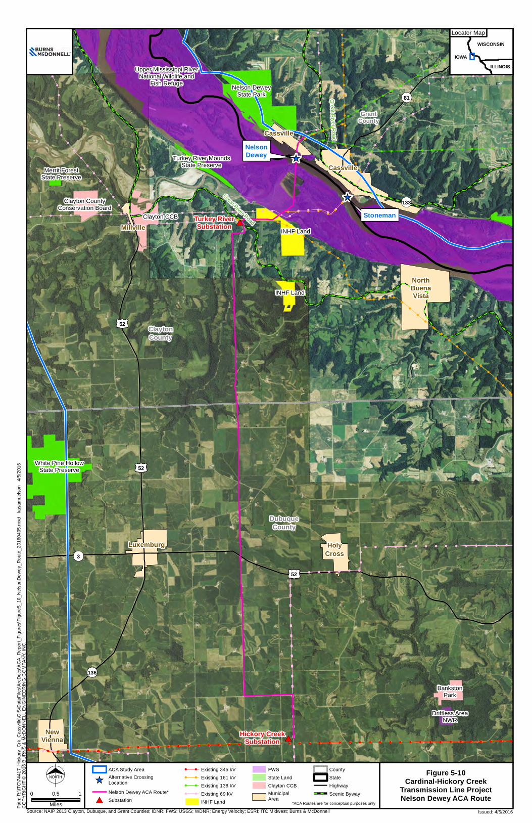
CO
PYR
IGH
T ©
201
6 B
UR
NS
& M
cDO
NN
ELL
EN
GIN
EER
ING
CO
MPA
NY,
INC
.
Source: NAIP 2013 Clayton, Dubuque, and Grant Counties; IDNR; FWS; USGS; WDNR; Energy Velocity; ESRI; ITC Midwest; Burns & McDonnell Issued: 4/5/2016
Path
: R:\I
TC\7
4417
_Hic
kory
_Crk
_Cas
svill
e\G
IS\D
ataF
iles\
ArcD
ocs\
AC
A_R
epor
t_Fi
gure
s\Fi
gure
5_10
_Nel
sonD
ewey
_Rou
te_2
0160
405.
mxd
ka
sam
uels
on
4/5/
2016
Figure 5-10Cardinal-Hickory Creek
Transmission Line ProjectNelson Dewey ACA Route
! ! ! ! ! ! ! ! ! ! ! ! !
!
! ! ! !!
!!
!! ! ! ! ! ! ! ! ! ! ! ! ! ! ! ! ! ! ! ! ! ! ! ! ! ! ! ! ! ! ! ! ! ! ! ! ! ! ! ! !
! ! ! !!
!
!
!
!
!
!
!
!!
!
!
!! ! !
!
!
!
!
!
!
!
!
!
!
!
!
!
!
!
!
!
!
!
!!
!!
!!
!
!!!!!!!!!!!!!!!
!!
!
! ! !!
!
!!!!!!!!!!!!
!
!
!
!
!
!
!
!
!
!
!!
!!
!!
!
!
!
!
!!
!!
!
!!
!!
!!
!
! ! ! !
!! !
! !
!!
!!
!
! ! ! ! ! ! ! ! ! ! ! ! ! !
!!
!
!!!!!!
!!
!!
!!
!!
!!
!!
!!
!!
!!
!
!!
! ! ! ! ! ! !
!!
! ! ! ! ! ! ! ! ! ! ! ! ! ! ! ! !
!!
!
!!!!!!!
!
! !!
!!
!!
! ! ! ! ! ! ! ! ! ! ! ! ! ! ! ! !
!!
!!
!!
!!
!!
!!
!!
!!
!
!
!
!!
!
!
!
!
!
!
!
!
!
!
!
!
!
!
!
!
!
!
!
!
!
!
!
!
!
!!
!
!
!!
!!
!!
!!
!!
!!
!!
!
!
!
!
!!
!
!
!
!
!
!
!
!!
!
! ! ! ! ! ! ! ! ! !
!
!
!!
!
!
! ! ! ! !! ! ! ! !
! ! ! !!
!
!
!
!
!
!
! !!
! ! ! ! ! ! ! ! ! ! ! ! ! ! ! ! ! ! ! ! ! ! ! ! ! ! ! ! ! ! ! ! ! ! ! ! ! ! ! ! !
!
!
!
!
!! ! ! !
!!
!!
!
! ! ! ! ! ! ! ! ! ! ! ! ! !
!!
!
! ! ! ! !
!
!
!!
!!
!!
!!
!!
!!
!!
!!
!!
!
! ! ! ! ! !
!! ! ! ! ! ! !
!!
! ! ! ! ! ! ! ! ! ! ! ! ! ! ! ! !
!!
!
! !!
! ! ! ! ! ! ! ! ! ! ! ! ! ! ! ! ! ! ! ! ! ! ! ! ! ! ! ! ! ! ! ! ! ! ! ! ! ! ! ! !
!!!!!!!!!!
#*
#*
_̂
_̂
£¤52
£¤52
¬«3
GrantCounty
ClaytonCounty
DubuqueCounty
¬«136
¬«81
¬«133
£¤52
Hickory CreekSubstation
Turkey RiverSubstation
NorthBuenaVista
Millville
NewVienna
Luxemburg HolyCross
Cassville
Cassville
Great R
iver Road
Great River Road
NORTH
0 10.5
Miles
ACA Study Area
_̂Alternative CrossingLocation
Nelson Dewey ACA Route*
#* Substation
! ! Existing 345 kV! ! Existing 161 kV! ! Existing 138 kV! ! Existing 69 kV
INHF Land
FWS
State Land
Clayton CCBMunicipalArea
County
State
Highway
Scenic Byway
Nelson DeweyState Park
INHF Land
INHF Land
Clayton CountyConservation Board
Clayton CCB
Merrit ForestState Preserve
White Pine HollowState Preserve
Driftless AreaNWR
BankstonPark
Upper Mississippi RiverNational Wildlife and
Fish Refuge
Driftless AreaNWR
Turkey River MoundsState Preserve
IOWA
WISCONSIN
ILLINOIS
MINNESOTALocator Map
*ACA Routes are for conceptual purposes only
Stoneman
NelsonDewey

Alternative Crossing Analysis Analysis ACA Routes, Alt. Crossing
ITC Midwest, ATC, DPC 5-72 Burns & McDonnell
(This page intentionally left blank)

Alternative Crossing Analysis Analysis ACA Routes, Alt. Crossing
ITC Midwest, ATC, DPC 5-73 Burns & McDonnell
Table 5-7: Potential Impact Summary Table for Nelson Dewey ACA Route
Criteria Output Criteria Output Engineering Social Total length (miles) 14.6 Residences within 0-25 feet (number) 0 Number of angles greater than 30 degrees 13 Residences within 26-50 feet (number) 1 Length not along transmission lines (miles) 12.7 Residences within 51-100 feet (number) 1 Length of Mississippi River crossing (miles) 0.3 Residences within 101-300 feet (number) 6 Airport, airstrip, or heliport within 1 mile (number) 0 Schools within 300 feet (number) 0 Water towers within 1,000 feet (number) 0 Daycares within 300 feet (number) 0 Communication facilities within 1,000 feet (number) 18 Hospitals within 300 feet (number) 0 Length through USACE restricted area (miles) 0.0 Places of worship within 300 feet (number) 0 Length through floodplain (miles) 0.8 Business/commercial structure within 300 feet (number) 0 Length through terrain with greater than 30% slope (miles) 0.1 Public facilities within 300 feet (number) 0 Environmental Cemeteries within 300 feet (number) 0 Total wetland acres in ROW (acres) 9.5 Archaeological sites in ROW (number) 1 Forested/shrub wetland in ROW (acres) 7.5 Historical resources within 1,000 feet (number) 1 Emergent wetland in ROW (acres) 2.0 Length not along actual fence row or property line (miles) 2.7 Total woodland acres in ROW (acres) 61.8 Length through developed space (miles) 3.3 Number of streams/waterways crossed 15 Length through cultivated crops (miles) 5.1 Length through state or local public lands (miles) 0.0 Length through pasture/hayland (miles) 0.5 Length through private conservation easements (miles) 0.5 Length through prime farmland (miles) 2.1
Length through USFWS Refuge (feet) 3,695.8 USFWS Refuge land within ROW (acres) 22.1 Parks within 1,000 feet (number) 0

Alternative Crossing Analysis Analysis ACA Routes, Alt. Crossing
ITC Midwest, ATC, DPC 5-74 Burns & McDonnell
Social Key characteristics of the potential impacts to social resources resulting from utilization of the Nelson
Dewey alternative crossing location are listed below. Similar to the Stoneman alternative, the nature of
the surrounding lands results in fewer residential or business/commercial proximity concerns compared to
the other alternatives. The output for the Nelson Dewey alternative also includes constraints for the first
one-half mile of the ACA route through Cassville, Wisconsin.
• The Nelson Dewey ACA route would have two residences within the Project ROW, the fewest of
any ACA route analyzed for the Project.
• The Nelson Dewey ACA route would not have a direct impact to any schools, places of worship,
or daycare facilities in Cassville, Wisconsin.
• The Nelson Dewey ACA route would encounter zero business or commercial properties, the
fewest of any alternative.
• The Nelson Dewey ACA route would include only one historical resource within 1,000 feet of the
preliminary route or corridor; identical to the Stoneman ACA route, this is the fewest number of
historical properties near any of the ACA routes. The Nelson Dewey ACA route would also have
one archaeological site within its ROW.
5.7.3.1.1 Environmental The Nelson Dewey ACA route was designed with a more direct route through the Refuge compared to the
Stoneman ACA route, which follows an existing ROW; as such, the amount of natural resources on
Refuge lands potentially affected by the Nelson Dewey ACA route are reduced compared to the
Stoneman ACA route. The following key characteristics are related to the potential impacts on
environmental resources resulting from using the Nelson Dewey alternative:
• The Nelson Dewey ACA route would have approximately 62 acres of woodland within its ROW
that would be cleared, which is the least amount of woodland clearing required by any ACA
route.
• The Nelson Dewey ACA route would result in a length of approximately 3,700 feet (less than
0.75 mile) over Refuge lands. This is approximately half the distance through the Refuge
compared to the Stoneman alternative crossing location.
• The Nelson Dewey ACA route would result in approximately 22 acres of Refuge lands within its
ROW, compared to 46 acres of Refuge lands within the Stoneman ACA route ROW.
• The Nelson Dewey ACA route would potentially impact approximately 9.5 acres of wetlands,
which is approximately 75 percent less than the Stoneman ACA route.

Alternative Crossing Analysis Analysis ACA Routes, Alt. Crossing
ITC Midwest, ATC, DPC 5-75 Burns & McDonnell
• Emergent wetlands underlying the Nelson Dewey ACA route would include approximately 2.0
acres, an approximate reduction of approximately 85 percent compared to the Stoneman ACA
route.
5.7.3.1.2 Engineering Key characteristics relating to the design and engineering required for the Nelson Dewey ACA route are
listed below. As with the Stoneman ACA route, the majority of engineering-related constraints for the
Nelson Dewey ACA route are located on or near the portion of the ACA route that extends through
Cassville, Wisconsin.
• The Nelson Dewey ACA route would result in approximately 13 miles of new line corridor not
located along an existing transmission line, slightly greater than the 11 miles of new transmission
line corridor for the Stoneman alternative.
• The Nelson Dewey ACA route would cross within 1,000 feet of 18 communication facilities,
while the Stoneman ACA route would only encounter two facilities at that same distance.
5.7.3.2 Additional Constraints and Feasibility There are several additional potential constraints for the Nelson Dewey ACA route. As with the Stoneman
ACA route, one of the key constraints is the potential impacts to avian resources that utilize both the
Refuge and the Mississippi Flyway. The potential impacts to these resources were presented above in
Section 5.5.2.3. As a result of the proximity of the Nelson Dewey ACA route to the Stoneman ACA route
(the two alternatives share the exact same starting point on Refuge lands and are only 1.2 miles apart at
the Mississippi River), and in comparison to the overall extent of the Refuge and the Mississippi Flyway,
the potential impacts to avian resources that are anticipated in general are not reiterated in detail in the
following discussion on the Nelson Dewey ACA route.
5.7.3.2.1 Avian Resources The Nelson Dewey ACA route would be a new transmission line corridor through the Refuge. It would
also allow for the associated removal and revegetation of two existing transmission line corridors
containing transmission lines, which would help to offset potential bird strikes in this area. The Nelson
Dewey ACA route would result in a shorter transmission line corridor through the Refuge relative to what
is currently present at the Stoneman location. Additionally, when compared to the wetlands and riparian
habitats underlying the existing corridor at Stoneman, the Nelson Dewey ACA route includes relatively
non-diverse, primarily row-crop agriculture habitats within the Refuge. The open and row-crop

Alternative Crossing Analysis Analysis ACA Routes, Alt. Crossing
ITC Midwest, ATC, DPC 5-76 Burns & McDonnell
agriculture areas of the Nelson Dewey ACA route would provide less diverse and suitable habitat for
supporting avian resources, compared to the Stoneman ACA route.
As with the Stoneman ACA route, the abundance and diversity of avian species in the Refuge results in
the potential for direct and indirect impacts to avian species. Similarly with the Stoneman ACA routes,
individual birds have the potential to be impacted at portions of the Nelson Dewey ACA route and at
portions off the Refuge by collisions with the conductors, static wires, or other infrastructure. The Nelson
Dewey ACA route is not anticipated to have potential impacts at the population level for avian species or
to migratory pathways. Indirect benefits to avian species as a result of the Nelson Dewey ACA route
include the revegetation of the existing transmission line corridor that would be removed through the
Refuge, thus creating potential habitat for avian species that prefer wetlands, habitat edges, and early
successional riparian forests.
The design and the location of the Nelson Dewey ACA route follows the “minimization” portion of the
USFWS mitigation process to avoid, minimize, and mitigate/compensate. The Nelson Dewey ACA route
would incorporate strategies to minimize environmental impacts to the avian species, in consultation with
the USFWS. These measures include, but are not limited to, minimizing the distance of new transmission
line ROW on the Refuge through the creation of a relatively straight path. Similar to the Stoneman ACA
route, within the Refuge all conductors would be placed within the same horizontal plane to minimize the
number and height of visible conductors for potential interaction with birds. The existing transmission
lines in the Refuge that would be removed have a vertical configuration that has more potential for
interaction with birds. The static wires would be marked with avian flight diverters in compliance with
USFWS and Refuge consultation as well as guidance from the APLIC’s Reducing Avian Collisions with
Power Lines: The State of the Art in 2012 (APLIC, 2012). The two transmission lines at Stoneman that
would be removed as a result of the construction of the Nelson Dewey alternative are shorter in height
(approximately 56.5 feet) than what is proposed for the Nelson Dewey ACA route, but the existing
transmission lines do not include any avian diverters or line markings and are located in habitat deemed to
be more important to avian and wildlife resources than that underlying the Nelson Dewey ACA route. As
with the Stoneman alternative crossing location, the Mississippi River crossing structure and the
associated conductors and static wires near the Mississippi River would need to be taller (approximately
198 feet to allow the overhead transmission line to cross the waterway at a height that is permittable by
the U.S. Coast Guard.
The Nelson Dewey ACA route would likely provide an overall benefit to avian resources in the area,
relative to the existing Stoneman transmission infrastructure, or the proposed Stoneman ACA route. The

Alternative Crossing Analysis Analysis ACA Routes, Alt. Crossing
ITC Midwest, ATC, DPC 5-77 Burns & McDonnell
Nelson Dewey ACA would be located in a relatively open area, configured with conductors along a
horizontal plane, include relatively short span thus decreasing overall line height, and include markings
on the shield wires to minimize avian collisions compliant with APLIC 2012 guidelines. This design
would create a more visible structure and conductor compared to the existing 69 kV and 161 kV lines at
the Stoneman location. Additionally, the existing Stoneman transmission line ROW would be allowed to
revegetate naturally, providing diverse and additional resources to avian and wildlife species that require
disturbance, openings, or diverse microclimates in forested areas.
5.7.3.2.2 Archaeological and Historic Resources As with the Stoneman ACA route, there is one archaeological site, 13CT3 (also known as Pete Adams
Mound Group 4), within the Nelson Dewey ACA route ROW. There are no identified historic sites within
the ROW. Potential impacts to historic-age resources would be the generally similar as described under
the Stoneman alternative crossing location.
Any removal or excavation of archeological resources within the Refuge (would require an
Archaeological Resources Protection Act of 1979 (ARPA) permit. Activities with the Refuge area also
subject to Section 106 of the National Historic Preservation Act.
5.7.3.2.3 Oak Road and Ferry Crossing The Nelson Dewey ACA route would also cross the Cassville Car Ferry route. The Cassville Car Ferry
takes passenger cars from Cassville to the landing on Oak Road in Iowa. The ferry has been in service
since 1833 and is the oldest operating ferry service in Wisconsin. The ferry connects two scenic byways:
the Iowa Great River Road and the Wisconsin Great River Road (Village of Cassville, 2015b). The
Nelson Dewey alternative crossing location would require a structure close to the ferry landing on the
Iowa side of the river near Oak Road; during construction, this could temporarily impact accessibility of
the ferry landing area.
5.7.4 Summary of Refuge Options The three Refuge ACA routes are located in two primary locations, Guttenberg, Iowa, (L&D 10) and near
Cassville, Wisconsin, (Nelson Dewey and Stoneman), with each location having notable differences in
the type and extent of constraints and potential impacts. L&D 10 does not have an existing transmission
line crossing at its location; a new 345 kV transmission line at this location would be required to span
approximately 1.4 miles of the Mississippi River and would encounter substantial archaeological and
historical resources in and near the City of Guttenberg in addition to the technical issues around such a
long span over water. Importantly, the USACE review of the Project at this location noted numerous
Alternative Crossing Analysis Analysis ACA Routes, Alt. Crossing
ITC Midwest, ATC, DPC 5-78 Burns & McDonnell
technical issues and concerns with placing a 345 kV transmission line on or near the lock and dam
infrastructure, resulting in the exclusion zones shown in Figure 5-8. As a result of these factors, the
Utilities do not consider the L&D 10 alternative crossing location as feasible for this Project.
Both remaining Refuge locations, Nelson Dewey and Stoneman, are considered by the Utilities as feasible
ACA routes for the Project.
The Nelson Dewey and Stoneman Refuge crossings are generally similar in location, but offer important
distinctions between their constraints. Within Refuge lands, the Nelson Dewey ACA route would require
less length and new ROW habitat alterations through the Refuge, remove less emergent and forested
wetland from within the ROW, and would require fewer woodland areas to be removed. It is anticipated
that the Nelson Dewey ACA route would provide an overall benefit to avian resources and wildlife when
compared with the Stoneman ACA route as a result of the available habitat types and general location of
the Stoneman alternative crossing location compared to the Nelson Dewey ACA route.
Across the Mississippi River in Cassville, Wisconsin, the Nelson Dewey ACA route extends through
relatively undeveloped lands to connect with existing transmission line corridors which eventually lead to
an intermediate substation near Montfort, Wisconsin. At Cassville, the Stoneman ACA route would
extend directly through the Village of Cassville and would encounter numerous routing constraints that
include residences, businesses, and schools within or immediately adjacent to the Project ROW.
Additionally, selection of the Nelson Dewey alternative crossing location would prevent potentially
lengthy electrical outages that would occur if the Stoneman alternative is selected, which would require
taking these lines out of service for construction activities.
Additional comparative information for these two remaining feasible Refuge ACA routes is presented in
Chapter 8.0.
5.8 Underground Construction Options As part of this analysis, USFWS requested an evaluation of underground design for the Project. The
Utilities prepared an Evaluation of Underground Transmission Installation Report (Appendix D). The
following discussion presents a summary of this document.
5.8.1 Potential Locations for Underground Construction Two potential underground alternatives (the Stoneman and Nelson Dewey underground crossing
alternatives) were analyzed for the Project. (The Utilities completed this underground analysis while they
were only contemplating a 345 kV/161 kV crossing. Accordingly, the analysis presented here and in

Alternative Crossing Analysis Analysis ACA Routes, Alt. Crossing
ITC Midwest, ATC, DPC 5-79 Burns & McDonnell
Appendix D pertains only to a 345 kV/161 kV underground alternative.) An initial assessment of the
potential for an underground alternative at the other five alternative crossing locations was completed by
the Utilities. As a result of the constraints encountered to access these locations for an underground
crossing, and the lack of agency and/or municipality permitting or approval for preliminary or corridors to
each of these alternative crossing locations, it was determined that further investigation of an underground
alternative at these locations was not warranted at this time.
The Nelson Dewey underground crossing alternative would be placed in a new corridor. The Stoneman
underground crossing alternative would utilize a portion of the existing overhead 161 kV corridor for
placement of the underground alternative. The locations of the two underground route alternatives were
selected to minimize the potential impact on the environment and Refuge lands. The preliminary routing
options investigated as part of the feasibility study include (note the routes are described from east to
west):
• The Stoneman underground crossing alternative starts southeast of the Village of Cassville and
heads west to the Stoneman Substation then continues west/southwest under the Mississippi
River channel to the western river limits near the existing overhead alignment. From this location,
the underground alternative continues southwest slightly north of the current overhead alignment
before rejoining the existing overhead alignment. From this location the preliminary corridor
turns back west and extends within the overhead alignment to the riser pole location near the
railroad tracks where the alternative would continue as an overhead line. The Stoneman
underground crossing alternative would include approximately 9,600 feet of total underground
length.
• The Nelson Dewey underground crossing alternative is in a new corridor. The proposed 345
kV/161 kV underground crossing starts at the southeast corner of the Nelson Dewey Substation,
heads southwest to the east bank of the Mississippi River and continues southwest under the
channel to the existing western river limits near the Cassville Ferry Landing boat ramps. From
this location, the underground alternative continues to the southwest, in a straight alignment to the
existing overhead transmission line corridor to the riser pole location near the railroad tracks. The
alternative would continue west as an overhead line from the riser pole. The Nelson Dewey
underground crossing alternative would include approximately 7,900 feet of total underground
length.

Alternative Crossing Analysis Analysis ACA Routes, Alt. Crossing
ITC Midwest, ATC, DPC 5-80 Burns & McDonnell
5.8.2 Review of Potential Costs Preliminary construction cost estimates were developed based on the preliminary underground
alternatives, installation methods, and cable system(s), as evaluated in the full underground installation
report (Appendix D). These cost estimates are based on RSMeans Heavy Construction Cost Data as well
as past projects, budgetary quotes provided by vendors, and professional experience. An underground
design would add an estimated $80 million to $100 million (depending on the final route selected), to a
total Project cost, representing a more than 20 percent cost increase for the total Project. The increase in
costs associated with an underground alternative for the Project could potentially require additional
review by MISO.
• The total cost estimate for placing the 345 kV/161 kV Nelson Dewey crossing underground is
$82.0 MM.
• The total cost estimate for placing the 345 kV/161 kV Stoneman crossing underground is $97.6
MM.
More detailed breakdowns of these costs can be found in Appendix D.
5.8.3 Analysis of an Underground Alternative at the Refuge The underground crossing alternatives would result in potential impacts to environmental and social
resources as well as engineering constraints. USFWS staff have yet to determine the environmental
impacts of an underground alternative; it is the Utilities’ understanding that the USFWS will use this
report (and the included underground report found in Appendix D) as a starting point for its evaluation of
the Refuge crossings proposed in this ACA, including the underground alternative.
5.8.3.1 Wetlands The two underground alternatives have wetlands within their respective ACA routes. The wetlands
potentially impacted by the location of the underground corridors are primarily designated as
forested/shrub wetlands and emergent wetlands. Riser poles would be required for both underground
crossing scenarios and underground construction types. The riser poles would require the conversion of
approximately 1.0 acre of land. The currently proposed riser pole locations are within the Refuge on land
classified as emergent wetland and a very small area of forested/shrub wetland. The proposed eastern and
western transition stations would be located outside of Refuge boundaries on the eastern side of the
Mississippi River and at the rebuilt Turkey River Substation, respectively.

Alternative Crossing Analysis Analysis ACA Routes, Alt. Crossing
ITC Midwest, ATC, DPC 5-81 Burns & McDonnell
Both underground construction options would require underground splice vaults every 1,750 feet. Each
vault is approximately 50 feet by 150 feet. It is anticipated that both alternatives would require a total of
five splice locations, each containing four vaults (three for the 345 kV line and one for the 161 kV line)
for a total of 20 vaults within the Refuge. Although the actual locations of these vaults are not known at
this time, due to the presence of wetlands in this area (particularly underlying the Stoneman underground
alternative which has more wetland habitat), it is likely a majority of the acreage required for vault
construction would occur in designated wetlands. In addition, vegetation management areas would be
required near these splice vault locations so that root incursion into the underground cable systems would
be prevented with a minimum cleared area of 7,500 square feet per vault.
In comparing the two types of underground construction, the open trench method would require the
excavation of a utility corridor through the entire Refuge, including wetland areas. Measures to avoid
wetlands in the final alignment for construction would be employed; however, as a result of the extensive
wetlands in this area, permanent wetland impacts potentially would occur where vegetation removal and
soil excavation is required. The open trench method would cross approximately 1,100 feet of wetlands
under Nelson Dewey crossing alternative and approximately 7,000 feet of wetlands under the Stoneman
crossing alternative. The proposed horizontal directional drilling (HDD) option would also require a new
utility corridor through both the Refuge and wetland areas, but potential impacts to wetlands would be
minor outside of the staging and splice vault areas, as the HDD method would extend underneath wetland
areas through the Refuge. Splice vaults would be required at the same five locations and would be
installed by excavation. Vegetation management would be required in and around the riser poles and the
splice vaults to allow for safe operation of the cable systems. In these areas, existing forested/shrub
wetland vegetation, if present, would be permanently removed. Trench backfilling for this underground
alternative would generally not be completed using the native soil material; heat-dissipating sand is used
for the 42+ inch trench depth and removal of the native material would be required. This would include
adding non-native fill to Refuge lands and to wetlands along the underground alternative route.
5.8.3.2 Land Cover and Land Use In the vicinity of the Refuge are areas of open water, developed open space, low intensity development,
deciduous forest, grassland/herbaceous area, pasture/hay fields, cultivated crops, forested/shrub wetlands,
and emergent herbaceous wetlands. Several residences are near the Stoneman and Nelson Dewey
underground alternatives, including the Promiseland Winery and Vineyard operation close to the Turkey
River Substation location. A small private parcel is located within the Refuge boundaries and would be
traversed by the Nelson Dewey underground alternative; this area is currently used for cultivated crops. In
addition, another smaller private parcel that parallels the rail line on the western edge of the Refuge is

Alternative Crossing Analysis Analysis ACA Routes, Alt. Crossing
ITC Midwest, ATC, DPC 5-82 Burns & McDonnell
located just north of the Nelson Dewey underground alignment. A parcel of land managed by the INHF
would be traversed by the Stoneman underground alternative.
The scenic views of the Refuge attract hundreds of visitors each year for a variety of activities, such as
hiking and boating. As a result of the area topography, some construction activities would likely be
visible from vantage points around the Refuge, but this would be limited to major construction activities.
Visual evidence of underground transmission infrastructure through the Refuge would include the area
cleared for splice vault locations along the buried cable corridor, the riser pole area, and access roads to
reach both the vault locations and the riser pole area. The transition station itself would also be visible,
but would be located at the rebuilt Turkey River Substation. Permanent vegetation removal would be
required at these locations and would be evident from elevated views surrounding the Refuge.
It is anticipated that either underground alternative would require 20 vaults within the Refuge. At each of
these locations, the transmission line would need to be slightly closer to the surface grade. This proximity
may affect soil composition and seed germination in the surrounding vegetation due to possible heat
transfer when the conductors are buried at a shallower depth. A proposed re-vegetation plan to address
this issue would be developed in consultation with the USFWS.
5.8.3.3 Floodways/Floodplains FEMA designates areas that are likely to experience flooding in a 100-year storm event. Since the Project
is in such close proximity to the Mississippi River, much of the routes are in Zone AE or X. Zone AE
includes areas subject to inundation of floodwater by the 1-percent annual chance flood event, also known
as a 100-year floodplain (FEMA, 2015). The segments in Zone X have moderate risk within the 0.2-
percent-annual-chance (or 500-year) floodplain. Zone X also includes areas of 1-percent-annual-chance
flooding where average depths are less than 1 foot and areas of 1-percent-annual-chance flooding where
the contributing drainage area is less than 1 square mile, both of which present a moderate risk of flood.
Outside of the 100-year and 500-year floodplains, there is minimal risk of floods.
The segments through Zone X are those that are on the bluffs above the Mississippi River. This area is
more than 200 feet higher in elevation than those areas in the 100-year floodplain closer to the river.
There may be fewer potential impacts to floodplain areas if the HDD method is utilized compared to the
open trench option, depending on differences in the amount and location of staging areas in relation to a
specific route alignment. In general, the open trench would potentially require more of a construction
footprint within the floodplain during construction, but may result in a reduced permanent impact in terms

Alternative Crossing Analysis Analysis ACA Routes, Alt. Crossing
ITC Midwest, ATC, DPC 5-83 Burns & McDonnell
of permanent ROW compared to the HDD method, as a result of the narrower operation footprint
compared to HDD.
Approximately half of the underground corridor would need to be placed within FEMA-designated 100-
year floodplains. The proposed Project is not anticipated to cause a potential reduction in floodflows or
reduction in flood storage volumes in the vicinity of the Refuge. The infrastructure required to operate the
underground 345 kV cable systems within the floodplain would be limited in size, but would result in the
permanent conversion of land designated as floodplain within the ROW for each construction method.
Construction within the floodplain would increase the potential for issues with maintenance access,
particularly during severe weather events and certain seasonal conditions, particularly flooding.
5.8.3.4 Cultural Resources An assessment of Iowa cultural and archeological resources in the surrounding area identified
archaeological sites listed on the NRHP as well as other recorded sites. Data was obtained from the Iowa
SHPO.
The Nelson Dewey underground crossing alternative would cross in proximity to one mound group,
thought to be from the Woodland period. This mound group has only been investigated through archival
research and thus its integrity is unknown. If an underground alternative were chosen, the mound group
location would need to be verified and its integrity investigated with SHPO consultation prior to start of
construction activities. This site has not been evaluated to determine its eligibility for listing on the
NRHP. The Stoneman underground crossing alternative would have two archeological resources within
the projected ROW width. According to data obtained from the Iowa SHPO, these two resources are
burial mounds that were previously destroyed. There are no known historical structures identified within
1,000 feet of either alternative underground route. Overall, within the Refuge, there have been 108
archaeological, geomorphological, history, and research investigations that have produced more than
129,000 artifacts (USFWS, 2006). Any removal or excavation of archeological resources within the
Refuge would require an Archaeological Resources Protection Act of 1979 (ARPA) permit. Activities in
the Refuge are also subject to Section 106 of the National Historic Preservation Act.
5.8.3.5 Existing or Planned Development Several areas with existing or planned development are in the general vicinity of the proposed
underground alternatives. The Nelson Dewey underground crossing alternative would be near the launch
for the Cassville Car Ferry, a passenger ferry between Cassville, Wisconsin, and Oak Road in Clayton
County, Iowa. Construction of the Nelson Dewey underground crossing alternative may temporarily

Alternative Crossing Analysis Analysis ACA Routes, Alt. Crossing
ITC Midwest, ATC, DPC 5-84 Burns & McDonnell
disrupt the ferry service as closures of Oak Road might be required during trenching and installation of
the underground transmission line. Also, depending on the crossing location selected, required
construction activities near the Mississippi River may disrupt normal operations of the ferry.
An active Canadian Pacific railroad extends northwest to southeast along the Mississippi River and would
need to be crossed by either underground alternative. Potential boring activities at the site may require
disruption of normal rail traffic through the area.
5.8.3.6 Navigation Considerations Barges, boats, and other river vessels utilize the Mississippi River channel near the potential underground
transmission crossings. Construction timing would be coordinated with the U.S. Coast Guard to avoid
potential impacts to Private Aids to Navigation in this portion of the Mississippi River. Closures of the
Mississippi River channel near either the Nelson Dewey or Stoneman may be required during
construction activities. These closures would need to be coordinated by the Utilities, the USFWS, the
USACE, and the U.S. Coast Guard in terms of the planned duration and extent of the navigation
considerations on the river.
Periodic maintenance of all transmission facilities would be required. Impacts to navigation aids on the
Mississippi River are not anticipated as a result of operation of either underground construction scenario
or crossing location. Significant delays to maritime traffic on the Mississippi River are not anticipated to
result from either construction activities or ongoing maintenance.
5.8.3.7 Access Considerations Where no current access is available or existing access is inadequate to cross roadway ditches or other
features, new access roads may be constructed. Permission from landowners and/or land managers would
be obtained prior to using any of these areas to access the ROW for construction. Where necessary to
accommodate heavy construction equipment, including cranes, cement trucks, and hole-drilling
equipment, existing roads may be upgraded or new roads may be constructed. If new roads must be
constructed, in addition to permission from landowners, the Utilities would also obtain permissions
necessary from the local road authority. During construction activities, the Utilities would work with
appropriate road authorities to utilize proper maintenance procedures of roadways traversed by
construction equipment.
Ground-level vegetation disturbed or removed from the ROW during construction of either underground
alternative would naturally reestablish to pre-construction conditions. Areas where significant soil
compaction or other disturbance from construction activities occur would require additional assistance in

Alternative Crossing Analysis Analysis ACA Routes, Alt. Crossing
ITC Midwest, ATC, DPC 5-85 Burns & McDonnell
re-establishing the vegetation and controlling soil erosion. BMPs to be used during the construction of the
Project would be identified in a Storm Water Pollution Prevention Plan.
5.8.4 State Regulatory Considerations Increased costs due to undergrounding may create significant challenges in obtaining state approvals in
Iowa and Wisconsin. The PSCW siting authority requires that the benefits of the Project be reasonable in
relation to cost.34 Due to the significantly higher costs associated with underground construction, the
PSCW has previously held that underground construction “is not a viable transmission construction
option unless engineering considerations require it or circumstances leave no other reasonable option
available.”35 In that same decision, the PSCW noted that an underground crossing has its own
environmental impacts, and that “the transition stations required for underground crossings… would
present undesirable aesthetic impacts of their own.”36 The PSCW is also concerned about limited access
for repairs and ROW congestion problems associated with undergrounding transmission lines.37
Consequently, the PSCW has limited approval of underground transmission lines to situations where
there is “a reliability issue, building clearance concerns, or a nearby airport.”38
Similarly, the IUB frequently denies requests to underground transmission lines because it is not “fair,
just, or proper” to require ratepayers to pay the increased expense of underground construction39 which
34 Wis. Stat. § 196.491(3)3t (2014). 35 Joint Application of Dairyland Power Cooperative, Northern States Power Company-Wisconsin, and Wisconsin Public Power, Inc., for Authority to Construct and Place in Service 345 kV Electric Transmission Lines, Docket No. 5-CE-136, Final Decision at 36 (May 30, 2012) [hereinafter La Crosse Project Final Decision]; Joint Application of Wisconsin Electric Power Company, for Authority to Construct a New Distribution Substation and Related Electric Distribution Facilities in the City of Wauwatosa and American Transmission Company, LLC, for Authority to Construct Related 138 kV Electric Transmission Facilities in the Cities of Milwaukee and Wauwatosa, Docket No. 5-CE-139, Final Decision at 32 (Mar. 20, 2013)[hereinafter Western Milwaukee County Electric Reliability Project] (“use of underground construction should in general be limited to where it is technically necessary and no reasonable options exist”). 36 La Crosse Project Final Decision at 36. 37 Western Milwaukee County Electric Reliability Project at 32; see also, Application of American Transmission Company to Construct a New 138 kV Line from the North Madison Substation to the Huiskamp Substation in the Towns of Vienna and Westport and the Village of Waunakee in Dane County, WI, Docket No. 137-CE-139, FINAL DECISION at 20 (July 7, 2007) (discussing excessive cost of undergrounding and increased time and difficulty associated with repairing underground lines). 38 Western Milwaukee County Electric Reliability Project at 32. 39 In re: MidAmerican Energy Company, Docket Nos. E-21752, E-21753, E-21754, 2006 WL 2134555, Proposed Decision and Order Granting Franchises at *14 (Iowa U.B. July 26, 2006) (denying request to underground because the cost of underground construction can be as much as ten time the cost of overhead construction), aff’d, 2006 WL 2710649, Order Affirming Proposed Decision and Order Granting Franchises (Iowa U.B. Sept. 12, 2006); e.g., In re: ITC Midwest LLC, Docket Nos. E-21948, E-21949, E-21950, E-21951, Order Denying Petition for Limited Intervention and Granting Petitions for Electric Franchises at 79 (Iowa U.B. June 1, 2011) (affirming Board staff engineers’ determination that undergrounding transmission line was not economically feasible); In re: Cedar Falls

Alternative Crossing Analysis Analysis ACA Routes, Alt. Crossing
ITC Midwest, ATC, DPC 5-86 Burns & McDonnell
can be “as much as ten times as much the cost of overhead construction.” Overall, the Utilities believe
that the significant increase in Project cost associated with underground construction; the potential impact
on Refuge lands related to underground construction; and, the regulatory challenges do not warrant
further evaluation of underground construction.
Utilities, Docket No. E-21647, 2005 WL 7138145, Proposed Decision and Order Granting Franchise at *9 (Iowa U.B. July 6, 2005), aff’d, 2005 WL 2860287, Order Affirming Proposed Order, Addressing Motions, and Granting Permission to Appear (Iowa U.B. Sept. 21, 2005) (affirming decision not to underground because cost of underground construction was over five time that of overhead construction).