carnotite-bearing sandstone in cedar canyon, slim … · a contribution to the geology of uranium...
TRANSCRIPT

Carnotite-bearing Sandstone in CedarCanyon, Slim ButtesHarding CountySouth Dakota
GEOLOGICAL SURVEY BULLETIN 1009-1
This report concerns work done on behalf of the U. S. Atomic Energy Commission
* and is published with the permission of the Commission

A CONTRIBUTION TO THE GEOLOGY OF URANIUM
CARNOTITE-BEARING SANDSTONE IN CEDAR CANYON, SLIM BUTTES, HARDING COUNTY, SOUTH DAKOTA
BY JAMES R. GILL AND GEORGE W. MOORE
Carnotite-bearing sandstone and claystone have been found in the Chadron formation of the White River group of Oligocene age in the southern part of the Slim Buttes area, Harding County, S. Dak. The carnotite is an efflorescent yellow coating on lenticular silicified sandstone. Locally, the mineralized sand stone contains 0.23 percent uranium. The uranium and vanadium ions are believed to have been derived from the overlying mildly radioactive tuffaceous rocks of the Arikaree formation of Miocene age. Analyses of water from 26 springs issuing from the Chadron and Arikaree formations along the margins of Slim Buttes show uranium contents of as much as 200 parts per billion. Meteoric water percolating through tuffaceous rocks is thought to have brought uranium and other ions into environments in the Chadron formation that were physically and chemically favorable for the deposition of carnotite.
INTRODUCTION
Carnotite was found on March 15, 1953, in Cedar Canyon in the southern part of the Slim Buttes area in the NE^NEX sec. 8, T. 16 N., R. 8 E., Harding County, S. Dak. Carnotite has been found since in the Chadron formation at two other places in the Slim Buttes region, and the known area of the carnotite deposits in Cedar Canyon has increased.
A geologic and topographic map (pi. 10) shows the stratigraphic and topographic relations of the mineralized sandstone to the under lying and overlying rocks. The map, made by planetable and alidade, covers an area of 1,550 by 1,870 feet at a scale of 1:2400. A second geologic map (pi. 11) was prepared at a scale of 1:31,680 to show the relation of the geologic features of the Cedar Canyon area to similar features in adjacent areas. Other carnotite localities are shown on this map, which may also serve as a guide for future in vestigations in the southern part of the Slim Buttes area.
This investigation was undertaken on behalf of the Division of Raw Materials of the Atomic Energy Commission as a part of a program conducted in search for and appraisal of uranium-bearing carbonaceous rocks in the Rocky Mountain region.
Many geologists have contributed to knowledge about the Slim Buttes area. The lignite resources have been investigated by
249

250 CONTRIBUTIONS TO THE GEOLOGY OF URANIUM
Winchester, Hares, Lloyd, and Parks (1916), the structural geology in relation to oil and gas by Toepelman (1923), and the general geolog}7 by Baker (1952). The origin of uraniferous lignites has been discussed in written communications by N. M. Denson and others (1950), E. P. Beroni and H. L. Bauer, Jr. (1952), and H. D. Zeller (1952).
The writers received assistance from Roy C. Kepferle, Murray Levish, and Robert E. Melin during the fieldwork and the preparation of this report. James D. Bump of the South Dakota School of Mines visited the area and helped to correlate the Oligocene rocks with the rocks of the White River badlands in Pen.ningto.ii and Washabaugh Counties about 150 miles southeast of the Slim Buttes.
The writers appreciate the many courtesies extended by local ranchers, particularly William and Esther Warn men. Vernon Wammen provided great assistance by helping the authors to obtain oblique aerial photographs of the Cedar Canyon caraotite deposit.
LOCATION AND ACCESSIBILITY OF AREA
The Slim Buttes area lies within the Custer National Forest in the southeast part of Harding County, S. Dak. It is about 30 miles southeast of the town of Buffalo and" about 60 miles north of the town of Newell, the nearest rail shipping point. The mapped area covers parts of Tps. 16 and 17 N., Rs. 7, 8, and 9 E.
A well-graded county road crosses the area and connects State Highway 8, about 11 miles north of the area, with U. S. Highway 212 at Newell. The parts of the area not accessible by this county road can be reached by dirt ranch roads and Forest Service trails.
The Slim Buttes form a rugged and imposing topographic feature in contrast to the surrounding gently rolling plains. Steep cliffs, which form the margins of the Slim Buttes, are as high as 250 feet and are broken at several places by V-shaped canyons. Steep-walled gullies and landslide blocks make travel along the base of the cliffs difficult. Along the base of the cliffs springs are common, but perennial streams are absent.
STRATIGRAPHY
The rocks exposed in the southern part of the Slim Buttes area range in age from Late Cretaceous to Recent. All the rocks are continental in origin, but conditions of sedimentation ranged from those favoring the deposition of lignite to those favoring the accumula tion of volcanic ash. The sequence of sedimentation has been broken by at least two major periods of erosion, which are shown by two unconformities: one at the base of the rocks of Oligocene age and the other at the base of the rocks of Miocene age.

CARNOTITE-BEARING SANDSTONE IN CEDAR CANYON, S. DAK. 251
UPPER CRETACEOUS ROCKS
HEM, CREEK FORMATION
The oldest rocks exposed in the mapped area of the southern part of the Slim Buttes are those which have'been assigned to the Hell Creek formation. The Hell Creek formation is Late Cretaceous in age and is composed of continental sediments that are about 400 feet thick. Along the North Fork Moreau River, 17 miles south of the mapped area, the Hell Creek formation rests on the marine Fox Hills formation, also of Cretaceous age.
The Hell Creek formation in the mapped area consists largely of medium-grained greenish-gray friable sandstone and dark-gray sandy ben to nitic shale. Thin beds and concretions of medium- grained sandstone cemented by siderite are generally abundant. The siderite is commonly weathered to limonite on the surface, and in fresh exposures it is brownish black. Loglike dark-yellowish- brown calcareous concretions as much as 10 feet long occur in the friable sandstone. Thin lenticular beds of lignite occur in the upper part of the formation.
The contact between the Hell Creek formation and the overlying Ludlow member of the Fort Union formation is not obvious in the area. The units were distinguished by earlier workers (Winchester, Hares, Lloyd, and Parks, 1916, p. 19) on the basis of the lithologic change from the somber-colored rocks of the Hell Creek formation to the yellowish-brown rocks of the Fort Union formation. In the southern part of the Slim Buttes area this criterion is difficult to apply because the two lithologic types alternate for a vertical dis tance of 100 feet or more. In this report the contact has been placed at the base of the lowest persistent lignite bed (Brown, 1952). In most of the area this lignite bed lies below a resistant dark-yellowish- brown sandstone bed.
TERTIARY ROCKS
FORT UNION FORMATION
The Ludlow member of the Fort Union formation of Paleocene age conformably overlies the Hell Creek formation and is separated from it by a transitional zone. The Ludlow member is composed largely of poorly cemented yellowish-brown very fine grained sandstone interbedded with carbonaceous shale and lignite. Moderately well indurated, medium-grained sandstone is found also.
In the mapped area the Ludlow member of the Fort Union forma tion ranges in thickness from a featheredgc to about 100 feet. Expo sures of this formation to the north of the mapped area indicate that it was originally more than 300 feet thick and was conformably overlain by at least 300 feet of sandstone and shale of the Tongue

252 CONTRIBUTIONS TO THE GEOLOGY OF URANIUM
River member. Erosion preceding deposition of the White River group has truncated the northeastward-dipping Fort Union forma tion, resulting in the thinning of the formation in the mapped area and, locally, in its complete removal.
Lignite has been mined from the Ludlow member of the Fort Union formation at several localities within the Slim Buttes. The discovery that some of the beds in the southern part^of Slim Buttes contain uranium was made in 1950 (N. M. Densori and others, written communication). However, no uranium minerals are apparent in the lignite, and the uranium is thought to be retained as a metallo- organic constituent (I: A. Breger and Maurice Deul, written com munication, 1952).
WHITE RIVER GROUP
The White River group of Oligocene age unconformably overlies both the Fort Union and Hell Creek formations. The White River group consists of the Chadron and Brule formations.
The Chadron formation is the basal formation and is the only part of the group generally present throughout most of the mapped area. Pre-Arikaree erosion has removed the overlying Brule forma tion in many areas. The lower part of the Chadron formation con sists of medium-yellow to dark-yellowish-orange sandstone and siltstone, and in some localities contains much material reworked from the Fort Union and Hell Creek formations. At a, few places the formation contains beds of detrital lignite, as much as 6 inches thick, derived and reworked from the underlying Ludlow member of the Fort Union formation. The upper part of the Chadron forma tion is composed mainly of white fine- to coarse-grained pebbly sand stone, and light-olive-gray bentonite. Tuffaceous sandstone and opalized clay are present locally. Where the reworked material is absent, the white sandstone of the upper part of the Chadron forma tion rests on older rocks.
The Brule formation is exposed at only three localities within the mapped area at the north end of Flat Top Butte, chiefly in sees. 29 and 30, T. 17 N., R. 9 E., west of Square Top Butte in sec. 31, T. 17 N., R. 8 E., and along the south face of Slim Buttes in sec. 14, T. 16 N., R. 8 E. In all of these areas the Brule formation is preserved in landslide blocks which were dropped before the deposition of the Arikaree formation. The contact between the Brule and the Chadron formations is exposed at the north end of Flat Top Butte. The authors followed a practice that originated in the Big Badlands area where the classic White River exposures are found. The practice is to place the contact at the top of a fresh-water limestone bed which separates the uppermost bentonite bed of the Chadron formation from the orange-pink sandy claystone and tuffaceous sandstones of the Brule

CARNOTITE-BEARING SANDSTONE IN CEDAR CANYON, S. DAK. 253
formation (Bump, 1951). The Brule formation is composed of tiiin- bedded to massive sandy claystone and tuffaceous sandstone, which are well indurated and contrast sharply with the poorly cemented sandstone and bentonitic clay of the Chadron formation. (See fig. 40.)
FLAT TOP BUTTESEifi sec. 30, T.I7N., R.9E.
FINGER BUTTESW/4 sec. 35, T.I7N..R.8E.
CEDAR CANYONNEis. sec. 8, T. 16 N., R.8E.
ANTELOPE CREEKSEfc sec. 12, T..I6N., R.8E
I I II I II I I
I I I I I I
FIGURE 40. Stratigraphic sections of rocks exposed in the southern part of Slim Buttes. Harding County, S. Dak.
In some areas the White River group is absent and the Arikaree formation rests directly on the older rocks. This condition occurs in sees. 11 and 14, T. 16 N., R. 8 E. Before the deposition of the White River group, resistant sandstone beds in the Ludlow member of the Fort Union formation and Hell Creek formation formed hills having
3<I3704 55 2

254 CONTRIBUTIONS TO THE GEOLOGY OF URANIUM
as much as 100 feet of relief. Only a thin mantle of Chadron was deposited on these hills, and subsequent pre-Arikaree erosion removed this mantle to expose some of these ancient hills.
Rocks of the White River group contain, on the average, about 0.0010 percent uranium.
ARIKAREE FORMATION
The Arikaree formation of Miocene age unconformably overlies the rocks of the White River group. No diagnostic fossils have been found in this unit in northwestern South Dakota, and the correlation with the Arikaree formation of Miocene age in southwestern South Dakota and southeastern Montana is made on the basis of lithologic similarities. A beaver of late Miocene age from the Arikaree formation has been described by Wood (1945) from rocks in southeastern Mon tana; these rocks are lithologically similar and correlate with those in the Slim Buttes.
The Arikaree formation is resistant to erosion and is the rock unit that causes the tops of the Slim Buttes to stand more than 500 feet higher than the surrounding plains. The formation is composed mainly of yellowish-gray very fine grained tuffaceous sandstone and is more than 250 feet thick. The basal 50 feet contains much material reworked from the White River group and is thin bedded in comparison with the more massive upper part. Locally, one or more beds of con glomerate occur at or near the base of the Arikaree formation.. These beds of conglomerate consist of claystone pebbles and cobbles averag ing 2 inches in diameter. Most of the pebbles and cobbles have been derived from the Brule formation. Very coarse sand and pebbles from the Chadron formation are also incorporated into the ,basal part of the Arikaree formation.
Rocks of the Arikaree formation contain on the average about 0.0015 percent uranium. It is thought that the uranium is in the volcanic material of which the formation is largely composed.
QUATERNARY DEPOSITS
v TERRACE DEPOSITS
Deposits of probable Pleistocene age occur as alluvial fans that extend from the bases of the cliffs and as terraces along many of the stream valleys. Many of these deposits resemble the White River formation from which they are derived. The terrace deposits have flat upper surfaces, and recent erosion has cut into these surfaces at many places leaving the deposits as isolated "tables." These deposits were not mapped separately.

CARNOTITE-BEARING SANDSTONE IN CEDAR CANYON, S. DAK. 255
LANDSLIDE MATERIAL
Landsliding was extensive around the periphery of Slim Buttes during Pleistocene and early Recent time. Blocks and masses of Arikaree material containing some White River and older rocks extend at some places more than three-quarters of a mile from the cliff faces. In some places coherent blocks, as much as half a mile long, have moved as a single unit; but commonly the landslide material is made up of smaller blocks and rubble. On the south and west sides of Slim Buttes the landslide material obscures the contacts between the olderrocks for long distances.
STRUCTURE
In the southern part of the Slim Buttes the main structure of the Fort Union and Hell Creek formations is a homocline that dips to the northeast, generally less than 1°. This uniform structure is modified locally by minor undulations.
The rocks of the Chadron and Arikaree formations reflect little of the underlying rock structure because of the unconformity at the base of the Chadron formation. The Chadron and Arikaree formations are preserved in a gentle syncline, whose axis follows approximately the topographic crest of the Slim Buttes. On the west side of the area this axis is nearly north and south, and it curves to the southeast at the east end of the Slim Buttes.. No faults .have been, recognized, in the southern part, of the. Slim Buttes area. Pre-Arikaree landslide blocks are bounded by fractures that resemble faults, but there is no surface displacement in the area that reflects tectonic activity.
After the deposition of the White River group and before the dep osition of the Arikaree formation, there were many landslides in the Slim Buttes area. Enormous blocks, some of which have remained intact, slipped down as much as 200 feet. The interpretation of these landslide blocks puzzled early workers who thought them to be fault blocks (Todd, 1895, p. 303) and later to be a result of crossbedding (Winchester, 1913). Toepelman (1923) first recognized that they were blocks which had slipped into steep-walled canyons cut into the White River and Lucllow sediments. One block is exposed at the north end of Flat Top Butte where tilted White River material lies more than 50 feet below the contact of the White River group and the Lucllow member of the Fort Union formation. A thin lignite bed in the Ludlow member can be recognized on both sides of the block in the undisturbed nearly horizontal rocks behind the landslide block. Only in these dropped blocks can the Brule formation be found in the Slim Buttes area. The age of the sliding is probably Miocene as fossils of late Oligocene (Whitneyan age of MacDonald,. 1951) have been collected from the landslide blocks.
256 CONTRIBUTIONS TO THE 'GEOLOGY OF URANIUM
CARNOTITE DEPOSITS
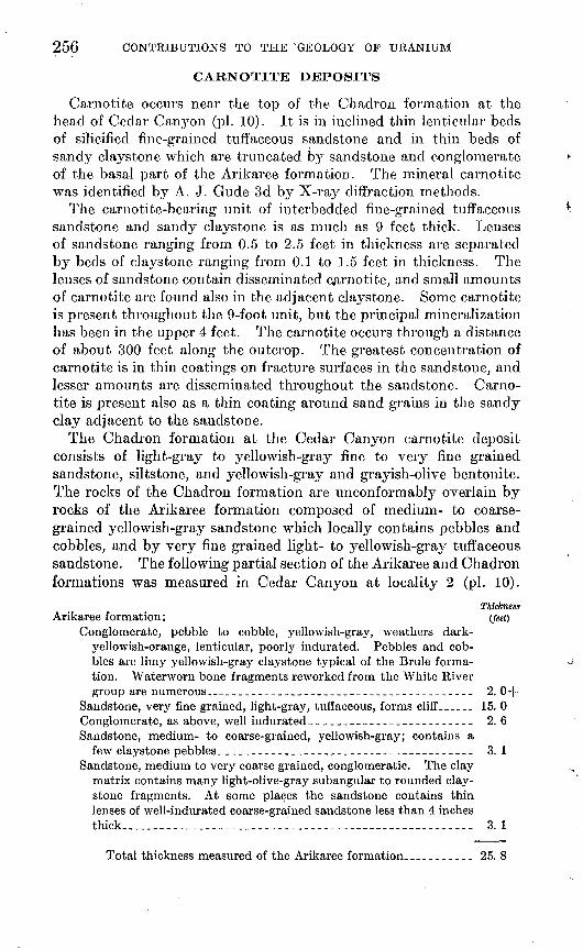
Carnotite occurs near the top of the Chadron formation at the head of Cedar Canyon (pi. 10). It is in inclined thin lenticular beds of silicified fine-grained tuffaceous sandstone and in thin beds of sancty claystone which are truncated by sandstone and conglomerate of the basal part of the Arikaree formation. The mineral carnotite was identified by A. J. Gude 3d by X-ray diffraction methods.
The carnotite-bearing unit of interbedded fine-grained tuffaceous sandstone and sandy claystone is as much as 9 feet thick. Lenses of sandstone ranging from 0.5 to 2.5 feet in thickness are separated by beds of claystone ranging from 0.1 to 1.5 feet in thickness. The lenses of sandstone contain disseminated carnotite, and small amounts of carnotite are found also in the adjacent claj^stone. Some carnotite is present throughout the 9-foot unit, but the principal mineralization has been in the upper 4 feet. The carnotite occurs through a distance of about 300 feet along the outcrop. The greatest concentration of carnotite is in thin coatings on fracture surfaces in the sandstone, and lesser amounts are disseminated throughout the sandstone. Carno tite is present also as a thin coating around sand grains in the sandy clay adjacent to the sandstone.
The Chadron formation at the Cedar Canyon carnotite deposit consists of light-gray to j^ello wish-gray fine to very fine grained sandstone, siltstone, and yellowish-gray and grayish-olive bentonite. The rocks of the Chadron formation are unconformably overlain by rocks of the Arikaree formation composed of medium- to coarse grained yellowish-gray sandstone which locally contains pebbles and cobbles, and by very fine grained light- to yellowish-gray tuffaceous sandstone. The following partial section of the Arikaree and Chadron formations was measured in Cedar Canyon at locality 2 (pi. 10).
Thickness Arikaree formation: (feet)
Conglomerate, pebble to cobble, yellowish-gray, weathers dark- yellowish-orange, lenticular, poorly indurated. Pebbles and cob bles are limy yellowish-gray claystone typical of the Brule forma tion. Waterworn bone fragments reworked from the White River group are numerous_______________________________________ 2. 0+
Sandstone, very fine grained, light-gray, tuffaceous, forms cliff ______ 15. 0Conglomerate, as above, well indurated______________--___-_--._ 2. 6Sandstone, medium- to coarse-grained, yellowish-gray; contains a
few claystone pebbles______-_---___--____-__--_---_----__--_ 3. 1Sandstone, medium to very coarse grained, conglomeratic. The clay
matrix contains many light-olive-gray subangular to rounded clay- stone fragments. At some places the sandstone contains thin lenses of well-indurated coarse-grained sandstone less than 4 inches thick___________________________-__---___--___---- 3. 1
Total thickness measured of the Arikaree formation_________ 25. 8

CARNOTITE-BEARING SANDSTONE IN CEDAR CANYON, S. DAK. 257
ThcknessChadron formation: (feet)
Sandstone, very fine grained, light-gray, silicified; has carnotite coat ing on sand grains____----.---------------------_--.--.-..--- 0. 2
Claystone, sandy, light-gray, soft.-..______________-._._........__ .1Sandstone, as above; contains no visible car notite. _-__---....-,..-_ 1. 2Claystone, as above__-_______---_----_--...---.-.--.....-_---.- 1. 2Sandstone, as above; with carnotite_.. ........................... .7Claystone, as above.____________________-_._--_-._.....---_-..-.- . 1Sandstone, as above; contains no visible carnotite...-.-..-..-__.. .5 Claystone, as above--.--..--.----.---.-.-.-..---..-....-.---.- .5Sandstone, as above; with carnotite-_...-_--._..-.-_.....-..----- .6Claystone, as above... _______ _-________- -_._---.-,--..-.....-- 1.0Sandstone, as above';" contains no visible carnotite- _..-_.-._._.-.. .7 Sandstone, as above, less silicified, poorly indurated, contains carno
tite -_-____-_._.-______.______-___ 7 _--___-__------_----.-.. . 6Sandstone, very fine grained, light-gray, eilicified; has carnotite coat
ing on sand grains._____________'_______________-_--______--_ . 9Claystone, as above_-_----_-__--_-.-- T ------------------------ . 5Sandstone, fine-grained, pale.-rplive; contains many pebbles of very
sandy pale-olive claystone derived from underlying units.__.-_.. 3. 3 Sandstone, very fine grained, pale-olive streaked with dark-yellow-
orange, poorly indurated. Contains a few pebbles of very sandy claystone eroded from underlying unit___._-______._-._______--_ . 6
Bentonite, sandy, pale-olive with a few dark-yellow-orange streaks.- 2. 1 Sandstone, very fine grained, clayey, very light gray, weathers in
fluted columns _ ________________________-________________-'__ 8. 0-f
Total thickness measured of the Chadron formation...________ 22. 8Base of section in ditch north side of road.
Figure 41, an aerial view of Cedar Canyon, illustrates the general topography of the area; and figure 42 shows the stratigraphic relation ship of the carnotite-bearing sandstone in the Chadron formation to the overlying Arikaree formation. The geologic map of the Cedar Canyon area (pi. 10) indicates the areal extent and relation of the various formations to the area of mineralization in the Chadron for mation. Much of the Chadron and Ludlow outcrop is obscured by talus an.dY.R,ecent landslide blocks. Where possible, the attitude of the landslide blocks has been indicated on the map (pi. 10) because the block directly south of the outcrop of mineralized sandstone also contains carnotite.
The mineralized area in this landslide block has a lateral extent of about 100 feet and is as much as 0.8 foot thick.
Analyses of six samples from the Cedar Canyon carnotite deposit are listed in table 1.

258 CONTRIBUTIONS TO THE GEOLOGY OF URANIUM
FIGURE 41. Aerial view of Cedar Canyon, Arrow indicates outcrop of mineralized sandstone.
FIOUEE 42. Stratigraphic relationship of the earnotite-bearing sandstone in the Chudron formation to the overlying Arikaree formation in Cedar Canyon, Slim Buttes area, South Dakota.

CARNOTITE-BEARING SANDSTONE IN CEDAR CANYON, S. DAK. 259
TABLE 1. Analyses of samples collected from the Cedar Canyon carnotite deposit
Local ity no. pi. 10
1
2
3
4
5
6
7
Serial no.
92321
92322
87613
87612
92323
92324
92324a
eU (percent)
0. 036
14
. 13
. . 055
.091
.018
.063
u(percent)
0. 037
. 10
.23
.080
. 19 .
.001
.086
Description
Claystone, sandy, yellowish-gray; contains novisible carnotite. 1-foot channel sample.
Claystone, sandy, yellowish-gray; has carnotite coating on sand grains. 0.3-footchannel sample.
Sandstone, fine-grained, light-gray, silicified;carnotite is concentrated on fracture surfaces. Selected grab sample.
Sandstone, fine-grained, light-gray, silicified;contains disseminated carnotite. Grab
.'" sample.Sandstone, fine-grained, light-gray, silicified;
has carnotite disseminated throughout.Grab sample.
Sandstone, very fine grained, light-gray, silicified; contains no visible carnotite. Grabsample.
Sandstone, fine-grained, light-gray, silicified;contains disseminated carnotite. Grabsample.
A grab sample of carnotite-bearing sandstone (loc. 7) collected from the landslide block, about 300 feet south of the mineralized outcrop, contains 0.086 percent uranium. The mineralized sandstone in this landslide block is similar to that exposed in the outcrop.
Carnotite has been found at two other localities in the southern part of the Slim Buttes, and abnormal radioactivity readings have been obtained at the contact of the White River group and the Arikaree formation throughout the Slim Buttes.
There is a large landslide block at locality 8, in the SW^ sec. 9, T. 16 N., R. 8E. In the Chadron formation, found hi the block, carnotite coats quartz granules in sandstone and sand grains dis seminated in bentonitic clay. Carnotite can be seen in about only 5 feet of outcrop, because of poor exposures in the area. A grab sample of clay, in which there are carnotite-coated sand grains, contains 0.025 percent uranium.
On the south side of Square Top Butte, at locality 9 in the SW% sec. 29, T. 17 N., R. 8 E., carnotite is found as fracture-surface coatings in the basal 0.2 foot of a 1.0 foot opalized clay bed. This opalized clay occurs in the Chadron formation, 19 feet below the contact of the Chadron formation and the Arikaree formation, and is overlain and underlain, by beds of bentonite. Laterally, this opalized clay grades into nonopalized bentonite. Small amounts of carnotite are present for about 100 feet along the outcrop.

260 CONTRIBUTIONS TO THE GEOLOGY OF URANIUM
ORIGIN
The Arikaree formation and formations of the White River group exposed in the Slim Buttes contain large quantities of volcanic glass and altered volcanic material, including bentonite. In the southern part of the Slim Buttes about 250 feet of very fine grained tuffaceous sandstone is present in the Arikaree formation, and an unknown thickness has been removed by erosion. Throughout the Slim Buttes area springs issue from the base of the Arikaree formation, and, at a few places, from the upper few feet of the Chadron formation. These springs result from a water table perched on impervious bentonite and bentonitic sandstone in the upper part of the Chadron formation. Water samples from these springs contain much more uranium than water samples collected from wells and springs in the underlying Fort Union and Hell Creek formations. Water from Summit Spring (sec. 5, T. 16 N., R. 8 E.), issuing from the base of tne Arikaree forma tion, contains 51 parts per billion of uranium; and water from Pnillips Spring (sec. 34, T. 17 N., R. 8 E.), which* fl'ows also from the fyase of the Arikaree formation, contains 170 parts per billion. Water from Section 17 Spring (sec. 17, T. 16 N., R. 9 E.), which issues from the Hell Creek formation, contains only 1 part per billion of uranium. Thirty-four analyses of water from springs and wells within the mapped area (pi. 11 and table 2) show the contrast in uranium content be tween water in the Arikaree and Chadron formations and water in the underlying formations. ^
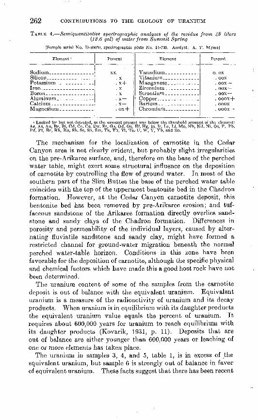
The water from Summit Spring contains 0.42 gram per liter of residue. The residue from 48 liters (12.6 gal) of water from this spring was analyzed chemically and spectrographically. These analyses are tabulated in tables 3 and 4.
Chemical analyses of tuffaceous sandstone from the Arikaree formation indicate that the rock contains about 0.0015 percent uran ium. No vanadium analyses were made, but Davidson (written communication, 1953) reports an average vanadium content of 0.05 percent for 16 samples from the White River group and Arikaree formation in eastern Wyoming.
It is postulated that the uranium, vanadium, silicon, and other elements found concentrated in the Cedar Canyon area as carnotite and silicified sandstone were leached, by moving ground water, from the weakly radioactive volcanic material present in the Arikaree formation. These elements were deposited then in sandstone and claystone along the base of the perched water table, near the top of White River group.

CARNOTITE-BEARING SANDSTONE IN CEDAR CANYON, S. DAK. 261
TABLE 2. Analyses of water samples collected from wells and springs in the southern part of Slim Butles, Harding County, S. Dak.
Road Draw no. 1 Spring.. _____
Rabbit Creek Spring, _______ __
Thybo well -_--_---_ ___Unnamed spring ____ ________Red Tank Spring______ ____ __
Unnamed spring. ___________ _
Do____--__-_________.___Do_ Do____---___-_---__-_--_Do__-__.-_. _____________
Thybo Spring___-.-____. ______
Deer Draw Spring. __ __________Fish Spring_________ ______ _
Unnamed spring _____________Do Do . Do_--_-___-_- ---___-.___
Hines Spring. _ ________ _____Section 17 Spring____________ _Wolf Spring.... ____________ _Unnamed spring. ___ ____.-_ _
Sec.
?525?536?,6?fl303132323432
9,?,33455689
101013131414?41719?03132
Locatio
T. (N.)
17171717171717171717171716161616161616161616161616161616161616161616
11
R. (E.)
7777888888898888888888888888899999
U content
billion)
30224639
52
402741
2. 170.
514
200143210511220155666382413134611
113
245
Do.Do.
Arikaree.Hell Creek. .
Do.Chadron.
Do.Do.
Fort Union.
Fort Union.Chadron.Arikaree.
Do.Do.DoDo.Do.
Chadron.Do.Do.
Do.Do.
Do.Do.
Fort Union.Hell Creek.Arikaree.Chadron.Fort Union.
Do.
TABLE 3. Chemical analyses of metals in the residue from 48 liters (12.6 gal) ofwater from Summit Spring
[Sample serial No. D-86659. Analysts: H. E. Crowe, W. Mountjoy, and P. Schuch]
Element
Vanadium _______________________--__-__----___-.__Uranium __________________________________________Nickel __ _---____-___-_-_-__-____-_-__----- -_.___Copper. ________-__-_____--_____-_---_-__---______-Lead____-__-_____ _____-_-________--__-_--_---_-_-_Molybdenum ______________________________________Cobalt- .
Element in residue
(percent)
0.070.010.0010.0008.0006.0002.0001
Element in water (parts per billion)
290424.23.62.5.8.4
262
TABLE 4. Semi-quantitative spectroyraphic analyses of the residue from J+8 liters (18.6 gal) of water from Summit Spring
[Sample serial No. D-86659, spectrographic plate No. 11-720. Analyst: A. T. Myers]
Element '
Iron..-- __ _ ____ __
Calcium. ___^ _ _ _ _
Percent
x +X
Element
Zirconium ________ _
Barium ________ __
Percent
OOX
ooox
1 Looked for but not detected, as the amount present was below the threshold amount of the element: Ae, As, Au, Be, Bi, Cd, Ce, Co, Dy, Er, Ga, Od, Ge, Hf, Hg, In, Ir, La, Li. Mo, Nb, Nd, Ni, Os, P, Pb, Pd, Pt, Re, Rh, Ru, Sb, Sc, Sn, Sm, Ta, Th, Tl, Te, U, W, Y, Yb, and Zn.
The mechanism for the localization of carnotite in the Cedar Canyon area is not clearly evident, but probably slight irregularities on the pre-Arikaree surface, and, therefore on the base of the perched water table, might exert some structural influence on the deposition of carnotite by controlling the flow of ground water. In most of the southern part of the Slim Buttes the base of the perched water table coincides with the top of the uppermost bentonite bed in the Chadron formation. However, at the Cedar Canyon carnotite deposit, this bentonite bed has been removed by pre-Arikaree erosion; and tuf- faceous sandstone of the Arikaree formation directly overlies sand stone and sandy clays of the Chadron formation. Differences in porosity and permeability of the individual layers, caused by alter nating fluviatile sandstone and sandy clay, might have formed a restricted channel for ground-water migration beneath the normal perched water-table horizon. Conditions in this zone have been favorable for the deposition of carnotite, although the specific physical and chemical factors which have made this a good host rock have not been determined.
The uranium content of some of the samples from the carnotite deposit is out of balance with the equivalent uranium. Equivalent uranium is a measure of the radioactivity of uranium and its decay products. When uranium is in equilibrium with its daughter products the equivalent uranium value equals the percent of uranium. It requires about 600,000 years for uranium to reach equilibrium with its daughter products (Kovarik, 1931, p. 11). Deposits that are out of balance are either younger than 600,000 years or leaching of one or more elements has taken place.
The uranium in samples 3, 4, and 5, table 1, is in excess of the equivalent uranium, but sample 6 is strongly out of balance in favor of equivalent uranium. These facts suggest that there has been recent
CARNOTITE-BEARING SANDSTONE IN CEDAR CANYON, S. DAK. 263
movement and reconcentration of material within the deposit, prob ably as a result of weathering. Perhaps some of the uranium in highly uraniferous spring water is being derived from undiscovered concentrations of uranium much like the deposit at Cedar Canyon.
SUGGESTIONS FOR PROSPECTING
In the southern part of the Slim Buttes occurrences of carnotite are found in sandstone and clay in the upper few feet of the Chadron formation, where it is unconformably overlain by the Arikaree forma tion. In areas where pre-Arikaree slumping has taken place and the Arikaree formation unconformably overlies the Brule formation, abnormally high radioactivity readings are commonly obtained at the contact of these two formations. One such anomaly was recorded at the contact between the Arikaree and Brule formations in the NE#SE#NWtf Sec. 31, T. 17 N., R. 8 E.
Thirty-four analyses of water from springs and wells for uranium are shown on plate 11 and in table 2. Waters from the Arikaree and Chadron formations contain a much greater amount of uranium than waters from the Fort Union and Hell Creek formations. The uranium content of water from springs in the Arikaree and Chadron formations has a considerable range. These ranges in content may be due in part to differences in rates of water flow, as springs of low flow gener ally contain more uranium than springs of high flow. A uranium content of 10 to 20 parts per billion in water is representative for springs issuing from the Arikaree and Chadron formations in the Slim Buttes. A uranium content of 30 or more parts per billion is abnormally high and may indicate the concentration of uranium minerals nearby.
Particular attention should be given to the areas around the following springs:
Uraniumcontent
(parts perbillion) Location
Unnamed spring........ 200 NE^SW^ sec. 2, T. 16 N., R. 8 E.Phillips Spring......... 170 NW^SEJ^ sec. 34, T. 17 N., R. 8 E.Antelope Spring........ 66 SWJ^NEJ^ sec. 10, T. 16 N., R. 8 E.Unnamed spring........ 56 NE^SW^ sec. 9, T. 16 N., R. 8 E.Summit Spring......... 51 SEJ^SE^ sec. 5, T..16., R. 8 E.Unnamed spring..._____ 46 NWMSW^ sec. 14, T. 16 N., R. 8 E.J. B. Spring............ 46 SW^SEM sec. 25, T. 17 N., R. 7 E.Guard Station Spring... 41 SWJ^SW^ sec. 32, T. 17 N., R. 8 E.Unnamed spring........ 40 SWMSEJ4 sec. 30, T. 17 N., R. 8 E.Rabbit Creek Spring.... 39 SE^SE^ sec. 36, T. 17 N., R. 7 E.Rock Spring........... 38 NE^SEM sec. 10, T. 16 N., R. 8 E.
Other favorable areas for the concentration of uranium minerals may be found where the rocks are folded into synclines or where there
264 CONTRIBUTIONS TO THE GEOLOGY OF URANIUM
are sandstone channel deposits. Commonly, silicification of the rocks has accompanied carnotite mineralization. Prospecting should not be restricted to the Arikaree, Brule, and Chadron formations but should include also an investigation of the sandstone beds of the Fort Union and Hell Creek formations, particularly where they are un- conformably overlain by the Arikaree formation and by the White River group.
The recent discovery of uranium-bearing sandstone in the Chadron formation in the White River badlands, Pennington County, S. Dak. (G. W. Moore and Murray Levish, written communication, 1954), suggests that other areas where the Arikaree formation and the White River group are present should be prospected. These units, or their equivalents, crop out in parts of North and South Dakota, Wyoming, Montana, Colorado, Nebraska, and adjacent States.
LITERATURE CITED
Baker, C. L., 1952, Geology of Harding County: S. Dak. Geol. Survey Kept.Inv. 68.
Brown, R. W., 1952, Tertiary strata in eastern Montana and western Northand South Dakota: Billings Geol. Soc. Guidebook, 3d ann. field conference,p. 89-92.
Bump, J. D., 1951, The White River badlands of South Dakota: Soc. of VertebratePaleontology. Guidebook for a field conference (5th), p. 35-46.
Kovarik, A. F., 1931, Calculating the age of minerals from radioactivity data andprincipals: Natl. Research Council Bull. 80, p. 73-123.
MacDonald, J. R., 1951, Additions to the Whitneyan fauna of South Dakota:Jour. Paleontology, v. 25, no. 3, p. 257.
Todd, J. E., 1895, Recent geological work in South Dakota: Am. Geologist, v. 16,p. 303.
Toepelman, W. C., 1923, The possibilities of oil in eastern Harding County, S.Dak.: S. Dak. Geol. and Nat. History Survey Circ. 12.
Winchester, D. E., 1913, Crossbedding in the White River formation of north western South Dakota: Jour. Geology, v. 21, p. 550-556.
Winchester, D. E., Hares, C. J., Lloyd, E. R., and Parks, E. N., 1916, The lignitefield of northwestern South Dakota: U. S. Geol. Survey Bull. 627.
Wood, H. E. 2d, 1945, Late Miocene beaver from southeastern Montana: Am.Mus. Novitates 1299.
U. S. GOVERNMENT PRINTING OFFICE: 1955