case history library of shrub steppe and grassland ... · pdf filecase history library of...
TRANSCRIPT
1
Case History Library of Shrub Steppe and Grassland Restoration
Projects in the Columbia River Basin
10/18/2011
This case history library is a companion document to the Shrub Steppe and Grassland Restoration
Manual For the Columbia River Basin (http://wdfw.wa.gov/publications/01330). Interviews with
pioneering restoration specialists during the creation of the manual indicated that many lessons were
independently learned via the slow, expensive, frustrating process of trial and error. Interviews also
indicated that documenting and sharing project information would be a powerful means of accelerating
the science and art of restoration. The manual includes a Restoration Project Documentation Form that
was created so managers can conveniently and uniformly record planning and implementation activities
as they occur and then share details about projects. The template provides for narratives, summary
tables, monitoring data, photographs, and attaching of ancillary documents to create a comprehensive
case history that can be shared with others who might be assigned in mid-project, colleagues, funding
institutions, and other interested parties. While the template asks for standard information to allow for
meaningful comparisons of projects, there is no limit on what information goes into the case histories.
It is important to note that case histories need not be fully completed to be of value. Partially
completed case histories can also serve as the basis for initial funding requests, progress reports and
applications for continuing financial support. In fact, case histories are never really done. The
evaluation of current conditions section can be repeatedly completed at different post-project time
intervals to track the trajectory of a site.
This case history library currently contains ten case histories for projects of different ages representing a
variety of restoration project scenarios. The case history examples herein were created after-the-fact
based on notes or memory of the project staff. Accordingly, the case histories are not necessarily the
best examples of project documentation. Naturally, the case histories would be more detailed if the
template existed before the projects started and managers had foreknowledge that details about their
projects would one day be openly shared. Nevertheless, these case histories provide details about a
variety of challenging projects that have never been recorded for distribution. It should be noted that
the case histories were not selected to only represent the most successful projects. Rather, the case
histories were selected to provide a description of a variety of situations, outcomes and lessons learned.
In some case histories, project managers point out mistakes, unexplained failures, or unanticipated
successes to help others learn from their experiences. The project managers deserve respect for their
candor.
Going forward project managers should be able to produce more detailed case histories with little extra
effort. Two versions of Restoration Project Documentation Form can be downloaded with and without
embedded instructions.

2
All of the intermediate work products that the manual suggests that people create throughout a project
like the seed mix, or monitoring report forms can be directly inserted into the Restoration Project
Documentation Form to gradually create a complete case history.
The form should be used as the project progresses, starting with the earliest phases of planning.
Instructions within the form should be deleted after they are no longer needed. When documentation
proceeds as the project progresses, it is easy to include details that are otherwise soon forgotten or later
require more effort to retrieve.
Going forward, WDFW, BLM, and others can add to this case history library by submitting case histories
to Richard Tveten at [email protected] . If all future projects contributed to a shared case
history library, project proponents could quickly gain insights learned from recent, similar projects and
apply them to their projects. Likewise, the information could be used to prioritize research and update
the manual.
3
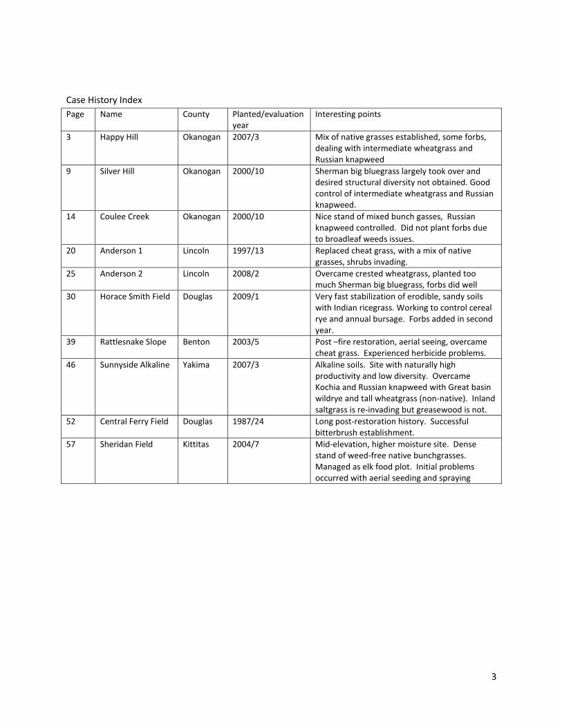
Case History Index
Page Name County Planted/evaluation year
Interesting points
3 Happy Hill Okanogan 2007/3 Mix of native grasses established, some forbs, dealing with intermediate wheatgrass and Russian knapweed
9 Silver Hill Okanogan 2000/10 Sherman big bluegrass largely took over and desired structural diversity not obtained. Good control of intermediate wheatgrass and Russian knapweed.
14 Coulee Creek Okanogan 2000/10 Nice stand of mixed bunch gasses, Russian knapweed controlled. Did not plant forbs due to broadleaf weeds issues.
20 Anderson 1 Lincoln 1997/13 Replaced cheat grass, with a mix of native grasses, shrubs invading.
25 Anderson 2 Lincoln 2008/2 Overcame crested wheatgrass, planted too much Sherman big bluegrass, forbs did well
30 Horace Smith Field Douglas 2009/1 Very fast stabilization of erodible, sandy soils with Indian ricegrass. Working to control cereal rye and annual bursage. Forbs added in second year.
39 Rattlesnake Slope Benton 2003/5 Post –fire restoration, aerial seeing, overcame cheat grass. Experienced herbicide problems.
46 Sunnyside Alkaline Yakima 2007/3 Alkaline soils. Site with naturally high productivity and low diversity. Overcame Kochia and Russian knapweed with Great basin wildrye and tall wheatgrass (non-native). Inland saltgrass is re-invading but greasewood is not.
52 Central Ferry Field Douglas 1987/24 Long post-restoration history. Successful bitterbrush establishment.
57 Sheridan Field Kittitas 2004/7 Mid-elevation, higher moisture site. Dense stand of weed-free native bunchgrasses. Managed as elk food plot. Initial problems occurred with aerial seeding and spraying
4
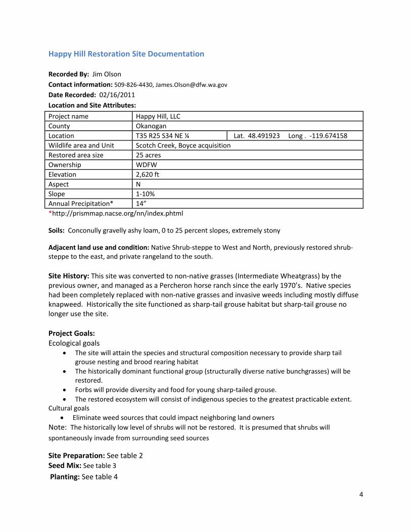
Happy Hill Restoration Site Documentation
Recorded By: Jim Olson
Contact information: 509-826-4430, [email protected]
Date Recorded: 02/16/2011
Location and Site Attributes:
Project name Happy Hill, LLC
County Okanogan
Location T35 R25 S34 NE ¼ Lat. 48.491923 Long . -119.674158
Wildlife area and Unit Scotch Creek, Boyce acquisition
Restored area size 25 acres
Ownership WDFW
Elevation 2,620 ft
Aspect N
Slope 1-10%
Annual Precipitation* 14”
*http://prismmap.nacse.org/nn/index.phtml
Soils: Conconully gravelly ashy loam, 0 to 25 percent slopes, extremely stony
Adjacent land use and condition: Native Shrub-steppe to West and North, previously restored shrub-steppe to the east, and private rangeland to the south.
Site History: This site was converted to non-native grasses (Intermediate Wheatgrass) by the previous owner, and managed as a Percheron horse ranch since the early 1970’s. Native species had been completely replaced with non-native grasses and invasive weeds including mostly diffuse knapweed. Historically the site functioned as sharp-tail grouse habitat but sharp-tail grouse no longer use the site.
Project Goals: Ecological goals
The site will attain the species and structural composition necessary to provide sharp tail grouse nesting and brood rearing habitat
The historically dominant functional group (structurally diverse native bunchgrasses) will be restored.
Forbs will provide diversity and food for young sharp-tailed grouse.
The restored ecosystem will consist of indigenous species to the greatest practicable extent. Cultural goals
Eliminate weed sources that could impact neighboring land owners
Note: The historically low level of shrubs will not be restored. It is presumed that shrubs will
spontaneously invade from surrounding seed sources
Site Preparation: See table 2
Seed Mix: See table 3
Planting: See table 4
5
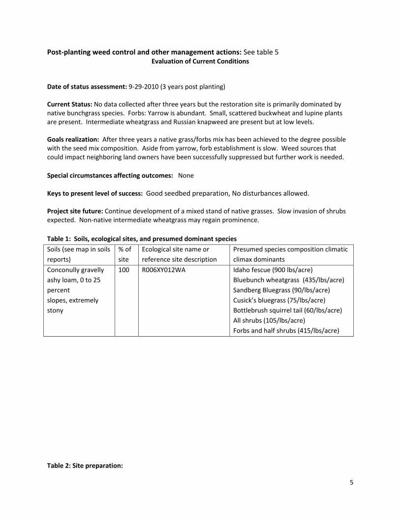
Post-planting weed control and other management actions: See table 5 Evaluation of Current Conditions
Date of status assessment: 9-29-2010 (3 years post planting) Current Status: No data collected after three years but the restoration site is primarily dominated by native bunchgrass species. Forbs: Yarrow is abundant. Small, scattered buckwheat and lupine plants are present. Intermediate wheatgrass and Russian knapweed are present but at low levels. Goals realization: After three years a native grass/forbs mix has been achieved to the degree possible with the seed mix composition. Aside from yarrow, forb establishment is slow. Weed sources that could impact neighboring land owners have been successfully suppressed but further work is needed.
Special circumstances affecting outcomes: None
Keys to present level of success: Good seedbed preparation, No disturbances allowed. Project site future: Continue development of a mixed stand of native grasses. Slow invasion of shrubs expected. Non-native intermediate wheatgrass may regain prominence.
Table 1: Soils, ecological sites, and presumed dominant species
Soils (see map in soils
reports)
% of
site
Ecological site name or
reference site description
Presumed species composition climatic
climax dominants
Conconully gravelly
ashy loam, 0 to 25
percent
slopes, extremely
stony
100 R006XY012WA Idaho fescue (900 lbs/acre)
Bluebunch wheatgrass (435/lbs/acre)
Sandberg Bluegrass (90/lbs/acre)
Cusick’s bluegrass (75/lbs/acre)
Bottlebrush squirrel tail (60/lbs/acre)
All shrubs (105/lbs/acre)
Forbs and half shrubs (415/lbs/acre)
Table 2: Site preparation:
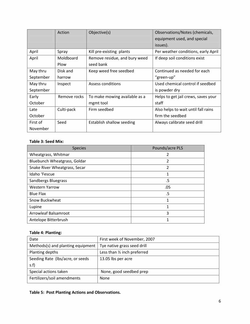
6
Action
Objective(s)
Observations/Notes (chemicals,
equipment used, and special
issues).
April Spray Kill pre-existing plants Per weather conditions, early April
April Moldboard
Plow
Remove residue, and bury weed
seed bank
If deep soil conditions exist
May thru
September
Disk and
harrow
Keep weed free seedbed Continued as needed for each
“green-up”
May thru
September
Inspect Assess conditions Used chemical control if seedbed
is powder dry
Early
October
Remove rocks To make mowing available as a
mgmt tool
Helps to get jail crews, saves your
staff
Late
October
Culti-pack Firm seedbed Also helps to wait until fall rains
firm the seedbed
First of
November
Seed Establish shallow seeding Always calibrate seed drill
Table 3: Seed Mix:
Species Pounds/acre PLS
Wheatgrass, Whitmar 2
Bluebunch Wheatgrass, Goldar 2
Snake River Wheatgrass, Secar 2
Idaho ‘Fescue 1
Sandbergs Bluegrass .5
Western Yarrow .05
Blue Flax .5
Snow Buckwheat 1
Lupine 1
Arrowleaf Balsamroot 3
Antelope Bitterbrush 1
Table 4: Planting:
Date First week of November, 2007
Methods(s) and planting equipment Tye native grass seed drill
Planting depths Less than ½ inch preferred
Seeding Rate (lbs/acre, or seeds
s.f)
13.05 lbs per acre
Special actions taken None, good seedbed prep
Fertilizers/soil amendments None
Table 5: Post Planting Actions and Observations.
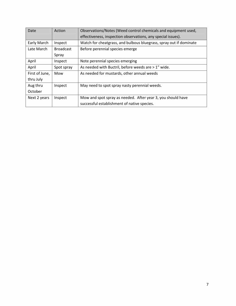
7
Date Action
Observations/Notes (Weed control chemicals and equipment used,
effectiveness, inspection observations, any special issues).
Early March Inspect Watch for cheatgrass, and bulbous bluegrass, spray out if dominate
Late March Broadcast
Spray
Before perennial species emerge
April Inspect Note perennial species emerging
April Spot spray As needed with Buctril, before weeds are > 1” wide.
First of June,
thru July
Mow As needed for mustards, other annual weeds
Aug thru
October
Inspect May need to spot spray nasty perennial weeds.
Next 2 years Inspect Mow and spot spray as needed. After year 3, you should have
successful establishment of native species.
8
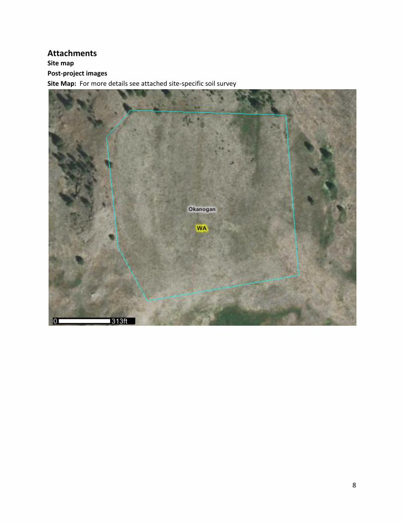
Attachments Site map
Post-project images
Site Map: For more details see attached site-specific soil survey
9
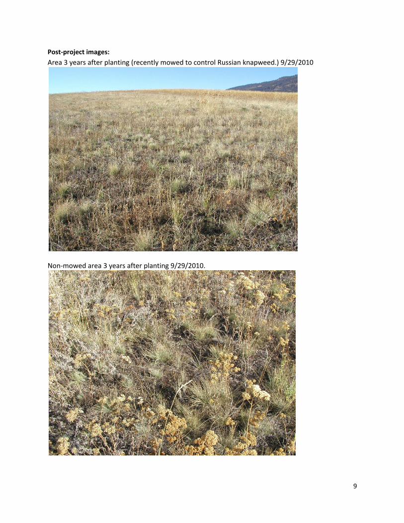
Post-project images:
Area 3 years after planting (recently mowed to control Russian knapweed.) 9/29/2010
Non-mowed area 3 years after planting 9/29/2010.
10
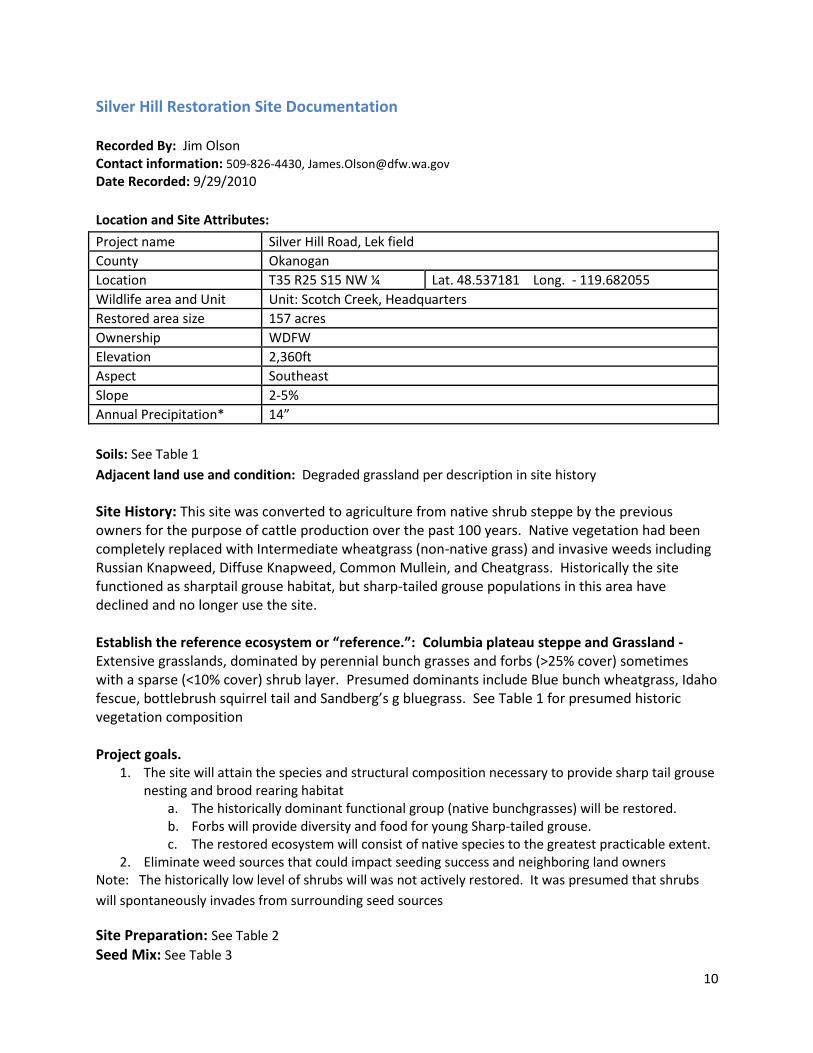
Silver Hill Restoration Site Documentation
Recorded By: Jim Olson Contact information: 509-826-4430, [email protected] Date Recorded: 9/29/2010
Location and Site Attributes:
Project name Silver Hill Road, Lek field
County Okanogan
Location T35 R25 S15 NW ¼ Lat. 48.537181 Long. - 119.682055
Wildlife area and Unit Unit: Scotch Creek, Headquarters
Restored area size 157 acres
Ownership WDFW
Elevation 2,360ft
Aspect Southeast
Slope 2-5%
Annual Precipitation* 14”
Soils: See Table 1
Adjacent land use and condition: Degraded grassland per description in site history
Site History: This site was converted to agriculture from native shrub steppe by the previous owners for the purpose of cattle production over the past 100 years. Native vegetation had been completely replaced with Intermediate wheatgrass (non-native grass) and invasive weeds including Russian Knapweed, Diffuse Knapweed, Common Mullein, and Cheatgrass. Historically the site functioned as sharptail grouse habitat, but sharp-tailed grouse populations in this area have declined and no longer use the site. Establish the reference ecosystem or “reference.”: Columbia plateau steppe and Grassland - Extensive grasslands, dominated by perennial bunch grasses and forbs (>25% cover) sometimes with a sparse (<10% cover) shrub layer. Presumed dominants include Blue bunch wheatgrass, Idaho fescue, bottlebrush squirrel tail and Sandberg’s g bluegrass. See Table 1 for presumed historic vegetation composition Project goals.
1. The site will attain the species and structural composition necessary to provide sharp tail grouse nesting and brood rearing habitat
a. The historically dominant functional group (native bunchgrasses) will be restored. b. Forbs will provide diversity and food for young Sharp-tailed grouse. c. The restored ecosystem will consist of native species to the greatest practicable extent.
2. Eliminate weed sources that could impact seeding success and neighboring land owners Note: The historically low level of shrubs will was not actively restored. It was presumed that shrubs
will spontaneously invades from surrounding seed sources
Site Preparation: See Table 2
Seed Mix: See Table 3
11
Planting: See Table 4
Post-planting weed control and other management actions: See Table 5
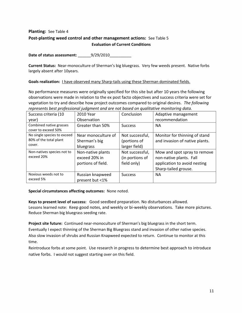
Evaluation of Current Conditions Date of status assessment: ______9/29/2010__________ Current Status: Near-monoculture of Sherman’s big bluegrass. Very few weeds present. Native forbs largely absent after 10years. Goals realization: I have observed many Sharp-tails using these Sherman dominated fields.
No performance measures were originally specified for this site but after 10 years the following observations were made in relation to the ex post facto objectives and success criteria were set for vegetation to try and describe how project outcomes compared to original desires. The following represents best professional judgment and are not based on qualitative monitoring data.
Success criteria (10 year)
2010 Year Observation
Conclusion Adaptive management recommendation
Combined native grasses cover to exceed 50%
Greater than 50% Success NA
No single species to exceed 80% of the total plant cover.
Near monoculture of Sherman’s big bluegrass
Not successful, (portions of larger field)
Monitor for thinning of stand and invasion of native plants.
Non-natives species not to exceed 20%
Non-native plants exceed 20% in portions of field.
Not successful, (in portions of field only)
Mow and spot spray to remove non-native plants. Fall application to avoid nesting Sharp-tailed grouse.
Noxious weeds not to exceed 5%
Russian knapweed present but <1%
Success NA
Special circumstances affecting outcomes: None noted.
Keys to present level of success: Good seedbed preparation. No disturbances allowed. Lessons learned note: Keep good notes, and weekly or bi-weekly observations. Take more pictures. Reduce Sherman big bluegrass seeding rate. Project site future: Continued near-monoculture of Sherman’s big bluegrass in the short term.
Eventually I expect thinning of the Sherman Big Bluegrass stand and invasion of other native species.
Also slow invasion of shrubs and Russian Knapweed expected to return. Continue to monitor at this
time.
Reintroduce forbs at some point. Use research in progress to determine best approach to introduce
native forbs. I would not suggest starting over on this field.
12
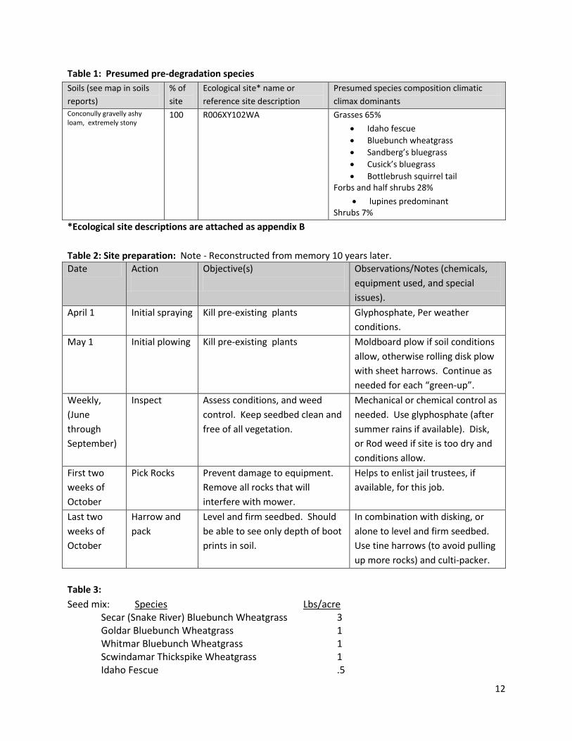
Table 1: Presumed pre-degradation species
Soils (see map in soils
reports)
% of
site
Ecological site* name or
reference site description
Presumed species composition climatic
climax dominants
Conconully gravelly ashy loam, extremely stony
100 R006XY102WA Grasses 65%
Idaho fescue
Bluebunch wheatgrass
Sandberg’s bluegrass
Cusick’s bluegrass
Bottlebrush squirrel tail Forbs and half shrubs 28%
lupines predominant Shrubs 7%
*Ecological site descriptions are attached as appendix B
Table 2: Site preparation: Note - Reconstructed from memory 10 years later.
Date Action
Objective(s)
Observations/Notes (chemicals,
equipment used, and special
issues).
April 1 Initial spraying Kill pre-existing plants Glyphosphate, Per weather
conditions.
May 1 Initial plowing Kill pre-existing plants Moldboard plow if soil conditions
allow, otherwise rolling disk plow
with sheet harrows. Continue as
needed for each “green-up”.
Weekly,
(June
through
September)
Inspect Assess conditions, and weed
control. Keep seedbed clean and
free of all vegetation.
Mechanical or chemical control as
needed. Use glyphosphate (after
summer rains if available). Disk,
or Rod weed if site is too dry and
conditions allow.
First two
weeks of
October
Pick Rocks Prevent damage to equipment.
Remove all rocks that will
interfere with mower.
Helps to enlist jail trustees, if
available, for this job.
Last two
weeks of
October
Harrow and
pack
Level and firm seedbed. Should
be able to see only depth of boot
prints in soil.
In combination with disking, or
alone to level and firm seedbed.
Use tine harrows (to avoid pulling
up more rocks) and culti-packer.
Table 3:
Seed mix: Species Lbs/acre Secar (Snake River) Bluebunch Wheatgrass 3 Goldar Bluebunch Wheatgrass 1 Whitmar Bluebunch Wheatgrass 1 Scwindamar Thickspike Wheatgrass 1 Idaho Fescue .5
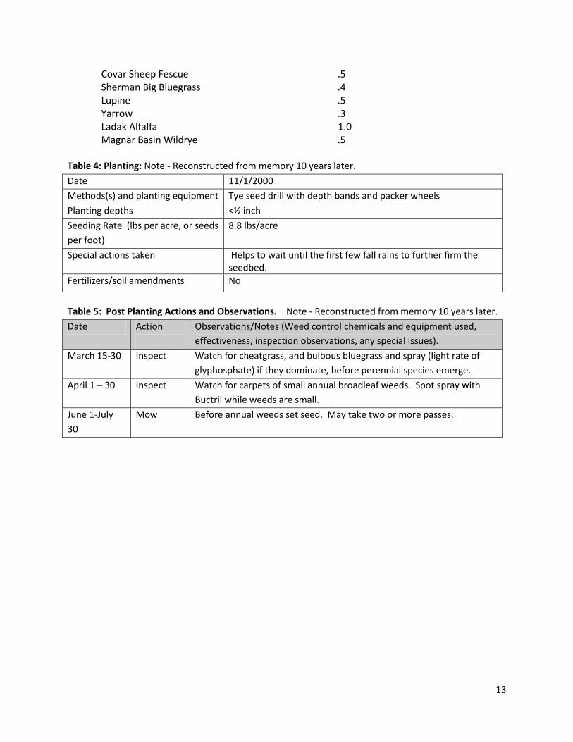
13
Covar Sheep Fescue .5 Sherman Big Bluegrass .4 Lupine .5 Yarrow .3 Ladak Alfalfa 1.0
Magnar Basin Wildrye .5 Table 4: Planting: Note - Reconstructed from memory 10 years later.
Date 11/1/2000
Methods(s) and planting equipment Tye seed drill with depth bands and packer wheels
Planting depths <½ inch
Seeding Rate (lbs per acre, or seeds
per foot)
8.8 lbs/acre
Special actions taken Helps to wait until the first few fall rains to further firm the seedbed.
Fertilizers/soil amendments No
Table 5: Post Planting Actions and Observations. Note - Reconstructed from memory 10 years later.
Date Action
Observations/Notes (Weed control chemicals and equipment used,
effectiveness, inspection observations, any special issues).
March 15-30 Inspect Watch for cheatgrass, and bulbous bluegrass and spray (light rate of
glyphosphate) if they dominate, before perennial species emerge.
April 1 – 30 Inspect Watch for carpets of small annual broadleaf weeds. Spot spray with
Buctril while weeds are small.
June 1-July
30
Mow Before annual weeds set seed. May take two or more passes.
14
Attachments
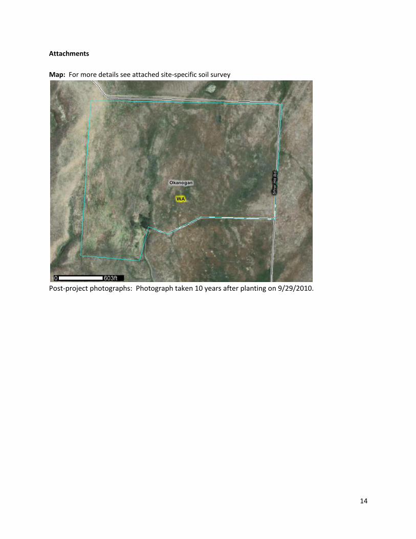
Map: For more details see attached site-specific soil survey
Post-project photographs: Photograph taken 10 years after planting on 9/29/2010.
15
Coulee Creek Restoration Site Documentation
-
Recorded By: Jim Olson Contact information: 509-826-4430, [email protected] Date Recorded: 9/29/2010 Location and Site Attributes:
Project name Coulee Creek Field west of Alfalfa
County Okanogan
Location T35 R25 S23 NW ¼ Lat. 48.52047 Long. -119.660168
Wildlife area and Unit Unit: Scotch Creek, Coulee Creek Drainage
Restored area size 62 acres
Ownership WDFW
Elevation 1,700ft
Aspect East
Slope 2-5%
Annual Precipitation 14”
Soils: See Table 1.
Adjacent land use and condition: Alfalfa field adjacent to east possible weed source.
Site History: This site was converted to agriculture by the previous owners for the purpose of cattle production over the past 100 years. Native species had been completely replaced with non-native grasses and invasive weeds including Russian knapweed. Historically the site functioned as sharptail grouse habitat but sharptail grouse no longer use the site. Presumed historic condition is Columbia plateau steppe and Grassland: Extensive grasslands, dominated by perennial bunch grasses and forbs (>25% cover) sometimes with a sparse (<10% cover) shrub layer. Presumed dominants include Blue bunch wheatgrass, Idaho fescue, bottlebrush squirrel tail and Sandberg’s bluegrass.
Project Goals:
3. The site will attain the species and structural composition necessary to provide sharp tail grouse nesting and brood rearing habitat
a. The historically dominant functional group (native bunchgrasses) will be restored. b. Forbs will provide diversity and food for young Sharp-tailed grouse. c. The restored ecosystem will consist of indigenous species to the greatest practicable
extent. 4. Eliminate weed sources that could impact seeding success and neighboring land owners
Note: The historically low level of shrubs will was not actively restored. It was presumed that
shrubs will spontaneously invades from surrounding seed sources
16
Ex post facto 10-year performance standards
Combined native grass cover to exceed 80%
No single species to exceed 80% of the total plant cover
Non-natives species cover not to exceed 20% cover
Noxious weeds not to exceed 5% cover
Site Preparation: See Table 2
Seed Mix: See Table 3
Planting: See Table 4
Post-planting weed control and other management actions: See Table 5
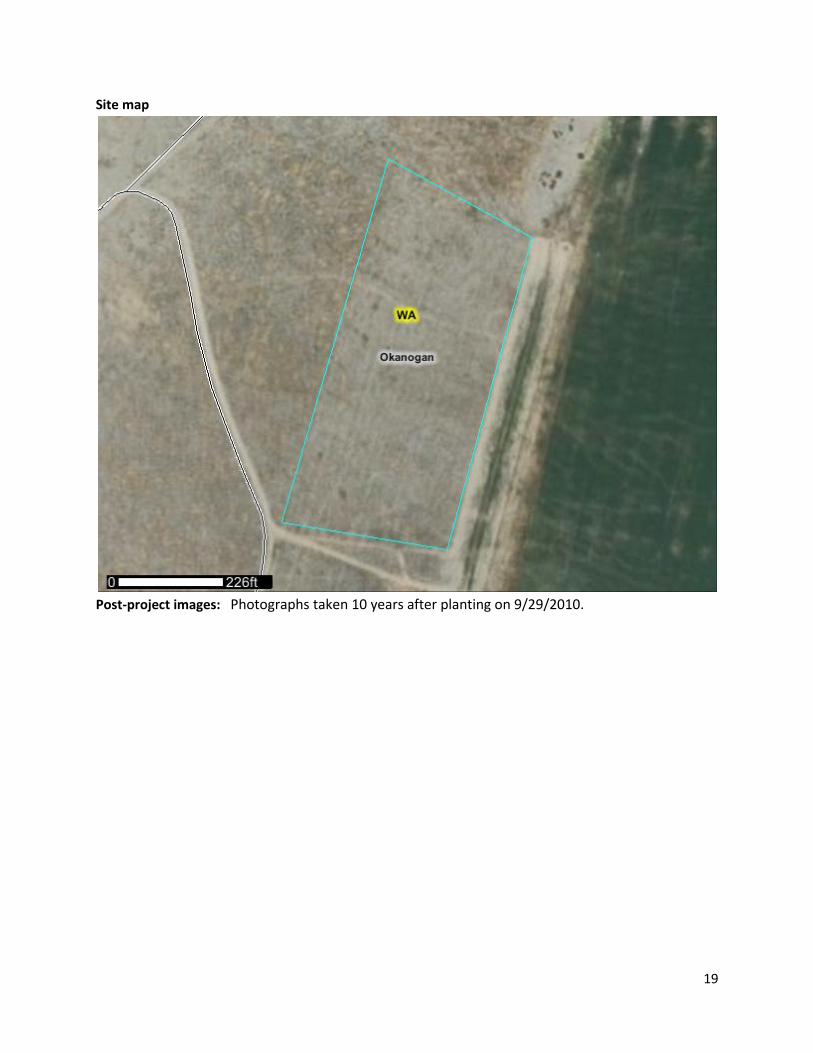
Evaluation of Current Conditions Date of status assessment: ______9/29/2010__(10 years post planting________ Current Status: No data collected but the restoration site is dominated by the planted native bunchgrass species. Non-native plants are a minor component and noxious weed cover is very low. Native forbs are largely not present.
Goals realization: No performance measures were originally specified for this site but after 10
years the following observations were made in relation to the ex post facto success criteria. The
following represents best professional judgment and are not based on qualitative monitoring
data. See photographs. The site has some qualities of good sharptail grouse habitat.
Success criteria (10
year)
10 Year Observation Conclusion Adaptive management
recommendation
Combined native grasses
cover to exceed 50%
Far greater than 50% Success NA
No single species to
exceed 80% of the total
plant cover.
There is a relatively
even mix of the three
native grasses
Success NA
Non-natives species not
to exceed 20%
Non-native plants
present but well
under 20%
Success NA
Noxious weeds not to
exceed 5%
Russian knapweed
present but <1%
Success Spot spray in November
Note: No specific criteria for forbs in light of broadleaf weed control concerns. . Special circumstances affecting outcomes: None noted.
17
Keys to present level of success: Good seedbed preparation. No disturbances allowed. Project site future: Continue of mixed stand of native grasses. Slow invasion of shrubs expected. Slow
invasion of Russian Knapweed to return unless controlled. Native forbs not returning after 10 years.
Reintroduce forbs at some point. Use research in progress to determine best approach to introduce
native forbs.
Table 1: Soils, ecological sites, and presumed dominant species
Soils (see map in soils
reports)
% of
site
Ecological site* name or
reference site description
Presumed species composition climatic
climax dominants
Conconully gravelly
ashy loam, 0 to 25
percent
slopes, extremely
stony
100 R006XY201WA Bluebunch wheatgrass 25%
Idaho fescue 24%
Sandberg Bluegrass 16%
Bottlebrush squirrel tail 11%
Forbs and half shrubs 35%
See Site Specific Soil Report and Ecological Site Description as Appendices.
Table 2: Site preparation: Note - Reconstructed from memory 10 years later.
Date Action
Objective(s)
Observations/Notes (chemicals,
equipment used, and special
issues).
4/2000 Spray Kill pre-existing plants Per weather conditions
5/2000 Plow Kill pre-existing plants Continued as needed for each
“green-up”
Weekly Inspect Assess conditions Used chemical control if seedbed
is powder dry
Season Harrow Reduce seedbed If needed
Table 3: Seed Mix:
Species Lbs/acre Secar Bluebunch Wheatgrass 3 Goldar Bluebunch Wheatgrass 1 Whitmar Bluebunch Wheatgrass 1 Scwindamar Thickspike Wheatgrass 1 Idaho Fescue .5 Covar Sheep Fescue .5 Sherman Big Bluegrass .4 Lupine .5 Yarrow .3 Ladak Alfalfa 1
Magnar Basin Wildrye .5
18
Table 4: Planting: Note - Reconstructed from memory 10 years later.
Date 11/1/2000
Methods(s) and planting equipment Tye seed drill
Planting depths ½ inch
Seeding Rate (lbs per acre, or seeds
per foot)
8.8 lbs/acre
Special actions taken No
Fertilizers/soil amendments No
Table 5: Post Planting Actions and Observations. Note - Reconstructed from memory 10 years later.
Date Action
Observations/Notes (Weed control chemicals and equipment used,
effectiveness, inspection observations, any special issues).
3/15-30/2001 Inspect Assess conditions
3/15-30/2001 Broadcast
spray
Kill bulbous and cheat grass before perennial species emerge.
4/15-30/2001 Inspect Assess conditions
5/2001 Spot spray Kill “carpets” of competing veg.
Weekly
remainder of
season
Inspect Assess conditions
July/July/01 Mow Reduce competition, stop seed set As needed for mustards, and other
annual weeds
Attachments
Site map
Post-project photographs
19
Site map
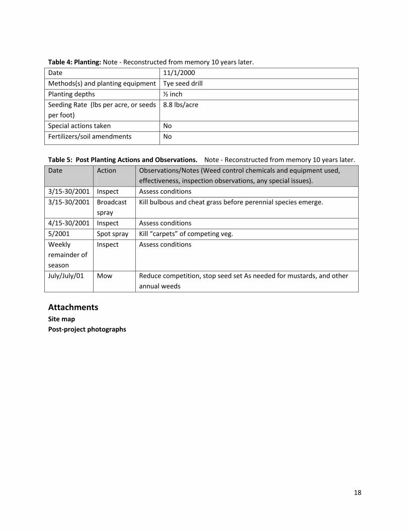
Post-project images: Photographs taken 10 years after planting on 9/29/2010.
20
Post-project photographs (10 years after planting)
21
Anderson 1 Restoration Site Documentation
Recorded By: Mike C Finch
Contact information: 509-636-2344 [email protected]
Date Recorded: 01/27/2011
Location and Site Attributes:
Project name Anderson 1
County Lincoln
Location T24 R35 S23 N ½ S14 S ½ Lat. 47.556 Long. -118.366
Wildlife area and Unit Swanson Lakes Wildlife Area
Restored area size 110 acres
Ownership WDFW
Elevation 2,280 ft
Aspect S
Slope 2-5%
Annual Precipitation* 14”
*http://prismmap.nacse.org/nn/index.phtml
Soils: Bagdad Silt loam and Endicott Silt loam
Adjacent land use and condition: Agriculture cereal grain fields that border to the north and east side. Shrub- steppe and range land to the west and alfalfa pasture to the south.
Site History: Prior to 1997 this field was used for cereal grain production only. We converted this field the last year after the crop was harvested into a native grass/forbs mix. This was a problem site for cheat grass due to the crop rotation history. Project Goals: Establish a predominantly native grass/forbs mix to aid with grouse recovery and to compete with weeds or other non-native plant species. Eliminate weed sources that could impact seeding success and adjacent landowners that raise cereal grains. Note: The 1997 seed mix included non-native species because of budget reason. We were able to get more bang for our buck by including some non-natives Site Preparation: See table 2
Seed Mix: See table 3
Planting: See table 4
Post-planting weed control and other management actions: See table 5
22
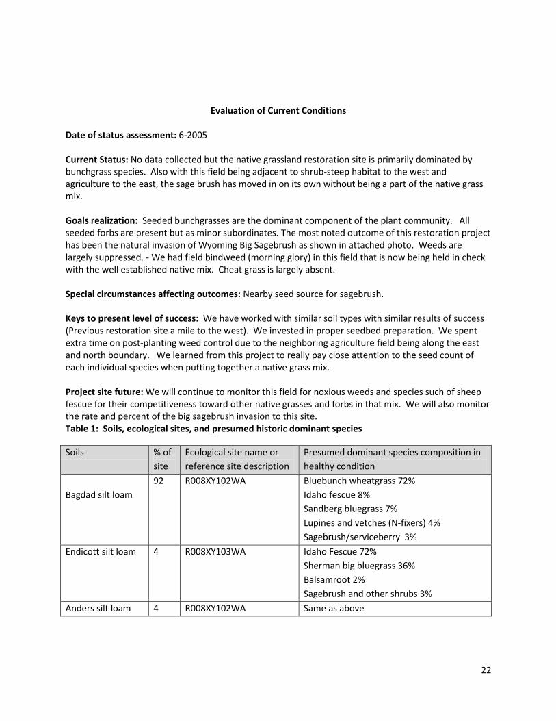
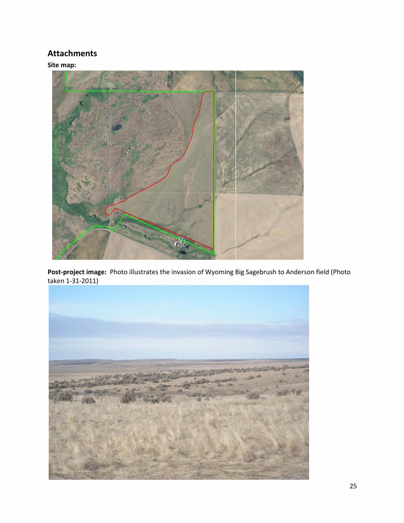
Evaluation of Current Conditions Date of status assessment: 6-2005 Current Status: No data collected but the native grassland restoration site is primarily dominated by bunchgrass species. Also with this field being adjacent to shrub-steep habitat to the west and agriculture to the east, the sage brush has moved in on its own without being a part of the native grass mix. Goals realization: Seeded bunchgrasses are the dominant component of the plant community. All seeded forbs are present but as minor subordinates. The most noted outcome of this restoration project has been the natural invasion of Wyoming Big Sagebrush as shown in attached photo. Weeds are largely suppressed. - We had field bindweed (morning glory) in this field that is now being held in check with the well established native mix. Cheat grass is largely absent. Special circumstances affecting outcomes: Nearby seed source for sagebrush. Keys to present level of success: We have worked with similar soil types with similar results of success (Previous restoration site a mile to the west). We invested in proper seedbed preparation. We spent extra time on post-planting weed control due to the neighboring agriculture field being along the east and north boundary. We learned from this project to really pay close attention to the seed count of each individual species when putting together a native grass mix. Project site future: We will continue to monitor this field for noxious weeds and species such of sheep fescue for their competitiveness toward other native grasses and forbs in that mix. We will also monitor the rate and percent of the big sagebrush invasion to this site. Table 1: Soils, ecological sites, and presumed historic dominant species
Soils % of
site
Ecological site name or
reference site description
Presumed dominant species composition in
healthy condition
Bagdad silt loam
92 R008XY102WA Bluebunch wheatgrass 72%
Idaho fescue 8%
Sandberg bluegrass 7%
Lupines and vetches (N-fixers) 4%
Sagebrush/serviceberry 3%
Endicott silt loam 4 R008XY103WA Idaho Fescue 72%
Sherman big bluegrass 36%
Balsamroot 2%
Sagebrush and other shrubs 3%
Anders silt loam 4 R008XY102WA Same as above
23
Table 2: Site preparation:
Date
Action
Objective(s)
Observations/Notes (chemicals,
equipment used, and special
issues).
4-1997
Harrow winter
wheat stubble
Breakup and thin stubble residue 75 ft tine harrow; waited for
stubble to be nice and dry
5-1997 Cultivate First main tillage operation to
reduce residue
15 ft cultivator sweep
6-1997 Cultiweeder/
harrow
Used cultiweeder machine, 1
machine, both cultivator and rod
weeder/harrow- clean field from
all weeds
30 ft machine used to clean field
from all weeds and help reduce
residue
7-1997 Cultiweeder/
harrow
Clean field from all weeds 30 ft machine used to clean field
from all weeds and help reduce
residue
8-1997 Cultiweeder/
harrow
Clean field from all weeds 30 ft machine used to clean field
from all weeds and help reduce
residue
Table 3: Seed Mix:
Species Percent Seeds/s.f. Pure live seeds lbs/acre
Big bluegrass, Sherman 17.0% 41.3 1.82 lbs/ac
Sheep fescue, Covar 17.0% 31.8 1.56 lbs/ac
Thick-spike wheatgrass 17.0% 7.2 1.86 lbs/ac
Idaho Fescue 6.3% 7.43 .62 lbs/ac
Burnet, Delar 12.7% 1.79 1.52 lbs/ac
Alfalfa, Ladak 8.5% 5.20 1.00 lbs/ac
Lupine, silky 4.2% .143 .40 lbs/ac
Sainfoin, Remont 17.0% 1.40 1.00lbs/ac
Rice hulls 15.0% N/A N/A
Table 4: Planting:
Date 11-6-1997
Methods(s) and planting equipment 24 ft double disc Tye drill/ press wheels
Planting depths 1/8”
Seeding Rate (lbs/acre, or
seeds/s.f.)
12 lbs/ac of grasses and forbs/ rice hulls as filler in addition
Special actions taken We made sure that we had a nice firm seedbed for planting
Fertilizers/soil amendments None
24
Table 5: Post Planting Actions and Observations.
Date Action
Observations/Notes (Weed control chemicals and equipment used,
effectiveness, inspection observations, any special issues).
4-1998 Inspect field New grasses forbs and weeds for new emergence
5-1998 Post spray 1 ½ pt/acre of Buctril (Bromoxynil)with no surfactant; weak on purple
mustard and only effects broadleaf weeds. Grasses must be in 2-3 leaf
stage with mustards no larger than 2-3” diameter.
7-1998 Mow Mowed second flush and re-growth of weeds. Mowing will help
stimulates new and established grasses for a healthier plant
8-1998 Mow Mowed just areas of weed infestation
9-1998 Inspect field Important to inspect the field on a regular schedule
5-1999 Inspect field Noticed a high plant population of Sherman big bluegrass
6-2000 Inspect field After looking at the native grass establishment it was noted that the
high plant count of Sherman was due to not considering the high
number of seeds/lb (882,000) of that particular species and what
percent of the mix we had of Sherman (.17%). The exact same
conclusion came from the Sheep fescue in the mix (680,000) seeds/lb
with it being .17% of the total mix and not knowing the high
competitiveness of that particular species. Since then we no longer use
Sheep fescue and we greatly reduced the percent of Sherman used on
any restoration field due to the high number of seeds/lb of that
particular grass species.
25
Attachments Site map:
Post-project image: Photo illustrates the invasion of Wyoming Big Sagebrush to Anderson field (Photo taken 1-31-2011)
26
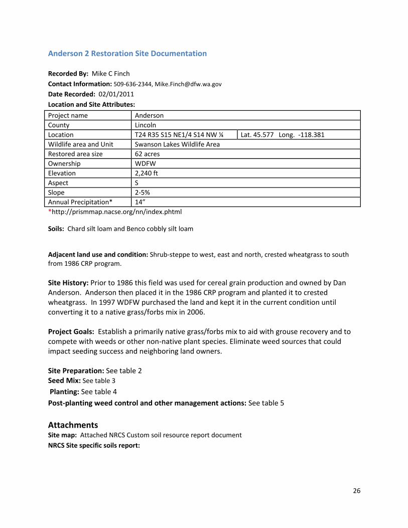
Anderson 2 Restoration Site Documentation
Recorded By: Mike C Finch
Contact Information: 509-636-2344, [email protected]
Date Recorded: 02/01/2011
Location and Site Attributes:
Project name Anderson
County Lincoln
Location T24 R35 S15 NE1/4 S14 NW ¼ Lat. 45.577 Long. -118.381
Wildlife area and Unit Swanson Lakes Wildlife Area
Restored area size 62 acres
Ownership WDFW
Elevation 2,240 ft
Aspect S
Slope 2-5%
Annual Precipitation* 14”
*http://prismmap.nacse.org/nn/index.phtml
Soils: Chard silt loam and Benco cobbly silt loam
Adjacent land use and condition: Shrub-steppe to west, east and north, crested wheatgrass to south from 1986 CRP program.
Site History: Prior to 1986 this field was used for cereal grain production and owned by Dan Anderson. Anderson then placed it in the 1986 CRP program and planted it to crested wheatgrass. In 1997 WDFW purchased the land and kept it in the current condition until converting it to a native grass/forbs mix in 2006. Project Goals: Establish a primarily native grass/forbs mix to aid with grouse recovery and to compete with weeds or other non-native plant species. Eliminate weed sources that could impact seeding success and neighboring land owners. Site Preparation: See table 2
Seed Mix: See table 3
Planting: See table 4
Post-planting weed control and other management actions: See table 5
Attachments Site map: Attached NRCS Custom soil resource report document
NRCS Site specific soils report:
27
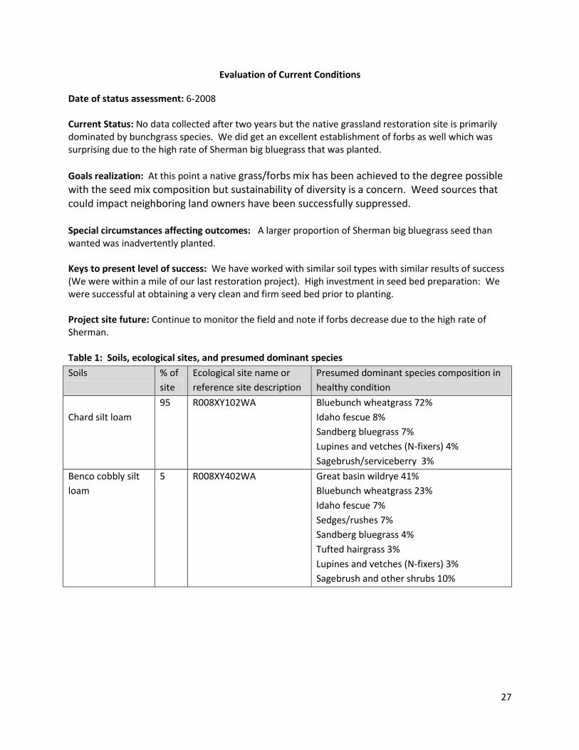
Evaluation of Current Conditions
Date of status assessment: 6-2008 Current Status: No data collected after two years but the native grassland restoration site is primarily dominated by bunchgrass species. We did get an excellent establishment of forbs as well which was surprising due to the high rate of Sherman big bluegrass that was planted.
Goals realization: At this point a native grass/forbs mix has been achieved to the degree possible with the seed mix composition but sustainability of diversity is a concern. Weed sources that could impact neighboring land owners have been successfully suppressed. Special circumstances affecting outcomes: A larger proportion of Sherman big bluegrass seed than wanted was inadvertently planted. Keys to present level of success: We have worked with similar soil types with similar results of success (We were within a mile of our last restoration project). High investment in seed bed preparation: We were successful at obtaining a very clean and firm seed bed prior to planting. Project site future: Continue to monitor the field and note if forbs decrease due to the high rate of Sherman. Table 1: Soils, ecological sites, and presumed dominant species
Soils % of
site
Ecological site name or
reference site description
Presumed dominant species composition in
healthy condition
Chard silt loam
95 R008XY102WA Bluebunch wheatgrass 72%
Idaho fescue 8%
Sandberg bluegrass 7%
Lupines and vetches (N-fixers) 4%
Sagebrush/serviceberry 3%
Benco cobbly silt
loam
5 R008XY402WA Great basin wildrye 41%
Bluebunch wheatgrass 23%
Idaho fescue 7%
Sedges/rushes 7%
Sandberg bluegrass 4%
Tufted hairgrass 3%
Lupines and vetches (N-fixers) 3%
Sagebrush and other shrubs 10%
28
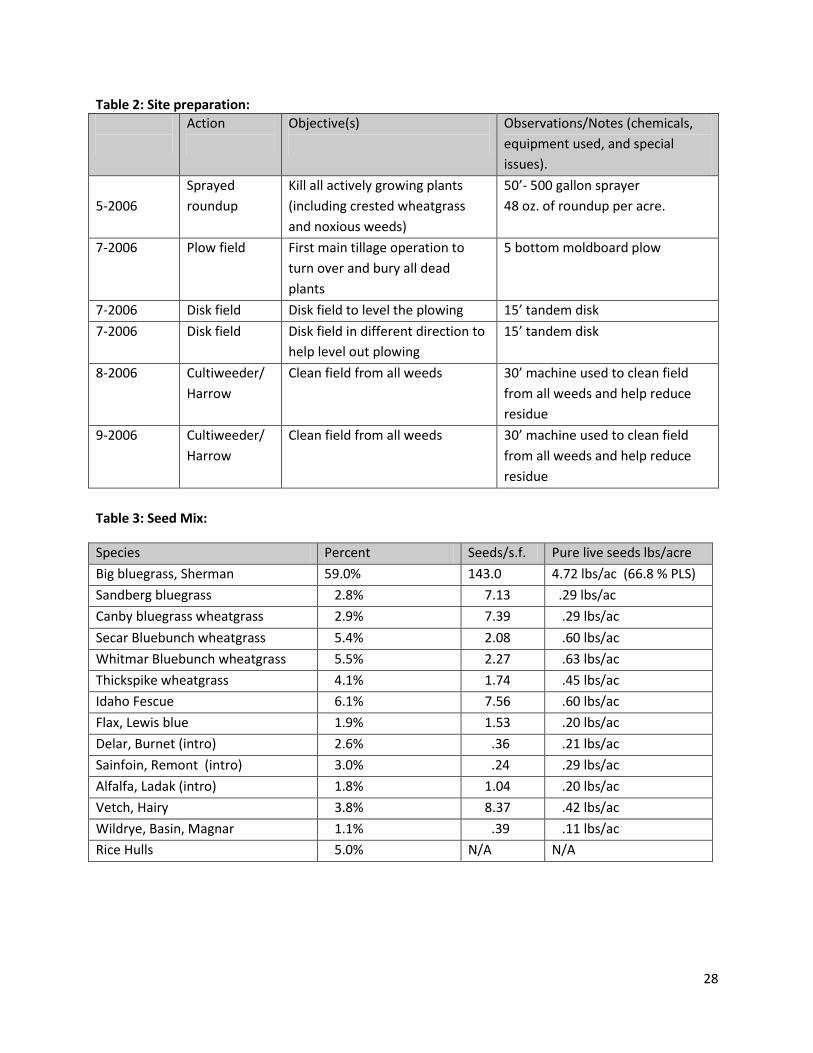
Table 2: Site preparation:
Action
Objective(s)
Observations/Notes (chemicals,
equipment used, and special
issues).
5-2006
Sprayed
roundup
Kill all actively growing plants
(including crested wheatgrass
and noxious weeds)
50’- 500 gallon sprayer
48 oz. of roundup per acre.
7-2006 Plow field First main tillage operation to
turn over and bury all dead
plants
5 bottom moldboard plow
7-2006 Disk field Disk field to level the plowing 15’ tandem disk
7-2006 Disk field Disk field in different direction to
help level out plowing
15’ tandem disk
8-2006 Cultiweeder/
Harrow
Clean field from all weeds 30’ machine used to clean field
from all weeds and help reduce
residue
9-2006 Cultiweeder/
Harrow
Clean field from all weeds 30’ machine used to clean field
from all weeds and help reduce
residue
Table 3: Seed Mix:
Species Percent Seeds/s.f. Pure live seeds lbs/acre
Big bluegrass, Sherman 59.0% 143.0 4.72 lbs/ac (66.8 % PLS)
Sandberg bluegrass 2.8% 7.13 .29 lbs/ac
Canby bluegrass wheatgrass 2.9% 7.39 .29 lbs/ac
Secar Bluebunch wheatgrass 5.4% 2.08 .60 lbs/ac
Whitmar Bluebunch wheatgrass 5.5% 2.27 .63 lbs/ac
Thickspike wheatgrass 4.1% 1.74 .45 lbs/ac
Idaho Fescue 6.1% 7.56 .60 lbs/ac
Flax, Lewis blue 1.9% 1.53 .20 lbs/ac
Delar, Burnet (intro) 2.6% .36 .21 lbs/ac
Sainfoin, Remont (intro) 3.0% .24 .29 lbs/ac
Alfalfa, Ladak (intro) 1.8% 1.04 .20 lbs/ac
Vetch, Hairy 3.8% 8.37 .42 lbs/ac
Wildrye, Basin, Magnar 1.1% .39 .11 lbs/ac
Rice Hulls 5.0% N/A N/A
29
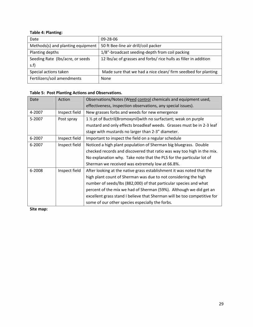
Table 4: Planting:
Date 09-28-06
Methods(s) and planting equipment 50 ft Bee-line air drill/coil packer
Planting depths 1/8”-broadcast seeding-depth from coil packing
Seeding Rate (lbs/acre, or seeds
s.f)
12 lbs/ac of grasses and forbs/ rice hulls as filler in addition
Special actions taken Made sure that we had a nice clean/ firm seedbed for planting
Fertilizers/soil amendments None
Table 5: Post Planting Actions and Observations.
Date Action
Observations/Notes (Weed control chemicals and equipment used,
effectiveness, inspection observations, any special issues).
4-2007 Inspect field New grasses forbs and weeds for new emergence
5-2007 Post spray 1 ½ pt of Buctril(Bromoxynil)with no surfactant; weak on purple
mustard and only effects broadleaf weeds. Grasses must be in 2-3 leaf
stage with mustards no larger than 2-3” diameter.
6-2007 Inspect field Important to inspect the field on a regular schedule
6-2007 Inspect field Noticed a high plant population of Sherman big bluegrass. Double
checked records and discovered that ratio was way too high in the mix.
No explanation why. Take note that the PLS for the particular lot of
Sherman we received was extremely low at 66.8%.
6-2008 Inspect field After looking at the native grass establishment it was noted that the
high plant count of Sherman was due to not considering the high
number of seeds/lbs (882,000) of that particular species and what
percent of the mix we had of Sherman (59%). Although we did get an
excellent grass stand I believe that Sherman will be too competitive for
some of our other species especially the forbs.
Site map:
30
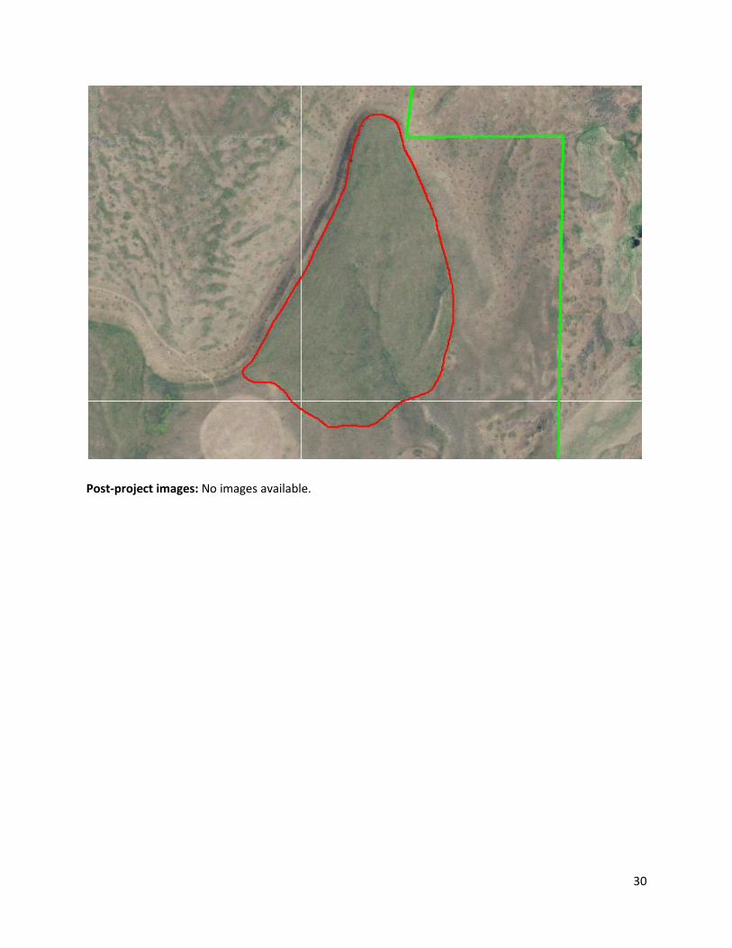
Post-project images: No images available.
31
Horace Smith Field Restoration Site Documentation
Recorded By: Dan Peterson
Contact information: 509-686-4305 [email protected]
Date Recorded: 1 March 2011
Location and Site Attributes:
Project name Horace Smith Field
County Douglas
Legal T28N, R25E, Sec 2 Lat47.9552, Long. -119.6454
Wildlife area and Unit Bridgeport Wildlife Area Unit
Restored area size 50 acres +/-
Ownership WDFW
Elevation 1,280 – 1,340 ft
Aspect Level to East/Northeast
Slope 0-3%
Annual Precipitation* 10.72 (1895 – 2010 average)
*http://prismmap.nacse.org/nn/index.phtml
Soils: Cashmere fine sandy loam, Ellisforde fine sandy loam, Torriorthents. See Table 1.
Adjacent land use and condition: Agriculture, primarily wheat border the north side. Shrub-steppe borders the west, south and east sides.
Site History: This site was used for growing wheat for most of the 20th Century. Conversion to agriculture likely occurred in the early 1900’s. The field had been maintained as fallow following the harvest in 2008 by the sharecropper, Lee Hanford. Lee had planned to plant wheat in 2009 and so had applied 40lbs of nitrogen to the site in August. Primary weeds in need of control included Russian thistle, annual bursage and annual rye. Seeding occurred in mid-November of 2009. Project Goals: To establish native shrub-steppe/meadow-steppe vegetation within a former agricultural field. The desired result is a diverse mix of native grass, forb and shrub species representative of the indigenous/native ecosystem of the area prior to European settlement. Positive outcomes of the project are to benefit the recovery efforts for the Columbian sharp-tailed grouse and greater sage grouse. Site Preparation: see Table 2, attached
Seed Mix: see Table 3, attached
Planting: see Table 4, attached
Post planting weed control and other management actions: see Table 5, attached

32
Evaluation of Current Conditions
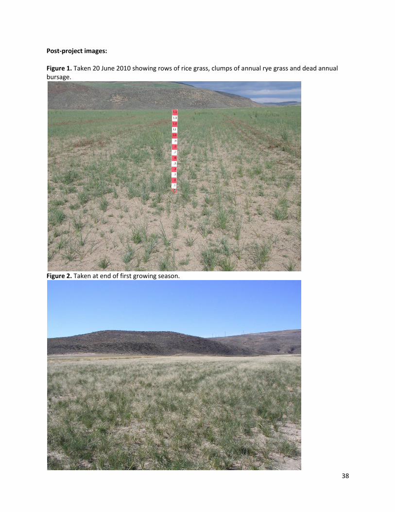
Date of status assessment: 2 March 2011 Current Status: Indian rice grass is the dominant grass at this time (see figures 1 and 2). Our past experience with this species suggests that over a period of several years its dominance will decline and will be replaced by bluebunch wheatgrass and the other species. In November 2010 we interseeded forbs on this site. It’s entirely possible that the present dense grass will inhibit the establishment of these forbs. Due to the extremely sandy soil, this site is strongly susceptible to wind erosion as can be seen in Figure 3. We included Indian rice grass in this seed mixture because we’ve found that it becomes established more quickly and robustly and thus reduces erosion of the site. More detailed information on this species can found in the USDA plant guide at http://plants.usda.gov/java/profile?symbol=ACHY Goals realization: It’s far too early in this process to assess goals realized.
Special circumstances affecting outcomes: Fertilizer application, above normal precipitation (15.5 inches in 2010) and forb interseeding in 2010. Keys to present level of success: Again, it’s far too soon to give any rational assessment of success or failure at this site. Project site future: Continue monitoring to assess grass and forb response. We anticipate that weed
species such as annual rye, annual bursage and Russian thistle will require periodic treatments for next
few years. Now t hat forbs have been seeded treatments likely will be limited to mowing and perhaps
harrowing. We will retain the option to do additional interseeding work if needed to improve species
diversity.
33
Table 1: Soils, ecological sites, and presumed dominant species
Soils % of
site
Ecological site name or
reference site description
Presumed dominant species composition in
healthy condition
Predominant soils:
Cashmere fine
sandy loam, 0 to 3
and 8 to 15
percent slopes
92.7 R008XY101WA Bluebunch wheatgrass 60%
Sandberg Bluegrass 10%
Big Sagebrush 5%
Muttongrass 5%
Thurber needlegrass 3%
Fleabane 2%
Longleaf phlox 2%
Arrowleaf balsamroot 2%
Lupine 2%
Milkvetch2%
Gray rabbitbrush 2%
Buckwheat 2%
Slopes,
Torriorthents, very
steep
6.9 R008WY501WA Needle and thread 25%
Bluebunch wheatgrass 20%
Sandberg Bluegrass 10%
Sagebrush 5%
Antelope bitterbrush 5%
Buckwheat 5%
Arrowleaf balsamroot 5%
Pricklypear 2%
Gray rabbitbrush 2%
Lupine 1%
Table 2: Site preparation:
Date Action
Objective(s)
Observations/Notes (chemicals,
equipment used, and special
issues).
Aug 2008
Harvest wheat
crop
To remove standing wheat crop,
transport to elevator
Done by Lee Hanford,
sharecropper.
Sept 2008 -
Fall, 2009
Cultivate Incorporate wheat stubble into
ground. Multiple operations
occurred during this period.
Done by Lee Hanford,
Fall, 2009 Fertilize Applied nitrogen at 40lbs/ac Done by Lee Hanford to prep field
for next wheat crop
11/2009 Harrow Remove fall annuals and smooth
seed bed.
15 foot spike-tooth harrow
11/2009 Pack Create firm seed bed. 12 foot culti-packer
34
Table 3: Seed Mix 1:
Species Percent Seeds/s.f. Pure live seeds lbs/acre
Duffy Creek Sandberg
Bluegrass
12.74 0.6
Wahluke Bluebunch
Wheatgrass
13.09 4.0
Winchester Idaho Fescue 7.74 0.75
Schwindimar Thickspike
Wheatgrass
3.58 1.0
Table 3b: Seed Mix 2:
Species Percent Seeds/s.f. Pure live seeds lbs/acre
Nezpar Indian Rice Grass 17.53 3.25
Antelope Bitterbrush 1.05 3.0
Table 3c: Forb Mix:
Species Percent Seeds/s.f. Pure live seeds lbs/acre
Blue Mountain Prairie Clover 1.09 0.15
Venus Penstemon 3.03 0.15
Small Burnett 1.14 1.0
Lewis Flax 1.92 0.2
White Native Yarrow 5.57 0.09
Arrowleaf Balsamroot 0.44 0.35
Threadleaf Fleabane 0.55 0.08
Long-leaved Phlox 0.19 0.03
Snow Buckwheat 2.89 0.4
Shaggy Fleabane 4.13 0.1
Table 4a: Planting, Seed Mix 1:
Date 3-4 November, 2009
Methods(s) and planting equipment 12 foot Truax Flex II drill
Planting depths ½ to ¾ inches, approximately, using 12 inch diameter depth bands mounted on drill
Seeding Rate (lbs per acre, or seeds
per foot)
6.35lbs per acre. 37.16 seeds per square foot.
Special actions taken Used middle box, aka fluffy box, on Truax. Rice hulls added to mix at rate of 3lbs per acre. Total rate = 9.35lbs per acre
Fertilizers/soil amendments None
35
Table 4b: Planting, Seed Mix 2:
Date 3-4 November, 2009
Methods(s) and planting equipment 12 foot Truax Flex II drill
Planting depths 1.75 to 2 inches, approximately, using 9.5 inch diameter depth bands mounted on drill
Seeding Rate (lbs per acre, or seeds
per foot)
6.25lbs per acre. 18.59 seeds per square foot.
Special actions taken Used rear box on Truax. White rice added to mix at rate of 4lbs per acre. Total rate = 10.25lbs per acre
Fertilizers/soil amendments None
Table 4b: Planting, Seed Mix 2:
Date 3-4 November, 2009
Methods(s) and planting equipment 12 foot Truax Flex II drill
Planting depths ½ to ¾ inches, approximately, using 12 inch diameter depth bands mounted on drill
Seeding Rate (lbs per acre, or seeds
per foot)
3.485lbs per acre. 20.98 seeds per square foot.
Special actions taken Used rear box on Truax. Rice hulls added to mix at rate of 9.5lbs per acre. Total rate = 12.98lbs per acre
Fertilizers/soil amendments None
36
Table 5: Post Planting Actions and Observations.
Date Action
Observations/Notes (Weed control chemicals and equipment used,
effectiveness, inspection observations, any special issues).
3/2010 Inspect field Monitor grass and annual weed growth
4/2010 Inspect field Monitor grass and annual weed growth
4/19/2010 Spray Treat annual bursage and Russian thistle. Used BroClean (a generic
Buctril (Bromoxynil) at 12oz/ac, 2,4-D at 8oz/ac, dicamba at 3oz/ac plus
Choice at 4oz and Spreader 90 at 4oz. Used Kubota and 30 foot pull-
behind sprayer rented from CPS in Coulee City.
5/3/2010 Inspect field Assess herbicide application. Excellent kill on annuals. Some skips,
primarily where Kubota traveled traveled.
5/6/2010 Spray Treat Dalmatian toadflax in adjacent 20 acre field. Used Tordon 22K at
2qt/ac and 2,4-D at 2 pt/ac. Spot sprayed with ATV
6/8/2010 Spray Treat annual bursage and Russian thistle in skips left from April
treatment. Used same herbicides and rates. Sprayed with Ford truck
and slip-in sprayer.
6/2010 Mow (2X) Mowed annual rye to reduce seed production.
6/29/2010 Spray Treat Russian thistle. Used same herbicides and rates as April
treatment. Sprayed with Kubota and 3-point sprayer
7/2010 Mow Mowed annual rye to reduce seed production.
7-11/2010 Inspect field Inspected multiple times during this period. The response of the Indian
rice grass has been remarkable, it clearly dominates the stand.
Thickspike appears to be the second most common species follow by
bluebunch and Sandberg’s. At this time we feel that three factors have
influenced the rice grass: seeding depth, above normal precipitation
and the fertilizer treatment that Lee applied.
11/18-
19/2010
Interseed
forbs
Used Truax Flex II with 12 inch depth bands attached to achieve
planting depth of ½ - ¾ inches.
Attachments Site map: For more details see attached site-specific soil survey
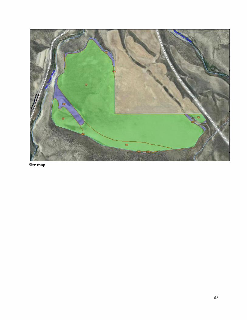
37
Site map
38
Post-project images: Figure 1. Taken 20 June 2010 showing rows of rice grass, clumps of annual rye grass and dead annual bursage.
Figure 2. Taken at end of first growing season.
39
Pre-project images
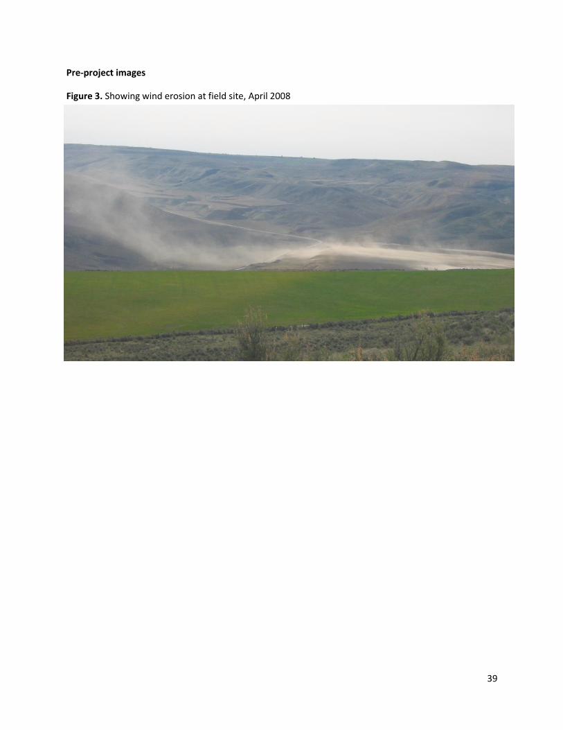
Figure 3. Showing wind erosion at field site, April 2008
40
Rattlesnake Slope Post–Fire Restoration Site Documentation
Recorded By: Rocky Ross Contact information: 509-539-1136 Date Recorded: January 18, 2011
Location and Site Attributes:
Project name Rattlesnake Slope post-fire restoration
County Benton
Location T10N R26E gen. area S8,17,18 &19 Lat. 46.359 Long. -119.453
Wildlife area and Unit Rattlesnake Slope, Sunnyside
Restored area size 160
Ownership WDFW
Elevation 500 feet
Aspect SE
Slope Variable
Annual Precipitation 7-8 inches
Soils: Not mapped by NRCS. Sandy, well drained
Adjacent land use and condition: Public land with similar weed control issues. Shooting range-fire hazard.
Site History: Grazed in the past. Wildfires occurred in the summer of 2000 and on July 16, 2003. Restoration areas were nearly devoid of any evidence that native bunchgrass (other than Sandburg
bluegrass) existed prior to the fire. Fires killed most shrubs. Presumed historic condition is Columbia plateau steppe and Grassland: Extensive grasslands, dominated by perennial bunch grasses and forbs (>25% cover) sometimes with a sparse (<10% cover) shrub layer. Presumed dominants include: Sandberg bluegrass, bluebunch wheatgrass, big sagebrush, yarrow.
Project Goals: Get as much native cover as possible to compete with weeds Establish forbs and sagebrush to aid in sage grouse recovery Establish forage to attract elk for hunting (a driver for including winterfat)
Site Preparation: Harrowed only. See Table 2
Seed Mix: See Table 3
Planting: See Table 4
Post-planting weed control and other management actions: See Table 5
41
Evaluation of Current Conditions
Date of status assessment: ____2008__________
Current Status: Data analysis not available. Performance measures were not originally specified for
this site but after 6 years the following observations were made: Visually, the seeding operation
appears to be successful based on the representative photo shown below. A comparison of the 3
treatments probably can’t be made without analyzing the collected data. All data collected remains on
the original data sheets and was never analyzed. Mike Keller, the new Wildlife Area Manager, or Robby
Sak, Assistant Manager, should have the data sheets.
Goals realization: This was a very harsh site and I’m very satisfied with the results we got. It’s very hard
to get a good stand of any native vegetation in a desert environment, especially when you seed both
grass and broadleaves and have to deal with weeds.
Special circumstances affecting outcomes: We were blessed with the right amount of moisture when we seeded and again after seeding was complete. The soil remained unfrozen during the process so our tillage was very effective and we got good soil to seed contact. Keys to present level of success: I monitored the sites weekly as the weather started to warm up so we could get our herbicide on at precisely the right time. We sprayed early enough so that late germinating winterfat and sage were unaffected. We unintentionally seeded heavier than anticipated and this added to our plant density. Results too mixed to make many definitive conclusions about the different fields based on casual observation. Aerial herbicide applicator error was a confounding factor. Conclusions regarding herbicides.
Plateau
o A single 3 oz/acre application was very damaging to desirable species on WDFW test
plots.
o Two 4 oz/acre applications severe damage to desirable species on adjacent USFWS
planting areas.
Buctril
o Controlled some of the broadleaves
o 90% of the winterfat that had emerged (2 to 3 leaf stage) was killed.
o Did not have an apparent effect on many broadleaf plants including Draba verna and
fiddleneck tarweed.
Project site future: No comment.
42
Table 1: Soils, ecological sites, and presumed dominant species NRCS has not mapped site yet. Associated ecological sites and presumed dominant species information
not available. Soil sandy and well drained.
Table 2: Site preparation:
Date Action
Objective(s)
Observations/Notes (chemicals,
equipment used, and special
issues).
Dec 2003
(First week)
Harrow Prepare seed bed Harrowed twice after first good
hard rain of season. Moisture
helped. Second pass
perpendicular to first. Surface
irregular. Treated soil varied from
loose to only scratched.
Table 3: Seed Mix:
Species Mix A Mix B _____Rate__________
Sandburg bluegrass (Hanford collection) 550 lb 33 lb 2.5 lb/acre
Bluebunch wheatgrass (Wahluke collection) 880 lb 52 lb 4.0 lb/acre
Thickspike wheatgrass (Schwindimar) 770 lb 46 lb 3.5 lb/acre
Big Sagebrush (var. wyomingensis) 33 lb 3 lb 0.15 lb/acre
Winterfat 110 lb 7 lb 0.5 lb/acre
White yarrow (millefolium) 66 lb 5 lb 0.3 lb/acre
Table 4: Planting:
Date First week of December 2003
Methods(s) and planting
equipment
Tye drill in fire line and along highway, aircraft everywhere else.
Rice hulls used to suspend seed in Tye drill.
Planting depths Not recorded. Indian ricegrass ”very deep”
Seeding Rate (lbs per acre, or
seeds per foot)
Estimated 15 lbs/acre
Special actions taken Follow-up tillage on aerially seeded areas on December 6-19th to
improve seed/soil contact. Three different treatment were tried
Field A: Harrowed once and then packed with 14 foot Schmeiser
packer.
Field B: Only harrowed
Field C: Only packed
Fertilizers/soil amendments None
43
Table 5: Post Planting Actions and Observations.
Date Action
Observations/Notes (Weed control chemicals and equipment used,
effectiveness, inspection observations, any special issues).
3/2004
(first week)
Spray USFWS applied 3oz/acre of Plateau on two DFW test plots in field A and
B. USFWS applied 4oz/acre on all of their adjacent planted areas (and
then a second time a month or two later).
3/9-10/2004 Spray Intended to Kill weeds including cheatgrass. Mirage (glyphosate) used
at 3.5 oz per acre on the entire burned area on except for fields A and
C. Field B was loaded with cheatgrass.
3/10/2004 Spray Buctril at 18 oz/acre with Spreader 90 at 10oz/100 gal. water on all
seeded fields.
12/19/03-
4/24/04
Multiple
inspections
Check weeds /results of spraying. Weather wise, we’ve had two brief
rain showers since the snow went off. See detailed notes about
herbicide effects*
*On 3/24/04, The entire Plateau –treated area looks like it was sprayed with a non selective
herbicide from a distance. Up close, there is surviving Sandburg and some small restoration grass
seedlings but little else. No cheat or annual broadleaves present.
On March 24, Fields A and B were checked and results were mixed. Some of the Sandburg bluegrass is
extremely red with just a hint of green color remaining. Other Sandburg appears to be unaffected or
nearly so. A lot of cheatgrass is dying but a new flush (or missed seedlings) appears unaffected. In
addition, on field B, the pilot completely missed a wide band that runs parallel to the Plateau strip.
That strip easily exceeds 100 feet in width. The results overall are so mixed at this time, it’s hard to
know if it was operator error or some other element of the operation.
The Buctril appears to have controlled some of the broadleaves but a lot of Draba verna has flowered
and there is a lot of fiddleneck tarweed that was either partially affected or missed altogether. The
sad part is that 90% of the winterfat that had emerged has apparently been killed. A few live plants
were found in today’s survey but the majority appear to be lost. They were mostly in the 2 to 3 leaf
stage when the Buctril was applied. The seed fuzz clings to the cotyledon leaves, even after they are
fully emerged and could possibly act like a sponge for the herbicide, holding it against the plant for a
longer period and doing more damage. Field A was not sprayed with Roundup and there is a lot of
cheatgrass emerging in that field. The entire field has a green hue from the unaffected cheat and
small broadleaves. All of the Lomatium appears healthy, along with a few scattered balsamroots, lots
of filaree, and other broadleaf plants. The Buctril did not have an apparent effect on very many of
the broadleaf plants.
I found no emerged sagebrush plants on 3/24.
From a distance, the USFWS land across the fence to the north looks totally devoid of vegetation. The
total application of 8 oz per acre could have damaged the perennial plants but we’ll know more this
44
summer.
I did not check field C for results (shooting range open) of the spray operation.
Plateau plots devoid of vegetation except for established Sandburg bluegrass and it has been
suppressed to the point of not producing seed heads.
4/14/2004 Inspection Accompanied by Jerry Benson. Weather has been unseasonably dry
and warm. See detailed notes about herbicide effects**
**4/14/04
Plot A: (harrowed and packed post seeding, sprayed with Buctril only) Lots of restoration grasses and
yarrow evident (and almost too thick). Found one or two winterfat and no sage. Cheat is scattered
and 2-3 inches tall, some just pushing a head. Much of the fiddleneck is gone and the only broadleaf
of substance is filaree. Perennial broadleaves are thriving.
Plot B: (only harrowed after seeding, sprayed with 3.5 oz of Roundup and 18 oz of Buctril 36 hours
later) Established Sandburg was hit hard in places and those same areas show very little restoration
grass coming. It’s possible that the Sandburg bunches were so dense, the harrow could not mix up
much soil. A lot of the Sandburg looks like it could actually die, where a lot in other areas appears to
just be set back. It’s red in color but has a little green at the base and has put up seed heads. Where
the Sandburg is still hanging on, the restoration grass is also coming. Much less evidence of
yarrow/winterfat and no sage yet. Only an occasional Russian thistle showing. Plot C: (only packed
after seeding, only Buctril at 18 oz) Good survival of Sandburg and bluebunch. Good presence of
restoration grasses. Not much yarrow, no winterfat or sage.
Jerry’s assessment was that most of the area looks as good as it could be under the conditions we
have had. The cheatgrass is so small, it’s likely that it won’t provide much competition. Broadleaf
weeds appear to be minimal. A rain + warm temps could bring on a flush of R. thistle which we can’t
do anything about at this point in time.
6/8/04 Observation Heavy rain - 0.77in. recorded in Hanford. Even heavier rain observed a
few weeks earlier but not recorded.
6/9/04 -
6/14/04
Monitoring Gather vegetation data. Sampled plot C: Quantitative data collected.
Casual observations: Grass seedlings were almost too dense. Winterfat
was occasional. Sage was present but uncommon.
Russian thistle is present in substantial numbers and will likely cause a
mess due to all the moisture. The spring has been unseasonably cool
and wet.
Summer
2005
Monitoring Gather vegetation data. We completed transects on all 3 treatment
areas in 2004 and repeated those transects again one year later.
Fall
2006
Reseeding Establish native vegetation in areas sprayed with Plateau. No details
available.
45
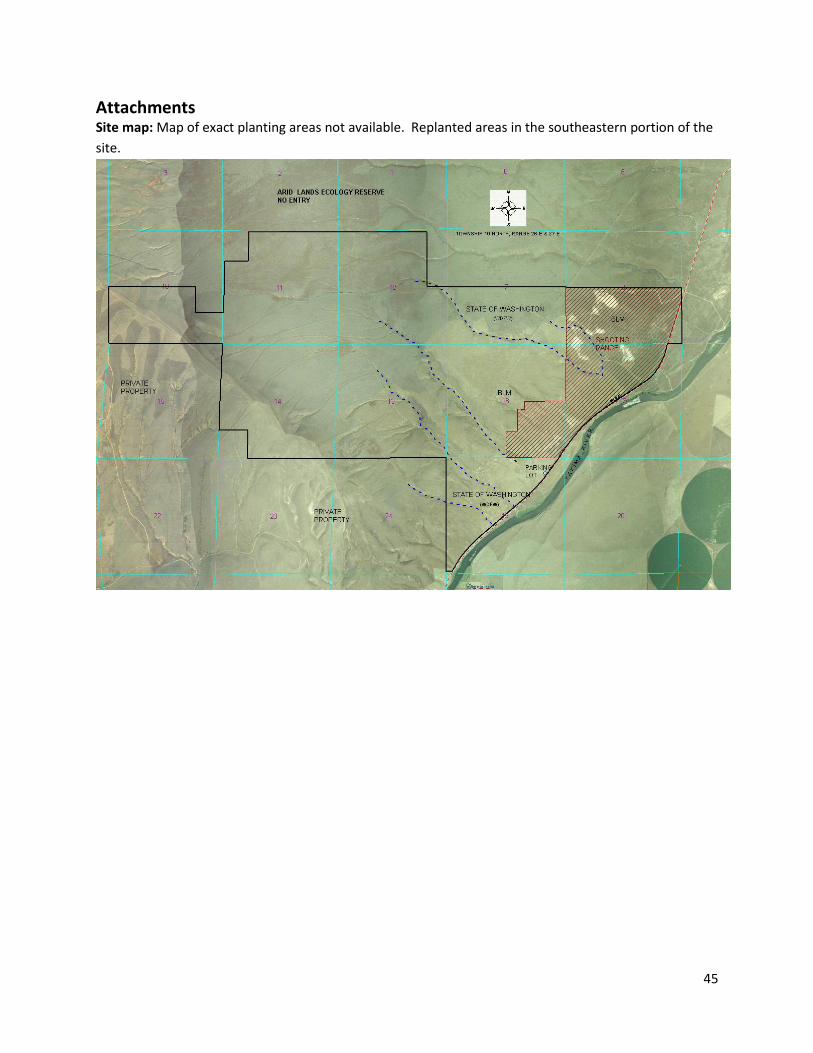
Attachments Site map: Map of exact planting areas not available. Replanted areas in the southeastern portion of the
site.
46
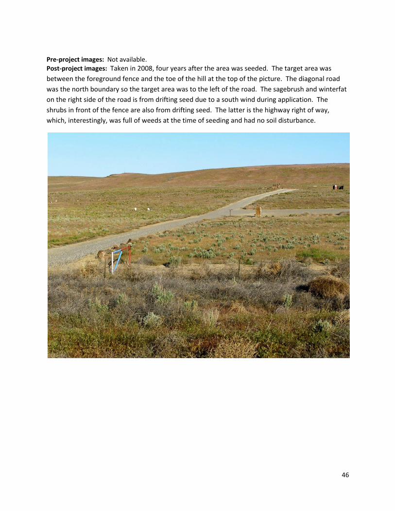
Pre-project images: Not available.
Post-project images: Taken in 2008, four years after the area was seeded. The target area was
between the foreground fence and the toe of the hill at the top of the picture. The diagonal road
was the north boundary so the target area was to the left of the road. The sagebrush and winterfat
on the right side of the road is from drifting seed due to a south wind during application. The
shrubs in front of the fence are also from drifting seed. The latter is the highway right of way,
which, interestingly, was full of weeds at the time of seeding and had no soil disturbance.
47
Sunnyside Alkaline Restoration Site Documentation
Recorded By: Robby Sak
Contact Information: 509-840-2877 [email protected]
Date Recorded: February 10, 2011
Location and Site Attributes:
Project name Sunnyside Restoration Field (Alkaline) Restoration
County Yakima
Location T19N R22E S23 SE1/4 Lat. 46. 246 Long. -120.027
Wildlife area and Unit Sunnyside, Headquarters
Restored area size 18
Ownership WDFW
Elevation 630 feet
Aspect Level
Slope Level
Annual Precipitation* 7-8 inches
Soils: 84% of site Esquatzel silt loam,0-2% slopes. Max. calcium carbonate 5%. Depth to water >80 inches 116% Umapine silt loam, drained, 0-2% slopes. Max. calcium carbonate 30%. Depth to water 24-48 inches. Adjacent land use and condition: Agriculture to the north Greasewood flats to East, South and West. Site History: Ag field for small grain/ Alfalfa rotation. Before 1997 field was flood irrigated. In 1997 Pump and mainline was installed and a wheel line was used to irrigate. In 2000 Ag Leaser stopped farming site and WDFW staff continued with small grain food plot for next 4 yrs. The site was then idle for 3yrs prior to restoration with a high density of Kochia, Russian Knapweed and Russian thistle. Presumed historic condition: INTER-MOUNTAIN BASINS GREASEWOOD FLAT. A mosaic of open to moderately dense greasewood (Sarcobatus vermiculatus) shrublands with grasses. Dominant grass in low areas is inland saltgrass. Great Basin Wildrye (Leymus cinereus) was prominent in high spots. Note: NRCS has not developed ecological site description for the site. See table 1 Project Goals: Get as much native cover as possible to compete with weeds (Russian knapweed and Kochia) Establish forage and nesting cover for mallard ducks, pheasant, and quail. Note regarding goals: A decision was made against trying to plant greasewood as past attempts to grow it on the wildlife area and via contract nursery grower were unsuccessful. The reason we wanted to use the tall wheatgrass was to help get more cover on the saltier areas. Tall wheatgrass has been used around here for pastures since the 50’s on the more alkali soils. We knew that the saltgrass would eventually fill in but it doesn’t provide good nesting/hiding cover. Since we haven’t been very successful in planting greasewood we wanted to have taller cover in this area and using tall wheatgrass in our mix would give us that. The basin wildrye will not grow very well in the more alkali areas, tending to grow alongside those areas leaving big voids out in the landscape. When we added the tall wheatgrass we
48
were able to fill in some of those voids and provide better nesting/hiding cover. It is hoped that greasewood will eventually re-invade the site. Site Preparation: See Table 2 Seed Mix: See Table 3
Planting: See Table 4
Post-planting weed control and other management actions: See Table 5
Evaluation of Current Conditions
Date of status assessment: ____February 2011 (two years after planting)__________ Current Status: An even mix of tall wheatgrass and basin wildrye dominate the area. Weed cover is
below 3%. Some areas that are more alkali than others remain bare or have very short vegetation due to
high salt levels. Native salt grass is starting to appear in some of these higher salt areas.
Goals realization: Very satisfied with the results. It’s very hard to re-establish Alkali soils after the
native vegetation has been missing for so many years. Weeds are under control. Great basin wildrye
and tall wheatgrass gave us the desired forage and nesting cover.
Special circumstances affecting outcomes: We did a late fall planting based on the weather. We had a few good rains before we planted and a snow storm the next day after we got done. I think with that amount of moisture we were able to drive the salts down into the soil away from the seed. Keys to present level of success: I think it was the above normal moisture that fall and the kind of site prep we did before planting. Project site future: Right now I think the objective would be to keep a close watch on the area for weed
infestation. No burning or mowing is needed at this time. We purposely have not tried to plant
greasewood on this site. In years past we tried greasewood plugs from seed in different areas without
much success. Our hope is that the established greasewood that boarders both the west and east side
of this site will eventually fill in by natural seed distribution. Native salt grass is starting to appear in
some of these higher salt areas and should fill eventually its niche.
49
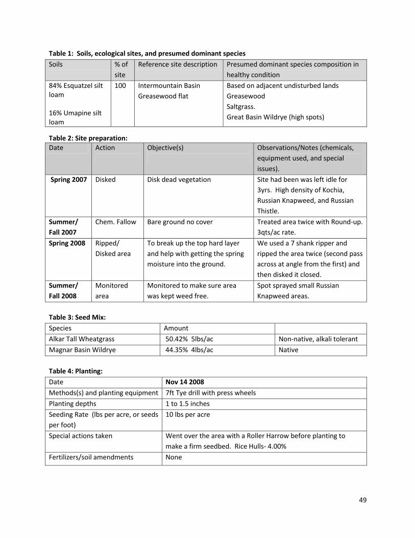
Table 1: Soils, ecological sites, and presumed dominant species
Soils % of
site
Reference site description Presumed dominant species composition in
healthy condition
84% Esquatzel silt loam 16% Umapine silt loam
100 Intermountain Basin
Greasewood flat
Based on adjacent undisturbed lands
Greasewood
Saltgrass.
Great Basin Wildrye (high spots)
Table 2: Site preparation:
Date Action
Objective(s)
Observations/Notes (chemicals,
equipment used, and special
issues).
Spring 2007 Disked Disk dead vegetation Site had been was left idle for
3yrs. High density of Kochia,
Russian Knapweed, and Russian
Thistle.
Summer/
Fall 2007
Chem. Fallow Bare ground no cover Treated area twice with Round-up.
3qts/ac rate.
Spring 2008 Ripped/
Disked area
To break up the top hard layer
and help with getting the spring
moisture into the ground.
We used a 7 shank ripper and
ripped the area twice (second pass
across at angle from the first) and
then disked it closed.
Summer/
Fall 2008
Monitored
area
Monitored to make sure area
was kept weed free.
Spot sprayed small Russian
Knapweed areas.
Table 3: Seed Mix:
Species Amount
Alkar Tall Wheatgrass 50.42% 5lbs/ac Non-native, alkali tolerant
Magnar Basin Wildrye 44.35% 4lbs/ac Native
Table 4: Planting:
Date Nov 14 2008
Methods(s) and planting equipment 7ft Tye drill with press wheels
Planting depths 1 to 1.5 inches
Seeding Rate (lbs per acre, or seeds
per foot)
10 lbs per acre
Special actions taken Went over the area with a Roller Harrow before planting to
make a firm seedbed. Rice Hulls- 4.00%
Fertilizers/soil amendments None
50
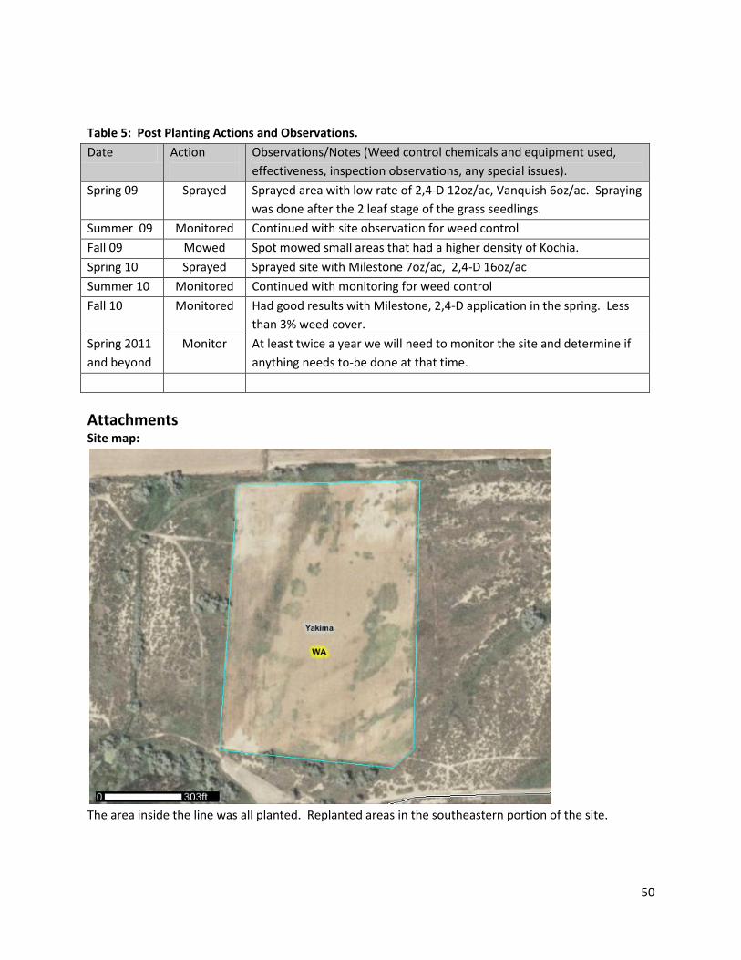
Table 5: Post Planting Actions and Observations.
Date Action
Observations/Notes (Weed control chemicals and equipment used,
effectiveness, inspection observations, any special issues).
Spring 09 Sprayed Sprayed area with low rate of 2,4-D 12oz/ac, Vanquish 6oz/ac. Spraying
was done after the 2 leaf stage of the grass seedlings.
Summer 09 Monitored Continued with site observation for weed control
Fall 09 Mowed Spot mowed small areas that had a higher density of Kochia.
Spring 10 Sprayed Sprayed site with Milestone 7oz/ac, 2,4-D 16oz/ac
Summer 10 Monitored Continued with monitoring for weed control
Fall 10 Monitored Had good results with Milestone, 2,4-D application in the spring. Less
than 3% weed cover.
Spring 2011
and beyond
Monitor At least twice a year we will need to monitor the site and determine if
anything needs to-be done at that time.
Attachments
Site map:
The area inside the line was all planted. Replanted areas in the southeastern portion of the site.
51
Pre-project images: None.
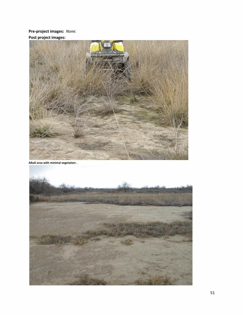
Post project images:
Alkali area with minimal vegetation .
52
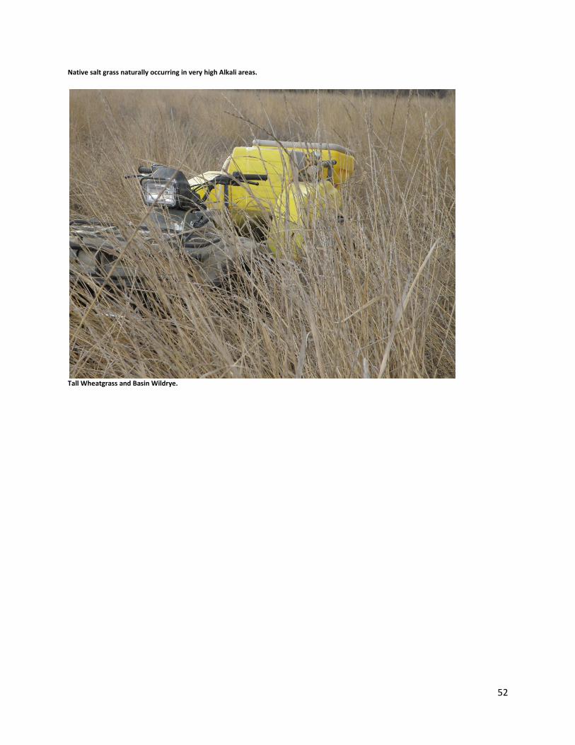
Native salt grass naturally occurring in very high Alkali areas.
Tall Wheatgrass and Basin Wildrye.
53
Sheridan Field Restoration Site Documentation
Recorded By: Pete Lopushinsky
Contact information: 509-663-6260- [email protected]
Date Recorded: April 20, 2011
Location and Site Attributes:
Project name Sheridan Field
County Kittitas
Location T.20N, R.21E, sec 10, sw1/4 Lat.47.2333 Long. -120.1875
Wildlife area and Unit Colockum
Restored area size 38 acres
Ownership WDFW
Elevation 2,700 ft
Aspect Level to slightly eastward sloping
Slope 0-3%
Annual Precipitation* 19”
Soils: 98% Meystre loam 0-15%. See table 1. Adjacent land use and condition: Relatively healthy ponderosa pine forest, grassland and shrub steppe
and. No development, agriculture or livestock grazing in the immediate vicinity. Tree cover is probably
much higher than the historic condition due to fire suppression,
Site History: Trees were probably cleared prior to agricultures. This was a farmed grain field, with
many problem weeds: Russian knapweed, diffuse knapweed, morning glory, jointed goatgrass and
cereal rye.
Project Goals and objectives : Establish native –species dominated plant community as a grass pasture for elk
Restore the Bluebunch wheatgrass and Idaho fescue dominants
o with combined native grass cover to exceed 80% and o No single species to exceed 80% of the total plant cover
Control noxious weeds (Noxious weeds not to exceed 1% cover)
Stabilize soils
Note: No forbs were planted due to noxious weed control issues.
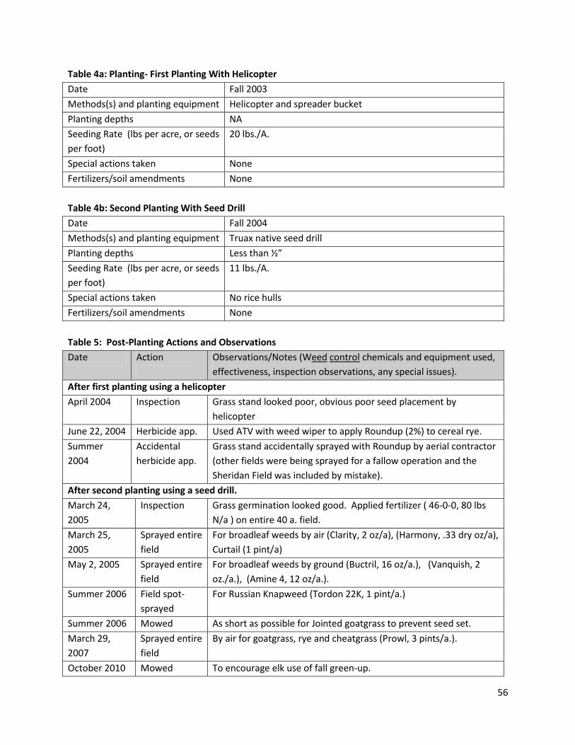
Site preparation: See table 2a and 2b
Seed Mix: See table 3
Planting: (Table 4a and 4b, attached)
54
Post-planting weed control and other management actions: (see Table 5, attached)
Evaluation of Current Conditions Date of status assessment: 04/20/2011. Seven years after planting. Current Status: This field now looks really good, goatgrass and other weeds are at a very low level. The
field will be mowed and fertilized occasionally and managed as a green grass pasture. This is an effort to
make it attractive to elk and encourage them to remain on public lands instead of causing crop damage
on nearby private lands.
Goals realization: Goal met. Native pasture with desired dominant grasses established. The pasture is
heavily used by elk. Weeds and erosion are effectively controlled.
Lessons learned: Seeding with helicopters can be problematic, especially in windy sites. We also were not able to harrow after aerial seeding, which may have improved success. The unplanned application of Roundup was probably due to a misunderstanding with the aerial applicator. Mowing was effective in reducing goatgrass and rye, as was the application of Prowl herbicide. Special circumstances that may have affected project outcomes (unusual weather, wildfires etc.):
None. Key’s to present level of success:
Planting spring wheat the year before grass seeding seemed to reduce annual grass weeds. Use of the Truax seed drill was obviously very effective in seedling establishment.
Anticipated site trajectory: Use mowing and fertilization to keep grass succulent and competitive.
Watch for possible re-invasion of Russian knapweed and other weeds.
Possible steps to further improve conditions: None planned. Diversity should increase via invasion
from surrounding in-tact communities.
55
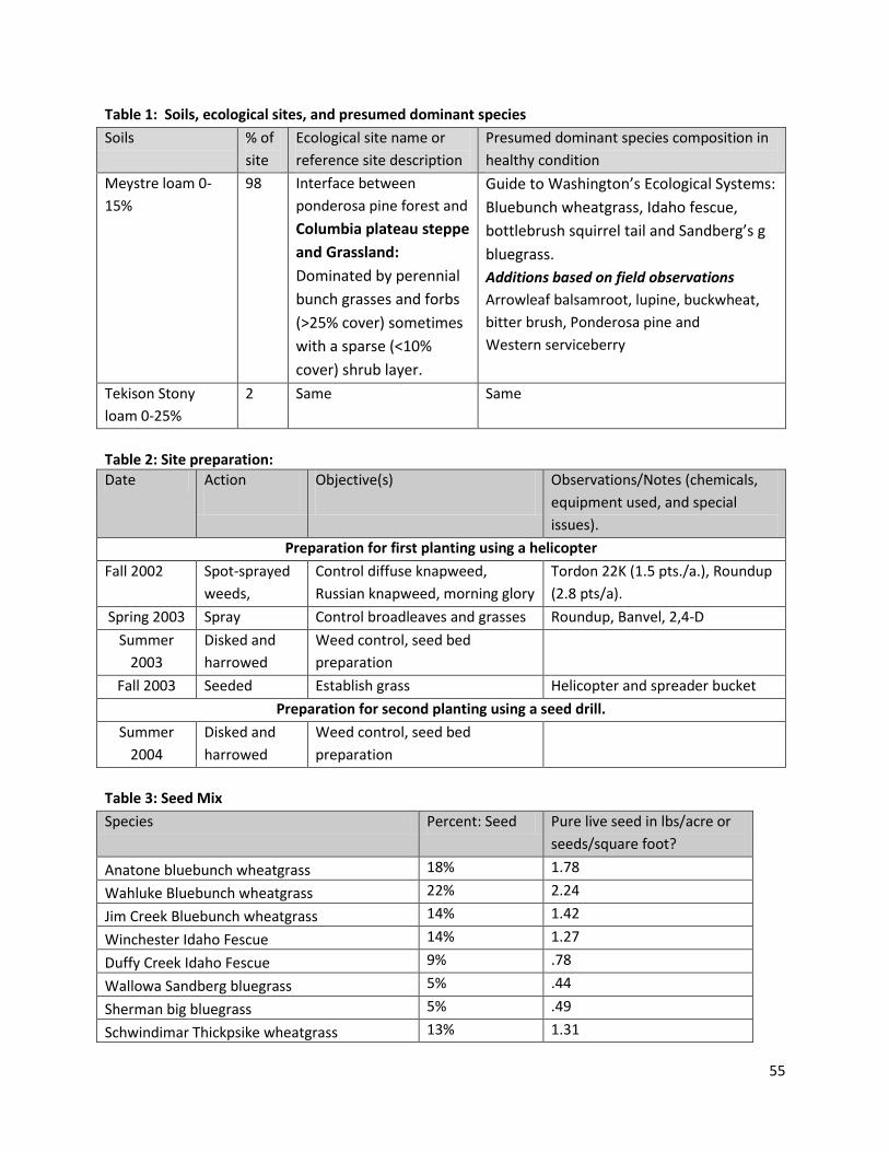
Table 1: Soils, ecological sites, and presumed dominant species
Soils % of
site
Ecological site name or
reference site description
Presumed dominant species composition in
healthy condition
Meystre loam 0-
15%
98 Interface between
ponderosa pine forest and
Columbia plateau steppe
and Grassland:
Dominated by perennial
bunch grasses and forbs
(>25% cover) sometimes
with a sparse (<10%
cover) shrub layer.
Guide to Washington’s Ecological Systems:
Bluebunch wheatgrass, Idaho fescue,
bottlebrush squirrel tail and Sandberg’s g
bluegrass.
Additions based on field observations
Arrowleaf balsamroot, lupine, buckwheat,
bitter brush, Ponderosa pine and
Western serviceberry
Tekison Stony
loam 0-25%
2 Same Same
Table 2: Site preparation:
Date Action
Objective(s)
Observations/Notes (chemicals,
equipment used, and special
issues).
Preparation for first planting using a helicopter
Fall 2002 Spot-sprayed
weeds,
Control diffuse knapweed,
Russian knapweed, morning glory
Tordon 22K (1.5 pts./a.), Roundup
(2.8 pts/a).
Spring 2003 Spray Control broadleaves and grasses Roundup, Banvel, 2,4-D
Summer
2003
Disked and
harrowed
Weed control, seed bed
preparation
Fall 2003 Seeded Establish grass Helicopter and spreader bucket
Preparation for second planting using a seed drill.
Summer
2004
Disked and
harrowed
Weed control, seed bed
preparation
Table 3: Seed Mix
Species Percent: Seed Pure live seed in lbs/acre or
seeds/square foot?
Anatone bluebunch wheatgrass 18% 1.78
Wahluke Bluebunch wheatgrass 22% 2.24
Jim Creek Bluebunch wheatgrass 14% 1.42
Winchester Idaho Fescue 14% 1.27
Duffy Creek Idaho Fescue 9% .78
Wallowa Sandberg bluegrass 5% .44
Sherman big bluegrass 5% .49
Schwindimar Thickpsike wheatgrass 13% 1.31
56
Table 4a: Planting- First Planting With Helicopter
Date Fall 2003
Methods(s) and planting equipment Helicopter and spreader bucket
Planting depths NA
Seeding Rate (lbs per acre, or seeds
per foot)
20 lbs./A.
Special actions taken None
Fertilizers/soil amendments None
Table 4b: Second Planting With Seed Drill
Date Fall 2004
Methods(s) and planting equipment Truax native seed drill
Planting depths Less than ½”
Seeding Rate (lbs per acre, or seeds
per foot)
11 lbs./A.
Special actions taken No rice hulls
Fertilizers/soil amendments None
Table 5: Post-Planting Actions and Observations
Date Action
Observations/Notes (Weed control chemicals and equipment used,
effectiveness, inspection observations, any special issues).
After first planting using a helicopter
April 2004 Inspection Grass stand looked poor, obvious poor seed placement by
helicopter
June 22, 2004 Herbicide app. Used ATV with weed wiper to apply Roundup (2%) to cereal rye.
Summer
2004
Accidental
herbicide app.
Grass stand accidentally sprayed with Roundup by aerial contractor
(other fields were being sprayed for a fallow operation and the
Sheridan Field was included by mistake).
After second planting using a seed drill.
March 24,
2005
Inspection Grass germination looked good. Applied fertilizer ( 46-0-0, 80 lbs
N/a ) on entire 40 a. field.
March 25,
2005
Sprayed entire
field
For broadleaf weeds by air (Clarity, 2 oz/a), (Harmony, .33 dry oz/a),
Curtail (1 pint/a)
May 2, 2005 Sprayed entire
field
For broadleaf weeds by ground (Buctril, 16 oz/a.), (Vanquish, 2
oz./a.), (Amine 4, 12 oz/a.).
Summer 2006 Field spot-
sprayed
For Russian Knapweed (Tordon 22K, 1 pint/a.)
Summer 2006 Mowed As short as possible for Jointed goatgrass to prevent seed set.
March 29,
2007
Sprayed entire
field
By air for goatgrass, rye and cheatgrass (Prowl, 3 pints/a.).
October 2010 Mowed To encourage elk use of fall green-up.
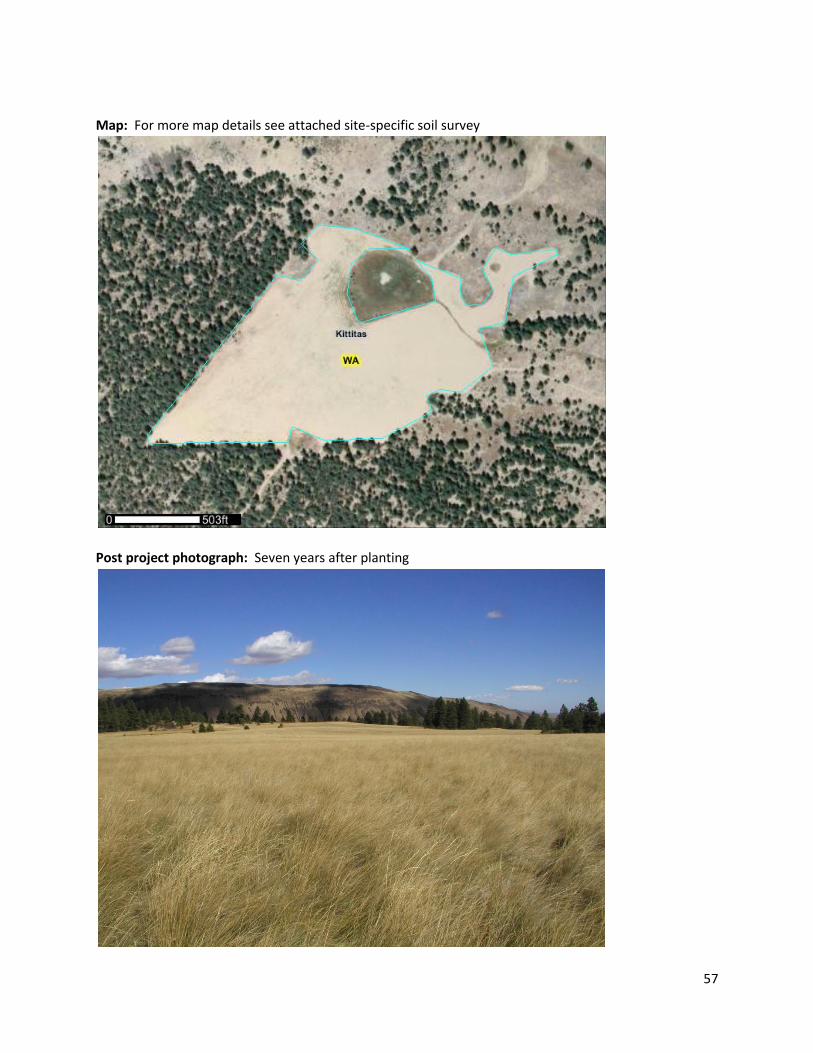
57
Map: For more map details see attached site-specific soil survey
Post project photograph: Seven years after planting
58
Central Ferry Canyon Field B Restoration Site Documentation
Recorded By: Marc Hallet
Date Recorded: 4/25/2011
Location and Site Attributes:
Project name/Year Central Ferry Canyon Field B - 1987
County Douglas
Location T 29N R24E S 03 Lat. 48.0375 Long. -119..8077
Wildlife area and Unit Wells WLA – Central Ferry Canyon
Supervising personnel M. Hallet, John Morris, J. Benson
Restored area size 42.2 ac.
Ownership WDFW
Elevation 1850-2020
Aspect NW
Slope ~6%
Annual Precipitation* 1987-2011 Average: 10.38” (6.75”-17.11”)
*http://prismmap.nacse.org/nn/index.phtml
Soils: Willock-Conconully complex, Chelan ashy fine sandy loam (See Table 1).
Adjacent land use and condition: Older CRP fields to the east have a serious infestation of Dalmatian toadflax. Dalmatian toadflax is now present on the site.
Site History: Dryland Wheat.
Project Goals: Revegetate wheat fields to shrub steppe habitat. Take advantage of resources provided by the CRP program.
Site Preparation: Wheat stubble. The fields had very few weeds and did not require any spraying, mowing or additional cultivation. (See Table 2, attached)
Seed Mix: We used two seed mixes in the 3-section drill: Part of the area was seeded with the grass/forb mix in two sections of the drill (16ft) and with the shrub/grass mix in the third (8 ft). (See Table 3a and 3b, attached)
Planting: (Table 4, attached)
Post-planting weed control and other management actions: (see Table 5, attached)
59
Evaluation of Current Conditions Date of status assessment: 04/25/201 (24 years after planting) Current Status: Overall, the seeding was relatively successful. The forb component is lacking however.
Dalmatian toadflax has encroached on the seeding especially in field E. We have limited our treatment
for this weed to biological agents (Mecinus janthinus).
Shrub/grass mix: Bitterbrush (Idaho source) did very well in this field and in about 2/3 of the area it was seeded elsewhere on the Central Ferry Canyon Unit. The four-wing saltbrush and seeded big sage had very poor success. This may have contributed to bitterbrush doing well. Too low a pH due to fertilizer use may have caused the failure of the saltbrush. Bitterbrush is slowly expanding into the neighboring grass strips. Over time, big sage spread onto the site from adjacent native stands.
Grass/forb mix: The forb component is extremely sparse. Goals realization: Generally, the goal of establishing “shrub steppe” was achieved. The diversity of
species on most of the site was relatively low due to poor establishment of the sagebrush, saltbrush and
forbs. The infestation of Dalmatian toadflax was unexpected. It is still manageable in this field. The
bitterbrush stand was especially good in this field.
Primary “lessons learned”: The bitterbrush stand was very successful on this site seeded at ½ seed per
square foot along with 13.4 seed/square foot of Sherman big bluegrass.
Special circumstances affecting outcomes: The seedbed was fairly weed-free at the time of seeding. Lower pH due to past farming activity may have caused poor four-wing salt brush establishment. Lack of sagebrush establishment may have been due to seed quality and/or seeding depth problems. Seeding depth with the no-till drill was difficult to regulate. Deeper planting of the shrub/grass mix may have caused poor Sherman big blue and sagebrush establishment giving the bitterbrush a competitive advantage. The shrub/grass seed mix was seeded in 8 ft rows adjacent to a grass/forb row 16 ft wide. Knowing that bitterbrush seedlings are poor competitors, the seed count was kept at a low 25 seed/square foot (PLS). Since the sagebrush and saltbrush seeding did not succeed, the effective seed count was around 13.4 seed/square foot. (12.9 for Sherman big bluegrass and 0.5 for bitterbrush). Keys to present level of success: The initial lack of weeds due to relatively good farming practices lead to successful establishment of many of the species seeded. The firm seedbed in wheat stubble also contributed to positive results. What could have been done differently: Include some bitterbrush in the grass-forb mix, use native species, increase diversity (shrubs/forbs/grass), replace Sherman with Sandberg (lower rate) and deleted tall wheatgrass. Project site future: No immediate plans. Consider inter-planting forbs and shrubs in the grass/forb strips to increase plant diversity and stand quality. If fire occurs, follow up with an inter-seeding of bitterbrush and forbs. A fire would remove the bitter brush component but would make inter-planting much easier. Inspect the site for noxious weeds and apply biological agents and herbicide as needed.
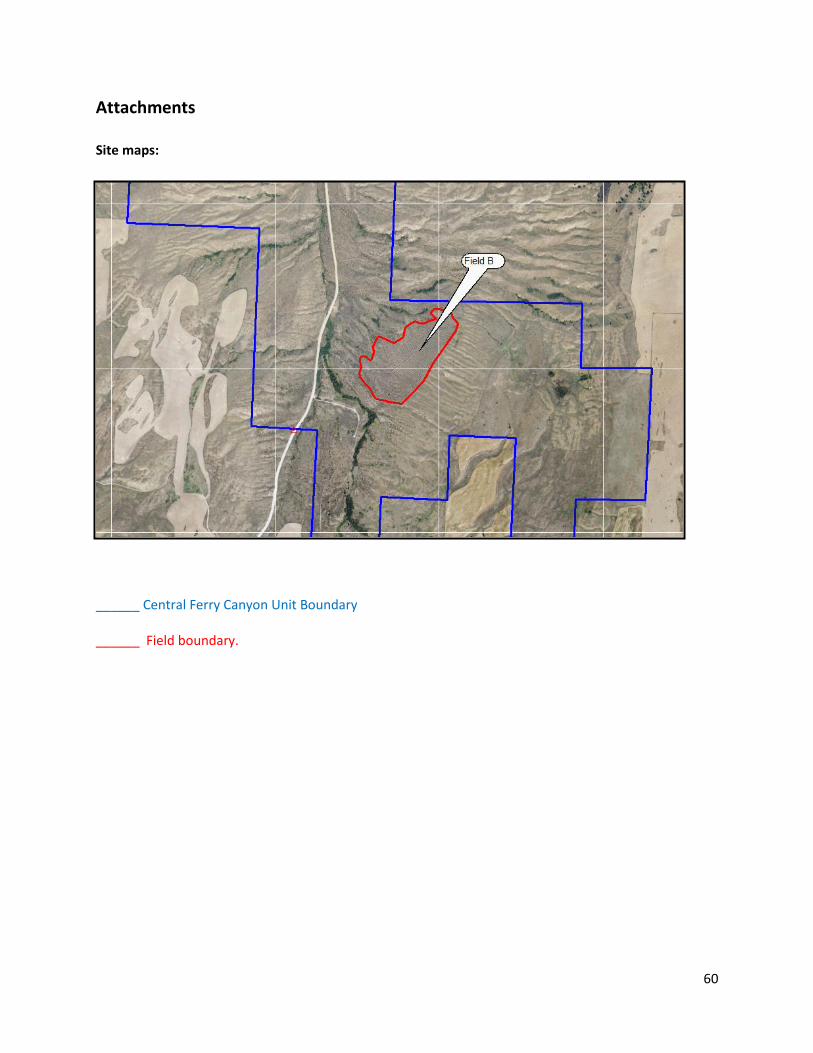
60
Attachments Site maps:
______ Central Ferry Canyon Unit Boundary ______ Field boundary.
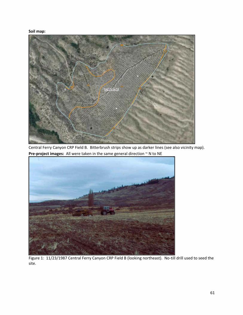
61
Soil map:
Central Ferry Canyon CRP Field B. Bitterbrush strips show up as darker lines (see also vicinity map).
Pre-project images: All were taken in the same general direction ~ N to NE
Figure 1: 11/23/1987 Central Ferry Canyon CRP Field B (looking northeast). No-till drill used to seed the site.
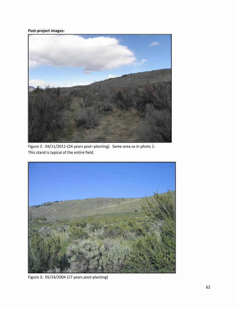
62
Post-project images:
Figure 2: 04/11/2011-(24 years post–planting). Same area as in photo 1.
This stand is typical of the entire field.
Figure 3: 05/14/2004 (17 years post-planting)
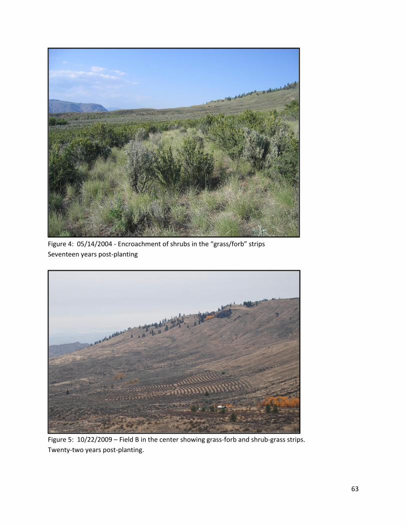
63
Figure 4: 05/14/2004 - Encroachment of shrubs in the “grass/forb” strips
Seventeen years post-planting
Figure 5: 10/22/2009 – Field B in the center showing grass-forb and shrub-grass strips.
Twenty-two years post-planting.
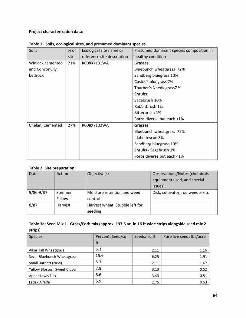
64
Project characterization data:
Table 1: Soils, ecological sites, and presumed dominant species
Soils % of
site
Ecological site name or
reference site description
Presumed dominant species composition in
healthy condition
Winlock cemented
and Conconully
bedrock
71% R008XY101WA
Grasses
Bluebunch wheatgrass 72%
Sandberg bluegrass 10%
Cusick’s bluegrass 7%
Thurber’s Needlegrass7 %
Shrubs
Sagebrush 10%
Rabbitbrush 1%
Bitterbrush 1%
Forbs diverse but each <1%
Chelan, Cemented
27% R008XY102WA Grasses
Bluebunch wheatgrass 72%
Idaho fescue 8%
Sandberg bluegrass 10%
Shrubs - Sagebrush 1%
Forbs diverse but each <1%
Table 2: Site preparation:
Date Action
Objective(s)
Observations/Notes (chemicals,
equipment used, and special
issues).
9/86-9/87
Summer
Fallow
Moisture retention and weed
control
Disk, cultivator, rod weeder etc
8/87 Harvest Harvest wheat. Stubble left for
seeding
Table 3a: Seed Mix 1. Grass/Forb mix (approx. 137.5 ac. in 16 ft wide strips alongside seed mix 2
strips)
Species Percent: Seed/sq
ft
Seeds/ sq ft Pure live seeds lbs/acre
Alkar Tall Wheatgrass 5.3 2.11 1.16
Secar Bluebunch Wheatgrass 15.6 6.25 1.91
Small Burnett (New) 5.3 2.11 1.67
Yellow Blossom Sweet Clover 7.8 3.13 0.52
Appar Lewis Flax 8.6 3.43 0.51
Ladak Alfalfa 6.9 2.75 0.53
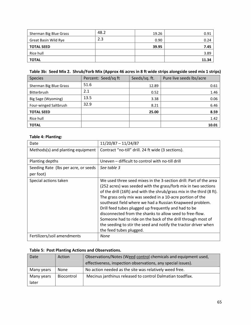
65
Sherman Big Blue Grass 48.2 19.26 0.91
Great Basin Wild Rye 2.3 0.90 0.24
TOTAL SEED 39.95 7.45
Rice hull 3.89
TOTAL 11.34
Table 3b: Seed Mix 2. Shrub/Forb Mix (Approx 46 acres in 8 ft wide strips alongside seed mix 1 strips)
Species Percent: Seed/sq ft Seeds/sq. ft. Pure live seeds lbs/acre
Sherman Big Blue Grass 51.6 12.89 0.61
Bitterbrush 2.1 0.52 1.46
Big Sage (Wyoming) 13.5 3.38 0.06
Four-winged Saltbrush 32.9 8.21 6.46
TOTAL SEED 25.00 8.59
Rice hull 1.42
TOTAL 10.01
Table 4: Planting:
Date 11/20/87 – 11/24/87
Methods(s) and planting equipment Contract “no-till” drill. 24 ft wide (3 sections).
Planting depths Uneven – difficult to control with no-till drill
Seeding Rate (lbs per acre, or seeds
per foot)
See table 3
Special actions taken We used three seed mixes in the 3-section drill: Part of the area (252 acres) was seeded with the grass/forb mix in two sections of the drill (16ft) and with the shrub/grass mix in the third (8 ft). The grass only mix was seeded in a 10-acre portion of the southeast field where we had a Russian Knapweed problem. Drill feed tubes plugged up frequently and had to be disconnected from the shanks to allow seed to free-flow. Someone had to ride on the back of the drill through most of the seeding to stir the seed and notify the tractor driver when the feed tubes plugged.
Fertilizers/soil amendments None
Table 5: Post Planting Actions and Observations.
Date Action
Observations/Notes (Weed control chemicals and equipment used,
effectiveness, inspection observations, any special issues).
Many years None No action needed as the site was relatively weed free.
Many years
later
Biocontrol Mecinus janthinus released to control Dalmatian toadflax.