case study monitoring-forest-fires-in-south-sumatra
TRANSCRIPT
The SETAPAK program promotes good forest and land governance as fundamental to achieving sustainable forest management, reducing greenhouse gas emissions, and supporting low carbon economic growth. Civil society has an important role to play in developing and maintaining good governance by providing oversight, and holding government to account. Citizen action and advocacy help ensure that environmental laws are enforced equitably, effectively and transparently.
With Singapore, Malaysia and Indonesia regularly suffering dangerous atmospheric pollution caused by illegal forest and land fires in Indonesia, SETAPAK partners have been using unmanned aerial vehicles to detect and monitor forest and peatland fires. Their objectives are to improve land management monitoring and law enforcement by reporting infractions and advocating for improved government regulation and response.
“Unmanned aerial vehicles provide affordable technology that allows us to monitor large areas quickly. They are particularly valuable when we need detailed information fast andif we need to inspect areas such as concessions that we are physically prevented from entering.”- Hadi Jatmiko, Director of WALHI South Sumatra.
Monitoring Forest Fires In South Sumatra
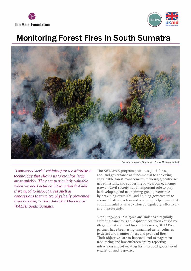
Forests burning in Sumatra | Photo: Muhammadiyah
Although Indonesian monitoring of forest fires is recognized as weak, late in the afternoon on June 25 2014, the National Board for Disaster Management (Badan Nasional Penanggulangan Bencana - BNPB) announced that 366 ‘hotspots’ – either fires, or areas that were likely to catch fire soon – had been detected across Sumatra’s Riau province, a steep increase on the 97 reported the previous day. With independent analysis suggesting over 800 hotspots, and the fires spreading rapidly despite the deployment of hundreds of firefighters, water bombing by helicopters, and cloud seeding to induce rain by the Indonesian air force, the event was beginning to look like a disastrous repeat of the fires in Sumatra in February that year, and in June the previous year.
The February outbreaks, which had peaked on March 2 when satellite images showed 1,234 hotspots spread across 5 regencies, had led to the declaration of an official state of emergency, and the hasty arrival of the president to supervise more than 3,000 firefighters and 10 aircraft. In the aftermath, with the costs of material losses estimated at US$1.2 billion, and those of the response at approximately US$12 million, 21,000 ha of drained and dried peat swamps had been razed.
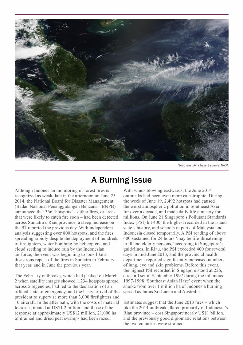
With winds blowing eastwards, the June 2014 outbreaks had been even more catastrophic. During the week of June 19, 2,492 hotspots had caused the worst atmospheric pollution in Southeast Asia for over a decade, and made daily life a misery for millions. On June 21 Singapore’s Pollutant Standards Index (PSI) hit 400, the highest recorded in the island state’s history, and schools in parts of Malaysia and Indonesia closed temporarily. A PSI reading of above 400 sustained for 24 hours ‘may be life-threatening to ill and elderly persons,’ according to Singapore’s guidelines. In Riau, the PSI exceeded 400 for several days in mid-June 2013, and the provincial health department reported significantly increased numbers of lung, eye and skin problems. Before this event, the highest PSI recorded in Singapore stood at 226, a record set in September 1997 during the infamous 1997-1998 ‘Southeast Asian Haze’ event when the smoke from over 1 million ha of Indonesia burning spread as far as Sri Lanka and Australia.
Estimates suggest that the June 2013 fires – which like the 2014 outbreaks flared primarily in Indonesia’s Riau province – cost Singapore nearly US$1 billion, and the previously good diplomatic relations between the two countries were strained.
A Burning Issue
Southeast Asia haze | source: NASA
Eyes In The Sky
For Peat’s SakeFundamental to the persistent fires in Riau is the fact that half of the province, over 4 million ha, is made up of deep peatland, much of which has been deforested and drained for agriculture or oil palm plantations. This makes the peat, which is essentially damp, dead vegetation, highly vulnerable to fire, and as seams often run long distances underground, fires in peatland areas can be very difficult to extinguish. Riau’s peat is unusually deep (up to 7.5 metres), which means both that it burns for longer, and is of high environmental value.
The destruction and burning of peatland has consequences beyond the dangers and costs of fire and atmospheric pollution. Peatlands, which cover about 3 percent of the earth’s land area, store around 500 billion metric tons of carbon, twice as much as is incorporated in the woodland in all the world’s forests. Globally, degraded peatlands emit nearly 3 billion tons of carbon dioxide annually, or roughly 6 percent of all greenhouse gas emissions from human activity. Drained peatland, of which there is around 65 million ha worldwide, is also likely to subside, meaning that drainage canals have to be dug deeper, exposing further seams of vulnerable peat.
Deforestation and drainage of peatlands, which underlie a significant proportion of the remaining undamaged forest areas in Indonesia, help make the country the third-largest emitter of greenhouse gases in the world. Indonesia’s carbon dioxide emissions from peat degradation are estimated at 1.9 billion metric tons per year, greater than those resulting from all the fossil fuel burnt nationally.
Remote controlled aircraft, called unmanned aerial vehicles (UAVs), provide affordable and labour saving means to carry out monitoring for conservation purposes as they allow large areas to be surveyed that would be difficult and time consuming to investigate on foot. UAVs carry cameras and video equipment that capture detailed images over ranges of up to 25 kilometres. SETAPAK NGOs are now beginning to experiment with UAVs to monitor deforestation and land use infractions.
SETAPAK partner WALHI (Wahana Lingkungan Hidup Indonesia - Indonesian Forum for Environment) South Sumatra has been trialling the use of UAVs to monitor timber concessions in South Sumatra’s OKI (Ogan Komering Ilir) regency, the proposed site for the world’s largest pulp mill. During the June 2014 fires, the organization first used online satellite images provided by WRI’s Global Forest Watch system to identify hot spots, and followed up with UAV flights and ground checks on 20,000 ha of concession areas to validate precisely where the fires were burning.
None of these catastrophic events were accidents. June is a period of relatively low rainfall in western Indonesia, commonly regarded as the start of the ‘fire season’, and national and international authorities were quick to declare that the fires were deliberately lit. The World Resources Institute (WRI) linked a number of the June 2014 fires to large paper and palm oil producers and their suppliers. Despite protestations
from the companies involved, which have stated no-burn, zero-deforestation policies, WRI used satellite images to detect 75 hotspots in Asia Pulp & Paper (APP) concessions in Riau, and a further 43 hotspots in areas occupied by suppliers to Asia Pacific Resources International Limited (APRIL). These companies are respectively Indonesia’s largest and second largest producers of pulp and paper products.
WALHI South Sumatra’s UAV flights revealed 80 cases of peatlands burning on concession areas, and the findings will be used as evidence in a legal case WALHI is bringing against the provincial government alleging negligence in monitoring and dealing with forest fires on concession areas. As well as advocating for improved monitoring, the organization is pressing for improved law enforcement.
WALHI South Sumatra was supported by SETAPAK partner SAMPAN, based in West Kalimantan. SAMPAN has been developing the skills to assemble low-cost UAVs from imported parts and fly them to monitor land based activities. The UAVs deployed in OKI regency include fixed-wing aircraft with spans of 1-2 metres, which are manually thrown into the air or launched using a catapult, and smaller rotary-wing quad-copters, which can take off and land vertically. Both types are powered by electric motors and lithium-ion batteries, which give flight times of around one hour.
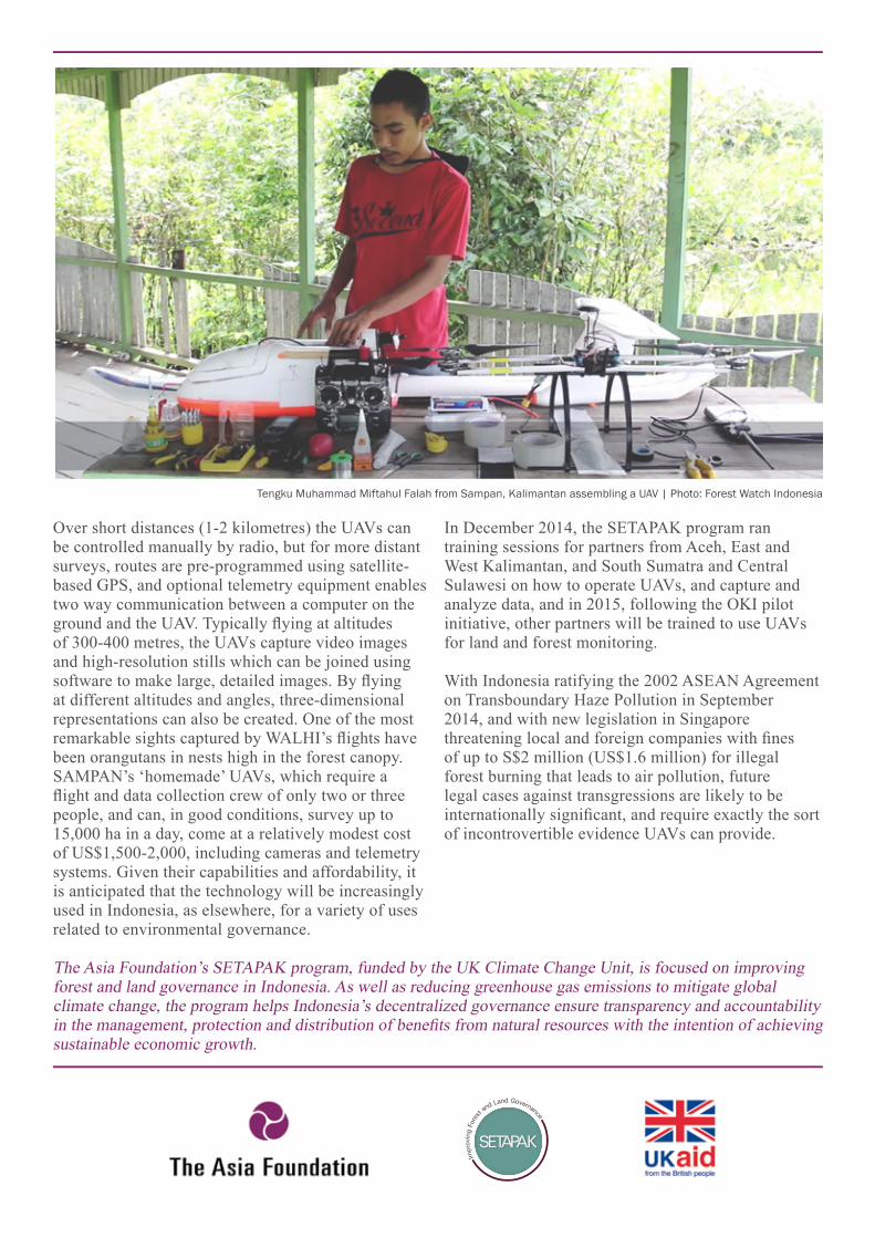
Over short distances (1-2 kilometres) the UAVs can be controlled manually by radio, but for more distant surveys, routes are pre-programmed using satellite-based GPS, and optional telemetry equipment enables two way communication between a computer on the ground and the UAV. Typically flying at altitudes of 300-400 metres, the UAVs capture video images and high-resolution stills which can be joined using software to make large, detailed images. By flying at different altitudes and angles, three-dimensional representations can also be created. One of the most remarkable sights captured by WALHI’s flights have been orangutans in nests high in the forest canopy.SAMPAN’s ‘homemade’ UAVs, which require a flight and data collection crew of only two or three people, and can, in good conditions, survey up to 15,000 ha in a day, come at a relatively modest cost of US$1,500-2,000, including cameras and telemetry systems. Given their capabilities and affordability, it is anticipated that the technology will be increasingly used in Indonesia, as elsewhere, for a variety of uses related to environmental governance.
Tengku Muhammad Miftahul Falah from Sampan, Kalimantan assembling a UAV | Photo: Forest Watch Indonesia
In December 2014, the SETAPAK program ran training sessions for partners from Aceh, East and West Kalimantan, and South Sumatra and Central Sulawesi on how to operate UAVs, and capture and analyze data, and in 2015, following the OKI pilot initiative, other partners will be trained to use UAVs for land and forest monitoring.
With Indonesia ratifying the 2002 ASEAN Agreement on Transboundary Haze Pollution in September 2014, and with new legislation in Singapore threatening local and foreign companies with fines of up to S$2 million (US$1.6 million) for illegal forest burning that leads to air pollution, future legal cases against transgressions are likely to be internationally significant, and require exactly the sort of incontrovertible evidence UAVs can provide.
The Asia Foundation’s SETAPAK program, funded by the UK Climate Change Unit, is focused on improving forest and land governance in Indonesia. As well as reducing greenhouse gas emissions to mitigate global climate change, the program helps Indonesia’s decentralized governance ensure transparency and accountability in the management, protection and distribution of benefits from natural resources with the intention of achieving sustainable economic growth.