causes of catastrophic flooding in bangladesh · causes of catastrophic flooding in bangladesh...
TRANSCRIPT
Causes of Catastrophic Flooding in Bangladesh
Conclusions: Bangladesh is a land of water that fosters a culture that is both susceptible to and reliant upon flooding. Damage and homelessness caused by recent floods continues to worsen; thus, Bangladesh must continue to develop its long-term strategy regarding flood control. Solutions: 1) Flood protection shelters (and evacuation plans); 2) Flood proof storage for food and grains; 3) Well built/situated artificial levees and coastal embankments; 4) Afforestation programs; 5. Regulations (limit building); 6. Early warning; 7) Post-flood aid; 8) Raising community awareness…
Figure 9: Prevailing Wind Model from GOES Satellite
Abstract - The annual rhythm of flooding in Bangladesh is natural, necessary, and welcome. Water molds the culture, shapes the land, and sustains all life; yet, it may also bring great destruction. Bangladesh is a country with scarce relief, large riparian floodplains, and extensive coastal lowlands. Remotely sensed space imaging of Bangladesh s Meghna River region provides a synoptic look into a unique landscape frequented by normal (barsha) and catastrophic (bonna) floods. An analysis comparing wet and dry monsoon images reveals that 40% of the land inundated with water returns to dry land during barsha flooding; while, as much as 70% of the land may be inundated during bonna floods. The principal causes of annual, normal flooding in Bangladesh are basin morphology, monsoon climate, and orographic effect. Catastrophic flooding is a consequence of a flood-prone landscape, coupled with cyclonic activity and poor (but often unavoidable) land use practices. Despite long-standing attempts to structurally control major flood events in Bangladesh, the discharge rate, extent, and severity of successive cyclonic flood is increasing. During the catastrophic floods of 1998, 2007, and 2012 alone, more than 42 million people in Bangladesh were affected. Many of those affected were forced into homelessness. Floods are intensified by poor land use practices. Rampant urbanization, deforestation, and agricultural clearing increase peak flows, creating favorable conditions for heightened flooding. Vegetation naturally impedes and absorbs runoff, thus reduces peak flood flows. Less than 10% of the forest cover remains in Bangladesh today.
Figure 1: Map of Bangladesh and Study Area
Figure 5: Climograph. Dhaka, Bangladesh s largest city and capital, is located in the northwest corner of the two main images. Peak precipitation for the Dhaka region occurs in July during the summer wet monsoon, when it receives 15.7 inches (39.89 centimeters). The least amount of rain occurs in December and January, coinciding with the winter dry monsoon core (see Figure 7.5). December and January experience 0.2 inches (.51 centimeters) and 0.3 inches (.80 centimeters) of rain respectively. Total average annual precipitation for Dhaka is 78.6 inches (199.64 centimeters).
The summer monsoon movement is well plotted in Figure 9, which was generated using data collected from a Geostationary Operational Environmental Satellite (GOES). GOES satellites are weather satellites that remain essentially fixed in orbit above the equator. The figure shows a 3-D perspective of flow during the South Asian wet monsoon in June. Arrows indicate near surface winds. The Himalayan Mountains and surrounding foothills impede and concentrate the northward flow of humid air and produce torrential orographic precipitation (see Figure 10). Low lying hills along the northern and eastern borders receive the greatest amounts of rainfall, as moist monsoonal air is uplifted and rapidly cooled. Cherrapunji is situated near the northern boarder of Bangladesh in India. It is the second rainiest location on Earth, after Mt. Waialeale, Hawaii. Cherrapunji receives 428 inches (1,087 centimeters) of rain per year and, amazingly, it experienced a world record 1,042 inches (2,645 centimeters) of rain in 1860. Runoff from orographic precipitation in the areas surrounding Bangladesh contributes to longstanding inundation in the lowland Meghna River region.
Figure 3: Satellite Image of the Lower Meghna River During the Wet Monsoon. An analysis comparing the monsoon flood image and the dry monsoon image (Figure 4) revealed that 40% of the land inundated with water returns to dry land. The total area covered by water in Figure 3 is 13% and the total area covered by water in Figure 4 is 53%. When the water recedes, numerous subchannels and slack water areas are exposed. Such features are identifiable on Figure 3 as barren sediment accumulation zones. The Padma/Meghna Rivers are notorious for their alluvial islands, called chars. Chars are formed and reworked during each year of flooding. People move onto the chars and take advantage of the fertile soils; however, the shifting nature and disappearance of these formations often lead to disastrous consequences. No permanent settlement should exist along the banks of these islands.
Purpose: 1) To determine the causes of flooding, 2) To resolve why the frequency and magnitude of bonna floods are increasing; and, 3) illustrate the tenacity & adaptability of the people of Bangladesh.
Tracy H. Allen, PhD, Chair, Department of Geography, Associate Professor of Geography and the Environmental Sciences Program, SUNY College at Oneonta
Physiographic Causes of Flooding
Anthropogenic Causes of (Increased) Flooding
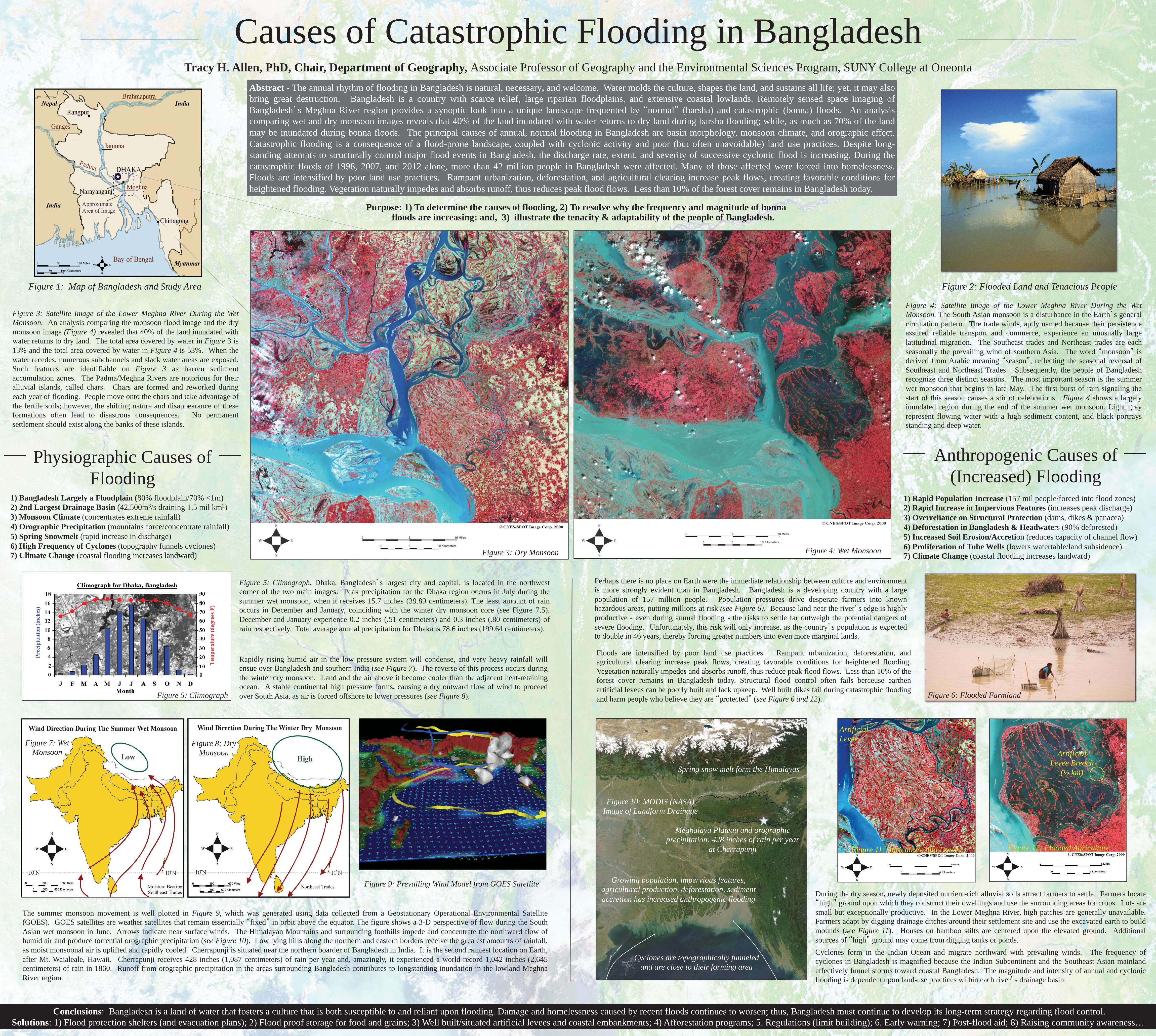
Figure 2: Flooded Land and Tenacious People
Rapidly rising humid air in the low pressure system will condense, and very heavy rainfall will ensue over Bangladesh and southern India (see Figure 7). The reverse of this process occurs during the winter dry monsoon. Land and the air above it become cooler than the adjacent heat-retaining ocean. A stable continental high pressure forms, causing a dry outward flow of wind to proceed over South Asia, as air is forced offshore to lower pressures (see Figure 8).
Figure 4: Satellite Image of the Lower Meghna River During the Wet Monsoon. The South Asian monsoon is a disturbance in the Earth s general circulation pattern. The trade winds, aptly named because their persistence assured reliable transport and commerce, experience an unusually large latitudinal migration. The Southeast trades and Northeast trades are each seasonally the prevailing wind of southern Asia. The word monsoon is derived from Arabic meaning season , reflecting the seasonal reversal of Southeast and Northeast Trades. Subsequently, the people of Bangladesh recognize three distinct seasons. The most important season is the summer wet monsoon that begins in late May. The first burst of rain signaling the start of this season causes a stir of celebrations. Figure 4 shows a largely inundated region during the end of the summer wet monsoon. Light gray represent flowing water with a high sediment content, and black portrays standing and deep water.
Floods are intensified by poor land use practices. Rampant urbanization, deforestation, and agricultural clearing increase peak flows, creating favorable conditions for heightened flooding. Vegetation naturally impedes and absorbs runoff, thus reduce peak flood flows. Less than 10% of the forest cover remains in Bangladesh today. Structural flood control often fails berceuse earthen artificial levees can be poorly built and lack upkeep. Well built dikes fail during catastrophic flooding and harm people who believe they are protected (see Figure 6 and 12).
Perhaps there is no place on Earth were the immediate relationship between culture and environment is more strongly evident than in Bangladesh. Bangladesh is a developing country with a large population of 157 million people. Population pressures drive desperate farmers into known hazardous areas, putting millions at risk (see Figure 6). Because land near the river s edge is highly productive - even during annual flooding - the risks to settle far outweigh the potential dangers of severe flooding. Unfortunately, this risk will only increase, as the country s population is expected to double in 46 years, thereby forcing greater numbers into even more marginal lands.
1) Bangladesh Largely a Floodplain (80% floodplain/70% <1m) 2) 2nd Largest Drainage Basin (42,500m3/s draining 1.5 mil km2) 3) Monsoon Climate (concentrates extreme rainfall) 4) Orographic Precipitation (mountains force/concentrate rainfall) 5) Spring Snowmelt (rapid increase in discharge) 6) High Frequency of Cyclones (topography funnels cyclones) 7) Climate Change (coastal flooding increases landward)
1) Rapid Population Increase (157 mil people/forced into flood zones) 2) Rapid Increase in Impervious Features (increases peak discharge) 3) Overreliance on Structural Protection (dams, dikes & panacea) 4) Deforestation in Bangladesh & Headwaters (90% deforested) 5) Increased Soil Erosion/Accretion (reduces capacity of channel flow) 6) Proliferation of Tube Wells (lowers watertable/land subsidence) 7) Climate Change (coastal flooding increases landward)
Meghalaya Plateau and orographic precipitation: 428 inches of rain per year
at Cherrapunji
Cyclones are topographically funneled and are close to their forming area
Growing population, impervious features, agricultural production, deforestation, sediment accretion has increased anthropogenic flooding
Spring snow melt form the Himalayas
Cyclones form in the Indian Ocean and migrate northward with prevailing winds. The frequency of cyclones in Bangladesh is magnified because the Indian Subcontinent and the Southeast Asian mainland effectively funnel storms toward coastal Bangladesh. The magnitude and intensity of annual and cyclonic flooding is dependent upon land-use practices within each river s drainage basin.
Artificial Levee Breach
(½ km)
During the dry season, newly deposited nutrient-rich alluvial soils attract farmers to settle. Farmers locate high ground upon which they construct their dwellings and use the surrounding areas for crops. Lots are
small but exceptionally productive. In the Lower Meghna River, high patches are generally unavailable. Farmers adapt by digging drainage ditches around their settlement site and use the excavated earth to build mounds (see Figure 11). Houses on bamboo stilts are centered upon the elevated ground. Additional sources of high ground may come from digging tanks or ponds.
Artificial Levee
Figure 6: Flooded Farmland
Figure 3: Dry Monsoon Figure 4: Wet Monsoon
Figure 5: Climograph
Figure 8: Dry Monsoon
Figure 7: Wet Monsoon
Figure 10: MODIS (NASA) Image of Landform Drainage
Figure 11: Agriculture and Levees Figure 12: Flooded Agriculture