cave hill station concept development report
TRANSCRIPT

Cave Hill Station Concept Development Report _________________________________________________________________________
Cave Hill Station Concept Development Report
RAYLINK CONSULTING
Prepared by Raylink Consulting
19th September 2017

Cave Hill Station Concept Development Report _________________________________________________________________________
Page | 1
EXECUTIVE SUMMARY
The proposed Cave Hill station site is located roughly half way between Mooroolbark station and Lilydale station adjacent to a proposed housing development site on the former Lilydale Quarry site. Victorian rail standards indicate that new stations must be located on straight track with a gradient no steeper than 1 in 200 (0.05%). At the old quarry site the only area with straight track and reasonably level track is directly opposite the old quarry pit (see map below). To achieve the 1 in 200 maximum gradient it will be necessary to carry out track lowering at the site.
The report compares the option of an island platform against side platforms and concludes that, at this location, an island platform layout is superior. The report provides a conceptual layout for the station as well as a longitudinal section, a cross section and an elevation view of the proposed station. The site of the station is on the single line section between Mooroolbark and Lilydale which is currently operating at capacity during peak periods. Introducing the new station will mean trains will have to stop within the single line section and this will reduce the Lilydale lines capacity. It will therefore be necessary to offset this capacity loss by means of:
constructing a crossing loop extending either side of the new station of sufficient length and configured to allow for simultaneous opposing direction arrivals and departures - requiring 300m signal overlap beyond the platform stopping point in each direction, or
fully or partially duplicate the track in conjunction with the introduction of the new station from Mooroolbark to Lilydale or from Mooroolbark to Cave Hill Down end (Lilydale end), or from Cave Hill Up end (Melbourne end) to Lilydale.

Cave Hill Station Concept Development Report
2 | P a g e
The estimated cost of the new station is approximately $13m. The estimated cost of the track lowering is approximately $5.5m and the estimated cost of the various track infrastructure options are:
Cave Hill crossing loop – approximately $28m Mooroolbark to Lilydale duplication - approximately $46m Mooroolbark to Cave Hill duplication - approximately $33m Cave Hill to Lilydale duplication – approximately $37m
Yarra Ranges Council strongly supports construction of the new station and is urging the State Government to commit to the timely construction of the necessary infrastructure works as a necessary enabler of the Cave Hill development project.

Cave Hill Station Concept Development Report
3 | P a g e
Table of Contents EXECUTIVE SUMMARY ...................................................................................................... 1
1. Purpose of Report .......................................................................................................... 4
2. Location of Station ......................................................................................................... 4
3. History and Current Train Operations .......................................................................... 4
5. Existing Conditions and Site Constraints .................................................................... 7
6. Type of Platform ............................................................................................................. 8
7. The Conceptual Cave Hill Station Scheme ................................................................. 10
8. Duplication alternatives ............................................................................................... 12
8. Cost Estimates ............................................................................................................. 15
9. Other Planned Rail Projects ........................................................................................ 22
10. Alternative Location for Station ................................................................................ 23

Cave Hill Station Concept Development Report
4 | P a g e
1. Purpose of Report The purpose of this report is to support and document the concept design and assessment of the proposed Cave Hill rail station between Mooroolbark and Lilydale. 2. Location of Station The proposed Cave Hill station site is located roughly half way between Mooroolbark station and Lilydale station. Cave Hill station will be integrated with the former Lilydale Quarry redevelopment site known as known as Cave Hill. Figure 1 below shows the location of the proposed station.
Figure 1. – Map showing general location of proposed Cave Hill station
3. History and Current Train Operations The railway from Camberwell to Lilydale was opened on 1 December 1882. The line beyond Croydon to Lilydale was electrified in October 1925 and track duplication reached the Melbourne end of Mooroolbark in September 1957. The duplicated track was extended to the Lilydale end of Mooroolbark in June 1985 and a second platform was provided for use by Lilydale bound trains. The Cave Hill siding to service the David Mitchell Estate was opened in March 1896. Until its closure in 1992, it was operated by means of a shunting trip with wagons pushed uphill by a locomotive

Cave Hill Station Concept Development Report
5 | P a g e
from Lilydale. The siding was primarily used for loading bagged lime which was railed state wide for agricultural use, although in later year’s bulk wagons were also loaded there. From a rail infrastructure perspective, the Lilydale line beyond Mooroolbark has seen little change since electric trains started operating there over 90 years ago. It remains a single line although it was re-equipped with remotely controlled colour light signalling in 1985. Probably its greatest change in that time has been the transition from a mixed traffic line, carrying steam and diesel-hauled passenger and freight trains, as well as electric suburban trains, to a pure suburban line only carrying passengers in electric trains. The current institutional arrangements for the infrastructure are that, in common with all railway land in Victoria, ownership of the Lilydale rail corridor is vested in VicTrack. All railway land used for current operations is leased from VicTrack to PTV (Public Transport Victoria). In turn, PTV sub-leases the various rail corridors to the respective infrastructure managers, in this case Metro Trains Melbourne which is a joint venture of the MTR Corporation of Hong Kong, UGL Rail (a Division of United Group limited) Limited and the John Holland Group. The MTM sub-lease, together with its train operating franchise, expires at the end of November 2017. On 12 September 2017 it was announced that the infrastructure sub-lease will be renewed for a further 7-year period, ending in November 2024. In common with its Infrastructure Lease, MTM is contracted to the Victorian Government to operate all metropolitan train services until 30 November 2017. The original MTM Franchise Agreement, which commenced on 1 December 2009, was for a term of 8 years with both parties having an option to negotiate a further term of 7 years. Negotiations for the Franchise Agreement extension had been underway for some time and on 12 September 2017 it was announced that the extension will be implemented, albeit with substantially more stringent performance requirements imposed by the Government. Lilydale train services are operated as an integral part of the Burnley Group of lines, which apart from Flinders Street to Lilydale, includes the lines from Ringwood to Belgrave, Camberwell to Alamein, Burnley to Glen Waverley and the Burnley Loop which is one of the four lines comprising the Melbourne Underground Loop. Currently, the Burnley Group fleet of trains is maintained at Epping Depot on the South Morang line, with supplementary maintenance functions also undertaken at the smaller Bayswater Depot on the Belgrave line. Burnley Group metropolitan trains are stabled overnight at designated locations, of which two of the most important are at Ringwood and Lilydale. Ringwood sidings can accommodate 12 trains while Lilydale sidings can hold up to 10 trains. Weekday peak period services to Lilydale run on average every 15 minutes, increasing to every 10 minutes in the busiest hour. At other times, current timetabled services are generally based around the concept of providing alternate services to and from the Lilydale and Belgrave lines so that the service frequency doubles between Ringwood (where the two lines converge) and the Melbourne CBD. For example,
Weekday off-peak services run every 30 minutes (15 minutes CBD to Ringwood)
Weekday evening services run every 30 minutes with alternative services running direct
from the CBD and operating as a shuttle service between Ringwood and Lilydale
Weekend services until 8pm run every 20 minutes (10 minutes CBD to Ringwood)
Weekend evening services after 8pm run every 30 minutes (15 minutes CBD to Ringwood).
The single line beyond Mooroolbark generally operates at maximum capacity during peak periods with trains turning around at Lilydale in the minimum practicable time of 5-6 minutes. To maximise services beyond Ringwood, three AM peak services turn back at Mooroolbark and one PM peak service turns back at Mooroolbark. Two of the three AM peak Mooroolbark services originate from the Ringwood stabling sidings and the PM peak service returns to Ringwood to stable.

Cave Hill Station Concept Development Report
6 | P a g e
4. Operational Implications of a New Cave Hill Station A new station on the single line section between Mooroolbark and Lilydale will add at least one minute to train running times in each direction. While this does not sound very significant, the combined effect will be to increase the train occupancy time, inclusive of signal clearance times for opposing train movements at both Mooroolbark and Lilydale, from 9 to 11 minutes. This is equivalent to a 15% reduction in the peak period capacity of that line section. Because this section of line is already operating at its maximum practicable capacity during weekday peak periods, it is certain that the introduction of a new station at Cave Hill will also necessitate infrastructure enhancement in the form of either a long crossing loop or further line duplication to offset the capacity impact. As a minimum, this would imply a suitably configured Cave Hill crossing loop at least 1km in length or an extension of track duplication from Mooroolbark to the Lilydale end of Cave Hill station or from the Mooroolbark end of Cave Hill station to Lilydale. However the desired practical outcome from an operational perspective would be to complete the duplication all the way to Lilydale. During consultation PTV has indicated that full duplication is the solution that would be supported. A suitably configured crossing loop would neutralise the additional time involved in a Cave Hill station stop but would not increase the overall capacity of the Mooroolbark to Lilydale line section. Even though the crossing loop would be designed and signalled to allow simultaneous arrivals and departures, this cannot be scheduled in practice without allowing a minimum of two minutes additional dwell time for one of the two opposing trains that would meet at Cave Hill. This is to absorb normal minor variations in operational performance. To the extent permitted by overall scheduling constraints on the Ringwood corridor, the additional dwell time would normally be applied in the counter-peak direction. Within the metropolitan area, new crossing loops on single line sections are no longer favoured, largely because they do little to aid overall reliability and resilience of the network. The partial duplication options would increase overall line section capacity to the extent to which the existing single line sections are shortened but the underlying impact of any remaining single line sections on network reliability and operating resilience remains. Anecdotally, it is also reported that some peak period Lilydale trains are fairly regularly terminated short of the full journey at Mooroolbark due to late running and the restricted capacity of the single line to Lilydale. This is highly frustrating for regular commuters. Full duplication of the Mooroolbark to Lilydale line section will provide a theoretical large increase in capacity but in practice, only a small proportion of the capacity increase is useable because of capacity constraints on the Melbourne side of Ringwood. In practice, full duplication to Lilydale would allow several services which currently terminate at Ringwood or Mooroolbark to be extended to Lilydale, however it is questionable as to whether this would be supported by demand. It would also affect the balance of trains stabled at Ringwood and Lilydale. A more likely scenario is that the three AM services which currently originate at Mooroolbark (at 7.02am, 7.31am and 8.03am) would instead originate at Lilydale. Similarly, the sole PM Mooroolbark service (5.13pm from Flinders Street) would be extended to Lilydale. This would also affect the balance of stabling between Ringwood and Lilydale and most likely be a driver for additional stabling capacity at Lilydale. Overall, it can be argued that introduction of a Cave Hill station stop and its associated train dwell time of 20-30 seconds will be the proverbial “straw that breaks the camel’s back” of the line capacity and hence should be the driver for extending the duplicated track beyond Mooroolbark. However, it can be equally argued that there has long been a policy of progressively eliminating all single line sections in the metropolitan network as these are a prime contributor to service unreliability, quite

Cave Hill Station Concept Development Report
7 | P a g e
apart from the large network capacity gains that track duplication provides. In this particular case, track duplication beyond Mooroolbark to Lilydale is listed as a future requirement in the 2012 PTV Network Development Plan – Metropolitan Rail, so that the only possible argument of substance could be that the new station will have brought forward the required timing of the duplication works. Other factors which may also influence the timing of duplication beyond Mooroolbark could be the provision of additional train stabling and possibly a train maintenance facility at Lilydale (see Section 9, below) and/or the proposed works to grade separate the Maroondah Highway level crossing at Lilydale. 5. Existing Conditions and Site Constraints There are two significant constraints to be dealt with in selecting the precise location for the new station. The first issues is the existing track gradient and the second issue is the track curvature. On its approach to the Cave Hill station site the rail line climbs at a 1 in 40 gradient which is the maximum allowable grade for suburban electrified rail lines. At the site, the rail line has a vertical summit curve and then begins to descend towards Lilydale in another 1 in 40 gradient. The grade line is shown below in figure 2 below which is an extract from the old Victorian Railways curves and gradients book.
Figure 2. – Extract Victorian Railways curves and gradients book Current standards dictate that station platforms are to be located on gradients no greater than 1 in 200. It will therefore be necessary to regrade the rail line at the crest in order to stay within the 1 in 200 gradient limit. This regrading is shown as a dotted red line in figure 2. On the issue of track curvature, current rail standards in Victoria specify that any new station platforms are to be located on a straight section of track. Fortunately the section of track where the crest is located is on a section of straight track between the two curves. Figure 3 below shows the section of straight track next to the old quarry pit where the station will be located.

Cave Hill Station Concept Development Report
8 | P a g e
Figure 3. – Map showing section of straight track for locating Cave Hill station It is understood that the old quarry pit will be filled in a manner that will allow buildings to be constructed on the filling. Therefore the new station will eventually be surrounded by development. 6. Type of Platform The existing single track between Mooroolbark and Lilydale will eventually be duplicated so this means there is a choice between building a single “island platform” between the two tracks or building two “side platforms”. The two options are shown diagrammatically below in figure 4.

Cave Hill Station Concept Development Report
9 | P a g e
Figure 4. – Island platform and side platform diagrams Experience from designing stations at other locations has shown that it is generally more economical to construct a single island platform in locations such as this one where the second track is yet to be constructed. This may not have been the case if there was already two tracks because at least one of the tracks and associated overhead structures/wiring would have had to be relocated to make a space between the tracks that is wide enough to fit the island platform. In other words, it is more economical at this location to build a single island platform rather than two side platforms. The other issue that makes the island platform the best choice at Cave Hill is the issue of construction staging. Figure 5 below diagrammatically shows a cross section of the existing track in black and the future lowered and duplicated tracks with side platforms in red.
Figure 5. – Side platform cross sectional diagram Obviously the rail line would have to be shut down for a number of weeks to build the lowered tracks and side platforms and this would be inconvenient for rail customers and would also be very costly to construct. Figure 6 below diagrammatically shows a cross section of the existing track in black and the future second track with an island platform in red.

Cave Hill Station Concept Development Report
10 | P a g e
Figure 6. – Island platform cross sectional diagram A temporary fence can be erected at the clearance point next to the existing track and most of the island platform, ramps and station building can be constructed clear of the existing operating rail line. The section of the platform immediately adjacent to the existing track can be built in conjunction with the rail system shut down required to lower the existing track, or subsequently after the existing track is dismantled
7. The Conceptual Cave Hill Station Scheme A concept design has been prepared for Cave Hill station. The concept design includes a locality plan view of the station and adjacent track alignment, a longitudinal section, a cross section and an elevation view. A locality plan view of the station and adjacent track alignment is shown in figure 7.
Figure 7. – Locality plan of the proposed Cave Hill station

Cave Hill Station Concept Development Report
11 | P a g e
An extract from the longitudinal section is shown in figure 8.
Figure 8. – Longitudinal section extract showing track lowering (regrading) The track lowering occurs over a distance of approximately 500m. The start and finish points of the track lowering are indicated by the dots near the sides of the diagram. The station cross section is shown in figure 9.
Figure 9. – Extract from cross section of station The station elevation view is shown in figure 10.
. .

Cave Hill Station Concept Development Report
12 | P a g e
Figure 10. – Station elevation view
8. Duplication alternatives As indicated earlier in this report, during the course of the investigations, a request was received to undertake a high level assessment of alternatives to track duplication. To that end a crossing loop conceptual plan was developed. An extract from the crossing loop concept plan is shown below in figure 11 which is in two sections in order to provide clarity.

Cave Hill Station Concept Development Report
13 | P a g e

Cave Hill Station Concept Development Report
14 | P a g e
Figure 11. – Extract from conceptual crossing loop plan

Cave Hill Station Concept Development Report
15 | P a g e
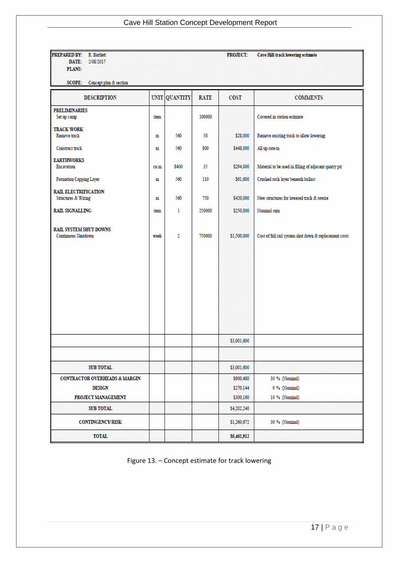
Turnouts need to be located on straight tracks. Therefore, at this location, the crossing loop is longer than it would need to be if the tracks were straight. As can be seen in figure 11, the turnouts have been located on the first section of straight track at both ends of the station site. The concept plan is included as an appendix of this report. 8. Cost Estimates Separate itemised cost estimates have been prepared for the Cave Hill station, the track lowering and the track duplication between Mooroolbark and Lilydale stations. Cave Hill station is estimated to cost approximately $13m to construct, the track lowering is estimated to cost around $5.5m and the full track duplication is estimated to cost approximately $46m. It was difficult to estimate the cost of track duplication at Lilydale as we do not know what the track layout will look like after the Maroondah Highway level crossing is removed. It would be prudent to reassess the estimate when the Level crossing Removal Authority has released its final plan for the grade separation and associated rail yard modifications. As part of the additional request to evaluate loop alternatives addition cost estimates were also prepared. The estimated cost of a crossing loop at Cave Hill is approximately $28m, the estimated cost of Mooroolbark to Cave Hill duplication is approximately $33m and the estimated cost of Cave Hill to Lilydale duplication is approximately $37m All of the itemised cost estimates are shown in figures 12 to 17.

Cave Hill Station Concept Development Report
16 | P a g e
Figure 12. – Concept estimate for Cave Hill station
Cave Hill Station Concept Development Report
17 | P a g e
Figure 13. – Concept estimate for track lowering

Cave Hill Station Concept Development Report
18 | P a g e
Figure 14. – Concept estimate for track duplication from Mooroolbark to Lilydale

Cave Hill Station Concept Development Report
19 | P a g e
Figure 15. – Concept estimate for Cave Hill crossing loop

Cave Hill Station Concept Development Report
20 | P a g e
Figure 16. – Concept estimate for track duplication to Cave Hill

Cave Hill Station Concept Development Report
21 | P a g e
Figure 14. – Concept estimate for track duplication from Cave Hill to Lilydale

Cave Hill Station Concept Development Report
22 | P a g e
9. Other Planned Rail Projects Because infill housing development in the eastern suburbs has been largely completed for many years and residential densification in this part of Melbourne is still at an early stage, population growth on the Burnley Group of lines is occurring at a slower rate than in many other parts of Melbourne. The Burnley group is made up of:
The Lilydale line
The Belgrave line
The Alamein line
The Glen Waverley line This slower than average growth is reflected in the relatively slower patronage growth of about 2% per annum on the Burnley Group of lines compared with much faster growth elsewhere on the metropolitan network. As such, there are no current plans for major works, for example, for capacity enhancement, to be undertaken on the Burnley Group within the short to medium term. In this context, it should be noted that the multi-billion dollar Melbourne Metro project has as its principal objective, major capacity enhancement on all other lines, apart from the Burnley and Clifton Hill Groups of lines, the latter comprising the lines to South Morang and Hurstbridge. However, some less significant works are planned to occur on the Burnley Group that will allow for maximum utilisation of the existing infrastructure. The most important of these is the planned re-arrangement of the Burnley Rail Junction layout which presently restricts the free flow of trains through that location in the counter-peak direction at peak periods. Because of the three-track configuration between Burnley and Box Hill which, by means of the bi-directional centre track involves the use of two tracks in the peak flow direction, and because all Burnley Group trains either circulate through the underground loop or turn back at Flinders Street, the ultimate constraint on the Group’s operational capacity is the one remaining track to accommodate the counter-peak flow. The current Burnley layout will enable the counter-peak flow, particularly in the more concentrated AM peak, to be streamlined, thus enabling the operation of one or two additional services in the busiest hour. This work is expected to be undertaken during the next five to ten years. Within 10 years, or soon thereafter, it is likely that duplication from Mooroolbark to Lilydale will be required, partly driven by the need to increase stabling capacity at Lilydale to absorb the additional trains facilitated by the Burnley Junction works. This is important because there are no other suitable or available sites on the Burnley Group lines that can be expanded to accommodate additional trains. It is also possible that a new maintenance facility may be provided at Lilydale in the future which would eliminate the need for Burnley Group trains to access the Epping facility, a process which is relatively inefficient and costly. This will depend on whether a suitable site can be found for this purpose at Lilydale, with an extension to Coldstream an outside possibility if this proves to be impracticable. Longer term, and almost certainly beyond 15 years, it is planned to provide a fourth track between Burnley and Camberwell and to create a separate operation for trains on the Glen Waverley and Alamein lines from those operating to Ringwood and beyond. This is wholly dependent on other proposals for expanding the capacity of the rail network through the inner core of Melbourne’s rail network.

Cave Hill Station Concept Development Report
23 | P a g e
10. Alternative Location for Station During the course of the investigations a request was received to determine if it would be practical
to move the station location further east so that it would be close the abandoned quarry processing
plant. Figure 14 below indicates that this could be achieved, however it would mean the rail line
would have to be moved southward by up to 20m and would also require considerable additional
track lowering.
Figure 14. – Conceptual layout for alternative station location
The longitudinal section for the alternative station location is shown in figure 15.
Figure 15. – Conceptual longitudinal section for alternative station location

Cave Hill Station Concept Development Report
24 | P a g e
Appendix 1
Cave Hill Station Concept Layout and Sections

Cave Hill Station Concept Development Report
25 | P a g e
Appendix 2
Cave Hill Crossing Loop Concept Plan