cdot configuration readme introduction · cdot configuration readme.pdf • cdot menu help...
TRANSCRIPT
CDOT Configuration ReadMe
V03.02.03 Page 1 of 45 August 18th, 2008
Introduction This Read Me has been divided into the following sections.
New Features – Default Project Directory Documentation Custom Programs InRoads Preferences Storm & Sanitary Survey Preferences MicroStation Configuration Cell Libraries Level Libraries Seed Files Plotting Known Issues
New Features Version 03.02.03 August 18, 2008 This release implements the following enhancements and fixed problems that have been reported during production. Updates made to Documentation for additional workflows, Custom Programs for Menu update/fix, MicroStation Configuration, and plotting. Default Project Directory Custom Programs
• CDOT Menu o Modified ROW Survey (Cell) menu items that were labeled Line to Monument
or Control Renamed Government (PLSS) – Quarter Section Line (Cell) to Quarter
Section Monument Renamed Government (PLSS) – Section Line (Cell) to Section
Monument Renamed Government (PLSS) – Sixteenth Section Line (Cell) to
Sixteenth Section Monument Renamed ROW – ROW Line (Cell) – ROW Control
o Modified Bridge menu items that were not finding correct levels Type: Center > Center-Arches-Pins Type: Center > Center-Arches-Diaphragms Type: Center > Center-Stringer Type: Center > Outline-Stringer
CDOT Configuration ReadMe.pdf
InRoads Preferences Survey Feature Table
• Updated InRoads Survey Feature Table for code 3279 Controller Cabinet to select new cell name TRAF_CONTROLLER-Cabinent_exist from the TOPO.cel file.
• Updated InRoads Survey Feature Table for code 4283 Telephone Booth to select new cell name MISC_Telephone-Booth_exist from the TOPO.cel file.
Preferences
• Updated InRoads Prefernce T_Controller Cabinet to select new cell name TRAF_CONTROLLER-Cabinent_exist from the TOPO.cel file.
• Updated InRoads Prefernce T_Tel Booth to select new cell name MISC_Telephone-Booth_exist from the TOPO.cel file.
• A new Staking Report (CDOT_StakingReport.xsl) has been made and added to the XML style sheets for Stakeout
MicroStation Configuration
• The following project template files have had their border line work updated o JPC#DES_EarthworkQuant##.dgn o JPC#DES_GenNote##.dgn o JPC#DES_PLAN##.dgn o JPC#DES_PnP##.dgn o JPC#DES_Prof##.dgn o JPC#DES_SAQ##.dgn o JPC#DES_StdPlanList.dgn o JPC#DES_SWMP.dgn o JPC#DES_TabConc##.dgn o JPC#DES_TabMisc##.dgn o JPC#DES_TabRem##.dgn o JPC#DES_TyplSect##.dgn o JPC#SURV_Tab.dgn o JPC#HYDR_StrQuant##.dgn o JPC#TRAF_Schedule##.dgn o JPC#TRAF_TabPvmtMrk##.dgn o JPC#TRAF_TabSigns##.dgn
Cell Libraries
• TRAF_SIGNS.cel o Modified the MPH text on cell FHWA_w1-1al enabling it to be edited. o Modified the MPH text on cell FHWA_w1-1ar enabling it to be edited.
• GENERAL.cel o Modified Cell SHEET_Design-Sheet. Increased the line weight on the line below
the words “PLAN SHEET” o Deleted cell SHEET_Region-Mark-Mueller o Added cell SHEET_Region-Travis-Miller o Deleted cell SHEET_Region-Dave-Martinez o Added cell SHEET_Region-Glenn-Frieler
• TOPO.cel
V03.02.03 Page 2 of 45 August 18th, 2008
CDOT Configuration ReadMe.pdf
o Created new cell TRAF_CONTROLLER-Cabinent_exist for survey code 3279. o Created new cell MISC_Telephone-Booth_exist for survey code 4283.
Level Libraries • Bridge.dgnlib
o Changed symbology on BRDG_TOOLS_Center-Arches-Diaphragms to co=81, ls=4, wt=0
o Added level Default to all Bridge filters o Fixed misspelling on BRDG_TOOLS_Outline-AntiIcing
Plotting
• CDOT-PenTable.tbl o Adjustments have been made so that the Annotation in Existing signs plots in
grey. o Fixed misspelling on Brdg_TOOLS_Outline-AntiIcing
Known Issues
• While running the Typical Section Program, if a user runs the Fit View or Window Area window command and then attempts to place a typical section, nothing will happen until the reset button (right button) on the mouse has been selected. Typical Sections can only be placed when the MicroStation cursor is not showing a horizontal/vertical X (what looks like a plus symbol).
V03.02.03 Page 3 of 45 August 18th, 2008
CDOT Configuration ReadMe.pdf
Introduction This Read Me has been divided into the following sections.
New Features – Default Project Directory Documentation Custom Programs InRoads Preferences Storm & Sanitary Survey Preferences MicroStation Configuration Cell Libraries Level Libraries Seed Files Plotting Known Issues
New Features Version 03.02.02 June 2, 2008 This release implements the following enhancements and fixed problems that have been reported during production. Updates made to Documentation for additional workflows, Custom Programs for Menu update/fix, MicroStation Configuration, and plotting. Default Project Directory
• Changed the following drawings in \ROW_Survey\Drawings\Reference_Files from 3D to 2D.
o JPC#ROW_Model.dgn o JPC#SURV_Model.dgn
• Changed the following drawings in \Workspace-CDOT\Project Template\ROW_Survey\Drawings from 3D to 2D. Additionally, level assignments for vertical lines in the title blocks have been assigned to the correct level and the $Plot_Info$ variable was updated to new location next to border line work.
o JPC#ROW_Cnty-24x18_##.dgn o JPC#ROW_Cnty-24x36_##.dgn o JPC#ROW_Mon##.dgn o JPC#ROW_Ownership##.dgn o JPC#ROW_Plan##.dgn o JPC#ROW_TabProp##.dgn o JPC#ROW_TabProp01.dgn o JPC#ROW_TabProp02.dgn o JPC#ROW_TabProp03.dgn o JPC#ROW_TabProp04.dgn o JPC#ROW_TitleSht.dgn o JPC#SURV_MonRcrd##.dgn o JPC#SURV_Plan LSCD##.dgn o JPC#SURV_PlanPCD##.dgn
V03.02.03 Page 4 of 45 August 18th, 2008
CDOT Configuration ReadMe.pdf
o JPC#SURV_TitleLSCD##.dgn o JPC#SURV_TitlePCD##.dgn
• Made the following changes to drawings in \Workspace-CDOT\Project Template\ROW_Survey\Drawings
o Revision dates were expanded to include mm/dd/yy from mm/yy. o Last mod date was revised from 00-00-00 to mm-dd-yy. o RW prefix was dropped from sheet numbers o The second ‘Project Location’ label was removed from the top-right title block.
The XXX text for replacement was left in the title. o The word ‘Sheet’ was removed from ‘Subset Sheet’ in the title block
JPC#SURV_PlanLSCD##.dgn JPC#SURV_TitleLSCD##.dgn JPC#SURV_PlanPCD##.dgn JPC#SURV_TitlePCD##.dgn JPC#ROW_Mon##.dgn JPC#ROW_Ownership##.dgn JPC#ROW_Plan##.dgn JPC#ROW_TabProp##.dgn JPC#ROW_TabProp01.dgn JPC#ROW_TabProp02.dgn JPC#ROW_TabProp03.dgn JPC#ROW_TabProp04.dgn JPC#ROW_TitleSht.dgn
• Added a scale bar to the following files in \Workspace-CDOT\Project
Template\ROW_Survey\Drawings o JPC#ROW_Plan##.dgn o JPC#ROW_Ownership##.dgn
• Resized the survey statement signature blocks in \Workspace-CDOT\Project Template\ROW_Survey\Drawings
o JPC#ROW_Mon##.dgn
• Rewrote the instructions (included in the dgn file) for using the linked Excel tab sheets for files JPC#ROW_TabProp01.dgn, *02.dgn, *03.dgn, and *04.dgn
• Changed the title of the linked Excel workbook on \Workspace-CDOT\Project
Template\ROW_Survey\Drawings\Tabs JPC#ROW_TabMon.xls
• Changed the border of the Excel file to a lighter line-weight (plotted to heavy) in \Workspace-CDOT\Project Template\ROW_Survey\Drawings\Tabs\JPC#ROW_TabProp.xls
Documentation
• Workflow manual “CDOT Using Curb Ramps Cells.pdf” updated with new and updated Curb Ramp Cells.
V03.02.03 Page 5 of 45 August 18th, 2008
CDOT Configuration ReadMe.pdf
• CDOT Menu help documents were updated to match the latest configuration release
03.02.02 • Workflow documents were updated to match the directory structure, file naming
convention, and workflows for configuration release 03.02.02 Custom Programs
• CDOT Menu o Fix made to Active Angle setting prohibiting non-valid inputs. o Added new ITS Devices o Modified ITS Conduit menu “ITS Conduit” to use
TRAF_ITS_Conduit_Proposed level. o Added “General Conduit” to Traffic ITS Conduit menu o Added new Approach cells to Bridge Cells menu Type Miscellaneous.
• Accident.mvba o Annotation fixes have been made to the justification settings to fix problem with
text not staying on one page. • New “County Sheet Composer” program added to CDOT Tools pulldown • New “Levels Off” program added to CDOT Tools pulldown • PlaceBreaks.mvba replaced with PlaceBreak.ma • Roughen.mvba replace with Roughen.ma
InRoads Preferences
• Updates to the CDOT –Survey_Features.fwf file were made to feature codes 1065, 1070, and 1075.
• Updates have been made to the XML style sheets for legal descriptions • Added 2004 AASHTO Super-elevation tables;
MicroStation Configuration
• Active Angle From 2 Points button added to Misc Tools tool box. • Added the Specl13.shx to the AutoCAD Commands folder • Bridge.cel updated
o Added cell misc_ApproachSketch-Curve o Added cell misc_ApproachSketch-Tangent
• General.cel update o Modified Ed Martinez cell o Modified Martha Millers cell o Added Ali Imansepahi cell o Added cell ATR-Station o Added cell Advisory-Radio o Added cell Antenna o Added cell CCTV o Added cell Blank-Out-Sign o Added cell Camera
V03.02.03 Page 6 of 45 August 18th, 2008
CDOT Configuration ReadMe.pdf
o Added cell CDOT-Maintenance-Yard o Added cell Message-Sign o Added cell Multiplexer o Added cell CDOT-Node-Building o Added cell Ramp-Meter o Added cell Spectrum-Radio o Added cell Traffic-Signal o Added cell Transceiver o Added cell Vehicle-Detector o Added cell Warning-Sign o Added cell Weather-Info-System o $Plot_Info$ text moved on SHEET_Design-PnP-Sheet cell o $Plot_Info$ text moved on SHEET_Design-Profile-Sheet cell o $Plot_Info$ text moved on SHEET_Design-Sheet cell o $Plot_Info$ text moved on SHEET_Design-Typical-Section-Sheet cell o $Plot_Info$ text moved on SHEET_ SURV-PCD-Title-Sheet o $Plot_Info$ text moved on SHEET_ SURV-PCD-Plan-Sheet o $Plot_Info$ text moved on SHEET_ SURV-Monument-Record-Sheet o $Plot_Info$ text moved on SHEET_ SURV-LSCD-Title-Sheet o $Plot_Info$ text moved on SHEET_ SURV-LSCD-Plan-Sheet o $Plot_Info$ text moved on SHEET_ ROW-Title-Sheet o $Plot_Info$ text moved on SHEET_ ROW-Tab-of-Properties-Sheet o $Plot_Info$ text moved on SHEET_ ROW-Plan-Sheet o $Plot_Info$ text moved on SHEET_ ROW-Ownership-Sheet o $Plot_Info$ text moved on SHEET_ ROW-Monumentation-Sheet o $Plot_Info$ text moved on SHEET_ ROW-County-24x36 o $Plot_Info$ text moved on SHEET_ ROW-County-24x18 o Added a scale bar to SHEET_ROW-Plan-Sheet cell o Added a scale bar to SHEET_ROW-Ownership-Sheet cell o Resized the survey statement signature blocks in SHEET_ROW-Monumentation-
Sheet
• Hydraulics.cel update o Changed cell origin point on INLET_TY-R-L5 to station point location o Changed cell origin point on INLET_TY-R-L10 to station point location o Changed cell origin point on INLET_TY-R-L15 to station point location
• Road_Design.cel update o Added cell DES_XSEC_Curb-Type-6(M)-(CONCRETE) o Added cell DES_XSEC_Curb-Type-6(M)-(BITUMINOUS) o Added cell DES_XSEC_Curb-and-Gutter-TYPE-2(MS) o Added cell DES_XSEC_Curb-and-Gutter-Type-2(IIB) o Added cell DES_XSEC_Curb-Type-2(B) o Added cell DES_XSEC_Curb-and-Gutter-Type-2(IB) o Added cell DES_XSEC_Curb-Type-2(M) o Added cell DES_XSEC_Curb-Type-4(M) o Added cell DES_XSEC_Curb-and-Gutter-Type-2(IIM) o Added cell DES_XSEC_Curb-Type-4(B) o Added cell DES_XSEC_Curb-and-Gutter-Type-2(IM) o Added cell Guardrail_FLEAT350-(Elevation)
V03.02.03 Page 7 of 45 August 18th, 2008
CDOT Configuration ReadMe.pdf
o Added cell Guardrail_FLEAT350-(Plan) o Added cell Guardrail_End-Anchorage-(Nonflared)-(Elevation) o Added cell Guardrail_End-Anchorage-(Nonflared)-(Plan) o Added cell Guardrail_End-Anchorage-3B-(Elevation) o Added cell Guardrail_End-Anchorage-Type-3B-(Rub-Rail)-(Plan) o Added cell Guardrail_End-Anchorage-Type-3B-(Elevation) o Added cell Guardrail_End-Anchorage-Type-3D-(Elevation) o Added cell Guardrail_End-Anchorage-Type-3D-(Plan) o Added cell Guardrail_Median-Terminal-(Brakemaster-Option)-(Elevation) o Added cell Guardrail_Median-Terminal-(Brakemaster-Option)-(Plan) o Added cell Guardrail_Median-Terminal-(Cat-Option)-(Elevation) o Added cell Guardrail_Median-Terminal-(Cat-Option)-(Plan) o Added cell Guardrail_SRT-(Elevation) o Added cell Guardrail_SRT-(Plan)
• TOPO.cel
o Change FIBRE to FIBER in cell TOPO_XSEC_Fiber-Optic-ug
• TRAF_Signs updated o Changed Durham to Denver in cell FHWA_e6-2
• ROW.cel
o Added SEET_ROW-County-recording.cel o Modified Set ROW mon.cel (deleted hidden box)
• ROW.dgnlib o Modified level ROW_OWNRSHIP_Property-Line_proposed
• Traffic.dgnlib o Added level TRAF_ITS_General o Added level TRAF_ITS_Conduit_Prop o Added level TRAF_ITS_Conduit_Exist o Deleted level TRAF_ITS_Conduit
• Bridge.dgnlib
o Changed color on BRDG_TOOLS_Outline_Timber from 136 to 66 o Changed color on BRDG_TOOLS_Outline_Wall from 153 to 127 o Added level BRDG_TOOLS_Center-Column o Added level BRDG_TOOLS_Center-Floorbeam o Added level BRDG_TOOLS_Center-Stinger o Added level BRDG_TOOLS_Center-Utilities o Added level BRDG_TOOLS_Outline-Column o Added level BRDG_TOOLS_Outline-Existing o Added level BRDG_TOOLS_Outline-Floorbeam o Added level BRDG_TOOLS_Outline-Hidden o Added level BRDG_TOOLS_Outline-Lights o Added level BRDG_TOOLS_Outline-Rail o Added level BRDG_TOOLS_Outline-Sawcut o Added level BRDG_TOOLS_Outline-Stinger o Added level BRDG_TOOLS_Outline-Utilities
V03.02.03 Page 8 of 45 August 18th, 2008
CDOT Configuration ReadMe.pdf
o Added level BRDG_TOOLS_Text-FieldNotes o Added level BRDG_TOOLS_Outline-Pedestal o Added level BRDG_TOOLS_Outline-Antilcing o Added level BRDG_TOOLS_Center-Arches o Added level BRDG_TOOLS_Center-Arches-Diaphragms o Added level BRDG_TOOLS_Center-Arches-Pins o Added level BRDG_TOOLS_Outline-Arches o Added level BRDG_TOOLS_Outline-Arches-Diaphragms o Added level BRDG_TOOLS_Outline-Arches-PinBearings
• CDOT-PenTable.tbl o Added TRAF_ITS-General level to file o Added BRDG_TOOLS_Center-Column level to file o Added BRDG_TOOLS_Center-Floorbeam level to file o Added BRDG_TOOLS_Center-Stinger level to file o Added BRDG_TOOLS_Outline-Floorbeam level to file o Added BRDG_TOOLS_Outline-Pedestal level to file o Added BRDG_TOOLS_Outline-Antilcing level to file o Added BRDG_TOOLS_Center-Arches level to file o Added BRDG_TOOLS_Center-Arches-Diaphragms level to file o Added BRDG_TOOLS_Center-Arches-Pins level to file o Added BRDG_TOOLS_Outline-Arches level to file o Added BRDG_TOOLS_Outline-Arches-Diaphragms level to file o Added BRDG_TOOLS_Outline-Arches-PinBearings level to file o Added BRDG_TOOLS_Center-Utilities level to file o Added BRDG_TOOLS_Outline-Existing level to file
• Seed File – 4-Sig-Fig-Seed_CDOT.dgn o Turn off view 7
• Removed MDF menus for Bridge.
V03.02.03 Page 9 of 45 August 18th, 2008
CDOT Configuration ReadMe.pdf
Introduction This Read Me has been divided into the following sections.
New Features – Default Project Directory Documentation Custom Programs InRoads Preferences Storm & Sanitary Survey Preferences MicroStation Configuration Cell Libraries Level Libraries Seed Files Plotting Known Issues
New Features Version 03.02.01 April 4th, 2008 This release implements the following enhancements and fixed problems that have been reported during production. Updates made to Documentation for additional workflows, Custom Programs for Menu update/fix, MicroStation Configuration, and plotting. Default Project Directory
• Updated file JPC#DES_SWMP.dgn. Change the title of the sheet from "SWAMP CONSTRUCTION PLAN SHEET" to "SWMP CONSTRUCTION PLAN SHEET"
Documentation
• Workflow documents were updated to match the directory structure, file naming convention, and workflows for configuration release 03.02
Custom Programs
• CDOTMenu.exe o Modified Bridge menus. o The tracking code that places tags on the elements, and rotates the north arrows
was tracking changes to the design file. This was causing MicroStation to slow down when doing a large number of element changes (like deleting thousands of triangles in a graphic group). Changed so that this functionality is OFF when a tag or north arrow has not been selected from the menu.
• NOTE: If a tagged element (currently just fences) or a north arrow was the last command chosen, MicroStation will run slow. To speed it up, just click something else in the menu and the tracking function will be turned off.
o Traffic Signing • If the cell isn't on the default level, it will still place in the file. (It does
not change the levels for these cells
V03.02.03 Page 10 of 45 August 18th, 2008
CDOT Configuration ReadMe.pdf
• Modified so that there can be up to 10 strings in the cell that can be
replaced by the user. (There used to be only 4 strings and some of the new cells had up to 9)
o Add-Ons Menu • The database now controls the captions on the menu bar for the first two
(groups and add Ons). A new table is added called Options with two fields (optName and optValue).
o Text String • After a string was edited the menu selected the 2nd item in the list
(doesn't work well if there are lines or other items within the menu). Now this always selects the last edited string.
• Fixed the problem that brought up an error message when a string was clicked on to edit.
o Help > About • Mountain replaced by CDOT Logo. Version number changed to
03.02.01 • Typical Section.exe
o Fixed bug when placing a typical section with a 0 value for the Z-slope. InRoads Preferences
• CDOT-Preferences.ini o Under Tools>Options [Affixes] [Circle] removed the ‘ affix for Delta. o Modified the HostFileSeed name from 3D-Seed_CDOT_CDOT.dgn to 3D-
Seed_CDOT.dgn. MicroStation Configuration
• Updated the version number in the CDOT icon on the Main tool palette. • Bridge.cel updated
o Added cell SHEET_Region-Bahrooz-Far o Added cell drainage_cpt45 o Added cell drainage_cpt90 o Added cell drainage_18cmp o Added cell drainage_precast-box o Added cell drainage_ASdrain-top o Added cell drainage_m-604-25-box-front o Added cell drainage_m-604-25-grate-front o Added cell drainage_m-604-25-grate-side o Added cell drainage_m-604-25-box-side o Added cell drainage_m-604-box-top o Added cell drainage_m-605-25-grate-top o Added cell drainage_mh-rung o Added cell drainage_manhole o Added cell drainage_mhstep-front o Added cell drainage_mhstep-side o Added cell drainage_mhstep-top o Added cell drainage_type-r_inlet-side o Added cell drainage_type-r_inlet-top o Removed cell SHEET_Region-Dana-Christensen
• General.cel
V03.02.03 Page 11 of 45 August 18th, 2008
CDOT Configuration ReadMe.pdf
o Added cell SHEET_Region-Martha-Miller o Added cell SHEET_Region-David-Watt o Added cell SHEET_Region-Chris-Beller o Changed cell SHEET_Region-Johannes-Egghart – Phone number changed to
970-683-6279 o Changed cell SHEET_Region-Sean-Yeates – Phone number changed to 970-683-
6276 FAX number changed to 970-683-6290 o Changed cell SHEET_Region-Craig-Snyder – Junction was misspelled. This has
been fixed. o Removed cell SHEET_Region-Ina Zizman o Added cell SHEET_Region-David-Weider
• Hydraulics.cel o Deleted cell drainage_cpt45 o Deleted cell drainage_cpt90 o Deleted cell drainage_18cmp o Deleted cell drainage_precast-box o Deleted cell drainage_ASdrain-top o Deleted cell drainage_m-604-25-box-front o Deleted cell drainage_m-604-25-grate-front o Deleted cell drainage_m-604-25-grate-side o Deleted cell drainage_m-604-25-box-side o Deleted cell drainage_m-604-box-top o Deleted cell drainage_m-605-25-grate-top o Deleted cell drainage_mh-rung o Deleted cell drainage_manhole o Deleted cell drainage_mhstep-front o Deleted cell drainage_mhstep-side o Deleted cell drainage_mhstep-top o Deleted cell drainage_type-r_inlet-side o Deleted cell drainage_type-r_inlet-top
• Bridge.dgnlib o Added filters back in to the file.
• zCDOT_System.cfg o Added variable, MS_OTWREG_NOCHECK to skip registration screen.
• CDOT-PenTable.tbl o Verified levels in file
• CDOT-ROW-Pentable o Verified levels in the file.
• Modified the CDOT_Linestyles.rsc file. o Changed the setting on custom linestyles to automatically orientate the point
symbol (text or cell excluding the “tic” symbols) to always be readable regardless of the direction the line is drawn.
V03.02.03 Page 12 of 45 August 18th, 2008
CDOT Configuration ReadMe.pdf
Introduction This Read Me has been divided into the following sections.
New Features – Default Project Directory Documentation Custom Programs InRoads Preferences Storm & Sanitary Survey Preferences MicroStation Configuration Cell Libraries Level Libraries Seed Files Plotting Known Issues
New Features Version 03.02 October 5th, 2007 This release implements the following enhancements and fixed problems that have been reported during production. Updates made to Documentation for additional workflows, Custom Programs for Menu update/fix, MicroStation Configuration, and plotting. Default Project Directory
• Added JPC#SURV_TopoContour##Scale##.dgn to “Workspace-CDOT\Project Template\ROW_Survey\Drawings\Reference_Files”
• Added JPC#SURV_TopoCodes##Scale##.dgn to “Workspace-CDOT\Project Added Template\ROW_Survey\Drawings\Reference_Files”
• Added JPC#SURV_TopoElevations##Scale##.dgn to “Workspace-CDOT\Project Template\ROW_Survey\Drawings\Reference_Files”
• Added JPC#SURV_TopoNames##Scale##.dgn to “Workspace-CDOT\Project Template\ROW_Survey\Drawings\Reference_Files”
• Added JPC#SURV_TopoNotes##Scale##.dgn to “Workspace-CDOT\Project Template\ROW_Survey\Drawings\Reference_Files”
• Added JPC#SURV_TopoSymbols##Scale##.dgn to “Workspace-CDOT\Project Template\ROW_Survey\Drawings\Reference_Files”
• Added JPC#ROW_TabMon.xls to “Workspace-CDOT\Project Template\ROW_Survey\Drawings\Tabs’
• Added JPC#ROW_Cnty-24x18_##.dgn to “Workspace-CDOT\Project Template\ROW_Survey\Drawings”
• Added JPC#ROW_Cnty-24x36_##.dgn to “Workspace-CDOT\Project Template\ROW_Survey\Drawings”
• Added JPC#SURV_MonRcrd##.dgn to “Workspace-CDOT\Project Template\ROW_Survey\Drawings”
• Added JPC#SURV_WUTab.dgn to “Workspace-CDOT\Project Template\Design\Drawings”
V03.02.03 Page 13 of 45 August 18th, 2008
CDOT Configuration ReadMe.pdf
• Added JPC#DES_TabConc##.dgn to “Workspace-CDOT\Project
Template\Design\Drawings” • Added JPC#DES_TabMisc01.dgn to “Workspace-CDOT\Project
Template\Design\Drawings” • Added JPC#DES_TabMisc##.dgn to “Workspace-CDOT\Project
Template\Design\Drawings” • Added JPC#DES_TabRem##.dgn to “Workspace-CDOT\Project
Template\Design\Drawings” • Added JPC#DES_SWMP.dgn to “Workspace-CDOT\Project
Template\Design\Drawings” • Renamed JPC#SURVTabSheet.dgn in folder “Workspace-CDOT\Project
Template\Design\Drawings” to JPC#SURV_Tab.dgn • Renamed JPC#TypicalSection##.dgn in folder “Workspace-CDOT\Project
Template\Design\Drawings” to JPC#DES_TyplSect##.dgn • Renamed JPC#GeneralNotesSheet01.dgn in folder “Workspace-CDOT\Project
Template\Design\Drawings” to JPC#DES_GenNote##.dgn • Renamed JPC#BridgeModel##.dgn in folder “Workspace-CDOT\Project
Template\Bridge\Drawings\Reference_Files” to JPC#BRDG_Model.dgn • Renamed JPC#BridgeProfile##.dgn in folder “Workspace-CDOT\Project
Template\Bridge\Drawings\Reference_Files” to JPC#BRDG_Prof.dgn • Renamed JPC#Approximate Quantities##.dgn in folder “Workspace-CDOT\Project
Template\Design\Drawings” to JPC#DES_SAQ##.dgn • Renamed JPC#EarthworkQuantities##.dgn in folder “Workspace-CDOT\Project
Template\Design\Drawings” to JPC#DES_EarthworkQuant##.dgn • Renamed JPC#DesignModel##.dgn in folder “Workspace-CDOT\Project
Template\Design\Drawings\Reference_Files” to JPC#DES_Model.dgn • Renamed JPC#DesignProfile##.dgn in folder “Workspace-CDOT\Project
Template\Design\Drawings\Reference_Files” to JPC#DES_Prof.dgn • Renamed JPC#InterchangeLayout##.dgn in folder “Workspace-CDOT\Project
Template\Design\Drawings\Reference_Files” to JPC#DES_Interchange.dgn • Renamed JPC#Intersection##.dgn in folder “Workspace-CDOT\Project
Template\Design\Drawings\Reference_Files” to JPC#DES_Intersec.dgn • Renamed JPC#PhasingModel##.dgn in folder “Workspace-CDOT\Project
Template\Design\Drawings\Reference_Files” to JPC#DES_Phasing.dgn • Renamed JPC#HydraulicsModel##.dgn in folder “Workspace-CDOT\Project
Template\Hydraulics\Drawings\Reference_Files” to JPC#HYDR_Model.dgn • Renamed JPC#HydraulicsProfile##.dgn in folder “Workspace-CDOT\Project
Template\Hydraulics\Drawings\Reference_Files” to JPC#HYDR_Prof.dgn • Renamed JPC#LandscapeModel##.dgn in folder “Workspace-CDOT\Project
Template\Landscape_Environmental\Drawings\Reference_Files” to JPC#LAND_ENVI_Model.dgn
• Renamed JPC#ROWOwnershipSheet##.dgn in folder “Workspace-CDOT\Project Template\ROW_Survey\Drawings” to JPC#ROW_Ownership##.dgn
• Renamed JPC#ROWSheet##.dgn in folder “Workspace-CDOT\Project Template\ROW_Survey\Drawings” to JPC#ROW_Plan##.dgn
• Renamed JPC#ROWTabulationPropertiesSheet01.dgn in folder “Workspace-CDOT\Project Template\ROW_Survey\Drawings” to JPC#ROW_TabProp01.dgn
V03.02.03 Page 14 of 45 August 18th, 2008
CDOT Configuration ReadMe.pdf
• Renamed JPC#ROWTabulationPropertiesSheet02.dgn in folder “Workspace-
CDOT\Project Template\ROW_Survey\Drawings” to JPC#ROW_TabProp02.dgn • Renamed JPC#ROWTabulationPropertiesSheet03.dgn in folder “Workspace-
CDOT\Project Template\ROW_Survey\Drawings” to JPC#ROW_TabProp03.dgn • Renamed JPC#ROWTabulationPropertiesSheet04.dgn in folder “Workspace-
CDOT\Project Template\ROW_Survey\Drawings” to JPC#ROW_TabProp04.dgn • Renamed JPC#SURVPlanSheetLSCD##.dgn in folder “Workspace-CDOT\Project
Template\ROW_Survey\Drawings” to JPC#SURV_PlanLSCD##.dgn • Renamed JPC#SURVPlanSheetPCD##.dgn in folder “Workspace-CDOT\Project
Template\ROW_Survey\Drawings” to JPC#SURV_PlanPCD##.dgn • Renamed JPC#SURVTitleSheetLSCD.dgn in folder “Workspace-CDOT\Project
Template\ROW_Survey\Drawings” to JPC#SURV_TitleLSCD##.dgn • Renamed JPC#SURVTitleSheetPCD.dgn in folder “Workspace-CDOT\Project
Template\ROW_Survey\Drawings” to JPC#SURV_TitlePCD##.dgn • Renamed JPC#ROWModel##.dgn in folder “Workspace-CDOT\Project
Template\ROW_Survey\Drawings\Reference_Files” to JPC#ROW_Model.dgn • Renamed JPC#ROWMonumentationSheet##.dgn in folder “Workspace-CDOT\Project
Template\ROW_Survey\Drawings” to JPC#ROW_Mon##.dgn • Renamed JPC#ROWTitleSheet.dgn in folder “Workspace-CDOT\Project
Template\ROW_Survey\Drawings” to JPC#ROW_TitleSht.dgn • Renamed JPC#SurveyModel##.dgn in folder “Workspace-CDOT\Project
Template\ROW_Survey\Drawings\Reference_Files” to JPC#SURV_Model.dgn • Renamed JPC#SurveyTopo##Scale##.dgn in folder “Workspace-CDOT\Project
Template\ROW_Survey\Drawings\Reference_Files” to JPC#SURV_Topo##Scale##.dgn • Renamed JPC#TRAFPvmtMrkTab##.dgn in folder “Workspace-CDOT\Project
Template\Traffic_ITS\Drawings” to JPC#TRAF_TabPvmtMrk##.dgn • Renamed JPC#TRAFSchedule##.dgn in folder “Workspace-CDOT\Project
Template\Traffic_ITS\Drawings” to JPC#TRAF_Schedule##.dgn • Renamed JPC#TRAFSignsTab##.dgn in folder “Workspace-CDOT\Project
Template\Traffic_ITS\Drawings” to JPC#TRAF_TabSigns##.dgn • Renamed JPC#TRAFLighting##.dgn in folder “Workspace-CDOT\Project
Template\Traffic_ITS\Drawings\Reference_Files” to JPC#TRAF_Light.dgn • Renamed JPC#TRAFSignal##.dgn in folder “Workspace-CDOT\Project
Template\Traffic_ITS\Drawings\Reference_Files” to JPC#TRAF_Signal.dgn • Renamed JPC#TrafficDesignModel##.dgn in folder “Workspace-CDOT\Project
Template\Traffic_ITS\Drawings\Reference_Files” to JPC#TRAF_Model.dgn • Renamed JPC#UtilityModel##.dgn in folder “Workspace-CDOT\Project
Template\Utility\Drawings\Reference_Files” to JPC#UTIL_Model.dgn • Renamed EarthworkSummary.xls in folder “Workspace-CDOT\Project
Template\Design\Drawings\Tabs” to JPC#DES_TabEarthwork.xls • Renamed JPC#_Row_Property_Tab_Sheet.xls in folder “Workspace-CDOT\Project
Template\ROW_Survey\Tabs” to JPC#ROW_TabProp.xls • Renamed Traffic-Tabs.xls in folder “Workspace-CDOT\Project Template\Traffic\Tabs”
to JPC#TRAF_Tabs.xls • Moved JPC#PlanProfile##.dgn from “Workspace-CDOT\Standards-
Global\MicroStation\Sheet Borders” to “Workspace-CDOT\Project Template\Design\Drawings” renamed to JPC#DES_PnP##.dgn”
V03.02.03 Page 15 of 45 August 18th, 2008
CDOT Configuration ReadMe.pdf
• Moved JPC#PlanSheet##.dgn from “Workspace-CDOT\Standards-
Global\MicroStation\Sheet Borders” to “Workspace-CDOT\Project Template\Design\Drawings” renamed to JPC#DES_Plan##.dgn
• Moved JPC#ProfileSheet##.dgn from “Workspace-CDOT\Standards-Global\MicroStation\Sheet Borders” to “Workspace-CDOT\Project Template\Design\Drawings” renamed to JPC#DES_Prof##.dgn
• Moved JPC#StandardPlansList.dgn from “Workspace-CDOT\Standards-Global\MicroStation\Sheet Borders” to “Workspace-CDOT\Project Template\Design\Drawings” renamed to JPC#DES_StdPlansList.dgn
• Moved JPC#TitleSheet.dgn from “Workspace-CDOT\Standards-Global\MicroStation\Sheet Borders” to “Workspace-CDOT\Project Template\Design\Drawings” and updated levels; renamed to JPC#DES_Titlesheet.dgn
• Moved JPC#StructureQuantities##.dgn from “Workspace-CDOT\Standards-Global\MicroStation\Sheet Borders” to “Workspace-CDOT\Project Template\Hydraulics\Drawings” to JPC##_HYDR_StrQuant##.dgn
• Deleted JPC#GeneralNotesSheet02.dgn from “Workspace-CDOT\Project Template\Design\Drawings”
• Added JPC#DES_TabMisc.xls to “Workspace-CDOT\Project Template\Design\Drawings\Tabs”
• Added JPC#DES_TitleSht.xls to “Workspace-CDOT\Project Template\Design\Drawings\Tabs”
• Added JPC#DES_SWMP.doc to “Workspace-CDOT\Project Template\Design\Drawings\Tabs”
• Added JPC#DES_GenNote.doc to “Workspace-CDOT\Project Template\Design\Drawings\Tabs”
• Deleted JPC#DesignGeneral Notes.txt from “Workspace-CDOT\Project Template\Design\Drawings\Reference_Files”
• Deleted JPC#DesignGeneral Notes.dgn to “Workspace-CDOT\Project Template\Design\Drawings\Reference_Files”
• Linked JPC#DES_TabEarthwork.xls to JPC#DES_EarthworkQuant.dgn • Changed DES_Earthwork.xls to incorporate three different summary of earthwork
tabulations with instructions. • Updated levels in M&S Standard Plans List Index.dgn to “Workspace-CDOT\ Project
Template\Design\Drawings” • Updated levels in JPC#SURV_Tab.dgn to “Workspace-CDOT\Project
Template\Design\Drawings” • Updated levels in JPC#SURV_WUTab.dgn to “Workspace-CDOT\Standards-
Global\MicroStation\Sheet Borders • Standardized spreadsheets to Arial Monospaced for SAQ and 13 or 9 font size, layout,
colors used • Removed markings/numbers in JPC#TRAF_Tabs.xls • Corrected spelling errors in JPC#ROW_TabMon.xls • Included three different tabulations for JPC#DES_TabEarthwork.xls • Modified Federal Aid Project Number to XXXXXXXX in JPC#ROW_TitleSht.dgn • Modified Sheet Order Number List in JPC#ROW_TitleSht.dgn • Linked spread sheets to Tabulation of Length & Design and Index of Sheets in
JPC#DES_TitleSht.dgn
V03.02.03 Page 16 of 45 August 18th, 2008
CDOT Configuration ReadMe.pdf
• Created JPC#HYDR_TabStrmsewer.xls spreadsheet • Moved Border and Title cells under Miscellaneous button in the ROW/Survey Menu • Created Bridge Menu • Added username, time and full file path to all sheet and border files. • Naming convention for the Plot_Sets directory is as follows; JPC#-Discipline-Phase-
Desc.PDF o JPC# is the Job project Code o Discipline is the approved discipline abbreviation; DES, ROW, TRAF, etc. o Phase is the submittal phase; FIR or FOR. o Desc is a description.
Modified the location and justification of all sheets titles. Modified file JPC#ROW_TabProp##.dgn to flatten all graphics to elevation 0. Documentation
• Added Menu Help “CDOT Construction Menu.pdf” • Added Menu Help “CDOT Design Menu.pdf” • Added Menu Help” CDOT Drafting Menu.pdf” • Added Menu Help “CDOT Geometry Menu.pdf” • Added Menu Help “CDOT Hydraulics Menu.pdf” • Added Menu Help “CDOT Landscape Environmental Menu.pdf” • Added Menu Help “CDOT Materials Geotechnical Menu.pdf” • Added Menu Help “CDOT ROW Survey Menu.pdf” • Added Menu Help “CDOT Traffic ITS Menu.pdf” • Added Menu Help “CDOT Traffic ITS Signals Menu.pdf” • Added Menu Help “CDOT Traffic ITS Staff Traffic Menu.pdf” • Added Menu Help “CDOT Traffic ITS Striping Menu.pdf” • Added Menu Help “CDOT Traffic ITS TCD Menu.pdf” • Added PDF Composer workflow “CDOT MicroStation PDF Composer.pdf” • Added Raster Manager workflow “CDOT Raster Manager.pdf” • Added CDOT typical Section Program Help.pdf
o Placed in the “exe” folder so the “?” can be linked to the configuration. • Added CDOT Calculate Volume.pdf
o New workflow for V03.02. • Added CDOT Calculating Quantities With InRoads and Quantity Manager.pdf
o New workflow for V03.02 • Added CDOT InRoads Place Note Command.pdf
o New workflow for V03.02. • Added CDOT InRoads Feature Filters.pdf
o New workflow for V03.02 • Added CDOT Importing gINT Project Data.pdf
o New workflow for V03.02. • Added CDOT Measure XY Distance.pdf
o New workflow for V03.02. • Added CDOT MicroStation PDF Composer.pdf
o New workflow for V03.02.
V03.02.03 Page 17 of 45 August 18th, 2008
CDOT Configuration ReadMe.pdf
• Added CDOT PlaceBreaks.pdf
o New workflow for V03.02. • Added CDOT Raster Manager.pdf
o New workflow for V03.02. • Added CDOT Redlines.pdf
o New workflow for V03.02. • Added CDOT Roughen.pdf
o New workflow for V03.02. • Added CDOT Steel.pdf
o New workflow for V03.02. • Added CDOT Using Georeferenced Images in Raster Manager.pdf
o New workflow for V03.02. • Added CDOT CDOT Using Curb Ramp Cells.pdf
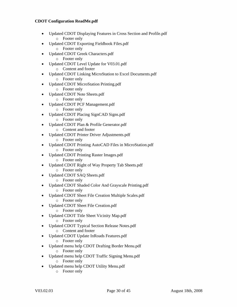
o New workflow for V03.02. • Deleted CDOT Typical Section Release Notes.pdf • Updated Menu Help “CDOT Traffic Signing Menu.pdf”
o Added section on new functionality of “CSUP” and “FHWA” toggles. o Updated screen captures.
• Updated Menu Help “CDOT Utility Menu.pdf” o Updated screen captures.
• Updated CDOT Alignment Display In Cross Section.pdf o Updated footer. o Updated minor text edits.
• Updated CDOT Annotating Horizontal and Vertical Alignments.pdf o Updated footer. o Updated screen captures to correct theme.
• Updated CDOT Batch Printing.pdf o Updated text and screen capture to reflect change in specifications file.
• Updated CDOT Batch Processing.pdf o Updated footer only.
• Updated CDOT Converting AutoCAD Files to MicroStation.pdf o Added section on run this in a batch process mode. o Updated footer. o Updated CDOT Menu screen capture in step 23.
• Updated CDOT Creating Multiple Plan Sheets.pdf o Updated footer. o Updated Cell dialog in step 2. o Updated CDOT Menu command sequence in steps 14-22. o Updated CDOT Menu screen capture in step 23. o Updated other screen captures to reflect linestyle changes.
• Updated CDOT Directory Structure.pdf o Updated footer. o Updated new folders and file naming.
• Updated CDOT Displaying Features in Cross Section and Profile.pdf o Updated footer. o Updated minor text changes.
• Updated CDOT Exporting Fieldbook Files.pdf
V03.02.03 Page 18 of 45 August 18th, 2008
CDOT Configuration ReadMe.pdf
o Added section on Stratify Survey tool. o Updated footer.
• Updated CDOT Greek Characters.pdf o Updated footer only.
• Updated CDOT Level Update for V03.02.pdf o Updated title to reflect version number. o Updated footer o Updated screen captures and text to reflect the addition of levels from all
previous configurations to the csv file. • Updated CDOT Linking MicroStation to Excel Documents.pdf
o Updated Footer • Updated CDOT MicroStation Printing.pdf
o Updated footer. • Updated CDOT Note Sheets.pdf
o Updated footer. o Updated error in step 22 page 10.
• Updated CDOT PCF Management.pdf o Updated footer.
• Updated CDOT Placing SignCAD Signs.pdf o Updated footer.
• Updated CDOT Plan & Profile Generator.pdf • Renamed to CDOT InRoads Plan & Profile Generator.pdf
o Updated footer. o Updated minor text changes.
• Updated CDOT Printer Driver Adjustments.pdf o Updated footer.
• Updated CDOT Printing AutoCAD Files in MicroStation.pdf o Updated footer.
• Updated CDOT Printing Raster Images.pdf o Updated footer.
• Updated CDOT Right of Way Property Tab Sheets.pdf o Updated footer.
• Updated CDOT SAQ Sheets.pdf o Updated footer.
• Updated CDOT Shaded Color And Grayscale Printing.pdf o Updated footer.
• Updated CDOT Sheet File Creation Multiple Scales.pdf o Updated footer.
• Updated CDOT Sheet File Creation.pdf o Updated footer.
• Updated CDOT Title Sheet Vicinity Map.pdf o Updated footer.
• Updated CDOT Update InRoads Features.pdf o Updated footer.
V03.02.03 Page 19 of 45 August 18th, 2008
CDOT Configuration ReadMe.pdf
Custom Programs
• Accident.mvba o Translated Staff Traffic program.
• CDOTMenu.exe o Added functionality to minimize with MicroStation. o Added functionality to open and close with MicroStation. o Added functionality to preview cells. o Added Top 20 list on Traffic Signs menu. Only 13 are defined at this time. o Added the place text along functionality to the Traffic TCD menu. o Added Place Note items to the text button in the Drafting menu. o Added additional items to the database for most disciplines. o Adjust the database to place HYDR cells on the correct levels. o Converted all custom programmed menus to be database driven with the
exception of Traffic Signing. o Deleted database items to reflect changes in the configuration. o Updated database items to reflect changes in the configuration. o Set the default to display all groups. o Modified the existing permanent easement cell to MISC_3_exist o Modified the existing slope easement cell to MISC_3_exist o Modified the existing utility easement cell to MISC_3_exist o Modified the existing city limits cell to PLSS Monument o Modified the existing county line cell to PLSS Monument o Modified the existing miscellaneous cell to PLSS Monument o Modified the existing state line cell to PLSS Monument o Modified the existing township line cell to PLSS Monument o Modified the existing quarter section line cell to ROW_Section-Corner_exist o Modified the existing section line cell to ROW_Section-Corner_exist o Modified the existing sixteenth section line cell to ROW_Section-Corner_exist o Modified the existing lot line cell to Fnd prop mon o Modified the existing property boundary cell to Fnd prop mon o Modified the existing property easement cell to Fnd prop mon o Modified the existing access control cell to Fnd ROW mon o Modified the existing barrier access control cell to Fnd ROW mon o Modified the existing ROW line cell to Fnd ROW mon o Modified the existing ROW line prior cell to Fnd ROW mon o Modified the existing glo lot linecell to Fnd prop mon o Enabled CDOT Bridge menu o Added wording to menu picks for (True Scale) where applicable.
• CDOTRedlines.mvba o Added to attach multiple redline files to a single dgn.
• CDOTSteel.mvba o Included support files; CDOTSteel.ini and CDOTSteel.stbl.
• CellDivide.ma o Modified so that all cells are placed in a graphic group.
• gINT.mvba o Added translator to import boring log data.
• MakeStripmap.mvba o Translated Staff Traffic program.
V03.02.03 Page 20 of 45 August 18th, 2008
CDOT Configuration ReadMe.pdf
o Added functionality to the dialog box to browse for a file, select the highway
which automatically defines the min and max mile posts. • PlaceBreaks.ma
o Added to replace brkline.ma. Gives additional functionality of drawing with a breakline, and placing cylinder/pipe breaks.
o Added Placebreaks.mvba for an interface in MicroStation. Both the ma and MVBA are required, as the MVBA provides the interface to the ma.
• Roughen.ma o Updated to work with other types of elements. o Added Roughen.mvba for an interface in MicroStation. Both the ma and MVBA
are required, as the MVBA provides the interface to the ma. • StratifySurvey.mvba
o Added to separate fieldbook features into separate dgn files and automatically attach them to the master dgn file.
• TextAlong.mvba o Added to edit text in survey cap cells and retain the circular orientation. o
• TypicalSection.exe o Modified level assignments. o Added text styles to the text. o Added dimension styles to dimensioning.
• XYDistance.mvba o Added to measuring tool to work in both MicroStation and Redline.
InRoads Preferences
• CDOT-Preferences.ini o InRoads Tools>Options [Tolerances], set default chord height to 0.10 o Added a preference for superelevation diagram display using profile annotation
command o Removed profile annotation preference ‘CDOT 100 Scale’ as it is no longer
necessary. o Changed feature filter names and filters to sort by primary pay item number were
appropriate o Added features H_DETENTION_Pond-Top & H_ DETENTION _Pond-Bottom o Added named symbology H_ DETENTION-Pond o Added both feature styles and named symbologies for Hydrology discipline. o Modified the Plan and Profile generator preferences to call the seed file: 3D-
Seed.dgn o Modified horizontal and vertical curve data to have a space before and after the
“=” sign. • XML style Sheets
o Modified the XML style sheet CDOT A-line Description.xsl o Removed the XML style sheet CDOT_PropertyDescription.xsl
V03.02.03 Page 21 of 45 August 18th, 2008
CDOT Configuration ReadMe.pdf
Storm and Sanitary
• CDOT-HYDR-Structures.dat o Added file.
• Renamed Hydraulic (H_*) feature styles and named symbologies to the new naming convention.
• Adjusted preferences to the new feature style and named symbologies. • Configured Drainage Options for primary inlets and default structure settings • Created appropriate initial Preferences for hydraulics commands.
Survey Preferences
• CDOT-Survey_Features.fwf o Added code 5169 Variable Message Sign (IL 5169) o Sorted Survey Codes numerically.
• CDOT-Survey_Features.fxp o Minor changes to default text height made to survey notes (text size 0.071 vs.
0.070) for development of stratify survey tool. MicroStation Configuration
• Added CDOT_IPlot.ucf to be placed in “C:\Program Files\Bentley\Workspace\Users” • Added ip.cfg to be placed in “C:\Program Files\MicroStation PDF Composer\config” • Added iplot.cfg to be placed in “C:\Program Files\Common Files\InterPlot\IPLOT
\config” • Added dimension style CDOT 4.
o Coordinate readout of 0.12 o Bspline leaders.
• Added dimension style CDOT 5 o Coordinate readout of 0. o To be used for elevations.
• Added Architectural scales to the model properties. • Added and modified functionality to attach geo-referenced imagery. • Added fractions and special characters in the AsConst font. • Added changed to the remapping CSV file. • Added variable to start CDOT Menu on MicroStation start-up. • Added the Change Element Direction icon to the Misc. Tools palette. • Modified all dimension styles to use the default filled arrowhead with a 3:1 ratio. • Modified the Font.rsc to resize the special characters. • Modified the Linestyle.rsc file.
o Change the style for HYDR_PIPES_* • Modified user preferences to change settings for Raster Manager. • Modified the Traffic Tab spreadsheet to turn off the gridlines. • Modified the default user preferences to compress on exit. • Modified all seed files with an ACS to 0,0,0. • Rebuilt User and Site interface files. • Renamed the remapping CSV file to “V0302_Level_Update.csv” since this file can be
used at any of the previous configurations to bring it up to the latest version.
V03.02.03 Page 22 of 45 August 18th, 2008

CDOT Configuration ReadMe.pdf
• Turned on View 7 as a Front view in all models as a default. • Modified all models in the configuration to turn on the keep region boundary toggle.
Cell Libraries
• Change the graphics to level Default in most models. • Bridge.cel
o Modified section bubble models to be hard coded to levels “BRDG_TITLE” and “BRDG_TOOLS_Text”
o Moved “drainage_type-r_inlet-top”, “drainage_type-r_inlet-side”, “drainage_precast-box”, “drainage_mhstep-top”, “drainage_mhstep-side”, “drainage_mhstep-front”, “drainage_mh-rung”, “drainage_manhole”, “drainage_m-605-25-grate-top”, “drainage_m-604-box-top”, “drainage_m-604-25-grate-side”, “drainage_m-604-25-grate-front”, “drainage_m-604-25-box-side”, “drainage_m-604-25-box-front”, “drainage_spt90”, “drainage_cpt45”, “drainage_ASdrain-top”, “drainage_18cmp” to hydraulics cell library.
o Changed levels to cells moved over from bridge to drafting levels where appropriate.
o Moved Bridge RE’s to bridge cell lib. o Deleted cells above from database so that they are no longer called under Bridge
on the CDOT Menu • General.cel
o Added model “SYMBOL_Hexagon” o Added model “SHEET_Design-A-Size-Sheet-Landscape” o Added model “SHEET_FOR-Stamp” o Added model “SHEET_FIR-Stamp” o Added model “SHEET_Call811-Stamp” o Added model “SHEET_CDOT-Logo” o Added model “SYMBOL_Open-Star” o Added model “SYMBOL_Open-Diamond” o Added model “SYMBOL_Open-Hexagon” o Added model “SYMBOL_Double-Plus” o Added model “SYMBOL_Approximately-Equal” o Added username, time and full file path to all sheet files. o Added RE cell for Russel Cox. o Added RE cell for Leele Rajasekar. o Added RE cell for Steve Hersey. o Added RE cell for Saeed Sobhi o Added RE cell for Ajin Hu o Added RE cell for David Martinez o Added RE cell for Corey Stewart o Added RE cell for Jim Horn o Added RE cell for Don Sjaastad o Added RE cell for Rick Erjavec o Added RE cell for Gary Gonzales o Added RE cell for Anthony Stewart o Deleted RE cell for Anthony Devito. o Deleted RE cell for Jeff Wassenaar. o Deleted RE cell for Scott MsDaniel. o Deleted RE cell for Ken DePinto.
V03.02.03 Page 23 of 45 August 18th, 2008
CDOT Configuration ReadMe.pdf
o Deleted RE cell for Johnny Olson. o Deleted RE cell for Dave Eller. o Deleted RE cell Richard Zamora. o Change address RE cell James Flohr. o Deleted Roadway Title block cell o Deleted RE cell Jim Zufall o Changed name on RE cell to Ina Zisman. o Changed name on RE cell to Brett Locke o Changed phone and fax number for Craig Snyder (phone (970) 683-6351 fax
(970) 683-6369 o Moved Bridge RE’s to Bridge.cel o Deleted model “SHEET_UNCC-Stamp” o Modified RE cell for Mark Mueller. o Modified all SYMBOL_* models to be .07” in height. o Modified the PCD and LSCD Title sheets to remove the general notes. o Modified the location and justification of all sheet border titles. (also done for
autopopulate sheets) • Hydraulics.cel
o Added model “HYDR_Manhole-Proposed’ o Added model “HYDR_Rural_Callout” o Added model “HYDR_Urban_Flow_Callout” o Moved “drainage_type-r_inlet-top”, “drainage_type-r_inlet-side”,
“drainage_precast-box”, “drainage_mhstep-top”, “drainage_mhstep-side”, “drainage_mhstep-front”, “drainage_mh-rung”, “drainage_manhole”, “drainage_m-605-25-grate-top”, “drainage_m-604-box-top”, “drainage_m-604-25-grate-side”, “drainage_m-604-25-grate-front”, “drainage_m-604-25-box-side”, “drainage_m-604-25-box-front”, “drainage_spt90”, “drainage_cpt45”, “drainage_ASdrain-top”, “drainage_18cmp” from bridge cell library.
o Added above cells to the database to be called from Hydraulics on the CDOT Menu under Drainage
• Materials_&_Geotechnical.cel o Added model “auger-boring” o Added model “fill” o Added model “legend” o Added model “legend-bottom” o Added model “material-type” o Added model “penetration-test” o Added model “rotary-boring” o Added model “test-boring” o Added model “wireline-boring”
• Pattern.cel o Updated model “PATTERN_Concrete” o Updated model “PATTERN_Gravel” o Updated model “PATTERN_Masonry” o Updated model “PATTERN_Rock” o Updated model “PATTERN_Timber-1” o Updated model “PATTERN_Timber-2” o Updated model “PATTERN_Timber-3” o Updated model “PATTERN_Timber-4”
• Roadway_Design.cel
V03.02.03 Page 24 of 45 August 18th, 2008
CDOT Configuration ReadMe.pdf
o Added design driven cell for ramps “DES_Ped_Ramp_On_Radus_Type2”. o Added design driven cell for ramps “DES_Ped_Ramp_On_Tangent”. o Modified the XSEC annotation cell to use approved POSS abbreviation.
• ROW.cel o Added Survey Supervisor cell for Dave Stewart. o Deleted the Total Number of Sheets on all ROW plan Sheets. The Title Sheets
are the only sheets that display this information. o Delete Survey Supervision cell for Joe Conway o Modified numerous models to graphic cells.
• Topo.cel o Changed numerous models to graphic cells.
• TRAF_General.cel o Added model “Ped-Head’
• TRAF_Signs.cel o Reviewed all signs and changed, deleted and added signs based on the MUTCD
standards. o Converted many AutoCAD signs. o Renamed signs to include keywords “CSUP” for Colorado Supplemental signs
and “FHWA” for Federal highways Association signs. • TRAF_TCD.cel
o Removed model “Note-Hex’ o Removed model “Note-Tri”
Level Libraries
• Bridge.dgnlib o Added level “BRDG_TOOLS_Center-Abutment” color 50, linetype 4, weight 0 o Added level “BRDG_TOOLS_Center-Bolts” color 60, linetype 4, weight 0 o Added level “BRDG_TOOLS_Center-Diaphragm” color 106, linetype 4, weight
0 o Added level “BRDG_TOOLS_Center-Pier” color 141, linetype 4, weight 0 o Added level “BRDG_TOOLS_Outline-Anchor” color 152, linetype 0, weight 2 o Added level “BRDG_TOOLS_Outline-Bearings” color 104, linetype 0, weight 2 o Added level “BRDG_TOOLS_Outline-Bolts” color 70, linetype 0, weight 2 o Added level “BRDG_TOOLS_Outline-Concrete” color 30, linetype 0, weight 2 o Added level “BRDG_TOOLS_Outline-Connection” color 102, linetype 0, weight
2 o Added level “BRDG_TOOLS_Outline-ConstructionJoint” color 45, linetype 0,
weight 2 o Added level “BRDG_TOOLS_Outline-Damage” color 90, linetype 0, weight 2 o Added level “BRDG_TOOLS_Outline-Diaphragm” color 138, linetype 0, weight
2 o Added level “BRDG_TOOLS_Outline-Embed” color 85, linetype 0, weight 2 o Added level “BRDG_TOOLS_Outline-ExpansionJoint” color 83, linetype 0,
weight 2 o Added level “BRDG_TOOLS_Outline-Falsework” color 91, linetype 0, weight 2 o Added level “BRDG_TOOLS_Outline-Foundation-Footer” color 83, linetype 0,
weight 2 o Added level “BRDG_TOOLS_Outline-FRP” color 82, linetype 0, weight 2 o Added level “BRDG_TOOLS_Outline-Future” color 44, linetype 6, weight 1
V03.02.03 Page 25 of 45 August 18th, 2008
CDOT Configuration ReadMe.pdf
o Added level “BRDG_TOOLS_Outline-Girder” color 42, linetype 0, weight 2 o Added level “BRDG_TOOLS_Outline-Repair” color 75, linetype 0, weight 2 o Added level “BRDG_TOOLS_Outline-Rustications” color 75, linetype 0, weight
1 o Added level “BRDG_TOOLS_Outline-SignStructure” color 108, linetype 0,
weight 2 o Added level “BRDG_TOOLS_Outline-Weld” color 92, linetype 0, weight 1 o Renamed level “BRDG_CONTOURS_Major” to
“BRDG_TOOLS_CONTOURS_Major” o Renamed level “BRDG_CONTOURS_Major-Text” to
“BRDG_TOOLS_CONTOURS_Major-Text” o Renamed level “BRDG_CONTOURS_Minor” to
“BRDG_TOOLS_CONTOURS_Minor” o Renamed level “BRDG_REBAR-1” to “BRDG_TOOLS_REBAR-1” o Renamed level “BRDG_REBAR-2” to “BRDG_TOOLS_REBAR-2” o Renamed level “BRDG_REBAR-3” to “BRDG_TOOLS_REBAR-3” o Renamed level “BRDG_REBAR-4” to “BRDG_TOOLS_REBAR-4” o Renamed level “BRDG_TOOLS_Equipment” to “BRDG_TOOLS_Outline-
Equipment” color 100, linetype 0, weight 2 o Renamed level level “BRDG_TOOLS_Drainage” to “BRDG_TOOLS_Outline-
Drainage” changed lineweight to 2 o Added filter “Bridge+Tools” o Added filter “Bridge+Draft” o Added filter “Bridge+Draft+Sheet o Modified filter “Bridge”
• GIS.dgnlib o Modified level “GIS_Major-Roads” to a weight of 2.
• Hydraulics.dgnlib o Added level “HYDR_Detension-Pond” o Added level “HYDR_PIPES_Temp” o Added level “HYDR_Temp” o Added level “HYDR_BASIN_Map-Text” o Deleted level “HYDR_Text”
• Remapped to “DRAFT_Text-2” o Deleted level “HYDR_General-Note”
• Remapped to “DRAFT_Text-3” o Deleted level “HYDR_Frozen”
• Remapped to “DRAFT_INFO_Hidden” o Deleted level “HYDR_Draft”
• .. Remapped to “DRAFT_WT-1” o Modified all HYDR_PIPES_* levels to a weight of 5 except the existing level.
• Materials_and_Geotechnical.dgnlib o Modified the filter name to match the dgnlib name.
• Roadway_Design.dgnlib o Added level “DES_Misc” o Added level “DES_Annotation” o Added level “DES_Subgrade-Top” o Added level “DES_Existing-Ground” o Added level “DES_Finished-Grade” o Added level “DES_Volume-Text”
V03.02.03 Page 26 of 45 August 18th, 2008
CDOT Configuration ReadMe.pdf
o Deleted level “DES_PROFILE_Other”
• Remaped to “DES_Misc” o Deleted level “DES_PROFILE_Annotation”
• Remapped to “DES_Annotation” o Deleted level “DES_PROFILE_Base-Top”
• Remapped to “DES_SURFACE_2” o Deleted level “DES_PROFILE_Existing-Ground”
• Remapped to “DES_Existing-Ground” o Deleted level “DES_PROFILE_Finished-Grade”
• Remapped to “DES_Finished-Grade” o Deleted level “DES_PROFILE_Subgrade”
• Remapped to “DES_Subgrade-Top” o Deleted level “DES_XSEC_Asphalt-Bottom”
• Remapped to “DES_SURFACE_1” o Deleted level “DES_XSEC_Asphalt-Top”
• Remapped to “DES_SURFACE_1” o Deleted level “DES_XSEC_Annotation”
• Remapped to “DES_Annotation” o Deleted level “DES_XSEC_Base-Course-Top”
• Remapped to “DES_SURFACE_2” o Deleted level “DES_XSEC_Existing-Ground’
• Remapped to “DES_Existing-Ground” o Deleted level “DES_XSEC_Finished-Grade”
• Remapped to “DES_Finished-Grade” o Deleted level “DES_XSEC_Misc”
• Remapped to “DES_Misc” o Deleted level “DES_XSEC_Other”
• Remapped to “DES_Misc” o Deleted level “DES_XSEC_Subbase-Top”
• Remapped to “DES_SURFACE_3” o Deleted level “DES_XSEC_Subgrade-Top”
• Remapped to “DES_Subgrade-Top” o Deleted level “DES_XSEC_Volume”
• Remapped to “DES_Misc” o Deleted level “DES_XSEC_Volume-Text”
• Remapped to “DES_Volume-Text” o Modified level “DES_ROADWAY_Ditch-Flowline”
• Changed style to 4. • Topo.dgnlib
o Change the color of level “TOPO_TERRAIN_Contours-Minor” to 84. o Added a filter “TOPO_Roadway”.
Seed Files
• Removed all Group specific seed files. • Added 2D-Seed_CDOT.dgn • Added 3D-Seed_CDOT.dgn • Added 4-Sig-Fig-Seed_CDOT.dgn
V03.02.03 Page 27 of 45 August 18th, 2008
CDOT Configuration ReadMe.pdf
Plotting
• Added a new text substitution for plot information; username, time and full file path. • PDF Composer
o Added DesignScripts files. • CDOT.dscript
• CDOT-ACAD.dscript • CDOT-Color.dscript • CDOT-ColorwithYellowtoBlack.dscript • CDOT-Shading_Grayscale.dscript
o Added IPlotSettings files • CDOT 8.5x11 Color.set • CDOT 8.5x11 Shaded.set • CDOT 8.5x11.set • CDOT 11x17 Color.set • CDOT 11x17 Shaded.set • CDOT 11x17.set • CDOT 22x34 Color.set • CDOT 22x34 Shaded.set • CDOT 22x34.set • CDOT.set
• Updated Pen table to fix text printing behind grid lines. The variable is set. • Updated CDOT-Shading_GrayscalePenTable.tbl to display pen weights. • Updated CDOT-ColorPenTable.tbl to plot Username and directory path. • Known Issues • The menus in V03.02 are started with CDOTMDL.ma, which runs in the background.
The added functionality will not be present in Redline since it is a limitation of the software. The menus will work with Redline just not as seamlessly as in MicroStation.
• The User and Site interface files were rebuilt for this release. You will lose any customizations that have made to the MicroStation interface. All InRoads customizations will not be lost.
• Redline will not work properly if you have a project folder structure that is missing the Redline folder, \JPC#\Redline. You can manually add the folder (and update the existing PCF File with the added folder), to the structure or rerun the Create Project Utility and move files to the appropriate location.
• The call 811 Image and or the CDOT Image, increases the plot spooling time when printing to a standard printer. Plotting to a PDF file is not affected.
• The Staff Traffic program Stripmap displays graphic past specified mile posts. Some graphics are cut off at the last whole mile post. This is an issue with how the database was created.
• Added Bentley printing files to facilitate encountered printing problems. Copy these files below into the C:\Program Files\Bentley\Program\MicroStation\mdlsys\asneeded
o pentable.ma o pntbldlm.dll
• Added Aerial monospaced for SAP font into the Excel and Word documents contained the CDOT-Workspace. Copy these files below into the C:\WINDOWS\Fonts
o arimon__.ttf o arimonbd.ttf
V03.02.03 Page 28 of 45 August 18th, 2008
CDOT Configuration ReadMe.pdf
Introduction
This Read Me has been divided into the following sections. New Features – Default Project Directory Documentation Custom Programs InRoads Preferences
MicroStation Configuration Cell Libraries Level Libraries Plotting Redline Configuration Known Issues New Features Version 03.01 March 5th, 2007 This release implements the following enhancements and fixed problems that have been reported during production. Updates made to Documentation for additional workflows, Custom Programs for Menu update/fix, MicroStation Configuration, and plotting. Default Project Directory
• Added the folder Research under, \Workspace-CDOT\Project Template\ROW_Survey\ • Added the folder Government under, \Workspace-CDOT\Project
Template\ROW_Survey\Research\ • Added the folder Miscellaneous under, \Workspace-CDOT\Project
Template\ROW_Survey\Research\ • Added the folder Plans under, \Workspace-CDOT\Project
Template\ROW_Survey\Research\ • Added the folder Title under, \Workspace-CDOT\Project
Template\ROW_Survey\Research\
Documentation • Updated CDOT Alignment Display In Cross Section.pdf
o Footer only • Updated CDOT Annotating Horizontal and Vertical Alignments.pdf
o Footer only • Updated CDOT Batch Printing.pdf
o Footer only • Updated CDOT Batch Processing.pdf
o Footer only • Updated CDOT Converting AutoCAD Files to MicroStation.pdf
o Footer only • Updated CDOT Creating Multiple Plan Sheets.pdf
o Footer only • Updated CDOT Directory Structure.pdf
o Content and footer
V03.02.03 Page 29 of 45 August 18th, 2008
CDOT Configuration ReadMe.pdf
• Updated CDOT Displaying Features in Cross Section and Profile.pdf
o Footer only • Updated CDOT Exporting Fieldbook Files.pdf
o Footer only • Updated CDOT Greek Characters.pdf
o Footer only • Updated CDOT Level Update for V03.01.pdf
o Content and footer • Updated CDOT Linking MicroStation to Excel Documents.pdf
o Footer only • Updated CDOT MicroStation Printing.pdf
o Footer only • Updated CDOT Note Sheets.pdf
o Footer only • Updated CDOT PCF Management.pdf
o Footer only • Updated CDOT Placing SignCAD Signs.pdf
o Footer only • Updated CDOT Plan & Profile Generator.pdf
o Content and footer • Updated CDOT Printer Driver Adjustments.pdf
o Footer only • Updated CDOT Printing AutoCAD Files in MicroStation.pdf
o Footer only • Updated CDOT Printing Raster Images.pdf
o Footer only • Updated CDOT Right of Way Property Tab Sheets.pdf
o Footer only • Updated CDOT SAQ Sheets.pdf
o Footer only • Updated CDOT Shaded Color And Grayscale Printing.pdf
o Footer only • Updated CDOT Sheet File Creation Multiple Scales.pdf
o Footer only • Updated CDOT Sheet File Creation.pdf
o Footer only • Updated CDOT Title Sheet Vicinity Map.pdf
o Footer only • Updated CDOT Typical Section Release Notes.pdf
o Content and footer • Updated CDOT Update InRoads Features.pdf
o Footer only • Updated menu help CDOT Drafting Border Menu.pdf
o Footer only • Updated menu help CDOT Traffic Signing Menu.pdf
o Footer only • Updated menu help CDOT Utility Menu.pdf
o Footer only
V03.02.03 Page 30 of 45 August 18th, 2008
CDOT Configuration ReadMe.pdf
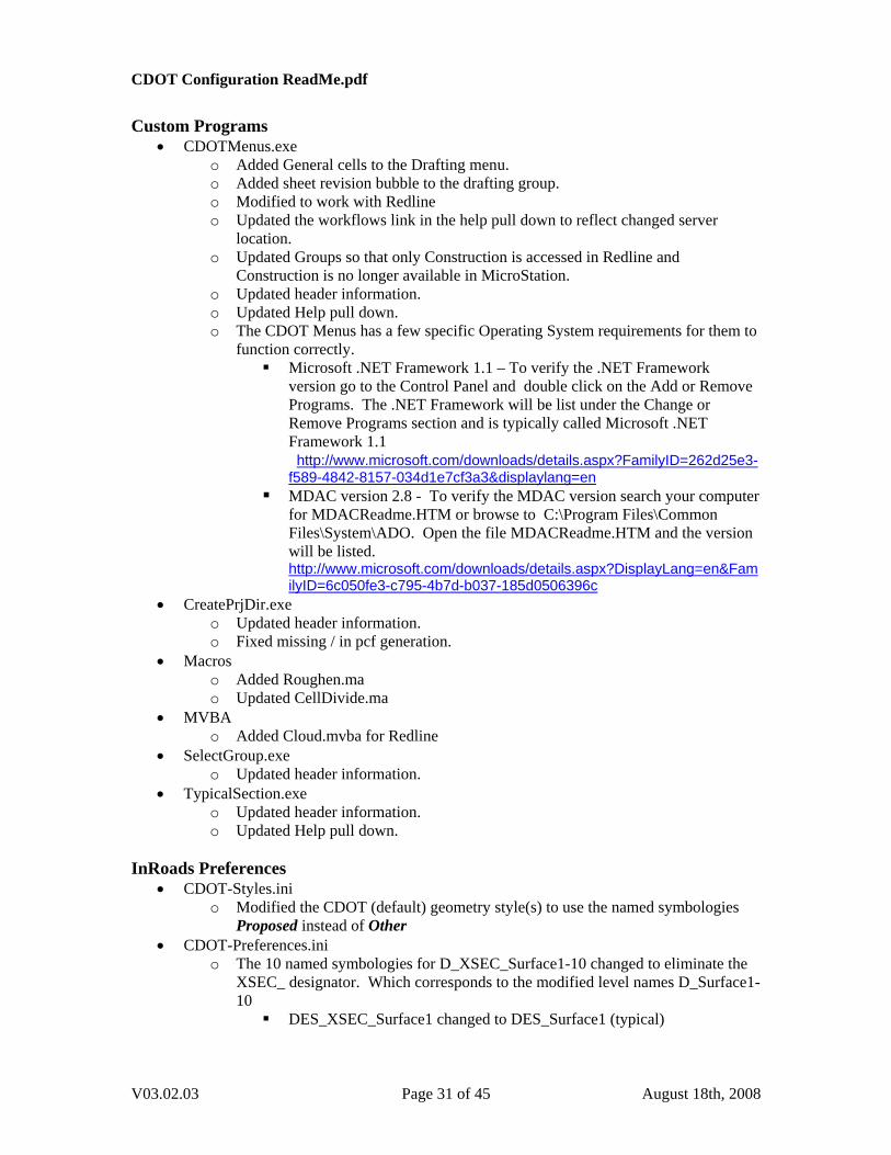
Custom Programs
• CDOTMenus.exe o Added General cells to the Drafting menu. o Added sheet revision bubble to the drafting group. o Modified to work with Redline o Updated the workflows link in the help pull down to reflect changed server
location. o Updated Groups so that only Construction is accessed in Redline and
Construction is no longer available in MicroStation. o Updated header information. o Updated Help pull down. o The CDOT Menus has a few specific Operating System requirements for them to
function correctly. Microsoft .NET Framework 1.1 – To verify the .NET Framework
version go to the Control Panel and double click on the Add or Remove Programs. The .NET Framework will be list under the Change or Remove Programs section and is typically called Microsoft .NET Framework 1.1 http://www.microsoft.com/downloads/details.aspx?FamilyID=262d25e3-f589-4842-8157-034d1e7cf3a3&displaylang=en
MDAC version 2.8 - To verify the MDAC version search your computer for MDACReadme.HTM or browse to C:\Program Files\Common Files\System\ADO. Open the file MDACReadme.HTM and the version will be listed. http://www.microsoft.com/downloads/details.aspx?DisplayLang=en&FamilyID=6c050fe3-c795-4b7d-b037-185d0506396c
• CreatePrjDir.exe o Updated header information. o Fixed missing / in pcf generation.
• Macros o Added Roughen.ma o Updated CellDivide.ma
• MVBA o Added Cloud.mvba for Redline
• SelectGroup.exe o Updated header information.
• TypicalSection.exe o Updated header information. o Updated Help pull down.
InRoads Preferences
• CDOT-Styles.ini o Modified the CDOT (default) geometry style(s) to use the named symbologies
Proposed instead of Other • CDOT-Preferences.ini
o The 10 named symbologies for D_XSEC_Surface1-10 changed to eliminate the XSEC_ designator. Which corresponds to the modified level names D_Surface1-10
DES_XSEC_Surface1 changed to DES_Surface1 (typical)
V03.02.03 Page 31 of 45 August 18th, 2008
CDOT Configuration ReadMe.pdf
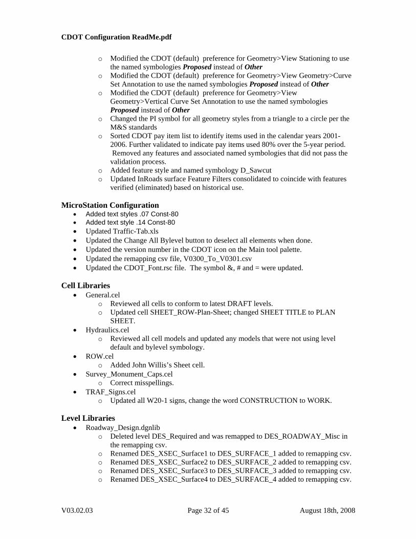
o Modified the CDOT (default) preference for Geometry>View Stationing to use
the named symbologies Proposed instead of Other o Modified the CDOT (default) preference for Geometry>View Geometry>Curve
Set Annotation to use the named symbologies Proposed instead of Other o Modified the CDOT (default) preference for Geometry>View
Geometry>Vertical Curve Set Annotation to use the named symbologies Proposed instead of Other
o Changed the PI symbol for all geometry styles from a triangle to a circle per the M&S standards
o Sorted CDOT pay item list to identify items used in the calendar years 2001-2006. Further validated to indicate pay items used 80% over the 5-year period. Removed any features and associated named symbologies that did not pass the validation process.
o Added feature style and named symbology D_Sawcut o Updated InRoads surface Feature Filters consolidated to coincide with features
verified (eliminated) based on historical use. MicroStation Configuration
• Added text styles .07 Const-80 • Added text style .14 Const-80 • Updated Traffic-Tab.xls • Updated the Change All Bylevel button to deselect all elements when done. • Updated the version number in the CDOT icon on the Main tool palette. • Updated the remapping csv file, V0300_To_V0301.csv • Updated the CDOT_Font.rsc file. The symbol &, # and = were updated.
Cell Libraries
• General.cel o Reviewed all cells to conform to latest DRAFT levels. o Updated cell SHEET_ROW-Plan-Sheet; changed SHEET TITLE to PLAN
SHEET. • Hydraulics.cel
o Reviewed all cell models and updated any models that were not using level default and bylevel symbology.
• ROW.cel o Added John Willis’s Sheet cell.
• Survey_Monument_Caps.cel o Correct misspellings.
• TRAF_Signs.cel o Updated all W20-1 signs, change the word CONSTRUCTION to WORK.
Level Libraries
• Roadway_Design.dgnlib o Deleted level DES_Required and was remapped to DES_ROADWAY_Misc in
the remapping csv. o Renamed DES_XSEC_Surface1 to DES_SURFACE_1 added to remapping csv. o Renamed DES_XSEC_Surface2 to DES_SURFACE_2 added to remapping csv. o Renamed DES_XSEC_Surface3 to DES_SURFACE_3 added to remapping csv. o Renamed DES_XSEC_Surface4 to DES_SURFACE_4 added to remapping csv.
V03.02.03 Page 32 of 45 August 18th, 2008
CDOT Configuration ReadMe.pdf
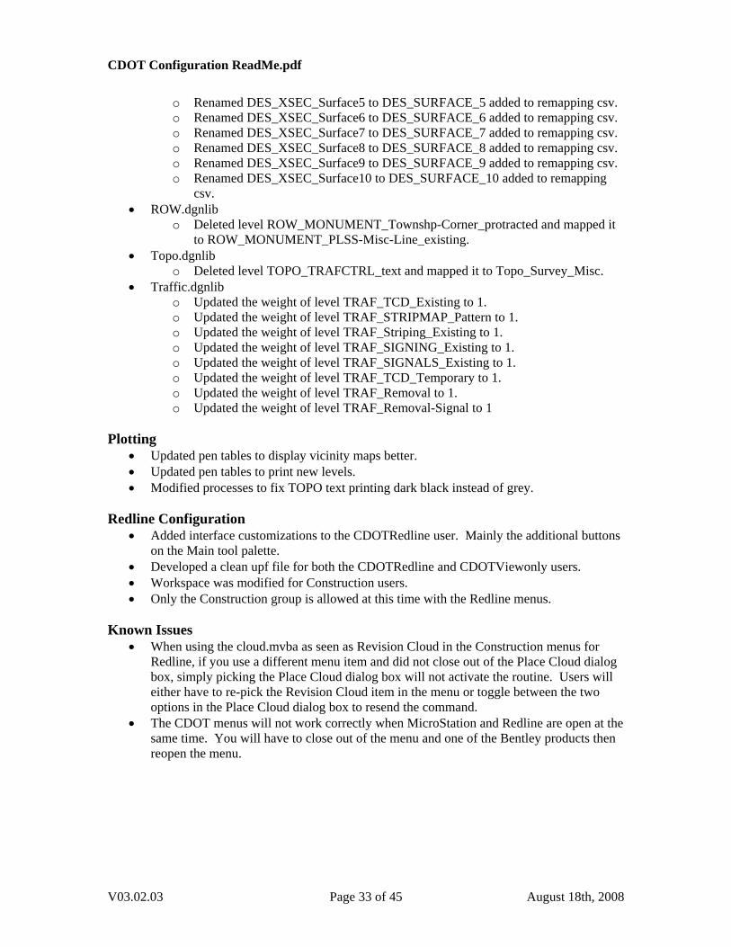
o Renamed DES_XSEC_Surface5 to DES_SURFACE_5 added to remapping csv. o Renamed DES_XSEC_Surface6 to DES_SURFACE_6 added to remapping csv. o Renamed DES_XSEC_Surface7 to DES_SURFACE_7 added to remapping csv. o Renamed DES_XSEC_Surface8 to DES_SURFACE_8 added to remapping csv. o Renamed DES_XSEC_Surface9 to DES_SURFACE_9 added to remapping csv. o Renamed DES_XSEC_Surface10 to DES_SURFACE_10 added to remapping
csv. • ROW.dgnlib
o Deleted level ROW_MONUMENT_Townshp-Corner_protracted and mapped it to ROW_MONUMENT_PLSS-Misc-Line_existing.
• Topo.dgnlib o Deleted level TOPO_TRAFCTRL_text and mapped it to Topo_Survey_Misc.
• Traffic.dgnlib o Updated the weight of level TRAF_TCD_Existing to 1. o Updated the weight of level TRAF_STRIPMAP_Pattern to 1. o Updated the weight of level TRAF_Striping_Existing to 1. o Updated the weight of level TRAF_SIGNING_Existing to 1. o Updated the weight of level TRAF_SIGNALS_Existing to 1. o Updated the weight of level TRAF_TCD_Temporary to 1. o Updated the weight of level TRAF_Removal to 1. o Updated the weight of level TRAF_Removal-Signal to 1
Plotting
• Updated pen tables to display vicinity maps better. • Updated pen tables to print new levels. • Modified processes to fix TOPO text printing dark black instead of grey.
Redline Configuration
• Added interface customizations to the CDOTRedline user. Mainly the additional buttons on the Main tool palette.
• Developed a clean upf file for both the CDOTRedline and CDOTViewonly users. • Workspace was modified for Construction users. • Only the Construction group is allowed at this time with the Redline menus.
Known Issues
• When using the cloud.mvba as seen as Revision Cloud in the Construction menus for Redline, if you use a different menu item and did not close out of the Place Cloud dialog box, simply picking the Place Cloud dialog box will not activate the routine. Users will either have to re-pick the Revision Cloud item in the menu or toggle between the two options in the Place Cloud dialog box to resend the command.
• The CDOT menus will not work correctly when MicroStation and Redline are open at the same time. You will have to close out of the menu and one of the Bentley products then reopen the menu.
V03.02.03 Page 33 of 45 August 18th, 2008
CDOT Configuration ReadMe.pdf
Introduction
This Read Me has been divided into the following sections. New Features – Default Project Directory Documentation Custom Programs InRoads Preferences Survey Preferences
MicroStation Configuration Cell Libraries Level Libraries Plotting Known Issues New Features Version 03.00 December 11th, 2006 This release implements the following enhancements and fixed problems that have been reported during production. Updates made to Documentation for additional workflows, Custom Programs for Menu update/fix, MicroStation Configuration, and plotting. Default Project Directory
• JPC#GeneralNotesSheet01.dgn was added to \Workspace-CDOT\Project Template\Design\Drawings.
• JPC#GeneralNotesSheet02.dgn was added to \Workspace-CDOT\Project Template\Design\Drawings.
• JPC#DesignGeneralNote.dgn was added to \Workspace-CDOT\Project Template\Design\Drawings\Reference_Files.
• JPC#DesignGeneralNote.txt was added to \Workspace-CDOT\Project Template\Design\Drawings\Reference_Files.
• Removed Index of Sheets. • Delete the duplicate file JPC#SURVTabSheet##.dgn. • Change active level to DRAFT_WT-3 in sheets, JPC#StandardPlanList.dgn and
JPC#SURVTabSheet.dgn. • JPC#ROWTabulationPropertiesSheet##.dgn has been updated to use an Excel
spreadsheet. (See the workflow, “CDOT Right of Way Property Tab Sheets.doc”) • Moved JPC#ApproximateQuantities##.dgn from Sheet_Borders to project template • Moved JPC#EarthworkQuantities##.dgn from Sheet_Borders to project template • Moved JPC#SURVTabSheet.dgn from Sheet_Borders to project template • Moved JPC#TypicalSection##.dgn from Sheet_Borders to project template • Moved JPC#ROWMonumentationSheet##.dgn from Sheet_Borders to project template • Moved JPC#ROWOwnershipSheet##.dgn from Sheet_Borders to project template • Moved JPC#ROWSheet##.dgn from Sheet_Borders to project template • Moved JPC#ROWTitleSheet.dgn from Sheet_Borders to project template • Moved JPC#SURVPlanSheetLSCD##.dgn from Sheet_Borders to project template • Moved JPC#SURVPlanSheetPCD##.dgn from Sheet_Borders to project template
V03.02.03 Page 34 of 45 August 18th, 2008
CDOT Configuration ReadMe.pdf
• Moved JPC#SURVTitleSheetLSCD.dgn from Sheet_Borders to project template • Moved JPC#SURVTitleSheetPCD.dgn from Sheet_Borders to project template
Documentation • Updated CDOT Batch Printing.pdf • Updated CDOT Batch Processing.pdf • Updated CDOT Creating Multiple Plan Sheets.pdf • Updated CDOT Directory Structure.pdf • Updated CDOT Greek Characters.pdf • Updated CDOT Linking MicroStation to Excel Documents.pdf • Updated CDOT MicroStation Printing.pdf • Updated CDOT PCF Management.pdf • Updated CDOT Placing SignCAD Signs.pdf • Updated CDOT Plan & Profile Generator.pdf • Updated CDOT Printer Driver Adjustments.pdf • Updated CDOT Sheet File Creation Multiple Scales.pdf • Updated CDOT Sheet File Creation.pdf • Updated CDOT Title Sheet Vicinity Map.pdf • Updated CDOT Typical Section Release Notes.pdf • Updated CDOT Update InRoads Features.pdf • Added CDOT Alignment Display In Cross Section.pdf • Added CDOT Annotating Horizontal and Vertical Alignments.pdf • Added CDOT Converting AutoCAD Files to MicroStation.pdf • Added CDOT Displaying Features in Cross Section and Profile.pdf • Added CDOT Exporting Fieldbook Files.pdf • Added CDOT Level Update for V03.00.pdf • Added CDOT Note Sheets.pdf • Added CDOT Printing AutoCAD Files in MicroStation.pdf • Added CDOT Printing Raster Images.pdf • Added CDOT Right of Way Property Tab Sheets.pdf • Added CDOT SAQ Sheets.pdf • Added CDOT Shaded Color And Grayscale Printing.pdf • Added menu help CDOT Drafting Border Menu.pdf • Added menu help CDOT Traffic Signing Menu.pdf • Added menu help CDOT Utility Menu.pdf
Custom Programs
• CDOTMenus.exe o Construction was migrated from the mdf menus. o All Discipline GUI’s have been updated. o Menus remember last command for each selection. o Added Menu help documents for Drafting>borders, Traffic ITS>Signing and
Utilities. o Added unload items for all macros under the Add-On’s pull down. o Added a Launch Bridge Menus item under the Add-On’s pull down. This is to
be used to reload the bridge menus if they are closed in MicroStation. • TypicalSection.exe
o Updated required fields. o Updated leader lines.
V03.02.03 Page 35 of 45 August 18th, 2008
CDOT Configuration ReadMe.pdf
o Updated to use level name changes. o Corrected the widening display.
• Macros o Added txt2node.ma
• The CDOT – Menu, CDOT – Create Typical Sections, CDOT – Create Project Directory, and Select Group Environment programs have the current version in the program window’s title bar.
InRoads Preferences
• CDOT-Styles.ini o Using the right click view command the Spiral TS, CS, SC, and ST were being
displayed as a triangle point (by text). Switched it to a circle symbol (by text) per M standards.
o A space following the Geometry Point prefixes exists for TS, CS, SC, ST, etc. Per M Standards “TS Sta=1+30.83” (CDOT preference still needs to force-loaded as this is a known bug in InRoads)
o Geometry styles for Section lines modified to direct graphics to levels renamed from ‘proposed’ to ‘ protracted’
o Named Symbologies for ROW geometry styles renamed to match geometry style names.
o Removed all geometry styles that referred to: Alg_Alternate Alg_Appr (approach) Alg_Obsolete Alg_Ramp
o Re-associated vertical geometry styles for segregation of tangent lines: ALG_OTHER_Hor-Tangent-Lines ALG_PROPOSED_Hor-Tangent-Lines ALG_SECONDARY_Hor-Tangent-Lines ALG_EXISTING_Hor-Tangent-Lines
o Alignment annotation reformatted to conform to the 2006 M standards. A workflow document has been developed to assist the users with annotating curves with and without spiral transitions.
o Geometry Styles ALG….Horizontal-Keypoints-text have been removed. A single geometry style ALG_COGO_Points has been created in their place has been created for use with all ALG_ prefixed geometry styles.
• CDOT-Preferences.ini o Feature style & named symbology D_SI-Cut renamed to D_Top-of-Cut o Feature style & named symbology D_SI_Fill renamed to D_Toe-of-Fill o Existing Ground symbology ‘Existing Ground’ renamed to ‘T_Existing_Ground o The Named Symbology D_BRIDGERAIL has been renamed to
B_BRIDGERAIL o All Feature Styles D_BRAIL-Ty-* have been renamed to B_ RAIL-Ty-* o Redirected the cross section station label to level Draft_Text-2 ((heavier weight
display (3)) o Added a Feature Style ‘Centerline’ for connection to template feature ‘centerline’ o Set the default cross section vertical distortion to 2x o Feature ‘Breakline’ set display line segments (points toggled off). Breakline is a
feature InRoads requires. It may be used inadvertently but should be reassigned to an appropriate feature style.
V03.02.03 Page 36 of 45 August 18th, 2008
CDOT Configuration ReadMe.pdf
o Removed all Feature Styles and Named Symbologies for ‘Guardrail Type 3A’
features. o All ROW_Section_Line feature styles utilizing the name Proposed have been
changed to Protracted. o Eliminated Feature D_GAME-Ramp as pay item 607-60002 has not shown use
in the bid history for 5+ years o Added Feature Styles and Named Symbologies for:
D_Wall_Top D_Wall_Bottom-Right D_Wall_Bottom-Left
o Set the 4 ALG_ Geometry Named Symbologies ALG_Alternate – ALG-Secondary to have text placed relative to object for use with the Curve Set Annotation dialog.
o Set the dialog ‘View Horizontal Annotation’ to display Points As:Cell as the default setting.
o Created Preferences for Horizontal Curve set annotation per the M standards. Two preferences will be required to annotate a single curve if a spiral is included. Example: Proposed Circular & Proposed Spiral
o Tools > Options [Affixes-Spiral] added the symbol font for Theta o Updated the preferences for the View Vertical Annotation dialog to reflect:
VPI= (nospace) and EL.= (nospace) o Updated the order of the Preferences for the View Vertical Annotation dialog to
better match the M Standards. InRoads can not accomplish breaking the witness lines or filling the arrowheads on the dimension lines.
o Created Named Symbologies for the segregation of vertical tangent lines for graphic display.
ALG_OTHER_Hor-Tangent-Lines ALG_PROPOSED_Hor-Tangent-Lines ALG_SECONDARY_Hor-Tangent-Lines ALG_EXISTING_Hor-Tangent-Lines
o Named Symbology “DTM_Prop_Contour_Depressed_Minor” (32 characters) changed to “DTM_Prop_Contour_Depressed_Mnr”
o Removed all preferences and named symbologies that referred to: Alg_Alternate Alg_Appr (approach) Alg_Obsolete Alg_Ramp
o Features and Named Symbologies D_Curb_FL_Lt & D_Curb_FL_Rt redirected to level DES_ROADWAY_Curb-Flowline
o Named Symbology NOTES redirected to level DRAFT_Text-3 o Added Features and Named Symbologies for:
D_DRIVEWAY-Asphalt D_DRIVEWAY-Concrete D_DRIVEWAY-Dirt D_DRIVEWAY-Gravel D_ROADWAY-Asphalt D_ROADWAY-Concrete D_ROADWAY-Dirt D_ROADWAY-Gravel TOPO_ROADWAY_Edge-Of-Driveway-Asphalt
V03.02.03 Page 37 of 45 August 18th, 2008
CDOT Configuration ReadMe.pdf
TOPO_ROADWAY_Edge-Of-Driveway-Concrete TOPO_ROADWAY_Edge-Of-Driveway-Dirt TOPO_ROADWAY_Edge-Of-Driveway-Gravel TOPO_ROADWAY_Edge-Of-Parking-Lot TOPO_ROADWAY_Edge-Of-Parking-Lot-Oil TOPO_ROADWAY_Edge-Of-Road-Concrete TOPO_ROADWAY_Edge-Of-Road-Dirt TOPO_ROADWAY_Edge-Of-Road-Gravel TOPO_ROADWAY_Edge-Of-Road-Oil
o Updated Named Symbologies for redefined level names o Added cross section cells and initialized profile and cross section crossing points
for numerous design, topography and ROW features. o For cross section and profile features with undefined ‘crossing’ symbology,
replaced the ‘symbol +’ with the InRoads ‘plus sign’ for improved justification. o Redefined Survey codes and feature styles for new level definition:
Handicap Symbol o InRoads Service Pack 5 allowed configuration changes to the Plan and Profile
Generator to direct the border sheet cell, matchline linework and text, and north arrow cell to the correct levels.
o Added 13 preferences in the Plan and Profile generator for double profiles on a single border sheet. Added were:
40 Scale Double Profile 1x, 2x, 5x 50 Scale Double Profile 1x, 2x, 5x 100 Scale Double Profile 1x, 2x, 5x 200 Scale Double Profile 1x, 2x, 5x, 10x
o Cells have been developed representing the various ROW geometry styles for display in Cross Section or Profile views.. Both Feature styles and named Symbologies also have to be created for each geometry style. Existing and proposed will be developed for V03.00. A workflow document will also be provided for the users.
o Cells have been developed representing breakline features for both the design and survey disciples (hydrology features developed previously). A workflow document will be developed to assist the users with the appropriate workflow to display features and adjust the vertical scale of cells displayed at a vertical distortion other than the CDOT standard of 2x
o 10 Named Symbologies have been created for: DES_XSEC_Suface1 – Surface10 and directed to levels of the same name.
o Updated Named Symbology T_Elect Manhole with new cell name UTIL_ELECTRIC_Manhole_exist
o Updated Named Symbology T_San Sewer Manhole with new cell name UTIL_SANITARYSEWER_Manhole_exist
o Updated Named Symbology T_Tel Manhole with new cell name UTIL_TELEPHONE_Manhole_exist
o Updated Named Symbology T_Water Manhole with new cell name UTIL_WATER_Manhole_exist
o Created 2 new Feature Filters for use when displaying cells in cross sections and profiles. The filters are named Cell_True-Scale and Cell_Plot-Scale.
o For consistency the Topo named symbologies that had Fibre and Optics were renamed to be Fiber and Optic.
V03.02.03 Page 38 of 45 August 18th, 2008
CDOT Configuration ReadMe.pdf
o DTM feature filters CDOT v3.0 Update & CDOT v3.0 Refresh has been
developed to assist users with re-associating and redisplaying renamed features. • CDOT-Typical Sections.tml
o Added TC name LT_Curb-Base o Added TC name Rt_Curb-Base o The template layer names were changed to match the named symbologies. o Changed decision tables to work with design and Z slope heights.
Survey Preferences
• CDOT-Survey_Features.fwf o Updated Survey Feature table for new levels assignments for:
TOPO_ROADWAY_Edge-Of-Driveway-Asphalt TOPO_ROADWAY_Edge-Of-Driveway-Concrete TOPO_ROADWAY_Edge-Of-Driveway-Dirt TOPO_ROADWAY_Edge-Of-Driveway-Gravel TOPO_ROADWAY_Edge-Of-Parking-Lot TOPO_ROADWAY_Edge-Of-Parking-Lot-Oil TOPO_ROADWAY_Edge-Of-Road-Concrete TOPO_ROADWAY_Edge-Of-Road-Dirt TOPO_ROADWAY_Edge-Of-Road-Gravel TOPO_ROADWAY_Edge-Of-Road-Oil
o Code 3019 was not displaying correctly as a DTM feature. The Named Symbology ‘T_Edge of Wetlands CW’ required modification.
o Updated Code 4377 with new cell name UTIL_ELECTRIC_Manhole_exist o Updated Code 4877 with new cell name
UTIL_SANITARYSEWER_Manhole_exist o Updated Code 4277 with new cell name UTIL_TELEPHONE_Manhole_exist o Updated Code 4777 with new cell name UTIL_WATER_Manhole_exist o For consistency the survey codes, named symbologies and descriptions that had
Fibre and Optics were renamed to be Fiber and Optic. • CDOT-Survey_Preferences.fxp
o Issue log #1124 set the shot location symbol to a capital “X” to correct the center justification problem. This change necessitated a change to the text location for Points, Codes, Elevations, and Notes to eliminate text conflicts.
o In the Survey Options dialog, set the radio button for ‘Segregate Text by Feature Level’ to on by default.
o The file names and process has been developed for V3.0 along with a workflow document. The default Survey options (fxp file) is delivered with the switch "segregate text by element level" on which will stratify the survey shot information.
MicroStation Configuration
• Combined two linestyle resource file and named the linestyle resource library CDOT_Linestyles.rsc.
• Added AutoCAD resources for opening AutoCAD files and printing. • Modified linestyles to scale to the M&S standards. • Added the auto-synchronization variable back into the configuration. • Resized characters %, *, <, >, +/- \206, /+ \205, =, +, # • Added a flowline character.
V03.02.03 Page 39 of 45 August 18th, 2008
CDOT Configuration ReadMe.pdf
• Added characters for font 4 AsConst ^()<>{}[]\|"~.
o Sheet Border text has been updated. Justification, multi-line text, and bylevel symbology with the new SHEET_Text levels.
• Updated the topo seed files to have correct cell library active, active angle set, active scale set and cell library properties.
• Added a button under the Misc Tools menu palette to reset all elements to bylevel symbology.
• Added Roadway Design general notes. • Set .07” ENG-100 as the default text style to all dgn’s unless specified. • Compressed out old AutoCAD fonts and dim styles. • Remove the word “DRAWING” from the sheet borders file name information. • Changed dimension style CDOT 3, In the Terminators tab, change the Terminator
Orientation to Automatic, in the Terminator Symbols tab, toggle the Uniform Cell Scale to ON.
• Delete old upf files. • The CDOT icon in the MicroStation main palette was change to start the
CDOTMenus.exe. • Select Group utility has been restricted to a Bridge user or an xxMulti-Discipline user. • Added variable MS_Refnewleveldisplay to the configuration. • Added new Text style children for Filled background text. (See the workflow, “CDOT
Printing Raster Images In Plan Production.pdf”) Renamed CDOT-Text & Dim Styles.dgnlib to Text_&_Dim_Styles.dgnlib.
• Updated the CDOT icon on the main tool palette to V03.00. • Updated the Bridge.mdf to call new menus when needed. • Updated the Menus.mdf to call new menus when needed. • Updated the default CDOT Preference Seed.upf. • Recreated the CDOT User.upf. File was becoming corrupt. Was able to fix the file
history. • Updated Roadway_Design.dgn seed files to call updated cell library name. • Updated TOPO.dgn seed files to call updated cell library name. • Added file V0204_To_V0300.csv for project translations to CDOT-Workspace V03.00.
This file is located in: \Workspace-CDOT\Standards-Global\MicroStation\Tables\Level_Translation\ (See the workflow, “CDOT Level Update for V03.00.pdf”)
Cell Libraries
• CDOT Design cells.cel has been renamed to Roadway_Design.cel • CDOT Pattern cells.cel has been renamed to Pattern.cel • CDOT TOPO cells.cel has been renamed to TOPO.cel • Most of the cell models were changed to graphic cells. • Bridge.cel
o Updated cells from Bridge Discipline. • General.cel
o Delete old bar scales and replaced with approved bar scales. o RE cell updates. o Delete cells for John Schneider and Dan Fazzan. o Updated sheet borders to use bylevel symbology with the new SHEET levels.
V03.02.03 Page 40 of 45 August 18th, 2008
CDOT Configuration ReadMe.pdf
o Updated SHEET_Region-* cells to use bylevel symbology with the new SHEET
levels. o Standard Symbols were cleaned up. o Added a resident engineer cell for Paul Westhoff. o The text for both bar scale is no longer tags.
• Hydraulic.cel o Added cross sections labeling cells.
• Landscape_&_Enivronmental.cel o Resized cells to match M&S Standards.
• Pattern.cel o Added pattern PATTERN_Bronze o Added pattern PATTERN_Steel o Added pattern PATTERN_Masonry o Added pattern PATTERN_Timber1 o Added pattern PATTERN_Timber2 o Added pattern PATTERN_Timber3 o Added pattern PATTERN_Timber4 o Added pattern PATTERN_Sand o Added pattern PATTERN_BearingPad o Added pattern PATTERN_Rock o Added pattern PATTERN_Herringbone
• Roadway_Design.cel
o Change the origin point of the guardrail cells to the edge of post. o Added cross sections labeling cells.
• ROW.cel o RE cell updates. o Change the Parcel ID cell to contain 3 characters. o Add Gary Bazanele and Tom Adams to the ROW SHEET_Region Cell list. o Remove Mark Lane and Scott Kimminau from the cell list. o Updated SHEET_Region-* cells to use bylevel symbology with the new SHEET
levels. o Added cross sections labeling cells.
• TRAF_Signs.cel o Scaled all signs for insertion at 100. o Filled all sign text. o Standard Interstate and US Highway signs were moved from the General.cel
library to the TRAF_SIGNS.cel library. They were also renamed (m1-1 and m1-4) to conform with the signing naming conventions.
• TRAF_TCD.cel o Rotated the Impact-Attuator cell 180 degrees to function right as a line
terminator. • TOPO.cel
o Added cross sections labeling cells. • Utilities.cel
o Added Utility Cell Library and incorporated it into the menu.
V03.02.03 Page 41 of 45 August 18th, 2008
CDOT Configuration ReadMe.pdf
Level Libraries
• General.dgnlib has been deleted • Drafting.dgnlib has been renamed to Standard_Levels.dgnlib • Alignments.dgnlib
o Added level ALG_COGO_Points. o Delete levels: ALG_..._Cogo, ALG_..._Hor-Keypoints-Text, ALG_..._ Ver-
Alignment-Dim (use ALG_..._Ver-Alignment-Text for vertical witness/text/vertical data and cardinal points) , ALG…Ver-Keypoints-text
o Changed levels ALG_..._Hor-Tangent-Lines and ALG_...Ver-Tangent-Lines needs to be weight of 0 not weight of 3.
o Deleted ALG_RAMPS_* levels. o Deleted ALG_APPROACH_ROAD_* levels. o Deleted ALG_ALTERNATE_* levels. o Deleted ALG_OBSOLETE_* levels.
• GIS.dgnlib o Added level GIS_Highway-Text o Added level GIS_Milepost-Text o Added level GIS_Bridges-Text
• Hydraulics.dgnlib o Change storm sewer levels to color green to match the UNCC codes.
• Landscape_&_Environmental.dgnlib o Added level LAND_ENVI_Wetland-Left o Added level LAND_ENVI_Wetland-Right o Added level LAND_ENVI_Wetland-Symb o Added level LAND_ENVI_Erosion-Silt-Fence o Added level LAND_ENVI_Concern o Added level LAND_ENVI_Soil-Retention-Blanket-Ditch o Deleted level LAND_ENVI_Erosion-Curb-Sock. o Deleted level LAND_ENVI_Prairie-Dog o Deleted level LAND_ENVI_Prebles-Mouse o Deleted level LAND_ENVI_Wetland o Deleted level LAND_ENVI_Soil-Retention-Blanket-Perm-Ditch o Deleted level LAND_ENVI_Soil-Retention-Blanket-Temp-Ditch
• Materials_&_Geotechnical.dgnlib o Deleted level GEOT_Pattern o Deleted level GEOT_Text o Deleted level GEOT_Dimensions o Deleted level RXFL_Dimensions o Deleted level RXFL_Misc1 o Deleted level RXFL_Misc2 o Deleted level RXFL_Text o Deleted level RXFL_Frozen o Deleted level GEOT_Frozen
• Roadway_Design.dgnlib o Added levels DES_XSEC_Surface1 o Added levels DES_XSEC_Surface2 o Added levels DES_XSEC_Surface3 o Added levels DES_XSEC_Surface4 o Added levels DES_XSEC_Surface5 o Added levels DES_XSEC_Surface6
V03.02.03 Page 42 of 45 August 18th, 2008
CDOT Configuration ReadMe.pdf
o Added levels DES_XSEC_Surface7 o Added levels DES_XSEC_Surface8 o Added levels DES_XSEC_Surface9 o Added levels DES_XSEC_Surface10 o Added level DES_ROADWAY_Edge-Of-Road-Oil o Added level DES_ROADWAY_Edge-Of-Road-Concrete o Added level DES_ROADWAY_Edge-Of-Driveway-Gravel o Added level DES_ROADWAY_Edge-Of-Road-Dirt o Added level DES_ROADWAY_Edge-Of-Road-Gravel o Added level DES_ROADWAY_Edge-Of-Driveway-Asphalt o Added level DES_XSEC_Subbase-Top o Added level DES_XSEC_Base-Course-Top o Added level DES_XSEC_Subgrade-Top o Added level DES_ROADWAY_Edge-Of-Driveway-Concrete o Added level DES_ROADWAY_Edge-Of-Driveway-Dirt o Deleted level DES_LIGHTING o Deleted level DES_FENCE_Silt o Deleted level DES_ROADWAY_Edge-of-pavement o Deleted level DES_XSEC_Asphalt-Bottom o Deleted level DES_XSEC_Base-Bottom o Deleted level DES_XSEC_Subgrade o Deleted level DES_XSEC_Base-Top o Deleted level DES_PROFILE_Grid o Deleted level DES_PROFILE_Grid-Text o Deleted level DES_PROFILE_Grid_Minor o Deleted level DES_XSEC_Grid o Deleted level DES_XSEC_Grid-Text o Deleted level DES_XSEC_Grid_Minor
• ROW.dgnlib o Added level ROW_OWNERSHIP_Lot-Line-Text_existing o Added level ROW_OWNERSHIP_Lot-Line_existing o Added level ROW_MONUMENT_PLSS-Misc-Line_existing o Added level ROW_MONUMENT_PLSS-Misc-Line-Text_existing o Change all Section lines from proposed to protracted. o Deleted level ROW_Pattern_Parcels_Proposed o Deleted level ROW_Pattern_Owner_Proposed o Merged in Survey levels.
• Standard_Levels.dgnlib o Added level DRAFT_Screened-40 o Added level DRAFT_Screened-70 o Added level SHEET_Grid o Added level SHEET_Grid-Minor o Added level SHEET_Grid-Text o Incorporated GEN_* levels to DRAFT_* or SHEET_* levels.
• Survey.dgnlib o Deleted level library o Moved levels to ROW.dgnlib and deleted duplicate levels.
• Traffic.dgnlib o Added level TRAF_STRIPING_Lane-Drop-8in o Added level TRAF_STRIPING_Lane-Drop-11in
V03.02.03 Page 43 of 45 August 18th, 2008
CDOT Configuration ReadMe.pdf
o Added level TRAF_STRIPING_Wht-Solid-11in o Deleted level TRAF_DETAILS_Dimensions o Deleted level TRAF_DETAILS_Drawings o Deleted level TRAF_DETAILS_General o Deleted level TRAF_DETAILS_Table-Grid-Lines o Deleted level TRAF_DETAILS_Text o Deleted level TRAF_GENERAL_Dimensions o Deleted level TRAF_GENERAL_Text o Deleted level TRAF_STRIPING_Lane-Drop
• Utilities.dgnlib o Added levels with UTIL_ELECTRICAL_Symb, UTIL_FIBEROPTICS_Symb,
UTIL_GAS_Symb, UTIL_SEWER_Symb, UTIL_TELEPHONE_Symb, UTIL_TELEVISION_Symb, and UTIL_WATER_Symb for use with new plan view cells.
o Added level UTIL_LIGHTING_Power-Dist Plotting
• Added an 8.5x11 batch print setup. • Added multiple gray scales to all pen tables. • Added line cap rounding to reduce blocky text. • Added all new levels to the pen tables. • Added Plot driver CDOT-Shaded_Printerdriver.plt for printing shaded colors and
grayscale graphics. Requires file rip_std_options.inc in the same directory. • Added Pen table CDOT-ACAD.tbl for opening AutoCAD files for printing only. This is
based on the colors used from the old design manual. • Pen table added CDOT-Shading_GrayscalePenTable.tbl.
Known Issues
• Annotation of tangent slopes for vertical arcs can not be displayed on the short tangent line.
• Annotation has been set to ‘Start and End’ provide grade labels outside the VPC’s & VPT’s.
• The arrowheads on the dimension lines for vertical annotation are hard-coded by InRoads as an open arrowhead
• The dimension line for vertical annotation can not be a broken line as this is also hard-coded by InRoads
• In the MicroStation DGNLIB file for ALG_Approach there is no Weight changes per level there is just weight 1
• In the MicroStation DGNLIB file for ALG_Existing there is no Weight changes per level there is just weight 2
• We recommend that the display of fieldbook files should be at 20 scale, not 100. 100 scale will cause severe text conflicts due to density of survey data. The purpose is readability not the plot scale of the sheets.
• Plan & Profile Generator. Generating a plan and profile or full plan view, the clip boundary is on the correct level but it does not honor level symbology. When creating a double plan view the clip boundary works as expected. If the user force-loads the sheet limit named symbology, the correct settings are applied.
V03.02.03 Page 44 of 45 August 18th, 2008
CDOT Configuration ReadMe.pdf
V03.02.03 Page 45 of 45 August 18th, 2008
• InRoads does not always ‘refresh’ parent dialogs as expected. Changes made to Named Symbologies – Text rotation or offsets, does not propagate to Geometry Styles unless the Named Symbology is re-selected in the Geometry Style Manager.
• After setting the text justification and starting the sentence with a “.” or a “*” will cause the text to ignore the justification and place the text at a left top justification. This is being logged with Bentley.
• Existing projects will call levels that have been deleted or renamed. All project dgn’s will have to translated using the provided csv file in the following location: \Workspace-CDOT\Standards-Global\MicroStation\Tables\Level_Translation\. See workflow CDOT Level Update for V03.00.pdf “. If a translation is not possible there is a pen table that is a hybrid of V02.04 and V03.00. If is called CDOT-V2_4-3_0 Pen Table.tbl.
• Vertical curve tangent annotation has been set to ‘Start and End’ in the ‘View Vertical Annotation’ dialog on the ‘Tangents tab’. However annotation can not be placed on the tangents outside the VPC or VPT (short tangents) as defined in the M&S standards.