cege article culled
TRANSCRIPT
Petrographic Characterization of Extrusive Rocks along
Banahaw de Lucban, Banahaw Volcanic Complex, Quezon
Province
Jeremy Lemuel M. Ravina
MAPÚA INSTITUTE OF TECHNOLOGY
School of Civil, Environmental, and Geological Engineering
(+63 2) 2475000 local 5109
June 2016
CEGE Journal
ISBN ___________
Abstract
Banahaw Volcanic Complex (BVC), located on the easternmost part of Macolod
Corridor, is composed of the main cone referred to as Mt. Banahaw and the
parasitic cones namely Pinagdanglayan, Mt. San Cristobal and Banahaw de
Lucban. Historical eruptions were recorded for Mt. Banahaw only, which
provided important information not only on the nature of its eruption, but also on
its geologic characteristics. The complexity of this volcanic system is only little
understood given the lack of geological interest to determine its lithologic and
petrographic attributes. In contrast, very little is known for the parasitic cones. In
light of this dilemma, this paper is written with the aim to petrographically
characterize the rocks along Banahaw de Lucban. A fieldwork along the parasitic
cone was conducted to collect outcrop samples. The collected samples were
initially analyzed megascopically, then petrographically for detailed mineralogical
and textural information. The results of the petrographic analysis yields into
identification of four different rock types corresponding to four eruptive events.
Based from field occurrence, oxyhornblende andesite is the earliest eruptive
product among the four. However based on its intermediate composition, it is
attributed to the youngest eruption of Mt. Banahaw, rather that of Banahaw de
Lucban, whose eruptives are mafic in composition. The earliest eruptive of
Banahaw de Lucban is attributed to the intergranular pyroxene basalt, followed by
the overlying intersertal pyroxene basalt. The latest eruptive of Banahaw de
Lucban which is present on the peak is orthophyric pyroxene andesite. Based
from the similarities on the mineralogy of pyroxene basalts of Banahaw de
Lucban, the span of time between each eruptions of must have been short, and
probably be an episode of eruption from a single eruption event.
Keywords: Macolod Corridor, Banahaw Volcanic Complex, Banahaw de Lucban,
petrography, magmatic history.
Acronym
BVC Banahaw Volcanic Complex
AN Anorthite
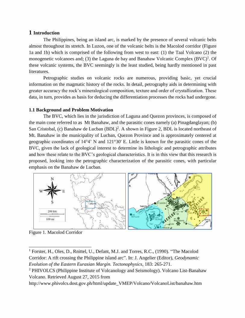
1 Introduction
The Philippines, being an island arc, is marked by the presence of several volcanic belts
almost throughout its stretch. In Luzon, one of the volcanic belts is the Macolod corridor (Figure
1a and 1b) which is comprised of the following from west to east: (1) the Taal Volcano (2) the
monogenetic volcanoes and; (3) the Laguna de bay and Banahaw Volcanic Complex (BVC)1. Of
these volcanic systems, the BVC seemingly is the least studied, being hardly mentioned in past
literatures.
Petrographic studies on volcanic rocks are numerous, providing basic, yet crucial
information on the magmatic history of the rocks. In detail, petrography aids in determining with
greater accuracy the rock’s mineralogical composition, texture and order of crystallization. These
data, in turn, provides as basis for deducing the differentiation processes the rocks had undergone.
1.1 Background and Problem Motivation
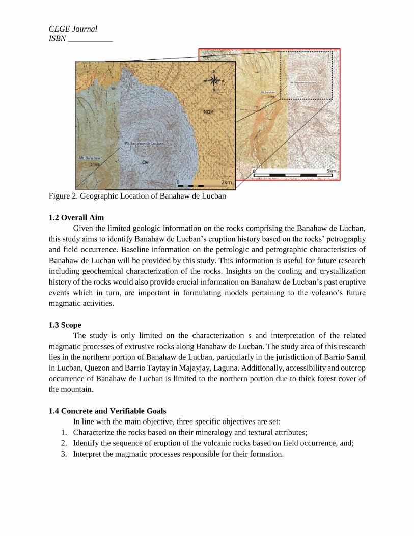
The BVC, which lies in the jurisdiction of Laguna and Quezon provinces, is composed of
the main cone referred to as Mt Banahaw, and the parasitic cones namely (a) Pinagdanglayan; (b)
San Cristobal, (c) Banahaw de Lucban (BDL)2. A shown in Figure 2, BDL is located northeast of
Mt. Banahaw in the municipality of Lucban, Quezon Province and is approximately centered at
geographic coordinates of 14°4’ N and 121°30' E. Little is known for the parasitic cones of the
BVC, given the lack of geological interest to determine its lithologic and petrographic attributes
and how these relate to the BVC’s geological characteristics. It is in this view that this research is
proposed, looking into the petrographic characterization of the parasitic cones, with particular
emphasis on the Banahaw de Lucban.
Figure 1. Macolod Corridor
__________________________ 1 Forster, H., Oles, D., Rnittel, U., Defant, M.J. and Torres, R.C., (1990). “The Macolod
Corridor: A rift crossing the Philippine island arc”. In: J. Angelier (Editor), Geodynamic
Evolution of the Eastern Eurasian Margin. Tectonophysics, 183: 265-271. 2 PHIVOLCS (Philippine Institute of Volcanology and Seismology). Volcano List-Banahaw
Volcano. Retrieved August 27, 2015 from
http://www.phivolcs.dost.gov.ph/html/update_VMEP/Volcano/VolcanoList/banahaw.htm
CEGE Journal
ISBN ___________
Figure 2. Geographic Location of Banahaw de Lucban
1.2 Overall Aim
Given the limited geologic information on the rocks comprising the Banahaw de Lucban,
this study aims to identify Banahaw de Lucban’s eruption history based on the rocks’ petrography
and field occurrence. Baseline information on the petrologic and petrographic characteristics of
Banahaw de Lucban will be provided by this study. This information is useful for future research
including geochemical characterization of the rocks. Insights on the cooling and crystallization
history of the rocks would also provide crucial information on Banahaw de Lucban’s past eruptive
events which in turn, are important in formulating models pertaining to the volcano’s future
magmatic activities.
1.3 Scope
The study is only limited on the characterization s and interpretation of the related
magmatic processes of extrusive rocks along Banahaw de Lucban. The study area of this research
lies in the northern portion of Banahaw de Lucban, particularly in the jurisdiction of Barrio Samil
in Lucban, Quezon and Barrio Taytay in Majayjay, Laguna. Additionally, accessibility and outcrop
occurrence of Banahaw de Lucban is limited to the northern portion due to thick forest cover of
the mountain.
1.4 Concrete and Verifiable Goals
In line with the main objective, three specific objectives are set:
1. Characterize the rocks based on their mineralogy and textural attributes;
2. Identify the sequence of eruption of the volcanic rocks based on field occurrence, and;
3. Interpret the magmatic processes responsible for their formation.
CEGE Journal
ISBN ___________
2 Review of Related work
Banahaw Volcanic Complex lies southwest of Luzon, east of Macolod. Holocene eruptions
of Mount Banahaw provided the sources for two youngest tephra layers: layers A (6 ka) and B (52
ka)3. which are compositionally made up of plagioclase and clinopyroxene. Mt Banahaw and its
surrounding areas are grouped into two morphological sectors. In the East, covering the beaches
of Mauban Quezon, is the Eastern Banahaw Sedimentary-Metamorphic Sector, while in the west
lies the Western Banahaw Volcanic Sector, which covers BVC4. The western volcanic sector is
further be subdivided into three major volcanic units based on the degree of erosion of the eruptive
centers, namely (1) Caliraya volcanic complex, (2) Malepunyo volcanic complex, and (3)
Banahaw volcanic complex5.
At least 4 distinct cone-building episodes are present in the Banahaw Volcanic Complex,
and each of this eruptive event comprise a separate volcanic group. . First is the Pinagdanglayan
volcanics, which is dominantly basaltic to andesitic tuff breccia. Second is San Cristobal Volcanics
pertaining to the most recent volcanic products of Mt. San Cristobal. The third volcanic group is
the Banahaw Volcanics, referring to the volcanic products of Mt Banahaw. The fourth volcanic
group formed the cone-complex of Mt. Banahaw de Lucban, which are collectively termed as
Lucban volcanics4.
In 1999, Banahaw de Lucban is identified as a Quaternary volcanic cone (Figure 2) that is
compositionally made of fine to medium grained andesite and/or basalt lava flow, overlying
Laguna formation6.
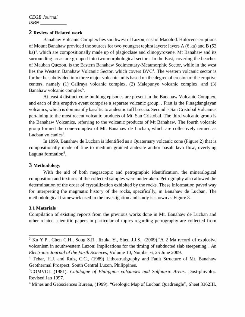
3 Methodology
With the aid of both megascopic and petrographic identification, the mineralogical
composition and textures of the collected samples were undertaken. Petrography also allowed the
determination of the order of crystallization exhibited by the rocks. These information paved way
for interpreting the magmatic history of the rocks, specifically, in Banahaw de Lucban. The
methodological framework used in the investigation and study is shown as Figure 3.
3.1 Materials
Compilation of existing reports from the previous works done in Mt. Banahaw de Lucban and
other related scientific papers in particular of topics regarding petrography are collected from
libraries
__________________________ 3 Ku Y.P., Chen C.H., Song S.R., Iizuka Y., Shen J.J.S., (2009)."A 2 Ma record of explosive
volcanism in southwestern Luzon: Implications for the timing of subducted slab steepening". An
Electronic Journal of the Earth Sciences, Volume 10, Number 6, 25 June 2009. 4 Tebar, H.J. and Ruiz, C.C., (1989) Lithostratigraphy and Fault Structure of Mt. Banahaw
Geothermal Prospect, South Central Luzon, Philippines. 5COMVOL (1981). Catalogue of Philippine volcanoes and Solfataric Areas. Dost-phivolcs.
Revised Jan 1997. 6 Mines and Geosciences Bureau, (1999). “Geologic Map of Lucban Quadrangle”, Sheet 3362III.
CEGE Journal
ISBN ___________
libraries of Mapúa Institute of Technology (MIT) and Philippine Institute of Volcanology and
Seismology (PHIVOLCS). Additional journals and articles are obtained from EBSCO (Elton B.
Stephens Co.) Discovery Service of MIT Library and other internet sources.
Figure 3. Conceptual framework
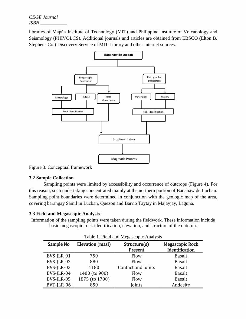
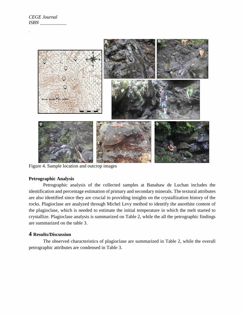
3.2 Sample Collection
Sampling points were limited by accessibility and occurrence of outcrops (Figure 4). For
this reason, such undertaking concentrated mainly at the northern portion of Banahaw de Lucban.
Sampling point boundaries were determined in conjunction with the geologic map of the area,
covering barangay Samil in Lucban, Quezon and Barrio Taytay in Majayjay, Laguna.
3.3 Field and Megascopic Analysis.
Information of the sampling points were taken during the fieldwork. These information include
basic megascopic rock identification, elevation, and structure of the outcrop.
Table 1. Field and Megascopic Analysis
Sample No Elevation (masl) Structure(s) Present
Megascopic Rock Identification
BVS-JLR-01 750 Flow Basalt BVS-JLR-02 880 Flow Basalt BVS-JLR-03 1180 Contact and joints Basalt BVS-JLR-04 1400 (to 900) Flow Basalt BVS-JLR-05 1875 (to 1700) Flow Basalt BVT-JLR-06 850 Joints Andesite
CEGE Journal
ISBN ___________
.
Figure 4. Sample location and outcrop images
Petrographic Analysis
Petrographic analysis of the collected samples at Banahaw de Lucban includes the
identification and percentage estimation of primary and secondary minerals. The textural attributes
are also identified since they are crucial in providing insights on the crystallization history of the
rocks. Plagioclase are analyzed through Michel Levy method to identify the anorthite content of
the plagioclase, which is needed to estimate the initial temperature in which the melt started to
crystallize. Plagioclase analysis is summarized on Table 2, while the all the petrographic findings
are summarized on the table 3.
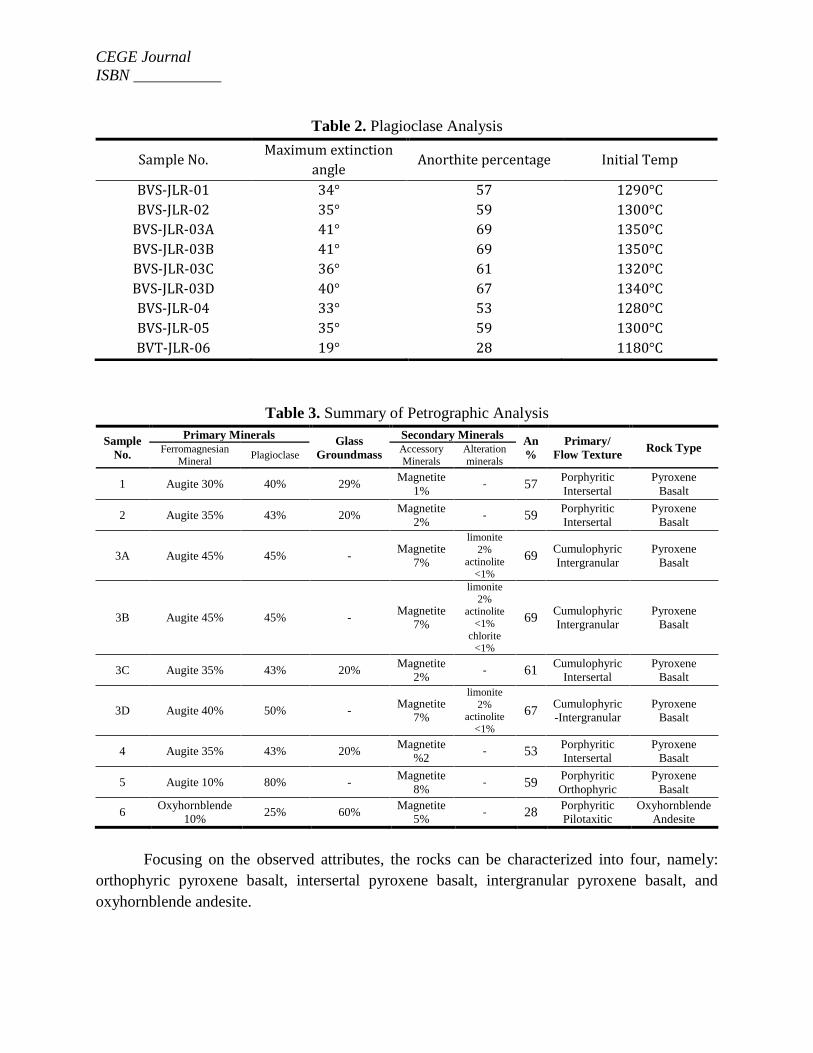
4 Results/Discussion
The observed characteristics of plagioclase are summarized in Table 2, while the overall
petrographic attributes are condensed in Table 3.
CEGE Journal
ISBN ___________
Table 2. Plagioclase Analysis
Table 3. Summary of Petrographic Analysis
Sample
No.
Primary Minerals Glass
Groundmass
Secondary Minerals An
%
Primary/
Flow Texture Rock Type Ferromagnesian
Mineral Plagioclase
Accessory
Minerals
Alteration
minerals
1 Augite 30% 40% 29% Magnetite
1% - 57
Porphyritic
Intersertal
Pyroxene
Basalt
2 Augite 35% 43% 20% Magnetite
2% - 59
Porphyritic
Intersertal
Pyroxene
Basalt
3A Augite 45% 45% - Magnetite
7%
limonite
2%
actinolite <1%
69 Cumulophyric
Intergranular
Pyroxene
Basalt
3B Augite 45% 45% - Magnetite
7%
limonite
2% actinolite
<1%
chlorite <1%
69 Cumulophyric
Intergranular
Pyroxene
Basalt
3C Augite 35% 43% 20% Magnetite
2% - 61
Cumulophyric
Intersertal
Pyroxene
Basalt
3D Augite 40% 50% - Magnetite
7%
limonite
2% actinolite
<1%
67 Cumulophyric
-Intergranular
Pyroxene
Basalt
4 Augite 35% 43% 20% Magnetite
%2 - 53
Porphyritic
Intersertal
Pyroxene
Basalt
5 Augite 10% 80% - Magnetite
8% - 59
Porphyritic
Orthophyric
Pyroxene
Basalt
6 Oxyhornblende
10% 25% 60%
Magnetite
5% - 28
Porphyritic
Pilotaxitic
Oxyhornblende
Andesite
Focusing on the observed attributes, the rocks can be characterized into four, namely:
orthophyric pyroxene basalt, intersertal pyroxene basalt, intergranular pyroxene basalt, and
oxyhornblende andesite.
Sample No. Maximum extinction
angle Anorthite percentage Initial Temp
BVS-JLR-01 34° 57 1290°C
BVS-JLR-02 35° 59 1300°C
BVS-JLR-03A 41° 69 1350°C
BVS-JLR-03B 41° 69 1350°C
BVS-JLR-03C 36° 61 1320°C
BVS-JLR-03D 40° 67 1340°C
BVS-JLR-04 33° 53 1280°C
BVS-JLR-05 35° 59 1300°C
BVT-JLR-06 19° 28 1180°C
CEGE Journal
ISBN ___________
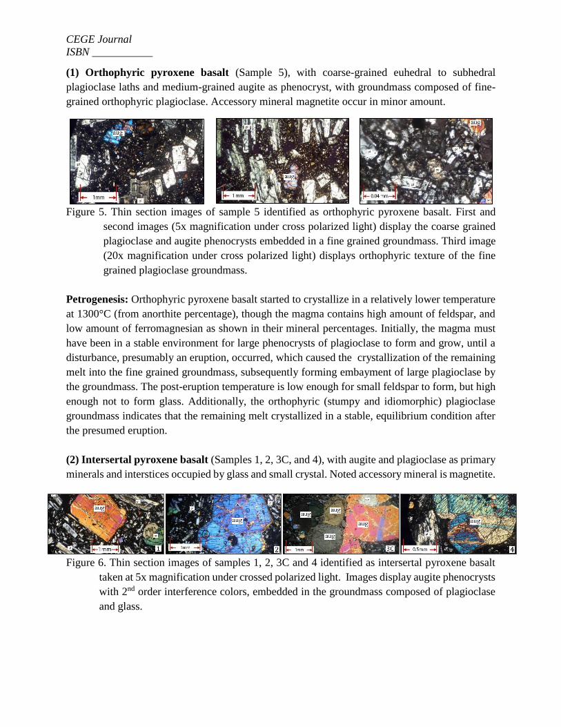
(1) Orthophyric pyroxene basalt (Sample 5), with coarse-grained euhedral to subhedral
plagioclase laths and medium-grained augite as phenocryst, with groundmass composed of fine-
grained orthophyric plagioclase. Accessory mineral magnetite occur in minor amount.
Figure 5. Thin section images of sample 5 identified as orthophyric pyroxene basalt. First and
second images (5x magnification under cross polarized light) display the coarse grained
plagioclase and augite phenocrysts embedded in a fine grained groundmass. Third image
(20x magnification under cross polarized light) displays orthophyric texture of the fine
grained plagioclase groundmass.
Petrogenesis: Orthophyric pyroxene basalt started to crystallize in a relatively lower temperature
at 1300°C (from anorthite percentage), though the magma contains high amount of feldspar, and
low amount of ferromagnesian as shown in their mineral percentages. Initially, the magma must
have been in a stable environment for large phenocrysts of plagioclase to form and grow, until a
disturbance, presumably an eruption, occurred, which caused the crystallization of the remaining
melt into the fine grained groundmass, subsequently forming embayment of large plagioclase by
the groundmass. The post-eruption temperature is low enough for small feldspar to form, but high
enough not to form glass. Additionally, the orthophyric (stumpy and idiomorphic) plagioclase
groundmass indicates that the remaining melt crystallized in a stable, equilibrium condition after
the presumed eruption.
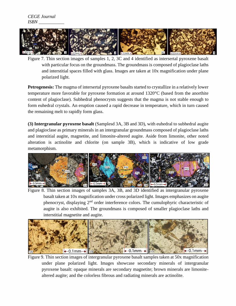
(2) Intersertal pyroxene basalt (Samples 1, 2, 3C, and 4), with augite and plagioclase as primary
minerals and interstices occupied by glass and small crystal. Noted accessory mineral is magnetite.
Figure 6. Thin section images of samples 1, 2, 3C and 4 identified as intersertal pyroxene basalt
taken at 5x magnification under crossed polarized light. Images display augite phenocrysts
with 2nd order interference colors, embedded in the groundmass composed of plagioclase
and glass.
CEGE Journal
ISBN ___________
Figure 7. Thin section images of samples 1, 2, 3C and 4 identified as intersertal pyroxene basalt
with particular focus on the groundmass. The groundmass is composed of plagioclase laths
and interstitial spaces filled with glass. Images are taken at 10x magnification under plane
polarized light.
Petrogenesis: The magma of intersertal pyroxene basalts started to crystallize in a relatively lower
temperature more favorable for pyroxene formation at around 1320°C (based from the anorthite
content of plagioclase). Subhedral phenocrysts suggests that the magma is not stable enough to
form euhedral crystals. An eruption caused a rapid decrease in temperature, which in turn caused
the remaining melt to rapidly form glass.
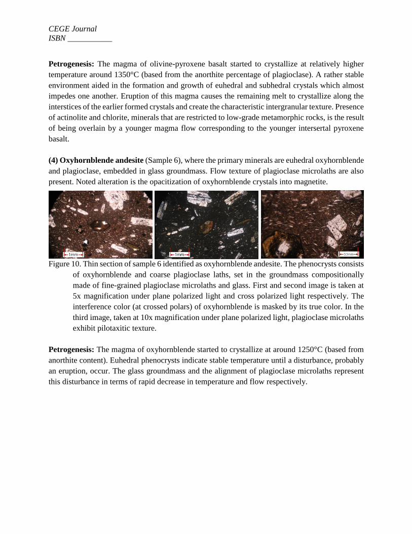
(3) Intergranular pyroxene basalt (Samplesd 3A, 3B and 3D), with euhedral to subhedral augite
and plagioclase as primary minerals in an intergranular groundmass composed of plagioclase laths
and interstitial augite, magnetite, and limonite-altered augite. Aside from limonite, other noted
alteration is actinolite and chlorite (on sample 3B), which is indicative of low grade
metamorphism.
Figure 8. Thin section images of samples 3A, 3B, and 3D identified as intergranular pyroxene
basalt taken at 10x magnification under cross polarized light. Images emphasizes on augite
phenocryst, displaying 2nd order interference colors. The cumulophyric characteristic of
augite is also exhibited. The groundmass is composed of smaller plagioclase laths and
interstitial magnetite and augite.
Figure 9. Thin section images of intergranular pyroxene basalt samples taken at 50x magnification
under plane polarized light. Images showcase secondary minerals of intergranular
pyroxene basalt: opaque minerals are secondary magnetite; brown minerals are limonite-
altered augite; and the colorless fibrous and radiating minerals are actinolite.
CEGE Journal
ISBN ___________
Petrogenesis: The magma of olivine-pyroxene basalt started to crystallize at relatively higher
temperature around 1350°C (based from the anorthite percentage of plagioclase). A rather stable
environment aided in the formation and growth of euhedral and subhedral crystals which almost
impedes one another. Eruption of this magma causes the remaining melt to crystallize along the
interstices of the earlier formed crystals and create the characteristic intergranular texture. Presence
of actinolite and chlorite, minerals that are restricted to low-grade metamorphic rocks, is the result
of being overlain by a younger magma flow corresponding to the younger intersertal pyroxene
basalt.
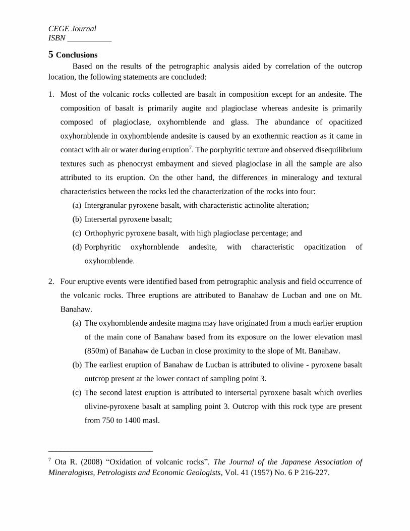
(4) Oxyhornblende andesite (Sample 6), where the primary minerals are euhedral oxyhornblende
and plagioclase, embedded in glass groundmass. Flow texture of plagioclase microlaths are also
present. Noted alteration is the opacitization of oxyhornblende crystals into magnetite.
Figure 10. Thin section of sample 6 identified as oxyhornblende andesite. The phenocrysts consists
of oxyhornblende and coarse plagioclase laths, set in the groundmass compositionally
made of fine-grained plagioclase microlaths and glass. First and second image is taken at
5x magnification under plane polarized light and cross polarized light respectively. The
interference color (at crossed polars) of oxyhornblende is masked by its true color. In the
third image, taken at 10x magnification under plane polarized light, plagioclase microlaths
exhibit pilotaxitic texture.
Petrogenesis: The magma of oxyhornblende started to crystallize at around 1250°C (based from
anorthite content). Euhedral phenocrysts indicate stable temperature until a disturbance, probably
an eruption, occur. The glass groundmass and the alignment of plagioclase microlaths represent
this disturbance in terms of rapid decrease in temperature and flow respectively.
CEGE Journal
ISBN ___________
5 Conclusions
Based on the results of the petrographic analysis aided by correlation of the outcrop
location, the following statements are concluded:
1. Most of the volcanic rocks collected are basalt in composition except for an andesite. The
composition of basalt is primarily augite and plagioclase whereas andesite is primarily
composed of plagioclase, oxyhornblende and glass. The abundance of opacitized
oxyhornblende in oxyhornblende andesite is caused by an exothermic reaction as it came in
contact with air or water during eruption7. The porphyritic texture and observed disequilibrium
textures such as phenocryst embayment and sieved plagioclase in all the sample are also
attributed to its eruption. On the other hand, the differences in mineralogy and textural
characteristics between the rocks led the characterization of the rocks into four:
(a) Intergranular pyroxene basalt, with characteristic actinolite alteration;
(b) Intersertal pyroxene basalt;
(c) Orthophyric pyroxene basalt, with high plagioclase percentage; and
(d) Porphyritic oxyhornblende andesite, with characteristic opacitization of
oxyhornblende.
2. Four eruptive events were identified based from petrographic analysis and field occurrence of
the volcanic rocks. Three eruptions are attributed to Banahaw de Lucban and one on Mt.
Banahaw.
(a) The oxyhornblende andesite magma may have originated from a much earlier eruption
of the main cone of Banahaw based from its exposure on the lower elevation masl
(850m) of Banahaw de Lucban in close proximity to the slope of Mt. Banahaw.
(b) The earliest eruption of Banahaw de Lucban is attributed to olivine - pyroxene basalt
outcrop present at the lower contact of sampling point 3.
(c) The second latest eruption is attributed to intersertal pyroxene basalt which overlies
olivine-pyroxene basalt at sampling point 3. Outcrop with this rock type are present
from 750 to 1400 masl.
__________________________
7 Ota R. (2008) “Oxidation of volcanic rocks”. The Journal of the Japanese Association of
Mineralogists, Petrologists and Economic Geologists, Vol. 41 (1957) No. 6 P 216-227.
CEGE Journal
ISBN ___________
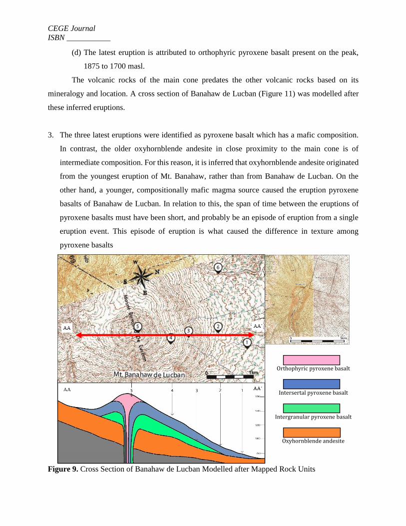
(d) The latest eruption is attributed to orthophyric pyroxene basalt present on the peak,
1875 to 1700 masl.
The volcanic rocks of the main cone predates the other volcanic rocks based on its
mineralogy and location. A cross section of Banahaw de Lucban (Figure 11) was modelled after
these inferred eruptions.
3. The three latest eruptions were identified as pyroxene basalt which has a mafic composition.
In contrast, the older oxyhornblende andesite in close proximity to the main cone is of
intermediate composition. For this reason, it is inferred that oxyhornblende andesite originated
from the youngest eruption of Mt. Banahaw, rather than from Banahaw de Lucban. On the
other hand, a younger, compositionally mafic magma source caused the eruption pyroxene
basalts of Banahaw de Lucban. In relation to this, the span of time between the eruptions of
pyroxene basalts must have been short, and probably be an episode of eruption from a single
eruption event. This episode of eruption is what caused the difference in texture among
pyroxene basalts
Figure 9. Cross Section of Banahaw de Lucban Modelled after Mapped Rock Units
Met
ers
abo
ve
Orthophyric pyroxene basalt
Intersertal pyroxene basalt
Intergranular pyroxene basalt
Oxyhornblende andesite
CEGE Journal
ISBN ___________
References
1. Forster, H., Oles, D., Rnittel, U., Defant, M.J. and Torres, R.C., (1990). “The Macolod
Corridor: A rift crossing the Philippine island arc”. In: J. Angelier (Editor), Geodynamic
Evolution of the Eastern Eurasian Margin. Tectonophysics, 183: 265-271.
2. PHIVOLCS (Philippine Institute of Volcanology and Seismology). Volcano List-Banahaw
Volcano. Retrieved August 27, 2015 from
http://www.phivolcs.dost.gov.ph/html/update_VMEP/Volcano/VolcanoList/banahaw.htm
3. Ku Y.P., Chen C.H., Song S.R., Iizuka Y., Shen J.J.S., (2009)."A 2 Ma record of explosive
volcanism in southwestern Luzon: Implications for the timing of subducted slab steepening".
An Electronic Journal of the Earth Sciences, Volume 10, Number 6, 25 June 2009.
4. Tebar, H.J. and Ruiz, C.C., (1989) Lithostratigraphy and Fault Structure of Mt. Banahaw
Geothermal Prospect, South Central Luzon, Philippines.
5. COMVOL (1981). Catalogue of Philippine volcanoes and Solfataric Areas. Dost-phivolcs.
Revised Jan 1997.
6. Mines and Geosciences Bureau, (1999). “Geologic Map of Lucban Quadrangle”, Sheet
3362III.
7. Ota R. (2008) “Oxidation of volcanic rocks”. The Journal of the Japanese Association of
Mineralogists, Petrologists and Economic Geologists, Vol. 41 (1957) No. 6 P 216-227.