cemex uk operations ltd
TRANSCRIPT
RUGELEY QUARRY RUGELEY
STAFFORDSHIRE
ARCHAEOLOGICAL EVALUATION
For
CEMEX UK OPERATIONS LTD
CA PROJECT: 2713 CA REPORT: 08234
DECEMBER 2008
RUGELEY QUARRY
RUGELEY STAFFORDSHIRE
ARCHAEOLOGICAL EVALUATION
CA PROJECT: 2713 CA REPORT: 08234
prepared by Sian Reynish, Project Supervisor
date 23 January 2009
checked by Richard Young, Project Manager
date 23 January 2009
approved by Mark Collard, Head of Contracts
signed
date 23 January 2009
issue 02
This report is confidential to the client. Cotswold Archaeology accepts no responsibility or liability to any third party to whom this report, or any part of it, is made known. Any such party relies upon this report entirely at their own risk.
No part of this report may be reproduced by any means without permission.
© Cotswold Archaeology Building 11, Kemble Enterprise Park, Kemble, Cirencester, Gloucestershire, GL7 6BQ
Tel. 01285 771022 Fax. 01285 771033 E-mail: [email protected]

© Cotswold Archaeology
Rugeley Quarry, Rugeley, Staffordshire: Archaeological Evaluation
CONTENTS
SUMMARY........................................................................................................................ 2
1. INTRODUCTION ................................................................................................. 3
2. RESULTS (FIGS 2-3) .......................................................................................... 5
3. DISCUSSION....................................................................................................... 6
4. CA PROJECT TEAM ........................................................................................... 7
5. REFERENCES .................................................................................................... 7
APPENDIX A: CONTEXT DESCRIPTIONS ..................................................................... 8
APPENDIX B: OASIS REPORT FORM............................................................................ 9
LIST OF ILLUSTRATIONS
Fig. 1 Site location plan (1:25,000)
Fig. 2 Trench location plan (1:750)
Fig. 3 Sections (1:20)
1

© Cotswold Archaeology Rugeley Quarry, Rugeley, Staffordshire: Archaeological Evaluation
SUMMARY
Project Name: Rugeley Quarry
Location: Rugeley, Staffordshire
NGR: SK 0045 1865
Type: Evaluation
Date: 3–4 November 2008
Planning Reference: CH.00/0577 and S.400/18
Location of Archive: To be deposited with The Potteries Museum, Staffordshire
Accession Number: 2008.LH.53
Site Code: RQR 08
An archaeological evaluation was undertaken by Cotswold Archaeology in November 2008
at the request of CEMEX UK Operations Ltd at Rugeley Quarry, Rugeley, Staffordshire.
Three trenches were excavated across the lines of two possible banks associated with
Wolseley Park, which was created as a deerpark at the end of the 15th Century.
The evaluation demonstrated that one of the banks survives as an earthwork, with an
adjacent ditch along part of its length. The other bank does not survive as an earthwork, but
is visible below the subsoil. No dating evidence was recovered during the evaluation, but the
form and location of the boundaries is consistent with them having formed part of the
deerpark.
2

© Cotswold Archaeology Rugeley Quarry, Rugeley, Staffordshire: Archaeological Evaluation
1. INTRODUCTION
1.1 In November 2008 Cotswold Archaeology (CA) carried out an archaeological
evaluation for CEMEX UK Operations Ltd at Rugeley Quarry, Rugeley, Staffordshire
(centred on NGR: SK 0045 1865; Fig. 1). The evaluation was undertaken prior to the
proposed extension of the quarry.
1.2 The evaluation was carried out in accordance with a detailed Written Scheme of
Investigation (WSI) produced by CA (2008a) and approved by Stephen Dean,
Historic Environment Officer (Archaeology), the archaeological advisor to Staffordshire
County Council (SCC). The fieldwork also followed the Standard and Guidance for
Archaeological Field Evaluation issued by the Institute of Field Archaeologists
(2001) and the Management of Archaeological Projects (English Heritage 1991).
The fieldwork was monitored by Mr Dean.
The site
1.3 The site comprises a triangle of mature woodland within the Wolseley Plain region of
Wolseley Park. It covers approximately 5.3ha and is bordered by the existing quarry
to the east and by Forestry Commission woodland to the north, south and west (Fig.
2). The site lies at approximately 169m AOD.
1.4 The underlying solid geology of the area is mapped as the Cannock Chase
Formation, also known as ‘Pebble Beds’, and part of the Triassic Sherwood
Sandstone Group (BGS 1982).
Archaeological background
1.5 The area of the proposed extension has been the subject of a previous planning
application for which a Cultural Heritage Statement was produced by Oxford
Archaeological Associates. The archaeological background presented below is based
on the findings of this report which is summarised within a report on fieldwork
undertaken by Oxford Archaeology at Rugeley Quarry in 2001 (OA 2001).
3

© Cotswold Archaeology Rugeley Quarry, Rugeley, Staffordshire: Archaeological Evaluation
1.6 The site lies within Wolseley Park, which was created as a deerpark at the end of
the 15th Century. It is probable that a ditch and bank would have delineated the
park boundary. Within the site itself earthwork banks and ditches were recorded
during the fieldwork undertaken by Oxford Archaeology in 2001 (OA 2001). These
were labelled banks 13 and 14 and it was suggested that they might represent
internal divisions within the park.
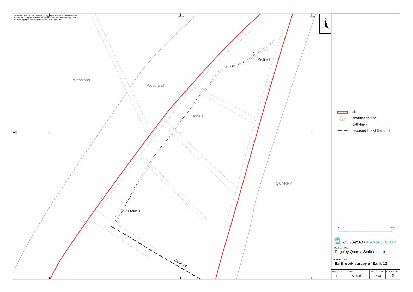
1.7 In September 2008 CA carried out an earthwork survey of the earthworks within the
site (CA 2008b). This demonstrated that bank 13 was a real archaeological feature
but that bank 14 had been levelled during the recent creation of a forest track.
Archaeological objectives
1.8 The objectives of the evaluation were to establish the character, quality, date and
extent of any archaeological remains surviving within the site. This information will
assist Staffordshire County Council in making an informed judgement on the
significance of the archaeological resource, and the likely impact upon it of the
proposed development.
Methodology
1.9 The fieldwork comprised the excavation of three trenches in the locations shown on
the attached plan (Fig. 2). Trenches 1 and 2 targeted bank 13 whilst trench 3
targeted the recorded location of bank 14. Trenches 1 and 2 measured 10m in
length whilst trench 3 measured 20m in length. All trenches were 0.9m wide. The
locations of trenches 2 and 3 were altered from those proposed in the WSI due to
the location of trees within the site.
1.10 All trenches were excavated by mechanical excavator equipped with a toothless
grading bucket. All machine excavation was undertaken under constant
archaeological supervision to the top of the first significant archaeological horizon or
the natural substrate, whichever was encountered first. Where archaeological
deposits were encountered they were excavated by hand in accordance with CA
Technical Manual 1: Fieldwork Recording Manual (2007).
4

© Cotswold Archaeology Rugeley Quarry, Rugeley, Staffordshire: Archaeological Evaluation
1.11 Deposits were assessed for their palaeoenvironmental potential in accordance with
CA Technical Manual 2: The Taking and Processing of Environmental and Other
Samples from Archaeological Sites (2003). No deposits were identified that required
sampling.
1.12 The archive from the evaluation is currently held by CA at their offices in Kemble
and will be deposited with The Potteries Museum, Staffordshire under accession
number 2008.LH.53. A summary of information from this project, set out within
Appendix B, will be entered onto the OASIS online database of archaeological
projects in Britain.
2. RESULTS (FIGS 2-5)
2.1 This section provides an overview of the evaluation results; detailed summaries of
the recorded contexts are to be found in Appendix A.
Trench 1 (Fig. 2 & 3)
2.2 The earliest encountered deposit was silty sand and gravel geological substrate
1003, exposed at 0.4m below present ground level (BPGL). This was overlain by a
5m wide and 0.5m high bank formed from redeposited natural 1002. The bank was
partially overlain by subsoil 1001 and was otherwise sealed by topsoil 1000.
Although the bank had been disturbed by tree roots, it survived as a north-
east/south-west aligned earthwork 3.5m wide and up to 0.6m high. No artefactual
material was recovered from any of the deposits within trench 1.
Trench 2 (Figs 2 & 4)
2.3 The earliest encountered deposit was silty sand and gravel geological substrate
2002, exposed at 0.4m BPGL. The natural substrate had been cut by north-
east/south-west aligned ditch 2006. This ditch was V-profiled and was 0.7m deep
and 1m wide (Fig. 3).
2.4 Along the eastern side of the ditch, the natural substrate was overlain by a sequence
of three deposits (2003-2005) which formed a bank 2.1m wide and 0.6m high. All of
these deposits were derived from the natural substrate, most probably as upcast
from the adjacent ditch.
5
© Cotswold Archaeology Rugeley Quarry, Rugeley, Staffordshire: Archaeological Evaluation
2.5 This banked material was partially overlain by subsoil 2001 and was otherwise
sealed by topsoil 2000. As within trench 1, the bank survived as a north-east/south-
west aligned earthwork 2.5m wide and up to 0.8m high. The ditch was partially filled
with material derived from the bank (2007 and 2008), and with part of the topsoil, but
also survived as a slight earthwork. No artefactual material was recovered from any
of the deposits within trench 2.
Trench 3 (Fig. 2 & 5)
2.6 The natural silty sand substrate, 3005, was exposed at 0.4m BPGL. It was overlain
by a sequence of three deposits (3002-3004) which formed the remains of a north-
west/south-east aligned bank. All of these deposits were derived from the natural
substrate. The banked material did not survive as an earthwork and was sealed by
subsoil 3001 which was itself sealed by topsoil 3000. No artefactual material was
recovered from any of these deposits.
3. DISCUSSION
3.1 The results of the evaluation confirm the presence of former boundaries along the
lines of banks 13 and 14. Although bank 14 does not survive as an earthwork, bank
13 does, and a ditch runs adjacent to its south-westernmost extent. Ditches and
banks were a common form of boundary associated with the management of
deerparks (Franklin 1989, 164, Rackham 1990, 125) and the boundaries identified
during the current works are therefore consistent with the site’s location within the
former Wolseley Park deerpark.
3.2 The management of deerparks was complex, often involving rotational use of
several parcels of land within the park for keeping deer, open grazing, growing
timber and growing firewood (Rackham 125-6). Uncompartmented deerparks
allowed access to deer at all times, with tree growth protected by pollarding. Other
parks were compartmented, being sub-divided by internal banks into coppices which
were fenced off during new growth to keep the deer out. A full understanding of the
role of the boundaries observed during the evaluation would need to take account of
the broader geography of Wolseley Park, but they are suggestive of a
compartmented deerpark.
6

© Cotswold Archaeology
7
Rugeley Quarry, Rugeley, Staffordshire: Archaeological Evaluation
4. CA PROJECT TEAM
Fieldwork was undertaken by Sian Reynish, assisted by Pippa Mitcheson. This
report was written by Sian Reynish, assisted by Pippa Mitcheson, with illustrations
prepared by Rachael Kershaw. The archive has been compiled by Sian Reynish and
Pippa Mitcheson, and prepared for deposition by Kathryn Price. The project was
managed for CA by Richard Young.
5. REFERENCES
BGS (British Geological Survey) 1982 Geological Survey of Great Britain, England and
Wales, Solid and Drift, Burton-upon-Trent, Sheet 140, 1:50,000
CA (Cotswold Archaeology) 2008a Rugeley Quarry, Rugeley, Staffordshire: Written Scheme
of Investigation for an Archaeological Evaluation
CA (Cotswold Archaeology) 2008b Rugeley Quarry, Rugeley, Staffordshire: Archaeological
Earthwork Survey. CA typescript report 08214
Franklin, P. 1989 ‘Thornbury Woodlands and Deer Parks, Part 1: the Earls of Gloucester’s
Deer Parks’ Trans Bristol Gloucestershire Archaeol Soc 107, 149-169
OA (Oxford Archaeology) 2001 Land at Rugeley Quarry, Cannock Chase, Staffordshire:
Archaeological walkover survey results and recommendations for geophysical
survey, unpublished OA report
Rackham, O. 1990 The History of the Countryside: the Full Fascinating Story of Britain’s
Landscape J. M. Dent and Sons Ltd, London

© Cotswold Archaeology Rugeley Quarry, Rugeley, Staffordshire: Archaeological Evaluation
APPENDIX A: CONTEXT DESCRIPTIONS
Trench 1 No. Type Description Width Depth
1000 Layer Topsoil: dark brown clay silt and overlying mulch N/A 0.26m
1001 Layer Subsoil: mid orangey brown sandy silt with common pebbles
N/A 0.20m
1002 Deposit Redeposited natural forming NE/SW embankment 6m 0.54m
1003 Layer Natural geology: pink orange silty sand and gravel N/A N/A
Trench 2 No. Type Description Width Depth
2000 Layer Topsoil: organic dark brown and black clay silt with overlying mulch
N/A 0.17m
2001 Layer Subsoil: mid orange brown sandy silt with common pebbles N/A 0.25m
2002 Layer Natural geology: mid reddish brown silty sand and gravel N/A N/A
2003 Deposit Redeposited natural forming NE/SW embankment 2.10m 0.18m
2004 Deposit Redeposited natural forming NE/SW embankment 2.10m 0.08m
2005 Deposit Redeposited natural forming NE/SW embankment 1.92m 0.34m
2006 Cut Linear ditch parallel to 2009 1.01m 0.48m
2007 Fill Primary fill of 2006, natural silting 0.30m 0.12m
2008 Fill Secondary fill to 2006, slumping of 2005 N/A 0.14m
2009 Feature Earth bank made up of 2003, 2004 and 2005 2.10m 0.60m
Trench 3 No. Type Description Width Depth
3000 Layer Topsoil: organic dark brown and black clay silt with common pebbles
N/A 0.20m
3001 Layer Subsoil: mid brown clay sand N/A 0.18m
3002 Deposit Redeposited natural N/A 0.14m
3003 Deposit Redeposited natural N/A 0.09m
3004 Deposit Redeposited natural N/A 0.14m
3005 Layer Natural geology: pink orange silty sand and gravel N/A N/A
3006 Feature Remnant of earth bank made up of 3002, 3003 and 3004 N/A 0.37m
8
© Cotswold Archaeology
9
Rugeley Quarry, Rugeley, Staffordshire: Archaeological Evaluation
APPENDIX B: OASIS REPORT FORM
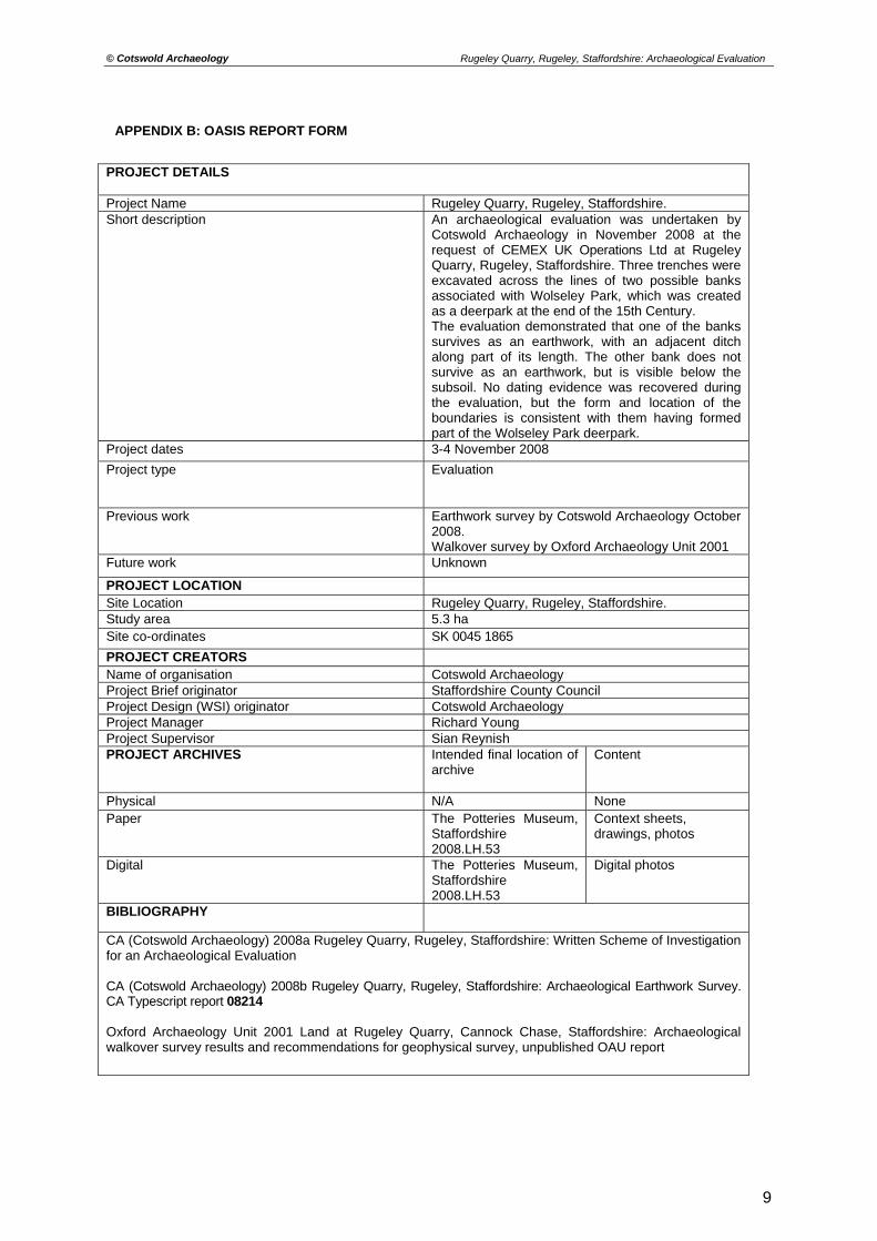
PROJECT DETAILS Project Name Rugeley Quarry, Rugeley, Staffordshire. Short description
An archaeological evaluation was undertaken by Cotswold Archaeology in November 2008 at the request of CEMEX UK Operations Ltd at Rugeley Quarry, Rugeley, Staffordshire. Three trenches were excavated across the lines of two possible banks associated with Wolseley Park, which was created as a deerpark at the end of the 15th Century. The evaluation demonstrated that one of the banks survives as an earthwork, with an adjacent ditch along part of its length. The other bank does not survive as an earthwork, but is visible below the subsoil. No dating evidence was recovered during the evaluation, but the form and location of the boundaries is consistent with them having formed part of the Wolseley Park deerpark.
Project dates 3-4 November 2008
Project type
Evaluation
Previous work
Earthwork survey by Cotswold Archaeology October 2008. Walkover survey by Oxford Archaeology Unit 2001
Future work Unknown
PROJECT LOCATION Site Location Rugeley Quarry, Rugeley, Staffordshire. Study area 5.3 ha Site co-ordinates SK 0045 1865
PROJECT CREATORS Name of organisation Cotswold Archaeology Project Brief originator Staffordshire County Council Project Design (WSI) originator Cotswold Archaeology Project Manager Richard Young Project Supervisor Sian Reynish PROJECT ARCHIVES Intended final location of
archive
Content
Physical N/A None Paper The Potteries Museum,
Staffordshire 2008.LH.53
Context sheets, drawings, photos
Digital The Potteries Museum, Staffordshire 2008.LH.53
Digital photos
BIBLIOGRAPHY
CA (Cotswold Archaeology) 2008a Rugeley Quarry, Rugeley, Staffordshire: Written Scheme of Investigation for an Archaeological Evaluation CA (Cotswold Archaeology) 2008b Rugeley Quarry, Rugeley, Staffordshire: Archaeological Earthwork Survey. CA Typescript report 08214 Oxford Archaeology Unit 2001 Land at Rugeley Quarry, Cannock Chase, Staffordshire: Archaeological walkover survey results and recommendations for geophysical survey, unpublished OAU report

Staffordshire
PROJECT TITLE
FIGURE TITLE
N
SCALEDRAWN BY PROJECT NO. FIGURE NO.
COTSWOLD ARCHAEOLOGY
0 2.5km
Reproduced from the 1998 Ordnance Survey Explorer map with the permissionof Ordnance Survey on behalf of The Controller of Her Majesty's Stationery Office Crown copyright Cotswold Archaeological Trust 100002109 c
Rugeley Quarry, Staffordshire
Site location plan
1:25,000@A4 2713RK 1
PROJECT TITLE
FIGURE TITLE
N
COTSWOLD ARCHAEOLOGY
SCALEDRAWN BY PROJECT NO. FIGURE NO.
0 40 m
Rugeley Quarry, Staffordshire
Earthwork survey of Bank 13
Reproduced from the 2008 Ordnance Survey Mastermap map with the permissionof Ordnance Survey on behalf of The Controller of Her Majesty's Stationery Office Crown copyright Cotswold Archaeological Trust 100002109 c
1:750@A3 2713RL 2
WoodlandWoodland
QUARRY
Bank 13site
obstructing tree
path/track
recorded line of Bank 14
Bank 14
400400 400500 40060031
8800
Profile 1
Profile 2

PROJECT TITLE
FIGURE TITLE
COTSWOLD ARCHAEOLOGY
SCALEDRAWN BY PROJECT NO. FIGURE NO.
Profile 2
NE SE
Profile 1
NE SE
Rugeley Quarry, Staffordshire
Indicative profiles of surveyed feature
Not to scale 2713RL 3