cenozoic sedimentary records of climate-tectonic coupling ... · review open access cenozoic...
TRANSCRIPT

REVIEW Open Access
Cenozoic sedimentary records of climate-tectonic coupling in the Western HimalayaPeter D. Clift1,2
Abstract
Sedimentary archives in the Himalayan foreland basin and Indus submarine fan provide the most detailed recordsof how changing monsoon strength may have affected erosion and the development of tectonic structures in thewestern Himalaya during the Neogene. Muscovite Ar-Ar ages show that fast exhumation of the Greater Himalaya wasearlier in the west (20–35 Ma) than in the central Himalaya (10–25 Ma), probably driven by progressive lithospheric slabtearing that caused both rock uplift and an intensified summer monsoon to start earlier in the western Himalaya. Ratesof exhumation reduced after ~ 17 Ma as uplift also slowed, apparently unrelated to climate change. However, furtherreduction at 6–8 Ma coincided with a time of weakening summer rains, as shown by carbon isotope data from theforeland and hematite-goethite records from ODP Site 730 on the Oman margin. Coming at a time of stronger winds,this drying was linked to global climatic cooling. Weakening of Late Miocene monsoon rains coincided with a southwardmigration of the ITCZ and faster erosion of the Lesser rather than Greater Himalaya. Unroofing of the Inner Lesser Himalaya,starting after 9 Ma, followed as a consequence of duplex formation enabled by focused erosion, although widespreadexposure of that range was delayed until after 6 Ma. Inner Lesser Himalayan exposure, combined with unroofing of theNanga Parbat Massif, caused a decrease in average εNd values of Indus River sediment after 5 Ma, rather than large-scaledrainage capture.
Keywords: Monsoon, Climate-tectonic, Himalaya, Erosion, Exhumation, Arabian Sea, Foreland basin, Provenance,Geochemistry, Cenozoic, Weathering
IntroductionThe building of high topography following the collision ofIndia with Eurasia sometime in the early Cenozoic is pro-posed to have played a fundamental role in strengtheningthe Asian monsoon in South and East Asia (Kutzbachet al. 1993; Molnar et al. 1993). In turn, the monsoonclimate is believed to feed back on the development of themountains via surface processes and to partially controlthe tectonic evolution of the fold belts that have developedsince the time of initial India-Eurasia collision (Clift et al.2008; Whipple 2009; Willett 1999). In doing so, theseinteractions between the solid Earth and the atmosphererepresent one of the world’s great natural laboratories forstudying the interplay of climate and tectonics over longperiods of geological time. In particular, the WesternHimalaya are a classic example of this interaction, despite
being on the NW margin of the monsoon rainfall, whichis centered instead around the Bay of Bengal. In fact,because of their location on the edge of the monsoonregion, the Western Himalaya are more sensitive tochanges in rainfall as monsoon precipitation waxed andwaned. This area also has the advantage of havingrelatively well-documented, long-duration, marine paleo-ceanographic records (Prell et al. 1992; Kroon et al. 1991;Gupta et al. 2015), which can be compared readily withcontemporaneous continental records.In this review, I evaluate the evidence linking the climatic
development of SW Asia to the processes of mountainbuilding in the adjacent ranges of the Himalaya andKarakoram (Fig. 1), exploiting the sedimentary recordpreserved in the terrestrial and marine basins. This allowsboth the processes of erosion, as well as the environmentalconditions that have affected the region since ~ 25 Ma tobe compared. I focus on the Miocene to present, becausethis is the time period over which we have more completerecords of terrestrial erosion and environmental conditions
Correspondence: [email protected] of Geology and Geophysics, Louisiana State University, BatonRouge, LA 70803, USA2School of Geography Science, Nanjing Normal University, Nanjing 210023,China
Progress in Earth and Planetary Science
© The Author(s). 2017 Open Access This article is distributed under the terms of the Creative Commons Attribution 4.0International License (http://creativecommons.org/licenses/by/4.0/), which permits unrestricted use, distribution, andreproduction in any medium, provided you give appropriate credit to the original author(s) and the source, provide a link tothe Creative Commons license, and indicate if changes were made.
Clift Progress in Earth and Planetary Science (2017) 4:39 DOI 10.1186/s40645-017-0151-8

(Burbank et al. 1996; Najman 2006). It is also the timeperiod for which new matching marine records are nowavailable from scientific ocean drilling in the Arabian Sea(Pandey et al. 2015). Although climate-tectonic interactionsmay go back much further into the Paleogene, presently,there are no suitable sedimentary sequences in SW Asiathat allow testing of whether the monsoon is really mucholder than the Miocene and whether the onset of mountainbuilding immediately after India-Eurasia collision waslinked to early Eocene intensification of summer rainfall, ashas been proposed in some parts of South and East Asia(Licht et al. 2014).
The Indus River BasinMuch of the evidence constraining erosion and envir-onmental conditions is preserved in the fill of thesedimentary basins of SW Asia, which have been sup-plied by the erosional load carried by the Indus Riverand its various tributaries (Fig. 1). This drainagesystem is the only major system in the western Hima-laya (with the exception of the Oxus/Amu Daryaflowing north from the Pamir) and comprises a trunkstream that originates in western Tibet that thenflows westward along the Neotethyan Indus SutureZone before turning south around the western syn-taxis (Nanga Parbat) and heading to the Arabian Sea
where it has supplied the material to construct thesecond largest sediment mass in the modern oceans,the Indus Submarine Fan (Fig. 2) (Clift et al. 2001;Naini and Kolla 1982; Kolla and Coumes 1987). TheIndus Fan stretches > 1500 km from the coast ofPakistan into the Indian Ocean and comprises ~ 4.5 ×10⁶ km3 of sediment, around a third of the size ofthe neighboring Bengal Fan.On the eastern side of the drainage, the Indus River
(average trunk discharge 3.91 × 10⁶ m3/s) (Alizai et al.2011) is supplied by discharge from four large tributar-ies, the Jhellum (average discharge 9.9 × 10⁵ m3/s),Chenab (1.1 × 10⁶ m3/s), Ravi (2.6 × 10⁵ m3/s), and Sutlej(4.0 × 10⁵ m3/s) (Fig. 1) that largely derive their sedimentfrom the Greater and Lesser Himalaya before flowingacross the plains of the Punjab to join the mainstreamabout half way on its journey from the mountain frontto the sea (Inam et al. 2007). In doing so, these riversalso fill the foreland basin that borders the Himalaya ontheir southern flank. A smaller set of flexural basinsborders the Indus River to the west where the obliquecollision between the Indian Plate and Eurasia,represented by the Chaman Fault, has generated SE-pro-pagating thrust belts in the Kirthar and Sulaiman Ranges(Fig. 1) (Roddaz et al. 2011). There is little sediment sup-plied from the west into the Indus River because ofthe generally arid conditions. The major exception to
30˚
35˚
25˚
KabulKabul
New DelhiNew Delhi
Sutlej Ghaggar
Ghaggar
BeasBeas
RaviRavi
ChenabChenabJhelum
Jhelum
Indu
sIn
dus
PeshawarPeshawarIslamabadIslamabad
KarachiKarachi
ArabianArabianSeaSea
Indus
300 km
N
65˚ 70˚ 75˚
Thar Desert
Indus Marine A-1
SulaimanSulaimanRangesRanges
Kirt
hir
Kirt
hir
Ran
ges
Ran
ges
NP
JW
CH
JO
Karakoram
Greater Himalaya
Hindu
Kus
h
Punjab
PP
80˚
Tibet
India
Oman
Qunf
CochinArabianSea
Pakistan Nepal
MakranMakran
Fig. 1 Satellite image of the Indus Basin from Google Earth. Map shows the major tributaries and trunk stream of the Indus, together with themain ranges discussed in this study. PP—Potwar Plateau; CH—Chinji; NP—Nanga Parbat; JW—Jawalamukhi; JO—Jogindernagar
Clift Progress in Earth and Planetary Science (2017) 4:39 Page 2 of 22

this pattern is the Kabul River that brings sedimentfrom the Hindu Kush.
Reconstructing erosionIf we are to assess the degree to which climate orsolid Earth tectonic forces control the developmentof the Himalaya, then we need to derive independentrecords of how erosion and climate have evolvedover long periods of geological time, in order tocompare with the structural evolution of the moun-tains. This is most effectively done through detailedprovenance studies that attempt to reconstruct howpatterns and rates of erosion have changed throughtime, in order to determine whether changes in theseprocesses correlate with climatic events. This iseasier to do in the Indus River basin compared tomany areas because of the compositional diversity ofthe source terranes. Figure 3 shows the differentranges and tectonic blocks that comprise theWestern Himalaya and the associated ranges in theKarakoram and Hindu Kush. Each of these units hastheir own distinctive geological history and compos-itional characteristics that allow their influence onthe net flux of sediment to the Arabian Sea to beresolved. Because of differences in the timing oftectonic or magmatic events in each block, thesediments eroded from each tends to have uniquecharacteristics in terms of either geochemistry or the
age of mineral cooling through a variety of differentclosure temperatures (Hodges 2003).
Source terrainsThe Lesser, Greater, and Tethyan Himalaya compriserock units that were previously part of a Greater Indiaprior to its collision with Eurasia (Garzanti et al. 1987;Ali and Aitchison 2005). These units have some similar-ities in terms of their evolution prior to collision,although in general the rocks of the Lesser Himalayatend to represent older crust (DeCelles et al. 2000;Gehrels et al. 2011), which has been more recentlyexhumed to the surface than the high mountains of theGreater Himalaya. Those in turn have been metamor-phosed at higher temperatures and pressures comparedto the lower ranges to the south (Searle 1996; Hodgesand Silverberg 1988; Searle et al. 2006). The TethyanHimalaya represent weakly metamorphosed sedimentaryrocks whose origin was similar to the Greater Himalayain representing the former sedimentary cover to thenorthern margin of Greater India (Robertson andDegnan 1994; Zhang et al. 2012; Garzanti 1993). To thenorth of these mountains lies the primitive mafic rocksof the Kohistan magmatic arc (Bignold et al. 2006; Khanet al. 1997), believed to have been formed in an intra-oceanic subduction setting, which is the primarygeological unit within the Indus Suture Zone. In turn,the Kohistan Arc is juxtaposed along its northern edge
6˚
8˚
10˚
12˚
14˚
16˚
18˚
20˚
22˚
24˚
26˚
60˚ 62˚ 64˚ 66˚ 68˚ 70˚ 72˚ 74˚ 76˚ 78˚ 80˚58˚
IODP U1456
IODP U1457
Murray Ridge
Ow
en R
idge
Indus delta
Chagos-Laccadive R
idge
DeccanPlateau
Mumbai
Goa
Laxmi Ridge
Carlberg Ridge
KarachiMakran
23
24
25
26
27
26
24
23
Gop Rift
Arabian Basin
Laxmi
Basin
DSDP 219
DSDP 221
DSDP 222DSDP223
DSDP224
ODP720
Scientific drill sitesPossible continent-ocean boundary
Magnetic anomaly
Edge of Indus Fan?
?
?
?
?
?
?
??
?
?
ODP730
Indus Marine A-1
Pak-G2
Figu
re 4
Fig. 2 Shaded bathymetric map of the Arabian Sea showing the extent of the Indus Fan (Kolla and Coumes 1987), the location of scientific andindustrial boreholes discussed in this paper, and the main tectonic elements that bound the basin, especially the marine magnetic anomalies ofMiles and Roest (1993). Base map is from GeoMapApp
Clift Progress in Earth and Planetary Science (2017) 4:39 Page 3 of 22

against the Karakoram separated by the Shyok oceanicsuture zone (Robertson and Collins 2002; Dunlap andWysoczanski 2002). The Karakoram themselves repre-sent a Mesozoic continental magmatic arc that precededthe closure of this northern Tethyan ocean but contin-ued activity long after closure of the oceanic basin(Schärer et al. 1990; Searle et al. 1989; Fraser et al.2001). Equivalent rocks in the Hindu Kush have similar-ities with the Karakoram but are generally not asstrongly metamorphosed and have not experienced therecent high exhumation rates (Hildebrand et al.2000), which are partly linked to activity along theKarakoram Fault starting in the middle Miocene(Phillips et al. 2004).Another distinctive terrain within the Western
Himalaya is the Nanga Parbat Massif that forms thelinchpin of the Western Syntaxis (Fig. 1). This iswell known as being a region of exceptionally fastrock uplift and exhumation, making it the source ofyoung detritus into the Indus River (Zeitler et al.1989; Treloar et al. 2000). However, earlier work onthis system suggests that Nanga Parbat is lessimportant as a source of sediment into the Industhan its Eastern equivalent at Namche Barwe (Leeet al. 2003; Clift et al. 2002b). In summary, thevarious ranges within the Indus basin have unique
characteristics that allow their contribution to theerosional flux to be constrained if sufficient numbersof provenance proxies can be applied. Typically asingle proxy is less effective at resolving erosionalflux from a single tectonic block.
Marine sedimentary recordsThe vast majority (~ 66%) of the sediment eroded from theHimalaya since the Eocene lies in the Arabian Sea (Cliftet al. 2001), even if some of the sediment was diverted tothe west, into the Makran before the uplift of the MurrayRidge (Critelli et al. 1990). Although the region has beensurveyed by seismic profiles over the thickest part ofthe depocenter, the bulk of the submarine fan has notyet been covered by representative seismic profiles.More importantly, the fan stratigraphy has not beenpenetrated to its total depth anywhere except themost distal locations in the southern part of the Ara-bian basin, for example at Deep Sea Drilling Project(DSDP) Site 221 (Whitmarsh et al. 1974). Most re-cently, International Ocean Discovery Program(IODP) recovered two sections from the Laxmi Basin,offshore Western India, IODP Sites U1456 and U1457(Pandey et al. 2015). Although these provide relativelylong records extending to ~ 10.8 Ma, they are unableto provide an erosional record of the Western
70˚ 80˚
Northern Karakoram
Transhimalayan Arcs
Karakoram Batholith
Southern Karakoram
West Pakistan Ranges
Greater Himalayas
Siwalik Molasse
Lesser Himalayas Tethys Himalaya (Chamba)
Tethys Himalaya(Kashmir)
Indu
s
Sutlej
Beas
Ravi
Jhel
um
Ganges
Yam
unaTharDesert
Karachi
Hin
du K
ush Karakorum
Fault
Tibet35˚
30˚
25˚
N
0 100km
New Delhi
Sutlej
Sukkur
MCT
MBTMFT
Chenab
Ghaggar
Thatta
ISZ
Ladakh
Kohistan
Sulaiman
Kirt
har
CH
JO
JW
NP
Fig. 3 Geological map of the study area showing the major tectonic units that are eroded by the Indus River and its tributaries. Map is modifiedafter Garzanti et al. (2005). Rivers as shown in thick black lines. ISZ = Indus Suture Zone, MCT = Main Central Thrust, MBT =Main Boundary Thrustand MFT = Main Frontal Thrust. Sample locations are shown as filled circles. Thick black line shows major Himalayan tributaries. CH—Chinji;NP—Nanga Parbat; JW—Jawalamukhi; JO—Jogindernagar
Clift Progress in Earth and Planetary Science (2017) 4:39 Page 4 of 22

Himalaya back into the Paleogene. This is because oferosion of the fan in Laxmi Basin by the NatarajaSlide (mass transport deposit) that was deposited intothe basin at around 10.8 Ma (Calvès et al. 2015). Fur-thermore, the IODP drill sites are unable to provideage control even to the younger part of the sectionacross the proximal fan because they are separatedfrom the main Arabian Basin by the Laxmi Ridge,preventing correlation of the dated reflectors fromthese sites towards the main sediment mass offshorethe Indus River mouth.Close to the modern river mouth around 11 km of
sediment has been identified overlying igneous base-ment and carbonate sedimentary rocks (Clift et al.2002a; Naini and Kolla 1982). The age ofsedimentation here is only loosely controlled by in-dustrial drilling sites both under the continentalmargin at Indus Marine A-1 (Shuaib and TariqShuaib 1999), as well as in deeper water at PAK-G2(Fig. 4), which penetrated into Eocene carbonatesrelated to the early stages breakup of the ArabianSea. Although a detailed erosion budget is notpossible at the present time, it is possible to datethe onset of the construction of channel-leveecomplexes using the seismic and the industrialdrilling data. This indicates that the first channel-levee complexes were being built during the EarlyMiocene and suggest a significant increase insediment flux to the basin starting around that time(Clift et al. 2001; Droz and Bellaiche 1991). None-theless, several kilometers of sediment predate thesefeatures, indicating the longevity of the Indus Riveras the conveyor of sediment from the WesternHimalaya since before the Early Miocene.
Sedimentology and mineralogy of the Himalayan forelandbasinTo date most of the detailed reconstructions of erosionin the Western Himalaya have come from studies on-shore, principally in the Himalayan foreland basin. AsIndia has continued to move towards Eurasia, the platehas been flexed down by the weight of the subductingslab, as well as by the mountains resulting in a basin ap-proximately 5–6 km deep (Raiverman et al. 1983). Sec-tions of sediment from the basin have been progressivelyaccreted into the mountains as the thrust front migratedsouthwards so that they are preserved both in the Sub-Himalaya and the Siwalik hills that form the first signifi-cant topography north of the Main Frontal Thrust(MFT). Figure 5 shows a generalized stratigraphic sec-tion of the sedimentary sequence. About half of the cu-mulative thickness is comprised of the Siwalik Group,which is a coarsening-upward sequence of fluvial rocksthat date back to around 13 Ma (Burbank et al. 1996).These are principally dated through paleomagneticmethods coupled with radiometric dating of occasionalvolcanic ash beds that allow the depositional ages to beconstrained (Ojha et al. 2000; Tauxe and Opdyke 1982;Johnson et al. 1985; Meigs et al. 1995). The Siwalik Groupis divided into three different formations, with the UpperSiwalik being dominated by conglomerates of alluvial fansedimentary facies (Rao 1993).Although the coarsening-upward character might
suggest an increasing intensity of erosion, this need notnecessarily be the case because of the fact that any givenpoint in a foreland basin will progressively approach themountain front through time, as the Indian plate isunderthrust, resulting in a long-term coarsening up-wards even with constant erosional flux (DeCelles and
0
2
4
6
8
10
0 50 100 150 200 250 300 350 400 450 500 550 600 650
Dep
th (
km)
Two-
way
trav
el ti
me
(s)
Distance (km)SW
0
2
4
6
8
10
PAK-G2
a
b
Isolated carbonate platform (Paleogene)
Neogene Indus Sequence
Channel-levee system
PAK-G2
Paleogene Indus Sequence
NE
Fig. 4 NE-SW oriented seismic line TEPP207 through well PAK-G2, showing the original and interpreted sections. Modified from Calvès et al. (2008).See Fig. 2 for location
Clift Progress in Earth and Planetary Science (2017) 4:39 Page 5 of 22

Giles 1996). Those formations predating the SiwalikGroup can be divided into two groups separated by amajor unconformity of debatable duration but largelyspanning the Oligocene. At one extreme, the hiatusspans from 40 to 22 Ma (Najman 2006; Jain et al. 2009),while others argue for a break of ≤ 3 m.y. or even less(Bera et al. 2008; Raiverman and Raman 1971). Themuddy and carbonate rocks of the Subathu Formation atthe base of the foreland section overlie older sediment-ary rocks of the Indian Craton and have variously beeninterpreted as the products of sedimentation into anearly foreland basin (Najman et al. 2001; Najman et al.1997) or possibly into a back bulge location (i.e., on thedistal side of the flexural forebulge) (DeCelles et al.1998a). The Subathu sediments contain chrome spinelgrains that were likely eroded from the Indus SutureZone, presumably from ophiolites or magmatic unitssimilar to those seen in Kohistan (Najman andGarzanti 2000). The units deposited above the longOligocene (22–40 Ma) unconformity have a variety ofnames (Dagshai, Kasauli, Dharamsala, Murree andKamlial Formations in the western foreland basin),but essentially comprise increasingly sandy fluvialsedimentary rcoks.
Studies of heavy minerals in these rocks show the ap-pearance of garnet starting at about 20 Ma (Najman andGarzanti 2000; Sinha 1970), shortly after the onset ofthrusting along the Main Central Thrust at ~ 24 Ma(Stephenson et al. 2001; Catlos et al. 2001), which is atleast partly responsible for the exposure of the GreaterHimalayan Sequence, one of the possible sources. It ishowever highly debatable whether the garnet grains inthese sandstones were actually derived from these unitsbecause garnet is not unique to the Greater Himalaya. Itis noteworthy that going up-section a series of increasinglyhigh-grade metamorphic minerals were progressively inputinto the foreland basin. Staurolite appears in the LowerSiwalik Formation, after ~ 13 Ma (Fig. 5), while kyanitemakes its initial appearance in the Upper Miocene, withsillimanite being the most recent addition within thePleistocene Upper Siwalik Formation (Najman andGarzanti 2000). Sillimanite is formed at higher tempera-tures than kyanite, leading to the idea that this up-sectionevolution in detrital mineralogy reflects progressive unroof-ing of higher temperature source rocks. Quite what thosesources might be is not immediately clear because thecrystalline Inner Lesser Himalaya also comprise high-grademetamorphic rocks, similar in grade to some part of theGreater Himalaya (Célérier et al., 2009a, b). The presenceof Miocene leucogranites in the Greater Himalaya does,however, provide a contrast to the generally lowertemperature rocks of the sandwiching Lesser and TethyanHimalaya (Searle and Fryer 1986; Vidal et al. 1982),and their erosion might provide a key indicator ofGreater Himalayan erosion.
Isotopic constraints on evolving provenanceContrasting crustal ages and petrogenesis has resulted inmajor differences in isotopic character between thedifferent ranges of the Himalaya. In particular, Ndisotopes have been used to assess the origin of clasticsediments in the foreland basin and Indus Fan becauseof the large known compositional ranges in the sourcesand modern rivers (Clift et al. 2002b; Najman et al.2009; Clift and Blusztajn 2005; Ahmad et al. 2000;Whittington et al. 1999). Furthermore, the Nd isotoperatio (143Nd/144Nd) of clastic sediment is not affected bytransport or chemical weathering/diagenesis (Goldsteinand Jacobsen 1988). Nd isotope composition in partreflects the average age of the crust being eroded. Thedata plotted in this study are provided in Table 1.Here, I consider two isotope ratios (143Nd/144Nd) from
the Himalayan foreland, one at Chinji in Pakistan(Chirouze et al. 2015), close to the location where the IndusRiver crosses the MFT, and another at Jawalamukhi whichlies close to the Beas River (Fig. 1) (Najman et al. 2009).Each is expected to record the long-term evolution of theselocal river systems and thus the erosion of that part of the
Middle Siwalik11-4.5 Ma
Cum
ulat
ive
thic
knes
s (k
m)
0
10
9
8
7
6
5
4
3
1
2
Chromespinel
Subathu57-41.5 Ma
Garnet
Staurolite
Kyanite
Sillimanite
Dagshai<27-20 Ma
Kasauli>20-13 Ma
LowerDharamsala20-16.5 Ma
UpperDharamsala16.5-12.5 Ma
LowerSiwalik13-11 Ma
UpperSiwalik4.5-1 Ma
1.0 Ma
2.6 Ma
5.2 Ma
11 Ma
12.5 Ma
16.5 Ma
20 Ma
<27 Ma
DepositionalAge (Ma)
Heavyminerals
Formation Lithology
Fig. 5 Simplified stratigraphy of the western Himalayan foreland basinderived from the work of Jain et al. (2009), showing the generalcoarsening up-section and the appearance of a variety of higher grademetamorphic minerals that might be associated with the unroofing ofthe Greater and Inner Lesser Himalaya
Clift Progress in Earth and Planetary Science (2017) 4:39 Page 6 of 22

Table 1 Synthesis of published Nd isotope data used in this study, together with a reference to the original sources from whichthey were derived
Sample Age 143Nd/144Nd ± 2σ Depositional Age (Ma) εNd Source
224-10R-1, 140 cm Middle Eocene 0.512027 5 37.0 − 11.9 Clift and Blusztajn (2005)
224-10R-2, 49 cm Middle Eocene 0.512357 5 37.5 − 5.5 Clift and Blusztajn (2005)
224-11R-2, 100 cm Early Eocene 0.512159 5 50.0 − 9.3 Clift and Blusztajn (2005)
224-7R-1, 35 cm Upper Oligocene 0.512071 5 26.5 − 11.1 Clift and Blusztajn (2005)
224-7R-CC, 0 cm Upper Oligocene 0.512039 5 27.0 −11.7 Clift and Blusztajn (2005)
224-8R-2, 49 cm Middle Oligocene 0.512049 5 28.0 − 11.5 Clift and Blusztajn (2005)
720A-3H-2, 110 cm Pleistocene 0.511921 5 0.6 − 14.0 Clift and Blusztajn (2005)
720A-3H-2, 14 cm Pleistocene 0.511996 5 0.6 − 12.5 Clift and Blusztajn (2005)
731A-40X-2, 103 cm Lower Miocene 0.512051 5 20.0 − 11.5 Clift and Blusztajn (2005)
731C-13 W-1, 50 cm Lower Oligocene 0.512066 5 29.0 − 11.2 Clift and Blusztajn (2005)
731C-19R-1, 50 cm Lower Oligocene? 0.512037 9 31.0 − 11.7 Clift and Blusztajn (2005)
731C-1R-1, 50 cm Lower Miocene 0.512003 5 16.0 − 12.4 Clift and Blusztajn (2005)
731C-21R-1, 50 cm Middle Eocene (?) 0.512021 6 38.0 − 12.0 Clift and Blusztajn (2005)
731C-24R-1, 50 cm Middle Eocene (?) 0.512001 10 40.0 − 12.4 Clift and Blusztajn (2005)
731C-2R-1, 50 cm Lower Miocene 0.512071 5 21.5 − 11.1 Clift and Blusztajn (2005)
731C-7W-1, 50 cm Upper Oligocene 0.512049 5 25.0 − 11.5 Clift and Blusztajn (2005)
IL3 0 – Chinji Middle Miocene 0.512334 7 13.8 − 5.8 Chirouze et al. (2015)
IL4 – Chinji Middle Miocene 0.512434 5 13.7 − 3.8 Chirouze et al. (2015)
IL5 – Chinji Middle Miocene 0.512258 6 13.4 − 7.3 Chirouze et al. (2015)
IL6 – Chinji Middle Miocene 0.512237 7 12.3 − 7.7 Chirouze et al. (2015)
IL7 – Chinji Middle Miocene 0.512302 8 12.0 − 6.4 Chirouze et al. (2015)
IL7 – Chinji Middle Miocene 0.512329 6 12.0 − 5.9 Chirouze et al. (2015)
IL8 – Chinji Middle Miocene 0.512278 9 11.8 − 6.9 Chirouze et al. (2015)
IL9 – Chinji Middle Miocene 0.512379 5 10.0 − 4.9 Chirouze et al. (2015)
Indus Marine A1, 1380 ft Pliocene 0.512097 13 2.9 − 10.6 Clift and Blusztajn (2005)
Indus Marine A1, 1620 ft Pliocene 0.512106 6 3.6 − 10.4 Clift and Blusztajn (2005)
Indus Marine A1, 2200 ft Pliocene 0.512145 7 5.2 − 9.6 Clift and Blusztajn (2005)
Indus Marine A1, 3180 ft Upper Miocene 0.512131 4 6.9 − 9.9 Clift and Blusztajn (2005)
Indus Marine A1, 4180 ft Upper Miocene 0.512135 5 8.7 − 9.8 Clift and Blusztajn (2005)
Indus Marine A1, 4940 ft Upper Miocene 0.512127 16 10.0 − 10.0 Clift and Blusztajn (2005)
Indus Marine A1, 5920 ft Middle Miocene 0.512131 5 11.7 − 9.9 Clift and Blusztajn (2005)
Indus Marine A1, 6890 ft Middle Miocene 0.512133 5 13.2 − 9.9 Clift and Blusztajn (2005)
Indus Marine A1, 7190 ft Middle Miocene 0.512132 11 13.7 − 9.9 Clift and Blusztajn (2005)
Indus Marine A1, 7820 ft Middle Miocene 0.512104 8 14.6 − 10.4 Clift and Blusztajn (2005)
Indus Marine A1, 8140 ft Middle Miocene 0.512137 6 15.1 − 9.8 Clift and Blusztajn (2005)
Indus Marine A1, 8650 ft Middle Miocene 0.512124 8 15.9 − 10.0 Clift and Blusztajn (2005)
Indus Marine A1, 9170 ft Middle Miocene 0.512117 7 16.8 − 10.2 Clift and Blusztajn (2005)
JAM-Sr2 Late Paleocene 0.512273 9 57.5 − 7.0 Zhuang et al. (2015)
JW-03-1A-clast2 Jawalamukhi clast 0.511772 8 10.6 − 12.6 Najman et al. (2009)
JW-03-1A-clast3 Jawalamukhi clast 0.511762 8 10.6 − 12.3 Najman et al. (2009)
JW-03-1A-clast4 Jawalamukhi clast 0.511525 8 10.6 − 15.6 Najman et al. (2009)
JW-03-4A-clast1 Jawalamukhi clast 0.511847 10 10.9 − 10.6 Najman et al. (2009)
JW-03-4A-clast2 Jawalamukhi clast 0.512333 8 10.9 − 7.5 Najman et al. (2009)
Clift Progress in Earth and Planetary Science (2017) 4:39 Page 7 of 22

Table 1 Synthesis of published Nd isotope data used in this study, together with a reference to the original sources from whichthey were derived (Continued)
Sample Age 143Nd/144Nd ± 2σ Depositional Age (Ma) εNd Source
JW03-3A Jawalamukhi clast 0.511849 9 11.0 − 9.9 Najman et al. (2009)
JW03-3A Jawalamukhi clast 0.511642 9 11.0 − 13.8 Najman et al. (2009)
JW03-3A Jawalamukhi clast 0.511847 11 11.0 − 10.0 Najman et al. (2009)
JW03-3A- Jawalamukhi clast 0.511801 9 11.0 − 10.5 Najman et al. (2009)
JW03-3B Jawalamukhi clast 0.511864 7 11.3 − 8.4 Najman et al. (2009)
JW97-17B Jawalamukhi clast 0.511570 8 8.8 − 15.0 Najman et al. (2009)
JW97-17B Jawalamukhi clast 0.511309 9 8.8 − 20.0 Najman et al. (2009)
JW97-17B Jawalamukhi clast 0.511857 5 8.8 − 10.3 Najman et al. (2009)
JW97-18B Jawalamukhi clast 0.511331 5 8.3 − 19.5 Najman et al. (2009)
JW97-19A Jawalamukhi mudstone 0.511735 8 4.5 − 17.6 Najman et al. (2009)
JW97-19B Jawalamukhi clast 0.511391 5 5.2 − 19.1 Najman et al. (2009)
JW97-20B Jawalamukhi clast 0.511303 6 5.6 − 19.8 Najman et al. (2009)
JW97-21B Jawalamukhi mudstone 0.511647 8 5.5 − 19.3 Najman et al. (2009)
JW97-24B Jawalamukhi mudstone 0.511881 9 9.5 − 14.8 Najman et al. (2009)
JW97-28A Jawalamukhi mudstone 0.511956 9 8.5 − 13.3 Najman et al. (2009)
JW97-31A Jawalamukhi mudstone 0.511875 8 10.5 − 14.9 Najman et al. (2009)
JW97-34C Jawalamukhi clast 0.511331 9 7.7 − 19.5 Najman et al. (2009)
JW97-34C Jawalamukhi clast 0.511300 13 7.7 − 20.0 Najman et al. (2009)
JW97-34C Jawalamukhi clast 0.512273 9 7.7 − 2.8 Najman et al. (2009)
JW97-36B Jawalamukhi clast 0.512088 9 7.3 − 7.8 Najman et al. (2009)
JW97-36B Jawalamukhi clast 0.512192 11 7.3 − 7.7 Najman et al. (2009)
JW97-36B Jawalamukhi clast 0.511873 11 7.3 − 9.2 Najman et al. (2009)
JW97-39B Jawalamukhi mudstone 0.511897 11 6.5 − 14.5 Najman et al. (2009)
JW97-40A Jawalamukhi mudstone 0.511909 5 11.5 − 14.2 Najman et al. (2009)
JW97-45B Jawalamukhi mudstone 0.511861 7 12.5 − 15.2 Najman et al. (2009)
RKT-10-GC1 Early to Middle Paleocene 0.512622 7 61.6 − 0.2 Zhuang et al. (2015)
RKT-Sr1 Early Paleocene 0.512639 6 62.8 0.2 Zhuang et al. (2015)
SHN-Sr4 Early Eocene 0.512246 11 54.0 − 7.5 Zhuang et al. (2015)
SWN-Sr01 Early Paleocene 0.512648 6 64.9 0.4 Zhuang et al. (2015)
SWN-Sr04 Early Paleocene 0.512743 17 63.8 2.2 Zhuang et al. (2015)
SWN-Sr06 Campanian-Maastrichtian 0.512670 7 70.0 0.8 Zhuang et al. (2015)
SWN-Sr08 Middle Paleocene 0.512438 7 61.0 − 3.7 Zhuang et al. (2015)
SWN-Sr09 Middle Paleocene 0.512412 9 60.4 − 4.3 Zhuang et al. (2015)
SWN-Sr10 Middle Paleocene 0.512499 10 59.8 − 2.6 Zhuang et al. (2015)
SWN-Sr12 Middle Paleocene 0.512375 6 59.2 − 5.0 Zhuang et al. (2015)
SWN-Sr14 Early Miocene 0.511981 6 17.7 − 12.7 Zhuang et al. (2015)
SWN-Sr16 Early Miocene 0.511970 8 16.1 − 12.9 Zhuang et al. (2015)
SWN-Sr17 Late Early to Middle Miocene 0.512062 16 14.1 − 11.1 Zhuang et al. (2015)
SWN-Sr18 Late Early to Middle Miocene 0.512100 10 13.4 − 10.3 Zhuang et al. (2015)
SWN-Sr19 late early to middle Miocene 0.512009 11 12.5 − 12.1 Zhuang et al. (2015)
SWN-Sr20 Late early to middle Miocene 0.512096 5 11.6 − 10.4 Zhuang et al. (2015)
SWN-Sr21 Middle to Late Miocene 0.512137 9 8.4 − 9.6 Zhuang et al. (2015)
SWN-Sr22 Middle to Late Miocene 0.511961 7 6.9 − 13.1 Zhuang et al. (2015)
Clift Progress in Earth and Planetary Science (2017) 4:39 Page 8 of 22

Himalaya upstream of that point. Paleomagnetic ageconstraints indicate that the Chinji section spans the period8–17 Ma (Johnson et al. 1985), while the Jawalamukhisection captures the period 5–13 Ma (Meigs et al. 1995)(Fig. 6). As well as these proximal records, I consider Ndisotope records from the Kirthar and Sulaiman Ranges inthe lower reaches of the Indus (Zhuang et al. 2015), as wellas from offshore derived from samples from industrial well
Indus Marine A-1 and a variety of Ocean Drilling Program(ODP) and Deep Sea Drilling Project (DSDP) sites on theIndus Fan and Murray Ridge (Clift and Blusztajn 2005).Figure 7 shows how the Nd isotope ratio (143Nd/
144Nd) of the clastic sediment has evolved through timesince ~ 25 Ma. In this figure, I use the εNd notation todescribe the 143Nd/144Nd by normalizing these values toChondrite Uniform Reservoir (CHUR) (DePaolo andWasserburg 1976). The Kirthar Ranges and offshore datagenerally plot close to one another, as might beexpected, and show a gradual increase from εNd valuesof − 14 at 25 Ma to around − 9 by 10 Ma. Subsequently,εNd values fell, especially after 5 Ma reaching valuesclose to − 15 in the modern river (Clift and Blusztajn2005). In general, higher εNd values are associated withmore erosion from the Karakoram and other rocks ofthe suture zone, with Himalayan erosion resulting inlower εNd values. Thus, the records from the lowerreaches of the paleo-Indus River system indicate increas-ing flux from the Karakoram before 10 Ma and thenmore Himalayan influence after that time.Clift and Blusztajn (2005) interpreted the sharp change
to lower εNd values after 5 Ma to represent majordrainage capture of the four Punjabi tributaries (Jhellum,Ravi, Chenab and Sutlje) into the Indus basin after thattime, but more recent work at Chinji by Chirouze et al.(2015) now suggests that the change in εNd values at thedelta is probably linked to changes in the composition ofthe trunk river. The Chinji section sediments show εNd
values of around − 5 at 10–15 Ma, but the modern riverclose to Chinji has an εNd value of − 11 (Fig. 7). Thischange was attributed by Chirouze et al. (2015) to reflectthe start of erosion of the Nanga Parbat Massif after5 Ma because Nanga Parbat is known to have very nega-tive εNd values (Whittington et al. 1999).Nd isotope data from Jawalamukhi tells a different
story concerning erosion of the Himalaya during theNeogene. As might be expected, given the location of
Table 1 Synthesis of published Nd isotope data used in this study, together with a reference to the original sources from whichthey were derived (Continued)
Sample Age 143Nd/144Nd ± 2σ Depositional Age (Ma) εNd Source
SWN-Sr23 Late Miocene 0.512151 8 5.3 − 9.3 Zhuang et al. (2015)
SWN-Sr24 Pliocene-Pleistocene 0.512016 13 2.7 − 12.0 Zhuang et al. (2015)
SWN-Sr26 Pliocene-Pleistocene 0.512011 8 0.5 − 12.1 Zhuang et al. (2015)
SWN-Sr27 Early Oligocene 0.511942 6 31.2 − 13.4 Zhuang et al. (2015)
SWN-Sr31 Early Miocene 0.511909 7 23.0 − 14.1 Zhuang et al. (2015)
SWN-Sr32 Early Miocene 0.511925 7 21.3 − 13.8 Zhuang et al. (2015)
SWN-Sr35 Early Miocene 0.512012 7 19.5 − 12.1 Zhuang et al. (2015)
SWN-Sr40 Late Early to Middle Miocene 0.512000 6 15.0 − 12.3 Zhuang et al. (2015)
SWN-Sr41 Middle to Late Miocene 0.512171 10 9.9 − 9.0 Zhuang et al. (2015)
SWN-Sr42 Early Paleocene 0.512670 6 66.0 0.8 Zhuang et al. (2015)
JawalamukhiChinji
17
15
11
13
Jogindernagar
17
15
13
20
19
18
16
14
Fig. 6 Stratigraphic columns of three of the key foreland sectionsdiscussed in this paper, showing thickness, lithology and depositionalages. Chinji data are from Johnson et al. (1985), Jognidernagar data arefrom White et al. (2002), while Jawalamukhi data are from Najman et al.(2009). Note that the only well-studied section post-dating 8 Ma in thewestern Himalaya is at Jawalamukhi. None the sections extend olderthan 20 Ma meaning that they cannot be used to constrain changingerosion during the onset of rapid Greater Himalayan exhumation or theproposed intensification of the monsoon after ~ 24 Ma
Clift Progress in Earth and Planetary Science (2017) 4:39 Page 9 of 22

the section adjacent to Himalayan sources but far fromthe primitive sediment supply seen in the trunk river,εNd values in those deposits are the most negative of anyin the compiled dataset, reflective of their Himalayansources (Najman et al. 2009). Prior to 9 Ma, both mud-stones and conglomerate clasts in these sedimentaryrocks show εNd values close to − 15, consistent witherosion from the Greater Himalaya or from the OuterLesser Himalaya. However, after 9 Ma conglomerateclasts with very negative εNd values are found, falling tovalues close to − 25, which only readily correlate withthe Inner Lesser Himalaya (Najman et al. 2009). As aresult, Najman et al. (2009) concluded that the InnerLesser Himalaya were only exposed at the surface after9 Ma. Nonetheless, it is interesting to note that theisotopic composition of siltstones in the sequence
continued to show εNd values of around − 15, at leastuntil around 6 Ma indicating that the total volume ofmaterial coming from the Inner Lesser Himalaya did notdominate over the Greater Himalayan material seenbefore that time. A shift to more negative εNd values inthe fine-grained sediment after around 6 Ma is howeversuggestive of an additional change starting at that timewhich can be further understood using thermochronolo-gic evidence presented in the next section.
Thermochronology evidence for evolving erosionBecause the exhumation history of different sourceranges changes across the Himalaya, the cooling ages ofdifferent minerals can be used to constrain wheresediment sources. In particular, the application of Ar-Arsingle grain muscovite mica dating has proven effectiveat resolving provenance within the foreland basin, aswell as the Bengal Fan (Copeland and Harrison 1990).This is because the Greater Himalaya in NW India showrapid cooling starting in the Oligocene, largely ending inthe Early Miocene (Stephenson et al. 2001; Walker et al.1999), whereas the Inner Lesser Himalaya were not sodeeply buried and were exposed to the surface morerecently (Najman et al. 2009; Célérier et al., 2009a, b).Muscovite Ar-Ar ages are reset at temperatures ataround 425 °C, consistent with burial in excess ofaround 15 km (Harrison et al. 2009). Because this is arelatively high temperature, these minerals are typicallynot reset during later burial in the foreland basin. Twosets of Ar-Ar detrital data have been collected fromsections at Jawalamukhi (Najman et al. 2009) andJogindernagar (White et al. 2002), which are relativelyclose to one another (Fig. 1) and which together providea snapshot of erosion patterns and exhumation rates inthat part of the Himalayan front since around 21 Ma.Figure 8 shows the range of cooling ages for single
mica grains compared with their depositional ages. Adashed line provides an indication of how rapidexhumation was by representing unity, i.e., when thetwo ages are within error of one another. Points plottingvery close to this line are indicative of extremely rapidexhumation, such that grains can cool from 425 °C, andare then exhumed to the surface and deposited soquickly that the duration of grain erosion and transportis too short to be measured. The plot shows that at anygiven time there is typically a range of mica ages, someextending to significant ages of hundreds of m.y. ormore. This pattern requires that both fast and slowcooling sources were contributing to the basin at anygiven particular time. It is, however, noteworthy thatbefore around 17 Ma there is always a significantpopulation of grains plotting very close to the unity line.This requires significant sediment flux from fast exhum-ing source areas. The fact that these Ar-Ar ages are
0
5
10
15
20
25-25 -20 -15 -10 -5 0
Age
(M
a)
εNd
JawalamukhiJawalamukhi clastsKirthir/SulaimanIndus Fan/Delta
Chinji
Inne
r Les
ser H
imala
ya
Outer
Les
ser H
imala
ya
High H
imala
ya C
rysta
lline
Karak
oram
Fig. 7 Compilation of clastic sediment Nd isotope character from theIndus Basin since 25 Ma. Data from the Indus Shelf (Clift and Blusztajn2005) and from the lower reaches in the Kirthir and Sulaiman Ranges(Zhuang et al. 2015) show a long term slow trend to more positive εNdvalues followed by a drift to more negative εNd values since ~ 5 Ma. Incontrast, data from Chinji near the trunk Indus has consistently morepositive εNd reflecting the primitive sources in the suture zone (Chirouzeet al. 2015). At Jawalamukhi in the eastern part of the drainage, εNdvalues are more negative than the average. Extremely negativeconglomerate clasts appear after ~ 9 Ma indicating erosion from theInner Lesser Himalaya (Najman et al. 2009). Gray shading shows thedemarcation between the Inner Lesser Himalaya and the GreaterHimalayan Crystallines, Outer Lesser Himalaya and Karakoram
Clift Progress in Earth and Planetary Science (2017) 4:39 Page 10 of 22

Cenozoic indicates that those grains are derived fromthe Greater Himalaya or equivalent high-grade terranesexposed early on during the motion on the MCT. After17 Ma, it is clear that there is a more discernable gap sothat even the fastest cooled grains show a significant lagbetween cooling and deposition. Even though theseyoung grains probably came from localized sources,this change was interpreted to indicate a slowing ofexhumation rates in even these erosional “hotspots”after that time.Figure 8a shows a close-up of the lag time of the fast-
est cooling grains for these data. This plot reinforces theconclusion that prior to 17 Ma at least some parts of themountains were exhuming at very high rates but slowedafter that time. It is also noteworthy that the lag timesharply increased after 6 Ma, with some more moderateslowing visible after 12 and 8 Ma as well. Najman et al.(2009) argued that a population with Paleozoic datesrepresented erosion from granites of that age, whichhave intruded the Crystalline Lesser Himalaya so thattheir appearance and dominance after 6 Ma were takento indicate an exposure of that unit, at least in the water-shed of these particular sections, corresponding now tothe Beas River, close to Jawalamukhi. It is howeverunknown whether this change in erosion pattern and
rate was a regional feature or related only to thisparticular area, as the section only preserves local rivers.Focused erosion along river valleys is well known todrive enhanced exhumation along these corridors(Montgomery and Stolar 2006; Simpson 2004), but thisneed not mean regional exposure of such units outsidesuch restricted areas.At a more regional scale, the examination of the West-
ern Himalaya may be compared with other parts of theorogen by looking at the range of Ar-Ar cooling micaages, as recently synthesized by Webb et al. (2017).Figure 9 shows the muscovite Ar-Ar ages seen across theentire foreland basin and which have been color-coded toshow the longitude of sedimentation. This plot wasdesigned so that the sediments at any one place mightlargely reflect the cooling history of the adjacent sourceranges. What is clear is that the ages from the far westernparts of the foreland basin have some of the oldest Ar-Arages of any sediment found in the Himalaya. They particu-larly contrast with those in the central Nepal Himalaya ataround 83–86° East, which tend to cluster at ages of15–20 Ma, compared to 25–35 Ma for muscovite Ar-Arin northwest India (Fig. 9b). Such a distribution reveals alarge-scale asymmetry where rapid cooling began earlierin the Indus Basin and later in the central Himalaya.
1
10
100
1000
10000
0 5 10 15 20 25
Ar-
Ar
Coo
ling
Age
(M
a)
Depositional Age (Ma)
Jawalamukhi Jogindernagar
0
5
10
15
20
25
30
Lag
time
(m.y
.)
a
b
L. SiwalikM. SiwalikU. Siwalik Dag./Kasauli
Fig. 8 Comparison of Ar-Ar muscovite cooling ages and depositional ages from the Jawalamukhi section of Najman et al. (2009) and the Jogindernagarsection of White et al. (2002). Note that increase in lag of fastest cooled grains after ~ 17 Ma and ~ 8 Ma. a Lag times between cooling and sedimentation.b The cooling and deposition ages with the dashed line indicating zero lag time
Clift Progress in Earth and Planetary Science (2017) 4:39 Page 11 of 22

The same general pattern was also shown in data fromzircon fission track analysis (Fig. 9a), which dates the timeat which detrital zircon grains cooled below around 200 °C(Hurford 1986; Tagami et al. 1990). Again, there are signifi-cant numbers of grains with old cooling ages extendingback until 50 Ma, but ranging up until around 20 Ma in
the Western foreland basin. In contrast, the central-easternpart of the foreland shows an onset to rapid cooling begin-ning in much younger times, generally after 20 Ma. Becausethese are detrital grains and not bedrock, we can beconfident that this pattern is not a preservation issue linkedto the removal of old material from the metamorphic rocksin the Greater Himalaya themselves but represents a realdifference in the erosion history along the mountain chain.Because erosion tends to remove the older bedrock, theages of the metamorphic and igneous rocks that now formthe Greater Himalaya only tell us about the unroofinghistory of those particular rocks but do not help usconstrain earlier erosion. This is only preserved in thesediments of the foreland basin or submarine fan.The analysis by Webb et al. (2017) demonstrates that
rapid cooling and erosion had began perhaps as early asthe Late Eocene, and was certainly well underway duringthe Oligocene (30–35 Ma) within the Indus catchment.There was a period of rapid cooling around 20 Ma,shortly after the onset of motion on the MCT, with acorresponding drop off in rates shortly after that. Asvisible in Fig. 8a it seems that the basement sourcesbegan to cool more slowly after ~ 17 Ma. Webb et al.(2017) relate this burst of early cooling to a progressivebreakoff of the subducting Indian lithospheric slabdriven by a tear in the slab that propagated from thewestern syntaxis towards the east. This breakoff termi-nated crustal thickening and provoked a rebound of theGreater Himalaya that were then uplifted and incisedrapidly, driving a wave of exhumation.
Changing rates of Himalayan erosionFurther detail about how erosion of the Western Himalayadiffers from other parts of the range can be seen whenconsidering studies from the central Himalaya. Bernet et al.(2006) conducted a study of the Siwalik Group in Western-Central Nepal where they applied zircon fission track datingto reconstruct the cooling history of that particular part ofthe Greater and Lesser Himalaya since 16 Ma. That studyrevealed that there were two groups of zircon fission trackages that remained essentially the same throughout theentire section and which pointed to relatively stable sourcesthat continued to provide sediment to the basin at leastsince 16 Ma (Fig. 10). In contrast, after 11 Ma, a thirdminority age population appeared. This evolved to youngerand younger ages as the sediment itself became younger.This implies the presence of a source that was rapidlyuplifting and exhuming. Figure 10 demonstrates that thisgroup had an approximate lag between cooling andsedimentation of 4 m.y. after 11 Ma. The younger of thestable fission track age populations centered around 16 Malikely represents the Greater Himalaya (Bernet et al. 2006).The two younger sets of grains were interpreted to bederived from both the Greater and Lesser Himalaya, but
0 5 10 15 20 25 30 35 40 45 50
72˚ 83˚ 87˚ 92˚77˚76˚
0 5 10 15 20 25 30 35 40 45 50
Age (Ma)
Zircon fission track
Ar-Ar Muscovite
Longitude
a
b
Fig. 9 Compilation of detrital thermochronology results from theHimalayan foreland basin, modified from Webb et al. (2017). Detritalthermochronology involves sampling sedimentary materials andacquiring cooling ages from detrital components, in order to constrainthe cooling history of the sediment source regions. In parts a and b,40Ar/39Ar muscovite and zircon fission track zircon results are plotted,respectively, for dates younger than 50 Ma. 40Ar/39Ar muscovite agesdate the cooling of muscovite crystals below 425 ± 25 °C (Harrison et al.2009), whereas fission track zircon ages date the cooling of zircon crystalsbelow 240 ± 30 °C (Hurford 1986; Bernet and Garver 2005). The data areshown using the Kernel Density Estimation (KDE) methodology, whichplots the detrital dates as a set of Gaussian distributions (Vermeesch2012). This approach allows the age ranges and abundances of differentdetrital age populations to be compared: peaks in the curves representpeaks in the detrital age populations. For these plots, the population fora single sample is shown as a curve, sample longitude is keyed to acolor spectrum, and the depositional age is shown via the squares at theyoung (left) terminations of the curve. These data provide anapproximation of the cooling experienced by adjacent Himalayanregions. Signals in the Himalayan foreland basin can be complicated byriver sediment transport along the range trend, since not all river systemstransport sediment perpendicularly away from the mountains and thusmight not only represent cooling and exhumation over the limitedextent of the range immediately adjacent to the sampling location. Ageneral trend appears in these data: peaks in the cooling agepopulations appear to young to the east from 25 to 20 Ma to 10–8 Ma.This is consistent with an eastwards migrating pulse of hinterlandcooling and erosion during this period
Clift Progress in Earth and Planetary Science (2017) 4:39 Page 12 of 22

particularly from the Lesser Himalaya, which becameprogressively more important as the Miocene progressed.What is interesting to note in the study of Bernet et al.
(2006) is that the rate of exhumation does not appear tospeed or slow as time progressed towards the present day.This contrasts with the result from the muscovite Ar-Arwork at Jawalamukhi and Jogindernagar that implied aslowing of exhumation (Najman et al. 2009; White et al.2002). Thus, either the micas and zircons were derivedfrom different sources, or the exhumation history of thecentral Himalaya differs substantially from that seen inthe Western Himalaya, potentially linked to the climaticgradient between them.A note of caution is warranted however after consider-
ing what sort of record a slice of foreland strata mightreflect. If those sediments were deposited close to themountain front than they might reflect sediment beingderived directly from the immediately adjacent ranges,whereas if the strata were deposited more centrallywithin the foreland they might show more evidence ofmaterial from a dominant axial river that is supplied bysediment from a broad region. This interplay betweenlocal and more regional influences was highlighted byNajman et al. (2009) in the case of the Jawalamukhisection where they inferred local dominance after 6 Madue to the disappearance of flux from the GreaterHimalaya. They reasonably presumed that the GreaterHimalaya did not entirely stop eroding at that time andthat the change in provenance in the preserved record
was mostly linked to drainage reorganization at the localscale. Such local complexities are always an issue whendealing with proximal foreland sedimentary deposits.Although foreland sections will continue to be import-ant, such complexity does highlight the additional needfor a basin-wide view, such as provided by the integratedrecords from the Indian Ocean submarine fans.
Erosion and structural models of the HimalayaOur understanding of how the Himalaya may haveeroded based on the sedimentary records can now becompared with reconstructions concerning the orogenicarchitecture based on structural analysis. For example,Fig. 11 shows a reconstruction of the last 5.4 Ma derivedfrom the work of Webb (2013). In this model, theTethyan Himalaya essentially buried other structuralunits prior to 5.4 Ma and it is only after that time thatthey begin to come to the surface as a result of duplex-ing. The reconstruction at 1.9 Ma would appear to offerthe first opportunity for rocks of the Greater Himalayaand of the Crystalline Lesser Himalaya to be exposed tothe surface. This prediction would not necessarilypreclude the changes in the rates of erosion demon-strated by the thermochronology data (e.g., Fig. 8). Thestructural reconstruction appears to indicate exposure ofInner Lesser Himalayan rocks a little later than wouldbe inferred based on the Ar-Ar mica data from Najmanet al. (2009) who showed the shift in provenance atabout 6 Ma. However, the presence of conglomerateclasts from the Inner Lesser Himalaya seen at Jawalamu-khi after 9 Ma would be much earlier than anticipatedfrom the Webb (2013) structural model, but mightreflect enhanced erosion along major river valleys(Simpson 2004; Montgomery and Stolar 2006) andreflect along-strike variability. It should be noted thatother quite different structural and exhumation modelshave been proposed for the Himalayan foreland basinfurther east in Nepal. DeCelles et al. (1998b) used petro-graphic data from the pre-Siwalik Dumri Formation inNepal to argue for erosion of sedimentary and low-grademetasedimentary rocks in the Tethyan Himalaya duringthe Early Miocene (~ 16–20 Ma). The presence ofplagioclase grains in Dumri Formation sandstonessuggested exposure of crystalline rocks of the GreaterHimalaya at that time.Certainly, the relative stability of Nd isotope composition
until about 6 Ma in the siltstones of Jawalamukhi wouldalso be consistent with relatively limited exposure of theInner Lesser Himalaya until around that time. TheJawalamukhi isotope record is thus close to being inagreement with the structural reconstruction shown inFig. 11. It is also noteworthy that the relatively late exposureof Inner Lesser Himalayan rocks predicted by the structuralmodel would have served to input significant amounts of
Fission-track peak age (Ma)001011
Dep
ositi
onal
age
(M
a)
0
2
4
6
8
10
12
14
16
moving peak young static old static
lag-time contours other peaks
0 4 8 121620 m.y.
GreaterHimalaya
Lesser and GreaterHimalaya
Fig. 10 Lag time plot of detrital zircon fission track peak ages versusdepositional ages of Siwalik Group sedimentary rocks from Nepaland modern river sediment from Bernet et al. (2006). Peak ages aregiven with two σ errors. Old static peak refers to fission track agepopulations ~ 100 Ma and that do not change up-section. Youngstatic peak refers to fission track age populations ~ 20 Ma and thatdo not change up-section. The young moving peak of fission trackages that appears after 11 Ma maintains a constant lag time of ~4 m.y. but constitutes a smaller fraction of the total sediment mass
Clift Progress in Earth and Planetary Science (2017) 4:39 Page 13 of 22
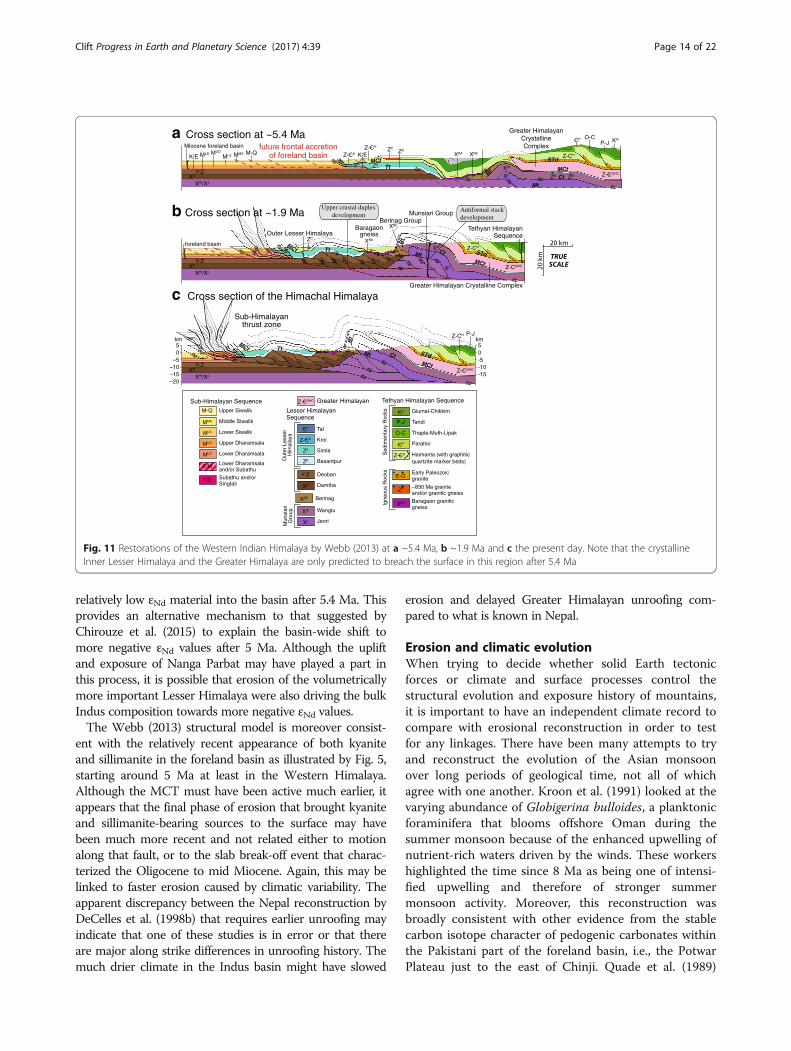
relatively low εNd material into the basin after 5.4 Ma. Thisprovides an alternative mechanism to that suggested byChirouze et al. (2015) to explain the basin-wide shift tomore negative εNd values after 5 Ma. Although the upliftand exposure of Nanga Parbat may have played a part inthis process, it is possible that erosion of the volumetricallymore important Lesser Himalaya were also driving the bulkIndus composition towards more negative εNd values.The Webb (2013) structural model is moreover consist-
ent with the relatively recent appearance of both kyaniteand sillimanite in the foreland basin as illustrated by Fig. 5,starting around 5 Ma at least in the Western Himalaya.Although the MCT must have been active much earlier, itappears that the final phase of erosion that brought kyaniteand sillimanite-bearing sources to the surface may havebeen much more recent and not related either to motionalong that fault, or to the slab break-off event that charac-terized the Oligocene to mid Miocene. Again, this may belinked to faster erosion caused by climatic variability. Theapparent discrepancy between the Nepal reconstruction byDeCelles et al. (1998b) that requires earlier unroofing mayindicate that one of these studies is in error or that thereare major along strike differences in unroofing history. Themuch drier climate in the Indus basin might have slowed
erosion and delayed Greater Himalayan unroofing com-pared to what is known in Nepal.
Erosion and climatic evolutionWhen trying to decide whether solid Earth tectonicforces or climate and surface processes control thestructural evolution and exposure history of mountains,it is important to have an independent climate record tocompare with erosional reconstruction in order to testfor any linkages. There have been many attempts to tryand reconstruct the evolution of the Asian monsoonover long periods of geological time, not all of whichagree with one another. Kroon et al. (1991) looked at thevarying abundance of Globigerina bulloides, a planktonicforaminifera that blooms offshore Oman during thesummer monsoon because of the enhanced upwelling ofnutrient-rich waters driven by the winds. These workershighlighted the time since 8 Ma as being one of intensi-fied upwelling and therefore of stronger summermonsoon activity. Moreover, this reconstruction wasbroadly consistent with other evidence from the stablecarbon isotope character of pedogenic carbonates withinthe Pakistani part of the foreland basin, i.e., the PotwarPlateau just to the east of Chinji. Quade et al. (1989)
km50
–5–10–15–20
km50-5-10-15
c Cross section of the Himachal Himalaya
b Cross section at ~1.9 Ma
a Cross section at ~5.4 Ma
M-QMMSMLS
XBE
ZCXBA
XW
XJ
ZS
ZB
XBEZC
XBA
XW
XJ
P-JO-C KG
ZS ZB
MUD
K/E MLD
Y-ZXD
XW/XJ
Y-ZXD
XW/XJ
Y-ZXD
XW/XJ
}
Miocene foreland basin
}foreland basin
K/EZ-CK
CP
Z-CH
Z-CGHC
future frontal accretionof foreland basin
}
Outer Lesser HimalayaBaragaon
gneiss
Berinag Group
Z-CGHC{Munsiari Group
Greater HimalayanCrystallineComplex
Tethyan HimalayanSequence
{Z-CH
Greater Himalayan Crystalline Complex
Z-CGHC
Z-CH P-J
Z-CH
Sub-Himalayanthrust zone
Upper crustal duplexdevelopment
Antiformal stackdevelopment
MCt
STd
CtMt
MCtTt
Bt
STdCtMt
MCt Tt
Bt
STdCtMt
MCt TtBt
MCt
MCt
Sub-Himalayan SequenceM-Q Upper Siwalik
MLS Lower Siwalik
MMS Middle Siwalik
MUD Upper Dharamsala
MLD Lower Dharamsala
K/E Subathu and/orSingtali
E/M Lower Dharamsalaand/or Subathu
Lesser Himalayan Sequence
Out
er L
esse
r H
imal
aya
Berinag
Mun
siar
iG
roup
XBE
XW
XJ
CT Tal
Z-CK Krol
ZS Simla
ZB Basantpur
Y-Z Deoban
XD Damtha
Wangtu
Jeori
Tethyan Himalayan Sequence
Sed
imen
tary
Roc
ksIg
neou
s R
ocks
KG
P-J
O-C
CP
XBA
Giumal-Chikkim
Tandi
Thaple-Muth-Lipak
Parahio
Haimanta (with graphiticquartzite marker beds)
Early Paleozoic granite
~830 Ma granite and/or granitic gneiss
Baragaon graniticgneiss
Z-CH
C-O
Z-CGHC Greater Himalayan
ZC
Fig. 11 Restorations of the Western Indian Himalaya by Webb (2013) at a ~5.4 Ma, b ~1.9 Ma and c the present day. Note that the crystallineInner Lesser Himalaya and the Greater Himalaya are only predicted to breach the surface in this region after 5.4 Ma
Clift Progress in Earth and Planetary Science (2017) 4:39 Page 14 of 22

showed a shift to more isotopically heavy carbonisotopes (δ13C) after ~ 7 Ma. This implied a shift fromvegetation dominated by C3 plant types, (i.e., mostlytrees) to more C4 domination (i.e., largely grassland).Although Quade et al. (1989) initially interpreted this toindicate a strengthening of the monsoon at that time,this was later changed to indicate a drying of the climatein the Indus floodplain after 7 Ma (Quade and Cerling1995). The same general trend is also seen in NW India,where the first significant development of C4 plants wasdated at 7 Ma and with dominant C4 growth after 5 Ma
(Singh et al. 2011). The scatter to lower δ13C values inNW India compared to Pakistan after 5 Ma may reflectthe moderately wetter conditions seen going east alongthe Himalayan front and which favor C3 flora (Fig. 12b).Oxygen isotopes have helped to confirm this interpret-ation of the vegetation changes. Dettman et al. (2001)provided oxygen isotope profiles through fossilfreshwater bivalve shells and mammal teeth that help toconstrain total rainfall and seasonality through the LateMiocene. These data showed the presence of a monsoonsince at least 10.7 Ma but also demonstrated that the
Fig. 12 Comparison of climate, erosion and exhumation proxies in the Himalaya. a Abundance of G. bulloides at ODP Site 730 on the Oman marginas a proxy for summer monsoon wind strength (Gupta et al. 2015). b Carbon isotope character of pedogenic carbonate in Pakistan as an indicator ofdominant vegetation in the Potwar Plateau of Pakistan (Quade et al. 1989), and NW India (Singh et al. 2011). c Global d18O as a proxy for seawatertemperatures and/or ice volume from Zachos et al. (2001). d Degree of chemical alteration of sediments on the Indus continental shelf at Indus MarineA-1 as measured by K/Al and CIA (Clift et al. 2008), e Rates of sediment supply to the Arabian Sea calculated from regional seismic (Clift 2006). f Exhumationrates of the Greater Himalaya tracked by bedrock Ar-Ar dating (Clift et al. 2008) and foreland basin sediment (Szulc et al. 2006)
Clift Progress in Earth and Planetary Science (2017) 4:39 Page 15 of 22

δ18O of wet-season rainfall was significantly more nega-tive before 7.5 Ma than after that time. Assuming thatthere was not a big change in source water compositionsat that time this shift in δ18O would imply increasingaridity after 7.5 Ma.Such interpretations beg the question as to why the
climate would dry at a time when summer monsoondriven upwelling in the Indian Ocean appeared to be in-tensifying. It should be remembered that the upwellingproxy does not record summer rain, but rather is linkedto the wind strength, which might potentially bedecoupled from one another in the context of long-termglobal cooling during the Late Miocene. This is despitethe fact that in the present day, coastal upwelling is largelymodulated by summer monsoon winds that are alsolinked to precipitation in SW Asia (Curry et al. 1992).Chemical weathering records from the Indus continentalmargin show long-term decrease in the degree ofalteration especially after around 10 Ma (Clift et al. 2008)that might indicate weaker monsoon over that timescale(Fig. 12d). Because humidity as well as temperature is akey control over the rates of chemical weathering (Westet al. 2005), Clift et al. (2008) argued that the decrease inthe degree of alteration seen in Indus River deltasediments reflects a drying of the climate after 10 Ma,broadly consistent with the carbon isotope data from theforeland basin. However, reconstructions from the SouthChina Sea now suggest that falling global temperaturesare the primary control on weathering rates, at least insouthern China (Wan et al. 2012; Clift et al. 2014).Although the age of drying/cooling inferred from
weathering records appears to precede the 8 Ma upwell-ing increase documented by Kroon et al. (1991), itshould be noted that more recent attempts to look atthe abundance of G. bulloides have resulted in a reevalu-ation of the record. Although upwelling strengthenedafter 8 Ma, it is noteworthy that the initial increasebegan around 13 Ma (Gupta et al. 2015) (Fig. 12a). Thisolder age for intensified wind strength is consistent withnew results from scientific ocean drilling in the Maldivesthat showed the development of a large sediment driftlink to prevailing monsoon winds, again starting ataround 12.9 Ma (Betzler et al. 2016).A new record for environmental evolution during this
critical transition around 8 Ma is presented here based onnew spectral color data scanned from ODP Site 730, thesame site analyzed for G. bulloides. This analysis is basedon the recognition that hematite and goethite are associ-ated with characteristic wavelengths in the spectrum ofthe sediment (Deaton and Balsam 1991; Balsam andDeaton 1991). The ratio of these two wavelengths can beused to estimate the relative intensity of these twominerals (Giosan et al. 2002). This is significant becausehematite is generally associated with hotter, drier, and
more seasonal conditions, whereas goethite is morecommonly recognized as a proxy for wetter, colderenvironments (Schwertmann 1971). Such an approach hasbeen used effectively before in the South China Sea(Zhang et al. 2007; Clift 2006) as a means for trackingcontinental humidity and thus monsoon strength.Figure 13 shows the hematite/goethite record from
10.7 to 8.5 Ma. Given the location of the core, this ispresumed to reflect environmental conditions in EasternArabia, which is the source of the clastic sedimentdeposited at this drill site. Although there is a periodbetween 9.9 and 9.5 Ma when hematite is relativelyscarce, the overall trend after 9.5 Ma is towards morehematite-rich, presumably drier, more seasonal condi-tions. Such a record is consistent with the other proxiesfor chemical weathering and sediment supply that favorsreducing precipitation and colder conditions, linked to aweakening summer monsoon into the Late Miocene.Exactly why the summer monsoon might be weakeningat that time is not entirely clear, but could be related tothe overall cooling of global climate at that time (Zachoset al. 2001), since times of cool dry conditions globallytend to correlate with times of weaker summermonsoons (Gupta et al. 2003; Clemens et al. 2010).Although there has been some debate in the past
concerning whether wetter climates might result in moreor less erosion (Burbank et al. 1993), studies of theQuaternary evolution of the Indus and Ganges deltashave shown that sediment supply increased during timesof strong monsoon (Clift and Giosan 2014; Goodbredand Kuehl 2000) when landsliding is also known to becommon in the source areas (Bookhagen et al. 2005).This particular form of mountain erosion is well recog-nized as being particularly efficient at generating largevolumes of sediment (Liu and Li 2015; Hovius and Stark2006). It is thus interesting to note that the supply ofsediment to the Indus delta and fan was estimated topeak during the middle Miocene, based on the interpret-ation of regional seismic reflection data coupled withsediment decompaction calculations (Fig. 12e) (Clift2006). That reconstruction suggested that sediment de-livery rates to the Arabian Sea dropped after the MiddleMiocene to reach a minimum in the Pliocene, beforerebounding to higher values during the Pleistocene.High rates of sediment delivery during the MiddleMiocene coincided with times of stronger chemicalweathering and suggest wet, more erosive climaticconditions at that time, at least in the WesternHimalaya. Falling rates of sediment delivery and reducederosion would then correlate with the drying climate inthe Late Miocene, consistent with the pedogenic carbon-ate stable isotope data.When considering the entire Himalayan range times
of strong precipitation and rapid erosion broadly
Clift Progress in Earth and Planetary Science (2017) 4:39 Page 16 of 22

correlate with episodes of fastest exhumation in the cen-tral and in Eastern Himalaya (Clift et al. 2008), but it isnoteworthy that the time of fastest exhumation is oldestin the West (Webb et al. 2017). It is possible that thisearlier phase of erosion relates to the initial phases ofmonsoon intensification whose timing is not welldefined but appears to strengthen around 23 Ma basedon data from the South China Sea (Clift et al. 2008). Un-fortunately, no matching record from that time yet existsin the Arabian Sea. Certainly, detrital thermochronology
from the foreland basin indicate that rapid erosion ofthe Western Greater Himalaya had begun during theOligocene (Fig. 9) and that this would be consistent withan earlier initiation of the South Asian monsoon, as wellas potentially with slab break-off (Webb et al. 2017).Given that the climate is drier in the Western Hima-
laya compared to the eastern and central ranges, slowererosion in that former area would result in older fissiontrack cooling ages being preserved in the bedrocksources. In contrast, faster erosion under the wetterclimate in the East has stripped away bedrock with theolder ages, which are only preserved in the GreaterHimalayan crystallines exposed in the west. Alterna-tively, if the slab breakoff mechanism proposed byWebb et al. (2017) is correct, then the difference infission track cooling ages may simply reflect thepropagation of the tear and uplift from west to eastduring the Miocene.
Climate-tectonic linkagesBecause the intensity of the South Asian monsoon hasbeen modeled to be largely dependent on the height ofthe Himalayan barrier (Boos and Kuang 2010) ratherthan on the height and extent of the Tibetan Plateau, aspreviously favored (Kutzbach et al. 1993; Molnar et al.1993), rebound of the Greater Himalaya caused by slabbreakoff would have raised the topographic barrier alongthe southern edge of the Tibetan Plateau and driven aprogressive increase in South Asian monsoon intensitystarting shortly after ~ 30 Ma. Evidence for tearing ofthe Indian slab comes from a variety of sources. Seismictomographic images of the mantle below India show aseismically fast region interpreted as detached Indianlithosphere (Replumaz et al. 2010). The distance betweenthe detached slab and the Indian plate now underthrust-ing the plateau reduces from west to east leadingReplumaz et al. (2010) to propose a lateral migration ofslab detachment from the western Himalaya to the cen-tral Himalaya. These authors further estimated this tear-ing to have occurred from 25 to 15 Ma. This seismicevidence is further supported by an east-to-west young-ing of alkaline and adakitic magmatic rocks that aredated at ~ 17–19 Ma at the western end of theHimalaya, 25–30 Ma in the East and ~ 15–8 Ma in theeast-central Himalaya has been interpreted as a productof lateral migration of slab detachment (Zhang et al.2014; Pan et al. 2012).In this scenario, the earlier onset of rapid erosion in
the Western Greater Himalaya would be linked not onlyto uplift of the range caused by slab breakoff, but by asynchronous intensification of summer monsoon rainsin that region driven by the increased height of thetopographic barrier (Webb et al. 2017). Evidence for theheight of the barrier is however rather thin. Hydrogen
8.0
8.5
9.0
9.5
10.0
10.5
11.0
0.1 0.2 0.3 0.4 0.5 0.6 0.7 0.8
Age
(M
a)
565/435Hematite/Goethite
More hematiteDrier climate
ODP Site 730
Fig. 13 Relative abundance of hematite versus goethite at ODP Site730 on the Oman margin implies steady drying after 9.5 Ma followinga wet period from 9.9 to 9.5 Ma. See Fig. 2 for location
Clift Progress in Earth and Planetary Science (2017) 4:39 Page 17 of 22

isotope data from minerals in shear zones aroundMount Everest indicating that the barrier in that locationwas > 5 km in the late Early Miocene (Gébelin et al.2013), but no similar dataset is known from thosemountains in the Indus catchment. Likewise, stableoxygen isotope data, which is sensitive to paleo-altitudes, from Miocene-Pliocene carbonate sedimentsin southern Nepal has been used to demonstratealtitudes of the southern Tibetan Plateau close to thepresent data before 11 Ma (Garzione et al. 2000). Similardata would argue for altitudes > 4 km in the centralTibetan Plateau as long ago as 35 Ma (Rowley andCurrie 2006). Not only do these data not constrainelevations in the western Himalaya but also they largelyrelate to the plateau and not the Himalayan barrier.Unfortunately, a sedimentary record of environmental
conditions and erosion during the Oligocene is mostlynot present in the Himalayan foreland basin because ofthe long-duration unconformity that separates theSubathu Formation from the Dagshai Formation(Najman 2006). Although it has been suggested that thisgap reflects a forebulge unconformity (DeCelles et al.1998a), more recently, it has been suggested that thishiatus is instead the product of rebound of the forelandbasin caused by faster erosion in the mountains, whichreduced the size of the orogenic load, thus allowing theforeland basin to partially invert during the EarlyMiocene (Clift and VanLaningham 2010). A similarerosion-driven inversion has been proposed from theHimalayas during the recent glacial episodes (Burbank1992). In this model the great foreland unconformity isanother reflection, together with the rapid exhumationof the Greater Himalaya, of an intensifying summermonsoon. However, if the slab breakoff model is valid,then this might also result in a flexural uplift of theforeland basin and the generation of a regional uncon-formity as the tear propagated from West into thecentral Himalaya. It is possible that both mechanismsmay be playing a role in the development of this breakin the record. Either way, the only sedimentary recordthat spans this critical period must be in the ArabianSea and this has yet to be recovered by scientific oceandrilling. Until this is remedied, it is unknown whenSouth Asian climate first became strongly monsoonaland if that is linked to faster erosion.Given the incompleteness of the record, is it possible
to say anything meaningful about the role of solid Earthtectonic processes compared to climatically modulatedsurface processes in controlling the erosion of theWestern Himalaya? Slowing of erosion after around17 Ma does not obviously correlate with any knownclimatic transition although it does shortly follow thewarmest conditions of the Mid-Miocene ClimaticOptimum (MMCO), which is expected to be a period of
strong tropical rainfall (You et al. 2009; Wan et al.2009). Instead, slowing exhumation after the MidMiocene may reflect slowing uplift related to earlier slabbreakoff, which triggered the initial phase of rapidexhumation seen to peak in the Western Himalaya at24–17 Ma (Figs. 8b and 12). The Ar-Ar mica data pointsto a slowing of exhumation after around 12 Ma (Fig. 8b),which correlates well to the strengthening wind condi-tions in the Arabian Sea (Betzler et al. 2016; Gupta et al.2015) (Fig. 12a). It is possible that the Late Mioceneslowing of erosion might be related to an initial weaken-ing of summer monsoon rain linked to global coolingthat occurs at and just before that time (Zachos et al.2001) (Fig. 12c).A more straightforward link to climatic conditions can
be seen in the slowing of exhumation rates after ~ 7 Ma.This is the time when the Ar-Ar data indicate reducedcooling rates and is when environmental conditions in theIndus floodplain became drier (Quade and Cerling 1995),with lower degrees of chemical weathering and reducedsediment flux to the ocean (Clift et al. 2008). What is lessclear is why reduced erosion rates and a weaker monsoonwould result in the exhumation of the Inner LesserHimalaya. This may be the simple culmination of a long-term process by which these rocks are being progressivelyunroofed through time. Although the monsoon is weakerin the Late Miocene than during the Middle Miocene, itwas still active and would have eventually exposed LesserHimalayan units as a result of the rock uplift driven by thestructural imbrication then occurring at depth. This viewimplies that exposure would have been largely driven bysolid Earth tectonic processes. Alternatively weakeningmonsoon might have resulted in a southward migration ofthe band of most intense rainfall (i.e., the IntertropicalConvergence Zone; ITCZ), which would have beenpushed further north onto the edge at the Tibetan Plateauduring times of strong summer monsoon. A review byArmstrong and Allen (2011) has proposed that the ITCZhas migrate southward during the Neogene. This modelwas largely based on the position of the smectite–illitetransition that marks the boundary between wind-blownclay derived from Asia and that from Central and SouthAmerica in the central Pacific Ocean (Lyle et al. 2002). Inthe western Pacific, a less dramatic migration southwardwas noted on the basis of the composition of manganesecrusts that are dependent on biologic and detrital fluxes(Kim et al. 2006). As the monsoon weakened, this band ofintense rainfall would have migrated south and becamepositioned over the region where the Inner LesserHimalaya are now exposed. Analog modeling of theformation of duplexes in mountain belts suggests thatthese are preferentially formed beneath areas wheresurface processes are driving intensified erosion(Malavieille 2010). Formation of a duplex in the Inner
Clift Progress in Earth and Planetary Science (2017) 4:39 Page 18 of 22

Lesser Himalaya after 5.4 Ma is indicative of intensifiederosion in this region, linked to migration of the climaticbands associated with the summer monsoon.The weakening of the summer monsoon during the Late
Miocene does however appear to be largely linked to globalcooling and not to changes in the height of the Himalayantopographic barrier, which was inferred to control monsoonstrength during the initial intensification during the laterOligocene to early Miocene (Webb et al. 2017). In thatmodel, exhumation of the Lesser Himalaya is largely drivenby changes in summer monsoon intensity and locationrather than solid Earth processes, which tended to be moresteady state. The Late Miocene to Pliocene exposure of theLesser Himalaya and duplex formation can be linked tomonsoon evolution driven by global climatic processes.
ConclusionsSedimentary records from the Himalayan foreland andArabian Sea show that changing environmental conditionslinked to summer monsoon intensity played an importantrole in controlling the structural evolution of the Himalaya.Greater Himalaya exhumation started earlier in the westernthan the central Himalaya, possibly linked to lithosphericslab breakoff that drove rock uplift and intensified thesummer monsoon by raising the topographic barrier of theHimalaya. This in turn further increased erosion rates thatpeaked in the Middle Miocene in the Indus Fan. A regionalunconformity in the foreland basin in the Oligocene toEarly Miocene reflects both uplift driven by slab breakoffand the strengthening monsoon that heightened erosionrates and reduced the orogenic load on the subductingplate. However, the presence of the unconformity meansthat deep sea records are required if we are to extend ourreconstruction beyond 20 Ma and so better correlateclimate and erosion with Greater Himalayan exhumation.Ar-Ar ages from detrital micas in the foreland basin
indicate that exhumation in the NW Himalaya slowedafter 17 Ma, apparently unrelated to monsoon variability.Initial strengthening of monsoonal winds is now dated tostart at 12.9 Ma but is not positively correlated with SouthAsian rainfall. Indeed, exhumation rates appear to slowafter 12 Ma implying a drier, less erosive climate. Strongerdrying of the climate is documented after ~ 10 Ma, asshown by carbon isotopes in pedogenic carbonates,increasing hematite/goethite values offshore Oman andfalling sediment supply rates in the Indus Fan, caused therainfall maxima to migrate south in the Himalaya.Focused erosion after that time allowed the Inner LesserHimalaya to duplex and become initially exposed after9 Ma. Wider exposure was delayed until ~ 6 Ma. Togetherwith unroofing of the Nanga Parbat Massif, this processdrove the average εNd value of the Indus Delta to morenegative values, removing the need for major drainagereorganization to account for this trend. Focused erosion
encouraged thrust duplex formation in the Inner LesserHimalaya, facilitating the exposure both of this unit andthe Greater Himalaya after ~ 6 Ma. This explains therelatively late appearance of kyanite and sillimanite insediments of the Middle and Upper Siwaliks respectively.Climate as well as solid Earth tectonic forces is seen to becrucial in the formation of the NW Himalaya.
AbbreviationsDSDP: Deep Sea Drilling Project; IODP: International Ocean DiscoveryProgram; ITCZ: Intertropical Convergence Zone; MCT: Main Central Thrust;MFT: Main Frontal Thrust; MMCO: Mid-Miocene Climatic Optimum;ODP: Ocean Drilling Program
AcknowledgementsPC gratefully acknowledges the travel grant from Japan Geoscience Union toattend the JpGU-AGU joint meeting 2017 held at Makuhari, Chiba, Japan, andthe Charles T. McCord Chair in Petroleum Geology for other research expenses.
FundingPC was supported by the Charles T. McCord Jr. Chair in Petroleum Geology.
Author’s informationPC is the Charles T. McCord Jr. Professor of Petroleum Geology and Dr. Henry V.Howe Distinguished Professor in Geology and Geophysics at Louisiana StateUniversity. He has worked on the geological evolution and erosion history of theWestern Himalaya for 20 years focusing on the Indus River system. PC works bothon and offshore, most recently as co-chief scientist on IODP Expedition 355 in theArabian Sea. Prior to 2012, he was Kilgour Professor of Geology at the Universityof Aberdeen, Scotland.
Competing interestsThe author declares that he has no competing interests.
Publisher’s NoteSpringer Nature remains neutral with regard to jurisdictional claims inpublished maps and institutional affiliations.
Received: 21 July 2017 Accepted: 15 November 2017
ReferencesAhmad T, Harris N, Bickle M, Chapman H, Bunbury J, Prince C (2000) Isotopic
constraints on the structural relationships between the Lesser Himalayanseries and the high Himalayan crystalline series, Garhwal Himalaya. Geol SocAm Bull 112(3):467–477
Ali JR, Aitchison JC (2005) Greater India. Earth Sci Rev 72:169–188Alizai A, Carter A, Clift PD, VanLaningham S, Williams JC, Kumar R (2011)
Sediment provenance, reworking and transport processes in the Indus Riverby U-Pb dating of detrital zircon grains. Glob Planet Chang 76:33–55. doi:10.1016/j.gloplacha.2010.11.008
Armstrong HA, Allen MB (2011) Shifts in the Intertropical Convergence Zone,Himalayan exhumation, and late Cenozoic climate. Geology 39(1):11–14. doi:10.1130/G31005.1
Balsam WL, Deaton BC (1991) Sediment dispersal in the Atlantic Ocean:evaluation by visible light spectra. Rev Aquat Sci 4:411–447
Bera MK, Sarkar A, Chakraborty PP, Loyal RS, Sanyal P (2008) Marine to continentaltransition in Himalayan foreland. Geol Soc Am Bull. doi:10.1130/B26265.1
Bernet M, Garver JI (2005) Fission-track analysis of detrital zircon. Rev MinGeochem 58:205–238
Bernet M, van der Beek P, Pik R, Huyghe P, Mugnier J-L, Labrin E, Szulc AG (2006)Miocene to recent exhumation of the central Himalaya determined fromcombined detrital zircon fission-track and U/Pb analysis of Siwalik sediments,western Nepal. Basin Res 18:393–412. doi:10.1111/j.1365-2117.2006.00303
Betzler C, Eberli GP, Kroon D, Wright JD, Swart PK, Nath BN, Alvarez-Zarikian CA,Alonso-García M, Bialik OM, Blättler CL, Guo JA, Haffen S, Horozai S, Inoue M,Jovane L, Lanci L, Laya JC, Mee ALH, Lüdmann T, Nakakuni M, Niino K,Petruny LM, Pratiwi SD, Reijmer JJG, Reolid J, Slagle AL, Sloss CR, Su X, Yao Z,
Clift Progress in Earth and Planetary Science (2017) 4:39 Page 19 of 22
Young JR (2016) The abrupt onset of the modern South Asian monsoonwinds. Sci Rep:29838. doi:10.1038/srep29838
Bignold SA, Treloar PJ, Petford N (2006) Changing sources of magma generationbeneath intra-oceanic island arcs: an insight from the juvenile Kohistan islandarc, Pakistan Himalaya. Chem Geol 233(1-2):46–74
Bookhagen B, Thiede RC, Strecker MR (2005) Late Quaternary intensifiedmonsoon phases control landscape evolution in the northwest Himalaya.Geology 33(2):149–152. https://doi.org/10.1130/G20982.1
Boos WR, Kuang Z (2010) Dominant control of the South Asian monsoon byorographic insulation versus plateau heating. Nature 463:218–222. doi:10.1038/nature08707
Burbank DW (1992) Causes of recent Himalayan uplift deduced from depositedpatterns in the Ganges basin. Nature 357:680–683
Burbank DW, Beck RA, Mulder T (1996) The Himalayan foreland basin. In: Yin A,Harrison TM (eds) The tectonics of Asia. Cambridge University Press, New York,pp 149–188
Burbank DW, Derry LA, France-Lanord C (1993) Reduced Himalayan sedimentproduction 8 Myr ago despite an intensified monsoon. Nature 364:48–50
Calvès G, Clift PD, Inam A (2008) Anomalous subsidence on the rifted volcanicmargin of Pakistan: no influence from Deccan plume. Earth Planet Sci Lett272:231–239
Calvès G, Huuse M, Clift PD, Brusset S (2015) Giant fossil mass wasting off the coastof West India: the Nataraja submarine slide. Earth Planet Sci Lett 432:265–272.doi:10.1016/j.epsl.2015.10.022
Catlos EJ, Harrison TM, Kohn MJ, Grove M, Ryerson FJ, Manning CE, Upreti BN(2001) Geochronologic and thermobarometric constraints on the evolutionof the main central thrust, central Nepal Himalaya. J Geophys Res 106(B8):16,177–116,204
Célérier J, Harrison TM, Beyssac O, Herman F, Dunlap WJ, Webb AAG (2009a) TheKumaun and Garwhal Lesser Himalaya, India: part 2. Thermal and deformationhistories. Geol Soc Am Bull 121(9-10):1281–1297. doi:10.1130/B26343.1
Célérier J, Harrison TM, Webb AAG, Yin A (2009b) The Kumaun and Garwhal lesserHimalaya, India: part 1. Structure and stratigraphy. Geol Soc Am Bull 121(9-10):1262–1280. doi:10.1130/B26344.1
Chirouze F, Huyghe P, Chauvel C, van der Beek P, Bernet M, Mugnier J-L (2015)Stable drainage pattern and variable exhumation in the Western Himalayasince the Middle Miocene. J Geol 123:1–20. doi:10.1086/679305
Clemens SC, Prell WL, Sun Y (2010) Orbital-scale timing and mechanisms drivingLate Pleistocene Indo-Asian summer monsoons: reinterpreting cavespeleothem ∂18O. Paleoceanography 25 (PA4207). doi:10.1029/2010PA001926
Clift P, Gaedicke C, Edwards R, Lee J II, Hildebrand P, Amjad S, White RS,Schlueter H-U (2002a) The stratigraphic evolution of the Indus fan andthe history of sedimentation in the Arabian Sea. Mar Geophys Res 23(3):223–245
Clift PD (2006) Controls on the erosion of Cenozoic Asia and the flux of clasticsediment to the ocean. Earth Planet Sci Lett 241(3-4):571–580
Clift PD, Blusztajn JS (2005) Reorganization of the western Himalayan river systemafter five million years ago. Nature 438(7070):1001–1003
Clift PD, Giosan L (2014) Sediment fluxes and buffering in the post-glacial IndusBasin. Basin Res 26:369–386. doi:10.1111/bre.12038
Clift PD, Hodges K, Heslop D, Hannigan R, Hoang LV, Calves G (2008) GreaterHimalayan exhumation triggered by Early Miocene monsoon intensification.Nat Geosci 1:875–880. doi:10.1038/ngeo351
Clift PD, Lee JI, Hildebrand P, Shimizu N, Layne GD, Blusztajn J, Blum JD, GarzantiE, Khan AA (2002b) Nd and Pb isotope variability in the Indus River system;implications for sediment provenance and crustal heterogeneity in thewestern Himalaya. Earth Planet Sci Lett 200(1-2):91–106. doi:10.1016/S0012-821X(02)00620-9
Clift PD, Shimizu N, Layne G, Gaedicke C, Schlüter HU, Clark MK, Amjad S (2001)Development of the Indus fan and its significance for the erosional history ofthe western Himalaya and Karakoram. Geol Soc Am Bull 113:1039–1051
Clift PD, VanLaningham S (2010) A climatic trigger for a major Oligo-Mioceneunconformity in the Himalayan foreland basin. Tectonics 29 (TC5014). doi:10.1029/2010TC002711
Clift PD, Wan S, Blusztajn J (2014) Reconstructing chemical weathering, physicalerosion and monsoon intensity since 25 Ma in the northern South ChinaSea: a review of competing proxies. Earth-Sci Rev 130:86–102. doi:10.1016/j.earscirev.2014.01.002
Copeland P, Harrison TM (1990) Episodic rapid uplift in the Himalaya revealed by40Ar/39Ar analysis of detrital K-feldspar and muscovite, Bengal fan. Geology18:354–357. doi:10.1130/0091-7613(1990)018
Critelli S, De Rosa R, Platt JP (1990) Sandstone detrital modes in the Makranaccretionary wedge, Southwest Pakistan; implications for tectonic setting andlong-distance turbidite transportation. Sediment Geol 68:241–260
Curry WB, Ostermann DR, Guptha MVS, Itekkot V (1992) Foraminiferal productionand monsoonal upwelling in the Arabian Sea; evidence from sediment traps.In: Summerhayes CP, Prell WL, Emeis KC (eds) Upwelling systems; evolutionsince the early Miocene, Special publication, vol 64. Geological Society,London, pp 93–106
Deaton BC, Balsam WL (1991) Visible spectroscopy—a rapid method fordetermining hematite and goethite concentration in geological materials. JSediment Petrol 61(4):628–632
DeCelles PG, Gehrels GE, Quade J, LaReau B, Spurlin M (2000) Tectonicimplications of U-Pb zircon ages of the Himalayan orogenic belt in Nepal.Science 288(5465):497–499. doi:10.1126/science.288.5465.497
DeCelles PG, Gehrels GE, Quade J, Ojha TP (1998a) Eocene-early Mioceneforeland basin development and the history of Himalayan thrusting, westernand central Nepal. Tectonics 17(5):741–765
DeCelles PG, Gehrels GE, Quade J, Ojha TP, Kapp PA, Upreti BN (1998b) Neogeneforeland basin deposits, erosional unroofing, and the kinematic history of theHimalayan fold-thrust belt, western Nepal. Geol Soc Am Bull 110(1):2–21
DeCelles PG, Giles KA (1996) Foreland basin systems. Basin Res 8(2):105–123DePaolo DJ, Wasserburg GJ (1976) Inferences about magma sources and mantle
structure from variations of 143Nd/144Nd. Geophys Res Lett 3(12):743–746Dettman DL, Kohn MJ, Quade J, Ryerson FJ, Ojha TP, Hamidullah S (2001)
Seasonal stable isotope evidence for a strong Asian monsoon throughoutthe past 10.7 m.y. Geology 29(1):31–34
Droz L, Bellaiche G (1991) Seismic facies and geologic evolution of the centralportion of the Indus fan. In: Weimer P, Link MH (eds) Seismic facies andsedimentary processes of submarine fans and turbidite systems. SpringerVerlag, Berlin, pp 383–402
Dunlap WJ, Wysoczanski R (2002) Thermal evidence for Early Cretaceousmetamorphism in the Shyok suture zone and age of the Khardung volcanicrocks, Ladakh, India. J Asian Earth Sci 20(5):481–490
Fraser JE, Searle MP, Parrish RR, Noble SR (2001) Chronology of deformation,metamorphism, and magmatism in the southern Karakoram Mountains. GeolSoc Am Bull 113(11):1443–1455
Garzanti E (1993) Sedimentary evolution and drowning of a passive margin shelf(Giumal Group; Zanskar Tethys Himalaya, India): palaeoenvironmentalchanges during final break-up of Gondwanaland. In: Treloar PJ, Searle MP(eds) Himalayan tectonics, Special publication, vol 74. Geological Society,London, pp 277–298. doi:10.1144/GSL.SP.1993.074.01.20
Garzanti E, Baud A, Mascle G (1987) Sedimentary record of the northward flightof India and its collision with Eurasia (Ladakh Himalaya, India). Geodin Acta1(4/5):297–312
Garzanti E, Vezzoli G, Ando S, Paparella P, Clift PD (2005) Petrology of Indus Riversands; a key to interpret erosion history of the western Himalayan syntaxis.Earth Planet Sci Lett 229(3-4):287–302. doi:10.1016/j.epsl.2004.11.008
Garzione CN, Dettman DL, Quade J, DeCelles PG, Butler RF (2000) High times onthe Tibetan Plateau; paleoelevation of the Thakkhola Graben, Nepal. Geology28(4):339–342
Gébelin A, Mulch A, Teyssier C, Jessup MJ, Law RD, Brunel M (2013) The Mioceneelevation of Mount Everest. Geology 41(7):799–802. doi:10.1130/G34331.1
Gehrels GE, Kapp P, DeCelles P, Pullen A, Blakely R, Weislgel A, Ding L, Guynn J,Marin A, McQuarrie N, Yin A (2011) Detrital zircon geochronology of pre-Tertiary strata in the Tibetan-Himalayan orogen. Tectonics 30 (TC5016). doi:10.1029/2011TC002868
Giosan L, Flood RD, Grutzner J, Mudie P (2002) Paleoceanographic signi¢cance ofsediment color on western North Atlantic drifts: II. Late Pliocene-Pleistocenesedimentation. Mar Geol 189:43–61
Goldstein SJ, Jacobsen SB (1988) Nd and Sr isotopic systematics of river watersuspended material; implications for crustal evolution. Earth Planet Sci Lett87(3):249–265
Goodbred SL, Kuehl SA (2000) Enormous Ganges-Brahmaputra sedimentdischarge during strengthened early Holocene monsoon. Geology 28(12):1083–1086
Gupta AK, Anderson DM, Overpeck JT (2003) Abrupt changes in the Asiansouthwest monsoon during the Holocene and their links to the NorthAtlantic Ocean. Nature 421:354–356
Gupta AK, Yuvaraja A, Prakasam M, Clemens SC, Velu A (2015) Evolution of theSouth Asian monsoon wind system since the late Middle Miocene. PalaeogeogrPalaeoclimatol Palaeoecol 438:160–167. doi:10.1016/j.palaeo.2015.08.006
Clift Progress in Earth and Planetary Science (2017) 4:39 Page 20 of 22

Harrison TM, Célérier J, Aikman A, Hermann J, Heizler M (2009) Diffusion of 40Arin muscovite. Geochim Cosmochim Acta 73:1039–1051
Hildebrand PR, Searle MP, Shakirullah, van Heijst HJ (2000) Geologicalevolution of the Hindu Kush, NW Frontier Pakistan; active margin tocontinent-continent collision zone. In: Khan MA, Treloar PJ, Searle MP,Jan MQ (eds) Tectonics of the Nanga Parbat syntaxis and the westernHimalaya, Special publication, vol 170. Geological Society, London, pp277–293
Hodges K (2003) Geochronology and thermochronology in orogenic systems. In:Rudnick R (ed) The crust. Elsevier-Science, Amsterdam, pp 263–292
Hodges KV, Silverberg DS (1988) Thermal evolution of the Greater Himalaya,Garhwal, India. Tectonics 7(3):583–600
Hovius N, Stark CP (2006) Landslide-driven erosion and topographic evolution ofactive mountain belts. In: Evans SG, Mugnozza GS, Strom A, Hermanns RL(eds) Landslides from massive rock slope failure. Springer Netherlands,Dordrecht, pp 573–590. doi:10.1007/978-1-4020-4037-5_30
Hurford AJ (1986) Cooling and uplift patterns in the Lepontine Alps, SouthCentral Switzerland and an age of vertical movement on the Isubric faultline. Contrib Mineral Petrol 92:413–427
Inam A, Clift PD, Giosan L, Tabrez AR, Tahir M, Rabbani MM, Danish M (2007) Thegeographic, geological and oceanographic setting of the Indus River. In:Gupta A (ed) Large rivers: geomorphology and management. Wiley,Chichester, pp 333–345
Jain AK, Lal N, Sulemani B, Awasthi AK, Singh S, Kumar R, Kumar D (2009)Detrital-zircon fission-track ages from the lower Cenozoic sediments, NWHimalayan foreland basin: clues for exhumation and denudation of theHimalaya during the India-Asia collision. Geol Soc Am Bull 121(3/4):519–535.doi:10.1130/B26304.1
Johnson NM, Stix J, Tauxe L, Cerveny PF, Tahirkheli RAK (1985) Palaeomagneticchronology, fluvial processes and tectonic implications of the Siwalikdeposits near Chinji Village, Pakistan. J Geol 93:27–40
Khan MA, Stern RJ, Gribble RF, Windley BF (1997) Geochemical and isotopicconstraints on subduction polarity, magma sources, and palaeogeography ofthe Kohistan intra-oceanic arc, northern Pakistan Himalaya. J Geol Soc Lond154:935–946
Kim J, Hyeong K, Jung HS, Moon JW, Kim KH, Lee I (2006) Southward shift of theIntertropical Convergence Zone in the western Pacific during the late Tertiary:evidence from ferromanganese crusts on seamounts west of the MarshallIslands. Paleoceanography 21 (Pa4218). doi: doi:10.1029/2006pa001291
Kolla V, Coumes F (1987) Morphology, internal structure, seismic stratigraphy, andsedimentation of Indus fan. AAPG Bull 71:650–677
Kroon D, Steens T, Troelstra SR (1991) Onset of monsoonal related upwelling inthe western Arabian Sea as revealed by planktonic foraminifers. In: Prell W,Niitsuma N (eds) Proceedings of the ocean drilling program, scientific results,vol 117. Ocean Drilling Program, College Station, pp 257–263
Kutzbach JE, Prell WL, Ruddiman WF (1993) Sensitivity of Eurasian climate to surfaceuplift of the Tibetan Plateau. J Geol 101:177–190
Lee JI, Clift PD, Layne G, Blum J, Khan AA (2003) Sediment flux in the modernIndus River traced by the trace element composition of detrital amphibolegrains. Sediment Geol 160:243–257. doi:10.1016/S0037-0738(02)00378-0
Licht A, van Cappelle M, Abels HA, Ladant J-B, Trabucho-Alexandre J, France-Lanord C, Donnadieu Y, Vandenberghe J, Rigaudier T, Lecuyer C, Terry D,Adriaens R, Boura A, Guo Z, Soe AN, Quade J, Dupont-Nivet G, Jaeger J-J(2014) Asian monsoons in a late Eocene greenhouse world. Nature 513:501–506. doi:10.1038/nature13704
Liu F, Li J (2015) Landslide erosion associated with the Wenchuan earthquake in theMinjiang River watershed: implication for landscape evolution of the LongmenShan, eastern Tibetan Plateau. Nat Hazards 76(3):1911–1926. https://doi.org/10.1007/s11069-014-1575-8
Lyle MW, Wilson PA, Janecek TR, Shipboard party (2002) Leg 199 summary. In: LyleMW, Wilson P, Janecek TR (eds) Proceedings of the ocean drilling program,initial reports, vol 199. Ocean Drilling Program, College Station, pp 1–89
Malavieille J (2010) Impact of erosion, sedimentation, and structural heritage onthe structure and kinematics of orogenic wedges: analog models and casestudies. GSA Today 20(1). doi:10.1130/GSATG48A.1
Meigs AJ, Burbank DW, Beck RA (1995) Middle-late Miocene (>10 Ma) formationof the main boundary thrust in the western Himalaya. Geology 23(5):423–426
Miles PR, Roest WR (1993) Earliest seafloor spreading magnetic anomalies in the northArabian Sea and the ocean-continent transition. Geophys J Int 115:1025–1031
Molnar P, England P, Martinod J (1993) Mantle dynamics, uplift of the TibetanPlateau, and the Indian monsoon. Rev Geophys 31(4):357–396
Montgomery DR, Stolar DB (2006) Reconsidering Himalayan river anticlines.Geomorphology 82:4–15. doi:10.1016/j.geomorph.2005.08.021
Naini BR, Kolla V (1982) Acoustic character and thickness of sediments of theIndus fan and the continental margin of western India. Mar Geol 47:181–195
Najman Y (2006) The detrital record of orogenesis: a review of approaches andtechniques used in the Himalayan sedimentary basins. Earth-Sci Rev 74(1-2):1–72
Najman Y, Bickle M, Garzanti E, Pringle M, Barfod D, Brozovic N, Burbank D, AndoS (2009) Reconstructing the exhumation history of the Lesser Himalaya, NWIndia, from a multitechnique provenance study of the foreland basin SiwalikGroup. Tectonics 28 (TC5018). doi:10.1029/2009TC002506
Najman Y, Garzanti E (2000) Reconstructing early Himalayan tectonic evolutionand paleogeography from Tertiary foreland basin sedimentary rocks,northern India. Geol Soc Am Bull 112(3):435–449
Najman Y, Pringle M, Godin L, Oliver G (2001) Dating of the oldest continentalsediments from the Himalayan foreland basin. Nature (London) 410(6825):194–197
Najman YMR, Pringle MS, Johnson MRW, Robertson AHF, Wijbrans JR (1997) Laser40Ar/39Ar dating of single detrital muscovite grains from early foreland-basinsedimentary deposits in India; implications for early Himalayan evolution.Geology 25(6):535–538
Ojha TP, Butler RF, Quade J, DeCelles PG, Richards D, Upreti BN (2000) Magneticpolarity stratigraphy of the Neogene Siwalik Group at Khutia Khola, far westernNepal. Geol Soc Am Bull 112(3):424–434
Pan F-B, Zhang H-F, Harris N, W-C X, Guo L (2012) Oligocene magmatism in theeastern margin of the east Himalayan syntaxis and its implication for theIndia-Asia post-collisional process. Lithos 154:181–192. doi:10.1016/j.lithos.2012.07.004
Pandey DK, Clift PD, Kulhanek DK, Expedition 355 Scientists (2015) Arabian SeaMonsoon. Int Ocean Disc Prog Prelim Rpt 355. doi:10.2204/iodp.pr.355.2015
Phillips RJ, Parrish RR, Searle MP (2004) Age constraints on ductile deformationand long-term slip rates along the Karakoram fault zone, Ladakh. Earth PlanetSci Lett 226:305–319
Prell WL, Murray DW, Clemens SC, Anderson DM (1992) Evolution and variabilityof the Indian Ocean summer monsoon: evidence from the western ArabianSea drilling program. In: Duncan RA, Rea DK, Kidd RB, von Rad U, Weissel JK(eds) Synthesis of results from scientific drilling in the Indian Ocean,Geophysical monograph, vol 70. American Geophysical Union, Washington,DC, pp 447–469
Quade J, Cerling TE (1995) Expansion of C4 grasses in the late Miocene ofnorthern Pakistan: evidence from stable isotopes in Paleosols. PalaeogeogrPalaeoclimatol Palaeoecol 115(1-4):91–116
Quade J, Cerling TE, Bowman JR (1989) Development of Asian monsoon revealedby marked ecological shift during the latest Miocene in northern Pakistan.Nature 342(6246):163–166
Raiverman V, Kunte SV, Mukherjea A (1983) Basin geometry, Cenozoicsedimentation and hydrocarbon prospects in northwestern Himalaya andIndo–Gangetic plains. Petrol Asia J 6:67–92
Raiverman V, Raman KS (1971) Facies relations in the Subathu sediments, SimlaHills, N.W. Himalaya, India. Geol Mag 108:329–341
Rao AR (1993) Magnetic-polarity stratigraphy of upper Siwalik of north-westernHimalayan foothills. Curr Sci 64(11/12):863–873
Replumaz A, Negredo AM, Villaseñor A, Guillot S (2010) Indian continentalsubduction and slab break-off during tertiary collision. Terra Nova 22:290–296. doi:10.1111/j.1365-3121.2010.00945.x
Robertson AHF, Collins AS (2002) Shyok suture zone, N Pakistan; late Mesozoic-Tertiary evolution of a critical suture separating the oceanic Ladakh Arc fromthe Asian continental margin. J Asian Earth Sci 20(3):309–351
Robertson AHF, Degnan PJ (1994) The Dras arc complex: lithofacies and reconstructionof a late cretaceous oceanic volcanic arc in the Indus suture zone, Ladakh Himlaya.Sediment Geol 92:117–145
Roddaz M, Said A, Guillot S, Antoine PO, Montel JM, Martin F, Darrozes J (2011)Provenance of Cenozoic sedimentary rocks from the Sulaiman fold and thrustbelt, Pakistan: implications for the palaeogeography of the Indus drainagesystem. J Geol Soc Lond 168:499–516. doi:10.1144/0016-76492010-100
Rowley DB, Currie BS (2006) Palaeo-altimetry of the late Eocene to Miocene Lunpolabasin, central Tibet. Nature 439:677–681
Schärer U, Copeland P, Harrison TM, Searle MP (1990) Age, cooling history, and originof post-collisional leucogranites in the Karakoram Batholith; a multi-system isotopestudy. J Geol 98(2):233–251
Schwertmann U (1971) Transformation of hematite to goethite in soils. Nature232:624–625
Clift Progress in Earth and Planetary Science (2017) 4:39 Page 21 of 22
Searle MP (1996) Cooling history, erosion, exhumation and kinematics of theHimalaya-Karakoram-Tibet orogenic belt. In: Yin A, Harrison TM (eds) Thetectonic evolution of Asia. Cambridge University Press, Cambridge, pp 110–137
Searle MP, Fryer BJ (1986) Garnet, tourmaline and muscovite-bearingleucogranites, gneisses and migmatites of the higher Himalayas fromZanskar, Kulu, Lahoul and Kashmir. In: Coward MP, Ries AC (eds), SpecialPublications, vol 19. Geological Society, London, pp 185-201 doi:10.1144/GSL.SP.1986.019.01.10
Searle MP, Law RD, Jessup M, Simpson RL (2006) Crustal structure andevolution of the greater Himalaya in Nepal – South Tibet: implicationsfor channel flow and ductile extrusion of the middle crust. In: Law RD,Searle MP, Godin L (eds) Channel flow, ductile extrusion andexhumation in continental collision zones, Special publication, vol 268.Geological Society, London, pp 355–378
Searle MP, Rex AJ, Tirrul R, Rex DC, Barnicoat A, Windley BF (1989) Metamorphic,magmatic and tectonic evolution of the central Karakoram in the Biafo-Baltoro-Hushe regions of north Pakistan. Geol Soc Am Spec Pap 232:47–73
Shuaib SM, Tariq Shuaib SM (1999) Geology and oil/Gass presence in theoffshore Indus Basin of Pakistan. In: Meadows A, Meadows PS (eds) The IndusRiver: biodiversity, resources, humankind. Oxford University Press, Karachi, pp249–265
Simpson G (2004) Role of river incision in enhancing deformation. Geology 32(4):341–345. https://doi.org/10.1130/G20190.2
Singh S, Parkash B, Awasthi AK, Kumar S (2011) Late Miocene record ofpalaeovegetation from Siwalik palaeosols of the Ramnagar sub-basin, India.Curr Sci 100(2):213–222
Sinha RN (1970) Heavy mineral investigation of the Siwaliks of Mohand, districtSaharanpur, Uttar Pradesh. J Geol Soc India 11:163–177
Stephenson BJ, Searle MP, Waters DJ, Rex DC (2001) Structure of the main centralthrust zone and extrusion of the high Himalayan deep crustal wedge,Kishtwar-Zanskar Himalaya. J Geol Soc Lond 158(4):637–652
Szulc AG, Najman Y, Sinclair HD, Pringle M, Bickle M, Chapman H, Garzanti E,Ando S, Huyghe P, Mugnier J-L, Ojha T, DeCelles PG (2006) Tectonicevolution of the Himalaya constrained by detrital 40Ar/39Ar, Sm/Nd andpetrographic data from the Siwalik foreland basin succession, SW Nepal.Basin Res 18(4):375–391
Tagami T, Ito H, Nishimura S (1990) Thermal annealing characteristics ofspontaneous fi ssion tracks in zircon. Chem Geol 80:159–169
Tauxe L, Opdyke ND (1982) A time framework based on magnetostratigraphy ofthe Siwalik sediments of the Khaur arae, northern Pakistan. PalaeogeogrPalaeoclimatol Palaeoecol 37:43–61
Treloar PJ, Rex DC, Guise PG, Wheeler J, Hurford AJ, Carter A (2000)Geochronological constraints on the evolution of the Nanga Parbat syntaxis,Pakistan Himalaya. In: Khan MA, Treloar PJ, Searle MP, Jan MQ (eds) Tectonicsof the Nanga Parbat syntaxis and the western Himalaya, Geological societyspecial publication, vol 170. Geological Society, London, pp 137–162
Vermeesch P (2012) On the visualisation of detrital age distributions. Chem Geol312–313:190–194. doi:10.1016/j.chemgeo.2012.04.021
Vidal P, Cocherie A, Le Fort P (1982) Geochemical investigations of the origin ofthe Manaslu leucogranite (Himalaya, Nepal). Geochim Cosmochim Acta 46:2279–2292
Walker J, Martin MW, Bowring SA, Searle M, Waters DJ, Hodges K (1999)Metamorphism, melting, and extension: age constraints from the highHimalayan slab of southeast Zanskar and northwest Lahaul. J Geol 107:473–495
Wan S, Clift PD, Li A, Yu Z, Li T, Hu D (2012) Tectonic and climatic controls onlong-term silicate weathering in Asia since 5 Ma. Geophys Res Lett39(L15611). doi:10.1029/2012GL052377
Wan S, Kürschner WM, Clift PD, Li A, Li T (2009) Extreme weathering/erosionduring the Miocene climatic optimum: evidence from sediment record inthe South China Sea. Geophys Res Lett 36(L19706). doi:10.1029/2009GL040279
Webb AAG (2013) Preliminary palinspastic reconstruction of Cenozoicdeformation across the Himachal Himalaya (northwestern India). Geosphere9:572–587
Webb AAG, Guo H, Clift PD, Husson L, Müller T, Costantino D, Yin A, Xu Z, Cao H,Wang Q (2017) The Himalaya in 3D: slab dynamics controlled mountain buildingand monsoon intensification. Lithosphere. doi:10.1130/L636.1
West AJ, Galy A, Bickle MJ (2005) Tectonic and climatic controls on silicateweathering. Earth Planet Sci Lett 235:211–228. doi:10.1016/j.epsl.2005.03.020
Whipple KX (2009) The influence of climate on the tectonic evolution ofmountain belts. Nat Geosci 2:1–8. doi:10.1038/ngeo413
White NM, Pringle M, Garzanti E, Bickle M, Najman Y, Chapman H, Friend P (2002)Constraints on the exhumation and erosion of the high Himalayan slab, NWIndia, from foreland basin deposits. Earth Planet Sci Lett 195:29–44
Whitmarsh RB, Weser OE, Ross DA, Shipboard Scientific Party (1974) Site 221.Initial reports of the Deep Sea drilling project, vol 23, pp 167–210
Whittington A, Foster G, Harris N, Vance D, Ayres M (1999) Lithostratigraphic correlationsin the western Himalaya—an isotopic approach. Geology 27(7):585–588
Willett SD (1999) Orogeny and orography: the effects of erosion on the structureof mountain belts. J Geophys Res 104:28957–28981
You Y, Huber M, Müller RD, Poulsen CJ, Ribbe J (2009) Simulation of the MiddleMiocene climate optimum. Geophys Res Lett 36(4). doi:10.1029/2008GL036571
Zachos J, Pagani M, Sloan L, Thomas E, Billups K (2001) Trends, rythms andabberations in global climate 65 Ma to present. Science 292:686–693
Zeitler PK, Sutter JF, Williams IS, Zartman RE, Tahirkheli RAK (1989) Geochronologyand temperature history of the Nanga Parbat-Haramosh Massif, Pakistan. In:Malinconico LL, Lillie RJ (eds) Tectonics of the western Himalayas, Special Paper,vol 232. Geological Society of America, Boulder, pp 1–22
Zhang L-Y, Ducea MN, Ding L, Pullen A, Kapp P, Hoffman D (2014) SouthernTibetan Oligocene-Miocene adakites: a record of Indian slab tearing. Lithos210-211:209–223. doi:10.1016/j.lithos.2014.09.029
Zhang Q, Willems H, Ding L, Gräfe K-U, Appel E (2012) Initial India-Asiacontinental collision and Foreland Basin evolution in the Tethyan Himalayaof Tibet: evidence from Stratigraphy and Paleontology. J Geol 120(2):175–189
Zhang YG, Jia J, Balsam WL, Liu L, Chen J (2007) High resolution hematite andgoethite records from ODP 1143, South China Sea: co-evolution ofmonsoonal precipitation and El Niño over the past 600,000 years. EarthPlanet Sci Lett 264(1-2):136–150
Zhuang G, Najman Y, Guillot S, Roddaz M, Antoine P-O, Métaise G, Carter A,Marivaux L, Solangig SH (2015) Constraints on the collision and the pre-collision tectonic configuration between India and Asia from detritalgeochronology, thermochronology, and geochemistry studies in the lowerIndus basin, Pakistan. Earth Planet Sci Lett 432:363–373. doi:10.1016/j.epsl.2015.10.026
Clift Progress in Earth and Planetary Science (2017) 4:39 Page 22 of 22