central concord redevelopment · central concord redvelopment plan city of concord central concord...
TRANSCRIPT

CENTRAL CONCORD REDVELOPMENT PLAN
City of Concord
CENTRAL CONCORD REDEVELOPMENT PLAN
Adopted by City Council Ordinance No. 991, dated November 25, 1974
As amended by City Council Ordinance No. 1060, dated November 22, 1976
As amended by City Council Ordinance No. 1156, dated July 9, 1979
As amended by City Council Ordinance No. 83-11, dated May 2, 1983
As amended by City Council Ordinance No. 85-31, dated June 24, 1985
As amended by City Council Ordinance No. 88-24, dated September 13, 1988
As amended by City Council Ordinance No. 94-16, dated November 22, 1994 andCity Council Ordinance No. 94-19, dated November 22, 1994
As amended by City Council Ordinance No. 99-16, dated December 7, 1999
As amended by City Council Ordinance No. 01-08, dated June 5, 2001
As amended by City Council Ordinance No. 02-10, dated November 26, 2002
As amended by City Council Ordinance No. 03-08, dated January 6, 2004
As amended by City Council Ordinance No. 05-03, dated May 3, 2005
As amended by City Council Ordinance No. 06-09, dated September 5, 2006
As amended by City Council Ordinance No. 06-12, dated October 24, 2006

CENTRAL CONCORD REDVELOPMENT PLAN
i
Table of Contents
I. Introduction . . . . . . . . . . . . . . . . . . . . . . . . . . . . . . . . . . . . . . . . . . . .1
II. General Definitions . . . . . . . . . . . . . . . . . . . . . . . . . . . . . . . . . . . . . . .2
III. Project Area Boundaries . . . . . . . . . . . . . . . . . . . . . . . . . . . . . . . . . . . 4
IV. Redevelopment Objectives . . . . . . . . . . . . . . . . . . . . . . . . . . . . . . . . . 31
V. Redevelopment Techniques to Achieve Plan Objectives . . . . . . . . . . . . . . 37
A. Participation by Owners and Business Tenants . . . . . . . . . . . . . . . . 37
1. Opportunities for Owners and Business Tenants . . . . . . . . . . . .372. Rules for Participation Opportunities, Priorities, and Preferences .39
3. Participation Agreements . . . . . . . . . . . . . . . . . . . . . . . . . . . 39
B. Property Acquisition . . . . . . . . . . . . . . . . . . . . . . . . . . . . . . . . . 39
1. Acquisition of Real Property . . . . . . . . . . . . . . . . . . . . . . . . 392. Acquisition of Personal Property . . . . . . . . . . . . . . . . . . . . . . 41
C. Cooperation with Public Bodies . . . . . . . . . . . . . . . . . . . . . . . . . . 41
D. Property Management . . . . . . . . . . . . . . . . . . . . . . . . . . . . . . . . 41
E. Relocation of Persons Displaced . . . . . . . . . . . . . . . . . . . . . . . . . 41
1. Assistance in Finding Other Locations . . . . . . . . . . . . . . . . . . 412. Relocation Payments . . . . . . . . . . . . . . . . . . . . . . . . . . . . . 42
F. Demolition, Clearance, Public Improvements, Building and SitePreparation . . . . . . . . . . . . . . . . . . . . . . . . . . . . . . . . . . . . . . . 42
1. Demolition and Clearance . . . . . . . . . . . . . . . . . . . . . . . . . . 422. Public Improvements . . . . . . . . . . . . . . . . . . . . . . . . . . . . . 42
3. Preparation of Building and Development Sites . . . . . . . . . . . . 444. Landmark Preservation . . . . . . . . . . . . . . . . . . . . . . . . . . . . 44

CENTRAL CONCORD REDVELOPMENT PLAN
ii
Table of Contents (cont.)
G. Rehabilitation and Moving of Structures by the Agency . . . . . . . . . . 44
1. Rehabilitation . . . . . . . . . . . . . . . . . . . . . . . . . . . . . . . . . . 44
2. Moving Structures . . . . . . . . . . . . . . . . . . . . . . . . . . . . . . . 44
H. Property Disposition and Development . . . . . . . . . . . . . . . . . . . . . 44
1. Real Property Disposition and Development . . . . . . . . . . . . . . 452. Personal Property Disposition . . . . . . . . . . . . . . . . . . . . . . . . 47
I. Prevention of Discrimination . . . . . . . . . . . . . . . . . . . . . . . . . . . . 47
1. Redevelopment . . . . . . . . . . . . . . . . . . . . . . . . . . . . . . . . . 47
2. Contracts . . . . . . . . . . . . . . . . . . . . . . . . . . . . . . . . . . . . . 48
3. Duration . . . . . . . . . . . . . . . . . . . . . . . . . . . . . . . . . . . . . . 48
VI. Permitted Land Uses . . . . . . . . . . . . . . . . . . . . . . . . . . . . . . . . . . . . . 49
A. Land Use Map . . . . . . . . . . . . . . . . . . . . . . . . . . . . . . . . . . . . 49
B. Streets and Rights-of-way . . . . . . . . . . . . . . . . . . . . . . . . . . . . . . 49
C. General Controls and Limitations . . . . . . . . . . . . . . . . . . . . . . . . . 49
1. New Construction . . . . . . . . . . . . . . . . . . . . . . . . . . . . . . . 492. Existing Non-Conforming Uses . . . . . . . . . . . . . . . . . . . . . . 49
3. Rehabilitation . . . . . . . . . . . . . . . . . . . . . . . . . . . . . . . . . . 50
4. Open Spaces and Landscaping . . . . . . . . . . . . . . . . . . . . . . . 50
5. Signs . . . . . . . . . . . . . . . . . . . . . . . . . . . . . . . . . . . . . . . . 506. Utilities . . . . . . . . . . . . . . . . . . . . . . . . . . . . . . . . . . . . . . 507. Incompatible Uses . . . . . . . . . . . . . . . . . . . . . . . . . . . . . . . 50
8. Nondiscrimination and Nonsegregation . . . . . . . . . . . . . . . . . 51
9. Resubdivision of Parcels . . . . . . . . . . . . . . . . . . . . . . . . . . . 51
10. Variations . . . . . . . . . . . . . . . . . . . . . . . . . . . . . . . . . . . . . 51

CENTRAL CONCORD REDVELOPMENT PLAN
iii
Table of Contents (cont.)
D. Standards for Development . . . . . . . . . . . . . . . . . . . . . . . . . . . . . 51
E. Building Permits . . . . . . . . . . . . . . . . . . . . . . . . . . . . . . . . . . . . 52
1. Review of Applications . . . . . . . . . . . . . . . . . . . . . . . . . . . . 52
2. Appeal . . . . . . . . . . . . . . . . . . . . . . . . . . . . . . . . . . . . . . . 52
VII. Neighborhood Impact Statement . . . . . . . . . . . . . . . . . . . . . . . . . . . . . 53
VIII. Methods for Financing the Project . . . . . . . . . . . . . . . . . . . . . . . . . . . . 56
A. General Description of the Proposed Financing Method . . . . . . . . . . 56
B. Tax Increments . . . . . . . . . . . . . . . . . . . . . . . . . . . . . . . . . . . . . 56
1. Limit on Tax Dollars Receivable . . . . . . . . . . . . . . . . . . . . . . 572. Time Limit on Tax Increment Receipt and Repayment of
Indebtedness . . . . . . . . . . . . . . . . . . . . . . . . . . . . . . . . . . . 573. Limit on Outstanding Bond Indebtedness . . . . . . . . . . . . . . . . 58
C. Other Loans and Grants . . . . . . . . . . . . . . . . . . . . . . . . . . . . . . . 59
IX. Actions by the City . . . . . . . . . . . . . . . . . . . . . . . . . . . . . . . . . . . . . . 60
X. Enforcement . . . . . . . . . . . . . . . . . . . . . . . . . . . . . . . . . . . . . . . . . . 61
XI. Duration of this Plan . . . . . . . . . . . . . . . . . . . . . . . . . . . . . . . . . . . . . 62
A. Time Limit on Redevelopment Activities . . . . . . . . . . . . . . . . . . . . 62
XII. Procedure for Amendment . . . . . . . . . . . . . . . . . . . . . . . . . . . . . . . . . 63

CENTRAL CONCORD REDVELOPMENT PLAN
1
I. INTRODUCTION
The Central Concord Redevelopment Plan consists of text, the Boundary Map(Exhibit A, Revised 2006), and the Land Use Map (Exhibit B, Revised 2006).
This Plan has been prepared by the Redevelopment Agency of the City of Concord,
Concord, California, pursuant to The Constitution of the State of California, the
Community Redevelopment Law of the State of California, and all applicable laws and
local ordinances.

CENTRAL CONCORD REDVELOPMENT PLAN
2
II. GENERAL DEFINITIONS
The following references will be used in this Plan unless the context otherwiserequires:
A. “Added Area” means the areas added to the Original Project Area byAmendment No. 13 to the Redevelopment Plan, as shown on pages 2 through 4of the Boundary Map (Exhibit A, Revised 2006), and as referred to anddescribed as Parcel V in subparagraph E of Section III of this Plan.
B. “Agency” means the Redevelopment Agency of the City of Concord, Concord,California.
C. “Boundary Map” means the map of the boundaries of the Central ConcordProject Area, as amended to include both the Original Project Area and theAdded Area, attached as Exhibit A, Revised 2006. All references in this Plan toExhibit A mean Exhibit A, Revised 2006.
D. “City” means the City of Concord, California.
E. “County” means the County of Contra Costa, California.
F. “General Plan” means the Concord General Plan.
G. “Land Use Map” means the map for the Central Concord Project Area, asamended to include the land uses for both the Original Project Area and theAdded Area, showing the land uses permitted under the Plan and the City ofConcord General Plan as of the date of adoption of the ordinance approvingAmendment No. 13 to the Plan, attached as Exhibit B, Revised 2006. Allreferences in this Plan to Exhibit B mean Exhibit B, Revised 2006.
H. “Original Project Area” means the areas included within the boundaries of theCentral Concord Redevelopment Project which were in existence prior toadoption of the ordinance approving Amendment No. 13 to the Plan, as shownon page 1 of the Boundary Map (Exhibit A, Revised 2006), and described asParcels I, II, III and IV in subparagraphs A through D of Section III of this Plan.
I. “Owner” means any individual or entity owning “real property” as definedherein.
J. “Person” means any individual, or any public or private entity.
K. “Personal Property” means movable property, chattels, property not part of realproperty defined below.
L. “Plan” means the Central Concord Redevelopment Plan.
M . “Planning Commission” means the Planning Commission of the City ofConcord, California.
N. “Project” means Central Concord Redevelopment Project.

CENTRAL CONCORD REDVELOPMENT PLAN
3
O. “Project Area” means the area included within the boundaries of the CentralConcord Redevelopment Project, including both the Original Project Area andthe Added Area. The term “Area,” as used in this Plan, means Project Area.
P. “Real Property” means land; including land under water and waterfrontproperty; buildings, structures, fixtures, and improvements on the land; andproperty appurtenant to or used in connection with the land; every estate,interest privilege, easement, franchise, and right in land, including but notlimited to rights-of-way, terms for years, and liens, charges, or encumbrances byway of judgement, mortgage or otherwise and the indebtedness secured by suchliens.
Q. “Redevelopment Law” means the Community Redevelopment Law of the Stateof California (California Health and Safety Code, Section 33000 et seq.)
R. “State” means the State of California.
S. “Zoning Ordinances” means the Zoning Ordinances of the City of Concord,California

CENTRAL CONCORD REDVELOPMENT PLAN
4
III. PROJECT AREA BOUNDARIES
The Central Concord Redevelopment Project Area, hereinafter called the “ProjectArea,” is delineated on the Boundary Map (Exhibit A, Revised 2006), attached heretoand by this reference made a part hereof, and is more particularly described asfollows:
All that real property in the City of Concord, County of Contra Costa, State ofCalifornia within the following described boundaries:
A. Parcel IBeginning at a point on the western right-of-way line of San Carlos Avenue, saidpoint also being the southeastern comer of Lot 6, Block 4 Doris Court Addition;thence westerly along the prolongation of the southern line of said Lot 6, Block 4,Doris Court Addition to a point of the eastern right-of-way line of Oakland Avenue;thence southerly along the eastern right-of-way of Oakland Avenue to the southernright-of-way of Mt. Diablo Street; thence westerly and northwesterly along thesouthern right-of-way line of Mt. Diablo Street to a point of intersection on theeastern property line of the lands of the Sacramento Northern Railroad Company;thence southerly along said eastern right-of-way to a point of intersection with thenortheastern right-of-way line of Galindo Street; thence westerly across theintersection of Galindo Street and the Sacramento Northern right-of-way to thesoutheastern comer of Lot 1, Tract 2829; thence in a general northerly direction alongthe eastern boundary of said Tract 2829 to the northeastern comer of Lot 7, Tract2829; thence southwesterly along the northern boundary of Tract 2829 to a point onthe southern line of Subdivision Francisco Galindo (MI3 5-1 13), said point being thesouthern point on the easement line which is also the prolongation of the westernright-of-way line of Amador Avenue; thence northerly along the western right-of-wayline prolongation and the western right-of-way line of Arnador Avenue to itsintersection with the southern right-of-way line of Clayton Road; thence from saidpoint of intersection southwesterly along the southern right-of-way line of ClaytonRoad to a point on the western right-of-way line of Pine Street, said point being on aline bearing South 30' 30' East, of the Concord Acres Annexation approved byOrdinance Number 321 (MB 17-369 5-29-20); thence northwesterly along thewestern line of Pine Street, 40 feet to the northwestern line of Concord AcresAnnexation filed May 29, 1920, in Book 17 of Maps, at page 369; thencesouthwesterly along the northwestern line of said Concord Acres Annexation, saidpoint being the most northern comer of Lot 41, Meadow Homes Unit No. 2, said pointalso being on the northwestern line of Meadow Homes Unit No. 2; thencesouthwesterly along the northwestern line of said Meadow Homes Unit No. 2 and theprolongation of said line to a point on the eastern right-of-way of State FreewayRoute 24; thence northeasterly along the general eastern right-of-way of StateFreeway Route 24 to its intersection with the northern line of the Concord Avenueright-of-way; thence easterly along the northern right-of-way line of Concord Avenue

CENTRAL CONCORD REDVELOPMENT PLAN
5
to its intersection with the prolongation of the eastern right-of-way of Market Street;thence in a general northerly direction along the State Highway to the southwesterncomer of the lands of the Mount Diablo High School (605 or 1 13); thence easterlyalong the southern line of said lands of Mount Diablo High School (605 or 1 13),741.4 feet; thence South 12' 53' East, 57.88 feet; thence South 3 lo 10' 30" East, 491feet, more or less, to the southeastern line of the Bonifacio Street right-of-way; thencesouthwesterly along the said southeastern line of Bonifacio Street to the intersectionof the northern line of Concord Avenue; thence southeasterly along the northern right-of-way line of Concord Avenue to the intersection of a line which is the southwesterlyprolongation of the northern right-of-way of Pacheco Street; thence northeasterlyalong said northerly prolongation to the eastern line of Galindo Street; thencesoutheasterly along the eastern line of Galindo Street to the southwestern comer ofLot 1, Section B in the Town of Todos Santos (MB F-142); thence northeasterlyalong the southern line of said Lot 1 and its easterly prolongation 175 feet to thenortheastern line of Lot 8, Section B, Town of Todos Santos (MB F-142); thencesoutheasterly along the northeastern line of said Lot 8, 40 feet to a point lyingnorthwesterly 10 feet from the most southern corner of Lot 10, Section B, Town ofTodos Santos (MB F-142); thence northeasterly parallel to and lying 10 feetnorthwesterly from the southeastern line of said Lot 10, 125 feet to the western right-of-way line of Mount Diablo Street; thence northwesterly along the western right-of-way line of Mt. Diablo Street and its northerly prolongation to its intersection with thenorthern right-of-way line of Pacheco Street; thence northeasterly along said northernright-of-way to its intersection with the northerly prolongation of the western lot lineof Lot 12, Section H, Town of Todos Santos (MB F-142); thence southeasterly alongsaid lot line and its northerly prolongation to the southwestern comer of said Lot 12;thence easterly along the southern lot line of said Lot 12 and its easterly prolongationto the western line of Grant Street right-of-way; thence northwesterly along saidwestern right-of-way to its intersection with the northern line of the Pacheco Streetright-of-way; thence northeasterly along said right-of-way line to its intersection withthe eastern line of the Colfax Street right-of-way; thence southeasterly along saideastern right-of-way to the southwestern comer of Lot 3, Section R, Town of TodosSantos (MB F-142); thence northeasterly along the southern lot line of said Lot 3 andits prolongation to the southeastern corner of Lot 8, Section R, Town of Todos Santos(MB F-142); thence northwesterly along the eastern line of Lot 8 and along itsnortherly prolongation to the northern line of Pacheco Street right-of-way; thencenortheasterly along the northern right-of-way of Pacheco Street to the eastern right-of-way of East Street; thence southeasterly along the eastern right-of-way of EastStreet to the southwestern corner of Lot 13, Section 2, Maltby's Second Addition (MB5-120); thence northeasterly along the southern line of said Lot 13 and its easterlyprolongation to the eastern right-of-way line of the Sacramento Northern Railroad;thence southeasterly along said eastern right-of-way line to the northern line ofWillow Pass Road right-of-way; thence easterly along said northern right-of-way lineto the intersection of the prolongation of the eastern line of the lands of CoastCounties Gas and Electric Company (SBE 109-7-3B, Pcl 1); thence South 19' 38'

CENTRAL CONCORD REDVELOPMENT PLAN
6
East, along said prolongation 80 feet to the eastern line of said Coast Counties Gasand Electric Company parcel, said point also being on the southern right-of-way lineof Willow Pass Road; thence in a general southerly direction along the generallyeastern line of said Coast Counties Gas and Electric Company(SBE 109-7-3B, Pcl 1) to the northern line of Concord Boulevard; thence westerlyalong the northern right-of-way line of Concord Boulevard to its intersection withnortherly prolongation of the eastern right-of-way line of Sinclair Avenue; thencesoutherly along said prolongation to the southern line of Concord Boulevard and itsintersection with the eastern right-of-way line of Sinclair Avenue; thencesoutheasterly and easterly along the general eastern and northern lines of SinclairAvenue right-of-way to the intersection of the southeastern corner of Lot 6, Section21, Map No. 3, Parkside Addition (MI3 7-1 55); thence southerly along the southerlyprolongation of the eastern lot line of said Lot 6 to the northwestern corner of Lot 4,Section 20, Map No. 3, Parkside Addition (MB 7-155) said point also being on thesouthern line of Sinclair Avenue; thence South lo 52' East, 175 feet; thence North88O 08' East, 141.19 feet to a point on the western line of the cul-de-sac at thesouthern end of Third Street; thence southerly and easterly along said cul-de-sac 80feet, more or less, to a point on a line which bears North 88' 08' East; thencenortheasterly along said line 145 feet, more or less, to its intersection with the linewhich bears North 1' 52' West; thence North 1' 52' West, 62.4 feet to the southern lineof Lot 1, Section E, Parkside Addition; thence easterly along said line to the easternright-of-way of The Alarneda; thence southerly along the eastern right-of-way of TheAlameda to the northwestern comer of Lot 12, Race Track Subdivision; thenceeasterly to the northeastern corner of Lot 16, Race Track Subdivision; thencesoutherly along the eastern line of said Lot 16 to the southern right-of-way line ofClayton Road; thence westerly along the southern line of Clayton Road to itsintersection with the prolongation of the western boundary line of the Wygal Bros.Tract, said western boundary line prolongation also being the western line of theAnnexation approved by City of Concord Ordinance Number 608; thence southerlyalong the general eastern boundary line of said Annexation to the northern line ofCarleton Manor (MB 49-13); thence westerly along said northern boundary line ofCarleton Manor to the northwest comer of Carleton Manor; thence northeasterlyalong the westerly prolongation of the boundary line of Carleton Manor to a linewhich is parallel and 2.24 feet more or less southerly from the southern line of Lot3, Doris Court Addition; thence westerly along said line and its westerly prolongationto the western right-of-way of San Carlos Avenue; thence northerly along saidwestern right-of-way to the point of beginning.
B. Parcel IIBeginning at the northwest comer of Lot 5 as shown on the map of Grammar SchoolAddition filed in Book 18 of Maps at page 427, Official Records of Contra CostaCounty, California, said point being on the southeasterly line of Willow Pass Roadand the northeasterly boundary of the Central Concord Redevelopment Project asadopted by the City of Concord Ordinance Number 991 on November 25, 1974;

CENTRAL CONCORD REDVELOPMENT PLAN
7
thence from said point of beginning, South 19' 38' East, 219.96 feet, more or less, tothe southwest comer of said Lot 5; thence North 78' 26' 30" East, 215.93 feet, more orless, along the southeasterly boundary of Lot 5 and the projection thereof to thesoutheast comer of the parcel of land described in the deed of O.F. Scanlon filed inBook 5958 of Official Records at page 95; thence along the northeasterly line of saidScanlon parcel, North 19' 38' West, 150.22 feet, more or less, to a point which bearsSouth 19' 38' East along said line from the southeasterly line of Willow Pass Road;thence South 70' 22' West, 119.25 feet, more or less, to the northeasterly line of theaforementioned Lot 5 (18 M 427); thence along said northeasterly line and theprojection thereof, North 19' 38' West, 180 feet, more or less, to the northwesterly lineof Willow Pass Road; thence South 70Â 22' West, 94 feet more or less to thenorthwesterly projection of the southwesterly line of Lot 5, thence along saidprojection, South 19' 38' East, 80 feet more or less to the point of beginning.
C. Parcel IIIBeginning on the northeasterly line of Concord Avenue at the southeast comer ofSubdivision 3564, filed in Book 112 of Maps at page 29, Official Records of ContraCosta County, California; thence southeasterly along said northeasterly line ofConcord Avenue, 375.62 feet, more or less, to the City Limits line of the City ofConcord, Contra Costa County California; thence along said City of Concord CityLimits Line South 13' 1 1 ' West, 682.37 feet; North 76' 49' West, 133.65 feet; North13' 11' East, 326.9 feet; North 76' 49' West, 125 feet; South 13' 1 1 ' West, 213.03feet; North 66' 13' 40" West, 396.07 feet to the center line of Via De Mercados, a 68foot wide public street; thence along said centerline and the Concord City Limits lineSouth 23' 26' 40" West, 444.70 feet to the southerly terminus of said Via DeMercados; thence South 23O 26' 40" West along the Concord City Limits line to thenortheast comer of the parcel of land described in the deed to the City of Concordfiled December 12, 1912 in Book 191 of Deeds at page 204, Official Records ofContra Costa County; thence along the northeasterly line of said City of ConcordParcel (191 D 204) and the Concord City Limits line South 40' East, 1,624.36 feet;thence continuing along the Concord City Limits line in a southeasterly direction tothe southeast line of the 100 foot wide East Bay Municipal Utility District right-of-way; thence leaving said City Limits line, southwesterly along the aforementioned100 foot wide East Bay Municipal Utility District right-of-way to the north line ofWillow Pass Road and the Concord City Limits line; thence southwesterly along saidnorth line of Willow Pass Road and the Concord City Limits line and southeasterlyalong said City Limits line to the southeasterly line of Willow Pass Road; thenceleaving the Concord City Limits line, South 5 1 ' 16' 07" West along the southeasterlyline of Willow Pass Road to the northeasterly line of Franquette Avenue; thencesoutheasterly along said northeasterly line to the intersection thereof with thenortheasterly projection of the southeasterly line of the Willow Pass Road FrontageRoad; thence South 5 1 ' 16' 07" West, crossing said Franquette Avenue and along thesoutheasterly line of said Willow Pass Frontage Road to the intersection of saidsoutheasterly line with the northeasterly line of Diamond Way; thence along said
CENTRAL CONCORD REDVELOPMENT PLAN
8
northeasterly line and the southeasterly line of Diamond Way; southerly andsouthwesterly to the intersection thereof with the centerline of Challenge Drive;thence continuing along said line South 5 1 ' 19' 05" West, 147.97 feet to a tangentcurve having a radius of 57 feet and a center bearing South 38' 40' 55" East; thencesouthwesterly along said curve a distance of 57.94 feet to a reverse tangent curvehaving a radius of 57 feet and a center bearing South 83' 04' 39" West; thencewesterly along said curve a distance of 165.41 feet; thence, leaving said curve, South69' 24' 11" West, 135.9 feet to the northeasterly line of the Walnut Creek Channelright-of-way; thence South 69' 24' 11" West to the southeasterly boundary of the Stateof California Interstate Freeway 680, also being the northwesterly boundary of theWalnut Creek Channel right-of-way; thence following said freeway boundary andchannel right-of-way line northeasterly to the intersection of said line with thenorthwesterly line of Willow Pass Road; being the most southerly comer of Parcel Bshown on the parcel map recorded in Book 81 of Parcel Maps, page 16, OfficialRecords of Contra Costa County; thence continuing westerly and northerly along thenortheasterly line of said State of California Interstate Freeway 680 to the intersectionthereof with the southerly line of Concord Avenue and the City Limits line of the Cityof Concord; thence following said City Limits line northeasterly to its intersectionwith the northerly line of Concord Avenue; thence southeasterly along the northerlyline of Concord Avenue to the Point of Beginning.
D. Parcel IVBeginning on the boundary of the City of Concord Central Redevelopment Plan asAmended by City Council Ordinance No. 1060, dated October, 1976 at a point whichis the northeast comer of the parcel of land described in the deed to the City ofConcord filed December 12, 1912 in Book 191 of Deeds at page 204, Contra CostaCounty Records, thence along said Redevelopment Plan boundary North 23' 26' 40"East, 979.01 feet South 66' 13' 40" East, 396.07 feet; North 13' 1 1" East, 213.03 feet;South 76' 49' East, 125 feet; South 13' 1 1 ' West, 326.9 feet; South 76' 49' East,133.65 feet and North 13' 1 1 ' East, 682.37 feet to the northeasterly line of ConcordAvenue; thence leaving said Redevelopment Plan boundary and along thenortheasterly line of Concord Avenue, South 75' 43' 37" East, 1196.45 feet more orless to the northwesterly right-of-way line of state freeway 24; thence along saidright-of-way line South 21Â 44' 50" West, 755.06 feet; South 24' 16' 00" West,1300.00 feet and South 26' 54' 53" West, 646.47 feet to a point on the aforementionedRedevelopment Plan boundary, which point bears South 40' East, 1724.36 feet moreor less from the point of beginning; thence along said Redevelopment Plan boundary,North 40' West, 1724.36 feet more or less to the point of beginning. Containing 76.6acres more or less.

CENTRAL CONCORD REDVELOPMENT PLAN
9
E. Parcel V
Subarea A—North Concord

CENTRAL CONCORD REDVELOPMENT PLAN
10

CENTRAL CONCORD REDVELOPMENT PLAN
11

CENTRAL CONCORD REDVELOPMENT PLAN
12

CENTRAL CONCORD REDVELOPMENT PLAN
13
CENTRAL CONCORD REDVELOPMENT PLAN
14
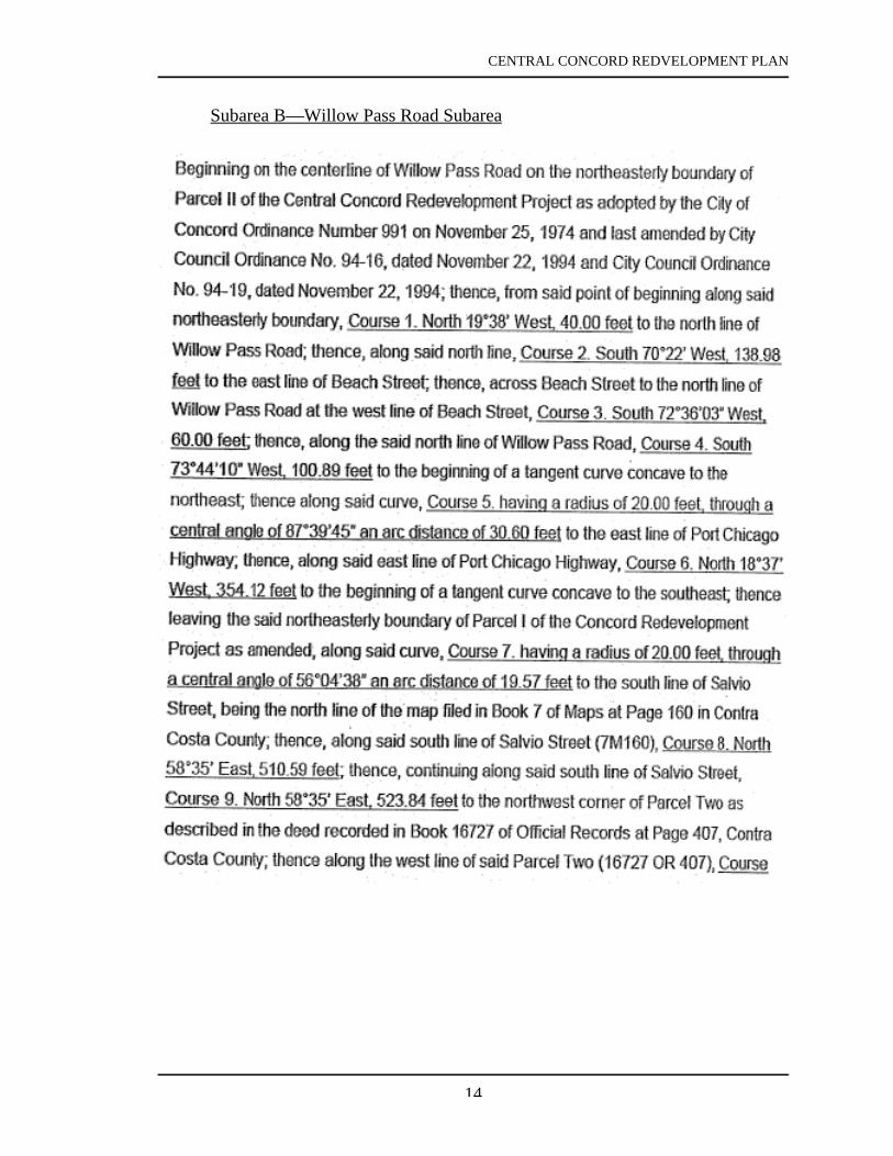
Subarea B—Willow Pass Road Subarea

CENTRAL CONCORD REDVELOPMENT PLAN
15

CENTRAL CONCORD REDVELOPMENT PLAN
16

CENTRAL CONCORD REDVELOPMENT PLAN
17

CENTRAL CONCORD REDVELOPMENT PLAN
18

CENTRAL CONCORD REDVELOPMENT PLAN
19

CENTRAL CONCORD REDVELOPMENT PLAN
20

CENTRAL CONCORD REDVELOPMENT PLAN
21

CENTRAL CONCORD REDVELOPMENT PLAN
22

CENTRAL CONCORD REDVELOPMENT PLAN
23
Subarea C—Monument Corridor Subarea

CENTRAL CONCORD REDVELOPMENT PLAN
24

CENTRAL CONCORD REDVELOPMENT PLAN
25

CENTRAL CONCORD REDVELOPMENT PLAN
26

CENTRAL CONCORD REDVELOPMENT PLAN
27

CENTRAL CONCORD REDVELOPMENT PLAN
28

CENTRAL CONCORD REDVELOPMENT PLAN
29

CENTRAL CONCORD REDVELOPMENT PLAN
30
CENTRAL CONCORD REDVELOPMENT PLAN
31
IV. REDEVELOPMENT OBJECTIVES
The Redevelopment Agency of the City of Concord proposes to use the process ofredevelopment to eliminate many aspects of visual, economic, physical and socialblight presently existing within the City of Concord and more specifically within theboundaries set forth within the Central Concord Redevelopment Plan. Within theProject Area there presently exists an undesirable mixture of residential, commercial,and industrial uses. In some parts of the Area physical decline in the integrity ofbuilding improvements is apparent and in some areas there exist advanced stages ofphysical deterioration. In other parts of the Area, an inadequate circulation systemhelps thwart the development of vacant or under-utilized land.
The Area is represented by fragmented parcelization and multiple ownership to thepoint that land assemblage for proper economic utilization of the Area has beenthwarted. The lack of early comprehensive planning as well as the intrusion into theProject Area of new facilities such as BART has led to a condition where the properutilization of land has been unrealized. This misuse of land when considered in lightof fragmented ownership of parcels and the adverse effect the mixture of residential,commercial and industrial uses have in the Area taken as a whole, constitute aphysical, social and economic blighting influence on the Project Area. A furthernegative influence on the entire Area is the lack of an adequate traffic circulationsystem which would unify the various sections and functions of the Project Area. Thedevelopment of an adequate circulation system is necessary for the effectiveredevelopment of the entire Project Area.
The Central objectives of this redevelopment plan are:
1. To establish the Project Area as the center of the community in symbolic,functional and economic terms.
2. To maximize opportunities wherever possible for the retention of existingproperty interests, for local investors as well as for the continuation,revitalization and expansion of existing commercial enterprises within the Area.
3. To accomplish these goals with a minimum displacement of any residentialhomeowner who may wish to remain within the Project Area.
To accomplish these general goals, the Agency will undertake the following majoractivities:
1. The Agency shall undertake to intensify and diversity the existing retail, serviceand entertainment area which surrounds the Plaza.
To accomplish this goal, the Agency may undertake the following activities:

CENTRAL CONCORD REDVELOPMENT PLAN
32
a. Public off-street parking facilities may be provided to the extent necessaryto attract new businesses and to permit expansion of existing businesses.Some segments of streets which are not required for vehicular circulationmay be closed or abandoned in order to create new sites for parkingfacilities, additional private development, or public open space.
b. The Plaza and surrounding street frontages will receive improvedlandscaping treatments as well as other amenities. Grant Street betweenSalvio Street and Park Street may be improved to encourage pedestrianmovement.
c. Controls on building design and signs will help assure a continuity ofamenities around the Plaza and along Grant Street.
2. The Agency shall undertake to expand the City's employment base byencouraging new office development between the BART station and the Plaza.
To accomplish this goal, the Agency may undertake the following activities:
a. Concord Boulevard and Clayton Road may be made a one-way couplet toimprove access into the Area as well as to expedite through trafficmovement. Overhead utilities may be eliminated and street trees may beplanted.
b. Segments of Mt. Diablo Street, Grant Street, Laguna Street and MountainView Street may be closed or abandoned to facilitate assembly of sites fornew project development or for public parking facilities.
c. In the areas adjacent to the rapid transit station a greater intensity ofdevelopment will be encouraged than elsewhere in the City.
3. The Agency shall undertake to expand the City's employment base byencouraging new commercial, office and light industrial development in theArea between 1-680 and Route 242.
The Agency shall undertake to eliminate the inadequate traffic circulationsystem throughout the Project Area which is necessary for the effectiveredevelopment of the entire Project. To accomplish this goal, the Agency mayundertake the following activities:
a. The Agency may assist in construction of new on ramps and off ramps atthe four intersections at Willow Pass Road and Concord Avenue with thetwo freeways.

CENTRAL CONCORD REDVELOPMENT PLAN
33
b. Willow Pass Road and Concord Avenue may both be widened.
c. Six streets in the West Concord Area may be extended. A new street maybe constructed.
d. The City of Concord sewer farm may be redeveloped with new public andprivate facilities.
e. Improved Via de Mercados and Commerce Avenue in terms of surfacequality and expansion to handle increased traffic capacities.
f. Pine Creek may be bridged as an extension of Via de Mercados and as anextension of widened Commerce Avenue.
g. Walnut Creek may be bridged as part of an extension of Galaxy Way.
Other objectives for redevelopment of the Project Area are:
1. To locate public facilities in the Project Area whose character will enhance thedowntown Area.
2. To provide new opportunities for living close to BART and to jobs and to guidea major share of City's future population growth in the downtown Area.
To accomplish this goal, the Agency may undertake the following activities:
a. Residential densities which are higher than elsewhere in the City may bepermitted within walking distance of rapid transit.
3. To unify various segments of the Project Area so that they become functionallyand visually one interrelated center for a variety of activities.
To accomplish this goal, the Agency may undertake the following activities:
a. Public improvements such as new bridges, streets and other public ways,plus tree planting, distinctive street lighting and special sidewalk designmay be used to unify the Area visually.
b. In addition to the traffic circulation improvements set forth above in thisSection, Redevelopment Objectives, the “sewer farm” area will beimproved and may include a publicly owned and development recreationfacility.

CENTRAL CONCORD REDVELOPMENT PLAN
34
In addition to the above-stated objectives, the following general goals and objectivesare recognized by the Agency:
1. The Agency shall attempt to avoid any undesirable impact of Project activitiesupon adjacent areas outside the Project Area.
2. The Agency shall attempt to provide whatever public improvements may beneeded to support other objectives of the Redevelopment Plan. Suchimprovements may be in any part of the Project Area, or beyond Projectboundaries where essential to the success of the Project.
a. Other improvements such as sanitary and storm sewer facilities, trafficcontrol devices and utility upgrading will be installed as required forsupport of Project activities.
3. The Agency shall attempt to further the City's housing objectives, especially asthey may be appropriate to the redevelopment Project Area; specifically, theAgency will promote the following objectives:
a. Promote the availability of suitable housing at a reasonable cost for allincome groups residing or wishing to reside in Concord.
b. Encourage the expansion of housing opportunities for special need groups,such as elderly, handicapped and low-income persons.
c. Strive for equal housing opportunity and access for Concord citizensregardless of race, color, religion, national origin, sex, or marital/familystatus.
d. Insure the preservation of older and historical areas, homes and buildings.
e. Promote the development and continuance of a variety of housing typesand designs.
f. Encourage and preserve the compatibility of land uses and the orderlytransition of densities as they relate to the preservation of neighborhoodsand homes.
In addition to the above stated objectives of the Plan, the specific objectives for theAdded Area of the Plan are: to eliminate blighting conditions which have preventedthe proper utilization of buildings or land in the Added Area including, among others,deficient or deteriorated buildings, inadequate or unsafe pedestrian and vehicularcirculation and access, lots or buildings of inadequate size or substandard design,incompatible uses, properties containing hazardous wastes, and inadequate public

CENTRAL CONCORD REDVELOPMENT PLAN
35
improvements, facilities or utilities; to strengthen commercial and light industrialfunctions in the Added Area; to expand, improve and preserve the community’ssupply of low- and moderate-income and market-rate housing; to provide adequateland for parking and open spaces; to replan, redesign and develop areas which arestagnant or improperly utilized; to assemble land into parcels suitable for modern,integrated development with improved pedestrian and vehicular circulation; toprovide opportunities for participation by owners and tenants in the revitalization oftheir properties; and to install needed public improvements to stimulate newresidential, commercial and light industrial expansion, employment and economicgrowth in the Added Area, and to assist in continuing to stimulate redevelopment ofthe Original Project Area. Another objective for the Added Area of the Plan is to helpimplement the General Plan’s land use and development goals and objectives for theAdded Area.
To accomplish these goals and objectives, the Agency may undertake the followingactivities or programs:
1. Circulation, landscaping, parking and beautification improvements, publicfacilities and infrastructure, as more specifically described in paragraph F.2 ofSection V of this Plan.
2. Activities or programs to stimulate economic development, such as: providingincentives for private sector investment in underutilized and vacant areas;promoting mixed-use development and facilitating development of office,residential, business and industrial park development in conformance with theGeneral Plan; enhancing and improving existing commercial and residentialdevelopment; providing financial and technical assistance to supportneighborhood commercial uses; helping promote business associations and theiractivities; and continuing to implement activities designed to strengthen existingindustrial and commercial areas and attract new businesses, shoppers and jobs.
3. Building rehabilitation activities and programs, such as: providing assistance forseismic strengthening of commercial buildings; encouraging buildingrehabilitation; providing incentives for private sector redevelopment ofdilapidated and abandoned buildings; promoting the renovation or removal ofobsolete, substandard and deteriorated or aged commercial and residentialstructures; and providing incentives to eliminate blighted buildings that are athreat to health and safety.
4. Site preparation and development activities and programs, such as: continuing tofacilitate hazardous materials assessment and cleanup; assisting in propertyacquisition and site assembly; providing assistance to relocate incompatibleuses; and facilitating development projects that could include existing owner andbusiness tenant participation.
CENTRAL CONCORD REDVELOPMENT PLAN
36
5. Affordable housing activities and programs, such as: implementing programs torehabilitate and upgrade the existing housing stock and provide additionalhousing opportunities for very low-, low- and moderate-income households;providing increased affordable home ownership opportunities through mortgageassistance for first-time homebuyers; providing housing support services andensuring fair housing is available in Concord; and developing infill housing forhome ownership opportunities and rental housing including, but not limited to,property tax assistance, Cal HFA loan assistance, and capital improvementfunding.

CENTRAL CONCORD REDVELOPMENT PLAN
37
V. REDEVELOPMENT TECHNIQUES TO ACHIEVE PLANOBJECTIVES
The redevelopment of the Central Concord Redevelopment Project will be undertakenin accordance with the provision of the California Community Redevelopment Law.
The Agency proposes to strive for economic, social and physical revitalization andbeautification within the Project Area by:
1. Installation, construction, or reconstruction of streets, utilities, landscaping, andother on-site and off-site improvements.
2. Redevelopment of land by private enterprise or public agencies for use inaccordance with this Plan.
3. Providing for open space and recreational land use.
4. Rehabilitation and rejuvenation of existing structures.
5. Limited acquisition of real property.
6. Relocation assistance to displaced residential and non-residential occupants.
7. Demolition or removal of buildings and improvements.
8. Disposition of property for uses in accordance with this Plan.
A. Participation by Owners and Business Tenants
1. Opportunities for Owners and Business TenantsThe Agency shall extend reasonable preferences to persons who areengaged in business in the Project Area, to continue or re-enter in businesswithin the Redevelopment Area if they meet the requirements prescribed inthis Plan. For that purpose the Agency has adopted rules for re-entry ofbusiness in the Project Area.
It is the policy of the Agency to encourage the participation of propertyowners and businesses within the Project Area as such is necessary if theredevelopment process is to be successful in revitalizing Central Concord.
It is further the policy of the Agency to refrain from the acquisition of realproperty within the Project Area from owners who wish to remain andparticipate in the redevelopment of their property. To the extent possiblethe Agency shall attempt to acquire property only where there is a

CENTRAL CONCORD REDVELOPMENT PLAN
38
willingness to sell on the part of the private property owner. It isanticipated that the acquisition of real property within the Project Area willbe limited and that the Agency's power of eminent domain will be usedonly in those rare instances in which the Agency determines that theacquisition of certain real property is necessary and is in the best interest ofthe Project. It is the policy of the Agency to minimize acquisition ofprivate property when possible and to vigorously pursue theencouragement of participation within the redevelopment program ofproperty owners and businesses within the Project Area. Said participationshall be pursued by the Agency by allowing owners of parcels of realproperty to: retain all or a portion of their properties; to acquire adjacent orother properties in the Project Area; and to upgrade and develop theirproperty in conformance with this Plan.
In the event a participant fails or refuses to rehabilitate or develop his orher real property pursuant to this Plan and/or the participation agreements,as an alternate hereto, the Agency is authorized but is not required toacquire the real property or any interest therein which if acquired may besold or leased for rehabilitation or development in accordance with thisPlan and the rules for owner participation.
The Agency may determine that certain real property within the ProjectArea presently meets the requirements and objectives of this Plan and theowners of such properties will be permitted to remain as conformingowners without a participation agreement with the Agency, provided suchowners continue to operate and use the real property within therequirements of this Plan.
The Agency may also determine that certain real property within theProject Area is substantially in conformance with the requirements andobjectives of this Plan and the owners of such properties shall be allowedto remain as conforming owners provided said owners adequatelylandscape such property.
The Agency shall not acquire, through the use of eminent domain,conforming property owned by conforming owners when established by aresolution of the Agency as set forth in Section B(1) infra.
In the event any of the conforming owners desire to: 1) construct anyadditional improvements or substantially alter or modify existing structureson any of the real property described above as conforming; or 2) acquireadditional real property within the Project Area, then such conformingowners shall be required to enter into a participation agreement with theAgency in the same manner as required for owners of non-conforming

CENTRAL CONCORD REDVELOPMENT PLAN
39
properties.
2. Rules for Participation Opportunities, Priorities, and PreferencesOwners of property and business tenants may participate in theredevelopment of property in the Project Area in accordance with thePreference Rules and Participation Rules adopted or subsequently amendedby the Agency. In general, these rules provide that in the event ofdisplacement as a result of Agency activities existing business owners andbusiness tenants within the Project Area will be given preference for re-entry into business within the redeveloped Project Area. Owners will berequired to submit proof to the Agency of their qualifications and financialability to carry out their agreement with the Agency.
3. Participation AgreementsEach participant, not a conforming owner, shall enter into a bindingagreement with the Agency by which the participant agrees to rehabilitate,develop, or use the property in conformance with the Plan and to be subjectto the provisions hereof. In such agreements, participants who retain realproperty shall be required to join in the recordation of such documents asare necessary in the determination of the Agency to make the provisions ofthis Plan applicable to their properties.
B. Property Acquisition
1. Acquisition of Real PropertyExcept as specifically exempted herein, the Agency may, but is notrequired to, acquire or obtain options to acquire real property located in theProject Area, by gift, devise, exchange, purchase, eminent domain or anyother lawful method whatsoever. The Agency may also acquire any otherinterest in real property less than a fee interest.
Since it is in the public interest and is necessary for the elimination ofthose conditions requiring redevelopment, the power of eminent domainmay be employed by the Agency in some instances to acquire real propertyin the Project Area.
However, said power of eminent domain will not be exercised when:
a. The property in question is improved with a structure and the Agencyhas determined by resolution that the rehabilitation of the structureand its proposed use is consistent with the objectives of the Plan andthat such rehabilitation is in the best interest of project and the ownerhas thereafter entered into an owner participation agreement with theAgency and is faithfully performing under the terms of the

CENTRAL CONCORD REDVELOPMENT PLAN
40
agreement.
b. The property in question is improved by a structure and the Agencyhas determined by resolution that said structure and its use isconsistent with the objectives of the Plan, that such propertyconforms to the Plan and that no owner participation agreement isnecessary so long as the structure is adequately maintained andlandscaped.
c. The property in question is owned by a public body.
Prior to any acquisition through eminent domain the Agency shalladopt a resolution declaring a need to acquire any specific propertyand authorizing the acquisition by such a method.
The Agency is not authorized to acquire real property owned bypublic bodies which do not consent to such acquisition. The Agencyis authorized, however, to acquire property devoted to a public use, ifit is transferred to private ownership before the Agency completesland disposition within the entire Project Area, unless the Agency isauthorized to acquire such property under other provisions of thisPlan.
d. As set forth in Ordinance No. 94-19 amending the Plan, within theOriginal Project Area the Agency shall not commence eminentdomain proceedings after November 22, 2010.
Within the Added Area, the Agency shall not commence eminentdomain proceedings after the date that is twelve (12) years afteradoption of the ordinance approving Amendment No. 13 to the Plan.In addition, within the Added Area, the Agency is not authorized toacquire, by eminent domain: (1) any property that is zoned to allowresidential uses and lawfully used for residential purposes as of thedate of adoption of the ordinance approving Amendment No. 13 tothe Plan, except for two parcels located within the Willow Pass RoadSubarea (Subarea B of Parcel V of the Project Area), located at 2520Salvio Street and 1985 Beach Street and generally known as AssessorParcel Numbers 111-222-002 and 111-222-003; or (2) any propertythat is located within Subarea A of Parcel V of the Project Area.
The time limits on commencing an action in eminent domain cannotbe extended without further amendment to this Plan.

CENTRAL CONCORD REDVELOPMENT PLAN
41
2. Acquisition of Personal PropertyGenerally, personal property shall not be acquired. However, wherenecessary in the execution of this Plan, the Agency is authorized to acquirepersonal property in the Project Area by any lawful means.
C. Cooperation with Public Bodies
Certain public bodies are authorized by State law to aid and cooperate, with orwithout consideration, in the planning, undertaking, construction, or operation ofthis Project. The Agency shall seek the aid and cooperation of such publicbodies and shall attempt to coordinate this Plan with the activities of such publicbodies in order to accomplish the purposes of redevelopment and the highestpublic good.
The Agency by law is not authorized to acquire real property owned by publicbodies without the consent of such public bodies. The Agency, however, willseek the cooperation of all public bodies which own or intend to acquireproperty in the Project Area. The Agency shall have the right to impose on allpublic bodies the planning and design controls contained in the Plan to insurethat present uses and any future development by public bodies conform to therequirements of this Plan. Any public body which owns or leases property in theProject Area will be afforded all the privileges of owner and tenant participationif such public body is willing to enter into a participation agreement with theAgency.
D. Property Management
During such time as property in the Project Area is owned by the Agency, suchproperty shall be. under the management and control of the Agency. Suchproperty may be rented or leased by the Agency pending its disposition forredevelopment. In any year during which the Agency owns property in theProject Area, the Agency may, but shall not be required to, pay to the City ofConcord, Contra Costa County or any district or other public corporation whichwould have levied a tax upon such property had it not been exempt an amount ofmoney in lieu of taxes; provided that no such payment shall be made for anyperiod during which such property is devoted to a public use.
E. Relocation of Persons Displaced
When undertaken, the relocation of persons and businesses will be subject to thefollowing standards:
1. Assistance in Finding Other LocationsThe Agency shall assist all families and single persons displaced by theProject in finding other locations and facilities. There are in areas of theCity of Concord, other than the Project Area (areas not generally less

CENTRAL CONCORD REDVELOPMENT PLAN
42
desirable in regard to public utilities and public land commercial facilitiesand at rents or prices within the financial means of the families and personsdisplaced from the Project Area), decent, safe and sanitary dwellings equalin number to the number of and available to such displaced families andpersons and reasonably accessible to their places of employment. In orderto carry out the Project with a minimum of hardship to persons displacedfrom their homes, the Agency shall assist individuals and families infinding housing that is decent, safe, sanitary, within their financial means,in reasonable convenient locations, and otherwise suitable to their needs.The Agency is also authorized to provide housing outside the Project Areafor displaced persons.
2. Relocation PaymentsThe Agency may pay reasonable moving expenses to persons (includingfamilies, business concerns and others) displaced by the Project. Thisprovision is not intended to provide incentives for commercial andindustrial businesses to move out of the Project Area. The Agency maymake such relocation payments for moving expenses where the Agencydetermines it is in the best interest of the Project and not to do so wouldcreate a hardship on the persons involved. The Agency may make suchother payments as may be in the best interest of the Project and for whichfunds are available. The Agency shall make all relocation paymentsrequired by applicable law.
F. Demolition, Clearance, Public Improvements, Building and SitePreparation
1. Demolition and ClearanceThe Agency is authorized to demolish, clear or move buildings, structures,and other improvements from any real property owned or acquired by theAgency in the Project Area as necessary to carry out the purposes of thisPlan.
2. Public ImprovementsThe Agency is authorized to install and construct or to cause to be installedand constructed the public improvements and public utilities (within oroutside the Project Area) necessary to carry out this Plan. Such publicimprovements include, but are not limited to, over or underpasses, bridges,streets, curbs, gutters, sidewalks, street lights, sewers, storm drains, trafficsignals, electrical distribution systems, natural gas distribution systems,water distribution systems, buildings, parks, off-street parking, plazas,playgrounds, and landscaped areas.
For portions of the Project Area added to the Plan boundaries after October

CENTRAL CONCORD REDVELOPMENT PLAN
43
1, 1976 it is anticipated that the following public improvements includingthe costs of property acquisition, site preparation, design and construction,will be undertaken:
a. The development of the abandoned Concord Sewage TreatmentFacility to include a potential for open space and/or recreationalfacilities.
b. New and/or improved on and off ramps linking freeway 680 atConcord Avenue, Willow Pass Road, and Galaxy Way.
c. New and/or improved on and off ramps linking State Route 242 toDiamond Boulevard and Meadow Lane; Willow Pass Road; ClaytonRoad; Commerce Lane.
d. New and/or improved streets including (i) extension of Galaxy Way,John Glenn Drive, Burnett Avenue, Meridian Boulevard, Via deMercados, Hotel Way, Commerce Avenue; (ii) widening of ConcordAvenue and Willow Pass Road; (iii) construction of a new streetserving The Willows; (iv) Willow Pass Road/Clayton Road “S”curve.
e. As an alternative to some improvements listed above, development ofexpanded public mass transit system from the BART Stationthroughout the Project Area to reduce the dependence upon privateautomobiles.
For the Added Area, the Agency is specifically authorized to undertake thefollowing public improvements:
i. The improvement, construction and reconstruction of roadway,streetscape and transportation-related improvements to improvecirculation and access, such as street widenings, new landscapedmedians and dedicated turn lanes.
ii. The facilitation of transit improvements, such as improvements to busstops and shelters.
iii. The provision of improvements to promote pedestrian-oriented usesand linkages, such as street furniture, sidewalks, traffic signals andcrosswalks.
iv. The construction of walking and bicycle trails, street lighting andlandscape improvements.

CENTRAL CONCORD REDVELOPMENT PLAN
44
v. The provision of improvements to unify corridors, such asconstruction of gateways through landscaping to frame views,landscaping of median island planter strips, streetscape signage andfaçade improvements, and enhancement of historical elements.
vi. The provision of adequate parking and signage to enhance theefficiency of commercial uses.
vii. The improvement of public infrastructure, such as water, sewer,wastewater, storm drainage and flood control systems.
viii. The undergrounding of electrical utilities.
ix. The widening of bridges over flood control channels where traffic iscurrently constricted.
x. The rehabilitation, installation, acquisition and improvement of parks,playgrounds, libraries and other public buildings and structures.
3. Preparation of Building and Development SitesThe Agency is authorized to prepare or cause to be prepared as buildingand development sites any real property in the Project Area owned oracquired by the Agency.
4. Landmark PreservationNo building which has been designated a landmark pursuant to the City'sLandmark Preservation Ordinance shall be subject to demolition.
G. Rehabilitation and Moving of Structures by the Agency
1. RehabilitationThe Agency is authorized to rehabilitate or to cause to be rehabilitated anybuilding or structure in the Project Area required by the Agency. TheAgency is also authorized and directed to advise, encourage, and assist inthe rehabilitation of property in the Project Area not acquired by theAgency.
2. Moving StructuresAs necessary in carrying out this Plan, the Agency is authorized to move orto cause to be moved any building or other structure to a location within oroutside the Project Area.
H. Property Disposition and Development

CENTRAL CONCORD REDVELOPMENT PLAN
45
1. Real Property Disposition and Developmenta. General
For the purposes of this Plan, the Agency is authorized to sell, lease,exchange, subdivide, transfer, assign, pledge, encumber by mortgageor deed or trust, or otherwise dispose of any interest in real property.To the extent permitted by law, the Agency is authorized to disposeof real property by negotiated leases or sales without public bidding.
All real property acquired by this Agency in the Project Area shall besold or leased for development for the uses permitted in the Plan.Real property may be conveyed by the Agency to the City or anyother public body without charge. Property containing buildings orstructures rehabilitated by the Agency shall be offered for resalewithin one year after completion of rehabilitation or an annual reportconcerning such property shall be published by the Agency asrequired by law.
The Agency shall reserve such powers and controls in the dispositionand development documents as may be necessary to prevent transfer,retention, or use of property for speculative purposes and to insurethat development is carried out pursuant to this Plan.
b. Purchase and Development by ParticipantsPursuant to the provisions of this Plan and the rules adopted by theAgency, the Agency may offer real property in the Project Area forpurchase and development by owner and business-tenant participantsprior to the time that real property is made available for purchase anddevelopment by persons who are not owners or business tenants inthe Project Area.
c. Purchase and Development DocumentsTo provide adequate safeguards to insure that the provisions of thisPlan will be carried out and to prevent the recurrence of blight, allreal property sold, leased, or conveyed by the Agency, as well as allproperty subject to participation agreements, shall be made subject tothe provisions of this Plan by leases, deeds, contracts, agreements,declarations of restrictions, provisions of the Zoning Ordinance,conditional use permits, or other means.
Where appropriate, as determined by the Agency, such documents orportions thereof shall be recorded in the office of the Recorder of theCounty.The leases, deeds contracts, agreements, and declarations ofrestrictions may contain restrictions, covenants, covenants running

CENTRAL CONCORD REDVELOPMENT PLAN
46
with the land, rights of reverter, conditions subsequent, equitableservitude, or any other provision necessary to carry out this Plan.
All property in the Project Area is hereby subject to the restrictionthat there shall be no discrimination or segregation based upon race,religion, sex, or national origin, in the sale, lease, sublease, transfer,use, occupancy, tenure, or enjoyment of property in the Project Area.All property sold, leased, conveyed, or subject to a participationagreement shall be made expressly subject by appropriate documentsto the restriction that all deeds, leases, or contracts for the sale, lease,sublease, or other transfer or use, occupancy, tenure or enjoyment ofland in the project Area shall contain such nondiscrimination andnonsegregation clauses as are required by law, and as set forth onpage 20. Appropriate covenants running with the land which willprohibit such restrictions shall be included in the dispositiondocuments.
d. DevelopmentTo the extent now or hereafter permitted by law, the Agency isauthorized to pay for all or part of the value of the land and the costof the installation and construction of any building, facility, structure,or other improvements either within or outside the Project Area foritself or for any public body or entity to the extent that suchimprovements would be of benefit to the Project Area.
During the period of development in the Project Area, the Agencyshall insure that the provisions of this Plan and of other documentsformulated pursuant to this Plan are being observed, and thatdevelopment in the Project Area is proceeding in accordance withdevelopment documents and time schedules.
The Agency shall require that development plans on propertyacquired from the Agency or on property subject to an ownerparticipation agreement be submitted to Agency staff for approvaland review. All development must conform to this Plan and allapplicable Federal, State, and local laws, except as such may bemodified by requirements of this Redevelopment Plan or Agencyagreements entered into to carry out the purposes of this Plan.
e. Obligations to be Imposed on Redevelopers(1) Purchasers of land acquired from Agency or subject to an owner
participation agreement within the Project Area shall berequired to develop such land in accordance with the provisionsof this Plan. No building, sign, or structure shall be constructed

CENTRAL CONCORD REDVELOPMENT PLAN
47
upon any part of such land unless architectural plans andspecifications, showing the nature of such construction, parking,loading, surface treatment and landscaping, the location andorientation of structure(s) on the building site and, whenrequested, the grading plans for the building site to be builtupon, shall have been submitted to, reviewed and approved inwriting by the Agency. The Agency shall have the right torefuse to approve any such plans or specifications when in theopinion of the Agency such plans or specifications do notconform with the conditions and objectives of the Plan.
(2) Acquirers, users or developers of land acquired from Agency orsubject to an owner participation agreement within the ProjectArea must commence the erection of any building, prosecutediligently the work thereon and complete it within suchreasonable period of time as agreed upon with the Agency.
(3) Persons who are engaged in business in the Project Area shall begranted preference by the Redevelopment Agency to re-enter inbusiness within said Area after redevelopment if they otherwisemeet the requirements prescribed by the Plan.
(4) The acquirer, user, or owner shall be responsible for complyingwith all applicable State and local laws, ordinances and codes,in effect from time to time, not superseded by this Plan.
2. Personal Property DispositionFor the purpose of this Plan, the Agency is authorized to sell, lease,exchange, transfer, assign, pledge, encumber, or otherwise dispose ofpersonal property.
I. Prevention of Discrimination
1. RedevelopmentThe redeveloper shall comply with all State and local laws, in effect fromtime to time, prohibiting discrimination or segregation by reason of race,religion, sex, or national origin, in the sale, lease or occupancy of theproperty. Pursuant to California Health and Safety Code (Sections 33337and 33435-33436), contracts entered into by the Agency relating to thesale, transfer or leasing of land, or any interest therein acquired by theAgency within any Redevelopment Area or project, the provisions of saidSection in substantially the form set forth therein shall be included in suchcontracts, and such contracts shall further provide that the provisions ofsaid Section shall be binding upon and shall obligate the contracting party

CENTRAL CONCORD REDVELOPMENT PLAN
48
or parties and any subcontracting party or parties and all other transfereesunder the instrument.
2. ContractsAll deeds, leases or contracts for the sale, lease, sublease or other transferof any land in the Project Area shall contain the followingnondiscrimination clauses as prescribed by California Health and SafetyCode, Section 33236:
In deeds, the following language shall appear:The grantee herein covenants by and for himself, his heirs,executors, administrators and assigns, and all personsclaiming under or through them, that there shall be nodiscrimination against, or segregation of, any person orgroup of persons on account of race, religion, sex, ornational origin, in the sale lease, sublease, transfer, use,occupancy, tenure, or enjoyment of the premises hereinconveyed, nor shall the grantee himself or any personclaiming under or through him establish or permit any suchpractice or practices of discrimination or segregation withreference to the selection, location, number, use oroccupancy of tenants, lessees, subtenants, sublessees, orvendees in the premises herein conveyed. The foregoingcovenants shall run with the land.”
In leases, the following language shall appear:“The lessee herein covenants by and for himself, his heirs,executors, administrators, and assigns, and all personsclaiming under or through him, and this lease is made andaccepted upon and subject to the following conditions: Thatthere shall be no discrimination against or segregation of anyperson or group of persons, on account of race, religion, sex,or national origin, in the leasing, subleasing, transferring,use, occupancy, tenure, or enjoyment, of the premises hereinleased, nor shall the lessee himself, or any person claimingunder or through him, establish or permit any such practiceor practices of discrimination or segregation with referenceto the selection, location, number, use, occupancy, ortenants, sublessees, subtenants, or vendees in the premises ofherein leased.”
3. DurationThe covenants in deeds, leases, and contracts or with the Agency, withrespect to Prevention of Discrimination, shall remain in effect inperpetuity.

CENTRAL CONCORD REDVELOPMENT PLAN
49
VI. PERMITTED LAND USES
The permitted land uses in the Project Area and the intensity and density of those usesshall be those set forth in the City of Concord General Plan as that General Plan nowexists or as it may be amended in the future. The land uses for the Project Area shownon the Land Use Map (Exhibit B, Revised 2006) are the uses for the Project Area asset forth in the City of Concord General Plan as it exists at the time of adoption of theordinance approving Amendment No. 13 to the Plan. If there are future amendmentsto the General Plan that affect the land uses in the Project Area, the Agency willrevise the Land Use Map (Exhibit B, Revised 2006) to reflect those changes in theGeneral Plan and attach it to this Plan. As a result, the land uses of the Project Areashall always conform to the City of Concord General Plan.
A. Land Use Map
The Land Use Map attached hereto as Exhibit B, Revised 2006, shows thepermitted land uses and major circulation routes within the Project Area.
B. Streets and Rights-of-way
The existing public streets within the Project Area are depicted on Exhibit B. Allstreets within the Project Area may be widened, altered, or vacated for purposesof development of the project. New streets may be created as necessary. Thesepublic rights-of-way shall be used for vehicular and/or pedestrian traffic as wellas for public improvements, public and private utilities, and activities typicallyfound in public right-of-way. Any and all street vacations pursuant to this Planshall be in accordance with the City's public hearing requirements as well as allother applicable law including, but not limited to, those provisions set forth inthe California Streets and Highways Code.
C. General Controls and Limitations
All real property in the Project Area is hereby made subject to the controls andrequirements of this Plan.
No real property shall be developed, rehabilitated, or otherwise changed afterthe date of the adoption of the Plan except in conformance with the provisions ofthis Plan and all applicable State and local laws in effect from time to time.
1. New ConstructionAll new construction shall comply with all applicable State and local lawsin effect from time to time, except as inconsistent with this Plan oragreements entered into by the Agency under the authority of this Plan.
2. Existing Non-Conforming Uses

CENTRAL CONCORD REDVELOPMENT PLAN
50
The Agency is authorized to permit an existing use to remain in an existingbuilding in good physical condition which does not conform to theprovisions of this Plan provided that such use is generally compatible withthe developments and uses within the Project Area.
3. RehabilitationAny structure within the Project Area which will be retained as part of theRedevelopment Plan shall not be repaired, altered, reconstructed, orrehabilitated unless it is done so in conformance with the RedevelopmentPlan and any and all guidelines which may be adopted by the Agency toassist in the implementation of the Plan. This conformity shall extend tothe architectural character, the public spaces and other elements as requiredby the Agency.
4. Open Spaces and LandscapingThe approximate amount of open space to be provided within the ProjectArea is set forth in Exhibit B and is included as part of the goals andobjectives of this Plan. These areas include, but are not limited to, the totalof all areas which will be in the public rights-of-way, open space areas, thespace around buildings, and all other outdoor areas not permitted throughapplicable limits of land coverage to be covered by buildings. Landscapingplans shall be required to be submitted to the Agency for review andapproval.
5. SignsExterior signs necessary for the identification of buildings and premisesshall be permitted provided that they comply with the design criteriaestablished for the Project Area. The Agency may require that the completesign program be reviewed by the Agency staff as well as the City's DesignReview Board prior to their erection or installation in any area within theRedevelopment boundaries.
6. UtilitiesThe Redevelopment Agency shall require that all utilities be placedunderground including, but not limited to, the following: transformervaults or pads, water meters and valves, telephone pull boxes, manholeinlets and drain facilities, and cable TV.
7. Incompatible UsesNo use or structure which by reason of appearance, traffic, smoke, glare,noise, odor, or other similar factors that would be incompatible with thesurrounding areas or structures shall be permitted in any part of the ProjectArea.

CENTRAL CONCORD REDVELOPMENT PLAN
51
8. Nondiscrimination and NonsegregationThere shall be no discrimination or segregation based on race, religion, sexor national origin, permitted in the sale, lease, sublease, transfer, use,occupancy, tenure, or enjoyment of property in the Project Area.
9. Resubdivision of ParcelsAfter rehabilitation and development pursuant to this Plan, no parcel in theProject Area, including any parcel retained by a conforming owner orparticipant, shall be resubdivided without the approval of the Agency.
10. VariationsUnder exceptional circumstances, the Agency is authorized to permitvariations from the limits, restrictions, and controls established by the Plan.In order to permit such a variation, the Agency must determine that:
a. The application of one or more of the provisions of the Plan wouldresult in unnecessary hardship to the property owners; and
b. There are exceptional circumstances or conditions applicable to theproperty or to the intended development of the property which do notapply generally to other properties having the same standards,restrictions, and controls; and
c. Permitting a variation from the limits, restrictions, or controls of thisPlan will not be materially detrimental to the public welfare orinjurious to property or improvements in the Area; and
d. Permitting a variation will not be contrary to the objectives of thisPlan.
No such variation shall be granted which changes a basic land use pursuantto this Plan or which permits other than a minor departure from theprovisions of this Plan. In permitting any such variation, the Agency shallimpose such conditions as are necessary to protect the public health, safety,or welfare, and to assure compliance with the objectives of the Plan.
D. Standards for Development
Within the limits, restrictions and controls established in the Plan, the Agency isauthorized to establish development and design controls necessary to implementthe Plan. Said controls would relate to both private and public areas within theProject Area.
In addition development will also comply with the specific development

CENTRAL CONCORD REDVELOPMENT PLAN
52
standards applicable under the Concord Municipal Code. In the absence of morespecific controls the Land Use Element of the City's General Plan shall governdevelopment standards.
E. Building Permits
1. Review of ApplicationsUpon the adoption of this Plan, no permit shall be issued for theconstruction of any new building or the addition to an existing building orany permit for rehabilitation in the Project Area until the application forsuch permit has been processed in the manner herein provided. Any permitthat is issued hereunder must be for construction or maintenance whichconforms to the provisions of this Plan.
The procedure for filing an application for a building permit shall be thesame procedure currently used by the City in processing building permitapplications. Upon receipt of an application by the Building Division, theBuilding Division shall submit to the Executive Director (or the authorizeddesignee of the Executive Director) or the Redevelopment Agency saidapplication for review to determine if the proposed improvements conformto the Redevelopment Plan. Within fifteen (15) days thereafter, theExecutive Director shall submit a report to the Building Division on saidapplication. Said report shall:
1. Deny the application; or
2. Approve the application; or
3. Approve the application with modifications or conditions felt to benecessary to the Executive Director.
After receipt of the report or after 15 days from the submittal of theapplication to the Executive Director, whichever first occurs, the BuildingDivision may issue the permit with conditions, if any, as set forth in theExecutive Director's report, or may deny the issuance of the permitpursuant to the Executive Director's report.
2. AppealThe applicant or the Agency may appeal the Building Division's decisionto withhold, to conditionally allow, or to allow the issuance of such apermit pursuant to established City procedures.

CENTRAL CONCORD REDVELOPMENT PLAN
53
VII. NEIGHBORHOOD IMPACT STATEMENT
The purpose of this section is to describe the impact of the project upon the residentsof the area and the surrounding areas in terms of relocation, traffic circulation,environmental quality, availability of community amenities and services, on schoolpopulation and quality of education, property assessments and taxes as well as othermatters affecting the physical and social quality of the neighborhood.
All these factors are discussed in depth in the Environmental Impact Report(s)prepared for this plan. To include that data herein would be excessively voluminousand unnecessarily repetitive. However, the following is a summary of theconsideration given to the above factors in the development of this Plan.
The Project is designed to eradicate the blighted conditions now prevalent in the Area.For the most part, properties shall be acquired and sites cleared for futuredevelopment in economic parcel sizes which will be intended to eliminatedeteriorated and deteriorating structures present in the Area, and at the same timeeliminate the mixed character of uses which have historically developed due to faultyplanning or the lack of any planning.
In establishing the Project Area boundaries, care was taken to include only thoseportions of the central area in which commercial or other economic activities werelocated. Two small residential enclaves were additionally included since they aresurrounded by commercial or public uses and show signs of adverse changes inupkeep, occupancy or structural condition. Single family dwellings in theneighborhood north of Salvio Street, however, were purposely omitted from theProject. These homes, many of which have historical importance, are thus left intactand retain their stable character and an advantageous proximity to the City core.
An objective of the Redevelopment Project is to minimize the displacement of allresidents. In parts of the Project Area where there are proposed no changes in the useof land or intensity of development, residents who remain are expected to benefitfrom environmental improvement. In the cases where the Plan permits or requireschanges, such that continued residence is not feasible, present residents will seekhousing elsewhere. If such a move is a direct result of Agency activity, residents willbe assisted in their relocation efforts as required by State law, and as specified in theReport on the Redevelopment Plan.
Any detrimental impact on the surrounding residential neighborhoods will be avoidedthrough the appropriate exercise of City powers such as zoning and enforcement ofcodes.
Proposed new development within the California Hill area will help to strengthen andimprove the liveableness of this area by eliminating conflicting land uses, poor street

CENTRAL CONCORD REDVELOPMENT PLAN
54
conditions and deteriorated buildings. Adjacent to Galindo Street near the BARTstation, new multiple units will provide a living environment of quality andconvenience; close to rapid transit service, employment concentrations, pleasant openspaces and retail and entertainment activities.
The Project is anticipated to provide to the community as a whole, and specifically tonearby residential neighborhoods, commercial, civic and office related facilities,goods and services of improved variety and character.
The Redevelopment Plan is designed to expand and diversify public open spaces andto locate new public facilities downtown that will enhance the central area, creating amore viable city focus for community events and gatherings. A principal objective ofthe Project is to provide substantial improvements to pedestrian spaces and pathways.Such amenities as wider sidewalks, street furniture, and landscape treatments willcreate more useable and functional open space within the downtown district. Further,improved pedestrian linkages are proposed not only to unify the area, but to provideconvenient and safe movement from surrounding neighborhoods into the downtownor to the BART station.
Improvement to vehicular circulation in the Project Area is anticipated by this Project,including improved freeway access, stronger east-west connections, more efficientinterior movements, and better direct access to the BART station. A major goal ofthese changes is to develop a street pattern that will restrict heavy traffic volumesaway from residential areas as well as to provide peripheral routes around thepedestrian-oriented Plaza blocks. Automobile, bicycle and pedestrian routes will bedesigned to allow a broad and convenient choice among transit modes to thesurrounding neighborhoods and residential development within the Project Area.Specifically, the expansion of the Project Area to include property added afterOctober 1, 1976 has been designed to implement circulation changes necessary forthe effective redevelopment of the original Project Area and to assist in theimprovement of the vehicular circulation system set forth above. As this area containsno residential uses at present and as none are permitted under the Plan, this additionalarea will have minimal impacts on the surrounding community except to the extentthat the implementation of the redevelopment program in that area will alleviateexisting congestion and circulation problems which are already a burden on thesurrounding neighborhoods.
When completed, the Project may introduce a significant increase in residential unitswithin the Project Area. These multiple units will not likely draw the large familyhousing market, so that very few school-age children will be added to the immediatearea. Also, nearby schools which show declining enrollments are fully able to absorbnew increase in school population with a minimal impact upon the quality ofeducation.

CENTRAL CONCORD REDVELOPMENT PLAN
55
The Central Concord Redevelopment Project is anticipated to be financedsubstantially by tax increment funding. In this way, there will be the least burden intaxes to those business and homeowners within the Project Area as well as to thegeneral property taxpayer in Concord. Upon completion of the Project, sales tax andreal estate tax revenues available to the City of Concord should increase. In light ofthis growth, the assessed value of surrounding neighborhoods should be enhanced. ,
It is a principal objective of the Redevelopment Agency that the improvement of theProject Area will have beneficial effects upon the surrounding neighborhood.
The impacts on residents of the Project Area and the surrounding neighborhoodsdescribed above pertain to the Original Project Area, however, the impacts onresidents of the Added Area and the surrounding neighborhoods are substantially thesame. In establishing the Added Area, care was again taken to minimize displacementof residents. Except for two parcels located in Subarea B of Parcel V of the ProjectArea, within the Added Area, the Agency is not authorized to acquire by eminentdomain properties that are zoned to allow residential uses and lawfully used forresidential purposes as of the date of adoption of the ordinance approvingAmendment No. 13 to the Plan. In addition, the proposed vehicular and pedestrianimprovements, public open space improvements and new and rehabilitation housingprojects proposed for the Added Area will have a beneficial effect on the residentsand surrounding neighborhoods of the Added Area, as they will provide better andsafer vehicular and pedestrian circulation and improve the quality of life for theresidents of the Added Area and the surrounding neighborhoods.

CENTRAL CONCORD REDVELOPMENT PLAN
56
VIII. METHODS FOR FINANCING THE PROJECT
A. General Description of the Proposed Financing Method
Upon adoption of this Plan by the City Council, the Agency is authorized tofinance this Project with financial assistance from the City of Concord, State ofCalifornia, Contra Costa County, Federal Government, property tax increments,interest income, Agency notes and bonds, or any other available source.
The advances for survey and planning and the operating capital foradministration of this project may come through loans from the City. Such loansshall be on terms established by the City and the Agency. The City may alsosupply additional assistance through City loans and grants for various publicfacilities.
As available, gas tax funds from the State of California and the County ofContra Costa may be used toward the cost of the street system and relatedimprovements. There will also be some revenue accruing to the Project frominterest earned on investments of Agency funds.
The Agency is hereby authorized to obtain advances, borrow funds and createindebtedness and other obligations in carrying out this Plan after first submittinga financing summary of each project to the City Council. The principal andinterest on such advances, funds, indebtedness and other obligations may bepaid from tax increments or any other funds available to the Agency.
B. Tax Increments
All taxes levied upon taxable property within the Project Area each year, by orfor the benefit of the State of California, the County of Contra Costa, the City ofConcord, any district or any other public corporation (hereinafter sometimescalled “taxing agencies”) after the effective date of the ordinance initiallyapproving this Plan (and, where applicable, after the effective date, of anyordinance amending the Plan to add territory to the Project Area), shall bedivided as follows:
1. That portion of the taxes which would be produced by the rate upon whichthe tax is levied each year by or for each of said taxing agencies upon thetotal sum of the assessed value of the taxable property in the Project asshown upon the assessment roll used in connection with the taxation ofsuch property by such taxing agency, last equalized prior to the effectivedate of such ordinance, shall be allocated to and when collected shall bepaid into the funds of the respective taxing agencies as taxes by or for saidtaxing agencies on all other property are paid (for the purpose of allocatingtaxes levied by or for any taxing agency or agencies which did not include

CENTRAL CONCORD REDVELOPMENT PLAN
57
the territory of the Project on the effective date of such ordinance but towhich such territory is annexed or otherwise included after such effectivedate, the assessment roll of the County of Contra Costa last equalized onthe effective date of said ordinance shall be used in determining theassessed valuation of the taxable property in the Project on said effectivedate).
2. Except as provided in Health and Safety Code §33670(e) or §33492.15,that portion of said levied taxes each year in excess of such amount shallbe allocated to and when collected shall be paid into a special fund of theAgency to pay the principal of and interest on loans, monies advanced to orindebtedness (whether funded, refunded, assumed or otherwise) incurredby the Agency to finance or refinance, in whole or in part, this Project.Unless and until the total assessed valuation of the taxable property in theProject exceeds the total assessed value of the taxable property in theProject as shown by the last equalized assessment roll referred to insubparagraph 1 hereof, all of the taxes levied and collected upon thetaxable property in the Project shall be paid into the funds of the respectivetaxing agencies. When said loans, advances and indebtedness, if any, andinterest thereon, have been paid, all monies thereafter received from taxesupon the taxable property in the Project shall be paid into the funds of therespective taxing agencies as taxes on all other property are paid.
The portion of taxes mentioned in subparagraph B.2 above is hereby irrevocablypledged by the Agency for the payment of the principal of and interest on theadvance of monies, or making of loans or the incurring of any indebtedness(whether funded, refunded, assumed or otherwise) to finance or refinance theProject in whole or in part. The Agency is authorized to make such pledges as tospecific advances, loans and indebtedness as appropriate in carrying out theProject.
Below are the required limits pertaining to the Agency’s financing authority:
1. Limit on Tax Dollars ReceivableWith respect to the Original Project Area, the portion of taxes divided andallocated to the Agency pursuant to subparagraph B.2 above shall notexceed a cumulative total of $2,500,000,000 without further amendment ofthis Plan.
2. Time Limit on Tax Increment Receipt and Repayment ofIndebtednessExcept as provided in Health and Safety Code §§33333.6(g) and (h) and33333.8 or as permitted under any existing or future provision of theCalifornia Community Redevelopment Law or other statute, the Agency
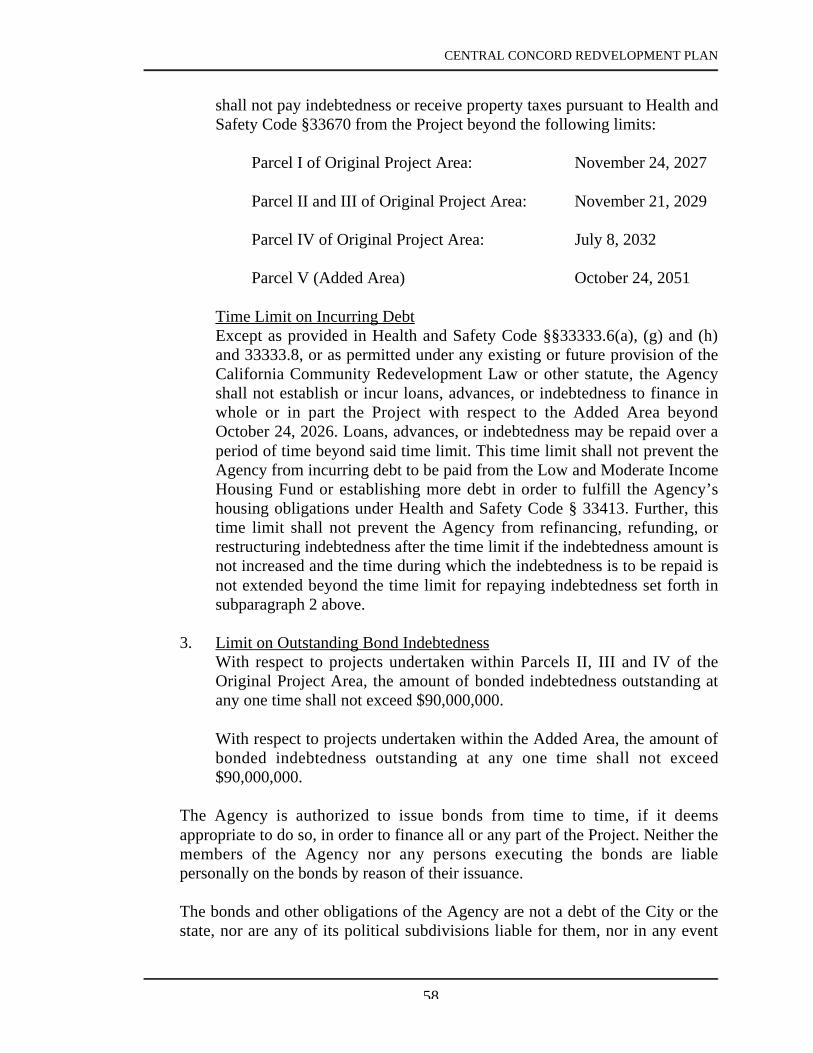
CENTRAL CONCORD REDVELOPMENT PLAN
58
shall not pay indebtedness or receive property taxes pursuant to Health andSafety Code §33670 from the Project beyond the following limits:
Parcel I of Original Project Area: November 24, 2027
Parcel II and III of Original Project Area: November 21, 2029
Parcel IV of Original Project Area: July 8, 2032
Parcel V (Added Area) October 24, 2051
Time Limit on Incurring DebtExcept as provided in Health and Safety Code §§33333.6(a), (g) and (h)and 33333.8, or as permitted under any existing or future provision of theCalifornia Community Redevelopment Law or other statute, the Agencyshall not establish or incur loans, advances, or indebtedness to finance inwhole or in part the Project with respect to the Added Area beyondOctober 24, 2026. Loans, advances, or indebtedness may be repaid over aperiod of time beyond said time limit. This time limit shall not prevent theAgency from incurring debt to be paid from the Low and Moderate IncomeHousing Fund or establishing more debt in order to fulfill the Agency’shousing obligations under Health and Safety Code § 33413. Further, thistime limit shall not prevent the Agency from refinancing, refunding, orrestructuring indebtedness after the time limit if the indebtedness amount isnot increased and the time during which the indebtedness is to be repaid isnot extended beyond the time limit for repaying indebtedness set forth insubparagraph 2 above.
3. Limit on Outstanding Bond IndebtednessWith respect to projects undertaken within Parcels II, III and IV of theOriginal Project Area, the amount of bonded indebtedness outstanding atany one time shall not exceed $90,000,000.
With respect to projects undertaken within the Added Area, the amount ofbonded indebtedness outstanding at any one time shall not exceed$90,000,000.
The Agency is authorized to issue bonds from time to time, if it deemsappropriate to do so, in order to finance all or any part of the Project. Neither themembers of the Agency nor any persons executing the bonds are liablepersonally on the bonds by reason of their issuance.
The bonds and other obligations of the Agency are not a debt of the City or thestate, nor are any of its political subdivisions liable for them, nor in any event

CENTRAL CONCORD REDVELOPMENT PLAN
59
shall the bonds or other obligations be payable out of any funds or propertiesother than those of the Agency, and such bonds and other obligations shall sostate on their face. The bonds do not constitute an indebtedness within themeaning of any constitutional or statutory debt limitation or restriction.
C. Other Loans and GrantsAny other loans, grants, or financial assistance from any other public or privatesource maybe utilized if available.

CENTRAL CONCORD REDVELOPMENT PLAN
60
IX. ACTIONS BY THE CITY
The City shall aid and cooperate with the Agency in carrying out this Plan and shalltake all actions necessary to ensure the continued fulfillment of the purposes of thePlan and to prevent the recurrence or spread in the area of conditions causing blight.Action by the City may include, but are not limited to, the following:
1. Initiation and completion of proceedings for opening, closing, vacating,widening, or changing the grades of streets, alleys, and other public rights-of-way, and for other necessary modifications of the streets, the street layout, andother public rights-of-way in the Project Area. Such action by the City shallinclude proceedings for the abandonment and relocation of public utilities in thepublic rights-of-way as appropriate to carry out this Plan.
2. Initiation and completion of proceedings necessary for changes andimprovements in publicly-owned public utilities within or affecting the ProjectArea.
3. Initiation of proceedings for revision of zoning, where necessary within theProject Area, to permit the land uses and development authorized by this Plan.
4. Imposition wherever necessary (by conditional use permits or other means) ofappropriate controls, within the limits of this Plan, upon parcels in the projectArea to ensure their proper development and use.
5. Provision for administrative enforcement of this Plan by the City afterdevelopment. The City and the Agency shall develop and provide forenforcement of a program for continued maintenance by owners of all realproperty, both public and private, within the Project Area throughout theduration of this Plan.
6. Performance of the above, and of all other functions and services relating topublic health, safety, and physical development normally rendered inaccordance with a schedule which will permit the redevelopment of the ProjectArea, to be commenced and carried to completion without unnecessary delay.

CENTRAL CONCORD REDVELOPMENT PLAN
61
X. ENFORCEMENT
After development, the administrative enforcement of this Plan or other documentsimplementing this Plan shall be performed by the City or the Agency.
The provisions of this Plan or other documents entered into pursuant to this Plan mayalso be enforced by court litigation instituted by either the Agency or the City. Suchremedies may include, but are not limited to, specific performance, damages, re-entry,injunctions, or any other remedies appropriate to the purposes of this Plan. Inaddition, any recorded provisions which are expressly for the benefit of owners ofproperty in the Project, may by enforced by such owners.

CENTRAL CONCORD REDVELOPMENT PLAN
62
XI. DURATION OF THIS PLAN
A. Time Limit on Redevelopment Activities
With respect to the portion of the area governed by the Plan described in thePlan as Parcel I, the effectiveness of the Plan shall terminate on November 24,2017 and after that date the Agency shall have no authority to act under the Planexcept to pay previously incurred indebtedness and to enforce existingcovenants, contracts or other obligations and except as provided in subsections(g) and (h) of Health & Safety Code Section 33333.6 or as otherwise allowed orrequired under any existing or future provision of law.
With respect to the portion of the area governed by the Plan described in thePlan as Parcel II and Parcel III, the effectiveness of the Plan shall terminate onNovember 21, 2019 and after that date the Agency shall have no authority to actunder the Plan except to pay previously incurred indebtedness and to enforceexisting covenants, contracts or other obligations and except as provided insubsections (g) and (h) of Health & Safety Code Section 33333.6 or as otherwiseallowed or required under any existing or future provision of law.
With respect to the portion of the area governed by the Plan described in thePlan as Parcel IV, the effectiveness of the Plan shall terminate on July 8, 2022and after that date the Agency shall have no authority to act under the Planexcept to pay previously incurred indebtedness and to enforce existingcovenants, contracts or other obligations and except as provided in subsections(g) and (h) of Health & Safety Code Section 33333.6 or as otherwise allowed orrequired under any existing or future provision of law.
With respect to the Added Area (Parcel V), the effectiveness of the Plan shallterminate on October 24, 2036, and after that date the Agency shall have noauthority to act under the Plan except to pay previously incurred indebtednessand to enforce existing covenants, contracts or other obligations and except asprovided in Health and Safety Code §33333.8, or as otherwise provided by theCalifornia Community Redevelopment Law or other statute.

CENTRAL CONCORD REDVELOPMENT PLAN
63
XII. PROCEDURE FOR AMENDMENT
This Plan may be amended by means of the procedure established in theRedevelopment Law (see California Health and Safety Code Sections 33450 to33458), as the same now exists or as hereafter amended, or by any other procedurehereafter established by law.

CENTRAL CONCORD REDVELOPMENT PLAN
64

CENTRAL CONCORD REDVELOPMENT PLAN
65

CENTRAL CONCORD REDVELOPMENT PLAN
66

CENTRAL CONCORD REDVELOPMENT PLAN
67

CENTRAL CONCORD REDVELOPMENT PLAN
68

CENTRAL CONCORD REDVELOPMENT PLAN
69

CENTRAL CONCORD REDVELOPMENT PLAN
70

CENTRAL CONCORD REDVELOPMENT PLAN
71