central kalimantan land governance assessment
TRANSCRIPT
1
Central Kalimantan Land Governance Assessment
Final Draft January 2015
Prepared by: Earth Innovation Institute
Pub
lic D
iscl
osur
e A
utho
rized
Pub
lic D
iscl
osur
e A
utho
rized
Pub
lic D
iscl
osur
e A
utho
rized
Pub
lic D
iscl
osur
e A
utho
rized

2
Table of Contents
Table of Content .......................................................................................................................................... 2
Executive Summary ..................................................................................................................................... 4
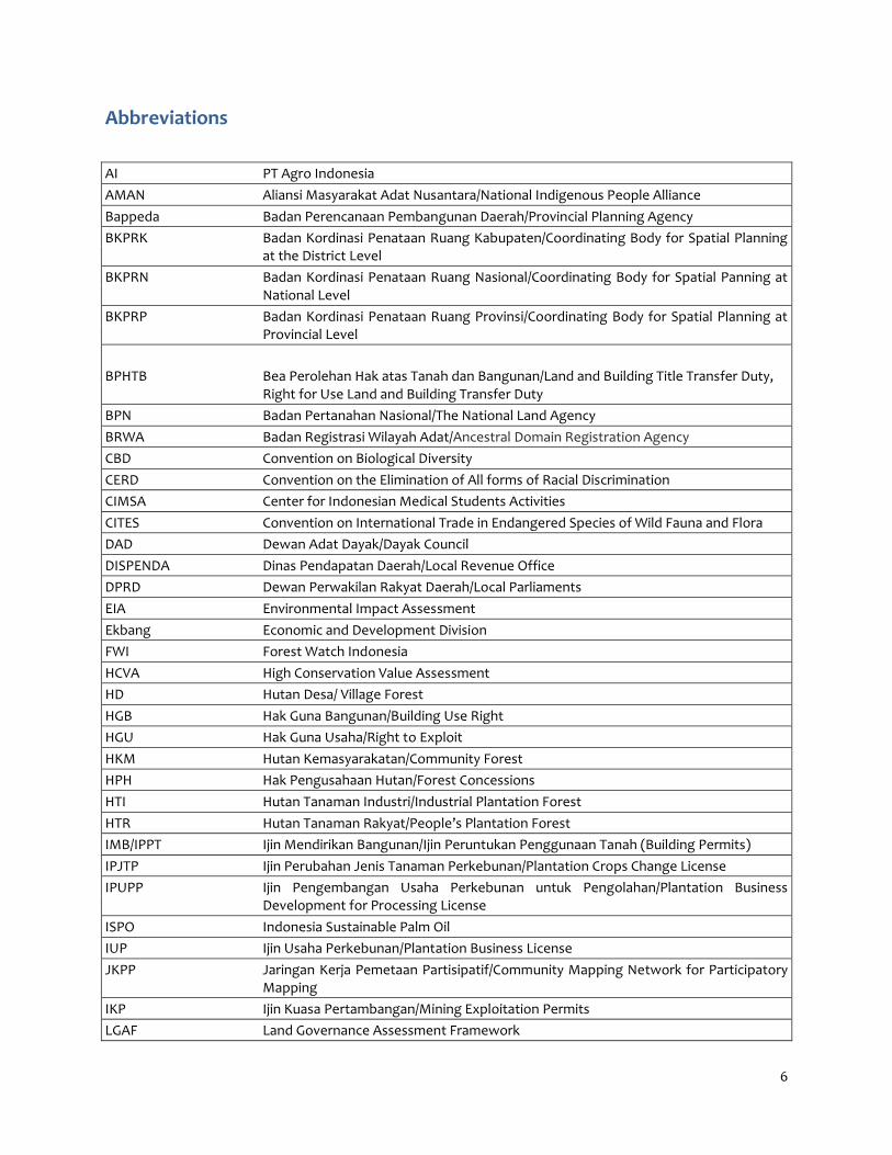
Abbreviations ............................................................................................................................................... 6
1. Introduction .............................................................................................................................................. 9
2. Methodology ........................................................................................................................................... 11
3. Central Kalimantan’s land management in the decentralization era ................................................... 13
3.1. Customary Land Tenure .................................................................................................................. 14
3.2. Incomplete Spatial Planning Process .............................................................................................. 15
3.4. Tenure Typology .............................................................................................................................. 17
3.5. Institutions related to Land ............................................................................................................. 21
3.6. Current Initiatives ........................................................................................................................... 22
4. Assessments ........................................................................................................................................... 23
4.1. Rural Land Use and Land Policy ...................................................................................................... 23
4.2. Rights to Forest and Common Lands & Rural Land Use Regulations .......................................... 35
4.3. Public Land Management ............................................................................................................... 43
4.4. Transfer of Large Tracts of Land to Private Investors .................................................................. 54
4.5. Public Provision of Land Information: Registry and Cadastre ...................................................... 63
4.6. Land Valuation and Taxation .......................................................................................................... 75
4.7. Dispute Resolution .......................................................................................................................... 80
5. Overall Score Card .................................................................................................................................. 85
6. Policy Recommendations ...................................................................................................................... 89
6.1. Land tenure recognition ................................................................................................................. 89
6.2. Rights to forest and common lands and rural land use regulations ............................................ 90
6.3. Public land management ................................................................................................................ 91
6.4. Transfer of Large Tracts of Land to Private Investors .................................................................. 92
6.5. Public provision of land information: registry and cadastre ........................................................ 93
6.6. Land valuation and taxation .......................................................................................................... 93

3
6.7. Dispute resolution ........................................................................................................................... 94
7. Conclusion .............................................................................................................................................. 95
7.1. Methodological Lessons.................................................................... Error! Bookmark not defined.
7.2 Lessons for Sub-National LGAF ......................................................... Error! Bookmark not defined.
List of References ...................................................................................................................................... 96
Annex 1 Policy Matrix ................................................................................................................................ 102

4
Executive Summary This report contains the results of a land governance assessment in Central Kalimantan that was carried out from December 2013 to July 2014. The World Bank developed the Land Governance Assessment Framework (LGAF) instrument and its partners to assess the status of land governance using a pre-coded framework of key land governance indicators based on global experience, using a participatory process that systematically draws on existing evidence. The LGAF is normally applied first at the country level. The assessment was done in three steps. The first step was analysing the consistency of terms and applicability of LGAF framework to the provincial context of Central Kalimantan. Then followed by the assessing the nine panels by using data from the secondary sources. This step was carried out by five expert investigators including local experts from Central Kalimantan. The next step was having a panel expert discussion where each panel experts was challenged to confront the data and the score judgement made by the expert investigators. The discussion was also aimed to facilitate the different views of panel experts on several matters. Panel experts were composed by the representative of relevant government agencies, NGOs, private sectors and indigenous peoples organization (AMAN). The inputs and comments from panel experts were consolidated by expert investigators and finally presented before the Provincial Secretary of Central Kalimantan in final policy dialogue for the whole stakeholder representatives, including government agencies, NGOs, indigenous peoples, and private sectors. Provincial Secretary attended and opened the dialog of LGAF on behalf of Governor of Central Kalimantan Province. This version was the last version that already incorporates the input from policy dialogue. Overall the finding of the this assessment are that land governance in Central Kalimantan is unsatisfactory. There is no satisfactory score (A) that can be assigned in any of the dimensions assessed in this study. Two major issues contraining good land governance in Central Kalimantan are: 1) the incomplete spatial planning process; and (2) difficulties in solving overlapping claims within state forests. Due to these problems, many dimensions have been scored poorly. Some other points that contribute to weakening the score are: (1) the indigenous claims have not been addressed properly; (2) weakness of positive and progressive initiatives to improve the system to administer land and serve the citizens efficiently; and (3) the problem of miscoordination of policies and programs between the province and districts. For example, the recognition of indigenous peoples rights that is designed by the Provincial Government has not been responded to well by the District Government. To address these problems, the Central Kalimantan Government should carry out the following actions:
Establish strong institutional support to accelerate the recognition of rights at the provincial level and collaborate with district institutions. A clear roadmap regarding output, timeline and supporting budget should be designed in a participatory manner that includes District governments as the main actor.
Necessary requirements should be developed for better recognition of community rights to forests based on Constitutional Court Decision No. 35/2012. Provincial and district governments should further develop the implementation of Governor’s Regulation No. 13/2009 to incorporate the Constitutional Court decision, especially to identify customary claims to forest land.
Developing or strengthening a monitoring tool to monitor the performance of district government agencies and license holders in dealing with environmental protection and communal/individual rights. The tool should be endorsed by cross-sector actors.
Establish a strong database regarding land rights, forest status and any types of use and function and update the database regularly. The data should be opened for public
For the national government, the following actions should be done:
The National Land Agency should accelerate the process of delineating boundaries for individual and communal rights. The process can be expedited by developing operational guidelines that are agreed by ministries especially the two main ministries, the Ministry of Forestry and the Land Agency.

5
Issue a regulation higher than a Ministerial Decree to recognize communities’ and individuals’ rights on forests and lands, such as through a government regulation. This will ensure that the initiative to recognize rights within state claims should go beyond a ministerial initiative and should be an inter-governmental collaboration.
A joint decree should be established by the Ministry of Forestry, the National Land Agency and the Ministry of Internal Affairs to make sure reference data and concrete guidelines, including specific steps and a list of involved institutions, will serve as a reference for relevant agencies at the provincial and district levels in managing state land and as a reference for data.
There are also some positive developments, especially related to public access to information. The Provincial Government has established an information commission and appointed a special officer to disclose public information including on land and natural resources. However, the information on land, such as individual and communal land, is still scattered across different agencies. It is difficult for common citizens to access information. Even the information commission has difficulties in getting the necessary information required to deal with requests for information on conflicted individual lands. Internet users can only access the information system on public land. Rural people have issues accessing the system. To improve land information management, a sufficient budget should be allocated to support the information commission. The capacity of local bureaucrats must also be increased. But the most important challenge is to make the bureaucrats aware that access to public information is a right of people/citizens. Several government officers continue to maintain the secrecy of information on the premise that a layperson does not have the right to know the information. In spite of the current challenges, Central Kalimantan is an interesting sub-national case study for decentralised land governance in Indonesia for a number of reasons:
Central Kalimantan is one of the pioneers in developing regulations and policies related to the recognition of adat (customary) community rights.
Central Kalimantan is one of four provinces that has not completed the provincial spatial planning process.
Since it was nominated as a REDD+ pilot province, several initiatives have been implemented to improve land management in Central Kalimantan in order to achieve the target to reduce emissions at the provincial level.
Large-scale investments in Central Kalimantan have led to serious problems in terms of land governance. In Central Kalimantan, a total of 1.3 million hectares has been allocated for plantations in the province. In the mining sector, around 3.7 million hectares have been allocated for mining concessions (at various stages in the permit process) out of 10 million hectares of forest area.
With respect to recognition of rights, in Central Kalimantan, the majority of lands are customary owned. Hence, the issue of customary land rights has become the major concern of decision-makers in Central Kalimantan.
6
Abbreviations
AI PT Agro Indonesia
AMAN Aliansi Masyarakat Adat Nusantara/National Indigenous People Alliance
Bappeda Badan Perencanaan Pembangunan Daerah/Provincial Planning Agency
BKPRK Badan Kordinasi Penataan Ruang Kabupaten/Coordinating Body for Spatial Planning at the District Level
BKPRN Badan Kordinasi Penataan Ruang Nasional/Coordinating Body for Spatial Panning at National Level
BKPRP Badan Kordinasi Penataan Ruang Provinsi/Coordinating Body for Spatial Planning at Provincial Level
BPHTB Bea Perolehan Hak atas Tanah dan Bangunan/Land and Building Title Transfer Duty, Right for Use Land and Building Transfer Duty
BPN Badan Pertanahan Nasional/The National Land Agency
BRWA Badan Registrasi Wilayah Adat/Ancestral Domain Registration Agency
CBD Convention on Biological Diversity
CERD Convention on the Elimination of All forms of Racial Discrimination
CIMSA Center for Indonesian Medical Students Activities
CITES Convention on International Trade in Endangered Species of Wild Fauna and Flora
DAD Dewan Adat Dayak/Dayak Council
DISPENDA Dinas Pendapatan Daerah/Local Revenue Office
DPRD Dewan Perwakilan Rakyat Daerah/Local Parliaments
EIA Environmental Impact Assessment
Ekbang Economic and Development Division
FWI Forest Watch Indonesia
HCVA High Conservation Value Assessment
HD Hutan Desa/ Village Forest
HGB Hak Guna Bangunan/Building Use Right
HGU Hak Guna Usaha/Right to Exploit
HKM Hutan Kemasyarakatan/Community Forest
HPH Hak Pengusahaan Hutan/Forest Concessions
HTI Hutan Tanaman Industri/Industrial Plantation Forest
HTR Hutan Tanaman Rakyat/People’s Plantation Forest
IMB/IPPT Ijin Mendirikan Bangunan/Ijin Peruntukan Penggunaan Tanah (Building Permits)
IPJTP Ijin Perubahan Jenis Tanaman Perkebunan/Plantation Crops Change License
IPUPP Ijin Pengembangan Usaha Perkebunan untuk Pengolahan/Plantation Business Development for Processing License
ISPO Indonesia Sustainable Palm Oil
IUP Ijin Usaha Perkebunan/Plantation Business License
JKPP Jaringan Kerja Pemetaan Partisipatif/Community Mapping Network for Participatory Mapping
IKP Ijin Kuasa Pertambangan/Mining Exploitation Permits
LGAF Land Governance Assessment Framework

7
LGI Land Governance Indicator
LOC Land Office Computerization (Spanish Government)
MK Mahkamah Konstitusi/Constitutional Court
MoA Ministry of Agriculture
MoE Ministry of Environment
MoF Ministry of Forestry
NJKP Nilai Jual Kena Pajak/Taxable Selling Price
NJOP Nilai Jual Objek Pajak/Sales Value of Tax Object
PBB Pajak Bumi dan Bangunan/Land and Building Tax
PHPL Pengelolaan Hutan Produksi Lestari/Sustainable Production Forest Management
POKKER SHK Kelompok Kerja Sistem Hutan Kerakyatan - Local NGO
PPAT Pejabat Pembuat Akta Tanah/Land Deed Officer
PPh Pajak Penghasilan/Income Tax
PRONA Proyek Operasi Nasional Agraria/Natural Scheme to Certify Rural Lands
PUP Penilaian Usaha Perkebunan/Plantation Performance Assessment
PUU Perundanga-undangan/Regulations
RAD-GRK Rencana Aksi Daerah Penurunan Emisi Gas Rumah Kaca/ Local Action Plan to Reduce Green House Gas Emission
RE Restorasi Ekosistem/Ecosystem Restoration
REDD Reduce Emissions from Deforestation and Forest Degradation
RPJMDes Rencana Pembangunan Jangka Menengah Desa/Medium Term Village Development Plan
RTRWK Rencana Tata Ruang Kabupaten/District and Regency Spatial Plan
RTRWP Rencana Tata Ruang Provinsi/Provincial Spatial Plan
SHM Sertifikat Hak Milik/Land Ownership Certificate
SIPUHH Sistem Penatausahaan Hasil Hutan/Forest Administration, Verification and Reporting System
SK Surat Keputusan/State Decree
SKPT Surat Keterangan Pendaftaran Tanah/Land Registry Record
SKT Surat Keterangan Tanah/Letter of Land Ownership
SKTA Surat Keterangan Tanah Adat/Customary Land Statement Letter
SOP Standard Operational Procedure
SPPT Surat Pemberitahuan Pajak Terhutang/Notification of Tax Due
SPT Surat Pemberitahuan/Tax Return
STD-B Surat Tanda Daftar Usaha Perkebunan/Cultivation Registration Certificate
STD-PJTP Surat Tanda Daftar Perubahan Jenis Tanaman Perkebunan/Plantation Crops Change Registration Certificate
STD-PUPHP Surat Tanda Daftar Pengembangan Usaha Pengolahan Hasil Perkebunan/Plantation Crops Processing Business Development Registration Certificate
SVLK Sistem Verifikasi Legalitas Kayu/Timber Legal Assurance System
TGHK Tata Guna Hutan Kesepakatan/Agreement on Forest Functions
UKP4 Unit Kerja Presidenbidang Pengawasan Pengendalian Pembangunan/Presidential Unit for Development Monitoring and Oversight
UNDRIP United Nations Declaration on the Rights of Indigenous People
UPT Unit Permukiman Transmigrasi/Units of Transmigration Settlement

8
UUPA/BAL Undang Undang Pokok Agraria/Basic Agrarian Law
WALHI Wahana Lingkungan Hidup Indonesia / Friend of the Earth Indonesia
WIUP Wilayah Ijin Usaha Pertambangan/Mining Permits Region

9
1. Introduction
Due to the increasing scarcity of land, good land management is crucial to sustain socio-economic development.
To improve land management policies and practices, a comprehensive assessment of land management is important. In this respect, the World Bank has produced a tool for assessment, called the Land Governance Assessment Framework (LGAF). The LGAF is a diagnostic tool to help evaluate the legal framework, policies and practice of land management and to monitor its improvement from time to time. Indonesia has made use of this tool.
In 2009, the LGAF was used in Indonesia for assessment at the national level. There are many lessons to be learned from the assessment. For example, the land control data used at the time were still based on the earlier Ministry of Forestry claim that 70 percent of Indonesia’s total land surface was zoned as state forest. Recently, however, there was a significant change in the definition of state forests. In May 2013, Indonesia’s Constitutional Court issued Decision No. 35/2012, declaring that hutan adat (customary forest) is no longer part of the state forest area. Instead, the ruling states that masyarakat hukum adat (customary law communities) have the right to manage their customary forests. This will have a great impact on the total forest area that falls under state control and the accuracy of the Ministry of Forestry claim that 70 percent of the country’s land is zoned as state forest. In addition, changes in the policies, practices and legal framework at regional level have taken place very quickly during the past few years. New issues and initiatives such as the insistence on recognition of adat community rights, efforts to settle and resolve land conflicts, and REDD+ have developed in such a way over the past three years that they have an impact on the composition and character of the law and policies.
Decentralization has led to a new interpretation of regional authority. Numerous regions have issued policies that are inconsistent with regulations at the national level. At the same time, only a few national regulations have been developed to accommodate the progressive dynamics of land management at the regional level.
This report focuses on the province of Central Kalimantan, where land is an increasingly scarce resource.
Two major issues in Central Kalimantan’s land management are unsolved customary claims on lands and the incomplete provincial spatial planning process. The government receives most of the contested land claims from indigenous people (REDD+ Task Force, Sekala, and Central Kalimantan Provincial Government, 2013). However, district heads primarily grant licenses by merely following the requirements of formal laws (Affif et al., 2011), therefore, social conflicts are prevalent. The major causes of these conflicts are unclear land boundaries and the unclear status of land. The incomplete provincial spatial planning process has created uncertainties regarding the classification of lands as forest or non-forest, which underpins the land tenure system in Indonesia. Each of these two major issues will be discussed below, followed by an overview of the land tenure typology in Central Kalimantan.
The Provincial Government has claims that of 1,530 villages in Central Kalimantan, about 600 villages could be categorized as “indigenous”.1 2 This claim needs to be clarified on the ground. Currently, the Provincial Government is struggling with the identification process of indigenous territories. Overall, in Indonesia recognition of land rights needs to take into account the Forestry Law, which applies to the larger part of the total land area
The Earth Innovation Institute, financed by the World Bank, has conducted this subnational land governance assessment in Central Kalimantan. This assessment is the first subnational assessment in Indonesia. A careful
1Statement of Provincial Secretary of Central Kalimantan, Dr. SiunJarias, in Public Dialogue early February of 2012. See Forest Peoples Programme, Pusaka and YayasanPetakDanum, 2011, Seri briefing hak-hak, hutandaniklim – Oktober 2011. 2 Various studies indicate that customary land tenure in Central Kalimantan follows the watersheds or the river system (DAS) (Usop, 2012: pg 47-64). For example, the Ot Danum tribe lives in the upstream area of the Kahayan, Katingan and Rungan rivers. The Dayak Ngaju generally lives downstream of Kahayan, Katingan and Barito rivers; while the greater part of Maayan and Lawangan lives west of Barito River.

10
examination of the decentralization process in land and natural resource management in Indonesia was carried out as part of the assessment. A full portrait of land management in decentralized Indonesia cannot be represented by Central Kalimantan alone; however, it is expected to offer an interesting case for a number of reasons:
Central Kalimantan is one of the pioneers in developing regulations and policies related to the recognition of adat (customary) community rights. Since the start of reforms in 1998, Central Kalimantan has drawn up a number of regional regulations on adat institutions that acknowledge the role of adat judiciaries in the settlement of conflicts
Central Kalimantan is one of four provinces that has not completed the provincial spatial planning process. Two contradicting regulations currently exist determining land-use allocation in Central Kalimantan, namely Provincial Regulation No. 8/2003 and Minister of Forestry Decree No. 292/2011.
Large-scale investments in Central Kalimantan have led to serious problems in terms of land governance. In Central Kalimantan, a total of 1.3 million hectares have been licensed out for plantations in the province. In the mining sector, around 3.7 million hectares have been allocated for mining concessions (at different stages of the permit process).
Central Kalimantan was appointed as a REDD+ pilot province in the context of cooperation (Letter of Intent) between Indonesia and Norway. Since then, several initiatives have been implemented to jointly improve land management in Central Kalimantan in order to achieve the target of emissions reductions at the provincial-level as well as on the national scale.
This report presents the results of the land governance assessment in Central Kalimantan. First, this report summarizes the methodology used to carry out the assessment. Second, it provides detailed information regarding the context of land management in Indonesia and specifically in Central Kalimantan. Third, the score and assessment results for each dimension are discussed, before the recommendations are provided.

11
2. Methodology Through good governance, the State can ensure that lands are managed for the improvement of people's welfare. The World Bank (2007, pg. 67) defines “governance” as “the manner in which public officials and institutions acquire and exercise the authority to shape public policy and provide public goods and services”. Good land governance is thus defined as (World Bank, 2012, pg. 28):
A legal, institutional, and policy framework that recognizes existing rights, enforces them at low cost, and allows users to exercise them in line with their aspirations and in a way that benefits society as a whole.
Arrangements for land use planning and taxation that avoid negative externalities and support effective decentralization.
Clear identification of state land and its management in a way that cost-effectively provides public goods; use of expropriation only as a last resort and only for direct public purposes with quick payment of fair compensation and effective mechanisms for appeal; and mechanisms for divestiture of state lands that are transparent and maximize public revenue.
Public provision of land information in a way that is broadly accessible, comprehensive, reliable, current, and cost-effective in the long run.
Accessible mechanisms to authoritatively resolve disputes and manage conflict, with clearly defined mandates and low cost of operation.
The tool used to conduct this assessment is the Land Governance Assessment Framework (LGAF) (see Deininger et al. 2011 and presented in a LGAF Manual (World Bank, 2013). The LGAF is a diagnostic tool to assess the status of land governance at the country level using a highly participatory and country-driven process. The assessment draws systematically on local expertise and existing evidence rather than on outsiders.
The assessment in Central Kalimantan was carried out between December 2013 and July 2014 Following a request by the governor of Central Kalimantan who is concerned over the growing number of land conflicts, the recognition of customary land rights to ensure that people will indeed benefit from investmenst in palm oil, and properly compensated in the mining sector. As the assessment is tailored to address local needs, it was decided in the meeting with the governor of Central Kalimantan on the 29th November that the study will focus on eight (8) thematic areas:3
1. Panel 1: land tenure recognition 2. Panel 2: rights to forest and common lands & rural land use regulations 3. Panel 4: public land management 4. Panel 5: transfer of large tracts of land to private investors 5. Panel 6: public provision of land information: registry and cadastre 6. Panel 7: land valuation and taxation 7. Panel 8: dispute resolution 8. Panel 9: review of institutional arrangements and policies
The LGAF process is guided by a framework of land governance indicators that cover these thematic areas and relates to a basic principle of governance based on international experience. The assessment in Central Kalimantan focused on 22 “land governance indicators” (LGI). Each indicator is further broken down into a number of “dimensions” with pre-coded statements that draw on global experience (on a scale from A to D). A total of 92 dimensions were assessed for the assessment in Central Kalimantan. Panel 6 on Urban Land Use has been included in panel 1 and 2 as they are substantively complementary.
3The exclusion of the Urban Land Use Panel was also agreed upon in the discussions with the World Bank team on 24th of September 2013 and 11th of October 2013.

12
The LGAF hierarchy of thematic areas, indicators and dimensions is represented in Table 1. A detailed version of the Framework that also sets out the four possible rankings or assessments for each dimension is presented in Chapter 5.
Five expert investigators were involved in assessing nine panels. Expert investigators were assigned to manage panels of local experts from Central Kalimantan. Some panels were led by local experts to ensure local specific situations are taken into account. The assigned tasks for each of the experts are detailed in Table 1.
Table 1 Assigned tasks to the expert investigators
No Theme Panel Expert
1 Land Rights Recognition, Rural Land Use
Panel 1: land tenure recognition Panel 2: rights to forest and common lands
& rural land use regulations
Dr. Sidik Rahman Usop
2 Public Land Management, Land Valuation and Taxation
Panel 4: public land management Panel 7: land valuation and taxation
Tristam Pascal Moeliono, PhD
3 Transfer of Large Tracts of Land to Private Sectors
Panel 5: transfer of large tracts of land to private investors
Dr. Iman Santoso
4 Public Provision of Land Information
Panel 6: public provision of land information: registry and cadastre
Alma Adventa, PhD
5 Dispute Resolution and Institutional Arrangement
Panel 8: dispute resolution Panel 9: review of institutional
arrangements and policies
Usep Setiawan S.Sos, Msi
The Experts first sourced data from numerous government and non-government institutions when carrying out their assessment and developed background papers.
As guided by the LGAF manual, panel discussions were carried out between 11 and 18 March 2014. In each panel meeting, at least five to seven panel members were invited. The background papers were then discussed and verified in the meetings. The flow of the discussion is presented in (Figure 1): During the discussion, sometimes each participant had a different opinion about the assigned score for a specific dimension and score sometimes ended up in different position. In these cases, the expert panel made the final decision. For several dimensions, scores could not be assigned for two main reasons. First, some dimensions cannot be contextualized for Central Kalimantan and need to be assessed either at the national level or in other provinces. Second, the four pre-coded statements used in the governance assessment (on a scale from A to D) that panelists needed to choose from where sometimes confusing. Therefore, the experts and panel members could not decide on those scores.
Figure 1. Discussion flow of panel meetings

13
3. Central Kalimantan’s land management in the decentralization era In Indonesia, Article 33 of the 1945 Constitution provides the State with the rights to control land, water and natural resources for the welfare of its people. The Constitutional Court further interprets the rights of the State in land management as follows: the State does not own lands; however, it has the authority to regulate, provide land tenure security for the people, manage and oversee lands for the welfare of the people.4
At the central level, there are at least 11 ministries as well as agencies involved in land management.5 Meanwhile,
in the regions, at the provincial-level as well as the kabupaten (districts), local governments also hold authority on land. The numerous authorities over land and extraordinary number of institutions handling the land issue have resulted in very complicated land arrangements, often in contradiction with one another. 3.1 History of land and forest law in Indonesia
Since the reforms of 1998, the Government of Indonesia has developed several strategy policies regarding the reform of the administration and land management. However, dualism in the land sector has become a major constraint in good land management. Conflicts occur as customary land laws contradict with the formal land law. For instance, many customary laws only acknowledge land relinquishment for “use” purposes, while the “connection/ownership” to the land is still maintained. On the other hand, according to the formal law, land relinquishment results in the termination of any kind of relationship with the land. The new ruling of the Constitutional Court No. 35/2012 on customary land has now instructed that all customary lands to be excluded from the state forests. This ruling provides opportunities for the acknowledgement of customary rights, which has been long ignored.
A sectoral approach segregates land administration and management into forest and non-forest areas. The Ministry of Forestry is responsible to manage state forest lands according to the basic Forestry Law of 1999. The Ministry of Forestry controls over 130 million hectares of forest lands that constitutes about 70 percent of Indonesia’s territory. The land agency, working in conjunction with local governments, deals with land management of areas outside state forests that can be allocated for agriculture, mining, housing, and infrastructure. Different ministries are responsible separately for different sectors. 3.2 Central Kalimantan
Indonesia is administratively divided into provinces, districts and municipalities. The constitution defines three of them as local government. Law No. 32/2004 on Regional Autonomy continuously builds on the constitution by providing concrete legal definitions for the form and scope of authority of local governments. For example, the province is authorized to coordinate development planning and spatial planning as a reference for districts and municipalities to set up their own development and spatial plans. A detailed division of authorities is further elaborated in Government Regulation No. 38/2007. Principally, the provincial government’s role is to coordinate and supervise district and municipality governments.
Central Kalimantan is one of five provinces in Indonesian Borneo (Kalimantan). The province consists of 13 districts and one municipality. The total population of Central Kalimantan is 2.2 million according to the 2010 census. Besides providing a portrait of population density, the census also elaborated on the composition of ethnic groups in Central Kalimantan. Based on census data, the ethnic composition of Central Kalimantan population is: Dayak (54.28%), Banjar (24.20%), Javanese (18.06%) and Madurese (3.46%). The Dayak ethnicity is comprised of four major sub-tribes, namely the Dayak Ngaju, Dayak Lawangan, Dayak Ma’ayan and Dayak Ot-
4 Judicial Review of Law No. 18/2004 5 The eleven ministries and agencies are: the Ministry of Domestic Affairs, the Ministry of Energy and Mineral Resources, the Ministry of Agriculture, the Ministry of Forestry, the Ministry of Manpower and Transmigration, the Ministry of Public Works, the Ministry of Under-Developed Regions, the Ministry of State-Owned Enterprises, the Ministry of National Development Planning/the Agency of National Planning, the Ministry of People’s Housing and the National Land Agency.

14
Danum. The Dayak majority in Central Kalimantan is in the fact occupying the large number of customary claim on land in Central Kalimantan.
Some of villages in Central Kalimantan are still isolated with limited exposure to outsiders. These areas have little intervention from national laws. Despite the State’s unilateral formal claim on lands, indigenous claims on lands are typically more accepted locally than land transactions under formal laws. Business entities are familiar with land transactions based on customary laws. Non-formal documents such as Surat Keterangan Tanah (Letter of Land Ownership) or Surat Pernyataan Tanah (Statement Letter of Land Ownership) are often used as the evidence of land ownership, rather than certificates issued under the National Agrarian Law. Land transactions based on customary laws can be accepted publicly.
3.1. Customary Land Tenure in Central Kalimantan
Like many places in Indonesia, the complexity of contested claims on lands among different actors shapes land tenure in Central Kalimantan. Four categories of land claims, based on the actors involved, include private or individual, communal, open access and state claims. These categories, however, are not clearly established with agreed-upon and well-definied boundaries. The Ministry of Forestry recognizes that thousands of villages overlap with state forest (Daryanto, 2011). Communal claims by indigenous peoples can also occur on state land (Kemitraan, 2010).
Field facts indicate that customary land rights claims, including in forest areas, are reasonably strong. The Provincial Government claimed that of 1,530 villages in Central Kalimantan, about 600 villages could be categorized as “indigenous”.6 Various studies indicate that customary land tenure in Central Kalimantan follows the watersheds or the river system (DAS) (Usop, 2012: pg 47-64). For example, the Ot Danum tribe lives upstream of Kahayan, Katingan and Rungan rivers. The Dayak Ngaju generally lives downstream of Kahayan, Katingan and Barito rivers; while the greater part of Maayan and Lawangan lives west of the Barito river.
The State recently recognized customary rights on land pursuant to the Constitutional Court Decision No. 35/2012 (MK 35). In practice, however, the recognition of customary claims on forests is not straightforward. In response to Constitutional Court Decision No. 35/2012, the Ministry of Forestry issued Decree P.62/Menhut-II/2013 to provide space for recognition of customary forests. However, to implement such a decision, information collection (through a mapping process) to deterimine the locations of customary lands is required. These maps should later be endorsed by local authorities, in this case the district heads. The mapping process of customary lands should be facilitated to ensure that local communities are not in a losing position when dealing with land speculators. This Decree complicates the process of recognizing customary forests, by adding additional procedures to those outlined in the Constitutional Court Decision MK 35 or in the Constitution. The procedures stipulated in the Decree are not aligned with the Forestry Law, which is the underpinning regulation for forest management in Indonesia.
In Central Kalimantan, provincial and district regulations recognize the rights of Indigenous Dayak communities. Prior to decentralization, Provincial Regulation No. 14/1998 provided a legal basis for Dayak Customary Institutions. Numerous regulations at the district level were then issued, including Barito Selatan District Regulation No. 17/2000, Kapuas District Regulation No. 5/2001, and Kotawaringin Timur District Regulation No. 15/2001. Furthermore, Provincial Regulation No. 16/2008 provided a legal basis for the customary rights on lands. This Regulation was further detailed by Governor’s Regulation No. 13/2009, which provided more specific arrangements on land via the land registration process under the authority of customary institutions such as Damang and Mantir. Governor’s Regulation No. 13/2009 classifies customary land tenure into:
a. Customary land owned or controlled jointly by a customary group. The subjects are the heirs; b. Customary land owned by an individual. The subjects are individuals; c. Customary rights on lands owned by heirs or individuals. The subjects are the heirs or individuals.
6 Statement of Provincial Secretary of Central Kalimantan, Dr. Siun Jarias, in Public Dialogue early February of 2012. See Forest Peoples Programme, Pusaka and Yayasan Petak Danum, 2011, Seri briefing hak-hak, hutan dan iklim – Oktober 2011.

15
In reality, customary rights on land in Central Kalimantan are more complex than those stipulated by Governor’s Regulation No. 13/2009. Galudra et al. (2010) provide a more detailed description regarding the structure of adat tenure in Central Kalimantan, including:
1. Eka Malan Manan Satiar is a right for a local community to hunt animals, open the forest for cultivation, and collect non-timber forest product such as damar, gemor, jelutung, rattan, and panting. The area, designated as land used by the community, typically covered five kilometers around the community settlement.
2. Kaleka is an ancient adat community settlement that had been abandoned and returned to secondary forest. The area was considered a sacred area and determined as having communal adat land rights.
3. Petak Bahu is an ex-swidden area that has become (agro)forest, mostly planted with durian, cempedak, rubber and rattan, along with natural forest regeneration. Only the previous cultivator, based on hakter dahulu (previous right holder), could use and collect the forest products.
4. Pahewan/tajahan and sepan are sacred forest areas, where the local community had rights and obligations to protect the areas from any land use activity.
5. Beje is a fish pond made by the local community to trap and store fish during the dry season. The pond may be owned either privately or communally.
6. Handil is the right of a local community to construct small drains to open up land for shifting cultivation. The work is usually organized around a group, with each member of the group receiving two hectares of land alongside the small drainage banks. Ownership was considered communal.
Theoretically, the Governor’s Regulation is already flexible enough to accommodate the complexities of adat tenure claims in Central Kalimantan by categorizing customary land titles into three main titles: communal, individual and hybrid (Article 8). However, the classification of the remaining indigenous rights remains unclear. Some organisations representing indigenous peoples, such as AMAN (National Indigenous People Alliance), do not agree with the incorporation of individual rights as a part of customary rights. AMAN7 believes that communal rights are the only claims that should be considered as indigenous claims in Central Kalimantan. Another challenge in the recognition of customary land rights is to identify the locations and total land areas of the customary claims of indigenous people.
The Governor’s Regulation on customary rights cannot be applied in state forests. The Ministry of Forestry currently has the authority to control areas classified as state forests.
According to the Constitutional Court Decision No. 35/2012, indigenous claims should not be limited by licenses that have been issued previously within state forest. The process of acknowledging indigenous claims should not be isolated, but it should be carried out together with the process of verifying how the existing rights/permits were allocated in the past. If evidence shows that the process in the past involved land grabbing, intimidation, bribery, and other illegal measures, it should create an opportunity to review or negotiate the rights/permits. Therefore, facilitate the acknowledgement of indigenous claims on lands, the process should not be based solely on the evidence that is provided by the indigenous peoples; the existing right/permit holders should provide evidence on how they obtained the lands as well. This is also a start to address the overlapping claims between land users in Central Kalimantan.
3.2. Incomplete Spatial Planning Process
The decentralization process that was started in 1999 devolved power to the district/municipality level, including in land and other natural resource management. Following the implementation of regional autonomy, there was a shift of authority from the central government (ministerial level) to local governments (including local offices – Dinas and Badan). The shift of authority from central to local government is legalized and strengthened through the enactment of local government legislation (Law No. 32/2004 on Regional Autonomy; Law No. 33/2004 and Government Regulation No. 55/2005 about Balancing Fund). Provisions about the division of authority between
7 As confirmed in the Panel Discussion held on 13 March 2014

16
the central government and local governments are further regulated and articulated in Government Regulation No. 38/2007 (incl. the division of government scope of work between central, provincial, and district governments). District/municipality governments are authorized to deliver mandates, including related to land use, development planning, environment, and land registry. Several optional mandates for local governments include agriculture, forestry, energy and mineral resource. The provincial/district governments are also obliged to implement numerous international conventions related to forestry, flora-fauna protection and conservation, and climate change, since the national government has ratified these conventions, including the Convention on Biological Diversity and the Convention on Climate Change.
Local governments are authorized to define land classifications and functions at the provincial and district level. Law No. 26/2007 on Spatial Planning stipulates that provincial and district governments should develop local spatial plans according to guidelines and norms established by the national government. Spatial plans, according to Law No. 26/2007, regulate the purpose of a specific zone. The various purposes include zones allocated for cultivation, protected areas, and zones allocated for infrastructure development. The Spatial Plan approach is a hierarchical and complementary system, which beings at the national level then continues down to provincial and district/municipality level. The National Plan is a long-term strategic plan with a time line of 25-50 years. Provincial plans (known as Rencana Tata Ruang Wilayah Provinsi or RTRWP) contain the operationalization strategy and define the policy direction of spatial use at the provincial level. RTRWP is a medium-term strategic plan with a period of 15 years. District and Municipality plans (RTRWK) are short-term operational plans with a time period of 5-10 years. Spatial plans can be revised every 5 years at all levels to adjust the function of an area in accordance with its physical condition.
The Provincial Spatial Plan in Central Kalimantan has not been completed. In 2003, Provincial Regulation No. 8/2003 was issued to provide a legal basis for the Provincial Spatial Plan in Central Kalimantan. The plan should, however, be endorsed by the National Government so that it can be legally enforced. One of the steps the National Government should have carried out to endorse the plan is to synchronize and harmonize the Proposed Spatial Plan with the National Spatial Plan. The National Spatial Planning Coordination Agency coordinates relevant ministries to review the proposed spatial plans.
Due to the persistent conflict between the Ministry of Forestry and the Provincial Government, the process of classifying areas as forest or non-forest zones has not been completed in Central Kalimantan. The initial classification of lands as either forest or non-forest areas has been conducted based on a process called TGHK (agreement on forest functions). The TGHK process involved desk studies that produced Forest Zone maps based on images from remote sensing. The process of TGHK was formalized through the issuance of Ministerial Decree No. 173/1986. In 1999, the TGHK was then synchronized with the Provincial Spatial Plan (RTRWP), through a process called Padu Serasi (harmonization). Padu Serasi aimed, as a result of the TGHK process, to reach a consensus on the locations of forest zones and non-forest zones, or areas for other uses (area penggunaan lain - APL), that were proposed in the RTRWP. In Central Kalimantan, TGHK was completed in 1982, which constituted an initial draft of forest classification. This should have been further confirmed through the Provincial Spatial Plan. However, the Spatial Plan of Central Kalimantan has not been agreed upon by the Ministry of Forestry (MoF) and the Provincial Government to date. Central Kalimantan has already passed Provincial Regulation No. 8/2003 on the Provincial Spatial Plan, which constitutes an agreement by “harmonious and integrated” [padu serasi] consensus at the provincial level. In 2011, the MoF through Decree No. 292/Menhut-II/2011, stipulated the area of the forest zone in Central Kalimantan to be 12.6 million hectares. In 2012, the MoF amended its previous decree and issued Decree No. 529/Menhut-II/2012, in which the area of the forest zone again changed to cover 12.7 million hectares. According to Article 15 of Law No. 41/1999, which is further interpreted by Forestry Ministerial Decree No. 44/2012 in conjunction with 62/2013, there are four stages that should be pursued to formalize the legal status of forest zones, namely indication, delineation, mapping and formalizing of the forest zone status. A major part of the forest zone in Central Kalimantan is still in the stage of indication.

17
The status of the forest zone in Central Kalimantan is currently unclear (Table 2). The Provincial Regulation No. 8/2003 and the Forest Ministerial Decree No. 292/2011 are in conflict due to two main problems:8
1. Over 1 million hectares are currently classified as productive areas under the Provincial Spatial Plan, while those areas are classified as protection or conservation areas by the Forest Ministerial Decree;
2. Less than 600,000 hectares are currently classified as productive areas by the Ministerial Decree but they are classified as protected or conservation areas by the Provincial Spatial Plan.
Table 2 forest areas in Central Kalimantan according to different regulations from 1982 to 2012
No Year Related Regulation (Product) on Forest Area
Total Provincial Area (mill. Ha)
Forest Area (%)
Total Forest Area (mill. Ha)
1 1982 Agreement of forest function (TGHK) 15.30 99 15.15
2 1993 Provincial Regulation No. 5/1993 on Provincial Spatial Plan (RTRWP)
15.37 72
11.06
3 1999 Harmonization Process of the Provincial Spatial Plan (RTRWP Padu Serasi)
15.80 66
10.43
4 2003 Provincial Regulation No. 8/2003 on Provincial Spatial Plan (RTRWP)
15.36 67
10.29
5 2007 Proposal for harmonization of spatial plan 2007 (Padu Serasi RTRWP 2007)
15.41 56
8.63
6 2011 Forest Ministerial Decree No. 292/2011 15.43 82 12.65
7 2012 Forest Ministerial Decree No. 529/2012 15.43 82 12.65 Source: Roadmap Central Kalimantan toward Low Emission Rural Development, 2013
3.4. Tenure Typology
The tenure typology can be developed based on the actors who have rights or claims over lands. There are at least four categories of actors that can claim land: private (i.e an individual, a married couple, a group of people, or a corporate body such as a commercial entity or non-profit organization), communal, open access, and state. Indonesian land tenure divides land into areas classified as state forest and those classified as non-state forest. The areas classified as state forests are controlled by the Ministry of Forestry, while the National Land Agency has authority to grant rights over lands classified as non-state forests.
Lands under the control of the Ministry of Forestry Forest land makes up the majority of the land area in Central Kalimantan Province. From 1982 to 2000, more than 90 percent of the provincial territory was allocated as forest land. From 2000, the negotiation to re-define the status of forest land has been carried out between the Provincial Government and the Ministry of Forestry. As a result, about 5 million hectares of land was proposed to be re-classified to be managed by Provincial Government and categorized as APL. However, the negotiation is ongoing and a clear political decision has not yet been reached.
The Forestry Law No. 41/1999 regulates the management of state forests. Two main categories within forest zones are: 1) permanent forest zones; and 2) conversion forest zones (areas that are/were under the control of the Ministry of Forestry and are/were relinquished for non-forest purposes). For the later category, there is a transfer of authority from the Ministry of Forestry to the National Land Agency.
8Roadmap Central Kalimantan toward Low Emission Rural Development, 2013

18
Within forest zones, three major typologies of tenure arrangements exist, namely: the status of the area, the function of the zone. and the degree of rights that apply. These categories determine the scope of tenure and at the same time the restrictions on forest resource utilisation, as follows:
1.The legal status is confirmed after going through four stages to formalize the legal status of the forest zone, namely indication, boundaries delineation, mapping and formalization.9 The forest function can be assigned after the legal status is formalized. A major part of the forest zone in Central Kalimantan is still in the indication stage. Moreover, since the Central Kalimantan Spatial Plan is not finalized, the forest zone status is still certain. This situation is complicated by the uncertainty created by the Constitutional Court Decisions No. 45/2011 and No. 35/2012. The Constitutional Court Decision MK 35 altered the control regime of the forest zone. Before, the adat community was considered to possess no rights to land in the forest zone. Currently, the claims of the adat community on forest areas should be recognised, according to the ruling by the Constitutional Court.
2. The major forest zone functions include production, protection and conservation, according to the Forestry Law No. 41/1999. The main function of production forests is to produce forest commodities, mainly timber and timber products. Some production forests are also classified as conversion forests, which can be legally converted to other non-forest land-use activities. Protection forests provide environmental services such as hydrological regulation, flood prevention, erosion control, avoidance of seawater intrusion, and maintenance of soil fertility. Conservation forests, which include national parks and nature reserves, are intended to conserve biodiversity. Legally, land use change from forests to non-forests can occur in areas classified as conversion forests and areas classified for other purposes (APL). According to the Forestry Law, conversion forests can be allocated for a number of non-forest purposes, including infrastructure and other land uses such as agriculture, tree crop plantations and mining.
3. The rights on the forest zones can range from mandates given to government agencies to permits granted to concession holders.10 First, mandates are given to government agencies, either central or local, to manage conservation forests as well as for the management of forest zones for special purposes. A second type of right that can apply in the management of Indonesian state forests is “transferred rights” which can be defined as partial rights transferred by governments to other parties to manage forest zones. In this case, the parties who are given the partial rights do not have to adhere to a prescribed silviculture system in managing the forest resources. As long as they do not change the function of the forests, the right is acknowledged and effective. This type of rights can be found in the case of village and customary forests. A village institution can be granted management rights before they can apply for specific permits from the local governments to utilize forest resources. Likewise, a customary community can be given rights to manage the forest based on their customary regulations and wisdoms. The third and most prominent type of rights that apply in the management of forest zones are “permits”. This type of rights can be defined as the use rights transferred to companies, groups of people, or individuals to utilize forest resources according to specific silviculture prescriptions embedded in the rights. The tenure arrangements within production and protection forests are based on permits. In the case of a village forest, unlike under a permit scenario, even if the village institution has been granted village forest management rights, a timber commercialization permit needs to/should be obtained by the village institution if they want to utilize the timber in the village forest.
Based on these categories, the tenure types within forest zones (both permanent and conversion areas) are summarized in Table 3. The data about the total area for each tenure type provided in Table 4 are preliminary figures. They have been verified during the LGAF study.
9Article 15 of Law No. 41/1999 10 Muttaqin, 2013, LAND AND FOREST MANAGEMENT IN INDONESIA: COMMUNITY ACCESS TO STATE FORESTS, Chapter 3 of PhD Thesis submitted to Australian National University

19
Table 3 Tenure types within forest zones
Tenure type Forest Zones and Allocations Total area
a. Forest zone with permits allocated to concession holders (private actors)
HPH (Natural Forest), HTI (Industrial Plantation Forest), HTR (People’s Plantation Forest) and RE (Ecosystem Restoration) cover 4,667,917 ha. Meanwhile the utilisation licences being processed cover 201,882 ha.
4,869,799 hectares
b. Forest zones used by non-adat community
The area of community forest [HKM] in Central Kalimantan in possession of a utilisation decree from the Ministry of Forestry as of November 2011 covers 3,590 ha. Meanwhile People’s Plantation Forest [HTR] covers 11,942 ha.11 A Minister of Forestry decree regarding licenses for Rural Forest [HD] was issued in 2012 for 4 villages with a total area of 16,245 ha. The respective area is (1) Kelurahan Kalawa 4,230 ha, (2) Desa Buntoi 7,025 ha, (3) Desa Mentaren I 1,835 ha, and (4) Desa Gohong 3,155 ha.12 The partnership scheme is not yet effective.
31,777 hectares
c. Forest zones under the government’s control
Based on the Ministry of Forestry’s report (2012), forest area that is allocated for conservation in Central Kalimantan is around 1.608.286 ha. For protected forest it is 1.630.828 ha.13
3,239,114 hectares
d. Permanent forest zones without permits/licenses
According to Ministry of Forestry data, the areas of production forests currently without licences are 4,847,653 ha.
4,847,653 hectares
e. Forest zone relinquished for mining and crop plantations
For estate crops and mining The area of forest zone allocated for estate crops from 2006-2011 and still at the approval in principle stage was 185,159 ha.14
The area of forest zone for estate crops from 2006-2011 at the stage of release from the forest zone was 652,326.53 ha.15
837,485.53 hectares
f. Forest zone relinquished for transmigration program
The forest zone area used for transmigration and still in the approval in principle stage from 2006-2012 covered 166,380 ha. This area comprises 101 transmigrant territory units.16
The forest zone area for transmigration that has reached the stage of a decree [SK] on the release of forest zone covered 134,505 ha for 56 territory units.17
From 1960 to 2011, 100,591 Family Heads or approximately 395,621 transmigrants have been placed in 261 transmigration settlements (UPT) in 14 kabupatens of Central Kalimantan.18 In November 2013, new transmigrants arrived in three districts namely Kabupaten Barito Timur, Gunung Mas and Kapuas. In Barito Timur 300 families arrived, comprising 150 families from the surrounding area and 150 families of new transmigrants originating from Lampung, West Java, and Central Java. In
300,885 hectares
11DirectorateManagement Territory and Preparation of Forest Utilisation Area, DirectorateGeneral Forestry PlanologyMinistry of Forestry, Jakarta, November 2011, Data and Informastion on Forest Utilisation of the year 2011, page. 25 12 http://berita.borneoclimate.info/2013/03/26/penyerahan-sk-kemenhut-tentang-hutan-desa/ 13DirektoratJenderalPlanologiKementerianKehutanan, 2013, StatistikBidangPlanologiKehutanan 2012, KementerianKehutanan, Pg. 7 14ibid, page 23 15page. 24 16 Kementerian Kehutanan Direktorat Jenderal Planologi Kehutanan, Juni 2012, Statistik Bidang Planologi Kehutanan 2011, Jakarta hal. 21 17 ibid hal. 22 18 Tempo, 12 Februari 2013. http://www.tempo.co/read/news/2013/02/12/173460900/Kalimantan-Tengah-Moratorium-Transmigrasi

20
Gunung Mas District 125 families, which included 65 families from the local area and 60 families of new transmigrants originating from Bali, West Java, and Lampung. Meanwhile in Kabupaten Kapuas 125 families arrived, comprised of 100 families local families and 25 families of new transmigrants .19
g. Forest zone claimed for customary groups In Central Kalimantan, it is recorded that 30,000 hectares of
forest areas have been claimed by indigenous people in two districts.20It is unclear whether these lands have been relinquished from the state forest zone or whether they are currently managed as customary forests.
30.000 hectares
Land under the Control of the National Land Agency The National Land Agency has the authority to grant rights over land, particularly to individuals and private entities. There are eight categories of rights that are given by the national land agency: (1) freehold title, (2) right to cultivate land, (3) building rights on land (4) right to use (5) right to rent, (6) land clearing rights, (7) right to collect forest products (8) and other rights that are not listed, which are are temporary. These rights are regulated by law. Another category is ulayat or adat land. It is mentioned in BAL and regulated in detail by Head of the National Land Agency Regulation No. 5/1999,
Table 4 summarizes different types of land tenure that are currently under the control of the National Land Agency. A detailed description about each type is provided below.
Table 4 Land under the control of the National Land Agency
Tenure type Total area
a. Free state land Data are not available
b. Non-free state land The area of state land on which licences have been issued is not yet clear either. The right to cultivate for plantation companies: 908,175 hectares (out of over 3 million hectares that have been given as permits, ranging from location permits to business permits)
c. Adat land There are no official data on the area of land controlled by the adat community. The data collected by the Adat Domain Registration Body (BRWA), mentions that the area mapped as adat domain in Central Kalimantan covers 139,153.48 ha in three districts alone namely Kapuas, Barito Selatan and Seruyan. The total size of land has likely increased since the mapping is still ongoing.
d. Abandoned land Abandoned land are areas that is not utilized by the rights holder for a certain period. The area of abandoned land in Central Kalimantan is not yet known. Various reports indicate that numerous HGU areas in Central Kalimantan are abandoned, however, the figures are varied. In February 2012, BPN records
19Tempo, 13 November 2013, see http://www.tempo.co/read/news/2013/11/13/058529397/Kalteng-Datangkan-235-Keluarga-Transmigran-Baru 20 BRWA was established pursuant to the Decree of the Central Board of Indigenous Peoples’ Alliance of the Archipelago
(Aliansi Masyarakat Adat Nusantara – AMAN), which at this early stage is in cooperation with the Indonesian Community Mapping Network for Participatory Mapping (JKPP) and Forest Watch Indonesia (FWI). The main tasks and functions of BRWA are: (1) to receive registration of ancestral domains; (2) to verify the data of registered ancestral domains; (3) to validate mapping methodology on ancestral domains; (4) to publish and announce ancestral domains, the map of the area and the profile of indigenous peoples; (5) provide information to support the process on the recognition and protection of indigenous peoples; and (6) provide information for spatial planning and indigenous territories.

21
showed that there were 7.3 million hectares of abandoned land throughout Indonesia.21 However, in September 2012, the National Land Bureau records stated that there were 149 thousand plots or approximately 4.8 million hectares of abandoned land throughout Indonesia.22 This figure is far below the total area of abandoned land in 2007, which was 12.4 million ha. Of this figure, 7.4 million ha was located in Kalimantan.23
e. Private land From 2000-2013 only 432,172 ha out of 5 million hectares non-forest land is certified. Most of the certified land was given to city residents. In rural areas, the certified land was typically given to those that live near plantation areas
3.5. Institutions Related to Land
The two major government institutions that are responsible for land management at the national level are the National Land Agency and the Ministry of Forestry. In Central Kalimantan, the total forest area ranges from 72 percent to 82 percent of the total land area in the province, according to figures based on different regulations. Regardless the areas that are currently under dispute, the majority of Central Kalimantan’s total land area is currently classified as state land; hence, it is under the management and control of the Ministry of Forestry. The remaining area (22 percent to 12 percent of the total land area) is classified as non-forest area. In these areas, the Land Agency has the authority to grant different types of rights to the land. Other institutions at the national level related to land management, especially the land use and control, are those that deal with the mining, plantation, environment and agriculture sectors. These related institutions are connected through coordination in the land use planning process.
Currently, the Central Kalimantan Provincial Government has several institutional initiatives to address the land-related problems. Two specific institutional initiatives are the conflict resolution initiative and efforts to activate the role of indigenous institutions such as Damang and Mantir to identify and tackle the indigenous claims to land. The conflict resolution mechanism has been established through Governor’s Decision No. 188.44/108/2012 concerning a mechanism to prevent, handle and resolve conflicts related to plantation businesses. Land conflicts and causes have been identified. Some recommendations are related to the role of the Central Government. For example the Ministry of Forestry’s claim to land does not allow the local government to entitle land parcels to forest communities. It becomes one of the main administrative barriers for land certainty in Central Kalimantan. Provincial Regulation No. 16/2008 and Governor’s Regulation No. 13/2009 have recognized the involvement of Damang and Mantir institutions in land-related issues. According to Governor’s Regulation No. 13/2009, a Customary Land Statement Letter (Surat Keterangan Tanah Adat or SKTA), as one of the requirement for land registration, should be issued by the Kedamangan (Head of indigenous people). In contrast, the Circular Letter of the Head of the National Land Agency No. 9/SE/VI/2013 stated that such a reference letter should be signed by the village head.
In addition to the Land Agency and the Ministry of Forestry, several other central government agencies have some power to claim land, such as agencies handling mining and infrastructure. Procedures to get land for mining and infrastructure are far less inclusive in terms of local participation compared to plantation and forest use licenses. It is very often the case that the mining agency acts according to its own rules and procedures. For the provincial and district governments in Central Kalimantan, this is a burden since past contested land issues in an area may not have been resolved, then suddenly these are challenged by new licenses demanded by the central government agencies.
21 http://industri.bisnis.com/read/20120207/99/63023/lahan-telantar-7-3-million-ha-bisa-dialokasikan-untuk-tanaman-pangan 22 http://www.tempo.co/read/news/2012/09/25/173431657/Pemerintah-Rugi-Miliaran-Akibat-Tanah-Terlantar 23 http://pustaka.litbang.deptan.go.id/publikasi/wr293072.pdf

22
Overall, contested authorities characterize the relationships between land-related institutions in Central Kalimantan. It is not clear yet what are the best approaches are to resolve the conflicting authorities. This rsults in a costly administrative process. This can be reflected by a businessman who faces unclear administrative procedures, making the process to get license very long and extremely expensive.24 In practice, there are also cases where a company has a license to operate but is rejected by the community because of a conflicting claim between a licensed area and an indigenous claim to land.
3.6. Current Initiatives
The Central Kalimantan Government has actively promoted a scheme to Reduce Emissions from Deforestation and Forest Degradation (REDD+) since 2010 to address environmental and social issues due to policies and practices related to land management. The Governor of Central Kalimantan signed a memorandum of understanding on REDD+, together with the President's Delivery Unit for Development Monitoring and Oversight, publicly known as UKP4. The scopes of works are as follows:
1. To develop and establish the institutions and processes to prepare Central Kalimantan for implementing REDD+ comprehensively;
2. To develop and improve the policies and regulations at the local level that are necessary to create a legal framework for REDD+ in Central Kalimantan;
3. To develop strategic activities in order to implement REDD+ comprehensively; 4. To ensure a paradigm shift and culture of work among all relevant stakeholders in Central Kalimantan to
make REDD+ a success; 5. To ensure the engagement of multi-stakeholders in planning, implementing and monitoring REDD+ The REDD+ initiative in Central Kalimantan has produced a single map, referred to as “one map,” that attempts to map all claims among various actors in the Province. Through this initiative, the Provincial Government aims to harmonizie and syncornize the overlapping and contradicting maps that have been refferred to by different ministries and government agencies. The REDD+ initiative has also led to the implementation of a moratorium policy, which aims to improve land governance through a temporary suspension of issuing new licenses on peatlands and primary forests. Kartodiharjo (2013) reported that some progress has been made as the policy could stop the expansion in peatlands and forests. However, Telapak and EIA (2013) have exposed evidence that one company, PT Menteng Jaya Sawit (MIS) in Kotawaringin Timur District was operating on land that was declared by the president as belonging to the moratorium area. To date, there is no legal action that has been taken regarding this violation.
24 Sharing information from business groups related to the procedures to get business use licenses in Central Kalimantan and South Kalimantan. The discussion was organized by UKP4 on 21 January 2014.

23
4. Land Governance Assessments Findings
4.1. Rural Land Use and Land Policy
Rural lands in Central Kalimantan are claimed mostly by adat/indigenous, state and private actors. Since the provincial spatial plan has not been finalized, numerous claims are currently overlapping and contradicting with each other. At the same time the claims from indigenous peoples cannot be addressed local regulations alone. The legal challenge for indigenous rights is rooted in national forestry legislation and unfair natural resources distribution which has existed historically since the colonial era. Policies in which the political preference for natural resources distribution favors granting more land for the rich and leaving smaller parcels for the poor are common practice all through Indonesia. Due to this problem, national laws, regulations and policies aiming to resolve land tenure issues cannot be implemented properly. Furthermore, the lack of institutional support prevents the efforts to formally recognize rural land tenure. The Land Agency considers the contested and conflicting claim to be business as usual, hence, no strategy has been put forward to solve the issue.
The assessment was carried out to trace the response of the government regarding the actual types of land tenures and how the policy could effectively address those tenure types.
Table 5 Panel 1 Land Tenure Recognition
Score
LGI Dim. LGAF INDICATORS AND DIMENSION A B C D
PANEL 1. LAND TENURE RECOGNITION
Land Governance Indicator (LGI) 1. Recognition of a continuum of rights: the law recognizes a range of rights by individuals (incl. secondary rights, rights by minorities and women)
1 1 INDIVIDIUAL RURAL LAND TENURE RIGHTS ARE LEGALLY RECOGNIZED AND PROTECTED IN PRACTICE.
1 2 CUSTOMARY TENURE RIGHTS ARE LEGALLY RECOGNIZED AND PROTECTED IN PRACTICE
1 3 INDIGENOUS RIGHTS TO LAND AND NATURAL RESOURCES ARE LEGALLY RECOGNIZED AND PROTECTED IN PRACTICE, WHERE RELEVANT ACCORDING TO INTERNATIONAL TREATIES.
1 4 URBAN LAND TENURE RIGHTS ARE LEGALLY RECOGNIZED.
Land Governance Indicator (LGI) 2. Respect for and enforcement of rights
2 1 ACCESSIBLE OPPORTUNITIES FOR TENURE INDIVIDUALIZATION EXIST.
2 2 INDIVIDUALLY HELD LAND IN RURAL AREAS IS FORMALLY REGISTERED.
2 3 INDIVIDUALLY HELD LAND IN URBAN AREAS IS FORMALLY REGISTERED.
2 4 THE NUMBER OF ILLEGAL LAND SALES IS LOW.
2 5 THE NUMBER OF ILLEGAL LEASE TRANSACTIONS IS LOW.
2 6 WOMEN'S RIGHTS ARE REGISTERED AND RECOGNIZED IN PRACTICE IN RURAL AREAS.
No score can be assigned to women's rights
2 7 WOMEN'S PROPERTY RIGHTS TO LAND ARE EQUAL TO THOSE BY MEN.

24
LGI 1. Recognition of a continuum of rights: the law recognizes a range of rights by individuals Existing legal framework recognizes and protects rights held by less than 50% of the rural population Formally, individual rights are recognized by the Agrarian Law, but they are limited by the Forestry Law. The Basic Agrarian Law (UUPA/BAL) already recognized individual ownership rights (hak milik) and use rights (hak pakai) on lands. Some local regulations, such as Governor’s Regulation No. 13/2009 on Customary Land and Rights over the Land, have provided legal certainty for the recognition of customary rights including individual rights of rural people. Also, in the explanation of Provincial Regulation No. 5/2011 on Sustainable Plantations, numerous types of customary rights that are recognized and protected have been listed. They include Pahewan and Sepan (sacred forest area), Kaleka (ancestors’ point of origin), petak bahu (ex-swidden area), and Eka Malan Manana Satiar (land managed by villagers, covering five km from the left and right banks of a river flowing through a village). The Provincial Regulation also stated that lands with customary rights cannot be traded to plantation businesses.
The recognition of rural land tenure is further affirmed by the policies of the National Land Agency (BPN). The Head of BPN’s Decree No. 1/2010 facilitates the registration and certification of individual lands. However, due to the unfinished provincial spatial planning process in Central Kalimantan, BPN ceased providing services on land registration and certification for nearly a year, from July 2009 to October 2010. On 20 October 2010, the Regional Head of the Central Kalimantan Land Agency released letter No. 859.100.62/X/2010 to resume its service mainly to provide certification (land rights recognition). However, the letter stated that the service should be carried out carefully and the process should refer to the Minister of Forestry’s Letter No. S.486/Menhut-VII/2010. Individual rights cannot be easily registered because some areas are currently under dispute between the Ministry of Forestry’s claims and individual claims. Furthermore, local regulations on the recognition of customary rights cannot be implemented effectively in the areas that are currently under dispute between the Ministry of Forestry and local people.
In practice, the rights of rural populations are often ignored despite the recognition of rural land tenure rights by national regulations. Several technical issues currently preventing the recognition of rural land tenure are:
1. Clear evidence, such as a map, will be required to obtain formal recognition of land. With the competing claims over land, formal evidence is preferred by judges when the contested land claim is filed in the court. The National Land Agency (2012) reported that more than 80 percent of the land claims of rural people in Central Kalimantan have not been delineated and demarcated. Moreover, the regulations and programs to certify land are only carried out by the National Land Agency and some donors. Since the regulations and programs are aimed to operationalize nationally, however, the provincial government should establish some adjustments in order to make the programs fit in with the local context. Unfortunately, there are no specific provincial and district regulations issued to accelerate the registration and cadastre to process these mapped claims. Therefore, local people are often in a losing position when dealing with large companies that can afford to obtain clear evidence such as cadastre, land certification, and other requirements as stated in Government Regulation No. 24/1997 for occupying lands through certification.
2. Local people often are not aware of the opportunity provided by the regulations such as the Agrarian Law and Governor Regulation No. 13/2009. For example, local residents in Supang and Tanggiran villages (Kapuas District) and Tumbang Koling village (Kotawaringin Timur District) do not realize that they can claim their individual rights, known as petak bahu, referring to the Provincial Regulation No. 5/2011 on Sustainable Plantations. Petak Batu is an ex-swidden area, which has been abandoned by villagers and has grown back as forest. The local police also do not refer to these regulations when handling conflicts on land claims. Land conflicts are only resolved using formal laws and ignoring customary laws.
3. Developing a map of traditional or customary land tenure, however, is challenging. The boundaries of customary claims between individuals or groups are usually marked by natural features such as a stone, trees, a river or certain plants. As communities are no longer ethnically homogeneous, the natural boundaries are no longer effective.

25
4. Local peoples have limited access to programs that are pro-actively registering customary rights. The local people are not provided with financial support to register their individual rights and land claims, although the claims exist by de facto in some locations.
5. The consultant company that won the bid for executing the national program on land certification does not understand the complexities of land tenure claims in Central Kalimantan. For instance, the implementation of PRONA (a national program to give out free land certification for rural communities) is prone to elite captures. The consultants often only follow the procedures set by the national government without critically anticipating or addressing any issues hampering the implementation of the program.
Policy recommendations include:
The National Land Agency should accelerate the process of delineating boundaries for individual and communal rights. The process can be expedited by developing operational guidelines that are agreed by ministries especially the two main ministries, the Ministry of Forestry and the Land Agency.
The Land Agency at the provincial and district levels should better collaborate in efforts to recognize individual and community land tenure rights. The collaboration should set a specific timeframe, allocated a budget and a task force with specific capacity to deal with land tenure issues in Central Kalimantan. For efficiency, the collaboration should not necessarily be established by a Provincial Regulation, but could be added as a new annex to Governor’s Regulation No. 13/2009.
Partly Recognition of customary rights, which are protected Several national laws have recognized some types of customary rights. The recent Constitutional Court ruling excludes customary forests from state forests. Under the umbrella of the Basic Agrarian Law, indigenous rights are recognized in operational guidelines, such as the Head of the National Land Agency Regulation No. 5/1999. At the provincial level, Governor’s Regulation No. 13/2009 recognizes the customary land of indigenous Dayak communities. However, as already explained in the previous section, these regulations cannot be implemented properly in Central Kalimantan for numerous reasons, including the following:
1. Due to the unfinished spatial planning process, many areas are currently under dispute. Conflicting claims
remain prevalent between indigenous peoples, who have their own customary claims, and government agencies, which often exert their power to control the land.
2. Existing regulations on customary land rights are oversimplified. The regulations consider customary rights to be similar across the country. On the contrary, the classification of customary rights in Central Kalimantan is characterized by bundled and nested rights. Various types of claims often exist on a particular piece of land. For example, an area known as Bejeis is a fish pond made by the local community to trap and store fish during the dry season. The pond may be owned by an individual or by a community. Another example is Tanggiran, which is a large tree where bees nest and produce honey. The beehive usually grows bigger and produces honey continuously. The first person who exploited the “Tanggiran” tree can claim it, especially if that person has built steps (or stairs) from the base of the tree to where the beehive is located. Anyone who attempted to get honey from that tree without permission is considered a thief. However, the land where Tanggiran is growing could be a communal land.
The categorization of customary rights in the Governor’s Regulation No. 13/2009 has not accommodated the existing types of customary rights in Central Kalimantan. Furthermore, a precise segregation between communal and individual rights often cannot be applied strictly on the ground.
1. The local government in Central Kalimantan has not established a specific institution to ensure the
recognition of customary rights. By law, each government institutions has the authority to develop an annual budget and propose the budget for approval by the local parliament. The Provincial Secretary of

26
Central Kalimantan aims to accelerate the registration of customary rights in at least 600 villages out of 1,530 villages in Central Kalimantan by April 2015. To achieve this ambitious target, the provincial government is collaborating with the Joint Secretary of REDD+. However, there has been lack of response from district governments. This is because the target was launched by the Provincial Government without consulting district governments who are the key decision makers and have direct control over customary lands. According to Law No. 32/2009 on Regional Autonomy, district governments are relatively independent from provincial governments in terms of land and natural resources management. Therefore, in dealing with customary lands, there is no obligation for district government to comply with provincial government’s policies. Due to the lack of support from district governments, the program of accelerating the registration of customary rights cannot secure financial support.
A policy recommendation to expedite the recognition of customary rights is:
Provincial government should instruct District Heads to establish an institution (or appoint an existing institution) to be responsible for the recognition of customary rights.
The same institution should coordinate the process of identifying customary rights using a participatory approach.
Partial recognition of indigenous rights to land and natural resources are legally recognized and protected in practice Indigenous land rights are recognized depending on whether the land is classified as state or non-state forest. Indigenous people have seen a new opportunity following the Constitutional Court Decision No. 35/PUU-X/2012. At the provincial level, at least two provincial regulations, Governor’s Regulation No. 13/2009, in conjunction with Gubernatorial Regulation No. 4/2012 and Provincial Regulation No. 5/2011, provide a legal basis for the recognition of indigenous people’s rights on land. The Government of Indonesia has also ratified international treaties on the protection of indigenous rights such as The United Nations Declaration on the Rights of Indigenous Peoples (UNDRIP) and International Convention on the Elimination of All Forms of Racial Discrimination (CERD). These regulations normatively provide protection, to some extent, for the rights of indigenous peoples to land and natural resources.
The implementation of the above-mentioned regulations is, however, ineffective. Many times, violations of these regulations are found on the ground. In Central Kalimantan, indigenous people experienced a number of violations of their rights. For instance, local people should provide evidence, in the form of a land statement letter (SKT), to get their land claim recognized. SKT is official proof of land ownership. Indigenous groups perceive that SKTs ignore their oral evidence, which is often perceived locally as of greater importance than written documents such as land certificates or other written documentation including SKT. Chao et al. (2013, pg 73-74) report an interview with an indigenous resident in Central Kalimantan as follows:
“Honestly, we don’t know why we need SKTs, because the fact that we worked these lands for generations and made them what they are today is our evidence that the land belongs to us. That is our proof. But the SKTs are recognized, and our occupation on the land isn’t”.
The Government of Central Kalimantan introduced a customary land statement letter (SKTA) through Provincial Regulation No. 13/2009. The process of issuing an SKTA (Customary Land Statement Letter), however, has not been implemented effectively. An SKTA cannot be issued on lands where permits or concessions have been granted. Numerous permits that have been granted to companies prevent the registration of customary lands. Furthermore, the process of issuing an SKTA (mapping, verification of claims, and registration) requires financial resources. Local governments currently are not able to provide sufficient financial support to issue SKTAs.
In some districts, indigenous land claims are found within state forests, therefore, other claims may exist on the same area. For instance, Indo Moro Kencana, a gold mining company, is currently operating in an area with a customary claim, known as pahewan puruk kambang, in Murung Raya District. The company obtained a permit from the central government during the New Order regime and the company is still actively operating to this date. Puruk Kambang is a pahewan area (sacred forest) for Dayak Siang, Murung and Bakumpai people. Although

27
the District Head of Murung Raya recently issued a Decree classifying Puruk Kambang as a protected area, some of the area has been destroyed. Thus, in reality, customary rights are not fully protected.
Policy recommendations include:
Provincial government should seriously implement rules and regulations to execute the Constitutional Court Decision considering Central Kalimantan’s local situation. The legal basis to implement the Constitutional Court Decision could refer to the current international agreements ratified by the national government, for example UNDRIP and CERD.
Voluntary initiatives, such as participatory mapping for delineating indigenous rights to land and developing standards/safeguards to protect those rights, should be accommodated with a necessary adjustment in the government institutions and policies.
Existing legal framework recognizes rights held by less than 50 percent of the urban population Urban land tenure in Central Kalimantan is mainly under the control of the National Land Agency. Several regulations that currently recognize land rights in urban areas include:
The Basic Agrarian Law (UUPA/BAL) recognizes land rights in urban areas including: ownership rights, building use rights (Hak Guna Bangunan or HGB), the right to cultivate land (Hak Guna Usaha or HGU), and use right.
Government Regulation No. 24/1997 and Government Regulation No. 40/1996 provides details elaborationing on the land registration and different types of rights respectively.
Regulation of the Head of the National Land Agency No. 1/2010 stipulates technical guidelines related to the requirements, cost and time required to obtain land certifications.
Regulation of the Head of National Land Agency No. 6/2008 details the services provided by the Land Agency related to the certification process, transfer of rights, abolishment of mortgage, split or merge of certificates, change of rights and change of owners.
The Land Agency is responsible to provide land administration services for people living in urban areas.
The Regulation of the Head of the National Land Agency No. 2/2013 grants each regional head of land agency, including in the Central Kalimantan Province, the authority to issue land certifications (incl. ownership, HGU, HGB and use right).
These regulations, however, do not guarantee the recognition of urban land tenure. As articulated in the panel discussion on 13 March 2014, the legal basis to recognize urban land tenure is obscure, especially when the land claim evidence is verified before the court. The Panel Members reported that in some cases SKTs are more readily accepted by the court compared to land certificates. In other cases, the court did not acknowledge SKTs. The process of land certification is facing legal challenges. Despite land being certified under the name of an individual, it is often occupied by a third party. As noted in court cases in Palangkaraya such as Supreme Court Decision No. 2431 K/Pdt/2010 and Palangkaraya Court Decision No. 54/Pdt.G/2013/PN.PL.R, a party who has had formal rights granted by the land agency cannot enjoy such rights because the land is occupied by a third party. This situation, according to the Panel Members, is caused by the improper field verification process for land certificates that should be carried out by the Land Agency. Thus, formal recognition by a certificate cannot guarantee de facto land ownership on the ground. Another legal challenge is overlapping certificates within the same area. Several certificates can be issued in the same area to different subjects. Violence or intimidation is often used to take back occupied land. In some cases, the situation is worst because corrupt officers are allegedly taking opportunities from the situation.
Policy recommendations include: Agencies responsible in law enforcement at the national and provincial levels should have a stronger
punishment policy for government officials involved in mal-administration, corruption, and any form of

28
fraud. The heads of the land agency at the national and provincial levels should take the lead and cooperate with an independent monitoring body to detect and prevent any violations. At the same time, an anti-corruption commission should investigate corruption allegations within the Land Agency. A collaborative agreement with law enforcement bodies can expedite the implementation of this proposal.
Since the current urban land conflict is triggered by the policies of the Land Agency and the implementation of those policies by the Land Agency officials, it is imperative to establish a stronger oversight mechanism within the Land Agency. The result of the supervision and monitoring should be announced regularly to the public.
The law provides opportunities for those holding land under customary, group, or collective tenures to fully or partially individualize land rights if they so desire. Procedures are not affordable or clear, leading to discretion in their application. The regulations provide an opportunity to transfer customary tenures into individual land rights. Regulation of Head of National Land Agency No. 5/1999 recognizes customary, group, or collective tenures of indigenous people. Moreover, Government Regulation No. 24/1997 authorizes the Land Agency to develop procedures for converting customary claims into individual land rights (Article 24 and 25). However, there is no specific regulation issued thus far to facilitate the process of conversion from customary, group or collective rights to individual land rights. The Land Agency provides a general procedure to obtain individual rights without specifically addressing the characteristics of customary, collective or group rights.
According to the Basic Agrarian Law, a person can claim ownership over land through certain procedures detailed in Regulation of the Head of the National Land Agency No. 1/2010. The procedures and requirements include: submitting a complete set of forms and documents; and paying the fees specified in Government Regulation on Fees and Tariffs for Non-Tax State Revenue, particularly related to the services provided by the National Land Agency. The total time required for issuing certificates varies depending on the size or the total area of land. For example, it takes 38 days to obtain a certificate of land ownership over a plot of land no larger than 2 hectares.
Despite weak acknowledgement in national regulations, Central Kalimantan has issued local regulations to acknowledge customary rights. Governor’s Regulation No. 13/2009 recognizes individual customary rights on land. Individual customary rights can be registered through a Damang and Mantir (customary institutions) in the form of an SKTA. The regulation stipulates that an SKTA can be issued for individuals including on: non-free state land (ex-swidden), plantations or previously forests, previously private farms, inherited lands, purchased lands, swapped lands, and others.
Indigenous people wishing to obtain a certificate for individual land ownership should obtain an SKTA from a Damang. The procedure to get an SKTA includes submitting the application for the SKTA and the inventory, mapping, measurement and marking process. The cost and the required time to process the SKTA are not specifically regulated.
Despite the opportunity provided by local regulations, obtaining individual land rights from communal or group tenures is very complicated. The amount of fees needed to obtain the rights varies. For instance, the implementation of the national scheme to certify rural lands (PRONA) is supposed to be free. However, based on some of the panel members’ personal experiences, some officers requested an unreasonable amount in fees. The time required to process a certificate is often excessive. Some applicants wait for a year to obtain their certificates. The experience in processing an SKTA is also similar, particularly because there is no specific standard on the fees.
Policy recommendations include: Government agencies can establish an online system to process applications for individual rights. The
online system will provide the applicants information on the steps, including fees and timeframe, and the status of the applications. In addition to the the Land Agency as the main agency for land administration,

29
line ministries and agencies should also be involved in law enforcement and monitoring to ensure early detection of violations.
The Land Agency should allow an independent auditor to monitor its performance in land administration including in issuing individual land rights. Results of the independent auditing should be publicly shared.
30
Less than 50% of individual land in rural areas is formally registered Central Kalimantan is the third largest province in Indonesia after Papua and East Kalimantan. However, Central Kalimantan is one of the provinces with the lowest number of certified land parcels. The Land Agency (2013) revealed that the total area of certified land parcels in Central Kalimantan from 2000-2013 covered only 432,172 ha of the 8.7 million total hectares of abandoned land and APL. Abandoned land and APL are the two areas that can be registered as individual land (see Government Regulation No. 24/1997 and further elaboration in the Head of the Land Agency Regulation No. 5/2011). This means that the average rate of land titling in Central Kalimantan was only 33,244 ha per year. With the current rate, the process of certifying the total 8.7 million hectares of abandoned land and APL in Central Kalimantan will be completed in 261 years. Given the current slow pace of land certification, many land claims cannot be certified in Central Kalimantan.
At present, there is no precise data on the total area of individually-own lands in rural areas in Central Kalimantan. Thus, the percentage of individually-own lands that have been certified cannot be estimated. There is also no available data on the exact number of issued certificates in Central Kalimantan.
The Panel Members estimated that the total number of SKTAs issued is around 1,203 SKTAs for individual and communal land parcels in eight districts. Around 900 SKTAs have been issued for individuals, with their total areas ranging between two and ten hectares for each SKTA. These eight districts include Kotawaringin Timur, Seruyan, Katingan, Pulang Pisau, Kapuas, Barito Selatan, Barito Utara, and Murung Raya.
The Land Agency, however, does not consider SKTAs as formal evidence that can be used to obtain a land certificate. According to the Circular of the Head of the National Land Agency No. 9/SE/VI/2013 on Land Reference Letters for Former Customary Land, SKTAs cannot be used as the basis to obtain a land certificate because the Land Agency can only recognize a land reference letter signed by a Village Head, not by a Damang or Mantir.
The policy recommendation includes:
The governor and bupatis should delegate clear tasks and responsibilities to the Forestry and Land Agency and to customary intitutions to clarify the status of individual as well as communal lands. These three prominent institutions should have regular coordination and report on the progress of the registrations on a regular basis to the governor and bupatis.
Less than 50% of individual land in urban areas is formally registered There is no precise data on the total area of individually-owned lands in Central Kalimantan. As previously reported in LGI 1- Dimension 4 and LGI 2 – Dimension 2, no data is available on the proportions of rural and urban lands that have been certified. Most rural land owners have obtained an SKT or SKTA as a basis for ownership. The SKT and SKTA can be used to apply for a land certificate, but only by follwing the Land Agency’s condition that the SKT be stamped or signed by the Village Head, not by the head of customary institutions such as the Damang and Mantir. However, no specific information is available regarding the total area of certified individual lands in urban areas.
There is a perception that most of the certificates are issued for lands urban areas. The certificates are imperative for bank collateral. However, formal registration cannot guarantee the security of rights. An individual claim on paper could be easily overruled by non-formal claims or de facto occupation. Therefore, although more urban lands have been certified as compared to rural areas, both of these situations fail to secure long-term certainty of land claims.
Policy recommendations include: Provincial and district governments should set a timeline for finalizing the registration process of all urban
lands. Multi-stakeholders participation should be used to ensure legitimacy during conflict resolutions. The process of land parcel titling for individual rights should be carried out through ground checking with
neighbouring claims.

31

32
LGI 2. Respect for and enforcement of rights The number of illegal land transactions is high and none are unambiguously identified on a routine basis The Basic Agrarian Law restricts land ownership. Article 17 of the Law regulates such restrictions, which has been further elaborated in Law No. 56/Prp/1960 on Establishing Farm Land Area Size. Based on this law, a person or a family is only allowed to own a maximum of 20 hectares of farm land. A person or family who owns more than 20 hectares of land must report to the Land Agency. The maximum limit can be increased by 5 hectares under specific local circumstances. Law No. 56/Prp/1960 sets the maximum limit for land ownership by considering the population number, territory size and other factors in Table 8. If a criminal offense is detected during the right transfer, the Law No. 56/Prp/1960 states that the transfer will be revoked and the land will be returned to the control of the state.
The total number of land sale transactions from 2011-2013 as reported by the Land Agency was 13,421 ha. Thus, the annual average of land sales in the past three years was 4,474 ha/year, although the real transaction has been projected as higher than the formal record.
A comparison could be seen in the current trend of land-related investments. The total expansion of estate crops alone is 1,396,463 ha. In a joint report by Sekala, the Government of Central Kalimantan and REDD+ Task Force (2013) mentions that every district has issued licenses for estate crops. This includes active and non-active licenses. An active license means that the license holder is actively operating its license in the licensed area. A non-active license is the opposite. Some of the non-active licenses have not been worked for years but legal enforcement is weak. Kotawaringin Barat and Seruyan have the largest proportion of estate crops in Central Kalimantan, where both districts are home to more than 400,000 hectares of plantations. In Kapuas, the total area where Plantation Business Licenses (Ijin Usaha Perkebunan) have been granted is around 300,000 hectares.
The proportion of areas that have been licensed for estate crops out of the total land area in each district varies widely. Murung Raya has with the lowest proportion (less than 1 pecent of land has been licensed for plantations), while Barito Timur, a small district in the east of Central Kalimantan, has issued licenses covering 73 pecent of its land area. Other districts, which have issued licenses over more than a quarter of the total district land area are Barito Selatan (42%), Barito Utara (28%), Seruyan (28%) and Kotawaringin Timur (31%). These are minimum figures as they do not take into account the licenses issued for plantations located in more than one district.
Estate crop licenses are usually issued on lands inhabited by indigenous and local communities. To convert those areas to plantations, a license holder should be able to present proof of a land sale transaction as one of the requirements prior to beginning operations. To anticipate the absent of formal evidence in land sale transactions, plantation companies use SKTs to justify the transaction. In one common, publicly-known practice in Central Kalimantan, companies help facilitate indigenous peoples and local communities in acquiring an SKT. The SKT is already commonly used as land ownership evidence in Central Kalimantan. With the existing total plantation area of more than 1 million ha, the land sale transactions in Central Kalimantan to date should be higher than the formal record as reported by the Land Agency.
Based on personal observations, the panel members confirmed that illegal land sales often occurred in Central Kalimantan. Illegal means that plantation companies commence their operations on community lands without proper consultations with local communities. Once there is a complaint from the local people (a customary land claim known as Kaleka), the company would then provide local people with compensation in an amount that the company deems is reasonable. Local communities are often not consulted in determining the amount of compensation. Another method that may be used by a company to decide unilaterally the amount of compensation that will be granted is to base the compensation sum on the number of crops found on the land, such as rubber or fruit trees. A company can also make use of their connections, usually a third party such as community member or a person that is trusted by the community, to purchase a land before applying for a permit in the area.

33
Illegal land sales are also a lucrative business for land speculators. They usually identify areas where business expansion would likely take place. Some of them usually have a connection with government officials, so that they get information prior to any business expansion. They often receive the greatest benefits from land transactions through deceiving innocent people.
Policy recommendations include: Provincial and districts governments should have a mechanism to detect and identify land speculators who
take advantage of the allocation and sale of lands for private investments. The mechanism should prevent land transactions from benefiting land speculators. The government can work closedly with NGOs that share the same concerns on land issues and are involved in field investigations on land transactions.
The District Land Agency should establish a guidance for a fair transaction. Considering that indigenous people have limited access to fair procedures, a guidance will ensure the protection of indigenous rights from possible fraud and injustices.
The District Land Agency should develop a system to record land transactions. Legal actions should be pursued if an unjust and unfair transaction is found. One of the actions should be to provide complainants with free legal aid.

34
Existing legal restrictions on land leases are routinely neglected. At the national level, the Civil Law Act regulates land leases between two or several parties (Article 1,588-1,600 of the Civil Code). In the Basic Agrarian Law, lease of farmland is a secondary right, which is a right derived from other’s property (Article 53 of Basic Agrarian Law). The Law subsequently affirms that land leases cannot be based solely on the agreement between transacting parties; however, the Government) will determine the methods and requirements of land leases. For instance, farmland leases are temporary in nature. Nonetheless, up to this moment, there has been no legal provision governing farmland leases specifically. From a legal perspective, a lease is a transaction that allows other people to work on an area of land by paying an agreed rent after each harvest or paying a monthly or annual rent (Bushar Muhammad, 1988).
In Central Kalimantan, there is no local regulation regarding land leases. In practice, land leases are related to the indigenous traditions, which are typically defined as permission to use a piece of land under a profit sharing agreement for farming activities carried out on the land. Under the traditional system, a land lease is considered more appropriate than a land sale. However, in rural areas, land leases are very rare. For example, at Seranau sub-district of Kotawaringin Timur District, a common practice is to agree between concerning parties to use a piece of land or profit sharing in a farming activity. However, there is no data available regarding the quantity of land lease for all of Central Kalimantan.
Policy recommendations include: District Land Agency should establish a guidance for fair land transactions. Considering that indigenous
people have limited access to fair procedures, the guidance should protect them from possible fraud and injustices.
No score can be assigned to women's rights that are registered and recognized in practice in both urban and rural areas Since the score for this dimension is based on the percentage of land registered under women’s names, it is not possible to assign any score as this information is confidential. Based on the panel discussion held on 13 March 2014, there is no requirement to segregate land ownerships based on gender in the land registry. By law, it is not allowed to disclose the information of owners. According to the Regulation of the Head of the National Land Agency No. 6/2013, information regarding the land book (buku tanah), survey certificates (surat ukur), and “warkah”, which contain information about land owners, are categorized as confidential information. No public disclosure or access is allowed regarding this information. Therefore, it will be difficult to estimate the amount of land owned by women Morever, by law, the land registry is not required to record land ownership based on gender.
Women’s rights over land are threatened when dealing with land transactions between customary leaders and private businesses. Down to Earth (2007) reported that women in Dusun Sikui of Central Kalimantan are burdened by social class discrimination in terms of land ownership. The reason is because new land transactions with large-scale oil palm companies are likely to put a greater burden on women due to, for instance, shrinking grazing areas for livestock close to their villages and diminishing plants for traditional medicine. Women’s participation in land transactions is also limited. Siscawati and Mahaningtyas (2012) reported that women were not included in the communication process when issuing SKTAs and discussing compensation fees with private investors who will purchase their lands. This has caused many women to lose their lands and sources of livelihood.
Policy recommendations include: Land record based on gender can be proposed in the land registration BPN should publish a gender disaggregated data Publicize/socialize the importance of registering and cataloging land ownerships under the female names

35
Equality of women's property rights compared to those of men is not established by law In formal law, the BAL as well as the Civil Law does not discriminate land ownership based on gender. Ownership rights can be inherited or transferred to both men and women. The BAL affirms that each Indonesian citizen, male or female, has the same opportunity to obtain land ownership and to derive benefits from such ownership, both for themselves or their families (Article 9 Paragraph 2). Government Regulation No. 24/1997, which governs land registration, addresses male and female equally regarding land and property ownership (see Article 31 paragraph 4).
However, there is no specific guidance on how to implement the laws to ensure it is responsive to gender equality criteria. As confirmed by the panel discussion, in the context where women’s rights are not seen as a priority by a street level bureaucracy, a specific guideline is needed particularly when laws cannot be applied to a specific context. Since the guideline is absent, a procedure to protect and strengthen women’s rights to land is also absence. Policy recommendations include:
The Land Agency should consider women’s rights to land as a main affirmative action, in which the rights of marginalized and vulnerable women should be protected and strengthened.
The Land Agency should establish a standard operating procedure of land registration that has a gender-sensitive element where women’s rights are properly considered.
4.2. Rights to Forest and Common Lands & Rural Land Use Regulations
The majority of rural lands are classified as state forests. Rights under the Agrarian Law can only be granted in areas relinquished from state forests. Therefore, the Land Agency does not have the authority to grant individual or communal rights within state forests. Due to this regulation, Central Kalimantan Province has faced some difficulties in assigning rights in many areas, particularly since the provincial spatial plan has not been endorsed by the national government. The Ministry of Forestry is the main agency holding back the process of finalizing the spatial plan. Since 1980s, the Ministry of Forestry has claimed more than 90 percent of Central Kalimantan’s total land area as state forests. The claim certainly affects the indigenous and local communities who traditionally occupy the forests. State forest limits customary claims to only a small number of types of rights. Under the Basic Forestry Law, indigenous people can only have rights to collect non-timber forest products and to use forests for basic subsistence. In practice, the classification of state forests does not consider the daily utilization by local communities of forest resources. For example, an area that is classified by the Ministry of Forestry as a protected forest may be utilized by indigenous people and local communities or even local governments as a production area. This situation is common in Central Kalimantan. The assessment of the indicator on rights to forest and common land should be carried out based on laws and regulations affecting the relationship between government agencies and communities.
Table 6 Panel 2 Rights to Forest and Common Lands and Rural Land Use Regulations
Score
LGI Dim LGAF INDICATORS AND DIMENSION A B C D
Panel 2. RIGHTS TO FOREST AND COMMON LANDS & RURAL LAND USE REGULATIONS
Land Governance Indicator (LGI) 3. Rights to forest and common lands
3 i Rural Group Rights Are Formally Recognized
3 ii Even Where Ownership Is With the State, Arrangements to Ensure Users' Rights to Key Natural Resources (Incl. Fisheries) On Land Are Legally Recognized and Protected In Practice

36
3 iii Multiple Rights over the Same Common Land and Natural Resources on These Lands Can Legally Coexist
3 iv Most Communal and/or Indigenous Land Is Mapped (Demarcated and Surveyed) and Rights Are Registered
Land Governance Indicator (LGI) 4.Transparency of land use rezoning in rural areas
4 i Restrictions Regarding Rural Land Ownership Are Justified
4 ii Restrictions Regarding Rural Land Transferability Are Justified D
4 iii Rural Land Use Plans and Changes in These Plans (Incl. Rezoning) Are Based On Public Input and Burden Sharing
4 iv Rural Land Use Changes to the Assigned Land Use in a Timely Manner. Use Plans/Rezoning For Specific Rural Land Classes (Forest, Pastures, Wetlands, National Parks Etc) Are In Line With Actual Use
D
4 v There Is a Clear Public Process for Rezoning Of Land Use Classes That Result In Changes Regarding To Environmental Protection
D
4 vi Use Plans for Specific Rural Land Classes (Forest, Pastures, Wetlands, National Parks Etc.) Are In Line With Actual Use
D
LGI 3. Rights to forest and common lands The tenure of most groups in rural areas is not formally recognized but groups can gain legal representation under other laws (e.g. corporate law) In Central Kalimantan, two regulations provide a legal basis for recognizing customary rights of rural communities on lands at the local level. First, Governor’s Regulation No. 13/2009 stipulates the registration of community-owned customary lands. Second, Provincial Regulation No. 5/2011 lists a number of indigenous communal rights in Central Kalimantan, which must be protected and are not transferable to plantation businesses.
Governor's Regulation No. 13/2009 has not been fully implemented with many of the targets remaining unfulfilled. An official from the Dayak Council (Dewan Adat Dayak), who was interviewed on 24 March 2014 by a Panel Expert, highlighted that more than 1,200 SKTAs have been issued by Damang in 2013. The acceptable size for an SKTA is between 2 and 10 hectares. The amount of land that has already been registered through SKTAs is less than 15,000 hectares, which is far below the number of indigenous people’s claims according to the Provincial Secretary of Central Kalimantan Province. Indigenous people’s claims exist in around 600 villages (Provincial Secretary of Central Kalimantan, 11 June 2014). If the average size of the claims per village is around 5,000 hectares (Indra Nugraha, Mongabay, 2013), then the customary land claims in Central Kalimantan could reach 3 million hectares.
At the national level, the new Village Law No. 6/2014 provides specific regulations regarding village institutions and rural community empowerment. The Law defines a village as a unit that has its own property including lands and natural resources. Villages shall, among other things, recognize and respect the plurality of local people. The Law further acknowledges both administrative and customary villages, which could have been established both prior to and after Independence. Furthermore, under the Law, new villages shall be established within a District/Municipality’s regulations considering the initiatives, origins, customs and traditions, sociocultural conditions of local communities, as well as the potential of the village.25
25 Some requirements are needed to establish a new village, which are as following: (1) age limit of the original Village shall be at least 5 (five) years since the formation; (2) population size that is regulated differently based on the region; (3) working area that has interregional transportation access; (4) sociocultural conditions that can create harmony of a community living according to customs and traditions of the Village; (5) has potential including natural resources, human resources, and supporting economic resources; (6) Village regional boundaries stated in the form of a Village map that has been established in a Bupati/Mayoral regulation; (7) facilities and infrastructure for Village Administration and public services; and (8) availability of operational funds, permanent income, and other allowances for Village Government apparatuses pursuant to provisions of statutory law.

37
The Village Law provides an opportunity to acknowledge traditional claims that have long been ignored. Law No. 5/1979 dismantled and regrouped traditional villages that were once led by traditional leaders. The Law has caused a radical shift, especially in terms of institutional settings and territory boundaries. Traditional leaders had the authority to stipulate internal rules and regulations including access to lands. Village institutions could possess traditional lands and natural resources that were traditionally inherited. After the issuance of Law No. 5/1979, villages became the lowest level of government administration and their traditional roles were diminished, although the resistance from the traditional systems remained strong. This can be observed by customary claims to land that trigger conflicts with companies, migrants and government plans.
Law No. 6/2014 gives an opportunity to those that still have a collective historical connection to the lands to claim them back. However, claiming back a piece of land or natural resource assets, which were once owned by traditional villages, is challenging, if not impossible, in Central Kalimantan. The Law requires redefining traditional territories before traditional villages can be recognized. Due to the very complex nature of land claims, recognition of traditional villages requires intensive negotiations of land ownership. The redefining process can overtake the territories of other villages that were established according to Law No. 5/1979. A careless process could trigger new land conflicts and potentially harm social harmony. Although the Law allows for 1 to 3 years of preparation, the problem could be potentially serious. One possible solution is to define traditional rights to land and natural resources within existing villages. If this can be implemented, the Law is promising as it can recognize inherited rights in villages. It is imperative to develop guidelines for the implementation to strengthen traditional claims to land. However, since the Law has just recently issued, an operational regulatory framework is not yet in place.
Policy recommendations include: The national government should issue the implementing regulation for Village Law No. 6/2014. To accelerate the implementation of the Village Law, district heads and the governor of Central Kalimantan
should begin identifying villages using parameters that consider the current context, historical status, and future development projection of villages
Users' rights to key natural resources are not legally recognized and often not protected in practice The Indonesian 1945 Constitution puts land and natural resources under the control of the state. The State has the authority to regulate and manage natural resources. Land is governed by the Basic Agrarian Law (BAL), except for areas classified as state forests. Based on the BAL, a person can obtain the rights to an area of land, including ownership rights, HGB, HGU, and use rights. In state forests, the Forestry Law recognizes people’s rights only in a limited way. The utilization of forest resources by local communities should be formalized by a license issued by the Ministry of Forestry. For example, protected and production forests can be utilized by villagers through the Village Forest scheme (based on the Regulation of the Minister of Forestry No. 53/2011). In Central Kalimantan, the Village Forest Scheme has been proposed in Pulang Pisau District in Gohong Village, Mantaren 1 Village, Buntoi Village, and Kalawa Ward. Both the Ministry of Forestry (through a decree issued in 2012) and the Central Kalimantan Governor (through a decree in 2013) have granted the rights to manage forests under the village forest scheme. Licenses can also be issued for individuals or legal entities to utilize forest resources such as timber, environmental services, or other benefits. However, certain procedures must be followed in order to get the licenses. There are numerous obstacles in the process of obtaining licenses. Kemitraan (2011) noted that an applicant must go through 29 desks (or lockets) across four different institutions to obtain a permit for a community forest and village forest. Consequently, the time required to obtain a license can stretch to 1,080 days, instead of 60 days as stipulated by regulations. A village forest in Central Kalimantan that was granted to the aforementioned communities also took several years to process before a formal decision was made by the Ministry of Forestry.

38
In practice, legal recognition is not a panacea. Ministerial decisions cannot guarantee the existence of a village forest. In Kelawa village forest, Pulang Pisau District, some oil palm companies planted oil palm right in the area right after it was licensed as a Village Forest by the Ministry of Forestry in 2012 (Nugraha, Mongabay, 2013). According to Diwie U Tabat, the head of Kelawa Village Forest Management, the biggest threat to the village forest is oil palm expansion, besides illegal logging. Around 35 hectares of customary lands have been cleared for oil palm without consent from the Kalawa people, while another 35 hectares surrounding the village forest has also already been planted (Nugraha, Mongabay, 2013) Following the Constitutional Court Decision No. 35/2012, a new concept of excluding customary forests from the state forests has been recognized. The decision should theoretically strengthen the Central Kalimantan Governor’s Regulation on Indigenous Rights No. 13/2009, which cannot be applied within state forests. The Court Decision, therefore, provides a legal basis for revising the Governor’s Regulation to recognize indigenous people’s rights in forests. The Central Kalimantan government has recently initiated a discussion about the plan to update the Governor’s Regulation. But until this report was written, no progress has been made yet. At the national level, the Ministry of Forestry issued Ministerial Regulation No. 62/2013 to provide guidance for the implementation of the Court Decision. However, the procedures are even more complex than principles included in the Constitutional Court Decision, which has made the recognition process become even more difficult for indigenous people. Notes for the score for Dimension 3.ii: the explanation provided to guide the scoring process is rather confusing. Some terminologies used should be further clarified. For example, the score mentions “key natural resources” which are interpreted differently in Central Kalimantan than in other locations. Policy recommendations include: The national government should issue a regulation higher than a ministerial decree to recognize
communities’ and individuals’ rights to forests and lands, such as through a government regulation. This will ensure that the initiative to recognize rights within state claims would go beyond a ministerial initiative and would instead be carried out as an inter-governmental collaboration.
Provincial and district governments should establish programs and actions that can accelerate the implementation of Constitutional Court Decision No. 35/2012. Other parties should be invited to contribute including NGOs, researchers, and donor agencies
Multiple Rights over the Same Common Land and Natural Resources on These Lands is possible by law but rarely respected in practice In practice, multiple rights to land are common for indigenous and local communities in Central Kalimantan. However, Indonesia’s regulations do not recognize the concept of multiple rights. In an area which has been licensed under a specific permit, other parties cannot have access to the land. Current schemes accommodate a few rights in a limited way. A partnership scheme in the forestry sector allows communities to access a licensed area as long as they comply with certain requirements. Forestry Ministerial Regulation No. 39/2013 stipulates that every forestry manager, permit holder, and forest management unit is obliged to build a partnership. Local communities are however do not hold an equal position with private companies under this scheme as the license holder determines the rules and procedures for local communities. Communities’ rights to land are limited to a maximum area of two hectares per family. The scheme doesn’t consider the customary rights that allow multiple types of rights and multiple subjects on the same land. The category of Dayak People’s rights is not uniform. For example, on the same piece of land land, one person can cut the trees, while another person can only take the fruits, while someone else may have the ownership claim to the land.
Plantation companies in Central Kalimantan are required to build a partnership with smallholder farmers to accommodate the rights of indigenous and local communities. According to Provincial Regulation No. 5/2011, plantation companies are obliged to build community plantations on at least twenty percent of their total

39
plantation area. This partnership scheme is intended to provide opportunities for communities around large plantations to improve their welfare and to build a good relationship between between communities and plantation companies. However, the partnership scheme does not accommodate multiple rights claimed by the indigenous peoples and local communities in plantation areas. People perceive plantation companies as grabbing their lands and the partnership scheme does not address the real issue related to land ownership and the allowance of the co-existence of multiple rights.
Policy recommendations include: Existing schemes need to accommodate multiple rights to lands by recognizing traditional rights of
communities. Government should establish an effective monitoring body at the provincial and district levels to make
sure that the schemes to accommodate multiple rights are applied.
Less than 10% of the area under communal and/or indigenous land has boundaries demarcated and surveyed and associated claims registered
Central Kalimantan Governor’s Regulation No. 13/2009 provides a legal basis for customary land mapping. The Provincial Government aims to finish the entitling process of indigenous lands by April 2015. The implementation, however, has not been carried out properly. No data is currently available on the total area of customary lands that have been mapped. Currently, most activities related to customary land mapping are initiated by non-government organizations. For example, WWF and FFI report that 108,064 hectares of customary lands, or around 0.7 per cent of the total land area of Central Kalimantan, have been mapped (32,499 hectares in Gunung Mas and 75,565 hectares in Katingan) (Satgas REDD+, Provincial Government of Central Kalimantan, Sekala, Report No. 02, 2013, pg. 100). Moreover, the Customary Territory Registration Board (Badan Registrasi Wilayah Adat/BRWA) provides a different figure on the total area of customary lands that have been mapped in Central Kalimantan. BRWA (2013) recorded the total area registered as customary land in Central Kalimantan as 139,153.48 hectares (73,505.07 hectares in Danau Sembuluh Dua of Seruyan District; 5,324.06 hectares in Aruk of Kapuas District; 60,324.35 hectares in Sungai Jaya of Barito Selatan District). BRWA was initiated by AMAN (National Indigenous People Alliance). However, the panel discussion held on 13 March 2014 mentioned that the size of mapped land for indigenous claims done by NGOs is apparently lower than de facto claims.
Despite NGOs’ initiatives in Central Kalimantan, the local government has not attempted to coordinate and incorporate those initiatives into a specific policy and institution. There scattered initiatives will not be effective if the local government does not put in place a formal structure to provide a legal and institutional support. The policy recommendation to expedite the process of customary land mapping is: Provincial government should have a legal and institutional strategy to incorporate scattered mapping
initiatives carried out by various actors including NGOs and researchers. One of the concrete strategies is to create a clearing house to clarify and legitimate the results of the mapping process which would later be considered as a basic map for Central Kalimantan.

40
Land Governance Indicator (LGI) 4.Transparency of land use rezoning in rural areas Regulations on the restriction regarding rural land ownership are often not justified and enforcement is very difficult
The Basic Agrarian Law restricts land ownership. Article 17 of the Law regulates this restriction, which was further elaborated in Law No. 56/Prp/1960 on Establishing Farm Land Area Size. Based on this law, a person or family is only allowed to own a maximum of 20 hectares of farm land. A person or family who owns more than 20 hectares of land must report to the Land Agency. The maximum limit can be increased by 5 hectares under specific local circumstances. Law No. 56/Prp/1960 sets the maximum limit for land ownership by considering the population number, territory size and other factors in Table 7. If a criminal offense is detected during the right transfer, the Law No. 56/Prp/1960 states that the transfer will be revoked and the land will be returned under the control of the state.
Table 7 Maximum limit of land ownership according to Law No. 56/Prp/1960
Population density Paddy Field (hectare)
Dry Land (hectare)
Sparse 15 20
Dense
1. Less Dense 10 12
2. Fairly Dense 7.5 9
3. Very Dense 5 6
The Land Agency can ensure implementation of the regulation on the maximum size of land ownership through document and ground checking during the land certification process. However, in practice, the land agency does not enforce this regulation. It is common practice for the land agency to advise an applicant to manipulate the procedure in order to allow a person or a family to own more than 20 hectares of land. Owners usually divide the land claim into several claims with a maximum size of 2 hectares respectively as suggested by the regulations. In Central Kalimantan, restrictions regarding rural land ownership are not in line with local people’s traditions and practices. A media report shows that a person could potentially buy more than 300 hectares of customary land in Kotawaringin Barat District.26 The Panel Discussion held on 13 March 2014 confirmed that in practice, the customary land sales are often larger than the maximum size allowed by law. According to Dayak customary law, there is no restriction on the maximum size of land that can be owned. The customary law allows a person or a family to have right over an area of land based on his ability to open the land for swidden cultivation. This rule has been recognized by customary regulations of Kapuas District since 1978. Policy recommendations include: The national government should consider specific local situations regarding land ownership, while at the
same time ensuring that the law is enforced to prevent the monopolization of land ownership. The provincial and district governments should identify the limitation of land ownership in each locality.
26http://www.borneonews.co.id/index.php/head/item/11655-sengkarut-tanah-adat-6-ratusan-skt-adat-diperjualbelikan?highlight=WyJzZW5na2FydXQiLCJ0YW5haCIsImFkYXQiLCJzZW5na2FydXQgdGFuYWgiLCJzZW5na2FydXQgdGFuYWggYWRhdCIsInRhbmFoIGFkYXQiXQ==

41
Regulations regarding rural land transferability are generally not justified and are enforced. Provincial Regulation No. 5/2011 prohibits the sale of customary lands. However, Governor’s Regulation No. 13/2009 allows a person registering a piece of land that was obtained through sale to get SKT-A (a customary land letter). The Governor’s Regulation does not stipulate a restriction on the size of land that can be obtained through sale. In practice, people purchase their land from other parties. By law, land sales between oil palm companies and local inhabitants are a requirement for getting a business use license. There is no restriction on land transfers from communities to companies and no restriction on the maximum size of land that can be traded. Since there is no intensive and regular monitoring on the implementation of Provincial Regulation No. 5/2011, the practice of customary land sale is common. Policy recommendations include: The Provincial Government should enforce the prohibition of customary land sales for large scale
investments. An online system for land sale transactions should be established to give the public the opportunity to
monitor and report on any violations. Public input is sought in preparing and amending land use plans but comments are not reflected in the finalization of land use plans.
At the village level, Medium Term Village Development Plans (RPJMDes) regulates land uses and action plans to overcome land-use related issues. The RPJMDes are prepared using a participatory process. For example, the preparation of the RPJMDes for Sei Ahas Village Kapuas District was carried out through the Village Assembly (Musyarawah Desa) involving community representatives. However, RPJMDes are not developed solely based on proposals from villagers, but are also influenced by the district government. This is particularly true when the village spatial plan is viewed to be in conflict with the district spatial plan. Due to this top down approach in the spatial planning process, many villages in Central Kalimantan are classified as state forests, without proper consultations with villagers.
Based on the existing regulations, community participation in the spatial planning process is compulsory. Government Regulation No. 68/2010 states that the public can participate in the spatial planning process by: 1) providing input on the direction of village development, the identification of village potential and issues, as well as the formulation of concepts/drafts for the spatial plan; and 2) collaborating in the spatial planning process in accordance with the prevailing laws and regulations.
In practice, the spatial planning process is very centralized. The situation has had a negative impact on many communities. For example, the issuance of a plantation permit in Tumbang Koling Village and a mining permit in Puruk Kambang has not not benefited local indigenous people. The permits overlap with indigenous territories and indigenous communities have never been compensated or even consulted in the license-granting process.
The policy recommendations include: The district regulation on village level planning should ensure public participation. This should also be
regulated under the village regulation to prevent excessive intervention from district governments in the process of village development planning. The new Village Law provides an opportunity that could be used to strengthen a participatory process in the village level planning process.
Less than 30 percent of the land that has had a change in land use assignment in the past 3 years has changed to the destined use
To this date, there is no valid reference for land use in Central Kalimantan. Therefore, it is difficult to determine whether changes in land utilization are already in line with its designations.

42
Central Kalimantan is one of the two provinces whose spatial plans have not been agreed upon between the central and provincial government. The Provincial Regulation No. 8/2003 and the Forestry Ministerial Decree No. 292/2011 are in conflict due to two main problems:27
1) Over 1 million hectares are currently classified as productive areas under the Provincial Spatial Plan, while those areas are classified as protection or conservation areas by the Forestry Ministerial Decree;
2) Less than 600,000 hectares are currently classified as productive areas by the Ministerial Decree but they are classified as protected or conservation areas by the Provincial Spatial Plan.
Inappropriate rural land utilization has created many overlapping claims on lands. In a joint report, Sekala, Central Kalimantan Provincial Government, and the REDD+ Task Force (2013) recorded that there are a total of 382,573 hectares of overlapping claims from permits issued in the forestry, mining, and plantation sectors. Policy recommendations include: The Provincial Government should establish a bottom-up approach in the provincial spatial planning
process, which can further be used as a reference by district governments to establish district spatial plans.
The district heads should make policies to recognize and implement the existing spatial plans at the village level within the district spatial plan
Rezoning processes are not public process and rights are ignored or not properly or promptly compensated in the majority of cases
The spatial planning process in Central Kalimantan remains incomplete after many years of negotiations. However, the public only learned about the problem in the early 2000s, specifically after the Ministry of Forestry rejected the spatial allocations listed in Provincial Regulation No. 8/2003 on the Central Kalimantan Spatial Plan. Unfortunately, the discussions on land use do not involve a public consultation process. From the early 2000s until the end of 2009, very few parties were involved in the never-ending debate between the Provincial Government and the Ministry of Forestry. However, starting in 2010, many non-government actors have been actively involved as Central Kalimantan is designated as a pilot province for REDD+. The REDD+ process in Central Kalimantan, which was started in 2011, opened up a new opportunity for the public to get involved in the preparation of the spatial plan. On the ground, NGOs have played a significant role in driving public participation in the preparation of the spatial plan. For example, the participatory mapping process has become one of the methods NGOs use to encourage people to discuss the spatial plan at the community level. For instance, the identification and mapping of Pahewan Kalawa in Pulang Pisau district was carried out by the public together with the NGO POKKER SHK. This process has resulted in the formalization of the village as a Village Forest. A similar process has also been carried out in Pahewan Rakumpit of Gunung Mas District by the public together with an NGO to preserve customary rights in their forest areas. Policy recommendations include:
The capacity of the government, Indigenous Peoples, local communities, NGO activists and business representatives in forest area planning (perencanaan kawasan hutan) at the provincial level and in the districts should be built through trainings by applying gender justice principles and approaches.
The capacity of the working units that administer the rights of Indigenous Peoples and local communities in the Ministry of Forestry and the Ministry of the Environment should be improved.
27Roadmap Central Kalimantan toward Low Emission Rural Development, 2013
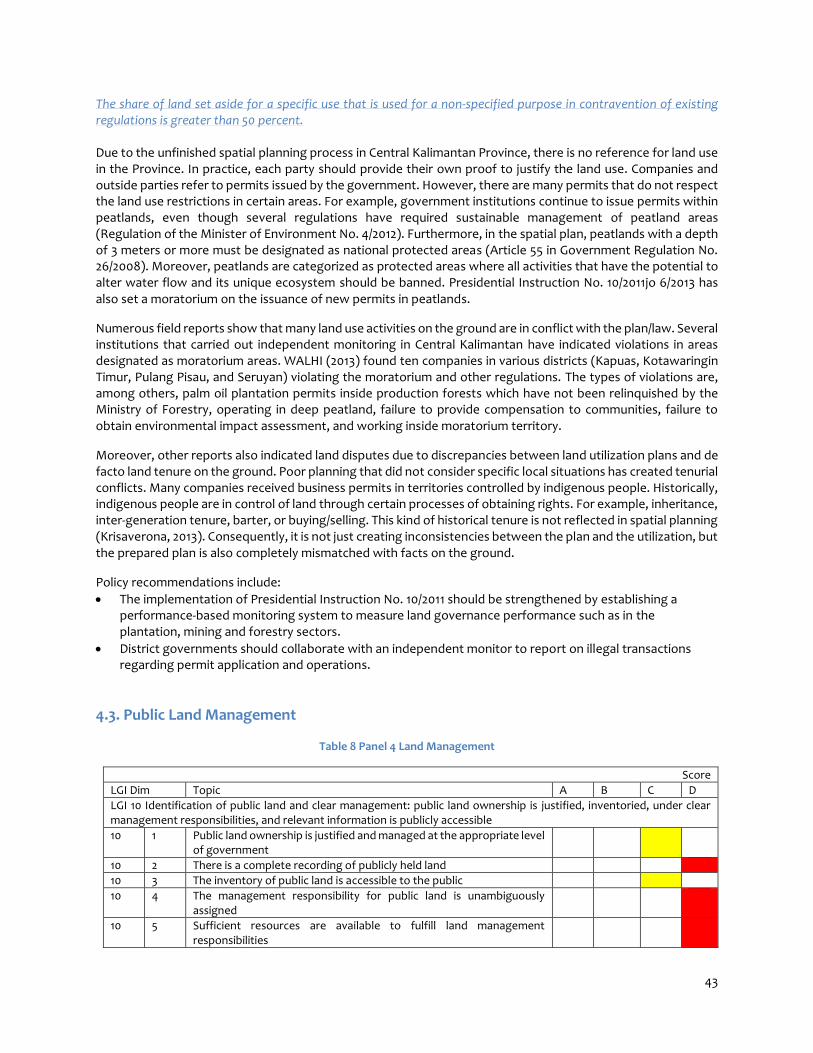
43
The share of land set aside for a specific use that is used for a non-specified purpose in contravention of existing regulations is greater than 50 percent. Due to the unfinished spatial planning process in Central Kalimantan Province, there is no reference for land use in the Province. In practice, each party should provide their own proof to justify the land use. Companies and outside parties refer to permits issued by the government. However, there are many permits that do not respect the land use restrictions in certain areas. For example, government institutions continue to issue permits within peatlands, even though several regulations have required sustainable management of peatland areas (Regulation of the Minister of Environment No. 4/2012). Furthermore, in the spatial plan, peatlands with a depth of 3 meters or more must be designated as national protected areas (Article 55 in Government Regulation No. 26/2008). Moreover, peatlands are categorized as protected areas where all activities that have the potential to alter water flow and its unique ecosystem should be banned. Presidential Instruction No. 10/2011jo 6/2013 has also set a moratorium on the issuance of new permits in peatlands.
Numerous field reports show that many land use activities on the ground are in conflict with the plan/law. Several institutions that carried out independent monitoring in Central Kalimantan have indicated violations in areas designated as moratorium areas. WALHI (2013) found ten companies in various districts (Kapuas, Kotawaringin Timur, Pulang Pisau, and Seruyan) violating the moratorium and other regulations. The types of violations are, among others, palm oil plantation permits inside production forests which have not been relinquished by the Ministry of Forestry, operating in deep peatland, failure to provide compensation to communities, failure to obtain environmental impact assessment, and working inside moratorium territory.
Moreover, other reports also indicated land disputes due to discrepancies between land utilization plans and de facto land tenure on the ground. Poor planning that did not consider specific local situations has created tenurial conflicts. Many companies received business permits in territories controlled by indigenous people. Historically, indigenous people are in control of land through certain processes of obtaining rights. For example, inheritance, inter-generation tenure, barter, or buying/selling. This kind of historical tenure is not reflected in spatial planning (Krisaverona, 2013). Consequently, it is not just creating inconsistencies between the plan and the utilization, but the prepared plan is also completely mismatched with facts on the ground.
Policy recommendations include:
The implementation of Presidential Instruction No. 10/2011 should be strengthened by establishing a performance-based monitoring system to measure land governance performance such as in the plantation, mining and forestry sectors.
District governments should collaborate with an independent monitor to report on illegal transactions regarding permit application and operations.
4.3. Public Land Management
Table 8 Panel 4 Land Management
Score
LGI Dim Topic A B C D
LGI 10 Identification of public land and clear management: public land ownership is justified, inventoried, under clear management responsibilities, and relevant information is publicly accessible
10 1 Public land ownership is justified and managed at the appropriate level of government
10 2 There is a complete recording of publicly held land
10 3 The inventory of public land is accessible to the public
10 4 The management responsibility for public land is unambiguously assigned
10 5 Sufficient resources are available to fulfill land management responsibilities

44
10 6 The key information on public land allocations to private interests is accessible to the public
LGI 11 Justification and time-efficiency of expropriation processes: the state expropriates land only for overall public interest and this is done efficiently
11 7 There is minimal transfer of expropriated land to private interests
11 8 Expropriated land is transferred to destined use in a timely manner
LGI 12 Transparency and fairness of expropriation procedures: expropriation procedures are clear and transparent and fair compensation is paid expeditiously
12 1 Compensation is paid for the expropriation of all rights regardless of the registration status
12 2 There is compensation for loss of rights due to land use changes
12 3 Expropriated owners are compensated promptly
12 4 There are independent and accessible avenues for appeal against expropriation
12 5 Timely decisions are made regarding complaints about expropriation
LGI 13 Transparent process and economic benefit: transfer of public land to private use follows a clear, transparent, and competitive process and payments are collected and audited
13 i Public land transactions are conducted in an open transparent manner No score is matched with the context
13 ii Payments for public leases are collected
13 iii Public land is leased and/or sold at market prices
13 iv The public captures benefits arising from changes in permitted land use
LGI 10. Identification of public land and clear management: public land ownership is justified, inventoried, under clear management responsibilities, and relevant information is publicly accessible. Public land ownership is justified in most cases by provision of public goods but responsibility is often at the wrong level of government The allocation and management of state lands in a province should be based on a provincial spatial plan. With the incomplete spatial planning process in Central Kalimantan, there are three legal implications: 1) district governments should follow the forest utilization procedure as outlined by The Ministry of Forestry; 2) The Ministry of Forestry is the institution mandated by law to manage and control state forests; 3) Ministerial Decree No. 529/2012 on forest classifications in Central Kalimantan is the legal basis used as the reference for spatial allocation, instead of the Provincial Regulation on the Provincial Spatial Plan of Central Kalimantan previously issued in 2003.
In practice, district governments have referred to the Provincial Spatial Plan when issuing licenses including in the areas that are classified as state forests by the Ministry of Forestry. Although district governments intend to implement the Forestry Ministerial Decree on forest classification, it will be challenging to revise the decisions that were made based on the previous Provincial Regulation. Many licenses have been affected, in some cases where they should immediately cease their operation, while in others they are required to fulfil additional requirements as outlined by the Decree. This situation will create many legal cases and will threaten economic growth due to the uncertainty it creates for investments in Central Kalimantan.
District governments find it more challenging to comply with the Ministerial Decree because the data related to forest classification from the Ministry of Forestry is very weak. During a change in government, a new district head often makes decisions that are contradict those of the previous administration. Thus, contradicting policies related to public land management occur not only between vertical agencies but are also embedded within the political system in the decentralized era.

45
Note: The panel members consisting of local government representatives scored B for this dimension during the panel meeting. However, since there was a bias in the assessment of this score by government representatives, the Expert Panel decided to give a score of C for this dimension based on the data and information gathered.
Policy recommendations include: Sectoral laws and regulations related to land use should be in line with spatial plans at the provincial and
district levels. The process of delineating forest boundaries should be accelerated including by carrying out the delineation
of indigenous people’s land claims. The oversight mechanism to monitor the use of forests should be strengthened and should include the Anti-
Corruption Commission, NGOs, and inspection agencies at the provincial level.
Public land is not clearly identified on the ground or on maps: there is no complete recording of publicly held land
Despite the uncertainties related to the spatial plans, most public lands have been identified on a map at least in Ministerial Decree No. 529/2012 and the Provincial Regulation on the Spatial Plan. The Ministry of Forestry and the Provincial Bappeda (Planning Agency) maintain a database of public land information. However, the classification and tenurial status of lands remains unclear.
Due to differing versions of land classification, at least 1.6 million hectares are currently in dispute in terms of their tenure and function between the provincial government and the Ministry of Forestry.28 In areas where land classification has been confirmed, several other issues are found, including: 1) overlapping permits with a total overlapping area between forestry, mining and plantation licenses of 382,573 ha29; 2) lack of clarity concerning the boundaries of forest areas, customary lands (indigenous forests), and free or non-free state lands (upon which civil rights are imposed by individuals, private or public corporations, and the government).
WWF and FFI reported that the total area of indigenous land claims is about 108,064 ha or 0.7 % of the area of Central Kalimantan,30 while AMAN reported that the total area of indigenous claims registered voluntarily by the BRWA so far is about 139,153.48 hectares. These claims have not been settled yet and are still contested with the state forest. The voluntary BRWA process is ongoing and the total area could increase, especially in relation to the implementation of the Constitutional Court decision No. 35/2012.
Besides the spatial plan, the management of public land has been detailed in Provincial Regulation No. 1/2011 on the Provincial Medium Term Development Plan of Central Kalimantan 2010-2015. The Plan, for instance, clearly mentions the intention to maintain forest areas as a part of the implementation of REDD+,31 while at the same time pursuing economic development through infrastructure development (railway network) and the plantation sector (i.e. palm oil).
Policy recommendations include: Provincial and national governments should revise forest classification based on ground checking of the
actual land use to re-identify the areas that are classified for protection and traditional use. The Provincial Government should have a one-stop land information authority that compiles
information from different land-based sectors. The authority can also serve as a designated body maintaining the land record information.
28The Central Kalimantan Roadmap to Low Deforestation Rural Development that Increases Production and Reduces Poverty, The Government of Central Kalimantan 29A joint report between the Sekala, the Provincial Government of Central Kalimantan and the REDD+ Task Force (2013) 30(REDD+ Task Force, Government of Kalimantan Tengah Province and Sekala, February 2013, Report No. 2) 31(Kalimantan Tengah as pilot project; refer also to Central Kalimantan Governor Regulation 36/2012 on Action Plan to Reduce Green House Gas Emission / Rencana Aksi Daerah Penurunan Emisi Gas Rumah Kaca (RAD-GRK))

46
All the information in the public land inventory is only available for a limited set of public property and there is little or no justification as to why records are not accessible
Different sectors that are involved in public land management have different perspectives about the public land inventory. First, public land inventory is defined as a spatial plan map, which by law should be published and made available to the public in conjunction with the Provincial Regulation on the Spatial Plan. Second, public land inventory may also be defined as the Master Book, which is managed by the Land Agency or Land Office to register taxpayers and land objects where the land and building tax is applied. The Master Book contains the names of right holders (tax subjects), land areas and the site plan. However, based on the experience of the Panel Members as revealed in the Panel Discussion held on 12 March 2014, the data recorded in the master book is incomplete, inaccurate and out of date. The Public cannot access the Master Book. In practice, the legal documents related to licenses issued for companies operating on public lands are scattered among different agencies and often cannot be accessed by public. A joint report between Sekala, the Provincial Government of Central Kalimantan and the REDD+ Task Force (2013, pg 5) mentions that:
“we need a special permit from government officials who hold the data or [we must] ask for the data from the company itself. [For] most concessions that need recommendations from the Governor for their licenses, a copy of the documents is available at the Provincial Secretariat in the economic and development division (Ekbang).”
Policy recommendations include: Comprehensive information related to public land should be collected and managed by the provincial and
district governments. Comprehensive data should be used for the spatial and development planning processes.
Public access to data should be guaranteed through a specific body or the role of Public Information Commission should be strengthened in order to simplify procedures for accessing information and validating the accuracy of data.
There is serious ambiguity in the assignment of management responsibilities over different types of public land with a major impact on the management of assets Different government agencies have their own mandates and responsibilities to manage public land. In state forests, the Forestry Law and Government Regulation No. 38/2007 stipulate that the national government, particularly the Ministry of Forestry, has the authority to manage state forests. However, following the Constitutional Court Decision No. 35/2012, customary lands within state forests should be excluded and they are to be managed under the authority of indigenous institutions, such as Damang and Mantir. The role of the Damang and the Mantir is authorized by Governor’s Regulation No. 13/2009 jo 4/2012. The regulation also stipulates the procedures to obtain a Statement Letter of Indigenous Land and Indigenous Rights on Land (Surat Keterangan Tanah Adat or SKTA). Based on this regulation, the management of indigenous lands should be excluded from state forests and be returned to respective indigenous communities. Outside state forests, the management of free and non-free state lands is under the authority of the National Land Agency (according to Government Regulation No. 10/2006). The authority to manage state lands (incl. permit allocation, procurement and monitoring of permits) is divided among different sectors including: plantation, mining, housing and public works. This fragmented approach often leads to conflicting tasks among agencies and eventually creates overlapping policies and regulations over the same area of public land. For example, the responsibility to manage peatlands is a somewhat competing arena that involves the forestry agency, land agency, plantation agency and environmental agency.

47
Policy recommendations include: The Provincial Government, the Ministry of Forestry, the Land Agency and indigenous institutions (the
Damang and the Mantir) should establish a joint cooperation to accelerate the process of delineating boundaries among contested claims.
A joint decision/decree should be established by the Ministry of Forestry, the National Land Agency and the Ministry of Internal Affairs to make sure concrete guidelines including steps and responsible institutions are outlined as a reference for provincial and district governments in managing state lands.
There are either significantly inadequate resources or marked inefficient organizational capacity leading to little or no management of public lands
In the forest sector, there is a generally accepted consensus that the budget and resources (including personnel resources) to manage Indonesia’s forests is limited. According to the Director General of Protection of Natural Conservation Forest of the Ministry of Forestry, the cost of conservation in 2012 was US$4 per hectare, which is the lowest in the world.32 Moreover, there are also limited resources for reviewing the applications of permits to utilize forests and for monitoring the compliance of companies with regulations. Therefore, it is challenging for the Ministry of Forestry to prevent forest encroachment. In Central Kalimantan, issues related to public land management, particularly in state forests, are mainly caused by the limited capacity of local officials. In the panel discussion that was held on 12 March 2014, a government officer from the Provincial Forestry Agency stated that the heads of local forestry agencies sometimes do not have a relevant background in forestry or in land-related issues. The selection of forestry agency heads is often based on the political preferences of district heads. Consequently, the heads of forestry agencies do not have the necessary capacity to perform their roles. In some cases, forestry agencies are only responsible for approving for political decisions made by district heads to issue licenses on state forests. Currently, there are many programs on REDD+ and climate change supported by donors and NGOs in Central Kalimantan. However, since there is no effective coordination among different initiatives, resources provided by NGOs and donors are not managed effectively to support the targets of forest and land agencies. Huge resources from donors have been spent to support hundred of meetings and few of them have directly improved policies and field work. Policy recommendations include: The government should issue a regulation to ensure that the selection process for forestry officials is based
on a merit system. If possible, an open selection process should be pursued when recruiting top positions in the bureaucracy.
Budget allocation should start with priority issues by considering the real needs of the province and districts. This is a strategy to avoid useless budget allocations and to use limited budget effectively.
32Darori Wonodipuro, Kontan, 17 January 2012

48
The key information for public land allocations (the locality and area of the land allocations, the parties involved and the financial terms of the allocation) is recorded or partially recorded but is not publicly accessible
The Ministry of Forestry manages information on public lands, particularly state forests. Public access to that information is regulated by Ministry of Forestry Decree No. P.7/Menhut-II/2011 on Public Information Service within the Ministry of Forestry. The regulation stipulates that the following information should be made available for public at all times: company names, types of permits, locations, and allowable annual cuts of timbers within concessions. The regulation also mentions that information about forest areas that are converted for mining and infrastructure should also be made available. However, important information that is required for monitoring remains confidential. For instance, the result of the audit by the Internal Monitoring Official (Aparatur Pengawas Internal) is considered confidential (Article 10). Information from the internal audit could provide information about violations of internal procedures and the necessary steps to prevent such violations. The information available in the forest classification map provided by the Forestry Agency is usually very general. There is information on land claims (or any proposals submitted). However, there is no integrated database that mantains key information about permits issued in productive forest lands. Also, there is no integrated database that stores all information about investment permits across sectors (mining, forestry, oil and gas exploration-exploitation or large scale plantations). Hence, when an applicant requests a parcel of land for a certain purpose, it is impossible to verify whether there are existing claims on the requested area. The same problem also occurs in non-state forests. The data on land allocations and land users are often managed separately by different government agencies. No integrated database is in place.
The Provincial Government has made some progress related to information management on permits granted on public lands. The public can access this information from the Central Kalimantan Province website (http://www.kalteng.go.id) or from the Ministry of Forestry. However, no information is available on the location of permits. Policy recommendations include: Key information on public land allocation should be disclosed to the public. The provincial and district governments should develop an inventory of information related to public lands.
Comprehensive data should be used as a basis for spatial and development planning. Public access to the data should be guaranteed through a specific body or the role of the Public Information
Commission should be strengthened in order to avoid complex procedures and in order to easily validate the reliability of data.

49
LGI 11. Justification and time-efficiency of expropriation processes: the state expropriates land only for overall public interest and this is done efficiently More than 50% of land expropriated in the past 3 years is used for private purposes. By law, an area within state forests can be relinquished for non-forest purposes (mining, plantation, or infrastructure). In 2011, the Governor of Central Kalimantan officially requested to change a total of 1,168,655 hectares of forest to non-forest.33 The main objective of the proposed changes is for private investments, particularly for private investors that have already begun their operations despite the incomplete provincial spatial planning process. A joint report between Sekala, the Provincial Government of Central Kalimantan and the REDD+ Task Force (2013) mentions that the total area licensed for all types of permits in Central Kalimantan is 12.1 million hectares or 78 percent of Central Kalimantan’s total land area. Up to 2013, 376 licenses have been issued for plantations, including: 92 Rights to Cultivate Land (HGU) with a total area of 610,421 ha or around 4 percent of the total land area of Central Kalimantan. Around 117 Plantation Business Licenses (IUP) have been issued with a total area of 1.4 million ha, while another 1.2 million ha have been issued for 111 Indicative Permits (Arahan Lokasi, AL) or Location Permits (Izin Lokasi, IL). The data collected by civil society groups also portrays a similar situation. Walhi Kalimantan Tengah (2013) shows that 87 percent of Central Kalimantan’s total area has been allocated for private investments. Policy recommendations include: The data regarding the transfers of rights over lands managed by the Land Agency must be compared with
detailed information on the granted IPPT/IMB in each district. An agency should be designated to manage integrated information on lands, including land cover, forests
and all types of natural resources. The role of the Public Information Commission should also be strengthened.
Between 30% and 50% of the land that has been expropriated in the past 3 years has been transferred to its destined use The expropriation of forest and/or lands on a large scale for personal interest is not in accordance with the function of forests in Central Kalimantan. This statement is supported by several reports, including Kemitraan (2011), Walhi Kalimantan Tengah (2013), and Karsa (2013). The ex-mega rice project area provides a good example. Initially, the status of the project area was production forest, and currently it is allocated for rehabilitation and reforestation purposes. The master plan for the development of this area is detailed in Forestry Ministerial Decree No. 55/2008 on the Master Plan of Rehabilitation and Conservation of the Peatland Development Area in Central Kalimantan (which is a derivative of Presidential Instruction No. 2/2007 on the Acceleration of Rehabilitation and Revitalization of the Peatland Development Area in Central Kalimantan). Currently, several activities can be found in the former ex-mega rice area, including 187 villages, 47 transmigration units, 23 plantation companies (where 12 obtained their permits from Kapuas District and 18 have obtained Plantation Business Permit/Ijin Usaha Perkebunan) and four mining companies that have obtained Mining Exploitation Permit/Ijin Kuasa Pertambangan (KP) from Kapuas District. Furthermore, the Land Agency has also issued 15,300 certificates for transmigration units in this area (Zakaria and Iswari, 2013). The Ministry of Forestry has reported that many companies are currently operating without proper licenses in Central Kalimantan. A report published by ICW, Kemitraan, and Kontak (2012) shows that around 282 plantations and 629 mining permits currently deviate from the normal procedure, involving a total area of seven million hectares. More than 100 companies are currently in the process of getting a permit, covering a total area of 2.7 million hectares. The incomplete spatial planning process has delayed the process for companies to obtain HGUs and has also led to difficulties in land expropriation. However, many companies have started their operations although they have not obtained the right to cultivate the lands.34
33(Decision of Forestry Minister RI (no. SK.292/Menhut-II/2011) 34Government of Central Kalimantan, 2013, The Central Kalimantan Roadmap to Low-Deforestation Rural Development that Increases Production and Reduces Poverty

50
The process of getting a proper licenses is time consuming. According to Sumardjono and Diantoro, the previous Ministry of Agriculture Decree No. 26/2007 on Plantation Licenses stated that the process should take a maximum of two years. In practice, however, companies might need to wait for up to 13 years due to several obstacles. One of the obstacles is the complicated license application procedure that involves administrative requirements at all government levels. The new Decree No. 98/2013 does not indicate any time frame limitation for issuing HGUs as this is under the authority of the National Land Agency. Policy recommendations include: The provincial spatial planning process should be completed immediately to provide a legal basis for land
expropriation and proper land use. An institutional strategy such as a joint collaboration among line agencies (forestry, land, mining, and
plantation) should be established to address the problem of misused land transfers. A law enforcement body, especially the Anti-Corruption Commission, should be involved in monitoring the
realization of expropriated land to prevent bribery, corruption and collusion
LGI 12. Transparency and fairness of expropriation procedures: expropriation procedures are clear and transparent and fair compensation is paid expeditiously
Compensation, in kind or in cash, is paid for some unregistered rights (such as possession, occupation etc.), however those with other unregistered rights (which may include grazing, access, gathering forest products etc.) are usually not paid By law, land compensation is perceived as different from land sale transactions, which are mainly for private uses. Land compensation is usually carried out to expropriate lands that will be used for the public interest by revoking rights on lands. In contrast, land procurement for private uses should be carried out directly by private actors through market transactions or other methods of rights transfer. Law No. 2/2012 and Government Regulation No. 71/2012 provide the legal basis for the implementation of land procurement for public interests. The regulations stipulate that land procurement is an activity of acquiring land by providing adequate and fair compensation to the entitled parties. The value of the land is decided by an appraisal determined by the Land Agency. The appraisal shall provide an estimation on the amount of compensation on land per parcel of land according to: 1) biophysical aspects of the land; 2) the space above it and underground; (3) buildings; (4) vegetation; (5) things related to land; and/or (6) other losses that can be appraised. Land procurement for public interest, by law, should be carried out voluntarily and should be based on the compensation principle (ganti untung). The compensation should be based on the recommendation of a committee established to determine the land value. In practice, compensation is provided to those who have land certificates. For those who do not have land certificates, compensation is perceived as a gift as there is no legal obligation. In the Panel Discussion held on 11 March 2014, an officer from the Land Agency mentioned:
“It is difficult to use a compensation scheme for lands without certificates since the basis for compensation is the rights listed in the BAL. The terminology that is commonly used for a case like this is “santunan” (gift). The amount is based on an agreement with the land holder.”
Several cases in Central Kalimantan showed that private investors (mostly oil palm companies) have provided low compensation to communities and a low value of land transactions. A case study carried out by Harvey (2013) reported a complaint to PT Agro Indomas (AI), which obtained a HGU in 1996 and 2000 (for the extended area), to cultivate for an oil palm plantation in Sembuluh, Lampasa, Tabiku and Bangkal of Seruyan District. The company was accused of taking over communities’ lands without any consent from the residents. As a response to the accusation, PT AI proposed to pay “compensation” in regard to the demands of the customary land

51
owners. In Tabiku and Bangkal, the company proposed to pay as much as US$0.00635 per square meter for fruits plantations and US$0.003 for light vegetations. PT AI argued that the company does not need to pay because it has been operating under proper permits. Until now, no agreement has been reached concerning the compensation, which has resulted in a persistent conflict (Harvey, 2013). Policy recommendations include: Compensation should be paid to land holders without certificates. Relevant agencies (forestry, land, mining,
and plantation) should agree on a policy to compensate the unregistered rights fairly. Customary rights should be formally recognized to provide a legal basis for fair compensation for any land
expropriation.
Where people lose rights as a result of land use change outside the expropriation process, compensation is not paid The Forestry Law has a specific provision on compensation for the loss of rights due to the designation of forest classification. This is stipulated in Article 67 particularly Section 3 and 4. However, in practice, no compensation will be provided for areas where customary claims are found. Based on the Forestry Law, classifying an area as a state forest limits the access of local people to the forest, including from extracting the timber unless a permit is obtained. With more than 60 percent of Central Kalimantan’s total land area classified as state forests, most local communities in Central Kalimantan are considered as living in state forests. Based on information from a government official in the Panel Discussion held on 17 March 2014, compensation cannot be done since so many villages are currently living in and around forest area. The government’s budget will not be sufficient to provide the compensation. Policy recommendations include: The national government, especially the Ministry of Forestry together with relevant government agencies,
should establish a compensation mechanism for those who are impacted by the designation of forest classification.
The indicators used to estimate the amount of compensation should not be determined entirely at the national level, but the local specific situation and non-monetary values of lands should also be considered.
35Based on USD exchange rate in 2000, 1 USD = IDR 8000

52
Less than 50% of expropriated land owners receive compensation within one year There is no definitive standard for the required time to pay compensation. For instance, the process of land acquisition for the development of the Mahir Mahar Inner Ring Road started in 2004. In 2013, not all indemnification has been paid. Some residents have already been resettled in another area (Antara, 2012). The process has been going on for 15 years and no agreement has been reached on the amount of payment. In some cases, not only the process is time consuming; the compensation that was provided for communities is also not in accordance with the value of land (measured by the sale price based on Tax Object Sale Value). In the forestry sector, a significant amount of land has been designated as state forests by the Ministry of Forestry since the 1980s. However, as was recognized by an officer from the Forestry Agency of Central Kalimantan in the Panel Discussion held on 17 March 2014, up to this point no land owner that has been affected was compensated. The mechanism for providing compensation is also not transparent. Forest communities have not been informed about the compensation that they are entitled to when their lands are affected by the designation of forest areas. The policy recommendation includes: Rights holders should be clearly informed about the mechanism to compensate their loss of rights. Avenues to lodge a complaint against expropriation exist but are somewhat independent and these may or may not be accessible to those affected The Land Procurement Law No. 2/2012 jo Government Regulation 71/2012 provides a legal basis for appeals against the land procurement process, especially regarding compensation. Land owners who have objections to the process or the amount of compensation offered may file complaints, question the decision and urge the applicant to seek other locations. Land owners may also bring the case to a state court to contest the decision or submit a civil claim to a general court.
In Central Kalimantan, Governor’s Decree No. 188.44/108/2012 regulates the settlement and the prevention of disputes over lands. The Governor’s Decree No. 188.44/57/ADHUM further stipulates the establishment of an institution to resolve land disputes. However, the institution does not have a legal mandate based on higher regulations, and is therefore considered to be an adhoc initiative. They are consequently not equipped with sufficient financial support and personnel to implement their roles effectively. The Panel Discussion held on 17 March 2014 highlighted the fact that only administrative courts can serve as independent institutions in dealing with appeals against the expropriation process. Other avenues cannot work effectively due to limited budget support and human resources. The only exception are local parliaments (DPRD) and the Dayak Peoples Councils (Dewan Adat Dayak), however, these institutions are often politicized so the process becomes more complicated. The policy recommendation includes: An independent body should be established supported either by government or self-financed to monitor
and resolve appeals against land expropriation. The body should be represented by stakeholders with a proportionate composition.
A first instance decision has been reached for between 50% and 80% of the complaints about expropriation lodged during the last 3 years

53
First courts at the district level set a Standard Operational Procedure (SOP) of a maximum of 6 months for handling legal cases. The same SOP is also applied to administrative courts. The Supreme Court evaluates the performance of lower courts annually based on the SOP. The promotion of personnel will be determined based on their performance. Most of the court cases can be resolved at the first court (Annual Report of High Court Central Kalimantan, 2011). However, as most of the cases are brought by parties to the higher court at the provincial level, the final decision of a case could take more than a year. Furthermore, there is no specific SOP to handle cases for complaints outside the court system, therefore, it is not possible to assess whether cases are handled in a timely manner. The Panel Discussion held on 17 March 2014 scored A for the performance of the court performance as most cases are solved within 6 months. However, when institutions outside the court system are also considered, the Panel decided to score B for this dimension. Policy recommendations include: An SOP for handling non-litigation complaint mechanisms should be developed together by non-litigation
initiators. A routine coordination mechanism between litigation and non-litigation mechnisms is required to handle
all complaints effectively. All the non-litigation complaint mechanisms should be integrated to avoid conflicting decisions.
Land Governance Indicator 13. Transparent process and economic benefit: transfer of public land to private use follows a clear, transparent, and competitive process and payments are collected and audited Public land transactions are conducted in an open transparent manner: no score can be assigned No score can be assigned to this Dimension since public auction or open tender processes for issuing licenses is not a common practice in Indonesia. This practice is not specific for the case of Central Kalimantan, but it is a general practice across Indonesia. The government has the authority to determine the utilization of forest resources. The Ministry of Forestry has the mandate to issue licenses according to the Forestry Law. The proponent can apply for permits based on procedures that have been stipulated by ministerial regulations. However, the process of issuing licenses is not transparent. A similar situation can also be observed in other sectors, including the issuance of permits for plantations. Although it is compulsory for permit holders to make public announcements on the licenses, in practice, companies do not seriously implement this requirement. The Panel Members reported that companies often make a public announcement in a very small box at a corner of media advertisement in local newspapers. People often cannot see such announcements and, most importantly, they do not reach those who are affected by the licenses. The process of allocation of forest permits through an open tender process was implemented in 2003. However, bidders were not selected based on their track records in forest management during the bidding process. As a result, any company that has carried out forest destruction can also participate in the tender as long as it can submit an adequate proposal (ICW and Greenomics, 2004). Government officers also have limited capacity to implement such a policy. Due to these major challenges, the Ministry of Forestry eventually considered the tender/auction regulation as an ineffective policy that was then terminated. Policy recommendations include:
A regulation for public auction or open tender process for land-based licenses should be established.
The capacity of government officers to carry out open tender/auction for licenses should be developed

54
Less than 50% of the total agreed payments are collected from private parties on the lease of public lands Indonesia’s regulations do not acknowledge the concept of land lease in forest areas. The Forestry Law stipulates that licenses can be granted to private companies to operate in state forests. The Basic Agrarian Law acknowledges rights on lands. The definition of lease of public lands can be associated with lands allocated for private investors for plantations and/or mining activities. Licenses can be granted to companies on public lands within or outside state forests. Companies should pay a certain amount of payment to obtain licenses on public land as stipulated by government regulations. For instance, companies should pay a certain amount in fees and levies to the government if timber is extracted during forest clearance for plantations. The company should also pay the land and building tax. It is almost certain that companies with proper permits to operate in public lands pay the land and building tax (PBB) and other types of payments according to licenses granted to them. However, in some cases, companies are operating without permits; therefore, no payment is made to the government. For instance, timber harvested during land clearing prior to operations (either for mining or plantations) that are not reported result in state losses. A study conducted by ICW (2011) shows that the Central Kalimantan Government lost around IDR 35.19 trillion due to illegal oil palm plantations covering as much as 1.1 million hectares between 2006 and 2009. ICW data has not included the environmental costs in this calculation (including losses that are caused by the impact of land clearance such as natural disasters including floods, landslides, and draughts). Diansyah and Faiz (2012) estimated the state losses based on the Ministry of Forestry’s 2011 data due to the release of forest areas in Central Kalimantan amounts to IDR 158 trillion. This amount is the largest portion compared to those of the other seven other provinces carrying out the relinquishment of forest areas. These losses were due to the utilization of forest areas by 268 plantation companies covering a total area of 3.70 million hectares and 598 mining companies operating in 3.4 million hectares (Diansyah and Faiz, 2012). Policy recommendations include: Tax monitoring should be strengthened through intensifying joint field visits of land/natural resources-
related agencies and the Revenue Agency to compare the actual operations with recorded data. Synchronized data should be regularly updated between the Provincial/District Land Agency and the
Revenue Agency.
4.4. Transfer of Large Tracts of Land to Private Investors
Table 9 Panel 5 Transfer of Large Tracts of Land to Private Investors
Score
LGI Dim LGAF INDICATORS AND DIMENSIONS A B C D
PANEL 5. TRANSFER OF LARGE TRACTS OF LAND TO PRIVATE INVESTORS
Land Governance Indicator 14. Private investment strategy
14 1 Policy and regulations are in place to unambiguously and publicly identify public/communal land that can be made available to investors, in agreement with legitimate land rights holders
14 2 A policy process is in place to identify and select economically, environmentally, and socially beneficial investments and implement these effectively
14 3 Public institutions involved in transfer of large tracts of land to private investors are clearly identified; without institutional and administrative overlap
14 4 Public institutions involved in transfer of large tracts of land to private investors share land information and effective inter-ministerial coordination mechanisms are in place to timely identify and solve competing land use assignment (incl. sub-soil)

55
14 5 Investors' compliance with business plans is regularly monitored and remedial action is taken if needed
14 6 Safeguards are established and applied to prevent that investments involving large tracts of land infringe on or extinguish existing legitimate tenure rights
14 7 Resettlement policy exists, but is only in part of the cases applied.
Land Governance Indicator 15 Policy implementation is effective consistent and transparent and involves local stakeholders
15 1 Sufficient information is required from investors for government to assess the cost-benefits of the proposed investments
15 2 A clearly identified process is in place for approval of investment plans and the time required is reasonable and adhered to
15 3 There are free, direct and transparent negotiations between right holders and investors; legitimate rights holders have always access to information
15 4 Contractual provisions are publicly available and include benefit sharing mechanisms with legitimate right holders
Land Governance Indicator 16 Contracts are made public, and agreements are monitored and enforced
16 1 Accurate information on spatial extent and duration of approved concessions is publicly available so as to minimize overlap and facilitate transfers
16 2 Compliance with safeguards is monitored and enforced effectively
16 3 Avenues exist for legitimate right holders to air complaints if investors do not meet contractual obligations and decisions are timely and fair
LGI 14. Private investment strategy A policy to identify land that can be made available to investors exists, based on ad hoc assessment of land potential and limited consultation with communities Central Kalimantan has a general policy to assess the feasibility of investments prior to granting a concession on state lands. This policy refers to Head of the National Land Agency Decision No. 2/2011 on Location Permits. However, the assessment depends only on desk research and very limited field verification. Communities are not often consulted properly about the investments. Firdaus et al. (2013) report an experience of a company that intended to open a plantation in Runtu village in 2005 and in Sungai Rangit Jaya village in 2004 in Kotawaringin Barat District. The project field operators and government officials at all levels reportedly never held any public meetings, information dissemination or public consultations, nor did they seek the community’s consent. It was also reported by community members that neither the company nor the government had provided them with information on, or consulted them about, the Environmental Impact Assessment (EIA/AMDAL) or High Conservation Value Assessment (HCVA) (Firdaus, et al, 2013: pg 58-59).
The Panel Discussion held on 17 March 2014 highlighted that local governments, particularly at the district level, do not have comprehensive information about available lands that have not been licensed out for large-scale investments. Permits are often allocated in areas where overlapping claims are found. The government then passes the responsibility on to the investors to negotiate with the existing claim holders. This is one of the major challenges for companies in getting proper permits. More than 100 companies are currently in the process of getting permits, covering a total area of 2.7 million hectares, although only 84 companies have already obtained the rights to cultivate the land (HGU) covering a 900,000-hectare area. Policy recommendations include: A comprehensive database of available lands for future investments should be developed, taking into
account the biophysical, social and environmental indicators. The database should also include information about large-scale investors and smallholders currently are operating in Central Kalimantan.

56
The quality of the Environmental Impact Assessment (EIA/AMDAL) process should be strengthened. If carried out properly, an EIA can inform decision makers as to whether an investment will have a negative social and environmental impact and how to mitigate the negative impacts if the investment is approved.
No policy process is in place to identify and select economically, environmentally, and socially beneficial investments and implement these effectively The Environmental Impact Assessment (EIA/AMDAL) is one of the main policies designed to prevent and manage environmental risks of investments. Law No. 32/2009 provides a legal basis for an EIA, which is further detailed by Government Regulation No. 27/2012 on Environmental License. Carrying out an EIA is an obligation for all types of activities that may potentially cause environmental damage. Ministry of Environment Regulation No. 5/2012 provides the list of activities that are obliged to carry out an EIA. The providing the results of the EIA is one of the requirements investors must follow to apply for the rights to cultivate the land (Hak Guna Usaha - HGU). Without an EIA, the HGU will not be issued. The Panel Discussion on 17 March 2014 revealed that licenses for large-scale investments were not granted based on a comprehensive analysis. The licenses are usually granted based on proposals submitted by investors. District, provincial and central governments are just passively waiting for prospective investors. The government usually does not pursue a competitive tender process prior to allocating a large-scale concession on state land. Hence, no competitive selection process takes place, particularly related to the environmental and social benefits of an investments. The monitoring of investments with potential negative environmental and social impacts remains inadequate. It is therefore not possible to assess the impacts of large-scale investments in Central Kalimantan. In the Panel Discussion, an official from the Plantation Agency revealed there is an on-going initiative to build an integrated monitoring system of plantation activities in Central Kalimantan. This system will allow the local government to monitor socio-economic and environmental impacts. The policy recommendation includes: Central Kalimantan Province should consider establishing an open tender system for better allocation of
state land for large-scale investors. This system can only be developed when the integrated database has been developed where available land for future investments is identified.
Institutions to make decisions are clearly identified but lack either capacity or incentives in ensuring socially beneficial outcomes, or their decisions are not always implemented. National and local regulations clearly stipulate the roles, responsibilities, and institutions that are involved in the transfer of rights over extensive land clusters. To operate on state lands, companies should obtain a significant numbers of permits from different government institutions. In the plantation sector, a company should obtain different permits from the local government (district head), the Ministry of Forestry (if the area was classified as state forest or has forest cover), and finally to the Land Agency for the HGU. Relevant regulations regarding institutional mandates are following:
Regulation of the Head of the National Land Agency No. 2/2011 on Location Permits. This regulation stipulates the role and responsibilities to relevant agencies for providing technical inputs to the head of district/municipality/governor before approving an application for a location permit;
Regulation of Ministry of Forestry No. P. 33/Menhut-II/2010 jo No. 44/Menhut-II/2011 on the Procedure for the Conversion of Convertible Production Forest. This regulation stipulates the roles and responsibilities of government agencies in the process of proposing forest conversion to non-forest area.

57
The coordination among institutions in the decision making process on the transfer of rights to large-scale investors is very weak. Data on land and forestry are not synchronized between related agencies. In the case of the application for forest conversions, Sumardjono and Diantoro (2013) found that there is no coordination between the Ministry of Forestry and the National Land Agency regarding the application of forest conversion to non-forest area. The Land Agency only receives a copy of an approval letter for conversion from the Ministry of Forestry in the HGU process. Agencies responsible for issuing permits prior to the HGU (including location permits, business permits, forest conversion permits) produce maps with conflicting boundaries. A license often cannot be issued due to conflicting maps. Furthermore, government officials dealing with the permit process at the district and provincial levels do not have sufficient capacity to assess the feasibility of an investment (neither skills nor funds). The policy recommendation includes: Better coordination between the Ministry of Forestry, the Land Agency, the Ministry of Agriculture and local
governments to simplify the licensing process. These agencies can determine jointly locations that can be allocated for large-scale investment and designate a single institution to represent different agencies in dealing with companies during the permitting process. This will significantly reduce transaction costs. An online and computerized licensing system can also improve coordination among different agencies in Central Kalimantan.
There is effective coordination to solve competing land use, although no policy is in place for effective inter-ministerial coordination to ensure that decisions on land use and land rights are well coordinated across sectors
Currently, there are available policies to allow for effective coordination between ministries to improve the decision making process on land use and large scale concessions. For example, a coordinating body for spatial planning at the District/City (BKPRK), Provincial (BKPRP), and Central (BKPRN) levels has been established. There are however challenges at the operational level. For example, the issue of the provincial spatial plan (RTRWP) in Central Kalimantan remains a lengthy debate between the Ministry of Forestry and the Provincial Government of Central Kalimantan.
There has also been a limited coordinated effort to define the total area needed for plantations, forestry and mining. For instance, the Ministry of Agriculture mentioned the target to develop 12.5 million hectares of oil palm plantations by 2019. In reality, there is no map available for future expansion of oil palm plantations. This will therefore require the Ministry of Forestry to release forest areas for plantations on an ad-hoc basis.
The policy recommendation includes:
Central Kalimantan Province needs to identify the total area required for large-scale investments and mae an agreement among different government institutions. Based on such an agreement, the government can develop a map and invite investors to submit their proposals for large-scale investments. The Government can then assess and select investors that will bring socio-economic benefits and also apply social and environmental safeguards in their operations
Monitoring is limited or only a portion of the results are accessible to the public The compliance of private companies with regulations is monitored periodically in some sectors. In the plantation sector, for instance, a plantation performance assessment (Penilaian Usaha Perkebunan – PUP) is carried out periodically to assess whether plantation companies have carried out their operations properly. Based on the result of this assessment, a company can then receive a certification issued for Indonesia Sustainable Palm Oil (ISPO). All oil palm plantation companies operating in Indonesia should obtain ISPO certification by 2014. In the forestry sector, the Ministry of Forestry has implemented a sustainable forest management certification scheme for commercial logging concessions and also for forest plantations. This is a compulsory certification for all forest concessions.

58
Of those 60 units, 22 have obtained certificates for sustainable production forest management (PHPL) and for the Timber Legality Verification System (SVLK). The online administration, verification and reporting system (SIPUHH online) will be effective very soon. This reporting system enables the provincial government to assess and evaluate the performance of concessions regularly. An assessment carried out earlier this year showed that twelve units are currently not active, since their annual plan (RKT) has not been approved by the Forestry Office and their production in previous years was below 50 percent of the target. On the basis of these findings, the Minister of Forestry gives concessionaires two months to develop an action plan to upgrade their performance. The Provincial Forestry Office monitors the implementation of the action plan for the non-active concessions. However, out of twelve non-active concessions, there are still five concessions that have not submitted action plans to the Provincial Forestry Office. The Provincial Forestry Office has given a warning letter that has to be responded to within a 1-month period. If there is no response, the second and the final warning letter will be issued. If the concession fails to respond the third and final warning letter, their concession will be terminated. Monitoring systems are therefore developed by each sector based on their mandates and responsibilities. For this reason, there is no integrated database of all companies operating in state lands and their performance. Monitoring is carried out as part of each agency’s mandate but the results are usually not published. The reasons are usually: (a) there is no information system that can be accessed easily by the public, and (b) the general public can only participate in monitoring specific cases, for example, criminal offences. Policy recommendations include: The Body for Spatial Planning at the provincial and district levels should have its mandate expanded to
include the monitoring of changes in the use and utilization of the area. There is a need to increase public awareness and participation in the monitoring of investments and to
facilitate public participation by providing widely-accessible information.
Safeguards (EIA, SIA, etc.) are partly in line with global best practice
Policies on safeguards are available, although they put more emphasis on environmental impacts than on social considerations. These policies are relatively in compliance with global standards. For example, the Environmental Impact Assessment (EIA/AMDAL) applies to all kinds of business activities that will have negative impacts on the environment. The Ministry of Forestry has also issued sustainability standards for the Timber Legality Verification System (SVLK) and the Sustainable Management of Production Forest (PHPL). For instance, one of the SVLK principles is to exclude the sacred areas of indigenous peoples from logging concessions, while for PHPL, a company should protect the areas with high biodiversity (high conservation value forests). Additionally, Minister of Agriculture Decree No. 19/Permentan/OT.140/3/2011 has issued some standards such as the Indonesia Sustainable Palm Oil (ISPO) standard for oil palm plantations. International instruments such as CITES and CBD have also been ratified, but they are only referred to as guidelines for national standards. At the provincial level, Provincial Regulation No. 5/2011 sets out some of social and environmental safeguard principles. The regulation requires plantation businesses to recognize and respect the land rights of Indigenous People (Section 11 subsection 2). As part of their environmental responsibility, recipients of plantation business licenses are required to identify and develop an inventory of flora and fauna located within the area being managed (Section 10, subsection 1). Despite being regulated by national laws and regulations, the recognition of indigenous peoples’ rights is often not clearly stipulated in sectoral regulations and policies. In practice, these standards are not monitored and implemented consistently. Some companies can obtain licenses without carrying out an Environmental Impact Assessment (EIA/AMDAL). The results of monitoring carried out by related agencies has never been disclosed to the public. Policy recommendations include:

59
Regulations on recognition of community/traditional rights and sectoral laws and regulations on forestry, plantation and mining should be integrated (or harmonized).
Public education with regard to the community's role in monitoring licensing performance should be carried out.
Resettlement policy exists, but is only in part of the cases applied. Resettlement policies in large-scale plantation or mining investments are not stipulated in Indonesia’s regulations. Law No. 2/2012 on the Acquisition of Land for Public Interest includes resettlement as a part of compensation (Article 36). However, this Law only categorize oil, gas and geothermal infrastructure as public interest development, and not plantation and mining activities. Resettlement is defined as a process of providing substitute land to the entitled party based on consensus in the land acquisition process. However, this provision has not been accompanied by the implementation guidelines of the resettlement process.
In the forestry sector, settlers within a concession should not be expelled; rather the areas occupied by communities should be enclaved. According to Ministry of Forestry Regulation No. P. 39/Menhut-II/2013, communities are later encouraged to partake in the business activities through some form of partnership with the company. There is no implementing policy put in place in Central Kalimantan to ensure the implementation of this regulation.
Policy recommendation includes:
The policy on fair resettlement (compensation) should be developed at the provincial and district levels, taking into account local policies and regulations
LGI 15 Policy implementation is effective, consistent, and transparent and involves local stakeholders Investors' business plans (application materials) require some evidence of technical viability, community consultation, and availability of resources but this is insufficient to effectively identify project risk ex ante In the forestry sector, investors are required to provide information related to the costs and benefits on their investments. For instance, to obtain a timber plantation license, an applicant should provide information regarding beneficiaries, costs, and potential benefits for beneficiaries, according to Ministry of Forestry Regulation No. P. 55/Menhut-II/2011. Investors’ business plans are also included in the investment application documents where prospective investors detail the technical and financial feasibility. However, this requirement is not complemented with information on investment risks and the results of community consultations. Consequently, investment costs can increase when investors have to deal with social conflicts due to the lack of participation of local communities in the proposed investment. In contrast to the forestry sector, investors in the plantation and mining sectors are not required to provide cost-benefit information of their investment plans. Investors are also not required to submit specific annual work plans related to their plantation and mining investment plans. The policy recommendation includes: As a part of administrative requirements for license applicant, the government can make it compulsory for
applicants to provide information on the cost-benefit analysis on various investments in the plantation, mining, and forestry sectors.
The review process for investment application related documents is not uniform and stable over time; in most cases, investors receive a response within 9 months of date submission.

60
In the forestry sector, guidelines on the licensing processes for investments, including required documents and the application process, have been developed. The main problem is the standard operating procedure related to the time required to process the licenses. Based on the Panel Discussion, a company may take up to 9 months to receive a response to a proposal that has been submitted. The process of screening documents for obtaining an IUPHHK should only take around three months. However, a license can only be issued approximately seven months after the completion of an environmental impact assessment and the mapping of concession areas. In the plantation sector, Provincial Regulation No. 5/2011 has stipulated the necessary steps to review an investment plan and the time required for obtaining approval. For example, the authorities issuing the licenses must provide a response whether an application is approved of rejected in: (1) twelve (12) working days for the Cultivation Registration Certificate (STD-B) and Plantation Registration Certificate (STD-P) from the acceptance of the application; (2) twenty four (24) working days for the Plantation Business License (IUP), Cultivation Plantation Business
License (IUP-B) and Management Plantation Business License (IUP-P) from the acceptance of the application;
(3) six (6) working days for the Plantation Crops Change Registration Certificate (STD-PJTP) and Plantation Crops Processing Business Development Registration Certificate (STD-PUPHP) from the acceptance of the application;
(4) twelve (12) working days for the Plantation Crops Change License (IPJTP) and the Plantation Business Development for Processing License (IPUPP) from the acceptance of the license. For mining, Local Regulation No. 15/2012 has provided the process for granting approval and the time required for obtaining approval for mining licenses and post-mining reclamation. Policy recommendation includes: Monitor the performance of institutions responsible for issuing licenses to accelerate investments. Limited negotiations between rights holders and investors; legitimate rights holders do not have always access to information In the plantation sector, Provincial Regulation No. 5/2011 clearly mentions that plantation businesses are required to consult indigenous people regarding the communal lands for plantation development and obtain their consents prior to the start of their businesses (Section 11, Subsection 4). However, the regulations do not stipulate that the negotiation process should be carried out freely, transparently and in an informed manner.
In practice, plantation companies often start their operations based on the licenses issued by district heads without undergoing a negotiation process with rights holders in a transparent, free and well-informed manner. For example, Firdaus et al. (2013) report that both oil palm companies and the government have never informed or consulted the community of rights holders about the environmental impact assessment (EIA/AMDAL) and the assessment for high conservation value areas. In the forestry sector, an officer from the Provincial Forestry Agency mentioned in the Panel Discussion held on 17 March 2014 that a company is not required to carry out public consultations with communities surrounding the proposed investment area until the administrative requirements are completed.
Policy recommendations include: There is a need for regulations that can increase the participation of the community of land 'owners' in the
large-scale land-based investment process
The document on licensing plans should require the document on the results of negotiation with the community. The document of negotiation with community should be takenprior to licensing review conducted by the government
The majority of contractual arrangements do not include information on benefit sharing.
61
In the plantation sector, Agriculture Minister’s Regulation No. 98/Permentan/OT.140/9/2013 stipulates that governors or bupati/mayors should make announcements about proposals for plantation development to the surrounding communities. Moreover, oil palm companies are required to build partnerships with local communities, which are detailed in written agreements, less than 3 (three) years after licenses are granted. Plantation companies that have obtained a Plantation Business License (IUP) or Cultivation Plantation Business License (IUP-B) are also required to build plantations for local communities that cover at least twenty percent of the total plantation area. However, contracts regarding these partnerships are not always open to the public. The profit sharing mechanism in the partnership schemes varies depending on negotiations between companies and communities. In the forestry sector, lands owned by local communities are excluded from a company’s concession and can be institutionalized in the form of community-based forestry. In other sectors, no specific regulation exists relating to the participation of communities as the right holders. Policy recommendations include: The Government of Central Kalimantan should open information on large-scale investment to the public.
This will allow for greater participation of communities to monitor the investments. Public awareness should be increased to ensure participation of local communities in the monitoring of the
performance of investments. The results of public participation should be made publicly available to show the public that their feedback is seriously considered.
LGI 16 Contracts are made public, and agreements are monitored and enforced Spatial information and temporal information is available to relevant government institutions but not accessible on a routine basis by private parties According to the Public Disclosure Law, all public bodies are required to provide, deliver and/or publish public information under its authority. Each ministry should translate these principles into legislation within the scope of their respective authorities. In the plantation sector, the Ministry of Agriculture regulates that governors/bupatis/mayors should provide information related to the permit process to encourage public participation. The Minister of Agriculture’s Regulation No. 98/Permentan/OT.140/9/2013 stipulates five important stages where information should be disseminated to the public to allow for public participation in the permit process. In the mining sector, Provincial Regulation No. 15/2012 stipulates that the Governor is obliged to announce plans for mining operations in the Mining Permit Region (WIUP), the Exploration Mining Permit (IUP) and the Production Operation openly to the public. However, there are no specific provisions governing the time required to obtain public inputs and how to take them into consideration when issuing licenses. In the forestry sector, each application for a specific permit is open to the public for input for a certain period. The process of licensing takes into considerations public input. Due to the incomplete spatial planning process, it is difficult for relevant officials to provide accurate information on large-scale business proposals. The overlapping licenses between forestry, mining and plantation activities in Central Kalimantan indicate the failure to deliver public information related to permits in the province. It is crucial to develop an integrated database of the existing large-scale investments and to release information to the public to ensure public participation. Policy recommendations include: It is imperative to ensure the implementation of the regulations on public participation. The public should
be made aware of the regulations.

62
To ensure public participation for future investments, it is imperative to develop a robust database of the existing large-scale concessions in Central Kalimantan. This will inform the public and government officials and enable them to conduct necessary assessments of proposals for large-scale investments.
There is little third-party monitoring of investors' compliance with safeguards and mechanisms to quickly and effectively ensure adherence are difficult to access for affected communities In practice, the monitoring of safeguards in large investments is not sufficient. Many violations of regulations have occurred and caused conflict, environmental degradation and income losses for the state. For instance, UNDP’s 2012 Participatory Governance Assessment in ten provinces, including Central Kalimantan, reports the limitation of government agencies in handling conflicts, the administration of community rights, as well as law enforcement and the prosecution of forest-related crimes. In terms of law enforcement, communities living in and surrounding forest areas have not been involved. Moreover, judges with appropriate training and qualifications to handle forestry and environmental crimes are absence in areas where these cases are occurring (UNDP Indonesia, 2013: pg 109). Besides communities and judges, government agencies should also have inspectors responsible for monitoring the implementation of safeguards. However, the Panel Members confimed that inspectors are mostly appointed by their own institutions, therefore, they are not independent in performing their tasks.
In the plantation sector, regulations at the national and provincial (Central Kalimantan) levels have provided numerous opportunities to monitor the implementation of safeguards and to design measures to enforce safeguards. For example, Provincial Regulation No. 5/2011 states that the government should issue a warning for plantation businesses that do not develop a partnership with the community. The permits can be revoked in the case of failure to build the partnership. A similar requirement is also found in the mining sector. In the event of violations of the laws and regulations, the governor may revoke the mining permit. Policy recommendations include: 1. In line with the Minister of Home Affairs’ Regulation No. 67/2012, there should be a special government
unit at the provincial level to monitor the implementation of safeguards. 2. The capacity of inspectors (auditors) that are embedded with licensing agencies to monitor safeguards
should be increased. 3. Draft Government Regulation on Strategic Environmental Assessment should be implemented in
accordance with Law No. 32/2009. There is little third-party monitoring of investors' compliance with contractual provisions and mechanisms to quickly and effectively reach arbitration are difficult to access for affected communities but work for investors Legally, rights holders can file complaints if investors do not fulfil their obligations. In the forestry sector, the Basic Forestry Law has a specific provision on public complaints. In the plantation sector, Governor Decree No. 188.44/108/2012 established a team for handling conflicts. The team has started compiling data on land conflicts. Around 278 cases have been identified as of December 2012. Most of the cases are associated with plantation licenses, while the remaining 6 cases related to mining and other cases.
The National Land Agency is responsible for assessing and handling land disputes and conflicts. The Land Agency recorded that land disputes and conflicts handled by the Land Provincial Office at the provincial level in 2010-2012 were around 132 cases. At the district level, around 352 cases were recorded. During the same period, several other agencies were also dealing with land disputes and conflicts, such as the plantation, forestry and other agencies (handling as many as 37 cases), the parliament (1 case) and other law enforcement agencies (8 cases). In the mining sector, the local government has the authority to resolve conflicts at the community level, however, there is no concrete regulation regarding how the mining related conflict should be handled. Generally, the conflict handling mechanism has not effectively considered the time required to resolve conflicts. There has been no procedure developed to ensure the team functions effectively and efficiently.

63
Policy recommendations include: A monitoring system should be established, preferably by an independent party, to monitor the contracts
between license holders and the government. A system should be developed to allow the public to file their complaints regarding the performance of
investors that do not comply with the obligations stipulated in agreed contracts.
4.5. Public Provision of Land Information: Registry and Cadastre
Table 10 Panel 6 Public Provision of Land Information: Registry and Cadastre
Score
LGI Dim LGAF INDICATORS AND DIMENSIONS A B C D
PANEL 6. PUBLIC PROVISION OF LAND INFORMATIN: REGISTRY AND CADASTRE
Land Governance Indicator 17.Mechanisms for recognition of rights
17 1 There is an efficient and transparent process to formalize possession that is in line with local practice and understanding)
17 2 Non-documentary evidence is effectively used to help establish rights
17 3 Long-term unchallenged possession is formally recognized
17 4 First-time registration on demand includes proper safeguards and access is not restricted by high formal fees
17 5 First-time registration does not entail significant informal fees
Land Governance Indicator 18. Completeness of the land registry
18 1 The cost of registering a property transfer is low
18 2 The mapping or charting of registry records is complete
18 3 Economically relevant private encumbrances are recorded
18 4 Socially and economically relevant public restrictions or charges are recorded
18 5 There is a timely response to requests for accesssing registry records
18 6 The registry is searchable
18 7 Records in the registry are easily accessed
Land Governance Indicator 19. Reliability: registry information is updated and sufficient to make meaningful inferences on ownership
19 1 Information regarding land rights maintained in different registries is routinely synchronized so as to reduce transaction cost for users and ensure integrity of information
19 2 Registry/cadastre information is up-to-date
Land Governance Indicator 20 Cost-effectiveness and sustainability: land administration services are provided in a cost-effective manner
20 1 The registry is financially sustainable through fee collection Cannot be rated since there is no regulation and practice related to this dimension
20 2 Investment is sufficient cope with demand and provide high quality services
Land governance indicator 21 Fees are determined transparently to cover the cost of service provision
21 1 The schedule of fees is publicly accessible
21 2 Informal payments are discouraged
21 3 Service standards are published and monitored

64
LGI 17. Mechanisms for recognition of rights
The process for the formal recognition of land ownership is not clear and is not implemented effectively, consistently or transparently The process of formalizing land ownership can often be considered inefficient, inconsistent and non-transparent. Overlapping claims create confusion and conflicts. One of the requirements to obtain a land certificate from the National Land Agency at the district level is an SKT (Land Statement Letter). An alternative to an SKT is a Letter of Land Ownership (Surat Pernyataan Pemilikan Tanah or SPT) from the administrative village head (lurah or kepala desa). The subdistrict head (camat) should further approve the SKT or SPT. The granting of the SKT/SPT is recorded manually in the book of records. For example, an interview carried out by the Panel Expert with an administrative village head in Palangka Raya revealed that many books of records are currently missing, making it challenging to verify whether an SKT/SPT had previously been issued on a piece of land. No clear process has been established related to the issuance of the SKTA. This issue is complicated as there is no clear boundary of customary (adat) territory (kadamangan), which in practice is overlaps with other government administration areas (kelurahan or kecamatan). The Land Agency, however, only accepts SKTAs with the signatures of village administrative heads. Otherwise, an SKT/SPT will be required to accompany an SKTA. At the same time, customary lands cannot be certified within state forests as the Constitutional Court Decision No. 35/PUU-X/2012 has not yet been applied. There is no coordination between kadamangan and government administrations that work on land registration (kelurahan, kecamatan and the Land Agency). The process relies heavily on the testimonies of neighbouring land owners and other witnesses. Moreover, the eligibility criteria, the maximum land size, the minimum number of years of occupation and the standard fee for customary land registrations are unclear. Furthermore, SKTA misuse/abuse has also been reported (e.g. high fees applied to process SKTAs, SKTAs issued to non-members of indigenous communities, and SKTAs that serve to open access to sell customary land to a third party). Policy recommendations include: Public should be provided with sufficient information on the process and the cost to ensure efficiency and
transparency. A comprehensive database on lands should be improved (e.g. computerized, updated and synchronized
database as well as building links to the BPN database). A system to monitor the application progress should be developed. District governments should support the development of clear demarcation of customary areas over
which Damang can issue SKTAs should be developed Damang and Mantir should coordination with BPN to produce an efficient process of adat land
administration and registration Databases of land records data should be synchronized among offices working on land administration and
registration (BPN, kelurahan and kecamatan). Land agency should have safeguard policies on the implementation of formal recognition policies to
protect the system to avoid misuse/abuse
Non-documentary forms of evidence are used to obtain recognition of a claim to property along with other documents (e.g. tax receipts or informal purchase notes) when other forms of evidence are not available. They have less strength than the provided documents
For the first time registration, land owners who do not have written proof can use non-documentary forms of evidence as stipulated by Government Regulation No. 24/1997. Non-documentary evidence can be in the form of testimonies of neighbours and other proof to show that the land has been occupied for more than 20 years including physical constructions (permanent/non-permanent buildings, canals, bridges), planted vegetation, and

65
other evidence. With non-documentary evidence, one can obtain an SKT or SPT from the village head. The SKT/SPT is then used to obtain a land title in the form of a land ownership certificate (Sertifikat Hak Milik). In terms of customary rights, the regulations do not recognize a claim that uses traditional boundaries unless it is shown in a map. To obtain an SKTA, there is no minimum period for the length of land occupation required. Regardless of ethnic background, a person (Dayak or non-Dayak) who purchases customary land can obtain a an SKTA by showing proof of the transaction and the with testimonies from neighboring land owners and other witnesses. According to a Damang’s book of records, on a number of occasions SKTAs were issued to non-Dayak individuals, even though they were clearly non-indigenous peoples. The land recording system, which includes both registry and cadastre, is still carried out manually and with no cross checking with the village/administrative village/district and BPN database.
Policy recommendations include: Testimonies and non-documentary forms of evidence should be verified since cases of fraud have been
reported The eligibility and the minimum period of occupation of a person or a group on customary land should be
clarified to ensure that the aim of the Governor’s Regulation to protect customary land and communities is accomplished.
Legislation exists to formally recognize long-term, unchallenged possession but due to the way this legislation is implemented, formal recognition is granted to very few or no applicants for recognition on either public or private land
The national regulations stipulate that long-term possessions can be recognized formally, by issuance of certificates. Nevertheless, in two Panel Discussions carried out on 12 and 13 of March, three of the Panel Members expressed that a certificate does not necessarily guarantee the security of rights. In Palangka Raya, land conflicts occurred because different claims were found for the same land. Sometimes, an SKT/SPT is considered stronger than a certificate because the Land Agency narrowly focuses on the submitted documents of the applicants and pays less attention on verifying historical claims on the land. As elaborated previously in Panel 1, some of the SKT/SPT holders found that their lands were certified under another name. Similar court cases were also documented in the Supreme Court for Civil Court Decision of Pangkalan Bun No. 63/Pdt.G/2011/PN.P.BUN and in the Administrative Court Decision of Palangka Raya No. :10/G/2008/PTUN.PLK. Both cases have revealed the failure of the Land Agency to capture the complexity of claims on the ground as the basis to issue certificates. As a result, some administrative courts revoke the land certificates, while the government has been forced to pay fines for the claimant’s losses by civil courts. Another experience of the Panel Members shows that there are groups in Palangka Raya taking advantages of the idle lands. The groups identify the lands and, when no daily activity is found, they apply for a certificate. The process usually involves bribery.
Without a good database on land inventories and owners, it is difficult to justify a claim based only on long-term occupation. This situation was highlighted again in both of the aforementioned Panel Discussions. To formalize a claim, an applicant should go to the District Land Office, which is costly since people live in isolated areas. PRONA (Proyek Operasi Nasional Agraria), a free program to register and certify land, sometimes cannot be accessed by people in remote areas. The Discussions also revealed that land brokers often have direct access to information from the Land Office regarding a land certification program. Policy recommendations include: The Land Agency should improve the registry and cadastre system and data base maintenance. The Land Agency should allow for testimonies and non-documentary forms of evidence to be verified
since there have been cases of fraud reported.

66
On-demand registration includes proper safeguards to prevent abuse and costs do not exceed 2% of the property value. The incomplete spatial planning process has resulted in the suspension of the land certification process between 2009 and 2010. The Land Agency resumed providing its service on land certification in October 2010 for certain areas where no disagreement on land classifications between the Ministry of Forestry and the Provincial Government was found. Government Regulation No. 13/2010 has clearly stipulated the land registration fee amounts. The first time registration fee is around 2 percent of the land value. There is no regulation on the fee to process an SKTs/SPTs at the village level. Governor’s Regulation No. 13/2009 jo No. 4/2012 also did not mention a standard fee to obtain an SKTA. However, the primary issue related to registration fees lies with the informal fees. Many people are reluctant to seek a certificate, as they will be required to pay taxes. Additionally, there is no specific regulation to prevent fraud in term of the process and cost. Policy recommendations include: 1. The spatial planning process in Central Kalimantan should be expedited 2. The information regarding formal fees should be widely disseminated to the public (not only in the land
office). 3. Safeguards to prevent fraud regarding informal fees should be established. There are informal fees that need to be paid to effect first registration and the level of informal fees is significantly higher than the formal fees Informal fees are often much higher than the formal registration fee. Informal fee amounts vary from hundreds of thousands of Rupiah to millions of Rupiah. Government Regulation No. 13/2010 stipulates that the applicant’s costs of transportation, accommodation and meals for the cadastre team from the Land Agency should be paid by the users. Yet, there is no standard for these costs. This situation creates high informal fees. For instance, PRONA was initiated by the central government to provide a service for low income families. However, an interview with a family in Palangka Raya by the Panel Expert shows that a family was asked to provide around US$250 when applying for the program at the village administration level. Poor families often cannot afford the fee; therefore, they do not attempt to participate in the program. The Panel Discussion held on 13 March 2014 revealed that most of the land certificates are owned by rich people and those who are assisted with aid money, as well as in areas where investments will be carried out such as plantation investments and mining. Normal fees to obtain an SKT/SPT range from Rp. 250,000 (US$25) to Rp. 500,000 (US$50), although higher fees (>Rp. 1,500,000 or US$150) are often reported. Moreover, fees to obtain an SKTA ranges from Rp. 1,000,000 (US$100) to Rp. 1,300,000 (US$130). Policy recommendations include: The standard fees should be established and informed to customers A system should be built to monitor the progress of first time registrations/applications and other land
services in the BPN offices, preferably an online system. Safeguards should be put in place to prevent land registry officials at BPN, village/administrative village
and kadamangan offices from abusing their power (rent-seeking behavior) LGI 18. Completeness of the land registry The cost for registering a property transfer is equal to or greater than 5% of the property value

67
Government Regulation No. 13/2010 stipulates that the cost of transferring a property is 1 percent of the value of the land. However, the cost will increase significantly when the value of the land liable for taxation is more than the non-taxable value (a maximum value of Rp. 60,000,000). This is because the income tax (PPh) and BPHTB (Acquisition Levy Of Land And Building Rights) should be paid before the application for certificate transfer can be processed. The amount of taxes and fees are 9.5 percent of the total land value minus the non-taxable value. A reduced fee is applicable for the transfer of rights by inheritance from a parent to a child and bequest. In addition to the formal fees, applicants must often pay informal fees. The amounts vary depending on the area and whether notary services are used. These informal fees often add extra costs to the land rights transfer. The policy recommendation includes: A subsidy should be provided to citizens from low-income backgrounds to register a property transfer. Less than 50% of records for privately held land registered in the registry are readily identifiable in maps in the registry or cadaster The National Land Agency (BPN) initiated a computerised land registry and cadastre system and database management system in 1997. The system allows for easy maintenance and increases the accuracy of information. In 2007, the office of the Land Agency in Palangka Raya Municipality established a computerized cadaster system. Since then, land registration data can be accessed digitally. The Land Agency claimed that land certificates issued before 2007 are updated regularly especially when there is a land transaction that requires certificate transfers or land re-surveys. The system is linked to the provincial spatial data that is maintained by the Planning Agency (BAPPEDA). In practice, the public cannot access the registry records. As clarified in the Panel Discussion held on 13 March 2014, the Land Agency’s data sometimes conflict with the real situation on the ground. SKT/SPT data at the village and district levels are registered and stored manually, although a few villages developed a computerized SKT/SPT database early last year. Most of the maps produced as a requirement of the SKT issuance were not recorded/archived properly. Many SKT/SPT register/record books are also missing in a number of villages, which makes it impossible to accurately check the status of a piece of land using the manual registry system. Policy recommendations include: Province/district spatial data related to land registration should be accessible for the public. Province/district Information Commission should cooperatee with the Planning Agency that holds the
regional spatial data. The registry system and database management system should be improved from a manual to a
computerized system. Relevant private encumbrances are recorded but this is not done in a consistent and reliable manner The Basic Agrarian Law and Law No. 4/1996 define the types of encumbrances on land titles. The process for registering encumbrances is described in a number of regulations. To register an encumbrance, first a land-titling official must grant the encumbrance, which is then included in a written deed. This can then be registered at the District Land Office. Despite the importance of registering and recording private encumbrances on land records in the Land Offices, in practice, it cannot be easily carried out. The Panel Discussion held on 13 March 2014 pointed out that an encumbrance is a private transaction that is not directly linked to the land registry system in the Land Office. Therefore, it is difficult for the Land Office to update the status of land including encumbrances. The Land Agency in Palangka Raya indicated that there were an increasing number of encumbrance right registrations after 2011. This may be because of the lifting of the moratorium on land registrations (2007-2010) and high economic development in urban areas (more people are borrowing money from commercial banks for

68
their businesses). The record is especially lacking on the status of land certificates used as a collateral in informal money borrowing. Policy recommendation 1. Socialization on the importance of recording private encumbrances. 2. Online computerized system will allow easy recording and checking by interested parties. Socially and economically relevant public restrictions or charges are not recorded There is no record of public restrictions or charges in the Land Offices. The Planning Agency keeps information on social and environmental public restrictions. For example, a public (rights holder) objection against land acquisition for an infrastructure development project is recorded by the Planning Agency. The objective of the record is to ensure the case will be incorporated as a consideration for the next planning process. However, the incomplete provincial spatial planning process has created uncertainty regarding the status of land. Furthermore, the social and economical restrictions on land recorded by the Planning Agency are only available for court cases. Policy recommendations include: The Land Agency should improve its system and land database by including data on public restrictions and
changes to land in the Land Office or in other offices working with land administration. Public announcements related to the restrictions and possible future changes of the ownership status of
land should be disseminated in the media The process of finalizing the provincial spatial plan in Central Kalimantan should be expedited It is not unusual that an extract or copy of a record cannot be produced in response to a request as the original record cannot be located According to the Regulation of the Head of the National Land Agency No. 1/2010, public access to a certain kind of registry record is prohibited. In an interview with an official of the Public Information Commission in Palangka Raya, the Panel Expert was informed that the Public Information Commission was prohibited to access information from the Provincial Land Agency when it was trying to resolve a land information case. This is in violation of Law No. 14/2008 that stipulates that the commission is assigned to handle a public case related to the right to information. In the panel discussion on 13 March, panel members expressed that, based on personal experience, the Land Agency appears to be faster in responding to requests from landowners. Landowners can check the information in land offices and obtain a copy or extract of a land document (in the form of a Land Registration Letter) within one working day. This is in accordance to the standard operating procedure (SOP) of the National Land Agency stipulated in the Regulation of the Head of the National Land Agency No. 1/2010. However, the Land Agency is reluctant to provide information related to disputed areas, even if the information is requested directly by the landowner. For customary lands, there is no specific SOP regarding the timeframe to process an SKT/SKTA. The information management of SKT/SKTA has not been computerized, so the process for finding information is time consuming. Applicants are sometimes asked to search for relevant documents manually on the shelf by themselves. The policy recommendation is: Regular monitoring (or auditing) should be carried out to make sure the time to access a record is in
accordance with the standard operating procedure. The records in the registry can only be searched by parcel

69
In Palangka Raya, the Land Office has established a computerized system to store land records. The system allows the office to search land records by rights holder names and by land parcel. However, in the remaining 13 districts, no computerized system is available. The information on SKTs and SKTAs at the village and district levels is managed manually. This system only allows for searching information based on names, registration numbers and date. There is no copy of the SKT or its map in the archive. Based on the information from the Land Agency officer in Palangka Raya, only recent land data (later than 2000) can be accessed. The Land Agency only has limited financial resources and written documents to trace the land records before 2000. Note for the score: the situation in each of land offices varies therefore they will have different scores. The land registry could be searched using either name or land parcel. It is very rare to find both in land offices. Thus, the Panel Discussion held on 13 March 2014 decided to score a B and C for this Dimension. Policy recommendations include: The land information system should be improved from a manual to a computerized system at the village and
kedamangan levels. The local capacity should be strengthened to support the digitalization of SKT/SKTA. Copies or extracts of documents recording rights in property can only be obtained by intermediaries and those who can demonstrate an interest in the property upon payment of the necessary formal fee, if any Land owners, or public notaries on behalf of land owners, can request for copies of their certificates in land agency offices. Land agency offices will attend to the request by checking the document and issuing an SKPT (Surat Keterangan Pendaftaran Tanah or Land Registry Record). According to Government Regulation No. 13/2010, a formal fee of Rp. 50.000 will be applied. However, the public cannot access information that is classified as confidential. Regulation of the Head of the National Land Agency No. 6/2013 on Public Information Service within the National Land Agency lists information that is not available to the public. The restriction on accessing public information is meant to prevent land speculators from taking advantage of and manipulating the information. Information that cannot be released to the public may be provided to government institutions if necessary when the information is required by those institutions to provide public services. The request of information from government institutions will, however, be assesses on a case-by-case basis. The Provincial Plantation Agency in Central Kalimantan has made some progress in providing information to public. As revealed in the Panel Discussion held 13 March 2014, information related to HGU can be accessed easily within two days from the Plantation Office without charge. However, copies or extracts of documents at the district and village levels are difficult to obtain since the information system is still managed manually and many register books are missing. Most of the District Land Agency Offices in Central Kalimantan cannot provide registry record easily. Policy recommendations include: Interested parties with good and credible intentions should be able to access land records. The land information system should be improved from a manual to a computerized system at the village and
kedamangan levels. The local capacity should be strengthened to support the digitalization of SKT/SKTA.
LGI 19. Reliability: registry information is updated and sufficient to make meaningful inferences on ownership Few or none of the relevant links exist There is no integrated information system that allows for synchronization of land information from Mantir, Damang, village heads, subdistricts and Land Agencies. Currently, the Land Agency at the district level and the

70
village administration as well as kadamangan maintain separate databases on the information regarding land rights. Without linking the databases, the Land Agency is highly dependent upon the quality of data that is manually recorded at the village level. The land database is connected internally within the land offices at all levels. The Land Agency has initiated a program to computerize the information system on lands since 1997. The program, which was initially supported by the Spanish government, is known as the “Land Office Computerization” (LOC) Project for the National Land Office (BPN). The program aims to establish the management and maintenance systems for the Land Registry and Legal Cadastre of Indonesia.36 The project was supported by CIMSA, an e-Government consultant company based in Madrid. On the CIMSA website, it claimed to improve the Administrative Management and Public Service of the Land Agency in 325 offices distributed over three different levels: the national office, 27 provincial offices and 297 district offices. According to an interview with a Land Agency officer in Palangka Raya, the LCO program was initiated in Central Kalimantan in 2000. There is no system that allows for synchronization of data on forest relinquishment with the rights granted on areas relinquished. The Ministry of Forestry maintains the data of forest relinquishment, while the National Land Agency keeps the data on rights given over the relinquished forest areas (e.g. full ownership rights, right of cultivation, right to build, right to use). Policy recommendations include: The land information system should be improved from a manual to a computerized system at the village and
kedamangan levels. An integrated database on lands should be developed to synchronize data from different agencies. Capacity of institutions dealing with land data should be developed. Less than 50% of the ownership information in the registry/cadastre is up-to-date Most of the land ownership and transfers cannot be updated in the registry and cadastre of the Land Agency since many of them are located within forest areas. By law, the Land Agency is not allowed to register and to establish cadastre of land within forest areas. The Land Agency can only start the process when the areas have been relinquished to become non-forest areas. The Panel discussion held on 13 March highlighted the fact that land transfers within forest areas often occur. As such transfers are considered to be informal transactions, they are only registered in the village level or in kedamangan if they involve customary lands. Most of the land transaction within forest areas that are claimed as indigenous people’s land couldn’t be updated since they are not considered part of the Land Agency’s mandate. The digitalization program to update the registry/cadastre was started in 2007, but has only been carried out effectively in the Land Offices in Palangka Raya Municipality since 2010. Since that time, the old records have still been going through the process of being updating. However, inn other offices in remote districts, this information is still manually recorded. Some of them have no good repository, leaving the cadaster broken. The recording and database management systems in the district and administrative village levels are still manual and the register/record books for some years are missing. The panel discussion suggested that missing data is also a criminal modus for applying a new certificate over the same land. Policy recommendations include: Improvement of the recording system and database maintenance from a manual to a computerized
system is required, especially in the district and village/administrative village level. Strict monitoring of register books data input and storage, which may include legal enforcement for any
misconduct.
36 See http://www.cimsaig.com/index.php?option=com_content&view=article&id=69&Itemid=&lang=en. See also http://www.openaiddata.org/purpose/738/151/50/

71

72
LGI 20. Cost-effectiveness and sustainability: land administration services are provided in a cost-effective manner
The total fees collected by the registry are less than 50% of the total registry operating costs. According to Government Regulation No. 24/1997, land registry is the mandate of the Land Agency. Registry activities include the collection, managing, packaging, performance and maintenance of physical and juridical data, in the form of maps and lists of land parcels and flats and entitles land rights (Article 1 section 1). By this regulation, the Land Agency also has a mandate to register the land rights of indigenous peoples (Article 24 & 25). The source of financial support for this mandate comes from the national expenditure budget. According to the Land Agency performance report (LAKIP, 2012), the agency has spent RP. 3,631,483,135 for land registry in Central Kalimantan through the PRONA program. Although the Land Agency has the ability to collect fees from registry, it has no mechanism to finance registries from registry fees. However, financial support is not always available for customary rights. Damang and Mantirs in Central Kalimantan do not have any sustained budget to carry out their work registering customary land and issuing SKT/SKTA. Score Cannot be rated since there is no regulation and practice related to this dimension. Policy recommendation Indigenous insitutions such as Damang and Mantir should be supported to esnure the registration of
indigenous lands. The estimation of costs required to provide land services in land offices and other agencies working with
land administration at the village level must be calculated properly. This can become the basis to determine the amount that should be charged to users.
There is little or no investment in capital in the system to record rights to land. Few investments in human capital and physical infrastructure have been provided to ensure high standards of services in land management. So far, the Land Agency at the district level provides services for the subdistrict and village levels to help them in administering land registration. The Panel Discussion held on 13 March 2014 highlighted that the main issue in land administration is related to the integrity of the Land Agency. People often do not trust the Land Agency, while there are no transparent criteria in assessing the quality of services provided by the Agency. This trust issue has become even more concerning than the lack of sophisticated devices or equipment. There is no public report by the Land Agency regarding resources invested to upgrade their skills and the quality of services. An officer of the Provincial Land Agency recognized in the Panel Discussion that a report is only prepared for the National Land Agency. Policy recommendations include: Financial support is required to speed up the registration process, to increase access for customers from
low-income backgrounds, and to increase data reliability and connections, especially at for village administrations and kadamangan (adat institution).
The Land Agency should actively inform the public regarding new developments and any upgrades to their service.

73
LGI 21. Fees are determined transparently to cover the cost of service provision A clear schedule of fees for different services is publicly accessible, but receipts are not issued for all transactions Fees charged for services provided by the National Land Agency are regulated in Government Regulation No. 13/2010. The National Land Agency has published their services and fees on its website and on notice boards in their offices. However, informal fees are still common. In Palangka Raya, customers who were interviewed by the Panel Expert mentioned that there has been an improvement in services provided by the Land Office in the past two years. However, the Panel Discussion held on 12 March 2014 revealed that the land office in Kapuas District is often not transparent in providing their services. For instance, customers are often not provided with receipts when they are charged for fees. Based on two Panel Discussion held on 12 and 13 March 2014, the Land Agency requests applicants to collectively provide financial support for accommodation, transport and consumption in order to participate in the voluntary registration program. District Heads usually will collect and manage these funds, however, there are no receipts issued for the transaction. For the registration of customary lands, the fees to obtain an SKT/SPT and SKTA are not regulated and varied greatly between locations. The policy recommendation includes: Land Agency should establish a policy to ensure transparency in collecting fees and to eliminate informal
fees. Mechanisms to detect and deal with illegal staff behaviour are largely non-existent The Head of the National Land Agency monitors the performance of officials within the Agency, including preventing any illegal behaviour. This performance is measured based on the standard operating procedures set out in the Head of the National Land Agency Regulation No. 6/2008 and then in the Head of the National Land Agency Regulation No. 1/2010. Despite these regulations, eliminating informal fees is a not an easy task in Indonesia where corruption is very systemic. The practice of asking/giving informal payments in order to speed up the process is not uncommon. To reduce transaction costs, customers often try to find informal access (friends or family working in the office) to speed up the process. The behaviour of government officers is not the only cause of rampant informal fees, however, as the law also allows for such practices as well. For instance, Government Regulation No. 13/2010 stipulates that the costs for transportation, accommodation and meals must be covered by the users, however, there is no standardization of these costs. This creates a loophole for officers to request informal fees. For customary land, the chance for petty corruption is even greater. Unregulated fees for obtaining SKT/SKTAs at the district, administrative village and kadamangan created room for informal fees. There is limited supervision on the performance of staff and administrative heads in relation to to land administration. Many illegal behaviours (e.g. missing register books, incomplete SKT/SPT) are not dealt with sufficiently but are sometimes used in seeking more opportunities for corruption. Policy recommendations include: A strict monitoring system is required to eliminate informal fees. Government Regulation No. 13/2010 should be amended to ensure precision in determining fees. Meaningful service standards have been established but have not been published and there is little attempt to monitor performance against these standards The National Land Agency has stipulated its standard operating procedures through the issuance of Head of the National Land Agency Regulation No. 6/2013 and then in the Head of the National Land Agency Regulation No. 1/2010. The service standards are often found written on boards around the land offices at the district, subdistrict and village levels. However, the information is not complete, where only the flow of land registration administration procedures is provided. It is does not inform the responsible units of each step of the

74
administration procedure that can guide the customers. Without such information, customers will need to spend more time seeking help due to uncertainties. The service standard is also published limitedly in the Land Agency Offices. There is no other media that could be widely accessed by public on the service standard. At the same time, the mechanism to file complaints has not been established. Policy recommendations include: 1. Performance monitoring is required, including daily inspection and feedback from customers. 2. Regular training for capacity building of staff is required in all institutions working with land
administration. 3. The entire SOP should be published for the public, including the control mechanism for officers and the
grievance channel to give people an opportunity to file their complaints. If necessary, the National Land Agency should collaborate with the anti-corruption body to detect and prevent the corruption in the Land Agency.

75
4.6. Land Valuation and Taxation
Table 11 Panel 7 Land Valuation and Taxation
Score
LGI Dim Topic A B C D
LGI 22 Transparency of valuations: valuations for tax purposes are based on clear principles, applied uniformly, updated regularly, and publicly accessible
22 I There is a clear process of property valuation
22 Ii Valuation rolls are publicly accessible
LGI 23 Collection efficiency: resources from land and property taxes are collected and the yield from land taxes exceeds the cost of collection
23 i Exemptions from property taxes are justified and transparent
23 ii Property holders liable to pay property tax are listed on the tax roll
23 iii Assessed property taxes are collected
23 iv Receipts from property taxes exceed the cost of collection
Cannot be rated since there is no regulation and practice related to this dimension
LGI 24 Assignment of responsibility: responsibility for conflict management at different levels is clearly assigned, in line with actual practice, relevant bodies are competent in applicable legal matters, and decisions can be appealed against
24 i There is clear assignment of responsibility for conflict resolution
24 ii Conflict resolution mechanisms are accessible to the public
24 iii Decisions made by informal or community based dispute resolution systems are recognized
24 iv There is a process for appealing dispute rulings
LGI 22. Transparency of valuations: valuations for tax purposes are based on clear principles, applied uniformly, updated regularly, and publicly accessible The assessment of land/property for tax purposes is based on market prices, but there are significant differences between recorded values and market prices across different uses and types of users or valuation rolls are not updated regularly. The land and building tax in Indonesia does not recognize the valuation roll concept. In countries where this concept is applied (i.e. the United Kingdom - Scotlandia), the valuation roll is defined as a “public document which contains an entry for all non-domestic properties in the Assessor’s area except those excluded by Law. Each entry in the Roll includes the names of the proprietor, tenant, and occupiers as appropriate, the Net Annual Value which has been set by the Assessor and the Rateable Value”.37 Valuation rolls are based on the Lands Valuation (Scotland) Act, 1854, which applies a uniform valuation of landed property throughout Scotland. An assessor is appointed for each area (35 counties and 83 royal and parliamentary burghs). 37(www.saa.gov.uk/vallroll.html/09/12/2013)

76
In Indonesia, the Land Agency maintains a Land Master Book. The book is used as the basis to make copies and excerpts of certificates of rights on lands. The book contains information such as: the name of rights holders; location/site plans; rights transfers; charge of security rights or roya. The book also includes a list of taxpayers and list of tax objects (land-building/PBB) which are managed by the Tax Office or, now, the Dinas Pendapatan Daerah (Local Revenue Office). The Land Master Book, in principle, could only be read by interested parties (rights holders, authorized officials in land transactions and investigators such as police for investigation purposes). The Revenue Office also manages a list of land and building taxpayers, which include information on names of taxpayers and location of tax objects (land-building). Tax invoices are sent to taxpayers and now can be paid directly at a locket or through bank transfer. The calculation of the amount of land-building tax is determined by regulations. The land and building tax is set at 0.5 percent of the value of the tax object.38 The Sales Value of Tax Object/Nilai Jual Objek Pajak (NJOP) is used to determine the land and building tax. The amount of NJOP is determined every three years by the Minister of Finance, except for certain regions, which are determined every year in accordance with the development processes in the regions. Some regions experience a rapid economic development process which results in higher NJOP, therefore the determination of NJOP should be carried out annually. In determining NJOP, the Minister of Finance considers the opinions of governors and carries out a self-assessment. In the case of a land market price that is higher than the NJOP, then the NJOP shall be used as basis for determining the Land and Building Tax. Furthermore, the calculation of the Land and Building Tax is based on the Taxable Selling Price (Nila iJual Kena Pajak or NJKP), which is a certain percentage of the actual selling value or NJOP.39 NJKP ranges between from between 20 and 100 percent. The percentage of NJKP is determined with a Government Regulation considering the national economic condition. In Central Kalimantan, every district/regency government shall determine NJOP as a reference for calculating the Land and Building Tax. The legal basis is Law No. 12 of 1985 (amended with Law No. 12 of 1994 on Land and Building Tax) and Law No. 28/2009 (Regional Tax and Regional Retribution). In addition, the fluctuation of the NJOP can be affected by, among other things, spatial planning and/or development plans. In practice, the NJOP is often far lower than the market price. Informal land transactions are a daily practice for people, and one which is less monitored by the Land Office. Most of them sell ]land based on consensus, not by a market price. In Palangka Raya, the tax office adjusts the land price to the market price annually. Although some tax offices already consider market prices as one of the parameters for valuing the land, the capacity of the District Tax Office remains low too low to make this arrangement effective. Policy recommendations include: Tax valuation should be consistent with laws and regulations. District governments should have a tax strategy to maximize their role in determining the Sales Value of
Tax Object. There is a policy that valuation rolls be publicly accessible and this policy is effective for a minority of properties that are considered for taxation Taxation information is accessible particularly for tax payers through an annual land and building tax invoice that is sent to the taxpayers. A third party who has no clear intention (in accessing information) cannot obtain information on the amount of land and building tax from the District Revenue Office. However, the information may be obtained from an appraisal company or a company providing service related to real estate businesses. The Law No. 28/2009 becomes a reference for districts and municipalities to develop policies on taxation and retribution.
38(Article 5 Law No. 12 of 1985 jo. Law No.12 of 1994) 39(Article 6 Law No. 12 of 1985 jo. Law No.12 of 1994 jo. PP No.25 of 2002)

77
The public can have access to the land value information as provided by the land and building tax division from the Revenue office. As discussed in the panel discussion on 11 March 2014, a representative from the Palangkaraya Revenue Office explained that the information is not accessible on-line as there is no website set for this purpose. The quality in providing this information varies from distirict to district, especially in those located in remote areas. Overall it was acknowledged that there is limited capacity in the districts in managing accessible public information. Policy recommendations include: Accessible public information can be put on-line A land master book should be harmonized with the tax payers lists in order to synchronize the consistency
between the data of tax payers and rights holders named in the certificate/land registry.
LGI 23. Collection efficiency: resources from land and property taxes are collected and the yield from land taxes exceeds the cost of collection The exemptions to the payment of land/property taxes are not always clearly based on equity or efficiency grounds and are not always applied in a transparent and consistent manner Current laws have clearly defined the subject and object of taxes. It also includes the exception of objects. In Law 12/1985 jo. Law 12/1994, tax objects of the land and building tax include:40 1. Land (above and beneath it). 2. Buildings (technical construction instilled or attached permanently to land and/or waters) which includes:
(a) Roads located in a building compound such as hotel, factory, and its emplacement and others that constituting an integrated part of the building compound; (b) toll road; (c) swimming pool; (d) luxurious gate; (e) gym; (f) shipyard, dock; (g) luxurious garden; (h) oil, water and gas collecting place, oil pipeline; (i) other beneficial facilities.
The subject of the land and building tax (taxpayer) is a person or an entity that: (a) has rights over land, and/or; (b) gains benefits from land and/or; (c) has control over the building and/or; (d) gains benefits from the building. Exceptions are given to tax objects which are used only to serve public interest including for the following activities: a. religious; b. social; c. health; d. education, e. national culture that is not intended to gain profit; f. graveyard, artifacts, or others of the same kind; g. protected forest, conservation forest, tourism forest, national park, grazing land for villagers, and state land that has not been imposed with rights; h. diplomatic representative, consulate based on principles of reciprocal treatment; and i. agency or representative of international organization determined by the Minister of Finance.41 Exception is also found in Government Regulation No. 74/1998 which exempts immovable objects (tax objects) from the obligation to pay the land and building tax, including land and buildings owned, controlled or used by Civil State Employees, members of the Indonesian Army, and retirees (including widow/er) whose source of income is only from salary or pension money (Article 2). District Revenue Offices in Central Kalimantan as confirmed by the Palangka Raya Revenue Office also use Law No. 12/1985 and 12/1994 as the legal basis for tax exception. However, it is unclear whether the exception is really based on efficiency or equity. The implementation of such an exemption is generally consistent and transparent (in a sense that there is clarity about time and duration). Policy recommendations include:
40(Article 2 paragraph (1) Law No. 12 of 1985 jo. Law No.12 of 1994 ) 41Based on Article 3 Law PBB 12/1985
78
District Revenue Offices should be consistent in the implementation of laws and regulations. District Revenue Offices should establish an appeals mechanism that is transparent, fair and non-
discriminative for tax payers.
Less than 50% of property holders liable for land/property tax are listed on the tax roll The District Revenue Office (or Dispenda) maintains a list of taxpayers (names of owners; aside from the names mentioned in the land certificates) and tax objects. This list is used as the reference to collect the land and building tax annually. In Palangka Raya, the process for updating the data list is regularly conducted every three months through field visits to subdistricts and villages. Coordination at the village level uses the population data held by villages. However for isolated districts, the list is not always updated as it is costly for the Revenue Office to reach those villages. Since 2011, the authority to collect the fee for drawing up land deeds (BPHTB) is carried out officially before the PPAT. While for the land and building tax, it should be collected by the District Revenue Office (starting from 2014). For certified lands that are sold in private land sales, the list of tax subjects/objects should be completed and recorded and reported to BPN. However, it will be different for the case of uncertified lands (forest area) or customary lands. The customary ownership and land claims within forest areas are not recorded in any government database, but the sale transactions in the form of an SKT or customary de facto claim is recorded. Legally, it creates substantial legal problems for Central Kalimantan as most of the land is categorized as forest. Land transactions within forest areas have no legal basis and consequently are not recorded. Uncertified land holders constitute the majority of land holders in Central Kalimantan. With only a 432,172-ha area that has been certified, there are huge numbers of uncertified land holders that have not been considered as liable tax payers. To address this problem, the district government also pins SKT and SKTA holders with the same tax liability and using the same procedure as for certified holders. Moreover, paying taxes gives added value for SKT and SKTA holders, as they can use the tax receipt as a supporting document to upgrade the land ownership to a certified level. However, certificate holders are not always the tax payers. Instead, a leaseholder could pay the tax, rather than the certified holder. In this case, the Land Agency has no system to synchronzie the certificate data and the factual holders. The Land Agency only has a mechanism to require a neighbour signatory when an applicant applies for a certificate. Still, this mechanism can’t resolve the problem. Policy recommendation The Land Agency and the Revenue office should have a joint policy to synchronize the data of certified land
holders and tax payers. Local government should have a comprehensive regulation to recognize uncertified or unregistered land
holders and synchronize them with potential tax payer lists.

79
Less than 50% of assessed land/property taxes are collected Since the authority to collect the land and building tax and BPHTB was decentralized to the district government in early 2014 and 2011 respectively, the regional government (district) currently has a significant incentive to encourage the fulfilment of obligations to pay land and building taxes or BPHTB. The Land Agency will not process any transfer of land title upon failure to pay the BPHTB (seller and buyer tax). As a condition of obtaining a deed for land transactions, landowners should provide a receipt of full payment of the land and building tax for the last 10 years in retrospect to PPAT and or to the Land Office (for transferring land rights). In Palangkaraya, listed tax payers have paid collectible tax including arrears. The tax payers arrears data were taken over from KPP Pratama, a regional office of the National Tax Office. However, the transitional process from KPP Pratama to the District Revenue Office was not done smoothly. Integrating the national tax system into the District Revenue Office was the most challenging problem. Some data couldn’t be transferred completely and needed a back and forth adjustment. An experience from Palangkaraya Revenue Office highlights that problem. Because of the incompleteness of the transfer of tax payer data, some of the tax payers appeared still as the arrears, causing 100 complaints from tax payers from January to March 2014. The office has resolved this problem completely, but some districts are still experiencing this problem and have not been able to resolve it completely. In the Palangka Raya Revenue Office, there was a breakthrough to accelerate the process of executing the Notice of Tax Due (SPPT), which used to accumulated at the village level. Currently, the process of collecting taxes is coordinated directly by the Revenue Office. The office has the power to control the deadline of circulating SPPT and monitor the villages to complete their tasks within the deadline. But most of the isolated districts have not been able to work progressively. And so, generally, most of the District Revenue Offices are collecting taxes far below the target of existing potential tax payers. Policy recommendation The district tax system should be established quickly as a priority in order to make use of it as a financial
source for district operations. Potential tax payers lists, especially for those living in forest areas and on customary lands, should be
informed and socialized through a clear and reasonable process. Receipts from property taxes exceed the cost of collection: cannot be scored There is no mechanism to estimate the cost allocated and spent to collect payment for land and building tax (BPHTB), therefore, this Dimension cannot be scored. The payment of taxes can be carried out through commercial banks. Before 2014, the Revenue Office sent the invoices and receives payments. The district government was asked by National Tax Office to collect the tax with a prescribed target (based on the previous year’s data on the tax collected). If the real amount collected exceeds the target, the Revenue Office will be rewarded with a portion of the total fund collected. The total amount of taxes collected is re-distributed directly among government levels as a balancing fund. This system is more advanced compared to the collection and distribution of fees or levies in the forestry sector, for instance. Since land and building tax is decentralized, district governments are required to issue regulations concerning the collection of the land and building tax. In Palangka Raya, a regulation has been made. One of the schemes under this regulation is directing the land and building tax payers to pay at the Revenue Office. This scheme is aimed to ensure a more efficient process rather than to require the Revenue Office to collect the tax one by one. Policy recommendations include: The Revenue Office should create an efficiency instrument using an online system that is tightly in line
with security standards. Financial management should incorporate the system to compare the spending resources and tax
payment results.

80
4.7. Dispute Resolution
Table 12 panel 8 Dispute Resolution
Score
LGI Dim Topic A B C D
LGI 24 Assignment of responsibility: responsibility for conflict management at different levels is clearly assigned, in line with actual practice, relevant bodies are competent in applicable legal matters, and decisions can be appealed against
24 i There is clear assignment of responsibility for conflict resolution
24 ii Conflict resolution mechanisms are accessible to the public
24 iii Decisions made by informal or community based dispute resolution systems are recognized
24 iv There is a process for appealing dispute rulings
LGI 25 The share of land affected by pending conflicts is low and decreasing
25 i Land disputes constitute a small proportion of cases in the formal legal system
25 ii Conflicts in the formal system are resolved in a timely manner
25 iii There are few long-standing land conflicts (greater than 5 years)
In Central Kalimantan, the majority of lands are customary owned. Hence, the issue of customary land rights has become the major concern of decision makers in Central Kalimantan. Around 278 cases of conflicting land claims had been reported to the Land Agency as of December 2012.42 Most of the conflicts are related to oil palm plantations, while only 6 cases are related to mining.
Land Governance Indicator 24. Assignment of responsibility for conflict management at different levels There are parallel avenues for dispute resolution and cases can be pursued in tandem through different channels while sharing of evidence and rulings may occur on an ad-hoc basis The division of duties and responsibilities related to conflict handling and resolution within the Land Agency is adequately clear. Based on Presidential Regulation No. 10/2007, it is the Deputy V who is responsible for studying and handling land disputes, conflicts and cases. However, the division of duties and responsibilities between institutions in handling and resolving agrarian conflicts (land disputes) is extremely weak. Currently, no regulation or law provides a clear mandate on authorities or institutions related to land, forest and other natural resources. The existing mechanism for coordination among institutions is also inadequate in handling and resolving land, forest and other natural resources conflicts. In Central Kalimantan, many institutions are currently involved in handling and resolving conflicts that cover land, forest, plantations, and other resources. Iswari and Zakaria (2013) mentioned that there are three forums (or mechanisms) for conflict resolution in Central Kalimantan: (1) the mechanisms developed by the local government, including the provincial and district governments. (2) The mechanisms developed by the sectoral government institutions. (3) The mechanisms developed by civil society organizations, including by the Dayak Council (DAD) and civil society organizations (i.e. Walhi) in Central Kalimantan.
42 Zakaria and Iswari, 2013, Pelembagaan Mekanisme Penyelesaian Sengketa di Kalimantan Tengah, Karsa.

81
The division of duties and functions of each forum in handling conflicts as well as how the system is coordinated is unclear. For instance, the Agrarian Conflict Prevention and Resolution Team have the responsibility to facilitate the resolution of agrarian conflicts in communities (according to Article 7 of the Governor’s Decree No. 188.44/108/2012). A similar task is also mandated to Kerapatan Mantir/Let Perdamaian Adat (an adat institution), which is responsible for resolving conflicts in adat communities (Article 27 of Provincial Regulation No. 16/2008). Policy recommendations include:
A policy on information sharing regarding conflict resolution should be established among related agencies, including at the provincial and district levels.
Information exchange regarding conflict resolution should be accommodated in a cross-sector institution. Central Kalimantan just recently established a cross-sector conflict institution. This body should be equipped with enough information to strengthen its role.
A cross-sector conflict resolution mechanism should be established at the national level. Its decision should be final.
Associations and alliances, such as business associations, should be involved in accelerating conflict settlements.
Academic institutions should be involved in studying conflict and supporting the government to find the best strategy for conflict resolution.
Institutions than can provide a first instance of conflict resolution are accessible at the local level in less than half of communities, but where these are not available, informal institutions perform this function in a way that is locally recognized The National Land Agency claims that the conflict resolution mechanism is now easily accessed. Information from a Provincial Land Agency officer revealed that the agency has an online system to monitor land conflicts in Indonesia as regulated by the Head of the Land Agency Regulation No. 3/2011. This system aims to collect and analyse all data related to disputes, conflicts and cases in the Land Agency Office. Using this system, one can obtain information about the total amount, type, status and location of disputes, conflicts and cases. However, this information about the system is not entirely correct. The Land Agency at both the national and provincial levels (in Central Kalimantan) does not have any information about the guideline on how to access the online system. In Central Kalimantan, the mechanism to file their cases is carried out manually. Many parties are not familiar with the mechanism for conflict handling and resolution. The format of DI.500 to file land cases can only be used by those who are literate. There is no final format that has been agreed in handling and resolving agrarian conflicts. Iswari and Zakaria (2013) reported that the mechanisms of conflict resolution at the provincial level have not been operationalised. However, the existing practice shows that the cases filed are usually directed to the governor of Central Kalimantan and are then passed on to the General Administration Bureau and the Provincial Secretary, who is also the Secretariat of the Agrarian Conflict Prevention and Resolution Team (Iswari and Zakaria, 2013). This could be a breakthrough, but at the same time is also an additional burden for the governor. Alternative mechanisms are also provided by indigenous institutions such as Damang and Mantir. Sometimes they can resolve the conflict more effectively and efficiently than formal institutions. The challenge is their decision holds no power with outsiders, especially those with strong political power and capital support. Policy recommendations include: Conflict mapping should be carried out comprehensively by an institution that is respondible for land
conflict resolution supported by academic and research institutions. Formal and informal resolution conflict mechanisms should be strengthened through capacity building
strategies and supporting resources.

82
There is an informal or community-based system that makes decisions that are not always equitable but have recognition in the formal judicial or administrative dispute resolution system Central Kalimantan Province acknowledges the customary court through Provincial Regulation No. 16/2008. It is stipulated that cases can be reported to Kerapatan Mantir/Let Perdamaian Adat (a customary institution), at the village level or at the subdistrict level. If a case cannot be solved through Kerapatan Mantir/Let Perdamaian Adat at the village level, the case will be brought to Kerapatan Mantir/Let Perdamaian Adat at the subdistrict level (Article 27). The regulation also stipulates that the decision made by the Kerapatan Mantir/Let Perdamaian Adat at the subdistrict is binding and final. Therefore, the decision on conflicts, cases and dispute resolution should be respected by each party, otherwise, there will be a sanction for ignoring the decision. The regulation also provides room for the decision to be acknowledged by a government institution if the party files the case with a state court. The decision made by a customary institution can be used as consideration in the court. In practice, the role of Kerapatan Mantir and Damang in conflict resolution is very strategic. Diansyah (2011) reports that the customary conflict resolution mechanism in Pahandut and Sabangau Kademangan is more effective than the formal (court) system for three main reasons: (1) all decisions made in kedamangan are accepted and implemented by all parties. This is different from the cases being solved outside customary institutions, where the process is lengthy and parties often do not accept the decisions. (2) Conflicts can be resolved peacefully so that security can be maintained in the society. The process in kedemangan is usually quick, cost effective and a good relationship between parties can be maintained (Dyansyah, 2011: 179-185). However, judges do not always refer to the customary-based decision. Instead, some use only the formal laws as the basis for the decision. Sometimes conflict is triggered by the different views between judges and customary values. Policy recommendation: Government institutions and courts should consider social-cultural mechanisms to resolve land conflicts
rather than going directly to the formal justice system. The informal system should be posed as a strategic step, not only as complementary mechanism.
A process exists to appeal rulings on land cases at high cost and the process takes a long time/the costs are low but the process takes a long time By law, every person has the right to appeal in a court. An appeal can be processed in district courts and administrative courts. At district courts, an appeal on land conflicts is considered as a civil dispute. The appeal can be submitted together with an appeal brief. However, an appeal brief is not the formal requirement. Supreme Court Decree No. 663 K/Sip/1971 stipulates that an appeal brief is not required by regulation; therefore, the application for an appeal can be accepted even without an appeal brief. The application can be submitted verbally to a court. The timeframe to file for submitting an appeal brief is not being regulated. Supreme Court Decree No. 39 K/Sip/1973 stipulates that an appeal brief can be filed anytime. In practice, the appeal process is lengthy and costly. A substantial amount of money is usually required for the court process, the technical operations and the lawyer for such appeal. Moreover, the appeal process may not end up in the way that might be expected, so a further legal process could continue. The Review Process at the Supreme Court can be continued as long as there are solid grounds; hence, the process could take longer and become very costly. Several district courts provide necessary public information about the right to appeal. However, not all courts provide information about the process and mechanism to appeal. The district court of Sampit, for instance,

83
provides detailed explanation about the rights to appeal and the procedures. Other district courts have not provided any detailed information about the appeal mechanism. Policy recommendations include: The court should limit the type of land cases that can be appealed to higher courts based on clear
standards and parameter. Government should provide legal aid for petitioners from the indigenous peoples that are not familiar with
formal legal procedure and financially capablilies.
Land Governance Indicator 25. The share of land affected by pending conflicts is low and decreasing Land disputes in the formal court system are more than 50% of the total court cases There are a high number of land cases that are filed in the High Court of Central Kalimantan. From 62 cases that were reported to the High Court of Central Kalimantan in 2011, forty of the cases were agrarian disputes or around 64.5 per cent. There is no information about the cases filed in 2012 and 2013, although it is estimated that the agrarian cases are still dominant. Some cases recorded in 2011 were started in 2010. Eleven out of forty cases recorded in 2011 were continued in 2012. The total number of agrarian conflicts filed in the court may have increased in 2012 and 2013. Policy recommendations include: It is necessary for the Provincial Government to socialize Government Regulation No. 5/2011 to the judges
in order to prevent them from directly processing a land cases through formal justice procedures. Rather, give chances for conflicting parties to use customary systems if the case is related to customary law.
The mediation processes of the Land Agency, the Plantation Agency and other relevant bodies should be carried out actively to resolve the conflict and cases outside the court.
Public should be informed about the government regulation and institutions that are related to the conflict mediation.
A decision in a land-related conflict is reached in the first instance court within 1 year for 90% of cases The court process on land disputes is usually very lengthy. This is due to the level of difficulty of each case filed, and also limited human resources in the justice system. Such a lengthy process will prolong the time required to render the decision. In many cases, land disputes can continue for years, or even decades. The report from the high court of Central Kalimantan in 2011 shows that the average time for solving conflicts in the court is less than one year. From 62 cases in 2011, 36 cases or 58 per cent have been completed. The remaining 21 cases have not been completed, where around eleven cases or 52.3 percent are land-related cases. From the total 40 land-related cases in 2011, 29 cases have been decided, while another eleven cases were decided in 2012. However, no information is available in which month the decisions were made. This assessment of the court perfromance is measured annually and not monthly as requested in this dimension. The data show that in average 72 percent of land related cases that were filed within 2011 have been decided in the same year. Policy recommendations include: The role of the current conflict resolution mechanism to resolve the conflict should be strengthened. Court judges should provide information for the public regarding the importance of non-litigation
settlements. Provincial government should coordinate actively with district courts and hight courts to find a common
strategy of minimizing land conflict in Central Kalimantan

84
The share of long-standing land conflicts is greater than 20% of the total pending land dispute court cases Conflicts in Central Kalimantan have not been handled properly. According to data from the land conflict prevention and resolution team, there are around 278 land-related cases by December 2012. Generally, the conflicts are related to the plantation businesses, while six cases are related to mining and other cases. Many of those cases were inherited from the previous government. The conflict resolution process of several land cases takes more than five years. The case of PT GAL vs customary land in Kapuas district has been on going since 2006. Until now, the conflict has not been solved (Iswari and Zakaria, 2013). Another conflict that has been on going for more than six years is between the Pantap Village in Kuala Kuayan subdistrict (Kotawaringan Timur) and PT Bumi Sawit Kencana (BSK), one of Wilmar’s subsidiaries (Sapariah Saturi, 2013). The mechanism of conflict resolution has been institutionalized by the Land Agency. However, the time required for handling conflicts by the Land Agency varies between the district level and the provincial level. The data on the conflict resolutions from the Central Kalimantan Land Agency (2013) reveal that some districts are progressing very slowly in solving the conflicts between 2012 and 2013. For instance, in Kotawaringin Barat, three cases occurred in 2012 and one case in 2013; however, none of the cases has been solved. In Kotawaringin Timur, only eight out of 28 new cases have been resolved in the same period. Policy recommendations include:
The role of current conflict resolution mechanism to resolve conflicts should be strengthened. Sufficient resources should be provided to support institutions dealing with conflict resolutions.

85
5. Overall Score Card
Score
LGI Dim Topic A B C D
PANEL 1. LAND TENURE RECOGNITION
LGI 1 Recognition of a continuum of rights: the law recognizes a range of rights by individuals (incl. secondary rights, rights by minorities and women)
1 1 Individual rural land tenure rights are legally recognized
1 2 Customary tenure rights are legally recognized
1 3 Indigenous rights to land and natural resources are legally recognized and protected in practice, where relevant according to international treaties
1 4 Urban land tenure rights are legally recognized
LGI 2 Respect for and enforcement of rights
2 1 Accessible opportunities for tenure individualization exist
2 2 Individually held land in rural areas is formally registered
2 3 Individually held land in urban areas is formally registered
2 4 The number of illegal land sales is low
2 5 The number of illegal lease transactions is low
2 6 Women's rights are registered and recognized in practice in both urban and rural areas
No score can be assigned to this dimension
2 7 Women's property rights to land are equal to those by men
PANEL 2 RIGHTS TO FOREST AND COMMON LANDS & RURAL LAND USE REGULATIONS
LGI 3 Rights to forest and common lands
3 1 Rural group rights are formally recognized
3 2 Even where ownership is with the state, arrangements to ensure users' rights to key natural resources (incl. fisheries) on land are legally recognized and protected in practice
3 3 Multiple rights over the same common land and natural resources on these lands can legally coexist
3 4 Most communal and/or indigenous land is mapped (demarcated and surveyed) and rights are registered
LGI 4 Transparency of land use rezoning in rural areas
4 1 Restrictions regarding rural land ownership are justified
4 2 Restrictions regarding rural land transferability are justified D
4 3 Rural land use plans and changes in these plans (incl. rezoning) are based on public input and burden sharing
4 4 Rural land use changes to the assigned land use in a timely manner. use plans/rezoning for specific rural land classes (forest, pastures, wetlands, national parks etc) are in line with actual use
D
4 5 There is a clear public process for rezoning of land use classes that result in changes regarding to environmental protection
D
4 6 Use plans for specific rural land classes (forest, pastures, wetlands, national parks etc.) are in line with actual use
D
PANEL 4. PUBLIC LAND MANAGEMENT
LGI 10 Identification of public land and clear management: public land ownership is justified, inventoried, under clear management responsibilities, and relevant information is publicly accessible
10 1 Public land ownership is justified and managed at the appropriate level of government
10 2 There is a complete recording of publicly held land
10 3 The inventory of public land is accessible to the public
10 4 The management responsibility for public land is unambiguously assigned

86
10 5 Sufficient resources are available to fulfill land management responsibilities
10 6 The key information on public land allocations to private interests is accessible to the public
LGI 11. Justification and time-efficiency of expropriation processes: the state expropriates land only for overall public interest and this is done efficiently
11 1 There is minimal transfer of expropriated land to private interests
11 2 Expropriated land is transferred to destined use in a timely manner
LGI 12 Transparency and fairness of expropriation procedures: expropriation procedures are clear and transparent and fair compensation is paid expeditiously
12 1 Compensation is paid for the expropriation of all rights regardless of the registration status
12 2 There is compensation for loss of rights due to land use changes
12 3 Expropriated owners are compensated promptly
12 4 There are independent and accessible avenues for appeal against expropriation
12 5 Timely decisions are made regarding complaints about expropriation
LGI 13 Transparent process and economic benefit: transfer of public land to private use follows a clear, transparent, and competitive process and payments are collected and audited
13 1 Public land transactions are conducted in an open transparent manner No score can be assigned to this dimension
13 2 Payments for public leases are collected
13 3 Public land is leased and/or sold at market prices
13 4 The public captures benefits arising from changes in permitted land use
PANEL 5. TRANSFER OF LARGE TRACTS OF LAND TO PRIVATE INVESTORS
LGI 14 Private investment strategy
14 1 Policy and regulations are in place to unambiguously and publicly identify public/ communal land that can be made available to investors, in agreement with legitimate land rights holders
14 2 A policy process is in place to identify and select economically, environmentally, and socially beneficial investments and implement these effectively
14 3 Public institutions involved in transfer of large tracts of land to private investors are clearly identified; without institutional and administrative overlap
14 4 Public institutions involved in transfer of large tracts of land to private investors share land information and effective inter-ministerial coordination mechanisms are in place to timely identify and solve competing land use assignment (incl. sub-soil)
14 v Investors' compliance with business plans is regularly monitored and remedial action is taken if needed
14 vi Safeguards are established and applied to prevent that investments involving large tracts of land infringe on or extinguish existing legitimate tenure rights
LGI 15 Policy implementation is effective consistent and transparent and involves local stakeholders
15 1 Sufficient information is required from investors for government to assess the cost-benefits of the proposed investments
15 2 A clearly identified process is in place for approval of investment plans and the time required is reasonable and adhered to
15 3 There are free, direct and transparent negotiations between right holders and investors; legitimate rights holders have always access to information
15 4 Contractual provisions are publicly available and include benefit sharing mechanisms with legitimate right holders
LGI 16bContracts are made public, and agreements are monitored and enforced

87
16 1 Accurate information on spatial extent and duration of approved concessions is publicly available so as to minimize overlap and facilitate transfers
16 2 Compliance with safeguards is monitored and enforced effectively
16 3 Avenues exist for legitimate right holders to air complaints if investors do not meet contractual obligations and decisions are timely and fair
PANEL 6. PUBLIC PROVISION OF LAND INFORMATIN:REGISTRY AND CADASTRE
LGI 17 Mechanisms for recognition of rights
17 1 There is an efficient and transparent process to formalize possession that is in line with local practice and understanding)
17 2 Non-documentary evidence is effectively used to help establish rights
17 3 Long-term unchallenged possession is formally recognized
17 4 First-time registration on demand includes proper safeguards and access is not restricted by high formal fees
17 5 First-time registration does not entail significant informal fees
LGI 18 Completeness of the land registry
18 1 The cost of registering a property transfer is low
18 2 The mapping or charting of registry records is complete
18 3 Economically relevant private encumbrances are recorded
18 4 Socially and economically relevant public restrictions or charges are recorded
18 5 There is a timely response to requests for accesssing registry records
18 6 The registry is searchable
18 7 Records in the registry are easily accessed
LGI 19 Reliability: registry information is updated and sufficient to make meaningful inferences on ownership
19 1 Information regarding land rights maintained in different registries is routinely synchronized so as to reduce transaction cost for users and ensure integrity of information
19 2 Registry/cadastre information is up-to-date
LGI 20 Cost-effectiveness and sustainability: land administration services are provided in a cost-effective manner
20 1 The registry is financially sustainable through fee collection
Cannot be rated since there is no regulation and practice related to this dimension
20 2 Investment is sufficient cope with demand and provide high quality services
LGI 21 Fees are determined transparently to cover the cost of service provision
21 1 The schedule of fees is publicly accessible
21 2 Informal payments are discouraged
21 3 Service standards are published and monitored
PANEL 7. LAND VALUATION AND TAXATION
LGI 22 Transparency of valuations: valuations for tax purposes are based on clear principles, applied uniformly, updated regularly, and publicly accessible
22 1 There is a clear process of property valuation
22 2 Valuation rolls are publicly accessible
LGI 23 Collection efficiency: resources from land and property taxes are collected and the yield from land taxes exceeds the cost of collection
23 1 Exemptions from property taxes are justified and transparent
23 2 Property holders liable to pay property tax are listed on the tax roll
23 3 Assessed property taxes are collected
23 4 Receipts from property taxes exceed the cost of collection Cannot be rated since there is no regulation and practice related to this dimension
PANEL 8. DISPUTE RESOLUTION
LGI 24 Assignment of responsibility: responsibility for conflict management at different levels is clearly assigned, in line with actual practice, relevant bodies are competent in applicable legal matters, and decisions can be appealed against
24 1 There is clear assignment of responsibility for conflict resolution

88
24 2 Conflict resolution mechanisms are accessible to the public
24 3 Decisions made by informal or community based dispute resolution systems are recognized
24 4 There is a process for appealing dispute rulings
LGI The share of land affected by pending conflicts is low and decreasing
25 1 Land disputes constitute a small proportion of cases in the formal legal system
25 2 Conflicts in the formal system are resolved in a timely manner
25 3 There are few long-standing land conflicts (greater than 5 years)

89
6. Policy Recommendations The Land Governance Assessment in Central Kalimantan reveals the existing strengths and weaknesses as well as future challenges and opportunities for improving land governance at the subnational level. Despite its focus at the subnational level, the assessment also examines the national policies on land governance, which influence many subnational regulations and policies. This section discusses policy recommendations for each panel. Specific policy recommendations for land governance reforms are provided in Annex 1.
6.1. Land tenure recognition Indonesia’s regulations have generally provided a legal basis for the recognition of land rights. The Basic Agrarian Law (BAL) and other national regulations, including Constitutional Court Decision No. 35/2012, recognize several of land rights. They include individual rights, customary land rights, and women’s rights. At the provincial level, Central Kalimantan Governor Regulation No. 13/2009 jo 4/2012 recognizes customary land rights in the Province. Despite the legal recognition, several challenges constrain the process of recognizing land tenure on the ground. The challenges include: 1) complicated procedures and requirements to register land rights; 2) weak legal enforcement of rights; 3) competing rights between those acknowledged by formal and customary laws; 4) limited capacity of institutions dealing with public services on land management and administration. These challenges are common throughout the country and not Central Kalimantan specifically. In Central Kalimantan, Governor’s Regulation No. 13/2009 jo 4/2012 needs to be revised by simplifying the procedures to recognize customary land rights. To ensure effective implementation, a clear coordination is needed between related agencies, including the National Land Agency and related agencies at the provincial level. This should be established to find the best procedures of recognizing customary land rights. Institutional support The Government should ensure agencies, which are responsible for delineating boundaries of land rights at all levels, to accelerate the process of recognizing individual and communal rights. The process can be expedited by developing operational guidelines that are agreed by all relevant agencies especially the Ministry of Forestry and the Land Agency. The Government should set a clear timeline to complete the process of finalizing the land registration process in both urban and rural areas. The provincial government should coordinate with district heads to establish a new institution or appoint the existing institution to be responsible for the recognition of customary rights. The same institution should coordinate the process of identifying customary rights using a participatory approach and ground checking. It needs to establish an online system to process applications for individual rights recognition. Multi-stakeholders participation should be considered in clarifying the ambiguity of land claims to have a legitimate solution. Finally, an oversight mechanism within the Land Agency should be strengthened and the result of any monitoring or auditing porcess should be announched regularly to the public to prevent briberies, corruption, collusion and any other possible frauds. Legal framework To execute Constitutional Court Decision No. 35/2012, the Central Kalimantan Government should develop implementing guidelines. The government can refer to international agreements ratified by national government on the recognition of customary rights, for example UNDRIP and CERD, as the legal basis to implement the Constitutional Court Decision. The Government at the national and provincial levels should provide a legal framework to recognize land transactions, including in forest areas and customary lands, to ensure fairness and a gender balance. A joint

90
decree detailing concrete action plan and outputs should be established between agencies at the national and subnational levels. Law enforcement is imperative to detect the unjust and unfair transactions and to identify land speculators who take advantage of the allocation and sales of lands for private investments and public interests. A coordination with law enforcement agencies, including the anti-corruption commission, should be developed to ensure prevent government officers to involve in mal-administration, corruption, or any type of fraud. Upscaling best practices Several best practices that have been initiated by the government or by non-government organizations on land tenure recognition can be further upscaled or replicated. The government can acknowledge voluntary initiatives such as participatory mapping for delineating indigenous rights on lands and safeguard standards to protect the rights. Moreover, the government can adopt some of the best practices as national or subnational programs or make necessary adjustment of government policies based on lessons learned on the ground.
6.2. Rights to forest and common lands and rural land use regulations Recognition of rights to forest and common lands The most difficult aspect of land registration in Central Kalimantan is recognising ownership rights in lands classified as forest areas. The Basic Forestry Law limits the recognition of communities’ rights in state forests. According to national regulations, the Land Agency cannot issue any title for any type of rights in state forests unless the Ministry of Forestry converts the area to be a non-forest area. According to this legal framework, the Land Agency cannot recognize the rights of forest communities within state forests. The Panel Discussions suggest the following policy recommendations: 1) necessary regulation should be issued to recognize rights to forest and common lands; 2) a workplan should be developed to implement the regulation. Policies and action plans National and local regulations have acknowledged communities’ rights on lands in forests. At the national level, Village Law No. 6/2014 acknowledges the rights of village communities including to forests. Presidential Instruction No. 6/2013 also provides an opportunity to improve peatlands and forest governance while at the same time identifying communities’ rights to forests. At the provincial level, Provincial Regulation No. 5/2011 protects customary rights against acquisition by large scale investments. Several policies that can be developed to expedite the implementation of these regulations: The national government should issue the implementing regulations of the Village Law No. 6/2014. The
regulation should take into account the urgent need to resolve conflicting claims on lands at the village level. To accelerate the implementation of the Village Law, district heads and the governor of Central Kalimantan should carry out village identifications using agreed parameters i.e. the existing sociocultural situation, historical status, and future development projection of villages.
The role of the provincial government, especially agencies dealing with large-scale land-based activities such as plantations, mining and forestry, should be strengthened in the implementation of Presidential Instruction No. 6/2013. The three agencies should establish a performance-based monitoring system to measure the achievement of land governance improvement.
The Provincial Government should issue implementing regulations of Provincial Regulation No. 5/2011 on Plantations to ensure the prohibition of customary land sales for oil palm companies.
To expedite the implementation of Constitutional Court Decision No. 35/2012, the government at the national level should issue a necessary regulation. The existing Forestry Ministerial Decree is not sufficient as the process of recognizing rights within state forests requires an inter-governmental collaboration and should go beyond a ministerial initiative. At the regional level, provincial and district governments should

91
further develop the implementing guidelines for Governor Regulation No. 13/2009 to incorporate the constitutional court decision, especially to identify customary claims in forests.
The Panel Discussions suggested several programs and action plans that can be implemented to execute regulations include: An online system can be established to expedite the identification of rights to forest and common lands.
The same system should be used for recording land sale transactions and allow the public to monitor and report on any violations.
Active participation in village level planning should be promoted. To support the village planning initiatives, district heads should recognize and implement the existing spatial plan processes at the village level within the district spatial plan.
Capacity development for relevant agencies at the village, district and provincial levels should be promoted. Regarding procedures to apply formal rights in forests, the capacity of agencies administering the rights of Indigenous Peoples and local communities in the Ministry of Forestry and Ministry of the Environment should be improved.
District governments need to establish collaborations with independent monitoring agencies to prevent illegal transactions related to permit applications and operations.
6.3. Public land management The incomplete spatial planning process is the major constraint of good management of public lands. Spatial plans determine the certainty of land tenure and development activities that can be carried out on public lands. Therefore, the recommendations provided in the Panel Discussion focus mainly on the attempts to finalize the spatial planning process. Regulation related to spatial planning The development planning process should be harmonized or synchronized with the provincial spatial planning process. Sectoral regulations at the provincial and district level should also be aligned with the spatial planning process at the provincial and district levels. Inconsistencies between regulations should be reviewed and revised. A concrete guideline including necessary steps and designated institutions should be developed as a reference for relevant agencies at the provincial and district levels in managing public lands. A joint decree should be established by the Ministry of Forestry, the National Land Agency and the Ministry of Internal Affairs to provide a legal basis for the guideline. The guideline can then be the basis for provinces and districts to review licenses on public lands and local regulations. At the provincial level, a collaborative platform between stakeholders and government agencies should be regulated at the provincial level to accelerate the process of delineating boundaries amongst contested claims. The platform should also integrate current initiatives on delineating boundaries between indigenous peoples and local communities. Program and Activities to Support the Spatial Planning Completion Government agencies at the district and provincial levels should actively establish a link between databases on public land data to ensure consistency in developing plans and policies. The provincial government can develop a one-roof land information system compiling data from different land-based sectors. A designated body should be authorized to manage the information system. Public should be allowed to participate in verifying the accuracy of data.

92
Public information on land management should be verified in the field through ground-checking or field verification. This will ensure the accuracy of information. The process of forest designation should also be based on ground-checking or field verification of actual land uses, where the customary land rights are taken into consideration. The oversight mechanism to monitor the use of forests should be strengthened. The mechanism should involve the anti-corruption commission, NGOs, and inspectorates at the provincial level. In order to have a good monitoring system, public access to the data on public lands should be guaranteed. Finally, the role of the Public Information Commission should be strengthened to avoid complexities of procedures an to easily validate the reliability of data.
6.4. Transfer of Large Tracts of Land to Private Investors In Central Kalimantan, massive licenses have been issued to large-scale investors, causing environmental and social problems. Coordination among government agencies that are responsible for issuing licenses should be strengthened to minimize environmental and social problems. The licensing process should also be improved and streamlined. Central Kalimantan Province should consider establishing an open tender system for better allocation of public lands for large-scale investors. This system can only be developed when an integrated database has been developed where available lands for future investments have been identified. The Panel Discussion suggested: (1) to integrate databases on lands; (2) to establish the performance monitoring system; (3) to strengthen coordination amongst agencies responsible in land and natural resource management.
License database Sectors that are responsible for issuing licenses maintain their respective databases. An integrated database for all types of licenses related to lands should be created to store information about large-scale investors currently operating in Central Kalimantan. The public should be allowed to access the information to allow for greater participation in monitoring the performance of large-scale investments. The database should be able to capture the existing land use in an area as well as its biophysical, social and environmental indicators. This can help decision makers in giving valid recommendations for investment based on facts. The Government needs to have information on the cost-benefit analysis of various investments, including in the plantation, mining, and forestry sectors. Agencies that are responsible for issuing licenses should make it compulsory for license applicants to submit this information. This information can assist the government to analyse the feasibility of the proposed investments. Performance Monitoring of Licenses The Government has regulated several tools to ensure large-scale investments do not cause social and environmental problems. One of the tools is Environmental Impact Assessment (EIA/AMDAL) that can be used to inform decision makers as to whether an investment will have negative social and environmental impacts and to mitigate those impacts if the investment is approved. Applications for licenses should be accompanied by an EIA. The implementation of EIAs should therefore be strengthened. To ensure social inclusiveness, indigenous people and local communities should be informed about proposed licenses. Objections from communities for licenses should be handled properly and resolved in a timely manner to prevent persistent conflicts. The Panel Discussion suggested that investments are required for building a monitoring system to monitor the performance of institutions responsible for issuing licenses to accelerate investments. The system should be managed by an independent party. The public should be allowed to file their complaints regarding the performance of investors that do not comply with obligations stipulated in their contracts.
Coordination among agencies

93
The Panel Discussion suggested that better coordination between the Ministry of Forestry, the Land Agency, the Ministry of Agriculture and local governments can help simplify the licensing process. These agencies can jointly determine locations that can be allocated for large-scale investment and designate only one institution to represent different agencies in dealing with companies during the licensing process. The government can develop a map and invite investors to submit their proposals for large-scale investments. The government can then assess and select investors based on social and environmental considerations. In this case, a cooperation between Central Kalimantan Province and the Ministry of Forestry, National Geospatial Body and UKP4 looked at how the one-map policy should be strengthened. An online and computerized licensing system can also improve coordination among different agencies in Central Kalimantan.
6.5. Public provision of land information: registry and cadastre Lack of coordination between agencies dealing with land information is the major constraint in providing land information to public. Several policy recommendations provided by the Panel Discussion include: Land record data should be integrated between offices dealing with land administration and registration
(the Land Agency, villages, subdistricts). The databases should be computerized. An online system should be developed so that the public can access land information data. A mechanism to handle complaints related to the process of land registry and mapping should be
developed. A standard operating process for processing SKT/SKTA should be developed. The provincial government should develop safeguard policies in the registration and land mapping
process. One of these policies is to ensure that information regarding formal fees is widely disseminated to the public (not only in the land office). Safeguard policies should also be designed to prevent frauds regarding informal fees in the registration process.
6.6. Land valuation and taxation The Panel Discussion has highlighted that ambiguity regarding the tax formula is one of the major issues in land valuation and taxation. It is important to ensure that government officers and taxpayers understand the set of regulations related to land taxes. Information dissemination to the public should be carried out intensively. The Tax Office and the Land Agency should synchronize data on landholders maintained in the land master book and the taxpayers list to make sure there is consistency. District governments should have a strategy to people from fraud and unreasonable price in land valuation and taxation. The public should be provided with information on the tax formula and a regular update on the due date for taxpayers to pay their tax. District Tax Offices should establish an appeal mechanism that is transparent, fair and non-discriminative for tax payers.

94
6.7. Dispute resolution The Provincial Government has developed land conflict resolution policies at the provincial level. Governor Decree No. 188.44/108/2012 has established an ad-hoc team to handle land conflicts. There are many institutions dealing with conflict resolutions in Central Kalimantan, including government agencies, the parliament, and customary and religious institutions. The Panel Discussion suggested that the assignment of responsibility for each institution dealing with conflict resolution should be clarified. Multistakeholder participation is necessary to expedite conflict resolutions. The district and provincial governments should establish a policy to allow for information sharing regarding conflict resolutions between agencies. The conflict resolution mechanism is often not accessible, particularly by the poor. Strengthening formal and informal conflict resolution mechanisms is therefore crucial. Conflicting parties can be encouraged to use a traditional system to resolve conflicts. The government can also provide legal aid for indigenous people that are often not familiar with formal legal procedures.

95
7. Conclusion
In general, the LGAF of Central Kalimantan shows that the province has not yet achieved good governance. None of the assessment scores reflect good land governance in the province. Instead, the assessment shows that Central Kalimantan is still grappling with fundamental problems related to land, namely: (1) there is no agreement on the Provincial Spatial Plan; (2) the status of land rights remains unresolved as tenure claims overlap with land claims made by the Ministry of Forestry. These two issues helped determine the scores given by the LGAF panels. In addition, the assessment also showed a lack of clarity related to various sector-specific policy reforms, such as reforms in the plantation, mining, or forestry sectors, as there is insufficient coordination between different agencies in developing and implementing these polices. These policies complicate efforts to improve land governance in Central Kalimantan. With respect to land rights, unclear land tenure begins with the conflict between the laws and regulations relating to land. One example is the indicator assessing legal recognition of individual and communal rights. This indicator assumes that there are consistent policies and regulations relating to the recognition of the right to land. Instead, in Central Kalimantan there is conflict between various regulations that recognize land rights, including customary rights. These include Regulation No. 24/1997, 13/2009 and Regulation No. Pergub 5/2011, along with forestry rules that restrict the rights of indigenous groups. These conflicting regulations make it difficult for the LGAF team to give a definite assessment. The panel encountered a similar problem relating to the management of state lands. The unclear RTRWP makes state land management uncertain. For example, one assessment indicator related to the division of institutional roles in the management of state lands. This indicator could only be assessed when it was clear that the land in question was in fact properly defined as state land. For example, it is difficult to assert authority over land zoned as other use areas (APL). Various districts were using the 2003 Spatial Plan as the legal basis for determining the allocation of land use, including the granting of licenses. However, the 2003 Spatial Plan has not been approved by the Ministry of Forestry. If viewed from the perspective of the Ministry of Forestry, the actions of the districts in these cases are illegal. The district governments, however, assert that the 2003 Spatial Plan is an appropriate legal reference for granting licenses. In this situation, no one party can really claim to be more legitimate than the other. Determining what is valid or invalid in these cases cannot be done solely by examining to legal factors. The content of the forestry law was considered unfair by local governments, indigenous peoples and local communities. Despite the lack of legal certainty related to spatial planning, there have been some legal breakthroughs, such as the Ministry of Forestry Decree No. 529/Menhut-II/2012. This decree serves as a reference for the Central Kalimantan provincial government in utilizing the space related to forests. However, the decree does not address the issue of licenses that have already been granted by district governments in the forest area. The cooperation between the provincial and central government is also only a partial solution. One map cannot solve land rights and licensing issues because it does not provide a legal basis for the retroactive application the rules. However, the Central Kalimantan provincial government have made some breakthrough that resulted in some minor changes, although the overall land governance issues have not been fundamentally or thoroughly addressed. The LGAF identified and assessed these changes. Based on the assessment, it seems that some of the breakthroughs have the potential to improve governance and help the province more towards more comprehensive land management. Some of these changes are as follows:
The government's effort to recognize communal rights over the forest should be formally assessed as a step towards improving the rule of law for the recognition of rights to land and forests. At the provincial level, the governor made a breakthrough by removing Governor’s Regulation No. 4/2012 13/2009 to recognize indigenous rights to land and the rights to above-ground resources. At the national level, Constitutional Court Decision No. 35/2012 marked a critical legal change, providing a basis for recognition of indigenous forest rights and declaring state control of indigenous forests unconstitutional. This

96
decision, however, is a new development, and at the time this assessment was carried out Central Kalimantan has not prepared a specific legal framework to execute it.
With regards to dispute resolution, progress has been made mechanism to handle complaints through the court system. Complaints about expropriation lodged over the last three years were able to reach a District Court decision in between 50 – 80 percent of cases.
For land-related conflicts, decisions are reached in the District Court in 90 percent of cases. This achievement is based on the Standard Operational Procedures of the courts stipulated by the Supreme Court. Just recently, the provincial government endorsed a non-court conflict resolution mechanism with budget support. This would lead to have a more effective conflict resolution mechanism outside the court.
In relation to land valuation and land taxation, the assessment found that land/property for tax purposes is based on market prices. However, there are significant differences between recorded values and market prices across different uses and types of users or valuation rolls, which are not updated regularly.
List of References
Affif, Suraya, Kussarianto, dan Ibie, Ferry Bismart. 2011. Kajian Para Pihak terkait dengan Upaya Pengurangan
Emisi dari Deforestasi dan Degradasi Hutan di Kalimantan Tengah, Jakarta: Kemitraan, hal. 27-28
Chao, Sophie, Raja, Agustinus Karlo Lumban, Chalifah, Fandy Achmad and Kusumohartono, Tawangatri, 2013, in Chao, Sophie and Colchester, Marcus, ed, 2013, Conflict or Consent? The Oil Palm Sector at a Crossroads, FPP, Sawit Watch, TUK Indonesia, hal. 73-74. Daryanto, Hadi, 2011, Tantangan Pengelolaan Hutan Indonesia, Forest Tenure, Governance & Enterprise Experiences and Opportunitiesfor Asia in a Changing Context, Lombok, 11-15 July 2011 Dewan Adat Dayak Kabupaten Kapuas. 2008. Hukum Adat Dayak Ngaju Diansyah,Febri, Fariz,Donal, and Yuntho, Emerson. 2012. Kinerja Pemberantasan Korupsi dan Pencucian Uang di Sektor Kehutanan, ICW, Kemitraan, Save Our Borneo, Kontak, hal. 18 lihat Dinas Kehutanan Provinsi Kalimantan Tengah. 2009. Laporan Hasil Pelaksanaan Kegiatan Perlindungan Hutan Tahun 2009, Palangkaraya Kalimantan Tengah. Dyah, Savitri Mariana, 2012, The Impacts Of Fiscal Decentralization On Income Inequality In Indonesia, The Okuma School of Public Management, Waseda University Galudra, Gamma, Noordwijk, Meine van, Suyanto, Idris Sardi and Pradhan, Ujjwal,. 2010. Hot Spot of Emission and Confusion: Land Tenure Insecurity, Contested Policies and Competing Claims in the Central Kalimantan Ex-Mega Rice Project Area. Working paper nr 98. World Agroforestry Centre. Bogor, Indonesia. 34p Government of Central Kalimantan Province, 2013, Roadmap Central Kalimantan toward Low Emission Rural Development, Central Kalimantan Haar, Ter, 1982. Asas-asas dan Susunan Hukum Adat, Diterjemhakan oleh K. Ng. Soebekti Proesponoto, Jakarta: Pradnya Paramita.

97
Hartono, Djoni and Irawan, Tony, 2008, Decentralization Policy and Equality: A Theil Analysis of Indonesian Income Inequality. Working Paper in Economics and Development Studies No. 200810. Department of Economics, Padjadjaran University, Indonesia. Harvey, William, 2013. Tugas Hukum Tanah Adat, Program Magister Ilmu Hukum Program Pascasarjana Universitas Palangkaraya. Hofman, Bert and Guerra, Susana Cordeiro, 2007,Ensuring Interregional Equity and Poverty Reduction. In Martinez-Vazquez, Jorge and Searle, Bob (2007): Fiscal Equalization: Challenges in the Design of Fiscal Equalization and Intergovernmental Transfers. Springer US. Hofman, Bert, Ibie, Bismart Ferry, Penyang, Mirta Sari, Sidik R. Usop, Anse S. Erlynova, Mayang Meiliantina. 2008. Ringkasan Secara Luas Executive SuMmary, Identifikasi Kawasan Bernilai Konservasi Tinggi di Bentang Alam Kalimantan Tengah, WWF Kalimantan Tengah. ICW dan Greenomics. 2004. Mekanisme Pemberian IUPHHK Melalui Penawaran dalam Pelelanga, Kertas Kerja No. 4, ICW dan Greenomics, Desember 2004. Ismail, Rio, dan Astuti, Rini. 2011. Jalan Panjang Penataan Kembali Kebijakan Kehutanan Di Indonesia Catatan Proses Penyusunan Rancangan Strategi Nasional REDD+ Indonesia, UN-REDD, FAO, UNDP, UNEP, Badan Planologi Kementerian Kehutanan dan BAPPENAS. Jarias, Siun, 2010, Forestry Public Dialogue early February of 2012. See Forest Peoples Programme, Pusaka and Yayasan Petak Danum, 2011, Seri briefing hak-hak, hutan dan iklim – Oktober 2011. Kadjatmiko, and Kaiser, Kai, (2002), Evaluating Indonesia’s Fiscal equalization. World Bank Office, Jakarta. Indonesian Ministry of Finance 2010). Nota Keuangan 2011. Kemitraan, 2010, KajianKonflikTenurialdanAnalisis Para Pihak (Stakeholder analysis dalam konteks Rehabilitasi dan Revitalisasi Kawasan Pengembangan Lahan Gambut (PLG) di Provinsi Kalimantan Tengah Kemitraan. 2011. Mendorong Percepatan Program Hutan Kemasyarakatan dan Hutan Desa, Partnership Policy Paper No. 4/2011. Krisaverona, 2013 Perlindungan Masyarakat Adat, AMAN Kalimantan Tengah dan TIFA. Lewis, Blane D. (2001). The New Indonesian Equalization Transfer. Bulletin of Indonesian Economic Studies 37 (3): 325-43. Mulyanto, Budi, 2010, Refleksi Peran Tanah dan Arah Pengembangan Ilmu Tanah dalam Upaya Mewujudkan Tanah untuk Keadilan dan Kesejahteraan Rakyat, Orasi Ilmiah Guru Besar IPB, disampaikan di Auditorium Rektorat, Gedung Andi Hakim Nasoetion, Institut Pertanian Bogor (IPB), 2 September 2010, hlm: 12-16 Muhammad, Bushar, 1988. Asas Asas Hukum Adat, Jakarta: Pradnya Paramita. Naskah Akademik KNuPKA 2004Penyelesain Konflik Agraria dan Usulan Pelembagaannya di Indonesia”, Tim Kerja Menggagas Pembentukan KNuPKA-Komnas HAM, Juli 2004.

98
Nugroho, Hanan, 2006. Apakah Program Percepatan Pembangunan PLTU menjadi Momentum Perbaikan Infrastruktur Transportasi Batubara di Tanah Air? Tinjauan terhadap Infrastruktur Transportasi Batubara di Kalimantan. Makalah disampaikan dalam Seminar Peran Penting Batubara Menyongsong Era Energy-Mix 2025,
dalam rangka COAL 2006, The 1st
International Trade Exhibition on Coal Mining Technology & Equipment, Jakarta International Convention Center, 24-27 Mei 2006. Panda Rika, - Selasa, 17 Januari 2012 | 14:59 WIB, Tampung dana CSR, Kementerian Kehutanan bentuk yayasan konservasi independen, http://nasional.kontan.co.id/news/tampung-dana-csr-kementerian-kehutanan-bentuk-yayasan-konservasi-independen. Pemerintah Provinsi Kalimantan Tengah, Strategi Daerah REDD+ Provinsi Kalimantan Tengah, Desember 2012. Pemerintah Provinsi Kalimantan Tengah, Dewan Adat Dayak Kalimantan Tengah, Kemitraan, Simul Layanan Pemetaan Partisipatif. Maret 2013. Panduan Pembuatan Surat Keterangan Tanah Adat (SKT-A) dan Hak-Hak Adat di Atas Tanah, Palangkaraya Kaliamntan Tengah Rancangan Rencana Pembangunan Jangka Menengah Desa (RPJM Desa) 2011, Desa Sei Ahas Kabupaten Kapuas. Rompas, Arie, dan Waluyo, Nugroho Aryo. 2013. Laporan Pemantauan Kejahatan Sektor Kehutanan di Wilayah Moratorium Kalimantan Tengah, Palangkaraya: WALHI Kalimantan Tengah. Salamat, Yusuf, 2013. Dalam Perlindungan Masyarakat Adat, AMAN Kalimantan Tengah, dan TIFA Satgas REDD+, Pemerintah Provinsi Kalimantan Tengah, Sekala. 2013. Analysis Of Inconsistency And System Design to Improve the Quality and Quantity of Spatial and Non-Spatial Data, Satgas REDD+, Pemerintah Provinsi Kalimantan Tengah, Sekala. Satgas REDD+, Pemerintah Provinsi Kalimantan Tengah dan Sekala. Februari 2013. Baseline Data for REDD+ in Central Kalimantan, Report No. 2, hal. 100. Saturi, Sapariah, September 30, 2013 10:27 am, Nestapa Warga Kalimantan Tengah karena Sawit, dari Sungai Tercemar sampai Pencaplokan Lahan, lihathttp://www.mongabay.co.id/2013/09/30/nestapa-warga-kalteng-karena-sawit-dari-sungai-tercemar-sampai-pencaplokan-lahan/. Setiawan, Usep dan Arsyad, Idham, 2007,“Kelembagaan Penuntas Konflik Agraria”, opini Sinar Harapan, 25 Juni 2007. Siaran Pers KPK, Paparan Hasil Kajian KPK tentang Kehutanan. 3 Desember 2010 Siscawati, Mia dan Mahaningtyas, Avi. 2012.Gender Justice: Forest Tenure and Forest Governance in Indonesia, brief 3 of 4, June 2012. See: http://www.rightsandresources.org/documents/files/doc_5224.pdf. Sumardjono, Maria & Diantoro,Totok Dwi, 2013, Kajian Tata Kelola Penetapan HGU dalam Konteks Perizinan Usaha Perkebunan UNDP. 2013. Indeks Tata Kelola Hutan, Lahan, dan REDD+ 2012 di Indonesia Usop, Sidik R., 2012, Ruang Masyarakat Adat dalam Pemanasan Global dan Perubahan Iklim Kasus Program Redd+ di Kalimantan Tengah, Jurnal Masyarakat Indonesia Vol.38, No. 1, Juni, 2012, hal. 47-64.

99
Wasef, Mouna dan Ilyas, Firdaus, 2011. Merampok Hutan dan Uang Negara Kajian Penerimaan Keuangan Negara dari Sektor Kehutanan dan Perkebunan: Studi Kasus di Kalimantan Barat dan Kalimantan Tengah, Jakarta: Indonesian Corruption Watch. Winoto, Joyo, 2008, Reforma Agraria sebagai Jalan Keadilan, Brighten Institute, 21 Agustus 2008. Zakaria, R. Yando and Iswari, Paramita, 2013, Laporan Hasil Assessment Pelembagaan Mekanisme Penyelesaian Sengketa di Kalimantan Tengah, Karsa, Samdhana dan Kemitraan hal 25. Website http://www.tarukalteng.net/status-rtrw download 6 agustus 2013, accessed 9/12/2013. Ditjen Planologi Kehutanan, Data dan Informasi Tahun 2012, lihat http://www.dephut.go.id/uploads/files/BUKU-%20DATA%20DAN%20INFORMASI%20PLANOLOGI%202012.pdf Data dan Informasi Ditjen Planologi Kehutanan Tahun 2012, lihat http://www.dephut.go.id/uploads/files/BUKU%20DATA%20DAN%20INFORMASI%20PLANOLOGI%202012.pdf http://www.kalteng.go.id http://www.satgasreddplus.org/component/k2/item/95-komda-redd-kalteng-laksanakan-konsultasi-publik-strada-redd. http://brwa.or.id/registrasi/?lang=en. www.saa.gov.uk/vallroll.html/09/12/2013 download 12 Januari 2014. http://www.pajak.go.id/content/pengalihan-pbb-perdesaan-dan-perkotaan, download 11 Januari 2014. Laws and Regulation Statute UU Nomor 5 Tahun 1960 Tentang Pokok-Pokok Agraria UU No. 56 Tahun 1960 tentang Penetapan Luas Tanah Pertanian UU No. 12 Tahun 1985 jo. UU No.12 Tahun 1994 tentang Perubahan atas Undang-Undang Nomor 12 Tahun
1985 Tentang Pajak Bumi dan Bangunan. UU No 41 Tahun 1999 tentang Kehutanan UU Nomor 14 Tahun 2004 tentang Keterbukaan Informasi Publik UU No. 26 Tahun 2007 tentang Penataan Ruang UU No. 28 Tahun 2009 tentang Pajak Daerah dan Retribusi Daerah UU No. 32 Tahun 2009 tentang Perlindungan dan Pengelolaan Lingkungan Hidup. Putusan MK No. 35/PUU-X/2012 tentang Pengujian Undang-Undang Nomor 41 Tahun 1999 tentang
Kehutanan terhadap Undang-Undang Dasar Negara RepublikIndonesia Tahun 1945 UU No. 2 Tahun 2012 tentang Pengadaan Tanah Bagi Pembangunan untuk Kepentingan Umum. UU No. 6 Tahun 2014 tentang Desa Government Regulation PP No 40 Tahun 1996 Tentang Hak Guna Usaha, Hak Guna Bangunan dan Hak Pakai Atas Tanah PP No 24 Tahun 1997 tentang Pendaftaran Tanah PP No. 74 Tahun 1998 ketentuan mengenai NJKP untuk perhitungan Pajak Bumi dan Bangunan jo. PP No.
46 Tahun 2000. PP No. 44 Tahun 2004 tentang Perencanaan Kehutanan

100
PP No. 10 Tahun 2006 tentang Badan Pertanahan Nasional. PP No. 6 Tahun 2007 tentang Tata Hutan dan Penyusunan Rencana Pengelolaan Hutan serta Pemanfaatan
Hutan jo. PP No. 3 Tahun 2008 PP No. 38 Tahun 2007 tentang Pembagian Urusan Pemerintahan antara Pemerintah, Pemerintah Daerah
Provinsi, Pemerintah Daerah Kabupaten/Kota. PP No 13 Tahun 2010 tentang Jenis Dan Tarif Atas Jenis Penerimaan Negara Bukan Pajakyang Berlaku Pada
Badan Pertanahan Nasional PP No. 24 Tahun 2010 tentang Penggunaan Kawasan Hutan, jo. PP No. 61 Tahun 2012. PP No. 24 Tahun 2010 tentang Penggunaan Kawasan Hutan, jo. PP No. 61 Tahun 2012. PP No. 27 No. 2012 tentang Izin Lingkungan. Lampiran AA PP No. 38 Tahun 2007 tentang Pembagian Urusan Pemerintahan Antara Pemerintah,
Pemerintahan Daerah Provinsi, dan Pemerintahan Daerah Kabupaten/Kota. Presidential Regulation/Decree Instruksi Presiden No. 6 Tahun 2013 tentang Penundaan Pemberian Izin Baru dan Penyempurnaan Tata
Kelola Hutan Alam Primer dan Lahan Gambut. Ministerial Regulation/Decree Keputusan Menteri Kehutanan 759/Kpts/Um/10/1982 jo. 74/Kpts/Um/3/1983 tentang Penunjukan Areal
Hutan di Wilayah Provinsi Kalimantan Tengah (Tata Guna Hutan Kesepakatan). Keputusan Menteri Keuangan No. 1004/KMK.04/1985 tentang Penentuan Badan atau Perwakilan
Organisasi Internasional yang Menggunakan Objek Pajak Bumi dan Bangunan yang Tidak Dikenakan Pajak Bumi dan Bangunan.
Surat Edaran Dirjen Pajak Nomor: SE-57/PJ.6/1994 tentang Penegasan dan Penjelasan Pembebasan PBB atas Fasilitas Umum dan Sarana Sosial untuk Kawasan Industri dan Real Estate.
Keputusan Menteri Keuangan No. 523/KMK.04/1998 tentang Penentuan Klasifikasi dan Besarnya Nilai Jual Objek Pajak Sebagai Dasar Pengenaan Pajak Bumi dan Bangunan.
Keputusan Dirjen Pajak Nomor: KEP-16/PJ.6/1998 tentang Pengenaan Pajak Bumi dan Bangunan. Surat Edaran Dirjen Pajak Nomor: SE-43/PJ.6/2003 tentang Penyesuaian Besarnya Nilai Jual Objek Pajak Tidak Kena Pajak (NJOPTKP) PBB dan Perubahan Nilai Perolehan Objek Pajak Tidak Kena Pajak (NPOPTKP) BPHTB untuk Tahun Pajak 2004.
Keputusan Dirjen Pajak Nomor: KEP-251/PJ./2000 tentang Tata Cara Penetapan Besarnya Nilai Jual Objek Pajak Tidak Kena Pajak sebagai Dasar Penghitungan Pajak Bumi dan Bangunan.
Keputusan Menteri Keuangan No. 201/KMK.04/2000 tentang Penyesuaian Besarnya Nilai Jual Objek Pajak Tidak Kena Pajak sebagai Dasar Penghitungan Pajak Bumi dan Bangunan.
Peraturan Kepala BPN No. 6 Tahun 2008 tentang Penyederhanaan dan Percepatan Standar Prosedur Operasi Pengaturan dan Pelayanan Pertanahan untuk Jenis Pelayanan Pertanahan Tertentu.
Permenhut No. P. 38/Menhut-II/2009 tentang Standard dan Pedoman Penilaian Kinerja Pengelolaan Hutan Produksi Lestari dan Verifikasi Legalitas Kayu pada Pemegang Izin atau pada Hutan Hak.
Surat Edaran Bersama Menteri Dalam Negeri dan Menteri Lingkungan Hidup Tahun 2010 tentang KLHS dan RTRWP
Peraturan Kepala BPN No. 1 Tahun 2010 tentang Standar Pelayanan dan Pengaturan Pertanahan. Permenhut No. P.51/Menhut-II/2010.Tentang Rencana Kerja Strategis Kementerian Kehutanan 2010-2014 Permenhut No. 33 Tahun 2010 tentang Tata Cara Pelepasan Kawasan Hutan Produksi yang Dapat
Dikonversi. Permenhut No. P.50/Menhut-II/2010 tentang Tata Cara Pemberian dan Perluasan Areal Kerja IUPHHK dalam
Hutan Alam, IUPHHK Restorasi Ekosistem atau IUPHHK Hutan Tanaman Industri, jo. Permenhut No. P.26/Menut-II/2012.
Permentan No. 19/Permentan/OT.140/3/2011 tentang Pedoman Perkebunan Kelapa Sawit Berkelanjutan Indonesia (Indonesian Sustainable Palm Oil/ISPO).
Permenhut No.: P. 7/Menhut-II/2011 tentang Pelayanan Informasi Publik di Lingkungan Kementrian Kehutanan.

101
Permendagri No. 67 Tahun 2012 tentang Pedoman Kajian Lingkungan Hidup Strategi untuk Penyusunan RPJPD dan RPJPM.
Peraturan Kepala BPN No. 2 Tahun 2013 tentang Pelimpahan Kewenangan Pemberian Hak Atas Tanah dan Kegiatan Pendaftaran Tanah.
Permenhut No. P.39/Menhut-II/2013 tentang Pemberdayaan Masyarakat Setempat melalui Kemitraan Kehutanan.
Peraturan Kepala BPN No. 6 Tahun 2013 tentang Pelayanan Informasi Publik di Lingkungan Badan Pertanahan Nasional Republik Indonesia.
Keputusan Menteri Kehutanan No. SK 2796/Menhut-VII/IPSDH/2013 tentang Penetapan Peta Indikatif Penundaan Pemberian Izin Baru Pemanfaatan Hutan, Penggunaan Kawasan Hutan dan Perubahan Peruntukan Kawasan Hutan dan Areal Penggunaan Lain.
Keputusan Menteri Kehutanan No. SK 2040/Menhut-VI/BRPUK/2013 tentang Peta Indikatif Arahan Pemanfaatan Hutan pada Kawasan Hutan Produksi yang Tidak Dibebani Izin untuk Usaha PEmanfaatan Hasil Hutan Kayu.
Provincial Regulation of Central Kalimantan Province Perda Provinsi Kalimantan Tengah No. 8 Tahun 2003 tentang RTRW Provinsi dan Perencanaan
Pembangunan di Tingkat Provinsi dan Kabupaten/Kota. Perda Provinsi Kalimantan Tengah No. 9 Tahun 2007 tentang Retribusi Pemakaian Kekayaan Daerah. Perda Provinsi Kalimantan Tengah No. 4 Tahun 2010 tentang Rencana Pembangunan Jangka Menengah
2005-2025. Perda Provinsi Kalteng No. 5 Tahun 2011 tentang Pengelolaan Usaha Perkebunan Berkelanjutan. Perda Provinsi Kalteng No. 15 Tahun 2012 tentang Pengelolaan Pertambangan Mineral dan Batubara yang
Berkelanjutan dan Berwawasan Lingkungan. Peraturan Daerah Kabupaten Barito Selatan No. 4/2012 tentang Rencana Pembangunan Jangka Menengah
Daerah (RPJM D 2011-2016). Governor Regulation of Central Kalimantan Province Pergub Kalimantan Tengah No. 17 Tahun 2011 tentang Pedoman Perizinan Pengelolaan Usaha Perkebunan. Peraturan Gubernur Kalimantan Tengah No. 4 Tahun 2012tentang Perubahan Atas Pergub No. 13 Tahun
2009 tentang Tanah Adat dan Hak-Hak Adat di Atas Tanah di Provinsi Kalimantan Tengah. SK Gub No. 188.44/108/2012 tentang Penyelesaian Pencegahan dan Penyelesaian Sengketa Tanah. SK Gub No. 188.44/57/ADHUM tentang Pembentukan Tim Pelembagaan Mekanisme Penyelesaian
Sengketa.

102
Annex 1 Policy Matrix
Policy issues Suggested Reform
Short term Medium term Long term
Panel 1 & 2 Land tenure recognition and Rights to Forest and Communal Land and Rural Land Use Regulation
Customary rights to forests have been recognized, but the requirements and procedure for recognition is complicated.
District government should identify district-based policy gaps for recognizing customary rights. The district government should collaborate with the Land Agency and the Ministry of Forestry to provide a model of recognition for individual and communal rights within forest areas, as was instructed by Constitutional Court Decision No. 35/2012.
The local government should establish a regulation to recognize customary rights. The regulation should include joint cooperation between the Land Agency and the Ministry of Forestry. The national government should provide a budget and a coordinating body to accelerate the process of recognizing customary rights in forest areas.
Support independent parties involvement to monitor the implementation of customary rights recognition.
Availability of data for the number of individual land rights claims is lacking
Provide a budget for necessary activities to collect, manage, maintain and update data of individual rights to land.
The Land Agency should be actively identify and survey the location of individual rights to land. Coordination is necessary to strengthen the involvement of the Ministry of Forestry, local governments, NGOs and research or academic institutions.
The Land Agency, Local Government and the Ministry of Forestry should establish a policy to recognize individual rights within forest areas.
The Land Agency and the Ministry of Forestry should establish long-term cooperation to monitor and update the status of individual rights within forest areas.
Weak coordination related to land rights between the land administration at the village level and the Land Agency.
The Land Agency should develop a system to synchronize data between the village administration level and the Land Agency.
The Land Agency should create a monitoring system to update the actual status of individual rights especially related to land transfers at the village level. The system should be able to detect land brokers and fraud in land transfer transactions.
Maintain the monitoring system and update it based on regular valuation.

103
Week coordination between the Land Agency and customary institutions (Damang and Mantir) regarding the existing status of indigenous rights registered and managed by Damang and Mantir.
The Land Agency should establish a system to update the status of registered indigenous land by coordinating with the districts, customary institutions and village governments.
The established system to update the status of indigenous land should be supported by policy at the national level, higher than a Ministerial Decree. It could be Government Regulation or Presidential Regulation.
The procedure to certify registered indigenous land in the form of SKTAs and certificates is complicated.
The Land Agency should revise the current policies that are complicating the process from upgrading an SKTA to a certificate.
Traditional evidence of land occupation should be accommodated in the national laws taking into account the local context.
Panel 4 Public Land Management
The incompleteness of Provincial Spatial Plan (RTRW).
The Ministry of Forestry should approve the proposal of the provincial government to make sure the development activities legally justified. District governments and parliaments should finalize the district spatial plans by referring to the allocation of land use that is generally proposed in the provincial spatial plan.
Establish a provincial regulation on the revision of Provincial Spatial Plan.
The provincial government should establish a monitoring system to monitor and evaluate the implementation of the spatial plan.
Lack of public participation in the design of RTRW.
The provincial government should establish a policy to allow more meaningful public participation.
Policy guidance should be established to make sure that proposed changes to the spatial plan should be based on public input.
The provincial government should use its power to monitor the proposed changes to the spatial plan at the district level to ensure that public participation will be done properly and that public input will be incorporated.
Strengthening the peoples’ understanding of spatial planning.
The provincial government should provide information about the provincial plan to business groups, district governments and indigenous peoples/local communities.
Each of the government offices that are responsible for land issues should institutionally create opportunities for public dialogue or virtually comments and give inputs for the improvement of the spatial planning process.
Information on public land. The provincial government should consolidate the sources of information regarding land use of public land. If necessary, the government should do field verification to verify the information.
The provincial government should establish a one-stop land information authority that compiles information from different land-based sectors and reliable sources, which can include independent sources. The authority can also serve as a

104
designated body maintaining the land records information.
Panel 5 Transfer of Large Tracts of Land to Private Investors
Lack of transparency of land allocation for private investors.
District governments should provide detailed information regarding proposed land to be allocated. The scope of this information should be detailed and include maps, information on social conditions and information on the productivity of the land.
Allocated land information should be available on government websites.
Monitoring the performance of the private sector.
Create a provincial-level monitoring tool to monitor and evaluate the performance of private sector compliance with social and environmental safeguards, regulations and license obligations.
Companies’ performance should be publicly shared. Create a system to accept public comments regarding the performance of private sector companies.
Provincial government should have long-term policy options to increase compliance in the private sector. These policy options should focus not just on legal enforcement but should also utilize economic instruments.
Overlapping and competing land uses among licenses.
Identify options to solve the problem of competing land use, especially for companies that have received permits.
Create a policy with a concrete time-frame to implement policy options for addressing competing land uses.
Multiple layers of procedure to apply permits.
The provincial government should invite independent monitoring to examine the cost of each step of the process to obtain land-based permits. The result should be publicly shared.
The provincial government and national governments (Ministry of Forestry, Ministry of Environment and Land Agency) should establish an effective and efficient procedure for permit applicants. The number of procedures should be minimised to reduce business costs.
Long-term policy should be established through cross-sector regulation such as a government regulation to reduce the multiple layers of permit procedure in sectorial ministries.
Panel 6 Public Provision of Land Information: Registry and Cadastre
Non-documentary evidence is not recognized in the land registration system.
The Land Agency should inventory types of non-documentary evidence used in Central Kalimantan. The same inventory could be done nationally.
The Land Agency should revise the land registry regulation to include non-documentary evidence with neighbour verification as the basis for registering customary/indigenous rights.
The national government should have a target in middle-term development planning to finalize the land registry including for non-documentary evidence holders.
Certainty of registration fees. The procedure to collect registration fees should be tightened through an internal monitoring system.
The Land Agency should create a mechanism to invite public reports regarding the implementation fee. The Land Agency should actively support and invite law enforcement bodies
An online system should be created to register land to avoid informal negotiation that stimulates corruption and bribery.

105
including the Anti-Corruption Commission to investigate the alleged corruption in the land registration process.
Consolidated information on land. Land rights information including types of rights, name and size should be consolidated from the lower-level village and customary institutions to the Land Office.
The land rights system should be linked to the public land system to avoid permit applications that potentially overlap with individual rights.
Panel 7 Land Valuation and Taxation
Public awareness on tax. Tax Office at the district level should have a regular program to socialize the importance of tax.
Awareness raising on tax should invite public figures.
Update the land valuation. Parameters of land valuation should be shared with the public and updated regularly through an online syste and manually posted at village offices.
A monitoring system should be established by the Tax Office together with the Land Agency to detect fraud in land prices.
Tax system. An online system should be established to allow taxpayers to pay taxes online and to allow self-monitoring related to tax obligations. Harmonize and synchronize the list of tax payers and land rights holders in the Land Agency; this can help to monitor potential fraud and illegal activities related to land occupation.
Tax Office should create incentives and disincentives to stimulate tax payers to fulfil their obligation.
Panel 8 Dispute Resolution
No cross-sector dispute resolution in place.
Land-based sectors (Land Agency, Ministry of Forestry) should create a cross-sector non-litigation mechanism to accelerate the process of resolving conflicts/disputes.
The cross-sector non-litigation mechanism should create a multi-discipline body to resolve the dispute/conflict effectively.
Long-term support such as capacity building and financial support should be provided by provincial and district governments to support the work of the cross-sectorial initiative regarding dispute/conflict resolution.
Uncertainty over decisions. Different forums for dispute/conflict resolution should be coordinated by the district/provincial governments to reach a common understanding on the different types of conflict and developing common principles to resolve conflicts/disputes.
District/provincial governments should create a code of conduct policy for dispute resolution. Judges should be invited to regularly meet with those involved in non-litigation dispute resolution.

106