centre for newfoundland studies - memorial...
TRANSCRIPT

CENTRE FOR NEWFOUNDLAND STUDIES
TOTAL OF 10 PAGES ONLY MAY BE XEROXED
(Without Author's Permission)


RESEARCHING THE EARLY HOLOCENE OF THE MARITIME PROVlNCES
St. John·s
By
Brent M. Murphy
A thesis submitted to the
School of Graduate Studies
in partial fulfilment of the
requirements for the degree of
Master of Arts
Department of Anthropology
Memorial University of Newfoundland
May 1998
Newfoundland

ABSTRACT
This thesis features a review of the early Holocene period in Maritime Provinces
prehistory. A reexamination of regional collections. paleoenvironmental evidence. and
comparative archaeological information from the State of Maine has lead to the
development of a new model for early Holocene occupation of this region. The new
model replaces the former -Great hiatus•· model which proposes a 5000-year gap in the
cultural sequence ( 10.000-5000 B.P.). lmplications ofthe model for interpreting reg10nal
cultural development. and for future research strategies are also addressed.
ii

ACKNOWLEDGEMENTS
The present thesis could not have been completed without the generous support of
various individuals and institutions. Financial support was provided by the Institute for
Social and Economic Research (MUN) in the form of a research gran~ and from the
Department of Anthropology (MUN) in the form of a Graduate Fellowship and teaching
assistantships.
There are many individuals who have in one way or another contributed to the
present research and thesis. Most importantly. I would like to thank my thesis supervisor.
Dr. Michael Deal. for his guidance and encouragement throughout the my thesis r~earch
and '>'-Tiling. I am also indebted to the Archaeology Unit' s faculty ~d staff for their
assistance and support during course work and in the preparation of my thesis. Special
thanks goes to Dr. Jim Tuck. Cath}' Mathias. Karen Woosley. Dr. Hartmut Krentz. and
Dr. Peter Pope.
My fellow grad students provided for numerous discussions and good times.
They are John Erni n. Elaine Anton. Sylvie LeBlanc. Paul McEachen. Jeannette Macey.
Lisa Fo~ Amanda Crompton. Tim Rast. Doug Nixon. Dawn Laybolt. Tanya Von
Hunnius and Steve Hull. I am especially indebted to Matthew Carter and Barry Gaulton
for letting me tap into their superlative knowledge of method and theory, and to John
Wicks for r.umeroas jiscussions on ethics.
The present research required that I travel to New Brunswick. Nova Scotia. and
Maine to look at collections. There are many people in all of these places that I owe my
iii

gratitude. In New Brunswick I would like to thank Dr. Chris Turnbull. and Pat Allen at
Archaeological Services New Brunswick. and Pam Dickinson. Vincent Bourgeois. Sam
Gallagher. and the rest of the Jemseg crew. A special thanks goes to Jason Jeandron for
his continued support. At the New Brunswick Museum I would like to extend my
gratitude to Peter Laroque for helping me with accession numbers. Jamie Price provided
me with a place to stay while in Fredericton
In Maine I would like to thank Dr. Jim Petersen and Brian Robinson at the
University of Maine at Farmington. Dr. Arthur Spiess at the Maine Historic Preservation
Commission. Dr. Bruce Bourque at the Maine State Museum. and Dr. David Sanger at the
University of Maine at Orono. I would also like to take the opportunity to thank Jennifer
McKinnon for her hospitality during my stay in Maine.
In Nova Scotia I would like to thank Steve Powell and Dave Christianson at the
Nova Scotia Museum. Dr. Stephen Davis at St. Mary's University. Linda Refuse at the
Queen· s County Museum. and Eric Ruff and Jennie Pittman at the Y annouth County
Museum. A special thanks also goes to Jim Legge for providing access to his extensive
collection from the Gaspereau Lake area On my two trips to Halifax hospitality was
provided by Micha Fardy. Terry McEachern. Derek Haggett. and Jamie Gouchie.
Several people helped out in the preparation of this thesis. I would like to thank
Roy Ficken for several of the photographs. and Tim Rast for his assistance with the rest.
My appreciation is extended to Latonia HartcrJ for helping out with some of the more
mundane aspects of editing, and Lesley Breen for her expertise in map making. I am
iv

especially indebted to Dawn Laybolt who took time out of her busy schedule to edit this
thesis in one of its many final draft forms.
A special thanks goes out to Dr. Dave Keenlyside for his support of the present
project. and for arranging the loan and shipment of the Gaspereau Lake collection from
the Canadian Museum of Civilization.
I would also like to take the opportunity to thank Dr. David Black for introducing
me to prehistoric archaeology, and having been a major influence. and bastion of support.
ever since. Sue and Chris Blair are also deserving of thanks for their influence and
support.
My brief stay in Newfoundland was facilitated by several groups and individuals.
I would like to thank the field crews at the Cape Ray Archaeological Project. the
Ferryland Archaeological Project, and the Fleur de Lys Archaeological Project for great
tield experiences. For making me feel at home in St John"s I would especially like to
thank Claudette Morris. Markus Brown. Mike LeBlanc. and the entire Cook Family.
Finally. I dedicate this thesis to my parents. For all of their support and patience
during my extended university career.
v

TABLE OF CONTENTS
ABSTRACT
ACKNOWLEDGMENTS
TABLE OF CONTENTS
LIST OF FIGURES
LIST OF PLATES
CHAPTER 1 INTRODUCTION Research Objectives
CHAPTER 2 HISTORY OF RESEARCH Research in the Maritimes Research in Maine The Gulf of Maine Archaic
CHAPTER 3 ENVIROmtiENT AL SETTING Paleoenvironmental Reconstruction Relative Sea Level Implications and Discussion
CHAPTER 4 THE GASPEREAU LAKE SITE The Gaspereau Lake Site Material Culture Gaspereau Lake Assemblage Reconsidered Conclusion
CHAPTER 5 COLLECTIONS ANALYSES Current Research Discussion
CHAPTER 6 PROPOSED MODEL Proposed Model Earlier Hypotheses Site Preservation Factors
vi
11
lll
VI
viii
ix
I 3
4 4 10 14
20 20 30 36
39 39 44 54 58
62 62 77
82 82 88 91

CHAPTER 7 CONCLUSIONS AND DISCUSSION Future Research
PLATES
APPEND IX A: Artifacts Mentioned in the Text
REFERENCES CITED
vii
96 99
102
115
124

LIST OF FIGURES
Figure 1 Location of sites mentioned in the text 12
Figure 2 Location of sites used in paleoenvironmental reconstructions 23
Figure 3 Palynostratigraphic correlations of selected profiles from Northeastern North America 24
Figure 4 A relative sea level curve for the Maritimes Provinces generalized for the Bay of Fundy and Gulf of St. Lawrence 34
Figure 5 A relative sea level curve for the coast of Maine 35
Figure 6 Excavation grid map for the Gaspereau Lake site (BtDb 5) 42
Figure 7 Distribution of diagnostic projectile points and ground stone artifacts at the Gaspereau Lake site (BIDb 5) 43
Figure 8 Distribution of contracting stemmed projectile points in the Maritimes 66
Figure 9 Distribution of full-channeled gouges in the Maritimes 72
Figure 10 Distribution of ground stone rods in the Maritimes 76
Figure 11 Characteristics of the Proposed Model 97
viii

LIST OF PLATES
Plate I Artifacts attributed to the Blue-whin phase 102
Plate 2 Palaeoindian projectile points I03
Plate 3 Erskine's Group 2 projectile points 104
Plate4 Erskine· s Group 3 projectile points I05
Plate 5 Erskine's Group 4 projectile points 106
Plate 6 Projectile points from various groups 107
Plate 7 Erskine· s Group 6 projectile points 108
Plate 8 Ground slate knives from the Gaspereau Lake site assemblage 109
Plate 9 Pre-plummets and a plummet from the Gaspereau Lake site assemblage IIO
Plate IO Miscellaneous ground stone artifacts from the Gaspereau Lake site assemblage Ill
Plate II Grooved axes from the Gaspereau Lake site assemblage 112
Plate I2 Groundstone rod and rod preform from the Gaspereau Lake site 113
Plate I3 Full-channeled gouge found along the St. John River above Fredericton 114
i.x

CHAPTER I
INTRODUCTION
The primary objective of this study is to develop a model of early Holocene
occupation of the Maritime Provinces. The cultures of the Archaic Period in Northeastern
North America are believed to represent hunting. fishing. and gathering adaptations to the
early post-glacial environment ca 10.000-3500 B.P. Although the Archaic Period in the
Northeast is usually divided into Early. Middle and Late manifestations (Funk 1978).
researchers working in the Maine/Maritimes region have grouped the Early and Middle
Archaic periods together to represent the time period between I 0,000-5000 B.P. (Sanger
1979; Tuck 1984). In the prehistoric culture sequence ofthe Maritime Provinces there are
no professionally excavated sites dating to the Early and Middle Archaic Period. This is
problematic when we consider the significant evidence of earlier Palaeoindian and later
Archaic and Ceramic Period cultures. Until the last couple of decades, this apparent
hiatus in the archaeological record was a shared characteristic of all the Northeast and led
to a variety of explanations and hypotheses by numerous researchers (Fining 1968:
Ritchie 1965; Sanger 1979; Tuck 1984).
Early and Middle Archaic complexes have been known from both Southern New
England (Dincauze 1976: Ritchie 1985) and Labrador (McGhee and Tuck 1975; Renouf
1977; Tuck 1975) for the last twenty years. [n the State of Maine it has only been in the
last ten years that archaeologists have discovered and excavated sites of this antiquity
(Petersen 1991; Petersen et al. 1986; Petersen and Putnam 1992; Sanger et al. 1992). The

recent research in Maine has demonstrated that the hiatus has persisted because of several
factors. including noncompatible survey techniques and unrecognized diagnostic artifact
forms in existing collections. The excavation of well dated sites and recognition of
diagnostic artifacts from this period (Petersen 1991: Petersen and Putnam 1992; Robinson
1992. 1996: Sanger 1996: Sanger et al. 1992) has led to the formulation of the Gulf of
Maine Archaic tradition and the elongation of the Moorehead burial tradition by Robinson
( 1987. 1992. 1996). In the Maritimes. except for one paper (Deal and Rutherford 1991 ),
there has not been any serious investigation of the Early and Middle Archaic period. even
with all the apparent evidence from neighbouring areas.
In a preliminary survey of Archaic artifact forms in Nova Scotia. Deal and
Rutherford ( 1991) have sho""n that a substantial number of diagnostic Archaic artifacts
indeed occur. They also point out that the Gaspereau Lake collection. excavated in the
1960s by John Erskine ( 1967) and now housed at the Canadian Museum of Civilization.
contains a significant Middle Archaic component. In New Brunswick, although a few
isolated Middle Archaic style projectile points have been reported (Deal 1984: Tuck
1991 ). the existing collections have not been examined. It is also likely that previm•sly
published reports contain reference to artifacts that have been misinterpreted as belonging
to more recent cultural manifestations.
2

Research Objectives
The main focus of the present research is to examine existing collections in New
Brunswick and Nova Scotia. and to reexamine the Archaic component of the Gaspereau
Lake site in order to develop a model of early Holocene occupation for the Maritime
Provinces. This model will then be used to address the existing hypotheses that have
fucused on explaining the lack of archaeological evidence from this period. This is the
flrst attempt to review existing evidence for this period and will provide a working base
upon which to build future research.
The specific goals of this thesis are:
I. To devise a working model of the Early and Middle Archaic cultural
manifestations in the Maritimes. Evidence will be based on information on the early
Holocene environment. the Gaspereau Lake site assemblage. and collections from New
Brunswick and Nova Scotia.
2. To compare this model of cultural manifestations to earlier hypotheses for a
low population threshold during the Early and Middle Archaic Period and to the proposed
Gulf of Maine Archaic tradition~ to assess its implications for interpreting early Holocene
developments in the Maritime Provinces.
3
CHAPTER2
HISTORY OF RESEARCH
In the literature concerning the archaeology of the Maritime Provinces the Early
and Middle Archaic Period is only briefly mentioned. described as an occupational hiatus
inferred from the lack of archaeological remains (Sanger 1979; Tuck 1984, 1991 ).
However. in neighbouring Maine. recent research and excavations have shown that a
similar occupational hiatus model is no longer valid. This has stimulated much research
including the proposal ofboth a technological tradition and burial complexes for the
occupants of Maine and adjacent areas during the early Holocene. This chapter will
explore the history of research in the Maritimes. Maine. and introduce the currently
proposed models.
Research in the Maritimes
In the prehistoric chronological sequence for the Maritime Provinces the Early and
Middle Archaic Period is known as the ·•Great Hiatus" (Tuck 1984). This is reflected in
the amount of literature dedicated to this period. Although few sources exists, those that
do include: previous excavations that have been recently revised, artifacts from private
collections that are similar to early Holocene forms from other regions. and hypotheses to
explain what has been perceived as a hiatus in occupation during this period. lt is the
latter that has been given the most attention.

Recently, two previously excavated sites in the Maritimes have been re-interpreted
as having assemblages that date to the Early and Middle Archaic Period. Sanger ( 1996)
has reported artifacts that he uncovered in 1967 near the town of Meductic. along the St.
John River in New Brunswic~ could be of Middle Archaic age. This is based on
morphological similarities to artifact forms from Maine of that antiquity. since the single
radiocarbon sample in association with the artifacts returned a modem age. These
artifacts were buried within fluvial deposits below the plowzone in an area that is still
accessible today (Sanger 1996:23 ).
In Nova Scotia the Gaspereau Lake site (BtDd-5) has also been reinterpreted as
containing evidence of Early and Middle Archaic Period manifestations. Originally
excavated by avocational archaeologist John Erskine in 1965 (Erskine 1967), several
researchers have since pointed out the similarities between some of the projectile points
found in the assemblage to Middle Archaic forms from Southern New England (Deal and
Rutherford 1991; Keenlyside 1984b, slide 7). The reexamination of this collection is part
of the present study and will be discussed in further detail in Chapter Four.
Certain projectile points forms found in private collections from the Spednic Lake
area of southwestern New Brunswick are also indicative of an Early and Middle Archaic
occupation. Both Deal (1984) and Tuck (1991) have pointed out the similarity between
two contracting stemmed projectile points in these collections to ·Stark' style points that
have been dated between 7600 to 7000 B.P. at the Neville site in New Hampshire
(Dincauze 1976). This has led Tuck to speculate that ·'the Maritimes. therefore appear to
5

be at the northern end of the distribution of small human groups who occupied the
Northeast following the disappearance ofPaleoind.ians~ ( 1991:39. emphasis in original).
Most of the attention given to the Early and Middle Archaic Period bas focused on
possible hypotheses to explain the lack of archaeological evidence from this period. One
of the most popular hypotheses is informally known as the "Ritchie-Fitting Hypothesis"
(Petersen and Putnam 1992:15). named for its two leading proponents (Ritchie 1965~
Fitting 1968). The Ritchie-Fitting hypothesis, or variants thereof, explains the gap in the
archaeological record as being the result of the low biotic productivity of a Boreal type
environment. analogous to that found today in the subarctic. This "unproductive"
environment resulted in a low population density, that is inferred from the scarcity of
remains from the Early and Middle Archaic Period. Fitting states that "People were
probably present in the boreal forest. but with such a low population density that
contemporary archaeologists find only the faintest traces of their presence" ( 1968:441 ).
Although this was originally proposed to explain the lack of sites in Southern New
England, and elsewhere westward to Michigan, researchers have applied it to the
Maine/Maritimes region as well (Sanger 1979~ Snow 1980; Tuck 1984. 1991 ). Sanger
initially supported this theory pointing to pollen diagrams from central Maine that
indicated a distinct shift from a conifer-hardwood forest to one with more hardwood trees
ca. 5000 B.P .; this type of forest is thought to have increased the browse habitat suited to
deer ( 1979:30), therefore increasing the population of people that relied on that resource.
6

Over the last couple of decades research has continued to question this hypothesis.
In the mid 1970s, the Neville site in New Hampshire provided an Early and Middle
Archaic sequence for Southern New England (Dincauze 1976). Research in Maine during
the last decade (Petersen 1991: Robinson et al. 1992; Sanger 1996) also indicates that this
hypothesis is no longer valid in Northern New England. Stemming from their research.
Petersen and Putnam believe that there is no overwhelming evidence that suggests
unfavourable environmental conditions tor human habitation during the early Holocene.
and that it may have been more favourable than later periods (1992:20). Sanger has
changed his earlier stance as well, stating that claims for the presence or absence of Early
Archaic populations based on the forest communities need to be revised (Sanger et al.
1992:158).
David Sanger has also proposed two hypotheses suggesting that the marine
environment could not support a significant population. This first hypothesis proposes
that the Bay of Fundy/Gulf of Maine was to shallow too allow for the circulation of sea
water, which led to a suppression in marine resources (Sanger 1975). Although the
history of the tidal amplification and relative sea level rise in the Bay of Fundy has been
addressed (see Turnbull 1988 for overview). their effect on the availability of marine
resources has not. It has also been pointed out that this hypothesis does not take into
account sites along the Atlantic coast of the Maritime provinces (Tuck 1984:15).
Based on the high correlation between large prehistoric sites and productive
fishing locations, Sanger has also proposed the '·River Gradient Hypothesis" (Sanger
7

1979). This hypothesis suggests that with lower sea levels during early Holocene times.
the gradient of certain rivers may have been too steep for certain "'Weak fish species·· to
ascend. As sea levels rose. these features were drowned out. therefore encouraging the
migration of fish populations and the people who relied on this resource (Sanger 1979:30-
... ?) _,_ .
What might be termed the ·•Drowned Site Hypothesis'· has been proposed by Tuck
( 1975. 1984. 1991) to explain the scarcity of Early and Middle Archaic sites in the
Maritimes. This hypothesis is based on the belief that the coast supported populations
throughout the Archaic Period. but that evidence for these occupations has been erased by
rising sea levels. This theory stems from his research in Labrador where the land is
actually rising, causing sites that were located on the coast during the early Holocene to
be well away trom the shoreline today. and safe from coastal erosion. The land in the
Maritimes is slowly sinking about 30 centimeters per century. relative to sea level rise
(Grant 1975; Shaw et al. 1993; see Chapter 3 for more in-depth discussion). This would
result in sites located along the coast during the early Holocene to be inundated by the
rising sea levels.
Using the Drowned Site Hypothesis to explain the lack of evidence of an Early
and Middle Archaic occupation in the Maritimes. Tuck has proposed the ··North Eastern
Maritime Continuum·· ( 1975). This continuum suggests that there was a biological.
cultural. and linguistic continuity in the Maritimes from Palaeoindian times until the
present day. He contends that once populated. the Eastern North American coastal plain
8

was never abandoned (Tuck 1975:140). Further validity ofthis hypothesis is supponed
by comparing Labrador and the Maritimes (Tuck 1991 ). Evidence from southern
Labrador and adjacent Quebec suggests that the late Paleoindians and Maritime Archaic
people lived and ·flourished· on the resources of the sea coast with their backs to a forest
(Tuck 1991:41 ). Although Tuck warns that the amount of systematic surveys done in the
interior of both Labrador and the Maritimes is not great. with what has been done. linle
has been found. If the coast of Labrador had been submerging rather than rising since
early Holocene times. no archaeological evidence would exist tor any but the most recent
sites (Tuck 1991 :41 ).
The Drowned Site Hypothesis has been criticized both on the basis that sites
cannot -be shown to be eroded away. a virtually impossible thing to demonstrate" (Sanger
1979:27). and by the recently excavated early Holocene sites in Nonhem New England.
In the State of Maine there are 22 sites that have been recently reponed to date between
10.000 and 5000 B.P. Seventeen of these are situated along inland rivers.
Lastly. the --oata Too Incomplete .. hypothesis has been proposed by Sanger
( 1979). This hypothesis suggests that a lack of systematic surveys of the interior portions
of Mcillte and the Maritimes is responsible for the absence of evidence for Early and
Middle Archaic occupations. This hypothesis holds that interior sites exist but the
evidence has been washed away. or that pre 5000-year old anifacts are unlike
contemporary forms from Southern new England. Sanger. however. cautions that
collections containing I 000' s of ani facts have been inspected. from both coastal and
9

inland sites. and do not contain artifacts similar to contemporary early specimens. Part of
the current research will be to show that this is not the case. This thesis will attempt to
demonstrate that certain classes of ground stone artifacts that have recently been
characterized as diagnostic for the newly proposed occupational models for Northern New
England do exist in the regional collections in the Maritimes.
It should be noted that the previous occupational hiatus hypotheses were not
primarily intended to stand on their own and that several explanations. or combinations of
explanations. are possible (Sanger 1979:32; Tuck 1991 :40). This thesis will present new
evidence of Early and Middle Archaic occupation in the Maritimes. and reconsider the
applicability of the previous hypotheses. This new evidence is based on the recent
research in Northern New England. and especially in Maine.
Research in Maine
In the last decade there have been 57 radiocarbon essays reported from 22 sites
dating ca. 10.000-5000 B.P. in the State of Maine. Seventeen ofthese sites (77%) are
situated inland on relatively deep riverine alluvium (Petersen and Putnam 1992). The
results of this research have been published. including their implications generally
(Petersen and Putnam 1992), site reports (i.e. Bunker 1992; Maymon and Bolian 1992;
Petersen 1991; Sanger 1996: Sanger et al. 1992). subsistence studies (Spiess 1992). and
mortuary and technological patterning (Robinson 1987, 1992, 1996).
lO

The assemblages of two of these sites. Brigham and Sharrow. have been the most
comprehensively published (Petersen 1986. 1991: Petersen and Putnam 1987. 1992;
Petersen et al. 1986. 1988). These sites represent the longest chronology and best
separated deposits attributable to the early Holocene in Northern New England and are the
basis tor most of the current interpretation and research. Both sites are located near the
confluence of the Piscataquis and Sebec rivers in Milo. Piscataquis CoWlty, Maine
(Figure l ). Testing has revealed that cultural deposits extending two meters below the
modem ground surface, in deep alluvium. preserved a cultural sequence of approximately
l 0.300 and 9500 years in duration for the Brigham and Sharrow sites respectively
(Petersen and Putnam 1992:27). Cultural remains from the sites include both lithic
assemblages, as well as small faunal assemblages containing bone and antler tools.
The lithic assemblages of the Brigham and Sharrow sites are made from locally or
regionally available stone. reflecting a limited degree of long-distance acquisition of
material. Flaked stone tools are characterized by a core and uniface technology. Bifaces
of any kind are rare in the early pre-5000 B.P. deposits. suggesting that early populations
did not employ lithic biface technology to the same degree as in later times. The paucity
ofbifaces is also a feature of the other early Holocene radiocarbon dated sites in Maine
and various other suspected early. but undated. sites (Petersen and Putnam 1992:37).
Ground stone tools are relatively diverse and are considered the earliest known in the
broader Northeast. They include choppers. celts. full-channeled gouges, ground stone rod
II

Feet Meters
1!:~~!~:: 3.281 ~1 .000
1
.
1,640 t1500 ' 656 H 2oo ; i
o>-io L...i
c;;;:; Playa
1'
130 krn. -1 ! '----83~_i. __ j
Figure 1. Location of sites mentioned in the text: 1) Neville/Table Land; 2) Morrill Point; 3) Wadleigh Falls; 4) Weirs Beach; 5) Turner Farm; 6) Brigham/Sharrow; 7) Blackman Stream; 8) Spednik Lake/Mud Lake Stream; 9) Gaspereau Lake.
12

fragments, ground slate points. and plummets. Of these tools. it is only the choppers that
are known from other early Holocene sites in the Northeast. Gouges. small chisel celts.
stone rods. and plummets may be unique to the Gulf of Maine Region by 8000-6000 B.P ..
relative to other portions of the Northeast (Petersen and Putnam 1992:49).
Evidence of a bone and antler tool technology from the Brigham and Sharrow sites
is one of the earliest from the far Northeast. Calcined manufacture scraps of grooved and
split longbone fragments. as well as one questionable tool fragment. have been identified
from Feature 10. Stratwn IV, and dated to ca. 8500 B.P. at the Brigham site (Petersen and
Putnam 1992:43). At the Sharrow site over 60 individual fragments of calcined bone
tools have been recorded from Features 16 and 17. dated ca 6000-5800 B.P. These
include a barbed antler point. an awl or point tip, a tool blank. the end of a notched antler
artifact. a ground beveled shaft fragment. a perforated bone needle. and scraped shaft
fragments (Petersen and Putnam 1992:42-43: also see Figure 16). It is due to the calcined
nature of the faunal assemblages from the Brigham and Sharrow sites that any remains are
preserved.
Using the information from the excavated sites. as well as reanalyzing existing
collections. Robinson has proposed a model of technological and mortuary patterning for
the early Holocene Period in Northern New England ( 1987, 1992. 1996). This model, the
Gulf of Maine Archaic tradition, is deftned as a broad technological pattern. while the
Morrill Point and Table Land complexes, of the recently revised Moorehead burial
tradition, represent the mortuary patterning during this period.
13

The Gulf of Maine Archaic
Both technological and burial traditions have been proposed by Robinson ( 1987.
1992. 1996) for the occupants of Maine and adjacent areas during the early Holocene.
The Morrill Point burial complex and Gulf of Maine Archaic tradition have been
proposed ·•as preliminary units for structuring the growing body of evidence for Early and
Middle Archaic Period occupation in Northern New England" (Robinson 1992:63). The
Morrill Point burial complex. and the recently added Table Lands complex (Robinson
1996). are dated ca. 8500-7000 B.P. (Robinson 1992:64 ). The Gulf of Maine Archaic
tradition, a regional technological tradition. has been tentatively dated ca. 9500-6000 B.P.
(Robinson 1992:64 ).
The Gulf of Maine Archaic tradition is defined only as a broad technological
pattern that shows continuity through time. not as a whole culture unit (Robinson
1996: I 04 ). This tradition spans the Early and Middle Archaic Periods (ca. 9500-6000
B.P.) over the geographic area that includes the watershed of the Gulf of Maine between
New Brunswick and the northern shore of Cape Cod in Massachusetts (Robinson
1992:96). Assemblages are characterized by three broad patterns: a flaked stone industry
dominated by core. uniface. and flake technology; a relatively minor role for bifaces and
flaked stone projectile points; and the early development of a diverse assemblage of
ground stone tools. including ground stone rods. full-channeled gouges. celts and adzes.
among other forms (Robinson 1992:96).
14

While some regional variation in materials occurs. it is local high quality quartz
and quartz crystal that are selected for the unifacelcore flake technology. This technology
is characterized by steep-edged quartz unifaces. irregular cores. flake tools. blocky
fragments. and flakes (Robinson 1992:96). The selection of quartz for this technology is
considered one of the most characteristic attributes of the early assemblages. The high
quality of material combined with the small size of some ofthe cores has led Robinson to
speculate that it could represent a microflake technology. perhaps for the production of
insets for organic hafts (Robinson 1992:97).
Bifaces are scarce in the tool assemblages of the Gulf of Maine Archaic and when
they do occur they are often large. thick and partly unifacial (Robinson 1992:98). The
lack of evidence for associated reduction sequences and the low number of bifaces in tool
assemblages. has led Robinson to propose that they were not systematically employed as
projectile points (Robinson 1992:98). Most of the projectile points associated with this
period have been found in mortuary contexts and do not fall into clear cut typologies. The
early development of woodworking tools in the Gulf of Maine Archaic tradition (see
below). coupled with the low number of chipped stone projectile points. suggests that the
Gulf of Maine Archaic tradition probably included a well developed technology in wood
and bone (Robinson 1992:99-1 00). Projectile points made from wood and bone are
suggested to be more advantageous for riverine and maritime hunting because the
toughness of bone and wood barbs may be superior to the brittleness of sharp stone tangs
when piercing and holding of prey is required (Robinson 1992:99).
15

The Gulf of Maine Archaic tradition includes a poorly defined. yet diverse. ground
stone technology. It is comprised of miniature and full sized celts. adzes. full-channeled
gouges. ground stone rods. whetstones. and possible ground slate tools (Robinson
1992:1 00). To date. artifact samples attributed to this period have been either small or
imprecisely dated. Ground stone rods and full-channeled gouges are thought to be the
most diagnostic artifact types. The earliest tool forms yet identified are the ground stone
rods that have been dated ca. 9000 B.P. at the Weirs Beach site (Bolian 1980: Maymon
and Bolian 1992: see Figure 1 for location). Full-channeled gouges have been dated ca.
8000-6000 B.P. (Robinson 1992: 1 00). The diversity of forms and number of ground
stone tools associated with the Gulf of Maine Archaic tradition suggests a heavy
woodworking industry.
The Morrill Point and Table Land complexes of the recently revised Moorehead
burial tradition correspond in time. and geographic region. to the Gulf of Maine Archaic
tradition. The Moorehead burial tradition. until recently believed to be a Late Archaic
phenomenon (5000-3700 B.P.). has been revised by Robinson (1996) to include the Early
and Middle Archaic. extending it back to 8500 B.P. This was the result of reanalyzing
most of the known mortuary assemblages (increasing the number of published
assemblages from 25 to 3 7). more dating. and an increased attention to ground stone tools
(Robinson 1996).
The continuity of the Moorehead burial tradition is based on the selection of
artifact types. and the elaboration that is present on specialized mortuary artifacts. The
16

copious use of red ochre. and the association of whetstones and newly sharpened
woodworking tools being the most consistent characteristic throughout the Moorehead
burial tradition (Robinson 1996: 127). These similarities are said to extend the Moorehead
burial tradition back in time without necessarily implying that a single culture is
represented (Robinson 1996:98).
The Table Land burial complex. ca. 8500 B.P .• is represented by a single site in
Manchester. New Hampshire, and a small number of red ochre-stained artifacts from
other locations. The Table Land site. located on a gravel ridge 100 feet (30 meters) above
Amoskeag Falls (Figure I). was salvaged by an avocational archaeologist in 1937 and
later briefly mentioned in an American Antiquity article (Marshall 1942). The described
site consists of a large red ochre-stained feature containing up to nine bone deposits at
different levels. most of which included ground stone rods. Among other artifacts
recovered were five complete ground stone rods and seven fragments representing at least
four more. including two with expanding heads (Robinson 1992:99-1 00). Although there
were no datable remains in the Table Land assemblage. a ground stone rod Y~ith an
expanding head was found in a feature at the Weirs Beach site that dated to 8985 +/- 210
B.P. (Bolian 1980: 125).
Recently. another red ocher deposit that had been excavated in the immediate
vicinity of the Table Land site. by another avocational archaeologist in 1940. has been
"discovered' and documented {Robinson 1996:100-1 02). Although this "deposit" did not
contain any ground stone rods or diagnostic tools, it did contain charcoal and calcined
17

bone. A piece of red ochre stained charcoal has recently returned an AMS radiocarbon
date of 8490 +/- 60 B.P. (Robinson 1996:101 ). and the analysis of the calcined bone has
resulted in the identification of both human and animal remains. Skeletal remains
represent a middle aged female-... that had been cremated while still green and heavily
stained with red ochre" (Sorg 1994:6. as quoted in Robinson 1996: 1 02). The 35
fragments of animal bones are believed to represent a cremated bone tool kit that
included. among other artifacts. a cut. gouge-shaped~ bone shaft (see Robinson 1996: l 01-
102 for a more complete description and photograph). This has led Robinson to speculate
that the earlier ground stone rods may have been used to sharpen bone gouges. with the
later ground stone full-channeled gouges being copies of the bone prototypes (Robinson
1996:102).
The Morrill Point burial complex. ca 8000-7000 B.P .• is represented by four
multi-grave cemeteries~ as well as isolated caches of artifacts that could possibly represent
isolated burials (Robinson 1992. 1996). The two largest sites were excavated by
experienced avocational archaeologists, and the other two were examined after being
disturbed by gravel operations (see Robinson 1992 and 1996 for a more in depth
description).
The Morrill Point burial complex is characterized by red ochre deposits containing
full-channeled gouges. ground stone rods. and a variety of other ground stone tool forms.
Bifaces are present in some cases but are not attributable to well defmed regional types.
18

Cremations and non<remation deposits occur with cemeteries being found on sand and
gravel knolls and ridges. separate from occupation sites (Robinson 1992:94).
The most characteristic artifact types of the Morrill Point burial complex are the
full<hanneled gouges and ground stone rods. The gouges occur in two distinct torms:
long parallel-sided gouges with deep rounded channels. and wide flared-bit gouges with
full channels that are flat in cross-section (Robinson 1996: l 04-1 05). Variability in the
form of the ground stone rods. usually in their end treatment. suggest multiple functions,
but they apparently were meant to facilitate the sharpening of full<hanneled gouges
(Robinson 1992:91, 1996:1 05-106).
The Table Land and Morrill Point complexes of the Moorehead burial tradition
correspond in time and geographic region to the Gulf of Maine Archaic tradition. It is the
presence of ground stone rods with expanding heads. and the absence of both rods that are
perforated and ground stone woodworking tools. that distinguish the Table Land complex
from the later Morrill Point complex. Regionally, based on similarities in artifact forms
and red ochre mortuary practices. the Table Land and Morrill Point burial complexes are
believed to be broadly related to the early Maritime Archaic mortuary pattern of Labrador
and Quebec (Robinson 1992:95).
It is both the Gulf of Maine Archaic tradition and the Table Land and Morrill
Point complexes that currently represent populations in Maine during the early Holocene.
These models have provided the structure of which the current research is built on. The
first step of which is to review the environmental factors.
19

CHAPTER3
ENVIRONMENTAL SETIING
The majority of the hypotheses proposed to explain the apparent occupational
hiatus during the Early and Middle Archaic are based on environmental considerations.
such as the environment not having the carrying capacity to support a significant
population. or that rising sea levels have erased all evidence of a maritime-adapted culture
who lived along the coast during this period. This chapter will look at the available
evidence pertaining to the environ.rnental setting of the Maritime Provinces during the
early Holocene. First. the focus will be on reconstructing the terrestrial paleoenvironment
using evidence from palynological studies. and comparing the results from within the
Maritimes and regionally. Second. the focus will shift to the changes in the relative sea
level and related effects on the geography of the Maritimes during the Holocene epoch.
Lastly. implications for the present study will be discussed.
Paleoenvironmental Reconstruction
The paucity of Early and Middle Archaic archaeological remains from the
Northeast. interpreted as an occupational hiatus. has led archaeologists to look for
unfavourable environmental conditions during the early Holocene. Although this
correlation has since been challenged elsewhere (e.g. Petersen and Putnam 1992). it has
not yet been addressed for the Maritimes.

Paleoenvironmental reconstructions for the Northeast are. for the most p~ based
on palynological studies (e.g. Bradstreet and Davis 1975: Livingstone and Livingstone
1958; Livingstone 1968: Mott 1975a and 1975b; Sanger et al. 1977). ln reconstructing
paleoenvironments. palynologists attempt to correlate fossil pollen taken from ponds.
lakes. and bogs to forest species at a particular time. There are. however. problems with
this methodology. including the correlation of fossil pollen assemblages to climate
(Terasmae 1973:203 ). the lack of radiocarbon-dated profiles for the Maritimes (Mon
1975b: 286-287; Sanger et al. 1977:462). and the correlation of fossil pollen studies with
those of modem pollen rains (Livingstone 1968:87). Methodologies can also be biased by
formation processes which create the pollen record (Butzer 1982: 1 77-181 ). For a more
general discussion of using paleoenvironmental reconstructions in archaeology see
Dincauze ( 1987).
The limited amount of research. and problems inherent in the method. have made
paleoenvironmental reconstructions of the early Holocene problematic. The available
palynological evidence will be reviewed for both New Brunswick and Nova Scotia. as
well as how they relate regionally. Only data available from the period representing the
Early and Middle Archaic will be discussed (see Davis and Jacobson 1985. and Stea and
Mott 1989 for discussion of the earlier environment and landscape).
The best paleoenvironmental evidence from New Brunswick is from two well
dated pollen cores of lake sediments reflecting vegetational and climactic change since
glaciation (Mott 1975b). Cores were taken from the Basswood Road Lake and Little Lake
21

in southwestern New Brunswick (Figure 2) which possess pollen sequences that have
been divided into nine zones reflecting changes in species diversity over time (Figure 3).
For the purpose of the present discussion only Zones 4 and 5 will be discussed.
These zones represent the period ca. 9500-5100 B.P. (Figure 3). with Zone 5. dating ca.
9500-6500 B.P .• and Zone 4 dating ca. 6580-5120 B.P. Zone 5 begins with a large two. to
threefold increase in absolute pollen frequencies and pollen influx rates. This increase is
caused by an invasion of pine (Pinus) along with a concomitant increase in birch (Betula)
and other hardwoods. including a sparse occurrence of spruce (Picea). This is indicative
of a change from an open to a closed forest type that lasted throughout Zone 5 (Mon
1975b:285). This mixed forest of pine with an abundance ofbirch. oak (Quercus) and a
minor proportion of other hardwoods. including blue beech/ironwood (Carpinus! Ostrya).
ash (Fraxinus) and maple (Acer). remained until about 6600 B.P. (Mott 1975b:284).
Zone 4 is defmed on the basis of an abrupt increase to a maximum occurrence of
hemlock (Tsuga canandensis) and subsequent sharp drop thereafter. During this time
pine pollen gradually declined. as did oak. while some hardwood genera (beech. maple
and ash) increased (Mott 1975b:284-285). This created a mixed forest of hardwoods with
an abundance of hemlock. and some pine and maple. Hemlock played a prominent role
until5100 B.P .• when it abruptly declined in abundance. while beech (Fagus) began to
increase until it dominated the forest. along with birch. maple, ash. and various other
hardwoods (Mott 1975b:284-285).
22

0 100 200
Kilometers
Figure 2. Location of sites used in paleoenvironmental reconstructions: l) Basswood Road Lake: 2) Little Lake; 3) Fredericton Bog; 4) Hartland Bog; 5) Upper Kent: 6) Grand Falls Bog; 7) Bluff and Silver Lakes:S) Folly Bog; 9) Hillsborough Interstadial Deposit: I 0) Gillis and Salmon River Lakes: ll) McDougal and Upper Gillis Lakes: 12) Shaws Bog; 13) Wreck Cove Lake.
23

Aee in Rogers lake Northern I Southwe•••rn St. John liver Novo Scotia I
rodiocarlt- Connecticut Maine New lrvnawick Volley N. a. (Livingstone oncl
(Deevey, 1958) (this paporl nero&moe,197ll Lrvingstone, 1958~ ,_,.liP (Davis, 1969) Livingatano, 1968
c Jb leech
CJb Plcoa-decllooa I
Hardwooc .. Clo Oak- --- ---- ~
~ Chestnut lirch,Holldoc"1 - ---- -CJo
leech I T••••-2,000 2 F. gus C-3 llrch
- Oak-jiSC•t6n ~ 020 t tSO
Cl Hickory C2
Pine, Birch,
4,000 -Oak letulo-
3 Fagus
- Gsc·•su s,uot :uo II Hend.cJt.leedt
Clb Cl lirch,Hetnlock i C-2 Hemlock 4 Ts•e• 6,000 - Oak- Ill Whi,. pine I Hemlock I Pin• case·•~ 6.SHU40 I - IV Hemlock
C1a lu Spruce,
i C-1 Oak Pfnus-a.ooo - lirch s r-- - --- --i Quercus Jack pine I Pine a Pin•
i - llrch, i AI GSC·-l u•o:uo
I Spruce- Spruce Yo Spruco-blrch A Spruce J
A4 Fir 10,000 Picea- InC-51 ... JOUIO
Park-Tundra 6 letula
r- - ---- -I 43 Ll IIGSCI-2 10,220 ~ UO
Spruce- 1-- ------ Vlt Spruce Oak Spi'UCe t-GSC ·tMi" u:ioiitii
L-l Herb a A2 L2 • Pal'lt-Tvndra 7 Plcea Vt llrch-alder-AI Transition wiDow L-2 llrch 12.000 - - - - - ---r-- - - - --
L I Tundra lotula- VII Horb .. sprvc-I Populus IHrc~ldor
T Herb QSC·fDIJ t:r,IOCI:HO VIII S.Wuc•ltirch.- L-1 Herbs
9 Herbs IX Herbs pine
-
Figure 3. Palynostratigraphic correlations of selected profiles from Nonheastem North America {After Mott 1975b ).
24

Other data from New Brunswick include a sequence from the Saint John River
Valley (Terasmae 1973). and undated sequences from the western part of the province
(Mott l975a). In Figure 3 zones ll. ITI, and IV. given by Terasmae (1973) for the Saint
John River Valley. are thought to be equivalent to Mott's zones 2. 3. and 4 (Mott
1975b:387). Four undated poUen sequences from sites located in the western part of the
province (bogs in Fredericton. Hartland, Upper Kent, and Grand Falls; see Figure 2) are
also similar to both the Basswood Road Lake, Little Lake. and the St. John River
sequences. This indicates a general pattern in New Brunswick. with only slight variations
within the sequences of specific localities.
The interpreted pattern for New Brunswick is that the increase in pollen deposited
at the beginning ofMotfs Zone 5. ca. 9500 B.P.~ indicates the beginning of a closed
forest type with a warming climate. This warming continues until zones 4 and 3. when
thermopholous hardwood genera are represented by greater amounts of pollen than any
other time before or since (Mott 1975b:287). This abundance of hardwood is indicative
of a climate warmer than present day, and is further indicated by the peak of hemlock ca.
5800 B.P. In comparison with other sequences from Northeast. Mott believes
(l975b:284) the New Brunswick profile is similar to the sequence for Roger' s Lake.
Connecticut (Davis 1969), and that his Zone 5 is similar to the pine zone designated Zone
Bin all of New England (Mott l975b:284). In an earlier study by Sanger (Sanger et al.
1977). Mon·s data are considered equivalent to sequences from Maine. In a more recent
25

study, Sanger has continued to point out the similarities between the paleoenvironments
of Maine and New Brunswick (Sanger et al. 1992).
The most comprehensive paleoenvironmental study for Nova Scotia is the analysis
of six pollen sections by Livingstone ( 1968), based partially on previous research
(Livingstone and Estes 1967; Livingstone and Livingstone 1958). Pollen diagrams were
constructed using samples from the Bluff and Silver Lakes, Folly Bog, the Hillsborough
interstadial deposit, Gillis and Salmon Lakes, McDougal and Upper Gillis Lakes. and
Wreck Cove Lake (see Figure 2). These samples were then divided into four zones
(Figure 3), which were arranged temporally, based on a few radiocarbon dates and
similarities between assemblages.
In the pollen profile for Nova Scotia. Zones A. B. and C represent the Early and
Middle Archaic Period (see Figure 3). Zones A and Bare characterized by high
percentages of coniferous pollen, with spruce and fir being relatively more important in
Zone A. while pine is more important in Zone B. Zone A is thought to be similar to
diagrams from modem day Riviere de Loop in Quebec, which is three or four degrees of
latitude north ofNova Scotia. suggesting that the climate was not as warm as present day
(Livingstone 1968:123). Taken generally. Zone A is also thoughtto be similar to the A
Zone for New England, but might not have ended at the same time (Livingstone and
Livingstone 1958:353).
Zone B is defmed on the basis of an increase in pine pollen. indicating a forest in
which pine trees became dominant. This forest is thought to be analogous to that reported
26

by Deevey ( 1951) from modem day Caribou Lake in Aroostook County. Maine
(Livingstone 1968: 123). In a comparison with other pollen diagrams. the Nova Scotia
sequence is said to be stratigraphically. but not necessarily temporally. equivalent to the B
Zone for Connecticut (Flint and Deevey 1951 ). and may not be vegetationally equivalent
to the B Zone for Maine. These differences are based on how the B and C zones are
defined in Nova Scotia. Connecticut. and Maine.
Zone C represents a mixed temperate hardwood forest comprised of oak. ash.
maple. beech. and elm (Ulmus). along with hemlock. Zone C has been divided into three
subsections at all localities (Livingstone 1968:123). These subzones reflect similar pollen
changes. principally the development of a marked hemlock peak in C-2. at all No'Va
Scotia localities. This hemlock peak suggests a change in conditions that were somewhat
moister than those which prevailed in C -I. and warmer than present day. Zone C-3
represents a decline in hemlock and other coruferous species. with birch becoming the
dominant species. Comparing the Nova Scotian C zones to other pollen profiles.
Livingstone states that they are stratigraphically equivalent to those of southern New
England. but only as a group. not zone for zone. Compared to Maine. Livingstone and
Livingstone ( 1958:355) state that although the C zones cannot be stratigraphically or
temporally equated with those ofNova Scotia; however. the return ofterminocratic
species. particularly spruce and fir. in the upper part of C-3 suggest very strongly a
stratigraphic correspondence between part of this zone and Deevey" s C-3 (Deevey 1951 ).
27

Other paleoenvironmental evidence from Nova Scotia includes the analysis of
plant macrofossils from Gillis Lake (Shofield and Robinson 1960). and the pollen
stratigraphy of a peat bog in Hants County (Hadden 1975). The plant macrofossils from
Gillis Lake were from the same deposits that Livingstone and Livingstone (1958) used to
construct their pollen diagrams. The results of Shofield and Robinson· s study was that
the macrofossil record largely supports the conclusions made from the pollen analysis
( 1960:521 ). The results of Hadden • s analysis of the pollen stratigraphy of Shaws Bog
(see Figure 2 for location), however, resulted in some differences.
Although Hadden· s Zone A is similar to other studies. Zone B from Shaw Bog is
different. [n her Zone B. pine does not increase significantly as it does in other profiles.
Instead. this zone is delimited at the base by an abrupt drop in spruce and at the top by a
sharp rise in hemlock (Hadden 1975:44). This trend is thought to be correlated with some
sites in Nova Scotia and Maine. but not \\ith the overall trend. Zone C, having two peaks
of hemlock. is thought to indicate a greater correlation to Maine and Massachusetts than
most Nova Scotia sites, but the flfSt hemlock peak is contemporaneous with the peak
elsewhere in the Northeast (Hadden 1975:45).
Palynological evidence from New Brunswick and Nova Scotia shows broad
similarities. albeit with some incongruities. Differences may be accounted for by the lack
of radiocarbon dates and how these zones are defined. For the Early and Middle Archaic
Period Mott's sequence is based on four radiocarbon dates from two sites. while
Livingstone·s sequence is based on three radiocarbon dates from two sites. Looking at
28

how the zones are defined. there is little vegetational difference between Mott • s Zone 6
and Livingstone's Zone A, or Zone 5 and Zone Band C-l. and Zone 4 and C-2. Broad
similarities include the change from open to closed forest type. as indicated by an increase
in pine at the beginning of the Holocene, and a peak in hemlock ca 5700 B.P. These
characteristics are also shared with Northern New England. The latter is demonstrated by
all of the available radiocarbon dates on the hemlock peak falling within a narrow range
in Nova Scotia. New Brunswick. and New England (Mott l975a:79). [n all locations the
peak in hemlock has been interpreted as representing a warmer period than today.
This trend also fits in with a warming trend throughout the Northeast. Bradstreet
and Davis ( 1975) state that the available palynological data from New England indicate a
possible xerothennic period occurring ca. 8500-6000 B.P .• coinciding with the early
portion ofthe Hypothermal. The Hypothermal is a period of postglacial warming
extending from 8500-7500 to 4000-3300 B.P. A thermal maximum has been proposed
for approximately 5000 B.P. There are several other paleoenvironmental indicators that
denote a climactic optimum, or Hypothermal, generally occurring ca. 8000-4000 B.P
One example is the analysis of foraminiferans in cores of sediments from the Atlantic
Ocean, indicating a generally warm interval for the past 11,000 years. with a thermal
maximum occurring ca 7000-6000 B.P .• after which temperatures declined irregularly to
the present day (Bradstreet and Davis 1975).
While the evidence for a warming trend does not tell us that the Maritimes were
occupied by humans during the early Holocene. it does indicate that environmental
29

conditions were more favourable than previously believed. Similarities between
paleoenvironmental reconstructions of locations in the Maritimes and New England.
where there is indisputable evidence of an early Holocene occupation. is cause to re
evaluate previous environmentally deterministic hiatus hypotheses. The terrestrial biotic
productivity of the early Holocene environment should no longer be considered a tactor in
limiting human subsistence. Another environmental factor which may have affected the
archaeological visibility of Early and Middle Archaic populations are changes in the
relative sea level.
Relative Sea Level
Change in the relative sea level and its effects on the geography of the Maritimes
also affects our interpretation of the prehistoric archaeological record. During the early
Holocene. the landscape was vastly different than today. In fact. it would hardly be
recognizable. With much lower relative sea levels. ca. 9000 B.P .• the Atlantic coast of
Nova Scotia was up to 10 km seaward of its present position (Shaw et al. 1993 ). the Gulf
of Maine was an inland sea (Kellogg 1988), and Prince Edward Island was connected to
New Brunsv.,ick and Nova Scotia.. only becoming a separate island ca. 6000 B.P.
(Keenl yside 1983. 1984a.. 1 985a.. 1985b, 1991 ).
Changes in the relative sea level are caused by many factors. Eighteen thousand
years ago the earth's crust was compressed and deformed by the sheer weight of the
Laurentide ice sheet. This pressure caused the mantle below the crust to flow outward
30

around the edge of the ice. which in turn caused the earth to bulge around the
circumference of the ice sheet. As ablation occurred and glacial meltwater flowed back
into the oceans. global sea levels rose. Simultaneously. the crust that had previously
supported the great weight of the ice sheet sprang bac~ with the viscous mantle creeping
back under land previously depressed by ice. collapsing the bulge.
Changes in the relative sea level are produced by eustacy and isostacy
simultaneously (Quinlan and Beaumont 1981 :1154). Eustatic change is caused by the
removal of water from or addition of water to the ocean•s basins. The warming of the
global climate in modern times is believed to be causing global sea levels to rise
eustatically at a rate of approximately six centimetres per century (Grant 1975 ·83 ). When
the weight of the water in the oceans. or the ice on land. deforms the crust and underlying
mantle. it causes the crust to sink or rise isostatically relative to sea level. In the
Maritimes excessive isostatic change, when compared to world-wide rates. is believed to
be caused by subsidence of the earth·s crust as a former glacier-marginal bulge collapses
(Clark et. al. 1978; Grant 1970. 1975. Quinlan and Beaumont 1981 ). The bulge around
the ice sheet parameter, caused by a displacement of sublithopheric mantle, is called a
forebulge (Quinlan and Beaumont 1981: 1148). The Maritime Provinces sit on such a
forebulge and are effected by its collapse. as it slowly retreats towards the center of the
former ice mass.
Change in relative sea level can be illustrated as a curve that is created from field
observations. Such curves can be constructed by observing and dating markers that
31

exhibit a known relationship to a past sea level. Marine markers may include such things
as marine shells. driftwood. beached whale bones. peat beds. raised or submerged marine
deltas. freshwater lake sediments containing marine deposits. or marine sediments
containing freshwater deposits (Quinlan and Beaumont 1981:1160). There are. however.
specific problems associated with indicators of past sea levels that have to be taken into
consideration when constructing sea level curves (see Kellogg 1988 for a comprehensive
review of the problems in the use of sea level data in constructing sea level curves).
Using 47 age and depth determinations. which include submerged tree stwnps and
other freshwater vegetation overridden by transgressing barrier beaches and buried
beneath tidal marshes. supplementary evidence of drowned Indian campsites. colonial
artifacts buried in tidal mud. and the rise of high tide at the historic site of Louisbourg.
Grant ( 1975) constructed a relative sea level curve for the Maritime Provinces (Figure 4 ).
Grant found that the resulting relative movement of the shoreline began with the sea being
75 m higher in the Bay of Fundy and Gulf of St. Lawrence when glaciers began to recede
ca. 12.000-14.000 years ago. Since then. as the land rebounded from the weight ofthe
glaciers. the coast emerged and sea levels appeared to fall for several thousand years.
During the last 8000-6000 years the trend has been reversed with the sea rising. causing a
renewed drowning throughout the Maritimes. Based on geological data from the past
4500 years. Grant has concluded that the Maritimes are being inundated at a rate of 30 em
per century ( 1975:97). This is perceived not as a single linear event, but a series of
fluctuations with different localities submerging at different rates. The average world-
... ., ~-

wide rate of sea level rise is six centimetres per century. The excessive submergence in
the Maritimes. being five times the world rate. is due to subsidence of the earth"s crust as
the former glacier-marginal bulge collapses.
The relative sea level curve for the Bay of Fundy. and Gulf of Maine. is quite
different from that of the Maritimes. Figure 5 demonstrates the relative sea level curve
for the Gulf of Maine, where 9000 years ago the sea level was approximately 65 m lower
than modem levels. as compared to the maximum of20-30 m for the Maritimes (Grant
1975). The additional water levels in the Gulf of Maine and Bay of Fundy are due to the
amplification of the tidal range. This amplification has been caused by the rise in sea
level which has widened and deepened their entrances. and optimized basin geometry.
Studies on the development ofthe GulfofMaine and Bay ofFundy tides have conflicting
interpretations regarding the inception of tidal conditions and rates of amplitude change
(Turnbull 1988:95; e.g .. Grant 1970; Amos 1978; Scott and Greenberg 1983). Generally.
relative sea level changed rapidly as the water level became deeper over George·s Bank
with comparatively quick and rapid development of tides (see Turnbull 1988 for a more
in-depth discussion).
33

0 ao •
0
N
~
co
tO
0 ~
N -~
0 ~
I
... c:: 0 en 0 ~ 0.
0 ~
0 -0 £:1
"' ~ 0 .. >. -0 ., "0 c:: a "' :J 0 .t: .....
Figure 4. A relative sea level curve for the Maritimes Provinces generalized for the Bay of Fundy and Gulf of St. Lawrence (after Grant 1975).
34

tOO
80
Sea Level (,)
0
60 c::. 0 (.)
~ u
40
f/1 -. ~ Q) 20
:?i
c: P resent 0
MH W". 0 0 > Q)
1.&.1
- 20
\ -40 \
\ I \ I \ I \ I
-60 \ I ,_/
-80 14 12 10 8 6 4 2 0
103 Radiocarbon Years B.P.
Figure 5. A relative sea level curve for the coast of Maine (after Sanger 1988).
35

Due to the location of the Maritimes on the periphery of the Laurentide ice sheet
and its resulting forebulge, as well as other factors such as the development of the famous
Bay of Fundy Tidal system. the geography ofthe Maritimes has changed drastically in the
last 10,000 years. The combination of eustatic and isostatic factors. causing the relative
sea level to be abnormally high for the Maritimes. would have inundated any evidence of
early Holocene sites along the coast. As a result. Early and Middle Archaic settlement
patterns are forever skewed. leaving only data from interior sites and artifact distributions.
Implications and Discussion
With most of the hypotheses proposed to explain the apparent occupational hiatus
during the Early and Middle Archaic based on reduced carrying capacity or coastal site
inundation. this chapter has served to review the related literature. It becomes apparent
that when looking at paleoenvironmental reconstructions and changes in the relative sea
level. general statements can be deceptive. This is because of many area and site-specific
factors. However. in this regional study only the more general patterns will be discussed.
Evidence from palynological studies indicates that the paleoenvironment of the
Maritimes was more favourable to habitation than previously interpreted by
archaeologists. The pattern that emerges between l 0.000-5000 B.P. is that earlier
conditions were less boreal while later periods were warmer than previously believed.
36

While this alone does not serve as evidence that the Maritimes were populated by humans
during this perio~ it does tend to favour the possibility of such occupation. It is the
similarities between the paleoenvironments of the Maritimes and New England that will
be emphasized in the present study. It should follow that: if the environment of the
Maritimes were similar to that of New Englan<L where there is no overwhelming evidence
to suggest that the early Holocene environmental conditions were unfavourable for human
habitation (Petersen and Putnam 1992). then the situation in the Maritimes should be the
same. These similarities suggest that population occupational hiatus models based on
environmental conditions. such as the Ritchie-Fitting Hypothesis. need to be revised.
The changes in the relative sea level drastically changed the geography of the
Maritime Provinces during the Holocene epoch. Although some research indicates that a
few specific modem areas are actually emerging (Yanick 1976:664-665~ Bird 1980: 119).
generally it is suggested that the Maritimes are sinking at a rate of 30 em per century
(Grant 1975), as noted above. This submergence has resulted in the ·drowning' of Early
and Middle Archaic sites which may have been located along the coast. Evidence for the
existence of such sites exists in the form of discrete artifacts found by scallop draggers
and divers. and it will be discussed in Chapters 6 and 7.
The previous review of the available literature concerning the paleoenvironment
of the Maritimes has served to both strengthen the Drowned Site Hypothesis, and weaken
the Ritchie-Fitting hypothesis. These are the two more popular hypotheses proposed to
explain the lack of Early and Middle Archaic sites. Within this reconstructed
37

environmental pattern an early Holocene occupation model will be advance~ which is
based on available archaeological material.
38

CHAPTER4
THE GASPEREAU LAKE SITE
The Gaspereau Lake site (BtDb-5) was excavated in the mid 1960s by an
avocational archaeologist. Included in the site assemblage are artifact types that are
similar to Early and Middle Archaic forms found in Northern New England. Using
excavation notes, which include provenience data on most of the artifacts. the Archaic
component of the Gaspereau Lake site has been reexamined and reinterpreted as
representing use of the site for the entire Archaic Period.
The Gaspereau Lake Site
The Gaspereau Lake site (BIDb-5) is located on the north shore of Gaspereau Lake
in Kings County, Nova Scotia (see Figure I). The lake drains into the Gaspereau River.
so named for the run of gaspereau, an anadromous herring. which swims upstream during
May and June to spawn (Erskine 1967. 1998). Since 1929, Gaspereau Lake has been
dammed for the production of hydro electric power. with all outlets diked except one.
This remaining outlet has been deepened and reduced to a sluice feeding water into a fish
ladder. near the Gaspereau Lake site.
The lake area had been test pitted by John Erskine initially in 1957. producing
only blackened soil and a few flakes of quartzite. Erskine was an avocational
archaeologist who worked under auspices of both the Nova Scotia Museum and later the

National Museum of Man between 1957 and 1967, and whose work represents almost all
of the archaeological research conducted in Nova Scotia during that time. ln 1964. James
Legge, a local collector. reported to Erskine that he had picked up numerous projectile
points and some Archaic material around the lake. ln 1965, George MacDonald. National
Museum of Man. reported to Erskine that he had also found some Archaic artifacts while
testing around the lake. This prompted Erskine to return to the lake in September of 1965
to excavate what is now known as the Gaspereau Lake site (or the Erskine site).
The site is 70 m southeast of the sluice gate at the head of the fish ladder in an
indentation of the shoreline. The location consists of a flat area 8 m wide and 15 m long
sloping evenly about 1 m from north to south. with tumbled boulders at the sides. At the
landward end. the ground rises rapidly to a forest of second growth hardwoods and white
pine. The soil of the site was reported to be a yellow clay similar to that of the Melanson
site downstream (Erskine 1967).
For excavation. the site was divided into five foot (1.5 m) squares. All artifacts
were collected and levels recorded from the natural surface (Figure 6). Features were
numerous and included a line of occupation floors, interpreted as wigwam-like structures,
with shallow hearths dug in their centers. Numerous hearths, often overlapping.
suggested that the position of occupation floors had shifted from occupation to
occupation. Hearths on the west side were dug to a depth of about 15 inches (38 em).
surrounded with boulders and lined with stone or \\ith clay baked almost to the
40

consistency of brick. and therefore interpreted as having been smoking hearths (Erskine
1967).
West of the smoking hearths the site ran out into superficial cooking hearths
among boulders. and eastward from the occupation floors it ran out similarly. At the
north end of the site. Late Ceramic style projectile points were found in an eroding
shallow occupation layer. At the south end of the site. digging deeper. Erskine found
more Archaic material and less ceramic material until the site ran out at the edge of the
slope. The artifact distribution. with the earliest artifacts being buried deeper in the
southern portion of the site and more recent material culture shallower at the north end.
gave the site a discernable horizontal stratigraphy. This suggests a slow northward shift
of occupation floors as the forest encroached upon the drying beach. The horizontal
stratigraphy/distribution is illustrated as a schematic in Figure 7.
During the initial excavation Erskine uncovered numerous Archaic artifacts.
including some that he attributed to his ""Blue-whin phase··. Blue-whin being a name for
the material culture that he attributed to an indigenous fishing people inhabiting the south
shore of Nova Scotia during the thaw of the local glaciers (Erskine 1964, 1969). The
Blue-whin occupation of the Gaspereau Lake site was based on the recovery of two ·very
primitive' stemmed projectile points (Erskine 1967).
41

-A A 8 c 0
50
F19(
A ERODED ERODED
12 l
'10 •
12 F1~ 1:7 ~18
Fl6 g 11
9 3
s l 0 • •• A l
• 910 • 3 2 • 10 (l 10
w F1Q., .l •
I.::': I ® I "'" F'15o ~F11 10 F14 A
A l Q 4 10 ' l Fn""<(
'h 30
G~ " -s • ......... Oc; • ~
~~ ;. • A 12 I
e)~ l
T '12 oo ' A .
' 2 0
"' IV • • • II 4
• Fa~ 2 ;. 9 • v•.1~ • .... : A
A ,St A
0 ~ F1 2
-1
-2
0 • ' ·- F6 G • ' ' ..
F~ ' v "'< ,...--. F:l
-3
w A:3t~ }FA \.. ~z ...... • c s • • RC3 " • ' AF20G
3 6 . 7
-4
10 ~ ti'B1 7
I 1
F1 Y6 G ft. !::.s A
6 T
-5
rr'\' . s 10 'ii7 2S
e -6
u BfDb-5 IS 20
Figure 6. Excavation grid map for the Gaspereau Lake site (BfDb 5). Rocks are shaded and features are not. Features are preceded by an "F." Projectile points are indicated by their Group numbers. The following symbols and letters are used to designate other artifacts: small solid triangle= slate knife: large white triangle= plummet; large inverted triangle= ulu; large solid inverted triangle= axe; small ellipse= gouge (in Al); small solid circle= scraper; vertical ellipse with center bar= atlatl weight (C-6); A= adze; B =borer; C =chopper; G =ground stone fragment; I= chisel; S =whetstone; W =wedge. (after Deal and Rutherford 1991).
42

Figure 7. Distribution of diagnostic projectile points and ground stone artifacts at the Gaspereau Lake site (BfDb 5). Provenience data for the North C<Hlrdinate (in feet) and the Depth Below Surface (in inches) is taken from Erskine 1967. The dashed line represents the approximate division between Archaic and Ceramic Period deposits. Dotted and solid lines link specimens within projectile point groups identified by Erskine within the two deposits (i.e., excluding outliers).
Projectile point groups include 1. Blue-win, 2. Contracting stemmed. 3. Narrow bladed, 4. Broad blades (Broadspear), 5. Eared. 6. Small stemmed and 7. Comer-notched. Ground stone tools include A. atlatl weight, G. gouge. K. slate knife, P. plummet (or pre-plummet), U. ulu and X. fully-grooved axe (after Deal and Rutherford 1991).
43

It was the discovery of the two Blue-whin projectile points that convinced Erskine
to continue excavating at the site. Leading him to uncover two Archaic hearth features
that dropped to only a few inches above the glacial lake bottom. It also became apparent
that the soil in the Archaic area of the site was well stratified. This was attributed to the
site having been water-laid with occasional discontinuous layers of sand or gravel silting
up the hearths. Although his methodology did not include excavation by stratigraphic
layer their presence suggests that the Archaic portion of the site was undisturbed.
When reconstructing the sequence of site occupation. Erskine cautions that the
levels of artifacts can sometimes be unreliable. due to continuous digging of hearths.
which often moved artifacts either above or below their relative position. Therefore.
artifacts found away from hearths should belong to the level in which they were found.
while specimens found close to. or in, hearths can be misleading. These factors. along
with the small amount of sediment accumulation. led to poor vertical stratigraphic
separation of artifacts. and are important considerations for any interpretation of the site.
Material culture
The Gaspereau Lake site assemblage contains numerous artifacts that are similar
to established Archaic Period forms. These similarities, coupled with Erskine's own
interpretations and excavation notes. will be used to reinterpret the Archaic component of
this assemblage. Originally. all ofthe recorded artifacts were grouped into categories
44

based on material and technology (chipped stone tools. ground stone. and nonlithic
artifacts). Projectile points were further categorized into 12 sequential groups
representing the archaeological cultures that had utilized the Gaspereau Lake site. For the
purpose of the present discussion. only artifacts associated with the Archaic portion of the
site. or artifacts that are considered characteristic of the Archaic Period. will be
considered. The following discussion is based on Erskine· s original description of the
artifacts. and follows his categories. Groups are based on chronology (position within the
site), morphology. and crltural affiliation.
The two Blue-whin projectile points make up Erskine· s Group 1. the earliest
inhabitants of the Gaspereau Lake site. This is based on their position within the site. and
the crudity of their manufacture. These included the base of a crude stemmed projectile
point (#202: Plate 1) found in Unit B-4 at a depth of nine inches (23 em). and a stemmed
projectile point (#294; Plate 1) with a broken tip found in Unit B-1 at a depth of 12 inches
(30 em). the first was the deepest buried point in Unit B-4. and the latter was found below
a Late Archaic hearth with a chopper. The chopper was jammed under a boulder in a way
in which Erskine reported that Archaic hearths were lined with tools not worth carrying
away (Erskine 1967).
It is likely that the Blue-whin artifacts actually belong to a Late Archaic group.
Blue-whin point #294 likely belongs to the Late Archaic Broadspear or Susqueharuta
group. Erskine's Group 4. of which it not only shares morphological attributes. but was
45

found stratigraphically close to four other Group 4 points. Artifact #202. in its
fragmentary state, appears too amorphous to assign it to any specific archaeological
culture.
Evidence for a Palaeoindian occupation of the Gaspereau Lake site is inferred on
two artifacts whose antiquity is based solely on morphology. not provenience. Neither
artifact was originally recognized as Palaeoindian by Erskine (1967). Number 158 is a
small fluted chert point with a broken tip and ear (Plate 2). The flutes are clearly visible
and the morphology of the point closely resembles specimens illustrated by Bonnichson et
al. ( 1991) from the Amherst Shore, Nova Scotia. and at least one of the points illustrated
from Debert ( 1991: 15 Figure 1.2 e and d) where the Palaeo indian occupation has been
dated ca. 10,600 B.P. (MacDonald 1968). There is no provenience for this Gaspereau
Lake artifact.
The other specimen, #193, is a fmely parallel-flaked quartzite point with a broken
base (Plate 2). Recorded as being from the Ceramic Period portion of the site, this artifact
has been recognized as a Plano style point by David Keenlyside ( 1984b: slide 7). A
similar undated parallel flaked projectile point has been reported from Nova Scotia (Davis
and Christianson 1988), while a parallel flaked projectile point fragment from the
Blackman Stream site in Maine was recovered from a context predating ca. 8000 B.P.
(Sanger et al. 1992). The Gaspereau Lake specimen was found in Unit C-2 at a depth of 4
46

inches ( 10 em). This context is obviously the result of either a disturbance. such as the
digging of a hearth. curation. or a combination of the two.
The contracting stemmed points that make up Erskine·s Group 2 (Plate 3) were
recovered from the oldest areas of the site. Specimens 201 and 308 were found in Unit B-
4 at a depth of6 and 10 inches (15 and 25 em). respectively. 230 was found in Unit B-2 at
a depth of8 inches (20 em). and 314 in Unit D-4 at a depth of 10 inches (25 em). but
measurement is less certain since the point was recovered from a hearth.
Morphologically. point #308 is more sir.ular to the Late Archaic Susquehann2. terms. or
Erskine's Group 4. than to the group of contracting stemmed points. Looking at the site
map (see Figure 6) specimen 308 appears to be in hearth Feature 4 which may explain its
depth. and which in tum. may be the reason for its inclusion in Group 2. Specimen 314 is
a large. broad-bladed knife with a contracting stem which was also recovered from a
hearth. Its inclusion within a hearth makes it difficult to affiliate it within a definite
culture group, but it is somewhat reminiscent of the Susquehanna forms as well.
It is the large contracting stemmed bifaces. #20 I and 230. that are the most
interesting in Group 2. These closely resemble the Middle Archaic Neville and Stark
forms originally identified at the Neville site in New Hampshire (Dincauze 1976). and
more recently in collections from Maine (Spiess et al. 1983) and southwestern New
Brunswick (Deal 1984 ). These forms from the Neville site have been dated ca. 7600-
47

7000 B.P. (Dincauze 1976:1 06). These two points represent. without a doubt. a Middle
Archaic presence at the Gaspereau Lake site.
The third of Erskine· s Groups is made up of four narrow bladed style points (Plate
4). Specimens nwnbered 167. 310. 218. and 203 were found in Units C-5. B-4. 0-4. and
B-4. respectively. Again, only two of the points in this group are thought to be diagnostic.
Nwnber 167. with its straight stem. is more similar to Middle Archaic Merrimack style
projectile points illustrated by Snow ( 1980: 175), than to the narrow stemmed points of the
Maritime Archaic, or Moorehead phase. Merrimack points from the Neville site date ca.
6000 B.P .• while the narrow stemmed points of the Maritime Archaic or Moorehead phase
date from ca. 3 700 B.P. in New Brunswick (Sanger 1973 ), and to ca. 4400 from
Occupation 2 at the Turner Farm site (Bourque 1995). Specimen 167 also fits better with
Dincauze' s original description of Merrimack points. including a dull blade. sharp tip. and
thinned base (Dincauze 1976:45-47) than to Bourque·s Occupation 2 Moorehead phase
points that. for the most part, bad unthinned bases which still retained the remnants of a
striking platform (Bourque 1995:44 ). Dincauze believed that these points were hafted
and used to pierce rather than cut. with many of them having damaged tips. Point 310
also bas a thinned base, although slightly expanding, with the tip broken off from an
impact fracture. suggesting that it may also fit into the Merrimack category.
The two slate bifaces, #218 and 233 (Plate 4 ), that Erskine included in Group 3
appear to simply be bifaces that. although they might belong with the straight stemmed
48
points. are not characteristic in any way of either Merrimack or any other archaeological
culture. Both are quite thick with broken tips, which is probably more indicative of the
quality of their material of manufacture. rather than their being used to pierce.
Group 4 projectile points have stems that are either straight or slightly contracting
towards their broad triangular blades (Plate 5). Found at depths between 2 and 10 inches
(5 and 25 em) in Units C-4 (315), B-2 (182), C-5 (165), AI (264). C-3 (228), B-1 (295),
B-2 ( 190), their distribution includes the oldest areas of the site. but they are distinctly
later than the contracting stemmed points (Erskine 1967). Related forms are known from
the end of the Late Archaic Period in New Brunswick, Nova Scotia. and New England.
dating between 400~ 3400 B.P. (e.g. Bourque 1995; Deal 1986; Sanger and Davis 1991 ;
Spiess et al 1983 ). They are associated with the Susquehanna or Broadspear tradition.
With the exception of# 190, which appears to simply be a broken biface. all of Group 4
would easily fit within the Susquehanna assemblage from the Mud Lake Stream site in
New Brunswick (Deal 1986).
Group 5 from the Gaspereau Lake assemblage is made up of a single leaf-shaped
point, # 325 (Plate 6). This point was found at a depth of 11 inches (28 em} in Unit B-1 .
This specimen does not have the characteristics of any specific culture and is simply a
bitace.
Group 6 is made up of six "eared' and side notched projectile points (Plate 7).
Resembling long triangles, Group 6 points are broadest at the base and have dull tips.
49

They were distributed within the site in Units C-5 (166). D-2 (220). D-4 (217), D-5 (181),
C-1 (322). C-5 (168), with all but one in the oldest Archaic area. Depths varied between
4 and 8 inches ( 1 0 and 20 em). These are similar to both Ritchie's ( 1961 ) eared-notched
Brewerton points and side notched Otter Creek points from New York State which are
related to the Laurentian tradition. In Southern New England the side notched ·Otter
Creek' type points date ca 6500-4500 B.P. (Ritchie 1980:89}, while the eared-notched
type date ca. 5000-4000 B.P. (Ritchie 1980:91 ).
Groups 7 and 8 each consist of a single projectile points. Group 7 is represented
by the tip of a serrated projectile point found at a depth of2 inches (5 em) in Unit C-5
(Plate 6) in the same position as a plummet (#2). Lacking a base, it is difficult to attribute
this point to any archaeological culture. although the serrations are interesting and
reminiscent of Early Archaic forms from Southern New England.
A single side notched point, #240 (Plate 6}, makes up Erskine's Group 8.
Considered Archaic based on its size. it was recovered in Unit C-2 surrounded by Middle
Ceramic Period side notched points. This designation is considered erroneous and
therefore Group 8 is not relevant to the present research.
Other than chipped stone projectile points the Gaspereau Lake site assemblage
also includes a wide array of artifact forms considered to be diagnostic of the Archaic
Period. In the Gaspereau Lake site assemblage these artifacts include choppers, ground
50
slate knives. plummets and pre-plummets. gouges. adzes. grooved axes, and ground stone
rods.
Erskine reported a small number of choppers that he described as quartzite and
slate chunks with sharp edges. Recovered mainly from the Archaic portion of the site.
they were usually cached or discarded in Archaic Period hearths (Erskine I967). These
choppers were considered to be too variable to classify precisely.
Fragments of three ground slate knives were recovered from the Gaspereau Lake
site. They included specimens 320, 309. and 210 (Plate 8). Number 320 is rhombic in
cross-section and appears to be the oldest, having been tound at a depth of II inches (28
em) in Unit C-I. Erskine believed that it was associated with the Archaic occupation
because of its depth. and not being associated with any hearth features. even though it was
recovered from the Late Archaic portion of the site. Specimen 309 is the tip of a ground
slate bayonet with a flat hexagonal cross-section. Recovered from a depth of II inches
(28 em) from hearth Feature 4 in Unit B-4, it was fou.nd in association with projectile
point #308. Specimen 308 (Plate 3) was originally attributed to Group 2 but it should be
reassigned to Group 4 (see above). The third, #2I 0. is a medial section of a slate knife
with a rhombic cross-section. Found at a depth of 6 inches in Unit D-3. it was not
associated with any other artifacts.
Ground slate knives and bayonets are known from all over the Maritime Provinces
and Northern New England. Believed to have been used for the killing and processing of
51

marine resources, they are often associated with mortuary contexts. These artifacts are
associated with the Late Archaic Moorehead or Maritime Archaic traditions and date ca.
4000-3700 B.P. (Robinson 1996; Sanger 1973). Slate point and other biface forms date
back to ca 6000 B.P. and older in some Maine contexts, however (e.g. Petersen 1991 ).
Plummets are quite common in the Maritimes and New England in the Late
Archaic. They are usually described as net sinkers or bolas stones. A single plummet
from the Gaspereau Lake site, #2. was recovered from Unit C-5. at a depth of I inch (3
em). It is made of slate. rounded on one side. flat on the other. with a narrov.. groovl!
scratched around the neck (Plate 9). Plummets found in dated contexts in Northern New
England usually date to the Late Archaic, but they have been found in a context dated ca
6000 B.P. at the Brigham site. and nearly as old ot older at the Sharrow site, hoth in
Maine (Petersen and Putnam 1992:39).
The Gaspereau Lake site assemblage also included three "pre-plummets' (Plate 9).
Erskine believed that these large notched stones. #21, 354. and 231. although not having
any resemblance to conventional plummets, served the same purpose. Number 21 was
found in Unit C-4 at a depth of9 inches (23 em), in the same Archaic hearth as slate knife
number 309. 231 was recovered in Unit D-5 at a depth of 5 inches (13 em) and# 354 in
Unit B-4 at a depth of9 inches (23 em). Although there are no regional analogies for the
pre-plummets in the Maritimes, they do closely resemble the bilaterally notched netsinker
52

from the Sharrow site recovered in Stratum ill. dated ca 7500 to 5000 B.P. (Petersen
1991: 112. Figure 85).
The sole artifact included in the gouge category is the bit end of a full-channeled
gouge. Number 266 was found at a depth of5 inches (13 em) in Unit AI. in the Ceramic
area of the site. Erskine reported that this artifact was recovered from undisturbed clay
near a deep hearth which may be responsible for its provenience. In Maine full-channeled
gouges are associated with the Gulf of Maine Archaic tradition and date as early as ca
8000 B.P. and later to ca. 6000 B.P. (Robinson 1992. 1996)
There were five adzes and adze blanks recovered from the Gaspereau Lake site
(Plate 10). They are from Units B-2 (14). A-2 (44). A-1 (317). D-4 (9). and B-4 (26). all
in the Archaic portion of the site. Their context suggested to Erskine that they were
cached in hearths between visits to the site (Erskine 1967). These artifacts are rather
amorphous. Some seem to be badly weathered and not easily diagnostic. Adzes are
associated with all manifestations of the Archaic Period, as well as the Early Ceramic
Period.
There are two grooved axes included in the Gaspereau Lake assemblage (Plate
1 0). Number 6 was found in Unit C-2 at a depth of 6 inches ( 15 em) above a Late
Ceramic projectile point fragment. Specimen 27, which is shallowly grooved on one face
only, was found at a depth of2 inches (5 em) in Unit C-3. Both were recovered from the
53

Ceramic Period portion of the site. which is obviously the result of a disturbance such as
the enlarging of hearths. since grooved axes are associated with the Late Archaic.
The last artifact class to be discussed from the Gaspereau Lake site is that of
ground stone rods. There are two such artifacts in the Gaspereau Lake site assemblage.
sharing the same catalogue number, #28 (Plate 12). Both were recovered from Unit -A-1
with no depth recorded. Both are made of slate and are badly weathered. The specimen
at the top of Plate 12 has an oval cross-section and was probably a finished rod at one
time. while the bottom specimen may represent a rod preform. Neither would seem out of
place among the rods and rod preforms illustrated from the Gillman Falls site m Maine.
dating ca. 6300-7300 B.P. (Sanger 1996: Plate 6). Ground stone rods from both mortuary
and non-mortuary assemblages associated with the Gulf of Maine Archaic tradition have
been dated as early as 9000 B.P. (Robinson 1992. 1996).
Gaspereau Lake Assemblage Reconsidered
The previous discussion has served to review Erskine's chronology. the artifacts
responsible for his groups, and other artifacts considered significant. It was felt that
including Erskine·s original categories would provide better insight into there
interpretation of the Gaspereau Lake site since they reflect the excavator· s thoughts and
impressions. The present interpretation closely follows that of Erskine, only with the
54

advantage of the wealth of research that has been accomplished in the three decades since
the site was excavated.
Erskine believed that the site's location was chosen because the outlet of the lake
formed a natural weir for netting gaspereau. salmon. and eels. This location was also
thought to provide canoe access to the coast. other interior lakes. and miles of hunting
country (Erskine 1967). Based on the Blue-whin projectile points, that looked older than
anything he had seen in his experience, Erskine believed that the Gaspereau Lake site was
initially inhabited before 5000 B.P. The Archaic occupation that followed included at
least three hearths lined with discarded tools. There was no clear break between the
earliest and later Archaic components, with some of the hearths having been used by both.
In the Archaic sequence of the Gaspereau Lake site, contracting stemmed projectile
points and slate knives gave way to stemmed and eared points as the site moved
northward.
In a later projectile point sequence and typology for all of Nova Scotia. Erskine
classified the Gaspereau Lake contracting stemmed points (Group 2) and Gaspereau Lake
narrow points (Group 3) as belonging to the Archaic Period dating between 7000-5000
B.P. The Gaspereau Lake side notched points (Group 6) and the Gaspereau Lake straight
stemmed points (Group 4) were included in his Late Archaic group, ca 5000 BC to 2500
B.P. (Erskine 1998:88).
55

There are several reasons to believe that the Gaspereau Lake site was initially
inhabited before 5000 B.P. The first is the two Palaeoindian points that apparently
represent two separate phases of the Palaeo indian Period in the Northeast. The fluted
point (#158; Plate 2) is similar to the smaller fluted points from the Debert site in Nova
Scotia ca. 10.600 B.P. Based on form and technology. the Plano point is suggested to
date ca. 8000-l 0.000 B.P. in the Northeast (Doyle et al. 1985: 15). The second reason is
the presence of the ground stone rods and full-channeled gouge fragment. Both of these
artifact classes are considered to be characteristic of the Gulf of Maine Archaic tradition
ca. 8000 B.P. (Robinson 1992). This relationship is based solely on morphology since
their provenience places them in the Ceramic Period portion of the site. This may be like
the Palaeo indian points. the result of low sediment accumulation and disturbances caused
by the numerous re-occupations of the site. Characteristic artifact forms of the Gulf of
Maine Archaic tradition. aside from ground stone rods and full-channeled gouges. include
a core and uniface technology. and the paucity ofbifaces of any kind (see Chapter 3).
One of the earliest uniface tool forms from the Sharrow site are choppers. described as ..
made from tabular breaking material with poor conchoidal fracture. roughly shaped. often
with relatively blunt edges" that were "expediently made ... restricted to the Early and
Middle Archaic Period strata" (Petersen and Putnam 1992:39). From the Gaspereau Lake
site. choppers and what Erskine considered to be adze blanks recovered from the earliest
areas could easily fit into the above description. Adze blank #9 (Plate l 0) recovered in
56
Unit 0-4 at a depth of 12 inches (30 em), would easily fit in with the choppers pictured
from the Sharrow site (Petersen and Putnam 1992:41, Figure 1 0).
Similarities between the Gaspereau Lake site assemblage and that of the Sharrow
site are derived on rather speculative evidence, but are intriguing. Based on the artifact
forms and their position recovered within the Gaspereau Lake site, an Early Archaic
occupation is a definite possibility. The comparison of the rest of the Gaspereau Lake site
chronology to that of the Sharrow site may serve to strengthen this comparison.
The two contracting stemmed points that make up Erskine's Group 2 represent the
next occupants, chronologically, at the Gaspereau Lake site. These were both found in
the earliest portions of the site and are similar to Middle Archaic forms that date ca. 7600-
7000 B.P. at the Neville site (Dincauze 1976:1 06). Their presence establishes, without a
doubt, a Middle Archaic occupation of the Gaspereau Lake site.
Similar to the sequence of the Neville site, the next projectile point form from the
Gaspereau Lake site is the Group 3 narrow bladed straight sterruned Merrimack style (see
Plate 4 ). Dated ca. 6000 B.P ., they are considered to be part of a single developing
cultural tradition with the earlier Neville and Stark style points at the Neville site
(Dincauze 1976: 123). This is also thought to be the case at the Gaspereau Lake site.
Unlike the assemblage at the Neville site, however, Erskine has grouped the ground slate
knives in with the earliest Archaic inhabitants. This becomes interesting when we again
turn to the Sharrow site in Maine.
57

At the Sharrow site the oldest projectile point recovered in situ is dated ca. 6400
B.P .• and is thought to be analogous to Merrimack style points (Petersen 1991 :60).
Contemporaneous with the Merrimack point were six fragments of ground slate points
dated ca. 6300 B.P. and a stemmed point dated ca. 6000 B.P. that is similar to Middle
Archaic styles at the Neville site (Petersen and Putnam 1992:39). Together with the two
Stark points that were collected from the eroding riverbank at the Sharrow site (Petersen
and Putnam 1992:35) it has striking similarities to the assemblage of the Gaspereau Lake
site.
Chronologically the next point type at the Sharrow site consists of five side
notched points that are similar to the Brewerton and Otter Creek style dated ca. 5800-
5300 B.P. This is then followed by several projectile points and primary ovate bifaces
attributed to the Late Archaic Susquehanna tradition after 4000 B.P. (Petersen 1991 :63).
This is also the case for the Gaspereau Lake site.
Upon closer examination~ it is believed that Erskine's projectile point Group 4 and
Group 6 are in reverse order. Although Group 4 points are, on average, found at greater
depths than Group 6 points, the later are found further south in the site (see Figures 6 and
7). It was probably the depth that convinced Erskine to attribute the Eared points as being
chronologically earlier than the Broadspear points, and in this case the distribution is
definitely more indicative of their true relationship than the depth of the artifacts. This is
further strengthened by the fact that typologically in the Northeast, Brewerton eared and
58

side notched points always date earlier than Susquehanna Broadspear types. Peoples
associated with Group 4, or the Susquehanna archaeological culture, projectile points
were the last Archaic group to use the Gaspereau Lake site.
Conclusion
The Gaspereau Lake site assemblage contains artifact forms that indicate one of
the of the longest cultural chronologies in Eastern Canada. The presence of Palaeo indian
and Early and Middle Archaic populations is based on artifact form alone. without much
contextual data to back it up. But even a conservative interpretation suggests the
contracting stemmed points (Group 2) are representative of a Middle Archaic occupation
of the site, which in the scope of the present research would accomplish at least part of the
main goal. to demonstrate that the Maritimes were inhabited during the early Holocene.
The Group 2 stemmed points alone indicate, through their similarity with dated examples
from other sites. that the Gaspereau Lake site was occupied by ca. 7600-7000 B.P.
A more liberal interpretation of the Gaspereau Lake site assemblage, as above.
would indicate an occupation spanning the entire Holocene epoch. This is based on
artifact forms and the similarities between the Gaspereau Lake assemblage and that of the
Sharrow site in Maine. The similarities between the assemblages of the two sites is
uncanny and it may have only been depositional regimes at work that were different.
59

The goal of the analysis of the Gaspereau Lake site assemblage was to reevaluate
the assemblage in light of the research that has been accomplished since its excavation.
The purpose of the present thesis is to reevaluate the ~Great Hiatus' in Maritime Provinces
prehistory. A very conservative interpretation would seem to accomplish both these
goals, while a more liberal one would prove it beyond a doubt.
60

NOTE TO USERS
Page(s) missing in number only; text follows. Microfilmed as received.
Page 61
UMI

CHAPTERS
COLLECTIONS ANALYSIS
A collections analysis methodology was undertaken in order to identify artifact
forms recently established as characteristic of early Holocene cultures in Northern New
England. Collections in New Brunswick and Nova Scotia held by museums. educational
institutions. provincial government departments. and private collectors were examined.
followed by an extensive search of the existing literature. This exercise resulted in the
identification of 122 artifacts. in three classes. that are believed to represent the
archaeological remains of early Holocene occupation within the Maritime Provinces. The
artifacts. their context. distribution. and implications for the archaeological record of the
Maritimes are discussed below.
Current Research
In order to demonstrate an occupation of the Maritimes during the early Holocene.
an extensive search of regional collections was undertaken. Following an established
methodology (e.g. Dincauze and Mullholland 1977; Spiess et al. 1983). existing
collections were re-examined in light of new information. The present research was
based on the recently defined Gulf of Maine Archaic tradition and the earlier complexes
of the recently re-defmed Moorehead burial tradition by Robinson ( 1987. 1992. 1996).

Artifact forms that are considered the most characteristic and most easily recognizable of
these traditions were the basis of the collections analysis.
Six weeks were spent traveling in Maine, Nova Scotia, and New Brunswick
examining collections held by educational institutions, museums, government
departments, and private collectors. In Maine, early Holocene site assemblages were
examined and researchers were interviewed. Time in Maine was divided between the
University of Maine at Farmington, the University of Maine at Orono, the Maine State
Museum, and the Maine Historic Commission. In Nova Scotia, collections held at the
Nova Scotia Museum, Yarmouth County Museum, Queens County Museum, and one
private collection were analyzed. In New Brunswick, collections held at Archaeological
Services New Brunswick, and the New Brunswick Museum's collection housed in the
National Exhibition Center were examined.
When analyzing collections, it was primarily full-channeled gouges, ground stone
rods, and Neville and Stark style stemmed projectile points that were sought out. These
are the most easily recognized and characteristic artifacts of the Early and Middle Archaic
Period in Northern New England (Petersen and Putnam 1992; Robinson 1992. 1996).
Additional Early and Middle Archaic artifacts from Northern New England include a
flaked stone industry which is dominated by core and uniface tools. These were
considered too ambiguous for this type of research. Due to the 'crudity' of the core and
uniface tools, untrained individuals are unlikely to recognize them as artifacts, in
comparison to the more obvious artifacts such as full-channeled gouges and ground stone
63

rods. This difference in identification was a significant factor since almost all of the
artifacts used in the present study were surface collected by private collectors.
Artifacts that were examined were photographecL and their basic metric attributes
measured. Both black and white and colour slide film was used for the purpose of
publication and presentations, and all provenience information available was recorded.
This information has since been catalogued on 5 x 3 inch cards that crosslist related
slides, prints, negatives, metric attributes, and provenience information.
None of the artifacts in the collections examined from Nova Scotia and New
Brunswick were from professionally excavated sites. Provenience information available
on the artifacts varied: from Borden numbers from surveys; to individual donor' s names;
or no provenience recorded (see Appendix A for the available data on the individual
artifacts used in this study).
An extensive search of the existing literature was also undertaken. This consisted
of reviewing survey reports, documented private collections, and other related literature.
Artifacts used in the present study from these sources are indicated in Appendix A. Both
the artifacts and some of these sources will be discussed in more detail below.
The only chipped stone artifacts included in the present study were Neville and
Stark style projectile points. These large contracting stemmed bifaces were originally
identified at the Neville site in New Hampshire (Dincauze 1971, 1976), and more recently
in collections from Maine (Spiess et al. 1983) and southwestern New Brunswick (Deal
1984 ). At the Neville site these forms have been dated ca. 7600-7000 B.P. (Dincauze
64

1976: 1 06), as noted above. It was the Stark and Neville complexes from the Neville site
that were responsible for initially revising an occupational hiatus for the Middle Archaic
in New Hampshire and Southern New England (Dincauze 1976). These point forms were
also used in two distribution studies which the present research methodology is based on
for Southern New England (Dincauze and Mullholland 1977), and Maine (Spiess et al.
1983).
There are seven contracting stemmed Stark style points known from the
Maritimes. Of the five points from New Brunswick, four are from the Spednic Lake area
and one is from the Grand Lake area (Figure 8). Specimens from Spednic Lake were
found by private collectors, whose collections have been catalogued and Borden numbers
have been assigned to fmdspots. Both of the Stark style points from Nova Scotia are from
the Gaspereau Lake site (Plate 3). John Erskine mentions that these points are rare in
Nova Scotia and that he had seen only one other specimen that was collected at Melanson
(Erskine 1967). No evidence of this artifact has been found.
Stark style points are distributed along three of the biggest lake systems in the
Maritimes. Their limited numbers make any interpretation of their distribution rather
speculative, but what has been observed does suggest strong affinities with Northern New
England. Typically, in New England, Middle Archaic Period points cluster at lake inlet
outlet locations (Yesner et al. 1983), interpreted as settlements at optimal locations for the
exploitation of anadromous fish (Spiess et al. 1983:237).
65

Kilometers
Figure 8. Distribution of contracting stemmed projectile points in the Maritimes: 1-2) Gaspereau lake site; 3-6) Spednic Lake/Star Island; 7) Grand Lake. See Appendix A for additional infonnation on individual artifacts.
66

Distribution of Stark and Neville style points in New England~ where their
numbers dramatically drop from south to north. was originally thought to reflect
population differences with northern Maine having been less densely populated. This has
recently been re-interpreted as representing the established projectile point distributions
bordering an area of contrasting technology, with the Gulf of Maine Archaic tradition.
rather then being indicative of population size (Robinson 1992:76). The distribution in
the Maritimes is thought to reflect this as well.
It is ground stone, rather than flaked stone. artifacts that form the core of the
present study. Specifically, it is the identification and distribution of full-channeled
gouges and ground stone rods that is the basis for the early Holocene occupational model
developed in the present thesis. Although Robinson states that for the Gulf of Maine
Archaic tradition ·•at present full channeled gouges and long well finished ground stone
rods are perhaps most diagnostic of the Gulf of Maine Archaic" (1992: 100). and that the
··most characteristic artifact types of the Morrill Point burial complex are the full
channeled gouges and rods" ( 1996:104 ), he quickly warns that ·•neither tool form is
demonstrated to be exclusive to the tradition" (1992:100)~ it is the combination of broad
lithic patterns that form a polythetic set that is considered to be diagnostic of the Gulf of
Maine Archaic tradition. This is based on these distinctive ground stone tool forms
having been found in comparatively small numbers and typically in fragmentary states
(Robinson 1992: 1 00). For the present study, however, circumstances did not permit this
broader consideration.
67

None of the artifacts used in the present study came from professionally excavated
sites. Although provenience information places some artifacts as being from the same
are~ there is. with one possible exception. no evidence of any being found together in
what might constitute an assemblage. Most of the artifacts were donated to museums
individually by private collectors around the tum of the 20th century.
As previously stated. the flake core/uniface tools. tabular choppers, and adzes that
are also considered part of the Gulf of Maine Archaic broad scale technological tradition.
and round out the polythetic set, were considered too ambiguous for the present research.
Therefore. it is only the distribution of full-channeled gouges and ground stone rods that
were used for the present analysis.
lt is the sheer number of ground stone full-channeled gouges in the collections of
the Maritimes that is the most convincing evidence of an early Holocene occupation. A
total of94 gouges, 34 from New Brunswick, 59 from Nova Scotia and one from Prince
Edward Island. were accounted for. Full-channeled gouges are considered one of the
most characteristic artifact types of both the Gulf of Maine Archaic tradition (Robinson
1992:100) and the Morrill Point burial complex (Robinson 1992:100. 1996:104). They
have been recovered in professionally excavated sites and reliably dated ca 8000-6000
B.P. (e.g .• Petersen and Putnam 1992; Sanger 1996: Sanger et al. 1992).
Twenty-three of the 34 gouges from New Brunswick were found in the collections
analyzed, and 11 were from other sources. One of these sources was notes made by
Michael Deal ( 1983) on artifacts from private collections around the Spednic Lake area.
68

These notes included information on eight full-channeled gouges. two of which were not
available in the collections. The other major source was an untitled document from the
Canadian Museum ofCivilization that consisted of some of William Wintemberg's notes
(Wintemberg 1913 ), including a photograph taken in 1913 of the gouges that were on
display then at the Museum of the Natural History Society ofNew Brunswick. This
display included 18 gouges, 12 of them with full channels, of which three were not
available in the studied collections. All except one of the specimens in the photo were
from the Grand Lake area.
From Nova Scotia there were 59 gouges accounted for. with 18 from the literature.
The most significant paper for the present research was Deal and Rutherford's ··The
Distribution and Diversity of Nova Scotian Archaic Sites and Materials: ARe
examination" ( 1991 ). This research expanded on Piers' 1895 article .. Relics of the Stone
Age in Nova Scotia". and is an inventory of Archaic Period material culture and site
locations for Nova Scotia that includes all the available published and unpublished
sources to 1990, as well as personally commWlicated information on private collections.
It is interesting to note that of the 365 chipped and groWld stone artifacts included. only
two were excavated by professional archaeologists and none have associated radiocarbon
dates (Deal and Rutherford 1991 ). Artifacts reported in this study included 29 full
channeled gouges.
Piers' original article was a paper read to the Nova Scotia Natural History Society
describing a number of·aboriginal relics' foWld in the Nova Scotia Provincial Museum
69

(Piers 1895). Included in this inventory were l 7 gouges. seven of which had full
channels. illustrated from the Charles Fairbanks collection. Most of this collection is
thought to originate from William King • s farm at the head of Grand Lake (Piers 1895 :26).
Morphologically, gouges occur in two distinct forms: long parallel-sided gouges
with deep rounded channels; and wide flared bit gouges with full channels that are flat in
cross-section (Robinson 1996:1 05). The parallel-sided form is characteristically narrow
with a uniform deep channel running the full length of the tool. This channel is usually
fully polished with the dorsal side sometimes polished as well (Robinson 1992:86).
Flared bit gouges are in the form of an isosceles triangle with the widest point at the bit.
and are usually fully polished (Robinson 1992:86-87). Robinson states that although the
two forms have occurred together at the Sunkhaze Ridge site, the flared bit forms appear
to have a more limited distribution in time and space than the narrow full-channeled
forms (Robinson 1992:87). This is also the case in the collections for the Maritimes.
where both parallel sided gouge and wide flared bit gouge forms were represented.
Sixty-five of the gouges from the Maritimes were the parallel sided form (21 from
New Brunswick and 44 from Nova Scotia) and 19 had wide flared bits ( 12 from New
Brunswick and 7 from Nova Scotia). The parallel form varied and could further be
subdivided. upon visual inspection, into those with sides either narrow parallel (n=3l ).
wide parallel (n=22). and slightly expanding towards the bit end (n=l2).
Of the 57 gouges that appeared complete, most were well worn, with seven
exhibiting obvious evidence of having been hammered on the pole end. Only one.
70

number 16, appears too delicate to have been manufactured for utilitarian purposes. This
flared bit gouge is beautifully made. fully polished and consistently approximately 1 0 mm
thick (Plate 13). Although there is evidence of use wear on the bit end of this specimen, it
was probably produced as a mortuary artifact. Other gouges that were interesting
included two that appeared to have constrictions to facilitate hafting (#7 and 8)~ and one
with deep incised lines that did not appear to serve any function (#29). The specimen
from the Rouen Island site (#29) has a wide shallow channel and two grooves pecked into
the dorsal side. This artifact was originally identified as an adze but has the
characteristics of a full-channeled gouge and was therefore used in this study.
In New Brunswick most of the gouges are from the southern portion of the
province. along the lakes and river systems. They are concentrated in three areas (Figure
9). There are 11 from the Spednic Lake area (#l-11), l3 from the Grand Lake and lower
StJohn River area (#16-28), and four from the Passamaquoddy Bay area (#12-15). There
is also a single specimen from the northern part of the province and another from the
southeast. One of the specimens from Passamaquoddy Bay (#15) was recovered off the
coast of Indian Island at a depth of 3 8 m by a scallop dragger (Black 1997).
The distribution of gouges in Nova Scotia is also along the lakes and river
systems, although not as concentrated as in New Brunswick (Figure 9). Thirty-one of the
46 gouges that have provenience information are from the Lake Rossignol area (#59-72).
Gaspereau Lake (#50-54). and Grand Lake (#36-47). Six ofthe gouges from Lake
Rossignol were surface collected by members of the Nova Scotia Museum when the lake
71

Kilometers
Figure 9. Distribution of full-channeled gouges in the Maritimes: 1-1 0) Spednic Lake/Palfrey Lake/Diggity Stream; II) St. Croix; 12) Phil's Beach; 13) Lake Utopia; 14) the Rouen Island site; 15) Off the coast of Indian Island: 16) St. John River above Fredericton; 17-20) Grand Lake; 21-22) Indian Point; 23) French Lake; 24-26) Jemseg; 27) Big Lake Musquash; 28) Westfield Beach; 29) the Wentworth site; 34) Scottsville; 35) Enfield; 36-47) King's Fann. Grand Lake; 48) Lake Thomas; 49) Melanson; 50-54) Gaspereau Lake; 55-56) Salmontail Lake: 57-58) McGowan Lake; 59-64) Indian Gardens; 65-72) Lake Rossignol; 73-74) Shelboume River. 75) Barren lake; 76) Eel Lake; 77) Clyde River, 78) Montague. See Appendix A for additional infonnation on individual artifacts.
72

was drained to its pre-dammed levels to facilitate dam repairs (Christianson 1985;
Rossignol Survey 1985). Four of the gouges from Gaspereau Lake were from private
collections. and one was from the Gaspereau Lake site assemblage. The entire Charles
Fairbanks collections that included seven full-channeled gouges was reportedly found on
the King Farm at the bead of Grand Lake (Piers 1895:26). Also of interest is the gouge
from Clyde River (#77) that was reportedly recovered from a depth of 10 feet (3 m) below
the surface (Piers 1911 :206).
The only specimen from Prince Edward Island was a narrow parallel style gouge
that was recently found along the Montague River. near the town of Montague (#78. see
Figure 9). This specimen was found by a bottle collector at a reported depth of 5 feet ( 1.5
meters) below the surface (Cunningham 1998).
Gouges are usually attributed to a heavy wood working industry. Inferred from
the present distribution of findspots along rivers and lakes. they may have functioned in a
dugout boating technology. Dugout canoes were constructed by continuously charring
and scraping a selected log until the desired form was achieved. Preservation factors
weigh heavily against the chances of recovering evidence of dugouts but in some cases
they have been discovered. Such specimens include three from Savannah Lake in Ohio
where the peat bottom has served to preserved them. All three are close to seven meters
long and one meter wide and date to the Late Archaic Period (Brose and Gruber 1982).
The distribution and number of gouges and round stone rods may represent evidence of a
similar technology in the Maritimes.
73

Ground stone rods are considered the earliest tool forms yet identified for the Gulf
of Maine Archaic tradition (Robinson 1992: 1 00 ). They are also considered characteristic
of the assemblages of the two earliest complexes of the recently re-defined Moorehead
burial tradition. Rods, especially those with expanded heads and lacking perforations, are
considered to be one of the defining characteristics of the Table Land burial complex ca
8500 B.P. (Robinson 1996: 1 00) and, along with full-channeled gouges. the characteristic
artifact types of the Morrill Point burial complex ca. 8000-7000 B.P. (Robinson
1996:1 04).
Rods found in Northern New England consist of metamorphics that range from
friable schists to slate-like stone and occur in two forms: those made from naturally rod
like pebbles with some grinding; and fully ground specimens (Robinson 1992:92). Fully
ground specimens are usually widest near the center and contract toward the ends. Cross
sections are round, oval. or flattened. and they vary in length, with the longest being 36
em (Robinson 1992:92). The most variable attribute of the rods is their end treatment.
This includes specimens that are semi finished, blunt, contracting to a dull point. beveling
of one end, notched. perforated. and having expanded heads (Robinson 1992:92). The
expanded head form is thought to be the earliest variant.
Rods are generally identified as whetstones. with their form appearing to facilitate
the sharpening of the full-channeled gouges. While this is a possibility for some,
Robinson believes that some specimens appear to have been shaped. rather than used to
shape something else, and the longer and more highly finished specimens may have been
74

produced as mortuary artifacts ( 1996: 1 06). This diversity of stone rod forms also
suggests the possibility of multiple functions.
Twenty-one ground stone rods were found in the collections and literature from
the Maritimes, including 11 from Nova Scotia (four from the literature), and 10 from New
Brunswick (one from the literature). Rods with provenience from Nova Scotia are from
East Brook on Lake Rossignol, Cook's Falls on the LaHave River, Upper Nine Mile
Lake. and with two rods each from Gaspereau Lake, Eel Lake. and Sherbrooke Lake
(Figure 10). The distribution of rods in New Brunswick included one from Portobelo
Lake, Jemseg River, Phil's Beach on the Bocabec River. Wabski on the Tobique River,
and two from Maquapit Lake, Indian Point on Grand Lake, and Spednic Lake.
respectively (see Figure 1 0).
The distribution of rods in New Brunswick is along the larger lakes and rivers.
with six from around the Grand Lake area, two from Spednic Lake. and the two remaining
from the Tobique and the Bocabec Rivers. The rod distribution in Nova Scotia follows
that of New Brunswick. with all of the rods from lakes. except one, #4. from the LaHave
River. This is similar to the distribution of the full-channeled gouges to which the rods
are ultimately related.
Rods analyzed were mostly fragmentary, with only six apparently complete. The
longest complete specimen was #4, measuring 275 nun. Rods examined had both round
and oval cross-sections, and four exhibited end treatment. End treatment
15

ls-_w ! i
0 100 200
Kilometers
Figure I 0. Distribution of ground stone rods in the Maritimes: 1-2) Eel Lake; 3) East Brook; 4) Cook's Falls~ 5-6) Sherbrook Lake; 7-8) Gaspereau Lake; 9) Upper Nine Miles Lake; 10-11) Maquapit Lake~ 12-13) Indian Point; 14) Portobelo~ 15) Jemseg: 16) Phil's Beach: 17-18) Spednic Lake~ 19) Wabski. See Appendix A for more information on individual artifacts.
76
included two with expanded heads from Nova Scotia (#4 and 5). and two with both ends
tapering to points from New Brunswick ( # l 7 and 18). As stated above. rods with
expanding heads are considered the defining characteristic of the Table Land Burial
complex. ca. 8500 B.P .• and have been dated at the Weirs Beach site ca. 9000 B.P.
(Bolian 1980; Mayrnon and Bolian 1992). The two rods from Nova Scotia are from
Cook's Falls and Sherbrook Lake. The specimen from Cook's Falls appears to be
complete and is the longest rod that has been recorded. while the Sherbrook specimen is
only the end fragment. From New Brunswick the two rods with tapering ends are both
from the same private collection. but from different sites on Spednic Lake. One of the
rods. #8, from the Gaspereau Lake site is thought to be a rod preform.
Discussion
Evidence of an early Holocene occupation of the Maritime Provinces is indicated
by the number and distribution of contracting stenuned projectile points, ground stone
rods and full-channeled gouges. Provenience information on the artifacts used in this
study suggest that sites. represented by these artifacts, were almost exclusively situated
around the larger lake systems in New Brunswick and Nova Scotia. In New Brunswick, it
is the Spednic Lake and Grand Lake areas around which all three classes of artifacts
cluster. In Nova Scotia it is only the Gaspereau Lake area where all three classes occur,
with Lake Rossignol having both rods and gouges, and Grand Lake having the most
impressive number of full-channeled gouges.
77

With the possible exception of the Fairbanks collection, none of the provenience
information for the specimens used in the present study indicates that any of the artifacts
were found together. or with other artifacts, in what might constitute an assemblage. In a
study such as the present undertaking. artifacts that are associated with assemblages can
provide more information on site use and affiliation with archaeological cultures.
Artifacts not associated with assemblages may, however. be considered stronger evidence
for an early Holocene occupation of the Maritime Provinces, since it is theoretically
possible that each artifact represents a different site.
Whether the Fairbanks collection represents the assemblage from a single site. is
problematic. The Fairbanks collection was loaned to Harry Piers, prior to his 1895 paper,
by Charles R. Fairbanks. who in tum had inherited the collection from his father Charles
W. Fairbanks. On examining the collection. Piers commented that there were no labels
on the artifacts indicating provenience but ·"there is no doubt that they are Nova Scotian
and probably nearly all were found on Mr. King' s farm"' (Piers 1895:26). In a later survey
of the area, Preston ( 1974) supports this. reporting that although there were no traces of
prehistoric occupations in the area now. he believed that the King Farm is the source of
some. if not all, of the Fairbanks Collection ( 1974:8).
The Fairbanks collection itself is quite substantial consisting of 38 celts or adzes,
two plummets. two grooved axes. two large stemmed projectile points. and 17 gouges, all
illustrated in Piers ( 1895). The fact that most of the sites reported from the Grand Lake
area are Archaic in age. based on artifact forms, and that Charles W. Fairbanks had been
78

the engineer in charge of the completion of the Shubenacadie Canal during the 1850s
make this claim. that all of these artifacts are from the same location. questionable. Both
of these factors may have provided Mr. Fairbanks with ample opportunity to add to his
collection. This enigmatic situation deserves more attention, and until then considering
the Fairbanks collection as a single site assemblage is thought to be premature.
The distribution of the artifacts. whether representing individual sites or not
indicates possible settlement patterns. Sites aggregated around lakes. especially those
situated at the inlet-outlets of lakes. are usually interpreted as optimal locations for
exploiting anadromous fish. Anadromous species are thought to be an important resource
and site location factor for the Early and Middle Archaic sites in New England (Petersen
and Putnam 1992; Spiess et al. 1983 ), as well as Late Archaic site distribution (Turnbaugh
1975). This is thought to be the case in the Maritimes as welL
One of the reasons that the Great Hiatus Model has persisted in Maritime
Provinces prehistory has been the traditional approach of using projectile points as
cultural and temporal markers. This approach in the Maritimes. as in Northern New
England. has proven to give a negative image of occupation. With the recent excavations
of well stratified and dated sites in Maine, certain ground stone forms have been
recognized as better indicators. Full-channeled gouges and rods have been in the
collections of the Maritimes for a long time but have never been found in professionally
excavated sites, let alone in well dated contexts.
79

In Northern New England full-channeled gouges have been erroneously attributed
to the Vergennes phase of the Laurention tradition based on its definition in New York
State and Verrnont (Ritchie 1965, 1968). The Vergennes concept is still used in Northern
New England by some (Cox ! 991; Sanger et al. 1977) but thought to be problematic. at
least in some areas (Petersen and Putnam 1992; Robinson 1987:3 7; Sanger 1996).
Barring the large side notched Otter Creek points that are characteristic of the Vergennes
phase. the rest of the assemblage~ as well as settlement and subsistence patterns. is very
similar to the Gulf of Maine Archaic tradition (Cox 1991; Petersen and Putnam 1992).
Therefore, Otter Creek points being found in the same contexts as full-channeled gouges
and ground stone rods may be the result of site preservation factors resulting in
compressed stratigraphy. rather than representative of single components (Petersen and
Pl.!tnam 1992). The range of variation through time for full-channeled gouges is poorly
known, although they appear to be widely distributed in the Northeast (Robinson
1992:86). As it stands, their exclusive association with the Gulf of Maine Archaic
tradition is still questionable, but neither are they exclusively associated with the
Vergennes phase as previously believed.
This research suggests that the early Holocene occupants of the Maritimes were
very similar to those of Northern New England. The distribution of artifact classes used
in the present study follows that of contemporaneous sites in Northern New England, with
evidence of occupation along the major lakes and rivers and a lack of sites along the
80

coast. There is no doubt that there were similar cultures throughout the Maritime
Peninsula and Northern New England.
81

CHAPTER6
PROPOSED MODEL
An early Holocene occupation of the Maritime Provinces is proposed. This model
is based on the present research and thought to be compatible with the Gulf of Maine
Archaic tradition. Hypotheses previously proposed to explain the Great Hiatus in
Maritime Provinces prehistory are briefly discussed in light of this information. Data on
site location and preservation factors from sites in Maine are reviewed and possible
implications for the archaeological record of the Maritimes are discussed.
Proposed Model
The primary goal of the present research was to devise a working model of Early
and Middle Archaic cultural manifestations in the Maritime Provinces. The three
previous chapters have reviewed the existing literature on the paleoenvironment. re
interpreted the Gaspereau Lake site assemblage, and reported the results of a collections
analysis of the available materials in New Brunswick and Nova Scotia It is through the
culmination of this research that a model of early Holocene occupation of the Maritimes
will be based.
Paleoenvironmental evidence suggests strong affinities with Northern New
England. An analogous environment with that of Northern New England, where there is
well documented evidence of an Early and Middle Archaic presence. allows for the

possibility of an early Holocene occupation in the Maritimes. The existing literature for
the Maritimes has. for the most part. suggested that a non-productive environment was
responsible for the perceived population hiatus. The history of relative sea level change
and how it has affected the geography of the Maritimes suggests that the shoreline ca
l 0.000 to 5000 B.P. was vastly different than contemporary shorelines. This would have
resulted in the inundation of any sites located along the coast and erased most of the
archaeological evidence of such an occupation.
The analysis of the Gaspereau Lake site assemblage provides concrete proof of a
Middle Archaic Period. ca. 7000 B.P .• occupation in Nova Scotia. The Stark style
projectile points recovered from the earliest portion of the site. stratigraphically below
two other groups of well known Late Archaic forms. are undeniable evidence for this.
The full-channeled gouge fragment and ground stone rods suggest the possibility of an
Early Archaic Period utilization of the site. Similarities that are perceived between the
Gaspereau Lake site assemblage and that of the Sharrow site in Maine strengthen this
interpretation.
The results of a collections analysis. looking at three artifact forms considered
characteristic of Early and Middle Archaic cultures in Northern New England. has further
demonstrated solid evidence of an early Holocene occupation of the Maritimes.
Provenience information suggests the importance of lakes and river systems with all three
artifact classes having similar distribution patterns. although they were recovered
separately. Similarities in site distributions and artifact forms demonstrate a strong
83

relationship with the Gulf of Maine Archaic tradition.
Based on this research it is proposed that the Maritime Provinces were occupied
during the early Holocene. The distribution of Stark style projectile points suggests a
Middle Archaic presence~ while the full-channeled gouges and ground stone rods indicate
an Early and Middle Archaic occupation. The distribution of the latter indicates that the
southern portion ofNew Brunswick and most ofNova Scotia were populated during the
early Holocene by people associated with the Gulf of Maine Archaic tradition. Based on
artifact fonn alone, rods with expanding heads from Nova Scotia could possibly represent
an occupation as early as 9000 B.P .• as they have been dated in New Hampshire (e.g.,
Bolian 1980~ Maymon and Bolian 1992). Both rods and gouges, although treated
separately in the collections analysis. are believed to represent an occupation ca 8000-
6000 B.P. in the Maritimes. as they do in Maine (Petersen and Putnam 1992; Sanger
1996; Sanger et al. 1992).
The artifacts analyzed represent habitation sites almost exclusively. Mortuary
artifacts associated with the Moorehead burial phase usually consist of finely made tools
that appear too delicate for utilitarian purposes, covered in red ochre, often ritually
broken, and found in assemblages. There was no residue of ochre on any of the artifacts
analyzed, and most of the gouges and rods appear to have been well used, except
specimen # 16 (Plate 13 ), which may have been manufactured for mortuary purposes.
With the exception of the Fairbanks collection as possibly representing one assemblage,
about which the author has reservations, none of the artifacts were recovered in
84

associations similar to the assemblages that have defmed the Morrill Point and Table
Land burial complexes.
The distribution of full-channeled gouges and ground stone rods suggests a
settlement pattern influenced by the exploitation of anadromous fish species. or at least a
focus on waterways. Sites along lakes and rivers. especially in the confluence of the two.
would be prime locations for such resources. Sites situated along waterways would also
have facilitated travel by boat providing access to both the interior and coast. The
seasonal nature of anadromous fishing and ease of travel by water serve to both explain
and question the pattern that is interpreted from the artifact distribution.
It is believed that the distribution of the artifacts in the present study reveals only
part of a multiple site or station settlement and subsistence pattern. The exploitation of
anadromous fish species only represents part of a seasonal round which included the
capitalisation of marine resources along the coast. It would be hard to imagine coastal
resources not being important to people who inhabited the Maritimes. especially with the
prominent role they have played in settlement strategies in later times. such as the during
the Ceramic and Historic periods. The submerging of the coastline in the Maritimes at a
rate of approximately 30 em per century (Grant 1975; Scott and Greenburg 1983) would
have long inundated any sites situated along the coast dating from the early Holocene.
Evidence of a coastal settlement pattern is almost non-existent. with only one gouge (# 15)
being dragged up off the coast of Indian Island (Black 1997). If this artifact is
representative of a site along the paleocoastline. and not an overboard loss. when plotted
85

on the sea level curve given for the Gulf of Maine and Bay of Fundy (a Ia Crock et al.
1993. Figure 5) it would indicate a site along the shore ca. 7500 B.P.
Sea mammal exploitation during the winter months may also have played a role in
subsistence activities during the early Holocene. There is overwhelming evidence for the
importance of seals to the prehistoric inhabitants of Newfoundland and Labrador (e.g .•
Erwin 1995; Fogt 1998; LeBlanc 1996; Murray 1992; Renouf 1993) and it continues to be
an important resource today in Newfoundland and Labrador, as well as on Prince Edward
Island and the Magdalene Islands. One of only three areas in the world where harp seals
whelp. mate. and molt is on the pack ice in the Gulf of St. Lawrence (Sergeant 1991 ).
Marine biologists believe that seal migration patterns have not changed drastically in the
last 10,000 years (Sergeant 1991), and seals would therefore have been available to Early
and Middle Archaic inhabitants of the Atlantic coast. This situation may be somewhat
analogous to that in Labrador. where for thousands of years Maritime Archaic people
flourished on the resources of the sea coast with their backs to a forest (Tuck 1991 :41 ).
The importance of marine resources to the Palaeoindian inhabitants of the Maritimes has
also previously been proposed (Keenlyside 1985a, 1991; Tuck 1984 ). Unfortunately.
evidence to support these claims has more than likely long been inundated by the sea.
Material culture of the early Holocene inhabitants of the Maritimes is thought to
mirror that of the Gulf of Maine Archaic tradition. This has been demonstrated in the use
of full-channeled gouges, ground stone rods, and stemmed projectile points found during
the collections analysis. and in the perceived similarities between the Gaspereau Lake and
86

Sharrow site assemblages. It is hypothesized that the assemblages of well stratified early
Holocene sites in the Maritimes. when they are discovered and excavated. will be similar
to the sites excavated in Northern New England. It can be expected that sites will reveal
assemblages including flaked stone tools characterized by a core and uniface technology.
as well as ground stone forms. The flaked stone industry would include steep-edged
quartz unifaces. irregular cores. flake tools. and flakes. with the selection of high quality
quartz being a characteristic attribute. as it is in the early assemblages in Maine (Robinson
1992).
A wide ranging bone and antler tool industry is also expected. Preservation
factors will dictate what will be recovered. but the nature of calcined bone has served to
preserve over 60 individual fragments of bone tools ca. 6000-5800 B.P. from the Sharrow
site in Maine. In the Maritimes faunal assemblages from interior sites are rare. and those
that are recovered are almost exclusively calcined (Murphy a.'ld Black 1996:2). Poor
preservation factors will also bias evidence of the proposed dugout boat technology.
Mortuary sites may also exist undisturbed in the Maritimes. These would again be
analogous to those of the Table Lands and Morrill Point complexes of the Moorehead
burial tradition. Morrill point complex cemeteries are said to occur on sand and gravel
knolls and ridges. separate from occupation sites (Robinson 1992. 1996). They are
characterized by red ochre deposits containing a variety of ground stone tool forms.
including certain artifact forms thought to be indicative of age.
The model proposed for the Maritimes for the early Holocene is that people akin
87

to the Gulf of Maine Archaic tradition lived along some of the larger lakes and rivers.
perhaps as early as 9000 B.P .• and that the Maritimes were populated throughout the
Great Hiatus and continuously from Palaeoindian times. as Tuck ( 1975) has previously
suggested. Artifact distributions suggest that sites were located along the major lake
systems but marine resources are also believed to have been an important attraction (see
Figure 11 in Chapter 7 for a summary ofthe proposed model). In light of the current
research the hypotheses proposed to account for a rapid attenuation of archaeological
evidence for the early Holocene will be discussed.
Earlier hypotheses
The lack of apparent evidence for an Early and Middle Archaic presence in the
Maritime Provinces has led to the formulation of many different hypotheses that attempt
to explain this phenomena. These have. for the most part. relied on environmental factors
such as paleoenvironmental reconstructions and relative sea levels. but have also included
the lack of surveys and the non-recognition of diagnostic artifact forms. These are be
reviewed in light of the present research. While none ofthe proposed hypotheses can be
completely discounted. some are shown to be more likely than others.
The most popular of the explanations is known as the Ritchie-Fitting Hypothesis.
This proposes that a major hiatus in the archaeological record was the result of the
paleoenvironment not having the carrying capacity to support an archaeologically
significant population. The available data on paleoenvironmental reconstructions for the
88

Maritimes does not. alone. either validate or reject this hypothesis. Instead. it is the
similarities between the reconstructed paleoenvironment of the Maritimes and that of
New England. where there is significant evidence for an early Holocene occupation. that
suggest that this is not a factor. This is further strengthened by the number and
distribution ofthe artifact forms from the collections analyzed in the present study. [fthe
fishing of anadromous species was a key factor in early Holocene settlement and
subsistence strategies. then changes in the regional fauna would not have effected their
availability as it would have for terrestrial resources. As is the case in Maine (Petersen
and Putnam 1992: 19-20), the Ritchie Fitting hypothesis is no longer valid in the
Maritimes.
Other hypotheses that suggest environmental factors contributed to an
occupational hiatus include Sanger's hypothesis that the Gulf of Maine. or Bay of Fundy,
was too shallow (Sanger 1975) and his River Gradient Hypothesis (Sanger 1979). Both
suggest that environmental conditions led to the impoverishment of biotic resources. The
literature concerning the history and development of the Bay of Fundy and its tidal
systems is quite contradictory (Turnbull 1988:95). and does not address the resources that
might have been available. lnstead. the distribution of artifacts from the collection
analysis will be used to address this hypothesis.
Three of the gouges from New Brunswick, and most of the gouges and rods found
in Nova Scotia. are located on river systems that drain into the Atlantic (see Figure 9 and
10). It has been suggested that seasonal settlement on the Atlantic coast would provide
89

easy access to marine resources. This suggests that tluctuation in the biotic resources of
the Bay of Fundy did not have any influence on a portion of the population. Evidence for
people living along the lakes and rivers that drain into the Bay of Fundy also suggests that
productivity was not debilitating.
The River Gradient Hypothesis has not been properly addressed in the present
thesis. The development of the river systems since degiaciation has been affected by so
many factors. such as isostatic rebound, lake formation and collapse. changes in relative
sea levels. etc., that general statements, such as falls making rivers unusable to certain
anadromous species. are problematic. Due to this complexity, these kinds of statements
should be reserved for specific systems where evidence of these processes can be
definitely demonstrated. Although this hypothesis may hold true for some river systems
in the Maritimes. artifact distributions demonstrate that it does not hold true for the
majority. Understanding the histories of individual river systems is. however. paramount
to finding and understanding early Holocene sites in the Maritimes.
The Drowned Site Hypothesis is thought to be valid in light of the present
research. albeit based on negative evidence and limited in explanation to coastal sites.
Changes in the geography of the Maritime Provinces since early Holocene times is a
result of the changes in the relative sea level. Sites along the shore between 10,000 and
5000 B.P. would be 18-16 meters and 58-8 meters below contemporary sea level
according to sea level curves for the Maritimes (Grant 1975) and the Gulf of Maine
(Sanger 1988), respectively. Tne full-channeled gouge found off the coast off Indian
90

Island is the only evidence for inundated coastal sites in the present study. but other
evidence does exist. There have been numerous ulus. as well as other artifacts forms in
smaller numbers. that have been dragged up off the coast of the Northeast and reported by
archaeologists (e.g .• Crock et al. 1993; Keenlyside 1984a: Turnbull and Black 1988).
Ulus are the most suitable to such a recovery strategy since morphologically, they share
the most attributes of any artifact forms with shellfish. Therefore. they are not believed to
be very representative. Ulus are usually associated with the Late Archaic Vergennes
phase ofthe Laurentian tradition (Cox 1995:151; Petersen 1995:218; Turnbaugh 1977),
but some may well predate the Vergennes phase.
The Data Too Incomplete hypothesis (Sanger 1979) is also still valid in light of
the current research. As suggested. pre 5000-year old artifacts are different than
previously believed. and interior surveys of the Maritimes have been. for the most part.
preliminary in nature. consisting of walking surveys and private collection analyses.
Evidence for sites having been washed away was not presently addressed, but it is likely
the case that they were at least mixed up if the same fluvial geomorphology and site
preservation factors are in play in the Maritimes. as in Maine.
Site Preservation Factors
The premise of the present study is that the early Holocene occupants of the
Maritimes are related to those of Northern New England. It is believed that people
belonging to the same archaeological culture. using the same technologies. and living in
91

similar envirorunents lived in the Maritimes and Northern New England. Continuing in
this vein. the comparative wealth of information on site preservation and location in
Maine will be reviewed in order to perhaps better understand the situation in the
Maritimes.
In Maine. well stratified early Holocene sites have survived in deeply buried
contexts. In fact. 17 of the 22 dated early Holocene sites in Maine are situated v.-ithin
relatively deep riverine alluvium (Petersen and Putnam 1992:27). In the case of the
Sharrow and Brigham sites. the relative stability of the river channels and the natural
constriction in the river at the down stream end of the large confluence pool. have ensured
regular and deep alluviation from the late Pleistocene epoch onward (Petersen and
Putnam 1992:33). This has resulted in separating cultural deposits with regular sediment
aggradation. thus allowing over 55 cultural features. usually interpreted as short-term
events. to be defined. As part of the Piscataquis Archaeological Project. the Brigham and
Sharrow sites have been extensively studied. The results of this interdisciplinary research
are thought to shed some light on the archaeological record of the Maritimes.
It is locations along rivers with aggrading alluvium and stable river channels that
serve to bury deeply. and thereby preserve. early Holocene sites in Maine. Without
sediment accumulation the remains of multiple occupations at a site become a mixture of
poorly separated. often inseparable assemblages {Pertersen and Putnam 1992:23 ). River
channels that are not stable tend to meander and may bury cultural remains well away
from modem river channels or. alternatively. erode them altogether. The historic
92

damming of lakes in Maine has also affected site preservation, causing sites to be
reworked into collections of artifacts (Petersen and Putnam 1992:24).
Across Eastern North America the most influential change in fluvial systems
during the Holocene occurred before ca. 7000 B.P ·~ although the record is variable from
river system to river system. Recent research suggests that various drainages were likely
unstable in northern Maine ca. 10.000-7000 B.P. (Petersen and Putnam 1992:24). These
factors make discovery and testing of suitable archaeological contexts for early Holocene
sites difficult in many riverine systems. Where evidence is preserved. contexts include
deeply stratified sites. short-term deposits such as single occupation sites. and graves
(Petersen and Putnam 1992:23). However. identification ofthese site types is generally
difficul~ demanding exceptionally deep excavation and close interval testing (Petersen
and Putnam 1992:23). A sampling program would have to be designed to look at the
specific places where stratified alluvium would be.
Assuming that circumstances are similar in Maine and the Maritimes. this
information has many implications. With only two exceptions. the sites that artifacts
represent in the collections are most likely from locations that have not been deeply
buried by aggrading alluvium. Provenience information on full-channeled gouges and
ground stone rods indicates that they were surface collected. The two exceptions are the
gouges from the Montague River on Prince Edward Island and from the Clyde River in
Nova Scotia. Both of these were reported to have been found buried in riverbank deposits
at depths of five and 10 feet ( 1.5 and 3 m). respectively. This represents evidence that
93
early Holocene sites do exist in the Maritimes, deeply buried along rivers.
The Gaspereau Lake site assemblage, with its cultural sequence from Palaeoindian
times onward. may best be explained as the result of both a low amount of sediment
accumulation and historic damming. This is suggested by both the horizontal distribution
of the artifacts and shallow depths in which they were found. rfnot for the encroaching
forests. which caused the inhabitants of the site to move northward over time. there would
probably be no separation of the components at all.
The poor stratification of sites is also thought to explain why full-channeled
gouges have been recovered in what is believed to be in association with Brewerton side
notched points. This has caused their erroneous placement within the Late Archaic
Vergennes phase of the Laurentian tradition in the Northeast.
It is suggested that the majority of artifacts examined do not constitute actual
assemblages because of certain geological processes. These processes are a low
accumulation of sediments which is caused the erosion and reworking of lakeshore sites.
Furthermore. this lack of sedimentation and subsequent shallow burial most likely
facilitated the chance curation of these artifacts by passing collectors. Evidence for an
absence of sedimentation is illustrated by the shallow and subsurface position of the
Gaspereau Lake artifacts. and the surface collection of gouges at Lake Rossignol.
Therefore, it is deeply-buried sites, awaiting to be discovered in burial contexts
possessing a long history of aggrading alluvium. that hold the key to a better
understanding of the archaeological record of the Maritimes ca. 10,000-5.000 B.P.
94

Stemming from multidisciplinary research in Maine. favourable contexts for the
preservation of early Holocene sites in the Maritimes may be located using combined
methods from archaeology. geology. and remote sensing.
95

CHAPTER7
CONCLUSIONS AND DISCUSSION
The goal of the present research was to devise a working model of Early and
Middle Archaic cultural manifestations in the Maritime Provinces. This research
included a review of the paleoenvironmental literature. a reanalysis of a
semiprofessionally excavated site. and data obtained from a collections analysis. and
resulted in a preliminary model of an Early and Middle Archaic occupation in the
Maritimes. Furthermore. several questions related to this problematic period in the
archaeological record were addressed.
According to the model presented here. there was no occupational hiatus in the
Maritimes Provinces during the early Holocene. At present. the model consists of
information on material culture. settlement patterns. and subsistence strategies (see
Chapter 6 and summary in Figure ll ). Early and Middle Archaic material culture from
archaeological sites and surface collections suggests a close affinity to the Gulf of Maine
Archaic tradition. It should be noted that this model is preliminary in nature. and is
intended as a tentative framework for structuring future research into the Early and
Middle Archaic period in the Maritimes.

Material Culture: •Ground stone tools, including grounds stone rods, full-channeled gouges, among other forms. •Paucity of bifaces, although some stemmed forms may occur after ca. 6500 B.P. •Quartz core and uniface flake technology.
•Bone and antler technology.
•Specialized mortuary artifacts.
Settlement Pattern: •lnterior lacustrine. along the lakes and major rivers.
•Coastal, based on negative evidence.
Subsistence: • Terrestrial mammals.
•Anadromous and catadromous fish species.
•Sea mammals, as well as other marine resources.
Figure II. Characteristics of the proposed model.
Other than suggesting strong affmities with the Gulf of Maine Archaic tradition.
the model does not address regional relationships. Since the study area is located
between the Gulf of Maine Archaic tradition peoples in Northern New England, and the
Maritime Archaic peoples living along the Strait of Belle Isle by 8000 B.P. and the Island
ofNewfoundland by 5000 B.P., it may some day reveal possible relationships between
the two culture areas. lndeed. researchers from both regions have suggested this.
especially between the Late Archaic Maritime Archaic and Moorehead traditions, as well
as the earliest burial complexes of the recently redefined Moorehead burial tradition
97

(Robinson 1992. 1996). However. such comparisons may have to be put aside until
early Holocene sites have been excavated in the Maritimes.
Ample evidence for in situ early Holocene cultural deposits in the Maritimes does
exist. From the present analysis. the two gouges that were reportedly found deeply buried
in riverbanks in Nova Scotia and Prince Edward Island indicate a great potential for more
sites. Perhaps the best evidence may be the Kitchen site (CaDu-1 ). located high up on the
bank of the St. John River in New Brunswick. This site was initially tested by Sanger in
1967, and recently reinterpreted as having produced artifacts reminiscent of early
Holocene sites in Maine (Sanger 1996:23). This area is still accessible today. and could
easily be retested. Although a radiocarbon assay had returned a modem date, the artifacts
reported were buried beneath fluvial deposits. below the modem plowzone. indicating
their considerable age (Sanger 1996:23 ). As well. the possibility of locating early
Holocene sites that have long been inundated by the rising sea levels may also someday
play a significant role. following contemporary research in locating and excavating sites
along the North American Continental Shelf (e.g .• Stright 1990). It will only be the
discovery and excavation of stratified. well dated sites in the Maritimes that ~ill serve to
finally fill in the Great Hiatus. The information from the present study. coupled with
research from Northern New England. will be paramount for accomplishing this.
98

Future Research
The wealth of research into the early Holocene in Northern New Englan<i
especially that resulting from the Piscataquis Archaeology Project. is the basis for the
suggested future research strategies. Methods to find sites of this age in the Maritimes
may include starting out with a broad regional analysis oflate Quaternary
geomorphology. This would include an aerial photograph analysis of the terrain detailing
drainage patterns, late glacial landforms .. and surficial deposits (Putnam 1994:474-475).
In Maine, aerial photographs of the area surrounding the Sebec and Piscataquis River
confluence, the location of the Brigham and Sharrow sites, were analyzed using standard
methodologies (Way 1973). Drainage patterns were found to be generally coarse textured
and angular dendritic, indicating that the river channel has been controlled by joint
fractures, or bedding planes .. in the underlying metasedimentary bedrock (Petersen et al.
1986). This resulted in the ch~umel control that is responsible for maintaining the Sebec
and Piscataquis rivers in their present position throughout the span of the Holocene
epoch. Coupled with regular sediment alluviation. this has served to preserve well
stratified sites. such as Brigham and Sharrow. Similar situations may also exist in the
Maritimes, such as is known for the younger Ceramic Period Oxbow site (Allen 1981 ).
Thus a remote sensing methodology can be used to find high potential areas for
early Holocene sites in the Maritimes. Locations that display potential could then be
tested by high resolution column sampling. Sampling would indicate if the location had
aggrading sediments, possibly how long. and may even provide cultural evidence
indicating site potential.
99
Although surveys of lakes and river systems in the Maritimes are likely to
uncover many more artifact forms that are characteristic of the Early and Middle Archaic.
it will only be the excavation of dated, well stratified sites that will refine the proposed
model. When these sites are found. it is expected that the assemblage of the earliest
levels. ca. 9000-8000 B.P .• will be dominated by thick quartz cores and scrapers. tabular
choppers or knives. and ground stone rods similar to the earliest levels in the occupation
sites in Northern New England (Bolian 1980; Maymon and Bolian 1992; Petersen and
Putnam 1992). This may be followed by the addition of fuli-channeled gouges. celts.
ground slate points. and plummets to the assemblages ca. 8000-6000 B.P .• similar to the
Brigham and Sharrow sites (Petersen 1991; Petersen and Putnam 1992). Although the
paucity ofbifaces of any kind are one of the characteristics ofthe above levels. after ca.
6500 B.P. some stemmed point forms may occur that are similar to Middle Archaic fonns
defined at the Neville site (Dincauze 1976).
Excavating such sites in the Maritimes would not only add to the local
archaeological record. but to our present knowledge of the Archaic period in the
Northeast in general. The location of the Maritimes place it in a very important position
when looking at both interregional and intraregional culture relationships during the
Archaic Period. Excavated sites may also contribute to ongoing research into the early
Holocene occupations of Maine by providing insights into questions relating to
subsistence strategies (Spiess 1992) and the nature and timing of plant domestication
(Petersen and Asch Sidell 1996; Petersen and Putnam 1992).
100

Evidence presented in this thesis strongly suggests an early Holocene presence in
the Maritimes. The present research may well provide the structure for future projects
that are focused on fmding and excavating Early and Middle Archaic sites. Given that
similar settlement patterns persisted throughout the Archaic period, it is likely that any
such sites excavated in the future will be multicomponent sites. Therefore. future
research will likely contribute to the knowledge of the entire Archaic period and not just
the Early and Middle Archaic portions thereof.
IOl

Plate 1. Artifacts that Erskine attributed to his Blue-whin phase but have been reclassified as Late Archaic. From left to right # 294, and 202.
102

Plate 2. Palaeoindian projectile points. From left to right #158, and 193.
103

Plate 3. Erskine's Group 2 projectile points. From left to right #314, 308, 201, and 230. Specimens 314 and 308 have been reclassified as belonging to Group 5, while #201 and 230 are similar to Stark style forms
104

Plate 4. Erskine's Group 3 projectile points. From left to right #167, 310,218, and 203. Specimens 167 and 310 are similar to Merrimack style points, while # 218 and 203 are thought to be too amorphous to classify precisely.
105

Plate 5. Erskine's Group 4 projectile points. Bottom row from left to right #315, 182, 165, 264 and 228. Top row #295, and 190. These points are associated with the Susquehanna or Broadspear tradition.
106

Plate 6. Projectile points from various groups. From left to right #325 (Erskine's Group 5), 169 (Erskine's Group 7), and 240 (Erskine's Group 8).
107

Plate 7. Erskine' s Group 6 projectile points. From left to right #166, 220, 217, 181 , 322, and 168. These points are associated with the Laurentian tradition.
108

Plate 8. Ground slate knives from the Gaspereau Lake site assemblage. Clockwise from left #320, 210, and 309.
109

Plate 9. Pre-plummets and a plummet from the Gaspereau Lake site assemblage. From left to right #21, 354, 2, and 231.
110

Plate 10. Miscellaneous ground stone artifacts from the Gaspereau Lake site assemblage. Top row from right to left #14 (adze blank), 44 (adze), 317 (adze), 9 (adze blank). Bottom row from right to left# 26 (adze blank), and 266 (bit fragment of a full-channeled gouge).
Ill

Plate 11. Grooved axes from the Gaspereau Lake site assemblage. Left to right #27, and 6.
112

Plate 12. Ground stone rod and rod preform from the Gaspereau Lake site. Catalogue number for both artifacts is #28.
113

Plate 13. Full-channeled gouge, #16 in appendix, found along the St. John River above Fredericton.
114

APPENDIX A
ARTIFACTS MENTIONED IN THE TEXT
# provenience; artifact's location or source if not located (accession# and any other information that is written on the artifacts): other sources; attributes and miscellaneous information.
Contracting Stemmed ·Neville' and "Stark' Style Points (n= D
1. Gaspereau Lake (BfDd-5); Gaspereau Lake site assemblage (BtDd-5:230); Erskine 1967, also see Keenlyside 1984b: slide 7.
2 Gaspereau Lake (BfDd-5); Gaspereau Lake site assemblage (BtDd-5:201); Erskine 1967, also see Keenlyside 1984b: slide 7.
3. Spednic Lake (BkDw-3); Archaeological Services New Brunswick collection (JBG:ll/516/BkDw-3); also see Tuck 1991:39. figure 2.2.
4. Spednic Lake (BkDu-29); Archaeological Services New Brunswick collection (JBG:130/413); in a box labeled BjDv-29.
5. Spednic Lake (BjDv-10/11); In Armstrong 1982:15 (JBG 385); Unable to locate this artifact.
6. Star Island, Palfrey Lake (BkDu-3); ln Tuck 1991: Figure 2.2; From Lounder collection.
7. Grand Lake; Archaeological Services New Brunswick collection (5332HG/5332); collected by John Gunter near the mouth of Jemseg.
Full-Channeled Gouges (n= 94)
1. Palfrey Point (BjDu-16); In Allen 1983:7. figure l6a; expanding parallel.
2. Diggity Stream (BjDu-4); In Allen 1983:11, figure 16h; flared.
3. Spednic Lake (BkDw-7); In Deal 1983 (JBG 908); parallel.
4. Spednic Lake (BgDu-7); In Deal 1983 (JBG 63); parallel.
liS
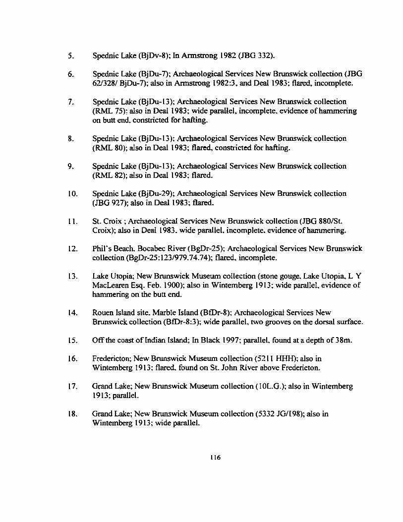
5. Spednic Lake (BjDv-8); In Armstrong 1982 (ffiG 332).
6. Spednic Lake (BjDu-7); Archaeological Services New Brunswick collection (ffiG 62/328/ BjDu-7); also in Armstrong 1982:3, and Deal 1983; flared. incomplete.
7. Spednic Lake (BjDu-13); Archaeological Services New Brunswick collection (RML 75); also in Deall983; wide parallel. incomplete. evidence ofhammering on butt end. constricted for hafting.
8. Spednic Lake (BjDu-13); Archaeological Services New Brunswick collection (RML 80); also in Deal 1983; flared. constricted for hafting.
9. Spednic Lake (BjDu-13); Archaeological Services New Brunswick collection (RML 82); also in Deal 1983; flared.
I 0. Spednic Lake (BjDu-29); Archaeological Services New Brunswick collection (JBG 927); also in Deal 1983; flared.
11. St. Croix ; Archaeological Services New Brunswick collection (JBG 880/St. Croix); also in Deal 1983. wide parallel, incomplete. evidence ofharnmering.
12. Phil's Beach. Bocabec River (BgDr-25); Archaeological Services New Brunswick collection (BgDr-25:123/979.74.74); flared. incomplete.
13. Lake Utopia; New Brunswick Museum collection (stone gouge. Lake Utopia. L Y MacLearen Esq. Feb. 1900); also in Wintemberg 1913; wide parallel, evidence of hammering on the butt end.
14. Rouen Island site, Marble Island (BfDr-8); Archaeological Services New Brunswick collection (BfDr-8:3); wide parallel, two grooves on the dorsal surface.
15. Off the coast of Indian Island; In Black 1997; paralleL found at a depth of 38m.
16. Fredericton; New Brunswick Museum collection (5211 HHH); also in Wintemberg 1913; flared. found on St. John River above Fredericton.
17. Grand Lake; New Brunswick Museum collection (lOL.G.); also in Wintemberg 1913; parallel.
18. Grand Lake; New Brunswick Museum collection (5332 JG/198); also in Wintemberg 1913; wide parallel.
116

19. Grand Lake; New Brunswick Museum collection (WM 14/20 I); also in Wintemberg 1913; flared.
20. Grand Lake; In Wintemberg 1913 (5332 J.G.); paralleL
21. Indian Point; New Brunswick Museum (D.B. 15/202/Indian Point. D. Balmaiq, Aug. 190 1 ); also in Wintemberg 1913; flared.
22. Indian Point; In Wintemberg 1913 (5340 D.B.); wide paralleL
23. French Lake; In Wintemberg 1913 ( 524 0/F. T .B.); parallel.
24. Jemseg; New Brunswick Museum collection (5407 WM); flared. incomplete.
25. Mouth of Jemseg; Archaeological Services New Brunswick collection (RPG 644); also in Wintemberg 1913; parallel.
26. Upper Jemseg; New Brunswick Museum collection (20.955/ Upper Jemseg, W.M.); flared. incomplete.
27. Big Lake Musquash; New Brunswick Museum collection (Big Lake Musquash/X8002-80FHS); flared. evidence of hammering on the butt end.
28. Westfield Beach; New Brunswick Museum collection (Westfield Beach. Mr. Samuel Lyons, Aug. 15 1896); also in Wintemberg 1913; parallel.
29. Richibucto River; New Brunswick Museum collection (32/285); also in Wintemberg 1913; parallel. has deep incised lines.
30. Wirrell. King's County; New Brunswick Museum collection (29615 Charles Perkins. Wirrell); wide parallel.
31. Nipisiquit River; In Wintemberg 1913; Accession 78 Cat. No. VII-D-1: parallel; I Yz miles above Bathurst.
32. River Philip; In Deal and Rutherford 1991; parallel.
33. Wentworth site (BkCv-3); In Deal 1996; Sunrise Trail Museum.
34. Scottsville, Margaree River; Nova Scotia Museum (26. 94.4/5925/Gouge. Scottsville. Inn. Co. N .S. ); also see Deal and Rutherford 1991; expanding parallel.
117

35. Enfield (BfLv-10); Nova Scotia Museum collection (4014/ 1/2 mile south of Enfield/1318); also see Preston 1974:24. and Deal and Rutherford 1991; wide parallel.
36. Grand Lake, King Farm (BfCv-17); Nova Scotia Museum collection (l/4.70); also in Piers 1895 :Figure 70, and Deal and Rutherford 1991; wide parallel. from the Charles Fairbanks collection.
37. Grand Lake, King Farm (BfCv-17); Nova Scotia Museum collection (07.4.68); also in Piers 1895 :Figure 68~ and Deal and Rutherford 1991; parallel, incomplete, from the Charles Fairbanks collection.
38. Grand Lake, King Farm (BfCv-17); Nova Scotia Museum collection (07.4.69); also in Piers 1895 :Figure 69 ~ and Deal and Rutherford 1991, parallel, from the Charles Fairbanks collection.
39. Wellington. Grand Lake (BfLv-17); Nova Scotia Museum collection (884/02.116/Wellington~ Grand lake, N.S.); parallel.
40. Grand Lake. King Farm (BfLv-17); In Piers 1895:Figure 56; also in Deal and Rutherford 1991; expanding parallel, incomplete. from the Charles Fairbanks collection.
41. Grand Lake. King Farm (BfCv-17); In Piers 1895:Figure 57; also in Deal and Rutherford 1991; wide parallel. from the Charles Fairbanks collection.
42. Grand Lake. King Farm (BfCv-17); In Piers 1895:Figure 58; also in Deal and Rutherford 1991; wide parallel, from the Charles Fairbanks collection.
43. Grand Lake, King Farm (BfCv-17); In Piers 1895:Figure 60; also in Deal and Rutherford 1991; parallel~ from the Charles Fairbanks collection.
44. Grand Lake. King Farm (BfCv-17); In Piers 1895 :Figure 66; Deal and Rutherford 1991; parallel, from the Charles Fairbanks collection.
45. Grand Lake, King Farm (BfCv-17); In Piers 1895:Figure 67; also in Deal and Rutherford 1991; parallel, from the Charles Fairbanks collection.
46. Grand Lake, King Farm (BfCv-17); In Piers 1895:Figure 71; also in Deal and Rutherford 1991 ; wide parallel, from the Charles Fairbanks collection.
118
47. Grand Lake. King Farm (BfCv-17); In Piers l895:Figure 72; also in Deal and Rutherford 1991 ~ wide parallel. incomplete. from the Charles Fairbanks collection.
48. Lake Thomas (BeCv-5); Nova Scotia Museum collection~ (32. 79174080); parallel. collected by Neil McQuarrie c. 1880. Lake Thomas. Halifax County.
49. Melanson; Nova Scotia Museum collection (73.180.430); parallel. incomplete.
50. Gaspereau Lake (BtDd-5); Gaspereau Lake site assemblage (BtDd-5:266); in Erskine 1967; parallel. incomplete.
51. Gaspereau Lake (BaDf-4); Jim Legge collection (BaDf-4); expanding, incomplete.
52. Gaspereau Lake (BaDf-4); Jim Legge collection (BaDf-4); paralleL
53. Gaspereau Lake (BaDf-4); Jim Legge collection (Bd.Df-4)~ flared. incomplete.
54. Gaspereau Lake (BaDf-4 ); In Deal and Rutherford 1991; also in Deal 1991, unable to locate in the Jim Legge collection.
55. Salmontail Lake; In Deal and Rutherford 1991: also in Deall99l; from the Jim Legge collection.
56. Salmontail Lake: In Deal and Rutherford 1991: also in Deal 1991; from the Derek Redden collection.
57. McGowen Lake (BeDg-2); St. Mary's University collection (BeDg-2:366); flared.
58. McGowen Lake (BeDg-2); St. Mary's University collection (BeDg-2: 278); parallel, incomplete.
59. Indian Gardens; Queen's County Museum collection (THR 27); wide parallel. incomplete.
60. Indian Gardens; Queen's County Museum collection (THR 25); paralleL
61. Indian Gardens (BaDg-2); Queen's Cowtty Museum collection (BaDg-2); wide parallel.
62. Indian Gardens (BaDg-2); In Kemp 1987:20 (THR 24).
63 . Indian Gardens (BaDg-2); In Deal and Rutherford 1991.
1 19

64. Indian Gardens, Low Terrace site (BaDg-2); In Kemp 1987 (BaDg-2:114); also see Deal and Rutherford 1991; flared.
65. Lake Rosignol, Mersey River (BaDf-5): Nova Scotia Museum collection (BaDf-5: 12): also in Myers 1973; paralleL
66. Lake Rosignol, Mersey River (BaDf-5); Nova Scotia Museum collection (BaDf-5: 11 ); also in Myers 1973: expanding parallel, evidence of hammering on the bun end.
67. Lake Rosignol (BaDh-2); Nova Scotia Museum collection (BaDh-2:8); also in Rosignol Survey 1985; parallel. incomplete.
68. Lake Rosignol (BaD h-I); Nova Scotia Museum collection (BaDh-I: 19); also in Rosignol Survey 1985; wide parallel. incomplete.
69. Lake Rosignol (BaDh-1 ); Nova Scotia Museum collection (BaDh-1 :5); also in Rosignol Survey 1985; wide paralleL
70. Lake Rosignol (BaDh-2): Nova Scotia Museum collection (BaDh-2:4); also in Rosignol Survey 1985; parallel, incomplete.
71. Lake Rosignol (BaDh-15); Nova Scotia Museum collection (BbDg-15:7); also in Rosignol Survey 1985: flared, incomplete.
72. Lake Rosignol (BaDg-2); In Rosignol Survey 1985 (BaDg-2: I 21 ); also see Deal and Rutherford 1991.
73. Shelburne River; Queen's County Museum collection (86:42:12); expanding parallel. incomplete. Shelburne River is possible location Inness 1997.
74. Shelburne River; Queen's County Museum collection (86:42:12); expanding parallel, incomplete. Shelburne River is possible location Inness l 997.
75. Barren Lake (AlDk-2/5); Yarmouth County Museum collection (WTS 370); parallel, provenience Powell 1997.
76. Eel Lake (BbDm-5); Nova Scotia Museum collection (BbDm-5:24); also in Davis 1991; flared; incomplete.
77. Clyde River, Shelburne County; In Piers 1911 :206; also in Deal and Rutherford 1991; found at a depth of 1 0 feet.
120
78. Montague PEl; Cunningham 1998: parallel.
79. No provenience~ Queen's County Museum collection; expanding parallel.
80. No provenience; Nova Scotia Museum collection; parallel.
81. No provenience; Nova Scotia Museum collection; parallel.
82. No provenience; Nova Scotia Museum collection; flared.
83. No provenience; Nova Scotia Museum collection (01186); flared. incomplete.
84. No provenience; Nova Scotia Museum collection (0.191 A); wide parallel.
85. No provenience; Nova Scotia Museum collection (3574/10.6); expanding parallel.
86. No provenience: Nova Scotia Museum collection; parallel. evidence of hammering on the butt end.
87. No provenience; Queen's County Museum collection (83-043.7); parallel. in-~omplete. evidence of hammering on the butt end.
88. No provenience~ Queen's County Museum collection (86.23); wide parallel. incomplete.
89. No provenience; Yarmouth County Museum collection: wide paralleL
90. No provenience; Yarmouth County Museum collection; wide parallel.
91. No provenience: Yarmouth County Museum collection: expanding parallel.
92. No provenience; New Brunswick Museum collection; (X8002.2); expanding parallel.
93. No provenience; Archaeological Services New Brunswick collection; expanding parallel.
94. No provenience; ln Wintemberg 1913 (33/2262 Gesner); wide parallel.
121

Ground Stone Rods (n= 21)
1. Eel Lake (BbDm-5); Nova Scotia Museum collection (BbDm-5:32); also in Davis 1991 :74; incomplete.
2. Eel Lake (BbDm-5); Davis 1991 :74; unable to locate artifact.
3. East Brook, Lake Rosignol (BbDg-12); In Rosignol Survey 1985 (BbDg-12:11); also in Deal and Rutherford 1991.
4. Cook's Falls, LaHave River; Nova Scotia Museum collection (00.10.9/Cook's Falls, LaHave River. Bridgewater); expanding head. complete. 275 mm long.
5. Sherbrook Lake (BeDd-1 ); Nova Scotia Museum collection {BeDd-1: 7); expanding head; incomplete.
6. Sherbrook Lake; Jim Legge collection; found near the head of the LaHave River.
7. Gaspereau Lake (BtDd-5); Gaspereau Lake site assemblage (BfDd-5:28); also in Erskine 1967.
8. Gaspereau Lake (BfDd-5); Gaspereau Lake site assemblage (BfDd-5:28); also in Erskine 196 7; preform?.
9. Upper Nine Mile Lake, Hants County; In Deal and Rutherford 1991; also in Preston 1991.
10. Maquapit Lake; New Brunswick Museum collection (slickstone/73/Maquapit Lake); incomplete.
11. Maquapit Lake; Archaeological Services New Brunswick collection (5184 DB); incomplete.
12. Indian Point Grand Lake; New Brunswick Museum collection (DB 979.62.28); incomplete, collector lived near L"ldian Point Laroque 1997.
13. Indian Point, Grand Lake; New Brunswick Museum collection (979.62.27 DB); incomplete, collector lived near Indian Point Laroque 1997.
14. Portobelo; New Brunswick Museum collection {5335); incomplete.
121

15. Jemseg (BkDm-14); Archaeological Services New Brunswick collection (BkDm-14:783); incomplete. found in test pit 1 Jeandron 1997.
16. Phil"s Beach. Bocabec River (BgDr-25); Archaeological Services New Brunswick collection (BgDr-25:3/74/battered slickstone); incomplete.
17. Spednic Lake (BjDu-7); Archaeological Services New Brunswick collection (JBG: 375); also see Armstrong 82:7. and Deal 1983; complete. both ends taper to points.
18. Spednic Lake (BjDu-1 0); In Armstrong 1982:7 (JBG 427); also in Deal 1983: both ends taper to points. unable to locate this artifact.
19. Wabski; New Brunswick Museum collection (44.41 ETA); incomplete. from site W-1.
20. No provenience: Yarmouth County Museum (WTS 635); incomplete.
21. No provenience; Davis 1997 (WTS 688); rod in the Wilbur Sollows collection.
1., ... _ _,

Allan. P. 1981
1983
Amos. C. L. 1978
Armstrong. B.
REFERENCES CITED
The Oxbow Site: Chronology and Prehistory in Northeastern New Brunswick. New Brunswick Manuscripts in Archaeology Series 2. Historical Resources Administration. Fredericton. The St. Croix Waterway Recreation Area /982 Archaeological Survey. Manuscripts in Archaeology Number 3. New Brunswick Historical and Cultural Resources, Fredericton.
Post-Glacial Evolution of the Minas Basin: A Sedimentological Approach. Journal of Sedentary Petrology 48:965-982.
1982 An Artifact Analysis of the JBG Collection. Unpublished Honours Essay, Department of Anthropology. University ofNew Brunswick. Fredericton.
Bird. J. B. 1980
Black. D. W. 1997
Bolian. C. E. 1980
The Natural Landscapes of Canada. 2nd edition. John Wiley and Sons. Toronto.
A Native Artifact from the Ocean Floor near Indian Island. Fieldnotes: The Newsletter of the New Brunswick Archaeological Society. Volume 3 (2):5-7.
The Early and Middle Archaic of the Lakes Region. New Hampshire. In Early and i'vfiddle Archaic Cultures in the Northeast, edited by D. Starbuck and C. Bolian. pp. 115-134. Occasional Publications in Northeastern Anthropology #7.
Bonnichsen. R., D. L. Keenlyside, and K. L. Turnmire 1991 Paleoindian Patterns in Maine and the Maritimes. In Prehistoric
Archaeology in the Maritime Provinces: Past and Present Research. edited by M. Deal and S. Blair. pp. 1-36. Reports in Archaeology Number 8, The Council of Maritime Premiers Maritime Committee on Archaeological Cooperation. Fredericton.
124

Bourque, B. 1. 1995 Diversity and Complexity in Prehistoric Maritime Societies: A Gulf of
Maine Perspective. Plenum Press. New York.
Bradstree4 T. E .• and R. B. Davis 1975 Mid Post-Glacial Environments in New England with an Emphasis on
Maine. Arctic Anthropology 12(2): 7-22.
Brose, D. S., and N. Greber 1982 The Ringler Archaic Dugout from Savannah Lake, Ashland County. Ohio:
Bunker, V.
With Speculations on Trade and Transmission in the Prehistory of the Eastern United States. Mid-Continental Journal of Archaeology 7(2):245-282.
1992 Stratified Component of the Gulf of Maine Archaic Tradition at the Eddy Site. Amoskeag Falls. In Early Holocene Occupation in Northern New England. edited by B. Robinson. J. Petersen and A. Robinson. pp. 135-148. Occasional Publications in Maine Archaeology, Number 9. Maine Historic Preservation Commission, Augusta.
Butzer. K. W. 1982 Archaeology as Human Ecology. Cambridge University Press. Cambridge.
Christianson. D. 1985 Archaeology and Lake RossignoL t\1/ersey Quarterly. (Winter):S-9.
Clark, J. A., W. E. Farrell. and W. R. Peltier 1978 Global Changes in Post-Glacial Sea Level: A Numerical Calculation.
Quaternary Research 9:265-287.
Connigham. R. C. 1998 Personal communication concerning a full-channeled gouge found on
Prince Edward Island. Fredericton.
Cox, S. L. 1991 Site 95.20 and the Vergennes Phase in Maine. Archaeology of Eastern
North America 19:135-161.
Crock, J. G .• J. B. Petersen. and R. M. Anderson 1993 Scalloping for Artifacts: A Biface and Plummet from Eastern Blue Hill
Bay, Maine. Archaeology of Eastern North America 21:179-192.
125

Davis. M. B. 1969 Climatic Changes in Southern Connecticut Recorded by Pollen Deposits at
Rogers Lake. Ecology 50:409-422.
Davis, R. B.. and G. L. Jacobson 1985 Late Glacial and Early Holocene Landscapes in Northern New England
and Adjacent Areas ofCanada. Quaternary Research 23:341-368.
Davis. S. A. 1991
1997
Yannouth County Survey. In Archaeology in Nova Scotia /987 and /988. edited by S. Davis, C. Lindsay, R. Olgovie. and B. Preston. pp. 69-88. Nova Scotia Museum Curatorial Report 69, Halifa"<. Personal communication concerning artifacts from Nova Scotia. Halifax.
Davis. S. A .• and D. Christianson 1988 Three Paleo-Indian Specimens from Nova Scotia. Canadian Journal of
Archaeology 12:190-196.
Deal. M. 1983
1984
1986
1991
1996
Notes on Collections from Spednic Lake. Unpublished Manuscript on file at Memorial University ofNewfoundland. St. John's. The Archaeological Significance ofthe Chiputneticook-St. Croix Drainage System. Manuscript on file, Memorial University ofNewfoundland, St. John's. Late Archaic and Ceramic Period Utilization of the Mud Lake Stream Site, Southwestern New Brunswick. Man in the Northeast 32:67-94. The Minas Basin Archaeological Project: Reports for 1988-1991. Nova Scotia Museum, Curatorial Report, in preparation. Western North Shore Survey 1991: Archaeology of Tatamagouche Bay and Vicinity. In Archaeology in Nova Scotia /99/, edited by S. Powell. Nova Scotia Museum Curatorial Reports Number 81, Halifax.
Deal, M. and D. E. Rutherford 1991 The Distribution and Diversity ofNova Scotian Archaic Sites and
Materials: A Re-Examination. Paper presented to the Canadian · Archaeology Association Meeting. St. John's.
Deevey, E. S. 1951 Late-Glacial and Postglacial Pollen Diagrams from Maine. American
Journal ofScience 249:177-207.
126

Dincauze, D. F. 1971 An Archaic Sequence for Southern New England. American Antiquity 36
(2): 194-198. 1976 The Neville Site: 8000 Years at Amosiceag. Peabody Museum Monographs
#4. Harvard University, Cambridge. 1987 Strategies for Palaeoenvironmental Reconstruction in Archaeology.
Advances in Archaeology Method and Theory 11:255-336.
Dincauze, D. F .. and M. T. Mullholland 1977 Early and Middle Site Distribution and Habitats in Southern New
England. In Amerinds and their Paleoenvironments in Northeastern North America, edited by W. Newman and B. Salwen. pp. 439-456. Annals of the New York Academy of Science 288.
Doyle, R. A., N.D. Hamilton. J. B. Peterse~ and D. Sanger 1985 Late Paleo-Indian Remains from Maine and their Correlation in
Northeastern Prehistory. Archaeology of Eastern North America 13: 1-34.
Erskine, J. S. 1964 Nova Scotia Prehistory. Dalhousie Review (Spring):l6-27. 1967 Gaspereau Lake Site. Kings County, Nova Scotia. Ms. on file. Memorial
University ofNewfoundland, St. John' s. 1969 Early Cultures ofNova Scotia, Part I. A Preliminary Prehistory. Nova
Scotia Journal of Education 18:19-26, Halifax. 1998 lvfemoirs on the Prehistory of Nova Scotia 1957-1967. Edited by M.
Deal, Nova Scotia Museum Special Report, Halifax.
Erwin.J. C. 1995 An Intrasite Analysis ofPhillip's Garden: A Middle Dorset Palaeo-Eskimo
Site at Port au Choix. Newfoundland. Unpublished M.A. Thesis, Department of Anthropology. Memorial University ofNewfound1and, St. John' s.
Fitting, J. E. 1968 Environmental Potential and the Postglacial Readaptation in Eastern
North America American Antiquity 33(4):441-445.
Flint, R. F., and E. S. Deevey 1951 Radiocarbon Dating of Late-Pleistocene Events. American Journal of
Science 249:257-300.
127

Fog4 L. M. 1998 The Examination and Analysis of a Dorset Palaeoeski.mo Dwelling at
Cape Ray, Newfoundland. Unpublished M.A. Thesis. Department of Anthropology. Memorial University ofNewfoundland. St. John's.
Funk. R. E., and B. Wellman 1984 Evidence of Early Holocene Occupation in the Upper Susquehanna
Valley. New York State. Archaeology of Eastern North America 12:81-109.
Grant. D. R. 1970 Recent Coastal Submergence of the Maritime Provinces. Canada
Canadian Journal of Earth Sciences 7:676-689. 1975 Recent Coastal Submergence of the Maritime Provinces. Proceedings of
the Nova Scotia Institute of Science. 27, Supplement 3:83-102. Halifax.
Hadden. K. A. 1975 A Pollen Diagram from a Postglacial Peat Bog in Hants County. Nova
Scotia. Canadian Journal of Botany 53:39-47.
Inness. V. 1997 Personal communication concerning artifacts in the collections at the
Queen· s County Museum. Liverpool.
Jendron. J. 1997 Personal communication concerning artifacts from the Jemseg
Archaeological Project, Fredericton.
Kemp. D. 1987 Groundstone Analysis: Low Terrace and Raddall Collections. In
Archaeological Investigations at the Low Terrace site (BaDg-2) Indian Gardens, Queen's County, Nova Scotia by M. Deal, J. Corkum, D. Kemp, J. McClair, S. Mcllquam, A. Murchison. and B. Wells. Nova Scotia •'-'fuseum Curatorial Report 63: 201-213.
128

Keenlyside. D. L 1983 In Search of the Island's First People. The Island Magazine 13:3-7. l984a Ulus and Spearpoints: Two New Archaeological Finds from Prince
Edward Island. The Island Magazine 16:25-27. 1984b The Prehistory of the Maritimes: Canada's Visual History Volume 65.
National Museum of Man and the National Film Board of Canad~ Ottawa.
1985a Late Palaeo-Indian Evidence from the Southern Gulf of St. Lawrence. Archaeology of Eastern North America 13:79-92.
1985b La Peri ode Paleoindienne sur L 'lle-Du-Prince-Edouard. Recherches Amerindiennes au Quebec XV:119-126.
1991 Paleoindian Occupation of the Maritimes Region of Canada. In Clovis:
Kellogg, D. C.
Origins and Adaptations. edited by R. Bonnicbsen and K. Turnmire. pp.l63-l 73. Peopling of the Americas Publications. Center for the Study of the First Americans, Oregon State University.
1988 Problems in the use of Sea-Level Data for Archaeological Reconstructions. In Holocene Ecology in Northeastern North America, edited by G. Nicholas, pp.81-104. Plenum Press, New York.
LeBlanc. S. 1996 A Place With a View: Grosswater Subsistence-Settlement Patterns in the
Gulf of St. Lawrence. Unpublished M.A. Thesis, Department of Anthropology, Memorial University ofNewfoundland. St. John·s.
Laroque. P. 1997 Personal communication concerning artifacts in the New Brunswick
Museum collections, Fredericton.
Livingstone. D. A. 1968 Some Interstadial and Postglacial Pollen Diagrams from Eastern Canada.
Ecological Monographs 38:87-125.
Livingstone, D. A., and A. H. Estes 1967 A Carbon-Dated Pollen Diagram from the Cape Breton Plateau, Nova
Scotia. Canadian Journal of Botany 45:339-359.
Livingstone, D. A .• and B. G. R. Livingstone 1958 Late-Glacial and Postglacial Vegetation from Gillis Lake in Richmond
County, Cape Breton, Nova Scotia. American Journal of Science 256:341-355.
129

MacDonald G. F. 1968 Debert: A Palaeo-Indian Site in Central Nova Scotia. Anthropology
Papers of the National Museum of Canada No. 16, Ottawa.
Marshall. H. 1942 Some Ancient Indian Village Sites Adjacent to Manchester. New
Hampshire. American Antiquity 7:358-363.
Maymon. J. H .• and C. E. Bolian 1992 The Wadleigh Falls Site: An Early and Middle Archaic Period Site in
Southeastern New Hampshire. In Early Holocene Occupation in Northern New England, edited by B. Robinson. J. Petersen and A. Robinson. pp. 117-134. Occasional Publications in Maine Archaeology, Number 9. Maine Historic Preservation Commission. Augusta.
McGhee. R., and J. A. Tuck 1975 An Archaic Sequence from the Strait of Belle Isle. Labrador. Mercury
Series No. 34. National Museum ofMan, Ottawa.
Mott. R. J. 1975a Post-Glacial History and Environments in Southwestern New Brunswick.
Proceedings of the Nova Scotia Institute ofScience 27. Supplement 3:67-82.
l975b Palynological Studies of Lake Sediments Profiles from Southwestern New Brunswick. Canadian Journal of Earth Science 12:273-288.
Murphy, B. M .• and D. W. Black 1996 Zooarchaeology in the Canadian Maritimes. Canadian Zooarchaeology
9:2-20.
Murray, M. S. 1992 Beyound the Laundry List: The Analysis of Faunal Remains from a Dorset
Dwelling at Phillip•s Garden (EeBi-1), Port au Choix. Unpublished M.A. Thesis, Department of Anthropology. Memorial University of Newfoundland, St. John's.
Myers., H. B. 1973 Archaeological Survey of Kejimkujik National Park. Nova Scotia /972.
Parks Canada, Manuscript Report Series 1 06, Ottawa.
130

Petersen. J. B. 1986 A Late Pleistocene and Holocene Archaeological Sequence in Central
Maine. Cu"ent Research in the Pleistocene 3:16-19. 1991 Archaeological Testing at the Sharrow Site: A Deeply Stratified Early to
Late Holocene Cultural Sequence in Central ;~aine. Occasional Publications in Maine Archaeology. Number 8. Maine Historic Preservation Commission~ Augusta.
1995 Preceramic Archaeological Manifestations in The Far Northeast: A Review of Recent Research. Archaeology of Eastern North America 23:207-230.
Petersen. J. B. and N. Asch Sidell 1996 Mid-Holocene Evidence of cucurbita sp. From Central Maine. American
Antiquity 61 ( 4 ):685-698.
Petersen. J. B., T. R. Baker, and M. J. Heckenberger 1988 A Stratigraphic Sequence at the Sharrow Site in Central Maine. Cu"enr
Research in the Pleistocene 5:19-20.
Petersen. J. B .. N.D. Hamilton, D. E. Putnam, A. E. Spiess. R. Stuckenrath. C. A. Thayer. and 1. A. Wolford
1986 The Piscataquis Archaeological Project: A Late Pleistocene and Holocene Occupational Sequence in Northern New England. Archaeology of Eastern North America 14:1-18.
Petersen, J. B., and D. E. Putnam 1987 Another Holocene Sequence and Recent Progress of the Piscataquis
Archaeological Project in Central Maine. Cu"enr Research in the Pleistocene 4:23-24.
1992 Early Holocene Occupation in the Central Gulf of Maine Region. In Early Holocene Occupation in Northern New England. edited by B.
Piers, H.
Robinson, J. Petersen and A. Robinson, pp. 13-62. Occasional Publications in Maine Archaeology, Number 9. Maine Historic Preservation Commission. Augusta.
1895 Relics of the Stone Age in Nova Scotia. Transactions of the Nova Scotia Institute of Natural Science 9:26-58.
1911 Provincial Museum and Science Library. In Province of Nova Scotia. Report of the Department of Mines 1910, pp. 194-220. Kings Printer, Halifax.
131

Powell. S. 1997 Personal communication concerning artifacts in the Nova Scotia
Museum's collections. Halifax.
Preston, B. W. 1974 An Archaeological Survey of the Shubenacadie River System 1970. Nova
Scotia Curatorial Report 18, Halifax. 1991 Notes on Archaic Materials reported to, or found in the Nova Scotia
Museum Collection. Ms. on file, Archaeology Unit. Memorial University ofNewfoundland, St. John's.
Putnam. D. E. 1994 Vertical Accretion ofFlood Deposits and Deeply Stratified Archaeological
Site Formation in Central Maine. USA. Geoarchaeology: An International Journal9(6):467-502.
Quinlan. G .. and C. Beaumont 1981 A Comparison of Observed and Theoretical Postglacial Sea Level in
Atlantic Canada. Canadian Journal of Earth Sciences 18: 1 146-1163.
Renouf. M.A. P. 1977 A Late Paleo indian and Early Archaic Sequence in Southwestern
Labrador. Man in the Northeast 13:35-44. 1993 Palaeoeskimo Seal Hunters at Port au Choix. Northwestern
Newfoundland. Newfoundland Studies 9(2): 185-212.
Ritchie, W. A. 1961 A Typology and Nomenclature for New York Projectile Points. New York
State Museum and Science Service, Bulletin 384. University of the State ofNew York, Albany.
1965 The Archaeology of New York State. Natural History Press, New York. 1968 The RI Site, The Vergennes Phase and the Laurentian Tradition. New York
State Archaeological Association Bulletin 42:1-5. 1980 The Archaeology of New York State (revised edition). Harbour Hill, New
York. 1985 Fifty Years of Archaeology in the Northeastern United States: A
Retrospect. American Antiquity 50(2):412-420.
1 ... ., ~-
Robinson. B. S. 1987 Middle Archaic Mortuary Evidence and a Proposed Chronological
Sequence for the Northeast and Coastal Archaic Tradition. Unpublished M.A. Paper. Department of Anthropology, Brown University. Providence.
1992 Early and Middle Archaic Period Occupation in the Gulf of Maine Region: Mortuary and Technological Patterning. In Early Holocene Occupation in Northern New England, edited by B. Robinson. J. Petersen and A. Robinson. pp. 63-116. Occasional Publications in Maine Archaeology, Number 9. Maine Historic Preservation Commission. Auglb-ta.
1996 A Regional Analysis ofthe Moorehead Tradition: 8500-3700 B.P. Archaeology of Eastern North America 24:95-148.
Robinson. B.S., J. B. Petersen. and A. K. Robinson 1992 Early Holocene Occupation in Northern New England. Occasional
Publications in Maine Archaeology# 9. Maine Historic Preservation Commission, Augusta
Rossignol Survey 1985 Nova Scotia Museum Archaeological Specimen Records for the 1985
Survey of Lake Rossignol. Ms. on file, History Section. Nova Scotia Museum. Halifax.
Sanger. D. 1973
1975
1979
1988
1996
Cow Point: An Archaic Cemetery in New Brunswick. National Museum of Man. Archaeological Survey of Canada. Mercury Series. Paper 12. Ottawa Cultural Change as an Adaptive Process in the Maine-Maritimes Region. Arctic Anthropology 12(2):60-75. Some Thoughts on the Scarcity of Archaeological Sites in Maine Between 10,000 and 5,000 years ago. In Discovering Maine's Archaeological Heritage, edited by D. Sanger, pp. 23-34. Maine Historical Preservation Commission, Augusta. Maritime Adaptation in the Gulf of Maine. Archaeology of Eastern North America 16:81-89. Gillman Falls Site: Implications for the Early and Middle Archaic of the Maritime Peninsula. Canadian Journal of Archaeology 20:7-28.
133

Sanger. D .• W. R. Belcher. and D. C. Kellogg 1992 Early Holocene Occupation at the Blackman Stream Site. Central Maine.
In Early Holocene Occupation in Northern New England, edited by B. Robinson. J. Petersen and A. Robinson. pp. 149-162. Occasional Publications in Maine Archaeology. Number 9. Maine Historic Preservation Commission. Augusta.
Sanger. D., R. B. Davis, R. G. MacKay, and H. W. Borns 1977 The Hirundo Archaeological Project - An Interdisciplinary Approach to
Central Maine Prehistory. InAmerinds and their Paleoenvironments in Northeastern North America, edited by W. Newman and B. Salwen.. pp. 457-471. Annals of the New York Academy of Sciences 288.
Sanger, D .• and S. A. Davis 1991 Preliminary Report on the Bain Site and the Chegoggin Archaeological
Project. In Prehistoric Archaeology in the Maritime Provinces: Past and Present Research~ edited by M. Deal and S. Blair, pp. 67-79. Reports in Archaeology Number 8. The Council of Maritime Premiers Maritime Committee on Archaeological Cooperation. Fredericton.
Sergeant, D. E. 1991 Harp Seal. Man and Ice. Canadian Special Publication of Fisheries and
Aquatic Sciences 114.
Schofield, W. B .• and H. Robinson 1960 Late-Glacial and Postglacial Plant Macrofossils from Gillis Lake.
Richmond County, Nova Scotia. American Journal of Science 258:518-523.
Sco~ D. B .. and D. A. Greenberg 1983 Relative Sea Level Rise and Tidal Development in the Fundy Tidal
System. Canadian Journal of Earth Sciences 20:1554-1564.
Shaw. J., R. B. Taylor. and D. L. Forbes 1993. Impact ofthe Holocene Transgression on the Atlantic Coastline ofNova
Scotia. Geographie physique et Quaternaire 4 7 (2):221-238.
Snow, D. R. 1980 The Archaeology of New England. Academic Press, New York.
134

Spiess. A. E. 1992 Archaic Period Subsistence in New England and the Atlantic Provinces. In
Early Holocene Occupation in Northern New England. edited by B. Robinson. 1. Petersen and A. Robinson. pp. 163-186. Occasional Publications in Maine Archaeology. Number 9. Maine Historic Preservation Commission. Augusta.
Spiess. A. E .• B. J. Bourque. and R. M. Gramly 1983 Early and Middle Archaic Site Distribution in Western Maine. North
American Archaeologist 4(3):225-244.
Stea. R. R .• and R. J. Mott 1989 Deglaciation Environments and Evidence for Glaciers of Younger Dryers
Age in Nova Scotia. Canada Boreas 18:169-187.
Stright. M. 1990 Archaeological Sites on the North American Continental Shelf.
Geological Society of America Centennial Special Volume 4. pp. 439-465.
Terrasmae. J. 1973 Notes on the Late \Visconsian and Early Holocene History of Vegetation
of Canada. Arctic:. and Alpine Research 5 (3):201-222.
Tuck. J. A. 1975
1984 1991
The Northeastern Maritime Continuum: 8000 Years of Cultural Development in the Far Northeast. Arctic Anthropology 12(2):139-147. Afaritime Provinces Prehistory. National Museum of Man. Ottawa. The Archaic Period in the Maritime Provinces. In Prehistoric Archaeology in the Maritime Provinces: Past and Present Research. edited by M. Deal and S. Blair. pp. 37-65. Reports in Archaeology Number 8. The Council of Maritime Premiers Maritime Committee on Archaeological Cooperation. Fredericton.
Turnbaugh. W. A. 1975 Towards and Explanation ofthe Broadspear Dispersal in Eastern North
American Prehistory. Journal of Anthropological Research 3( 1 ):51-68. 1977 An Archaeological Prospect of the Ulu or Semi-Lunar knife in
Northeastern North America. Archaeology of Eastern North America 5:86-94.
135

Turnbull. C. J. 1988 Reflections on a Ground Slate Bayonet from the Tantramar Marsh. Upper
Bay of Fundy. Canadian Journal of Archaeology 12:87-107.
Turnbull. C. J., and D. W. Black 1988 The Slate Ulu from White Horse Island. In Bliss Revisited: Preliminary
Accounts of the Bliss Islands Archaeology Project, Phase IL edited by D. Black. pp.73-79. New Brunswick Manuscripts in Archaeology #24. Fredericton.
Vanicek. P. 1976 Pattern of Recent Vertical Crustal Movement in Maritime Canada.
Canadian Journal of Earth Science 13:661-667.
Wintemberg, W. J. 1913 Untitled- Gouges; Stone Gouges-Volume Vffi-New Brunswick, Nova
Scotia. Cape Breton .... MCC/CMC Archives Docs. Archeo. Box 80, File. Unpublished Document on file at the Canadian Museum of Civilization. Hull.
Yesner. D. R .• N. D. Hamilton, and R. A. Doyle 1983 ·•Landlocked,. Salmon and Early Holocene Lacustrine Adaptation in
Southwestern Maine. North American Archaeologist 4(4):307-333.
Way, D. S. 1973 Te"ain Analysis: A Guide to Site Selection Using Aerial Photographic
Interpretation. Dowden, Hutchinson and Ross Inc. Stroudburg, Pennsylvania.
136


I
(
