chaffee county comprehensive plan · chaffee county comprehensive plan chaffee county, colorado...
TRANSCRIPT
MARCH 2000
CHAFFEE COUNTY
COMPREHENSIVE PLAN
CHAFFEE COUNTY
COMPREHENSIVE PLAN
CONSENSUS
PLANNING, INC.
Chaffee County Comprehensive Plan
CHAFFEE COUNTY
COMPREHENSIVE PLAN
CHAFFEE COUNTY, COLORADO
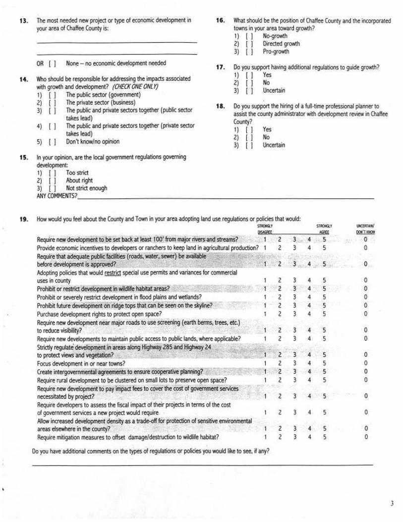
Prepared For:
Chaffee County
104 Crestone Avenue
P.O. Box 699
Salida, Colorado 81201
Chaffee County Commission
Frank McMurry, Chairman
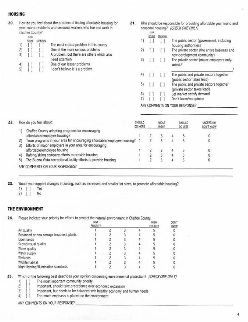
Jim Thompson
Glenn Everett
Chaffee County Planning Commission
Dave Dickerson, Chairman
Sherry Johnson
Jacob Lofgren
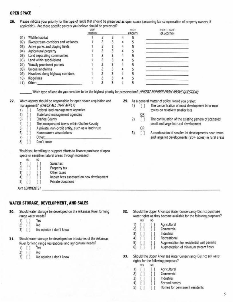
Ted Richardson
Jerry Steinauer
Frank Thomas
Fred Rasmussen
Lloyd Johnson
Will Thomas
Ron Newman, Planning Consultant
Thomas H. Hale, County Administrator
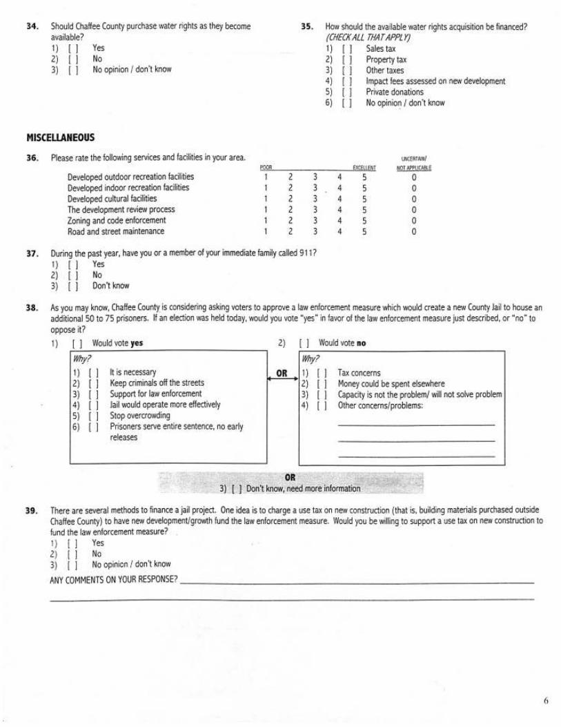
Kathy Leinz, Administrative Assistant
Final Plan Prepared By:
Consensus Planning, Inc.
924 Park Avenue SW
Albuquerque, New Mexico 87102
(505) 764-9801
Draft Plan Prepared By:
Clarion Associates, Denver
RNL Design, Denver
Colorado Open Lands
RRC Associates
Thomas Niver
Chaffee County Comprehensive Plan
TABLE OF CONTENTS
Section
1. EXECUTIVE SUMMARY
2. INTRODUCTION
3. EXISTING CONDITIONS: A SNAPSHOT OF CHAFFEE
COUNTY
4. LAND USE AND DEVELOPMENT PATTERNS
5. COMMUNITY CHARACTER/NATURAL/CULTURAL
RESOURCES
6. TRANSPORTATION
7. AFFORDABLE HOUSING
8. COMMUNITY FACILITIES/FINANCING
9. ECONOMIC DEVELOPMENT
ACTION AGENDA
GLOSSARY OF TERMS
IMPLEMENTATION ACTION SUMMARY
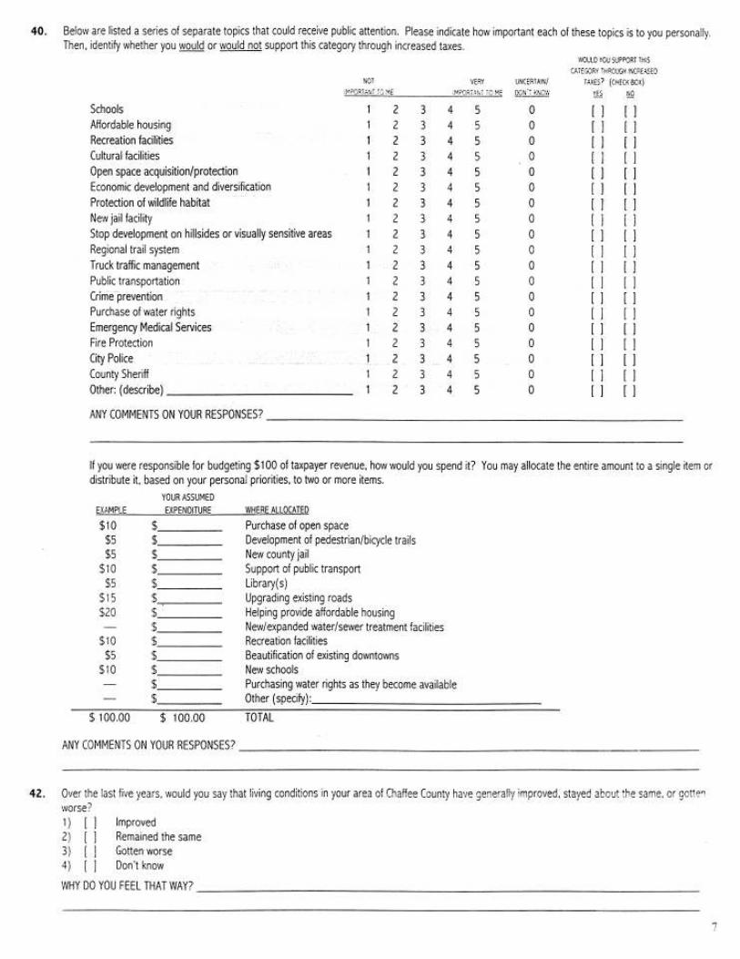
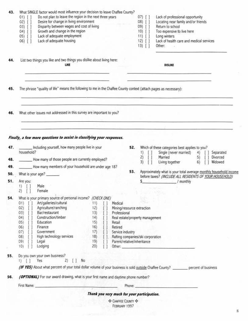
APPENDIX A: SURVEY SUMMARY
APPENDIX B: SURVEY INSTRUMENT
APPENDIX C: ALTERNATIVE DEVELOPMENT SCENARIO
MATRIX
APPENDIX D: INFRASTRUCTURE AVAILABILITY
SUMMARY
1
5
9
27
33
41
43
45
47
49
51
53
Page
Chaffee County Comprehensive Plan 1
1. EXECUTIVE SUMMARY
The Chaffee County Comprehensive Plan was based on extensive anddiverse public participation from residents throughout the County. TheChaffee County Comprehensive Plan was initiated to address several fac-tors concerning growth and development taking place throughout theCounty. All of these factors and concerns led the Chaffee County Boardof County Commissioners in late 1996 to commission a new comprehen-sive land use plan for Chaffee County. Typically, comprehensive plansare updated every five to ten years, but Chaffee County’s plan dated from1971. This is not all that surprising given the lack of growth in the countyduring the 1980s. Clearly, the 1971 plan was out-of-date. For example,it foresaw a county population of only 11,000 by 1990. Today, thecounty’s population is over 15,000, and conservative estimates are thatthe county will have over 25,000 people by the year 2020. These num-bers do not include seasonal residents who own second homes or tour-ists. Moreover, the county’s zoning, subdivision, and other land devel-opment codes are also dated. The subdivision regulations were last com-prehensively revised in 1979. Many tools that are currently being usedby other jurisdictions in Colorado are not included in any of the county’sland development regulations.
With financial support from the State of Colorado Department of LocalAffairs and Great Outdoors Colorado, the county conducted a competi-tive search process and in late 1996 selected a consulting team led byClarion Associates and RNL Design of Denver to assist in preparation ofthe plan. At the same time, the county commissioners appointed a broad-based plan oversight committee to work closely with the consulting teamand act as a sounding board throughout the planning process. The com-mittee included representatives from the ranching community, businesses,environmental interests, state and federal agencies, the towns, and oth-ers. Following the preparation of the draft plan in 1998, The Countyhired Consensus Planning, Inc. to assist in revising the draft for adoption.
In brief, the project goals were to:
· Work with citizens to develop a long-range vision for the county andproduce key goals and objectives to guide future growth;
· Generate alternative growth scenarios and evaluate the likely impactson development patterns; and
· Identify and discuss appropriate policies and tools to implement thecomprehensive plan.
The Planning Process addressed the following planning areas:
· Economic/demographic trends community character;· Infrastructure and government services;· Natural and cultural resources;· Open space;· Housing; and· Intergovernmental policies.
Chaffee County Comprehensive Plan2
The project kick-off meeting with the oversight committee took place inJanuary 1997 followed by a series of county-wide meetings in March.The public planning process concluded with a major county-wide imple-mentation workshop in November 1997.
This plan was considered officially by the county planning commissionduring 1998 and 1999 at a series of informal workshops and formal pub-lic hearings in accordance with state statutes. Under Colorado law, theComprehensive Plan is an advisory document and is not regulatory innature. Its importance is to provide the policies needed to guide updatesto Chaffee County’s development regulations. For the plan to becomereality, the county will need to adopt a variety of regulatory (e.g., newzoning provisions) and non-regulatory tools (e.g., cluster developmentincentives).
This plan is designed to be used in conjunction with other county andtown planning documents. It is an important tool in helping citizenscontrol their future. More specifically, it is designed to serve as a guidefor revising local development regulations and review processes, review-ing development and annexation proposals, and making local infrastruc-ture investment decisions.
Following adoption of the plan, it will be important to establish a processthat assists the County in implementing the plan in a timely fashion, withannual check points to gauge progress in completing the specific actionitems recommended in the plan. The plan includes an “Action Agenda”that summarizes the key activities necessary to implement the plan andan index of specific implementation recommendations. It will also bevital to update the plan periodically, its underlying assumptions, and theaction elements to ensure that the plan does not become outdated orirrelevant in the face of changing economic and demographic forces.
Chaffee County Comprehensive Land Use and Open Space Plan
Key Goals and Objectives
A. Target most new residential and commercial development to smallerlots (1acre or less) in and around existing communities. Allow onlylarger lot zoning in rural areas.
B. Improve county land use regulations to protect air/water quality, sce-nic areas, historic and cultural resources, and wildlife habitat. Besensitive to private property rights.
C. Use incentives as well as regulations to help protect river corridors,wildlife habitat, agricultural lands, and ranching.
D. Maintain existing public access to state and federal lands, includingriver corridors.
E. Minimize the tax burden on citizens. Require development to assessimpacts on public facilities and to pay fair share of costs for necessaryservices.
Chaffee County Comprehensive Plan 3
F. Promote economic diversity and economic development based onpassive recreation, ranching/agriculture, and “light” industry to lessenthe gap between incomes and cost of living in the county.
G. Ensure that water supply and infrastructure service policies are in ac-cord with the adopted county comprehensive plan. Give priorityservice to focused residential and commercial development.
H. In spending ‘tax dollars, give priority to schools, upgrading existingroads, open space development rights purchase, and new water/sewerfacilities. Except for schools, little sentiment for new taxes to financethese facilities and services.
I. The private sector (particularly large employers), with cooperationfrom local governments, should take the lead to promote affordablehousing opportunities through market mechanisms.
J. Provide a safe and efficient transportation system for all county resi-dents.
The Preferred Scenario in Brief
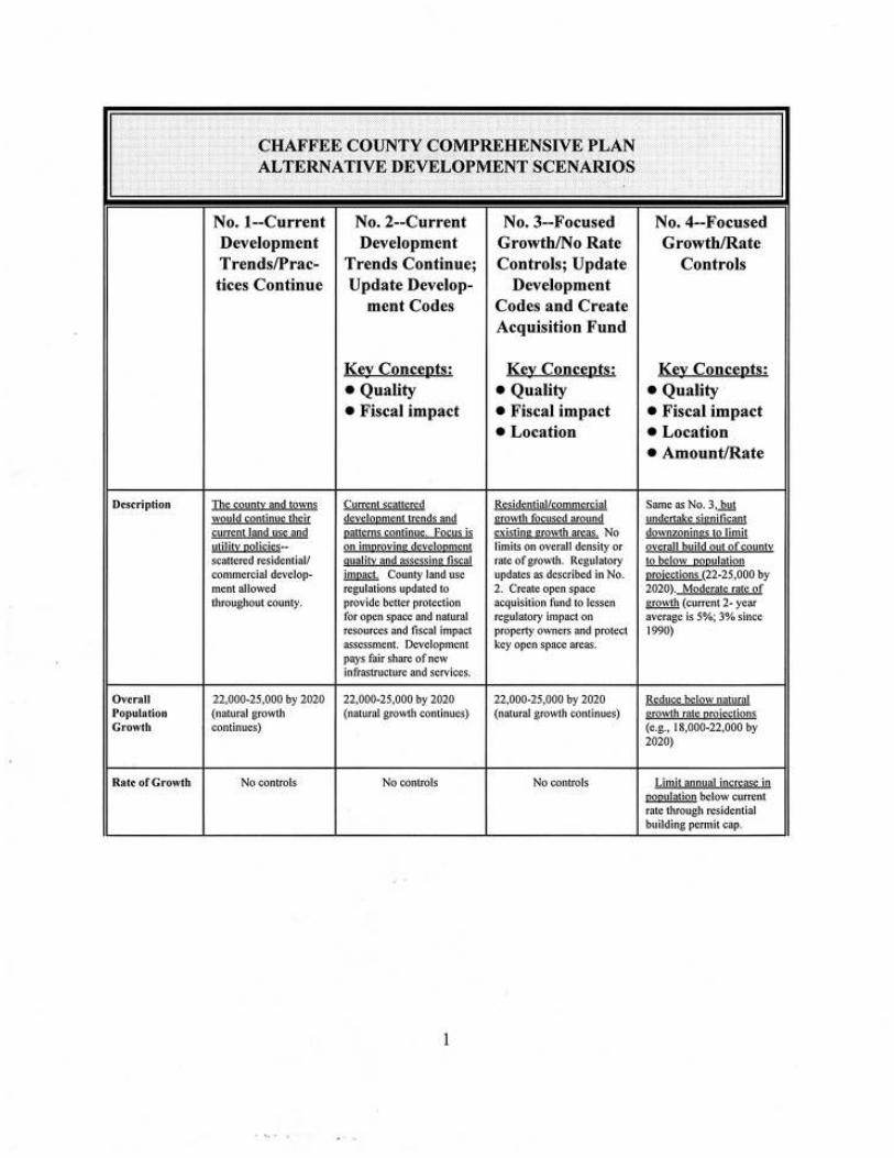
Based on the refined goals and objectives that emerged from the commu-nity workshops and public opinion survey, four alternative developmentscenarios were presented to county residents for their consideration. (Thesescenarios are set forth in Appendix C).
Scenario 3 most closely tracked the goals and objectives, as well as theresults of the survey. This fact was confirmed by citizens who attendedthe alternative development scenario workshops or submitted written com-ments. A significant majority favored Development Scenario 3, but therewas a strong desire to add certain features of Scenarios 2 and 4 (describedbelow).
Under the preferred scenario, population growth would continue, butresidential and commercial development would be focused around exist-ing communities, in other words, the county would encourage smallerlot residential development in and around Salida, Buena Vista, and PonchaSprings. The County would work closely with these jurisdictions to achievethis. Other unincorporated areas that have already seen developmentlike Nathrop town site, Mesa Antero, and Game Trail could also receiveadditional growth if infrastructure was available to accommodate it. Thecounty and towns should improve their subdivision and zoning standardsto ensure that this focused development was compatible with existingresidential neighborhoods and that it retained a small-town character.Regulations and incentives would be used to improve the quality andamount of open space in and around rural residential projects.
Similarly, the plan discourages scattered commercial development out-side of the towns as is now often done through a special permit process,except in limited instances (e.g., logging, lodges, and similar uses that
Chaffee County Comprehensive Plan4
require a rural location). Signage and landscaping standards would beapplied to ensure that this development maintained the attractive charac-ter of existing communities.
The plan provides support for the creation of a non-governmental pro-gram to purchase or acquire, on a willing seller basis, development rightson agricultural lands or critical natural/cultural resources. Steps wouldalso be taken to protect ranches from uses that might interfere with theiroperations. Additionally, the plan supports the creation and operation ofa private land trust and encourages the use of voluntary conservationeasements to maintain open space and wildlife habitat.
With regard to the cost of services and infrastructure necessitated by newdevelopment, the plan suggests that the county should explore a varietyof cost-recovery tools such as impact fees, land dedication requirements,and adequate public facility ordinances to ensure development pays itsfair share.
While Scenario 3 was the choice of a clear majority of those who com-mented, there were a number of important ideas that need to be added tothe concept expressed in Scenario 3 and in shaping an implementationsystem:
· While regulations may be necessary in some instances, incentivesand bonuses should be used whenever possible.
· A priority of open space protection efforts should be to keep agricul-tural lands in production rather than purchasing open space for pub-lic use.
· While the concentration of residential development around existingtowns may be a good idea generally, overly dense development andcreation of unattractive urban projects not in keeping with the smalltown character of each community should be avoided.
· Recognize the need of ranchers toundertake limited development to re-alize the development value from theirlands.
The overall goal for the county and itscitizens is to use this plan to developimplementation tools that are true tothe vision of Scenario 3 (with the notedmodifications) while addressing theseimportant themes.
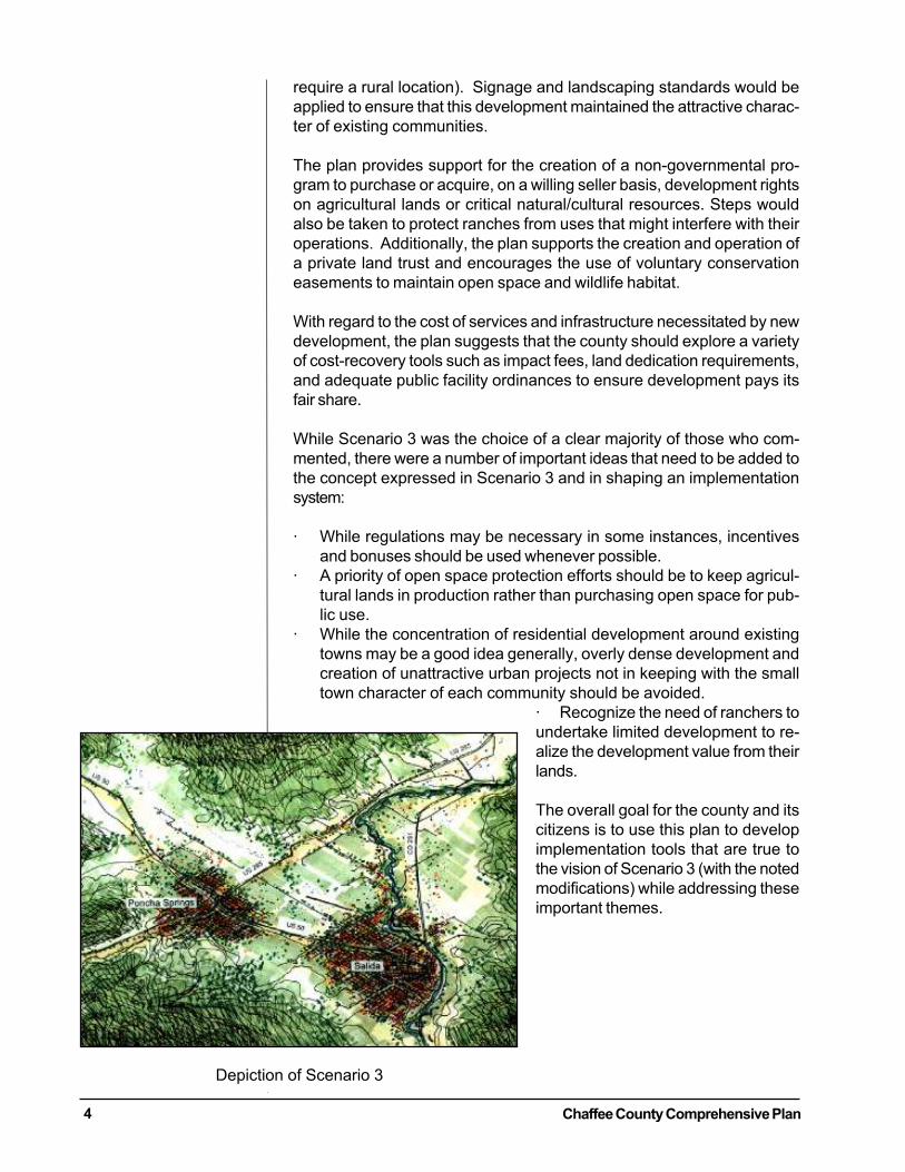
Depiction of Scenario 3
Chaffee County Comprehensive Plan 5
2. INTRODUCTION
Purpose of the Chaffee County Comprehensive Plan
The Chaffee County Comprehensive Plan is a response to issues that havearisen as a result of increased growth and development the County hasseen in the past few years. While the primary focus of the plan is land useand the impact growth will have on land use decisions, there are manydifferent areas (such as housing, and community facilities) that are alsoeffected. The plan is comprehensive in that it covers an entire geographicplanning area, and all the functions that make a community work includ-ing;
Land Use;Community Character;Open Space/Agricultural Land;Natural/Cultural Resources;Transportation;Affordable Housing;Community Facilities; andEconomic Development.
The plan is a guide for decision-makers, whetherthey are Chaffee County Commissioners, theCounty Manager, County Planning Staff, andofficials of the various County municipalities.It proposes goals, objectives, and implementa-tion steps that address the issues embeddedwithin each of these planning areas. Given theamount of public participation, the goals, ob-jectives, and action steps are all designed toachieve the desires of County residents. Whilereflecting social and economic values, it guidesthe physical development of the County byaddressing land use, open space, and densityissues. There are, however, certain broad is-sues that provide overarching themes for theentire Plan. These issues are described below.
Rapid Growth and Change
Chaffee County’s rapid growth has broughtabout much change in land use and commu-nity demographics. In a dramatic rebound from
the first half of the 1980s when the county actually lost population due tothe economic impact of the Climax mine closure near Leadville, it grewat an annual average rate of 3% during the first half of the 1990s. Incomparison, during the 1970s, the last big growth spurt for the county,annual growth rates were around 2.7%. Since 1995, the county growthrate has been over 5% annually, and the county’s population topped15,000. Between 1995 and 1997, the statewide growth rate was about
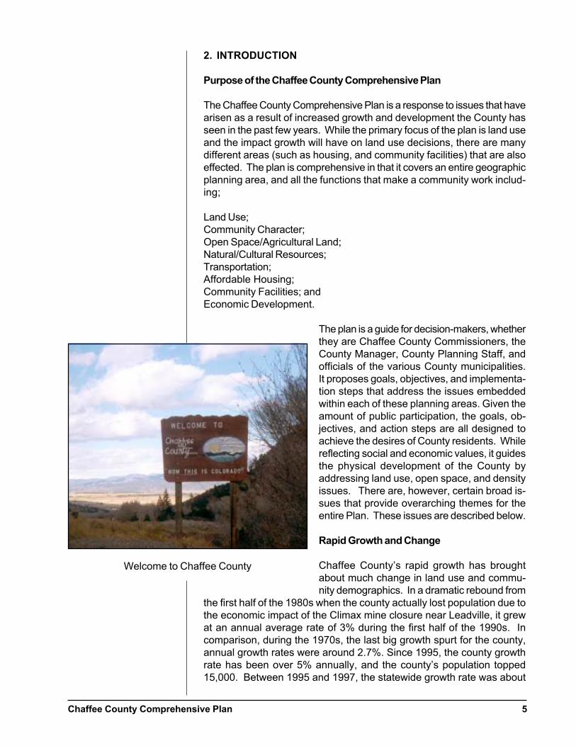
Welcome to Chaffee County
Chaffee County Comprehensive Plan6
2%, and the national growth rate around 1% annually. Property valueshave skyrocketed since 1990-doubling, tripling, and more in some in-stances-thus increasing the assets of those owning homes and land. Countysales tax revenues increased by 70% during the same period. Unemploy-ment fell from 6.7% in 1990 to only about 4% today.
Nature of the Growth
Scattered residential developments throughout the county are changingthe area’s rural and scenic character and in some cases causing conflictswith existing ranching operations. The bulk of new building activity hasbeen in the unincorporated portions of the county. The costs of provid-ing public services to these developments continue to rise and are plac-ing a financial strain on Chaffee County. Many of the citizens worryabout the potential negative impact of development on the county’s wild-life and natural resources.
While there was a slight cooling of development activity in the countyduring 1997, most signs point to continued growth. These signs include:
· The national and state economies remain strong;· The number of inquiries at the local chambers of commerce by po-
tential new residents remain high; and· The continued widening of Highway 285, the Denver area’s gateway
to Chaffee County, will shave more time off the drive from the state’slargest population concentration.
The lots to accommodate this growth exist. As of 1998, the County hadapproximately 2,493 already subdivided, recorded lots, many in ruralareas. At least in the short term, the lack of water for development inunincorporated areas has evaporated as a constraint development as theUpper Arkansas Water Conservancy District has made supplies availableon a broad basis in most areas of the county. The district has enoughwater to allow construction of up to about 1,700 dwelling units (if re-stricted to in-house use), the equivalent of about 4,400 people. Also thedistrict is continually seeking to purchase additional water rights, whichwould allow for additional development.
Per Capita Income
Not everyone has shared in the boom. Real per capita income in thecounty barely grew during the last decade and remains far below the stateaverage. Coupled with rising land and building costs, finding affordablehousing has become a real challenge for many residents. Not surpris-ingly, the number of workers who live elsewhere like in Saguache Countywhere housing is cheaper, and commute to jobs in Chaffee County con-tinues to grow. Real estate professionals recognize that most of the newresidential construction in the county over the past few years has been fornewcomers or non-residents building second homes.
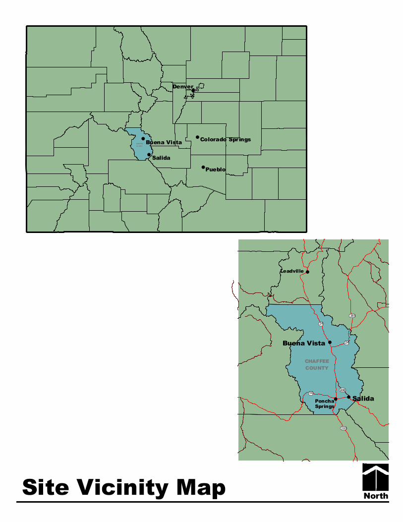
North
#
#
#
#
#
Colorado Springs
Pueblo
CHAFFEE
CO UNTY
Denver
Buena Vista
Salida
#
##
#
ø÷291
CHAFFEE
COUNTY
Leadville
PonchaSprings
Buena Vista
ôó50
ôó24
ø÷285
ø÷285
ôó24
Salida
Site Vicinity Map
Chaffee County Comprehensive Plan 7
Public Process
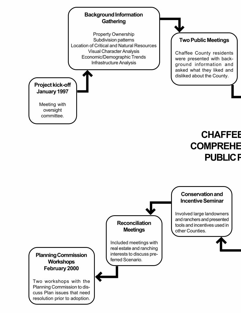
The process for creating the Chaffee County Comprehensive Plan wasguided by the participation of local residents, property owners, businesspeople, municipal and county officials, and appropriate state and federalagencies. All participated in varying degrees in gathering information,identifying issues, developing goals and objectives, and finally, deter-mining implementation strategies for a preferred land use plan. The plan-ning process also included an oversight committee appointed by the Boardof County Commissioners. The committee served as a source of informa-tion and as a sounding board for the planning effort.
A key initial step in putting the plan together was to gather backgroundinformation upon which to build the plan; property ownership and sub-division patterns, location of critical natural and cultural resources, a vi-sual character analysis that identified key open space parcels, a study ofeconomic and demographic trends, current zoning, and an analysis ofinfrastructure capacity of the county and towns (water, sewer, fire protec-tion, etc.). This information was presented at two county wide publicworkshops at which citizens were asked what they liked and did not likeabout their community and other questions related to growth and devel-opment.
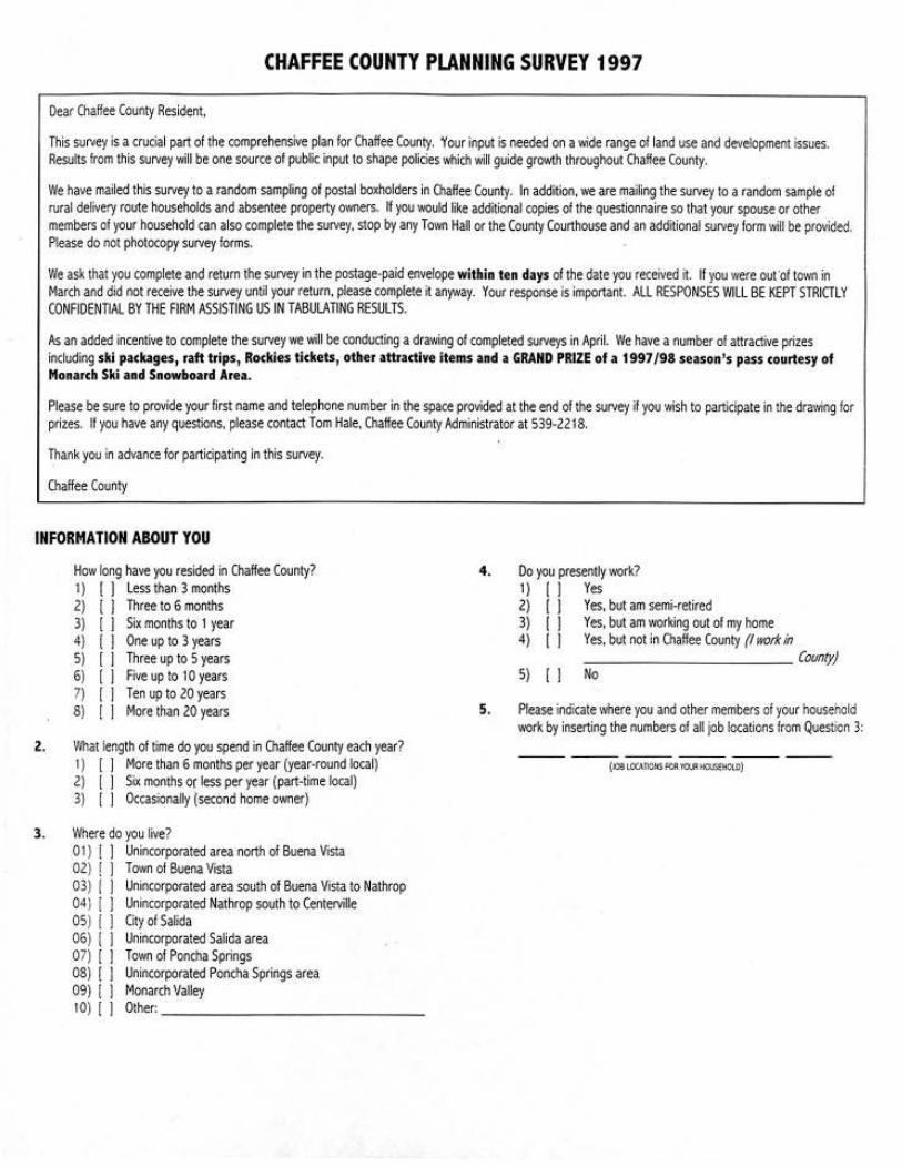
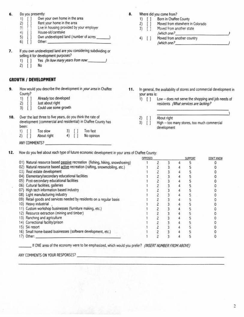
At the same time, the county commissioned an in-depth public opinionsurvey. Based on key issues identified at the public workshops, ques-tions were drafted by the consulting team and reviewed and revised bythe oversight committee and Board of County Commissioners. The sur-vey was then sent to over 3,700 residents and property owners in thecounty. The return rate was a very high 36% (1,332 respondents), whichensured a statistically valid response with a low margin of error. Respon-dents to the survey resembled the populace as a whole in terms of age,incomes, percent of home ownership, and other important indicators. (Asummary of survey methodology and results is provided in Appendix Aand the survey instrument is located in Appendix B.)
Based on these background studies, the public survey, and two well-attended community wide workshops, the consulting team developed inMay 1997 a list of “top ten” goals and objectives to be used as key prin-ciples to guide development of the plan. These goals and objectives (setforth on pages 2 and 3, in no order of priority) were revised, refined, andexpanded to 11 goals based on comments by the oversight committeeand board of county commissioners and then presented to the public atanother series of community workshops in the summer. Further changeswere made in response to public comment that set the stage for produc-tion of four alternative development scenarios. For a full description ofthe public process, please see the following graphic insert.
Land Use Scenarios
The four alternative development scenarios are visions of different waysin which Chaffee County could grow over the next twenty years, where
Chaffee County Comprehensive Plan8
growth might occur, how fast the county might grow, and what will newdevelopment look like. (One set of scenarios is depicted in general termson the following pages. See Appendix C for a full discussion.)
Each of the four scenarios differs in regarding the key attributes of growthsuch as location, environmental and fiscal impact, amount and rate, andquality. Written descriptions and sketches of each scenario were pub-lished in the local newspaper, exhibited in post offices throughout thecounty, and were the subject of four county wide workshops. Citizenswere asked to evaluate the pros and cons of each and to help craft apreferred scenario out of the four alternatives offered. Based on this inputand dozens of written comments, a preferred development scenarioemerged.
This preferred scenario was then presented at a major county wide publicworkshop in November 1997 attended by over 125 citizens. After adiscussion of key elements of the preferred scenario, participants brokeinto small working groups to discuss a range of implementation tools andtechniques that best fit Chaffee County. The final plan presented here isbased on recommendations from these working groups. The followinggraphic provides an overview of the public process.
CHAFFEE COUNTY
COMPREHENSIVE PLAN
PUBLIC PROCESS
Background Information
Gathering
Property Ownership
Subdivision patterns
Location of Critical and Natural Resources
Visual Character Analysis
Economic/Demographic Trends
Infrastructure Analysis
Two Public Meetings
Chaffee County residents
were presented with back-
ground information and
asked what they liked and
disliked about the County.
Project kick-off
January 1997
Meeting with
oversight
committee.
Conservation and
Incentive Seminar
Involved large landowners
and ranchers and presented
tools and incentives used in
other Counties.
Reconciliation
Meetings
Included meetings with
real estate and ranching
interests to discuss pre-
ferred Scenario.Planning Commission
Workshops
February 2000
Two workshops with the
Planning Commission to dis-
cuss Plan issues that need
resolution prior to adoption.

CHAFFEE COUNTY
COMPREHENSIVE PLAN
PUBLIC PROCESS
Community Surveys
Surveys were sent to
3,700 County residents
resulted in 36% return
rate. See Appendix A for
results.
Interviews with
CommunityLeaders
One on one interviews
with community leaders,
environmentalists, govern-
ment officials, landown-
ers, developers on plan-
ning topics.
Six County-wide
Workshops
Residents discussed
goals, objectives, and al-
ternative development
scenarios.
Development of Goals and
Objectives – May 1997
Based on the information gath-
ered from the background data,
public meetings, and interviews,
11 goals were developed.
Planning Commission
Workshops
Workshop tailored to local
planning commissioners to dis-
cuss enabling authority, plan-
ning tools, and legal issues.Morning Workshop
Attended by 125 citizens
to discuss and evaluate
tools available to imple-
ment the plan.
Newspaper Inserts &
Public Displays
Inserts and displays in public
places described alternative
development scenarios.
One on One Meetings
with Landowners
Estate planning techniques
were discussed to assist fami-
lies in protecting property from
break up due to estate taxes.
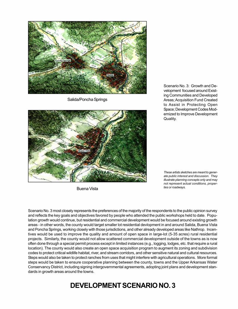
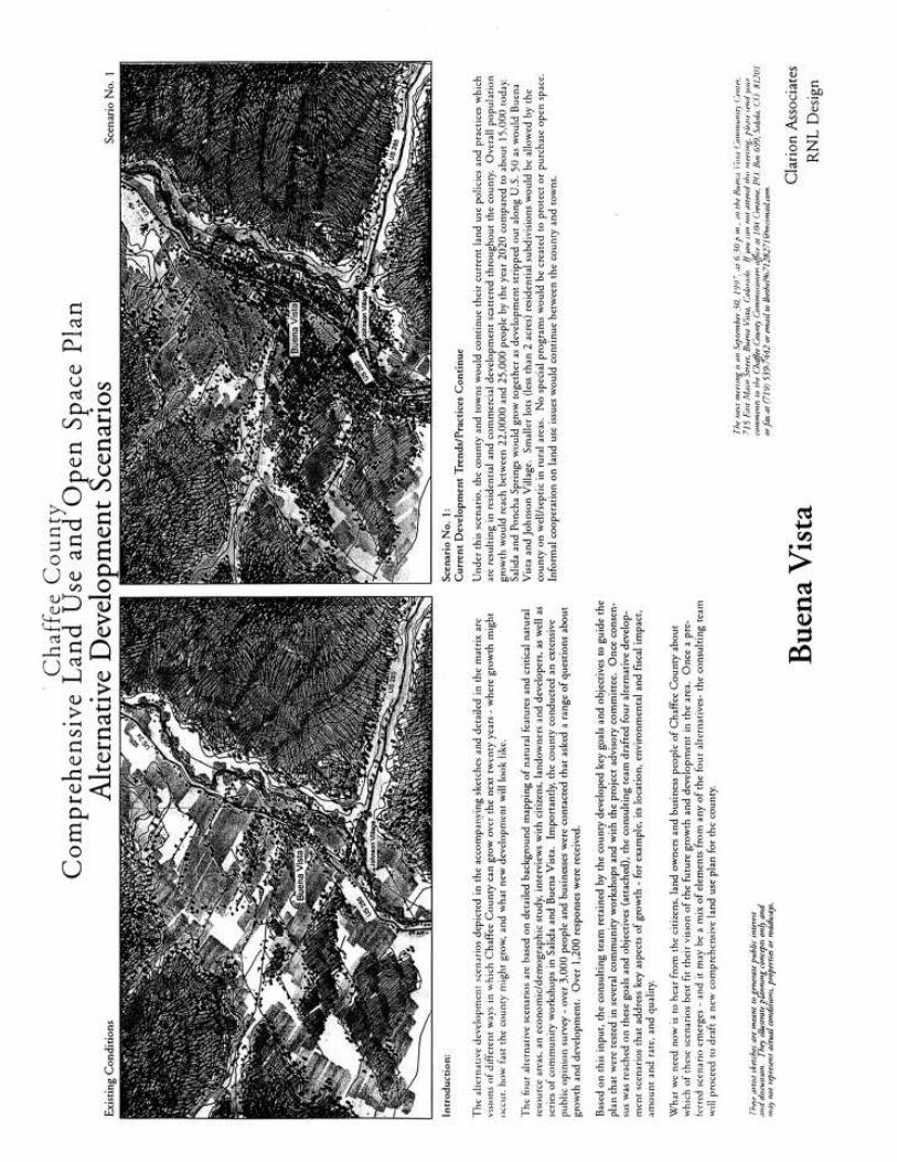
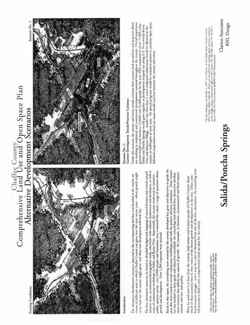
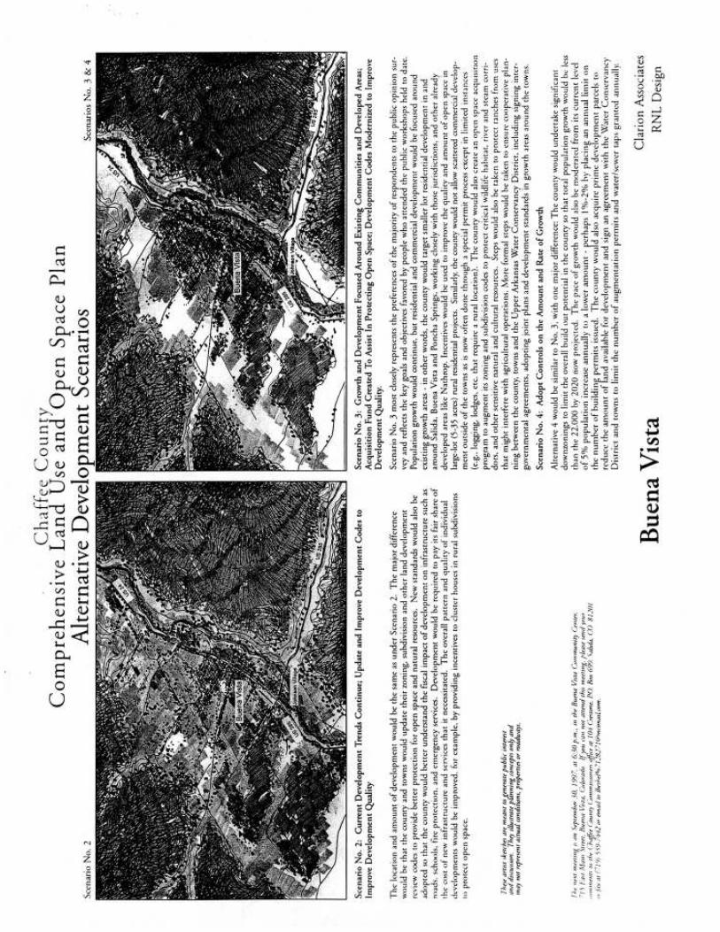
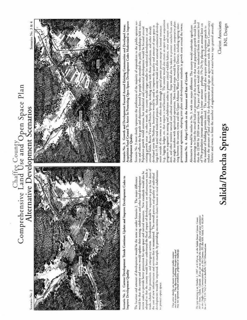
Scenario No. 3 most closely represents the preferences of the majority of the respondents to the public opinion survey
and reflects the key goals and objectives favored by people who attended the public workshops held to date. Popu-
lation growth would continue, but residential and commercial development would be focused around existing growth
areas - in other words, the county would target smaller lot residential devlopment in and around Salida, Buena Vista
and Poncha Springs, working closely with those jurisdictions, and other already developed areas like Nathrop. Incen-
tives would be used to improve the quality and amount of open space in large-lot (5-35 acres) rural residential
projects. Similarly, the county would not allow scattered commercial development outside of the towns as is now
often done through a special permit process except in limited instances (e.g., logging, lodges, etc. that require a rural
location). The county would also create an open space acquisition program to augment its zoning and subdivision
codes to protect critical wildlife habitat, river, and stream corridors, and other sensitive natural and cultural resources.
Steps would also be taken to protect ranches from uses that might interfere with agricultural operations. More formal
steps would be taken to ensure cooperative planning between the county, towns and the Upper Arkansas Water
Conservancy District, including signing intergovernmental agreements, adopting joint plans and development stan-
dards in growth areas around the towns.
Scenario No. 3: Growth and De-
velopment focused around Exist-
ing Communities and Developed
Areas; Acquisition Fund Created
to Assist in Protecting Open
Space; Development Codes Mod-
ernized to Improve Development
Quality.
These artists sketches are meant to gener-
ate public interest and discussion. They
illustrate planning concepts only and may
not represent actual conditions, proper-
ties or roadways.
Salida/Poncha Springs
Buena Vista
DEVELOPMENT SCENARIO NO. 3
Chaffee County Comprehensive Plan 9
3. EXISTING CONDITIONS: A SNAPSHOT OF CHAFFEE COUNTY
To set the stage for comprehensive plan goals, objectives, and implemen-tation policies, the consulting team spent several months early in the projectdocumenting the existing physical, social, and economic context of ChaffeeCounty. With the assistance of local, state, and federal agencies andlocal citizens, the team gathered information about:
· Natural and cultural resources (wildlife habitat, watersheds, historicsites, trails, etc.);
· Infrastructure systems (water, sewer, roads, etc.) and existing govern-ment services both in the county and towns;
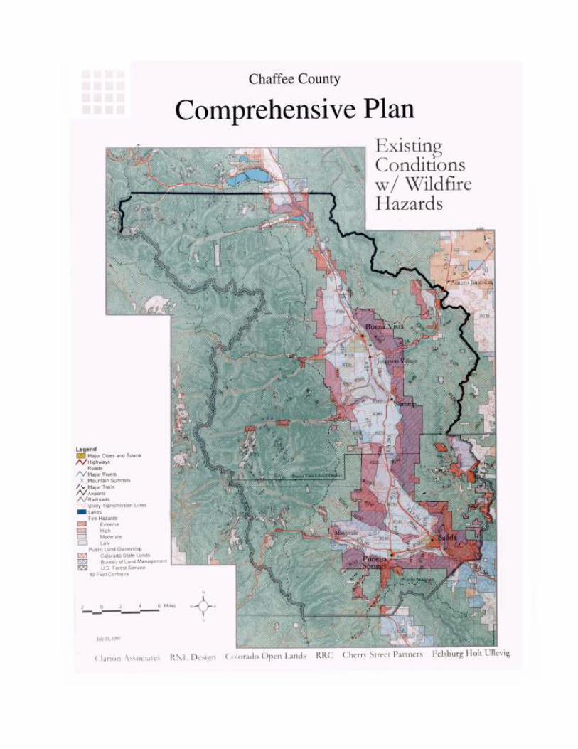
· Community and visual character;· Wildfire hazard areas;· Steep slopes and geologic hazard areas;· Economic, demographic, and housing trends; and· Land use patterns and current zoning.
Based on this information, the team produced a number of reports suchas a detailed economic/demographic study, an infrastructure assessment,and a variety of planning maps. These documents and maps were re-viewed and revised with the assistance of the oversight committee andagency officials. This information, summarized below, helped to framekey issues and establish a solid base upon which to make realistic choicesthroughout the planning process.
Location and Prominent Physical Characteristics
Chaffee County is one of the most stunningly beautiful areas in the UnitedStates. Surrounded by high mountain peaks, it is graced with alpine riversand streams, broad expanses of ranch land and meadows, and landscapes
that vary from rolling pinon and juniper foreststo rugged wilderness.
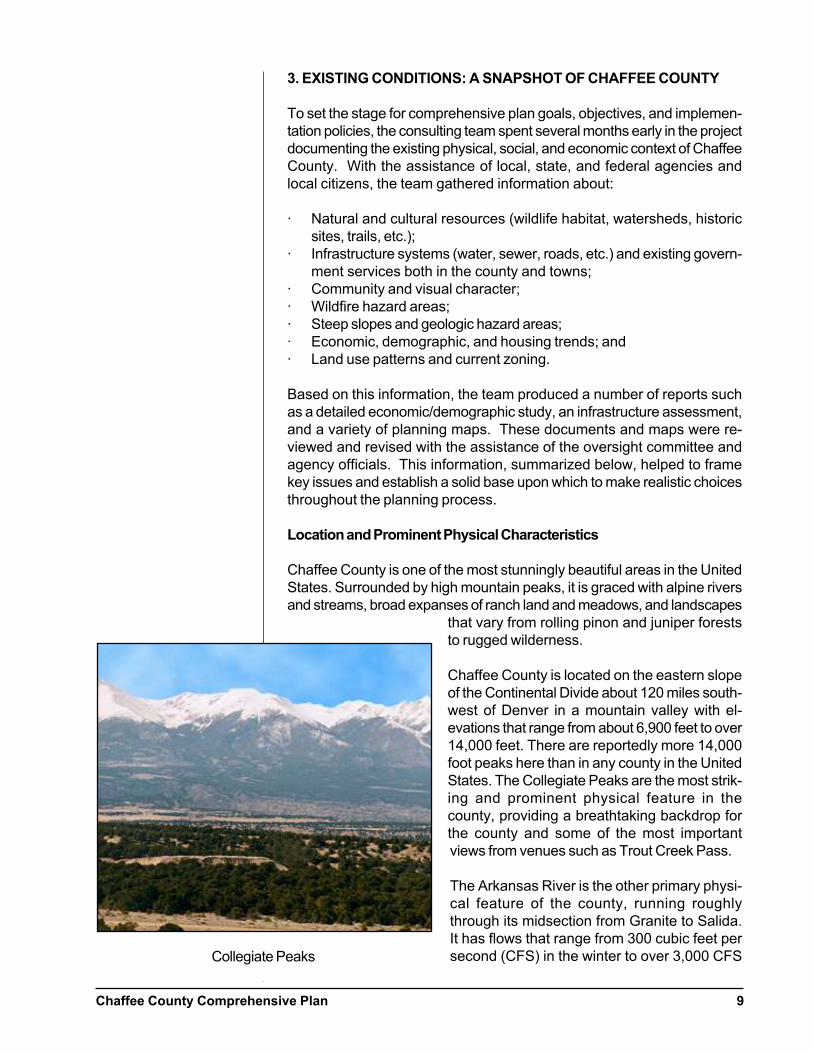
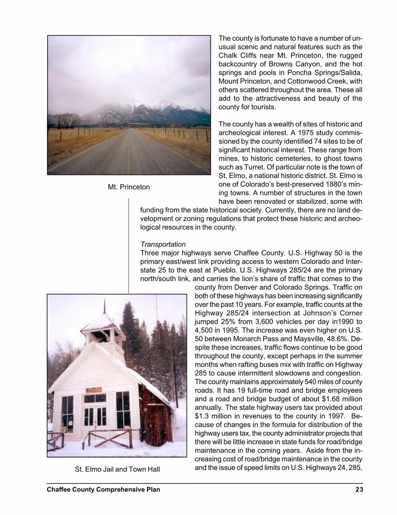
Chaffee County is located on the eastern slopeof the Continental Divide about 120 miles south-west of Denver in a mountain valley with el-evations that range from about 6,900 feet to over14,000 feet. There are reportedly more 14,000foot peaks here than in any county in the UnitedStates. The Collegiate Peaks are the most strik-ing and prominent physical feature in thecounty, providing a breathtaking backdrop forthe county and some of the most importantviews from venues such as Trout Creek Pass.
The Arkansas River is the other primary physi-cal feature of the county, running roughlythrough its midsection from Granite to Salida.It has flows that range from 300 cubic feet persecond (CFS) in the winter to over 3,000 CFSCollegiate Peaks
Chaffee County Comprehensive Plan10
during spring runoff. U.S. Highways 285, 24, and 50, the three majortransportation corridors in the county, parallel the Arkansas River as itruns north to south and then west to east in the county. The views fromthese three highways towards the surrounding mountains and across theArkansas River and its tributaries do much to establish the rural, sceniccharacter of the county. Most of the county has slopes of over 10% andover one-third has slopes in excess of 25%. The Valley soils are typicallythin, rocky, and somewhat alkaline. However, soils in a broad band run-ning along the west side of the Arkansas River are generally suitable fordevelopment and agricultural uses.
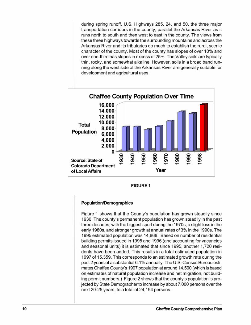
Population/Demographics
Figure 1 shows that the County’s population has grown steadily since1930. The county’s permanent population has grown steadily in the pastthree decades, with the biggest spurt during the 1970s, a slight loss in theearly 1980s, and stronger growth at annual rates of 3% in the 1990s. The1995 estimated population was 14,868. Based on number of residentialbuilding permits issued in 1995 and 1996 (and accounting for vacanciesand seasonal units) it is estimated that since 1995, another 1,720 resi-dents have been added. This results in a total estimated population in1997 of 15,359. This corresponds to an estimated growth rate during thepast 2 years of a substantial 6.1% annually. The U.S. Census Bureau esti-mates Chaffee County’s 1997 population at around 14,500 (which is basedon estimates of natural population increase and net migration, not build-ing permit numbers.) Figure 2 shows that the county’s population is pro-jected by State Demographer to increase by about 7,000 persons over thenext 20-25 years, to a total of 24,194 persons.
FIGURE 1
02,0004,0006,0008,000
10,00012,00014,00016,000
Total
Population
1930
1940
1950
1960
1970
1980
1990
1998
Year
Chaffee County Population Over Time
Source: State of
Colorado Department
of Local Affairs

Chaffee County Comprehensive Plan 11
Most of the County’s new residents come from within Colorado, but alarge proportion of recent home buyers are from Kansas, the mid-West, aswell as California and Texas. Most are higher-income households thanthe existing average permanent resident households.
Seasonal Population
In 1990, the U.S. Census estimated that 16% of housing units in thecounty were for seasonal or occasional use only, which equals 1,059units. At an average of 2.4 persons per unit in 1990, that represented anestimated seasonal population of about 2,500 persons. Realtors reportthat more recent home sales have been for permanent rather than sea-sonal occupancy.
Personal incomes are significantly below average for the state. The mostrecent data show per capita incomes in 1994 only about two-thirds ofstate average: $11,880 in the county vs. $17,420 for Colorado, and thatthey had barely increased in real terms since 1985. (See Demographicreport for updates.)
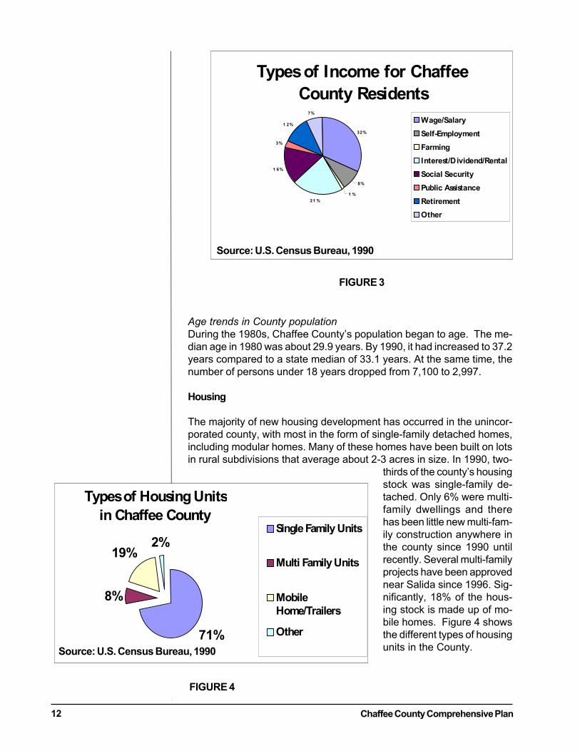
Components of Personal Income in Chaffee County
In 1993, almost one-half of all personal income was derived from “un-earned income” or income from all sources other than participation inlabor force (e.g., pensions, interest, dividends, social security & othertransfer payments). In the U.S., unearned income percentage is only about33%. This suggests Chaffee County has enjoyed a large in-migration ofretirees and older persons who typically receive the lion’s share of suchincome. There are some substantial benefits from this trend. These fundsare a stable source of income and economic support for the local commu-nity; and many small-business start-ups are typically financed at least inpart from personal wealth of founders and their relatives. In addition,much of that unearned income is transferred to local banks and trusts,where it contributes to a base of financial support for new business in-vestment in the community. Figure 3 shows the distribution of types ofincome for Chaffee County.
Chaffee County Population Projection,
2000-2025
24,19122,72621,21719,72118,25016,745
0
5,000
10,000
15,000
20,000
25,000
30,000
2000 2005 2010 2015 2020 2025
Year
To
tal
Po
pu
lati
on
FIGURE 2
Source: State of Colorado
Department of Local Affairs
Chaffee County Comprehensive Plan12
Age trends in County population
During the 1980s, Chaffee County’s population began to age. The me-dian age in 1980 was about 29.9 years. By 1990, it had increased to 37.2years compared to a state median of 33.1 years. At the same time, thenumber of persons under 18 years dropped from 7,100 to 2,997.
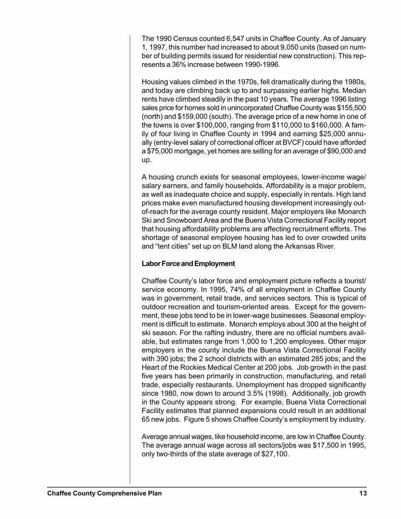
Housing
The majority of new housing development has occurred in the unincor-porated county, with most in the form of single-family detached homes,including modular homes. Many of these homes have been built on lotsin rural subdivisions that average about 2-3 acres in size. In 1990, two-
thirds of the county’s housingstock was single-family de-tached. Only 6% were multi-family dwellings and therehas been little new multi-fam-ily construction anywhere inthe county since 1990 untilrecently. Several multi-familyprojects have been approvednear Salida since 1996. Sig-nificantly, 18% of the hous-ing stock is made up of mo-bile homes. Figure 4 showsthe different types of housingunits in the County.
Types of Housing Units
in Chaffee County
71%
8%
19%2%
Single Family Units
Multi Family Units
Mobile
Home/Trailers
Other
Source: U.S. Census Bureau, 1990
FIGURE 4
Types of Income for Chaffee
County Residents
32%
8%
1 %
21 %
1 6%
3%
1 2%
7%
Wage/Salary
Self-Employment
Farming
Interest/Dividend/Rental
Social Security
Public Assistance
Retirement
Other
Source: U.S. Census Bureau, 1990
FIGURE 3
Chaffee County Comprehensive Plan 13
The 1990 Census counted 6,547 units in Chaffee County. As of January1, 1997, this number had increased to about 9,050 units (based on num-ber of building permits issued for residential new construction). This rep-resents a 36% increase between 1990-1996.
Housing values climbed in the 1970s, fell dramatically during the 1980s,and today are climbing back up to and surpassing earlier highs. Medianrents have climbed steadily in the past 10 years. The average 1996 listingsales price for homes sold in unincorporated Chaffee County was $155,500(north) and $159,000 (south). The average price of a new home in one ofthe towns is over $100,000, ranging from $110,000 to $160,000. A fam-ily of four living in Chaffee County in 1994 and earning $25,000 annu-ally (entry-level salary of correctional officer at BVCF) could have affordeda $75,000 mortgage, yet homes are selling for an average of $90,000 andup.
A housing crunch exists for seasonal employees, lower-income wage/salary earners, and family households. Affordability is a major problem,as well as inadequate choice and supply, especially in rentals. High landprices make even manufactured housing development increasingly out-of-reach for the average county resident. Major employers like MonarchSki and Snowboard Area and the Buena Vista Correctional Facility reportthat housing affordability problems are affecting recruitment efforts. Theshortage of seasonal employee housing has led to over crowded unitsand “tent cities” set up on BLM land along the Arkansas River.
Labor Force and Employment
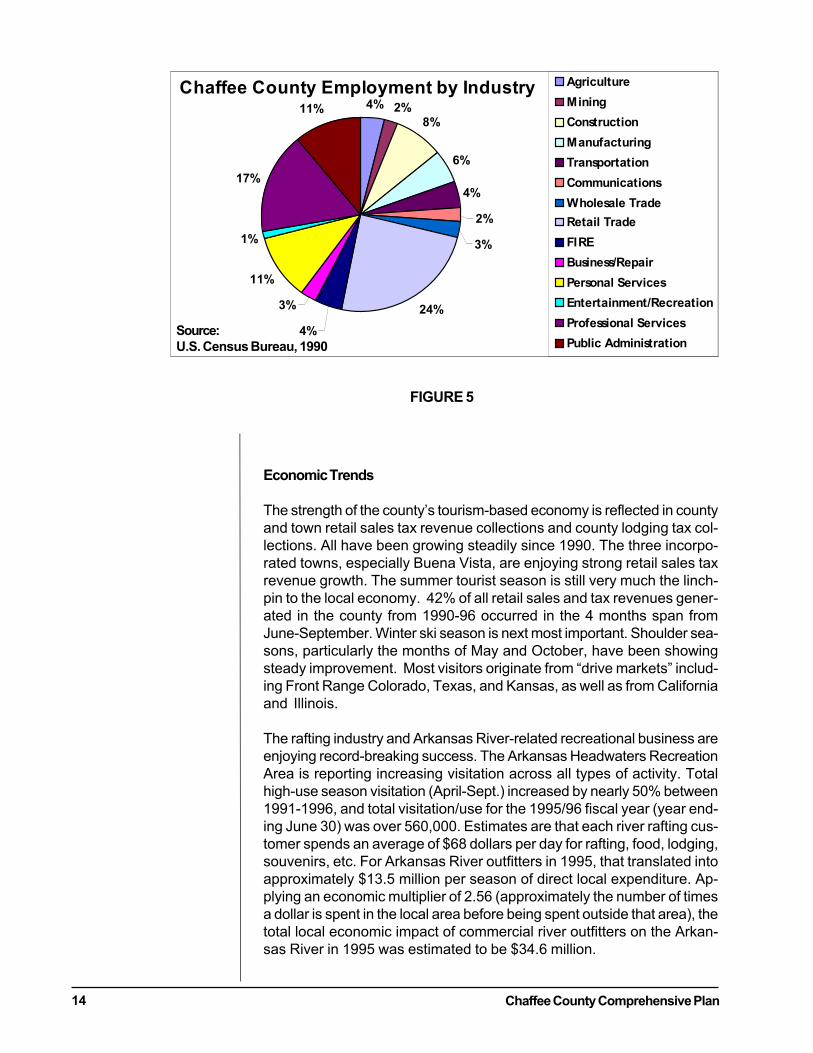
Chaffee County’s labor force and employment picture reflects a tourist/service economy. In 1995, 74% of all employment in Chaffee Countywas in government, retail trade, and services sectors. This is typical ofoutdoor recreation and tourism-oriented areas. Except for the govern-ment, these jobs tend to be in lower-wage businesses. Seasonal employ-ment is difficult to estimate. Monarch employs about 300 at the height ofski season. For the rafting industry, there are no official numbers avail-able, but estimates range from 1,000 to 1,200 employees. Other majoremployers in the county include the Buena Vista Correctional Facilitywith 390 jobs; the 2 school districts with an estimated 285 jobs; and theHeart of the Rockies Medical Center at 200 jobs. Job growth in the pastfive years has been primarily in construction, manufacturing, and retailtrade, especially restaurants. Unemployment has dropped significantlysince 1980, now down to around 3.5% (1998). Additionally, job growthin the County appears strong. For example, Buena Vista CorrectionalFacility estimates that planned expansions could result in an additional65 new jobs. Figure 5 shows Chaffee County’s employment by industry.
Average annual wages, like household income, are low in Chaffee County.The average annual wage across all sectors/jobs was $17,500 in 1995,only two-thirds of the state average of $27,100.
Chaffee County Comprehensive Plan14
Economic Trends
The strength of the county’s tourism-based economy is reflected in countyand town retail sales tax revenue collections and county lodging tax col-lections. All have been growing steadily since 1990. The three incorpo-rated towns, especially Buena Vista, are enjoying strong retail sales taxrevenue growth. The summer tourist season is still very much the linch-pin to the local economy. 42% of all retail sales and tax revenues gener-ated in the county from 1990-96 occurred in the 4 months span fromJune-September. Winter ski season is next most important. Shoulder sea-sons, particularly the months of May and October, have been showingsteady improvement. Most visitors originate from “drive markets” includ-ing Front Range Colorado, Texas, and Kansas, as well as from Californiaand Illinois.
The rafting industry and Arkansas River-related recreational business areenjoying record-breaking success. The Arkansas Headwaters RecreationArea is reporting increasing visitation across all types of activity. Totalhigh-use season visitation (April-Sept.) increased by nearly 50% between1991-1996, and total visitation/use for the 1995/96 fiscal year (year end-ing June 30) was over 560,000. Estimates are that each river rafting cus-tomer spends an average of $68 dollars per day for rafting, food, lodging,souvenirs, etc. For Arkansas River outfitters in 1995, that translated intoapproximately $13.5 million per season of direct local expenditure. Ap-plying an economic multiplier of 2.56 (approximately the number of timesa dollar is spent in the local area before being spent outside that area), thetotal local economic impact of commercial river outfitters on the Arkan-sas River in 1995 was estimated to be $34.6 million.
Chaffee County Employment by Industry4% 2%
8%
6%
4%
2%
3%
24%
4%
3%
11%
1%
17%
11%
Agriculture
Mining
Construction
Manufacturing
Transportation
Communications
Wholesale Trade
Retail Trade
FIRE
Business/Repair
Personal Services
Entertainment/Recreation
Professional Services
Public AdministrationSource:
U.S. Census Bureau, 1990
FIGURE 5
Chaffee County Comprehensive Plan 15
Monarch Ski and Snowboard Area visitation has held steady the past sev-eral years at an average level of 146,000 skiers. Monarch recently changedhands, and while the new owners have expressed interest in new capitalinvestments, particularly new base development, at this time things arestill too uncertain to project future events with any certainty. Recent re-ports indicate that the ski area may be up for sale again.
Ranchers own a significant amount of the private land in the county andthey have a modest impact on the local economy in terms of jobs andincome. As the total acres of land in farms/ranches has decreased overthe past ten years in the county, the value of agricultural sales (mainlycattle and hay crops) has also dropped. According to federal figures, thetotal acres of farm land decreased by 20% or 21,100 acres in the fiveyears between 1987 and 1992. The value of agricultural sales dropped17% during this period. In 1992, agribusiness, which includes actualproduction, agricultural inputs, and processing and marketing, accountedfor only 1.1% of Chaffee County’s total labor and proprietor income (com-pared to 18% in Saguache, 5.6 % in Alamosa, and 2% in Gunnison Coun-ties). The 1990 Census reported that the average farm self-employmentincome for 104 households that reported such income was $4,490 com-pared to the average household earnings in the county from salaries andwages of $23,985.
Climate
Chaffee County is known as the “banana belt” to most Coloradans be-cause of its relatively mild climate, despite its mountain valley location.Certainly when compared to the San Luis Valley to the south and GunnisonCounty to the west, the weather is positively balmy. Typically, tempera-tures in Salida run only 5-10 degrees cooler than Denver throughout theyear, despite an altitude difference of over 2,000 feet. The annual grow-ing season in Salida is 112 days and in Buena Vista, which typically runsa few degrees cooler, about 95 days. The average high temperature inSalida is 84 degrees in July and 33 degrees in January; in Buena Vista it is70 degrees and 31 degrees respectively. The county only receives about10-11 inches of precipitation annually at lower elevations, much of it inthe form of snow (around 4 feet annually in Salida and Buena Vista). Athigher elevations, such as Monarch Ski and Snowboard Area, the annualprecipitation is much higher due to heavy snowfalls. Humidity in thecounty stays low much of the year, and when coupled with the valley’sample sunshine, makes for an attractive place to live, work, and play forresidents and visitors alike.
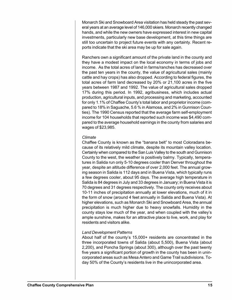
Land Development Patterns
About half of the county’s 15,000+ residents are concentrated in thethree incorporated towns of Salida (about 5,500), Buena Vista (about2,200), and Poncha Springs (about 300), although over the past twentyfive years a significant portion of growth in the county has been in unin-corporated areas such as Mesa Antero and Game Trail subdivisions. To-day 50% of the County’s residents live in the unincorporated area.
Chaffee County Comprehensive Plan16
The City of Salida is a statutory city with a mayor/council/administratorform of government; it is the Chaffee County Seat. It is the county’s largestmunicipality and has seen the most growth of the three incorporated ar-eas since 1970, gaining about 1,200 people. Salida provides water andsewer services for its residents, surrounding unincorporated areas, andsewer treatment for Poncha Springs. The city is a major base for tourists,providing lodging and attractions such as the popular Salida Hot SpringsPool and an attractive downtown historic area. A large portion of thecounty’s retail and commercial base is located in Salida along U.S. 50,including a new Wal-Mart store and many other businesses. The town’seconomy has been growing steadily for the past several years, as wit-nessed by a significant increase in sales tax revenues since 1990 from
$537,00 to $829,000 in 1996. The city hasbeen working on a comprehensive plan (includ-ing a 3-mile plan) for the last several years, buthas not as yet completed that process.
The Town of Buena Vista, located in the north-ern reaches of the county, is a statutory townwith a mayor/council/administrator form of gov-ernment. Buena Vista has its own municipalwater system that serves the town and surround-ing developments, including the CorrectionalFacility. Sewage treatment service, is undergo-ing upgrading and expansion in the next fewyears, and is provided by the Buena Vista Sani-tation District. Like Salida, Buena Vista has wit-nessed steady growth in sales tax revenues since1990, nearly doubling from $330,000 to$636,000 in 1996. Buena Vista recently up-dated its comprehensive plan and subdivisionregulations, but has no 3-mile plan.
The Town of Poncha Springs is also a statutory town, with a mayor/coun-cil/manager form of government. Retail sales taxes generated by the tour-ist-oriented businesses clustered at the busy intersection of U.S. High-ways 285 and 50 are the mainstay of the town’s economy, although Ponchadoes have a substantial industrial park along County Road 120 near thecounty fairgrounds. The town provides its own water and receives sewerservice from Salida. The town has recently updated its comprehensiveplan.
The county has several significant unincorporated growth areas includingGranite and the Game Trail-area subdivisions north of Buena Vista, MesaAntero, and Nathrop in the county’s midsection, and Maysville andGarfield to the west of Poncha Springs. Scattered low-density rural subdi-visions have been approved throughout the county, many of which havesubdivided, but unbuilt lots. This equates to a potential of approximately4,700 units, which, if built out would be more than sufficient to meetprojected population growth in the county for the next 20 years.
Entrance to Buena Vista
Chaffee County Comprehensive Plan 17
Zoning
The county has traditional zoning that divides the jurisdiction into sevenbasic zones. The county has what is known as “pyramidal zoning.” Pyra-midal zoning allows all less intense uses such as residential in commer-cial zones and residential and commercial in industrial areas. The zoningmap following this section illustrates the zoning descriptions below.
R-1 Residential: This zone, located mainly around Salida and Buena Vista,is intended for a higher-density residential development where munici-pal services are readily available. Minimum lot size is 1/2 acre when thedevelopment is served by both public sewer and an approved on-sitewell.
RR Rural Residential: This zone, designated primarily west of Buena Vistaand west and north of Salida, is intended for single family residences andsome agricultural uses in a “country living atmosphere.” A wide variety ofcommercial uses (hospitals, day care centers, clinics, etc.) are allowed byspecial use permits. The minimum lot size is 2 acres, but can go as low as1/2 acre if the site is served by public sewer and an approved on-site well.
RS Rural Suburban Zone: This zone is intended to be an intermediatetype of district with uses compatible with Rural Residential, Rural, andRecreational zones. It is found all along the western edge of the countybordering public lands and north and west of Poncha Springs along High-ways 50 and 285. The purpose is to “provide areas suitable for suburbanliving on which animals and crops can be raised.” The minimum lot sizewas originally 10 acres, but the zoning resolution now allows 1 unit/2acres by right with lots as small as 1/2 acre if served by public sewer andan approved on-site well.
R Rural Zone: This zone is intended for all agricultural, farming, ranch-ing, other uses that require large acreages and separation from business,industrial, and urban residential uses. The purpose of the zone is to pre-serve and protect the best agricultural areas and maintain a desirable “ru-ral and scenic atmosphere.” This zone also allows a wide variety of com-mercial uses and multi-family dwellings by special use permit. Moreover,the minimum lot size is only 2 acres for rural residential and can go aslow as 1/2 acre when served by public sewer and an approved on-sitewell.
RC Recreational Zone: This zone consists of all private land within bound-aries of the public domain. Many uses that are “compatible” with publiclands are allowed, including residential, hospitals, recreational facilities,dude ranches, business and professional offices, industry, etc. The mini-mum lot size for residential is 2 acres, although again this may be re-duced to 1/2 acre if serviced by public sewer.
C Commercial: This zone, mapped along major arterials and highwaysnear incorporated towns, is intended to permit the development of com-mercial uses and services to serve the county and tourist related needs. A
Chaffee County Comprehensive Plan18
wide variety of commercial uses are allowed as well as residential andother non-commercial uses. Minimum lot size is the typical 1/2 acre if onpublic water and sewer and 2 acres otherwise.
I Industrial: This zone provides for a variety of industrial uses and anyother use permitted in other zones. Minimum lot size is the same as inother districts. Industrial areas are mapped around the two municipal air-ports in the county and several other locations near Buena Vista and Salida.
Interestingly, the county land development codes do not permit use oftechniques such as cluster development that can help protect open spacewithout affecting a property’s overall allowable density. The resolutionalso provides for few development incentives.
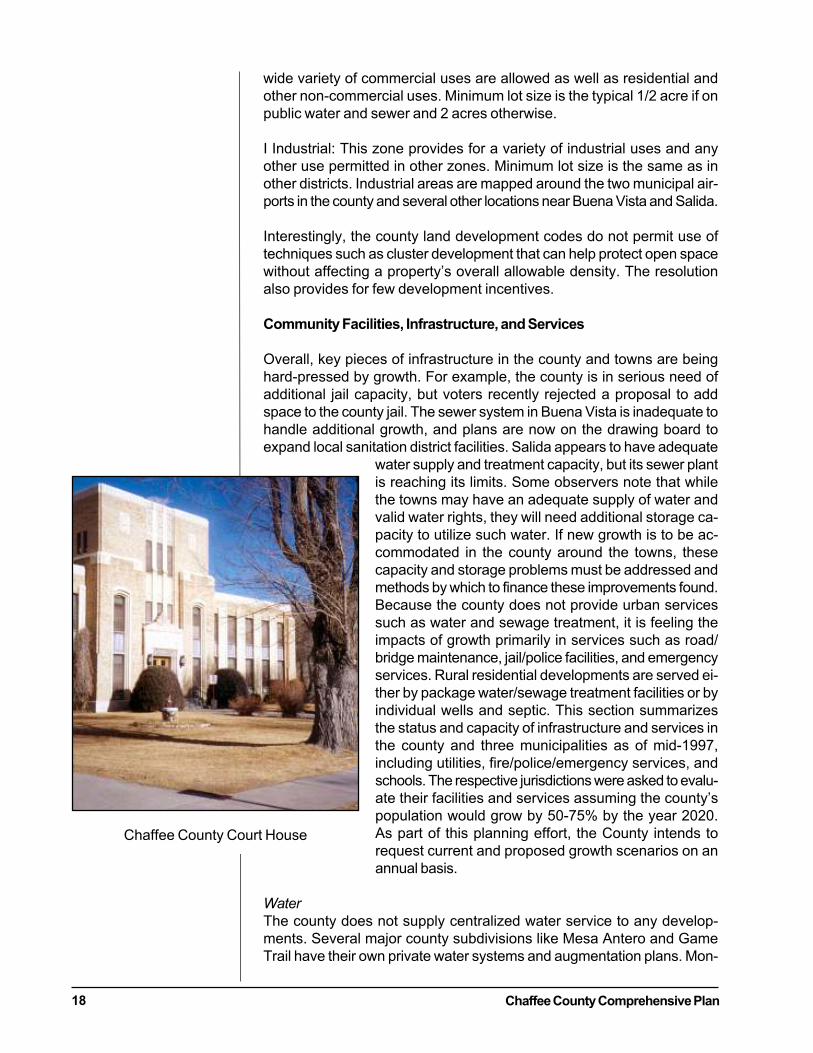
Community Facilities, Infrastructure, and Services
Overall, key pieces of infrastructure in the county and towns are beinghard-pressed by growth. For example, the county is in serious need ofadditional jail capacity, but voters recently rejected a proposal to addspace to the county jail. The sewer system in Buena Vista is inadequate tohandle additional growth, and plans are now on the drawing board toexpand local sanitation district facilities. Salida appears to have adequate
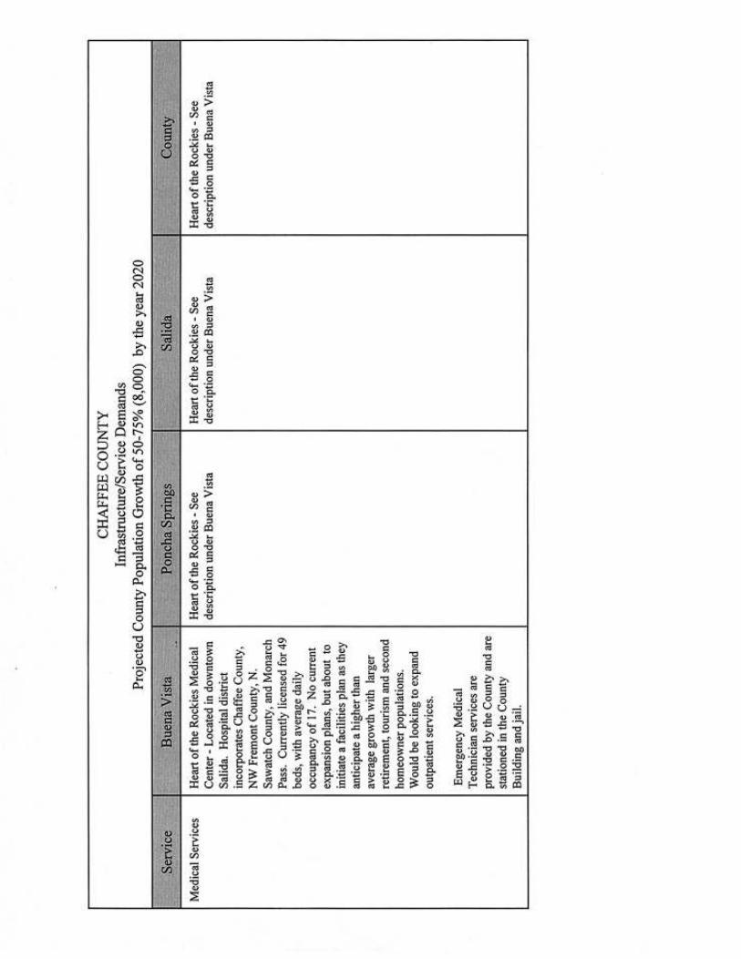
water supply and treatment capacity, but its sewer plantis reaching its limits. Some observers note that whilethe towns may have an adequate supply of water andvalid water rights, they will need additional storage ca-pacity to utilize such water. If new growth is to be ac-commodated in the county around the towns, thesecapacity and storage problems must be addressed andmethods by which to finance these improvements found.Because the county does not provide urban servicessuch as water and sewage treatment, it is feeling theimpacts of growth primarily in services such as road/bridge maintenance, jail/police facilities, and emergencyservices. Rural residential developments are served ei-ther by package water/sewage treatment facilities or byindividual wells and septic. This section summarizesthe status and capacity of infrastructure and services inthe county and three municipalities as of mid-1997,including utilities, fire/police/emergency services, andschools. The respective jurisdictions were asked to evalu-ate their facilities and services assuming the county’spopulation would grow by 50-75% by the year 2020.As part of this planning effort, the County intends torequest current and proposed growth scenarios on anannual basis.
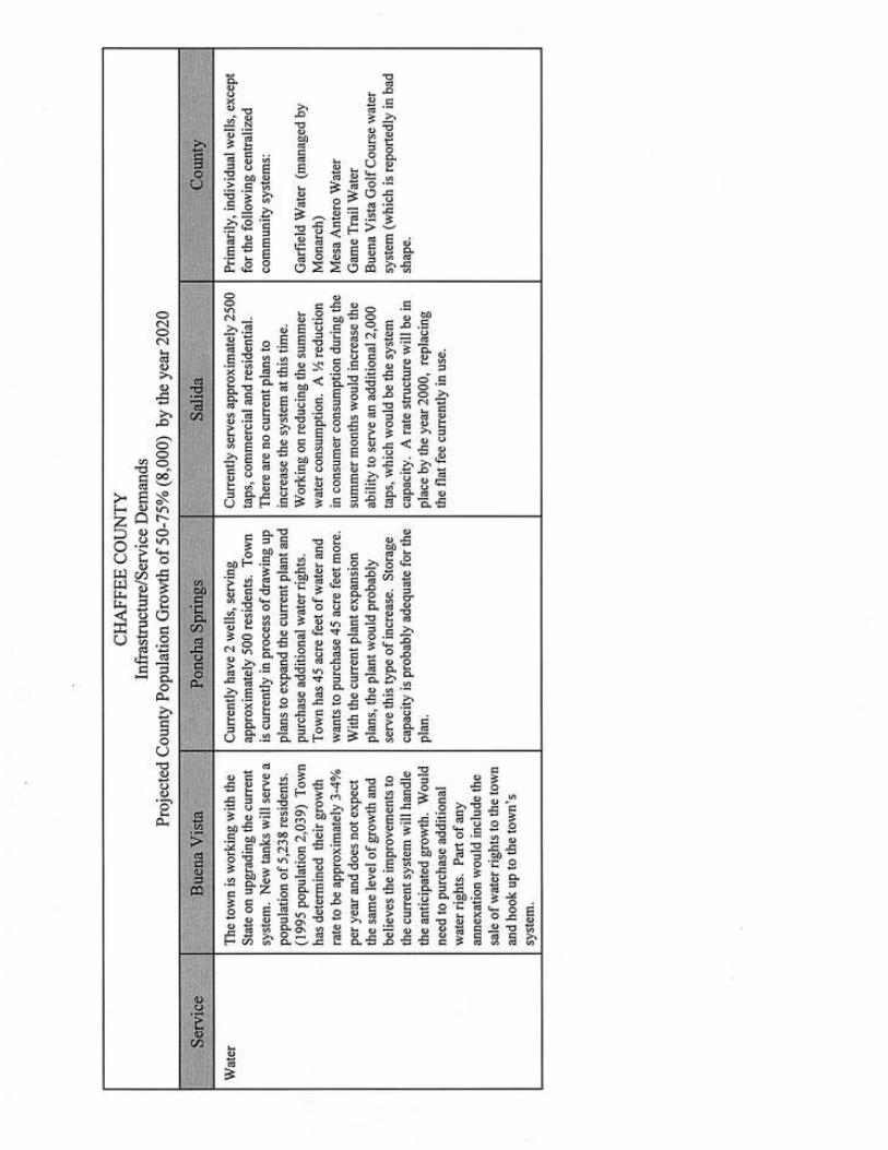
Water
The county does not supply centralized water service to any develop-ments. Several major county subdivisions like Mesa Antero and GameTrail have their own private water systems and augmentation plans. Mon-
Chaffee County Court House
Chaffee County Comprehensive Plan 19
arch Ski and Snowboard Area also has its own system for the Garfieldtown site; this system has been made possible through water augmenta-tion by the Upper Arkansas Water Conservancy District. The City ofSalida reports that it has adequate water supplies and treatment capacityat present, but is working to reduce summer consumption to increase thesystem capacity. However, recently there have been reports that the citymany not have sufficient water supply/water rights or the storage capacityto use such water. Poncha Springs reports it currently has two wells serv-ing about 500 residents, and the water supply to serve 500 more. It iscurrently in the process of drawing up plans to expand its existing plantand purchase additional water rights. Again, some observers maintainthat Poncha, which like Salida relies on the Upper Arkansas Water Con-servancy District reservoirs for storage capacity, does not have adequatefuture storage capacity to accommodate additional growth that is pro-jected. The Town of Buena Vista has upgraded its water storage capacitywith tanks that will enable it to serve over 5,000 residents (vs. a currentpopulation of just over 2,000). Additional water rights will need to besecured to serve projected population increases as well as storage capac-ity. Recent water rate increases have apparently led to greater water con-servation efforts by citizens, thus stretching the town’s existing water sup-ply. The Upper Arkansas Water Conservancy District is a statutory waterconservancy district which offers augmentation storage water to limitedareas within Chaffee County, including the three municipalities. Aug-mentation storage water sold through the Upper Arkansas Water Conser-vancy District offers depletion replacement in the major streams suffi-cient to qualifying applications to obtain well permits for domestic, com-mercial, and industrial uses. The district also provides Frying Pan Arkan-sas project water to qualified irrigators located within the boundaries ofthe Southeastern Colorado Water Conservancy District. Water appro-priators, such as municipalities and developers have available to them,shares of stock from Twin Lakes Reservoir and Canal Company and con-version of irrigation ditch water that can be converted to augmentationwater rights.
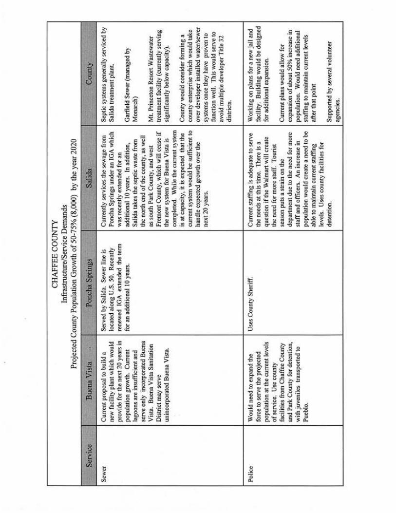
Sewer
The county does not operate any centralized sewage treatment facilities,and most rural developments are on septic systems. These systems areserviced by the Salida treatment plant. There are several package treat-ment plants in the county, one to serve Monarch and another in the Mt.Princeton area. There is growing concern that allowing proliferation ofpackage treatment plants to serve large rural subdivisions will lead towater quality problems because of poor maintenance by homeowner as-sociations. The City of Salida and the Buena Vista Sanitation District cur-rently operate treatment facilities for those respective areas. The City ofSalida’s treatment plant, which services Poncha Springs and takes septicwastes from unincorporated portions of Chaffee as well as South Park andWest Fremont Counties, is near capacity. However, if a new facility iscompleted in Buena Vista and takes some of this septic load, the citybelieves that it will have sufficient capacity to handle growth over thenext 20 years.
Chaffee County Comprehensive Plan20
The situation in Buena Vista is less defined. The current treatment facility,which consists only of a series of lagoons, has been cited for water pollu-tion violations. The Sanitation District is fully aware of these problems,and residents of the district recently approved a $4 million bond issue toupgrade the facility in 1997. The district has moved quickly to draw upplans for a new facility and has initiated discussion with the Buena VistaCorrectional Facility for joint participation in the upgrade.
Police/Sheriff
Both Buena Vista and Salida report that they would have to expand theirpolice forces to cope with additional growth within their communities.Poncha Springs currently is served by the Chaffee County Sheriff. All threejurisdictions utilize the county jail for detention. The current county jailis at or above capacity, but citizens defeated a proposal in 1998 to im-pose a 2% use tax on building materials purchased outside the county tofinance a new jail. The new facility would have covered a 50% increasein current county population. The county is now looking at alternativeapproaches to housing the growing number of prisoners.
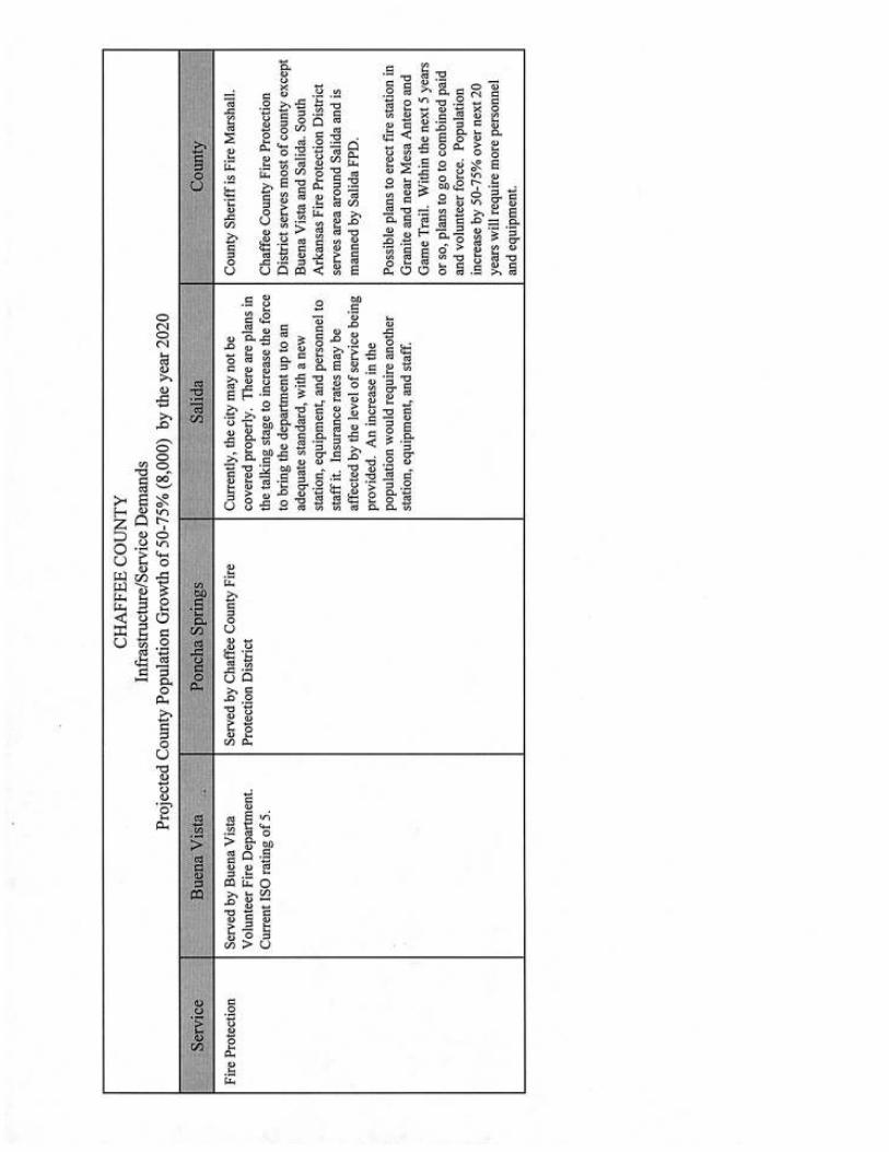
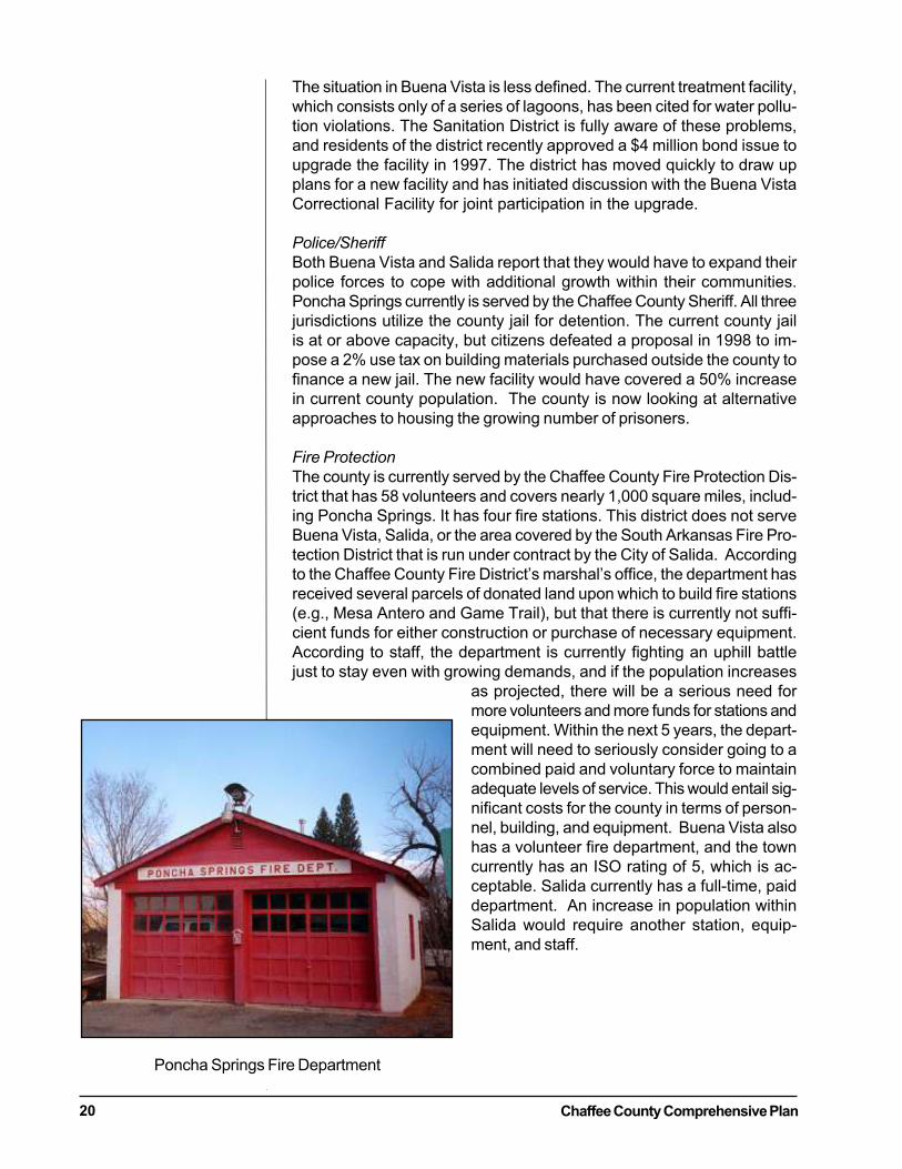
Fire Protection
The county is currently served by the Chaffee County Fire Protection Dis-trict that has 58 volunteers and covers nearly 1,000 square miles, includ-ing Poncha Springs. It has four fire stations. This district does not serveBuena Vista, Salida, or the area covered by the South Arkansas Fire Pro-tection District that is run under contract by the City of Salida. Accordingto the Chaffee County Fire District’s marshal’s office, the department hasreceived several parcels of donated land upon which to build fire stations(e.g., Mesa Antero and Game Trail), but that there is currently not suffi-cient funds for either construction or purchase of necessary equipment.According to staff, the department is currently fighting an uphill battlejust to stay even with growing demands, and if the population increases
as projected, there will be a serious need formore volunteers and more funds for stations andequipment. Within the next 5 years, the depart-ment will need to seriously consider going to acombined paid and voluntary force to maintainadequate levels of service. This would entail sig-nificant costs for the county in terms of person-nel, building, and equipment. Buena Vista alsohas a volunteer fire department, and the towncurrently has an ISO rating of 5, which is ac-ceptable. Salida currently has a full-time, paiddepartment. An increase in population withinSalida would require another station, equip-ment, and staff.
Poncha Springs Fire Department
Chaffee County Comprehensive Plan 21
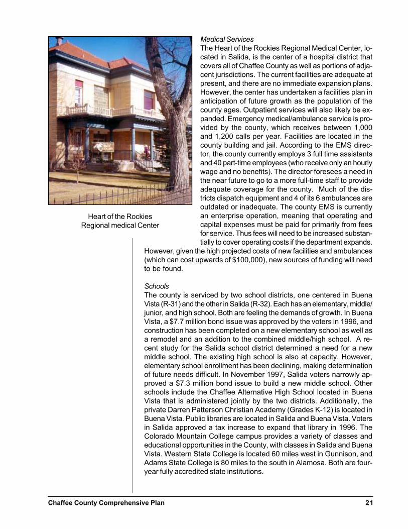
Medical Services
The Heart of the Rockies Regional Medical Center, lo-cated in Salida, is the center of a hospital district thatcovers all of Chaffee County as well as portions of adja-cent jurisdictions. The current facilities are adequate atpresent, and there are no immediate expansion plans.However, the center has undertaken a facilities plan inanticipation of future growth as the population of thecounty ages. Outpatient services will also likely be ex-panded. Emergency medical/ambulance service is pro-vided by the county, which receives between 1,000and 1,200 calls per year. Facilities are located in thecounty building and jail. According to the EMS direc-tor, the county currently employs 3 full time assistantsand 40 part-time employees (who receive only an hourlywage and no benefits). The director foresees a need inthe near future to go to a more full-time staff to provideadequate coverage for the county. Much of the dis-tricts dispatch equipment and 4 of its 6 ambulances areoutdated or inadequate. The county EMS is currentlyan enterprise operation, meaning that operating andcapital expenses must be paid for primarily from feesfor service. Thus fees will need to be increased substan-tially to cover operating costs if the department expands.
However, given the high projected costs of new facilities and ambulances(which can cost upwards of $100,000), new sources of funding will needto be found.
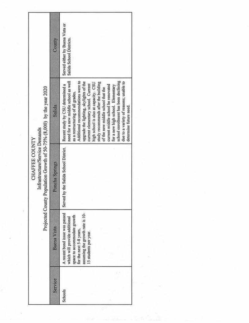
Schools
The county is serviced by two school districts, one centered in BuenaVista (R-31) and the other in Salida (R-32). Each has an elementary, middle/junior, and high school. Both are feeling the demands of growth. In BuenaVista, a $7.7 million bond issue was approved by the voters in 1996, andconstruction has been completed on a new elementary school as well asa remodel and an addition to the combined middle/high school. A re-cent study for the Salida school district determined a need for a newmiddle school. The existing high school is also at capacity. However,elementary school enrollment has been declining, making determinationof future needs difficult. In November 1997, Salida voters narrowly ap-proved a $7.3 million bond issue to build a new middle school. Otherschools include the Chaffee Alternative High School located in BuenaVista that is administered jointly by the two districts. Additionally, theprivate Darren Patterson Christian Academy (Grades K-12) is located inBuena Vista. Public libraries are located in Salida and Buena Vista. Votersin Salida approved a tax increase to expand that library in 1996. TheColorado Mountain College campus provides a variety of classes andeducational opportunities in the County, with classes in Salida and BuenaVista. Western State College is located 60 miles west in Gunnison, andAdams State College is 80 miles to the south in Alamosa. Both are four-year fully accredited state institutions.
Heart of the RockiesRegional medical Center
Chaffee County Comprehensive Plan22
Parks/Recreational Facilities
Unlike many counties in Colorado, Chaffee County does not currentlymaintain a formal park or recreation system or facilities such as camp-grounds. It has constructed and maintains a minimal system of trails, usu-ally associated with county roads. The county has recently undertakenan effort to plan a county wide trails system, a draft of which has beencompleted but not adopted. In the survey conducted as part of the com-prehensive plan process, a majority (56%) of respondents rated the avail-ability of developed indoor recreational facilities as poor. In contrast,87% were satisfied with outdoor recreational facilities or thought theywere good to excellent. Despite the lack of county facilities, citizens haveaccess to large tracts of state and federal lands for recreational purposesand hundreds of miles of developed trails and over 900 private and pub-lic campsites in the county. Additionally, the City of Salida and the Townof Buena Vista are working on trails and pathways throughout their com-munities. While the Buena Vista system does make connections with trailson public lands, the Salida system is primarily internal to the city.
Natural and Cultural Resources
Chaffee County has a tremendous bank of natural and cultural resourcessuch as abundant wildlife, scenic natural areas like the Chalk Cliffs, his-toric towns and sites, natural hot springs and pools, and blue-ribbon troutrivers and streams, to name only a few. These resources not only play acritical role in the county’s tourist economy, but also help define theessence of the area for residents. The county is home to some of thegreatest concentrations of wildlife in the United States. It is not unusual tobe able to see elk, deer, antelope, and big horn sheep in a single drivethrough the county, perhaps with a bald eagle or peregrine falcon wheel-ing overhead. While rarely seen, Chaffee County has a significant num-ber of mountain lions. The Arkansas River is not only a world-renownedwhite-water river, but also a blue-ribbon trout stream with a growing na-tional reputation.
The county has abundant surface water resources consisting of the Arkan-sas River and its tributaries such as Cottonwood, Chalk, Clear, and BrownsCreek and the South Arkansas River. Generally, the Arkansas and its tribu-taries have very high water quality, although there is some localized deg-radation from septic infiltration and sewage treatment facilities outflows.Recent efforts to clean up heavy mineral pollution in the upper Arkansasare already showing results with a major recovery of aquatic insects andlarger fish. The county has a number of larger reservoirs such as ClearCreek (surface area of 421 acres) and numerous mountain lakes. Thereare also over 700 miles of irrigation ditches in the county.
The Colorado Division of Wildlife has supplied the county with detailedmapping of critical habitat for a variety of wildlife species. This informa-tion is summarized in the map and wildlife species ranking list in Appen-dix D. Some of the most sensitive species are the peregrine falcon, baldeagle, and western boreal toad. The county also has critical habitat for avariety of other species including elk, deer, bighorn sheep, black bear,mountain lions, bobcat, wild turkey, and others.
Chaffee County Comprehensive Plan 23
The county is fortunate to have a number of un-usual scenic and natural features such as theChalk Cliffs near Mt. Princeton, the ruggedbackcountry of Browns Canyon, and the hotsprings and pools in Poncha Springs/Salida,Mount Princeton, and Cottonwood Creek, withothers scattered throughout the area. These alladd to the attractiveness and beauty of thecounty for tourists.
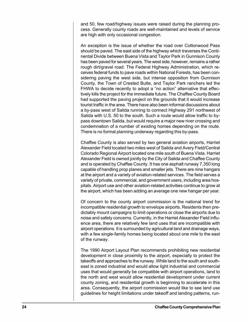
The county has a wealth of sites of historic andarcheological interest. A 1975 study commis-sioned by the county identified 74 sites to be ofsignificant historical interest. These range frommines, to historic cemeteries, to ghost townssuch as Turret. Of particular note is the town ofSt. Elmo, a national historic district. St. Elmo isone of Colorado’s best-preserved 1880’s min-ing towns. A number of structures in the townhave been renovated or stabilized, some with
funding from the state historical society. Currently, there are no land de-velopment or zoning regulations that protect these historic and archeo-logical resources in the county.
Transportation
Three major highways serve Chaffee County. U.S. Highway 50 is theprimary east/west link providing access to western Colorado and Inter-state 25 to the east at Pueblo. U.S. Highways 285/24 are the primarynorth/south link, and carries the lion’s share of traffic that comes to the
county from Denver and Colorado Springs. Traffic onboth of these highways has been increasing significantlyover the past 10 years. For example, traffic counts at theHighway 285/24 intersection at Johnson’s Cornerjumped 25% from 3,600 vehicles per day in1990 to4,500 in 1995. The increase was even higher on U.S.50 between Monarch Pass and Maysville, 48.6%. De-spite these increases, traffic flows continue to be goodthroughout the county, except perhaps in the summermonths when rafting buses mix with traffic on Highway285 to cause intermittent slowdowns and congestion.The county maintains approximately 540 miles of countyroads. It has 19 full-time road and bridge employeesand a road and bridge budget of about $1.68 millionannually. The state highway users tax provided about$1.3 million in revenues to the county in 1997. Be-cause of changes in the formula for distribution of thehighway users tax, the county administrator projects thatthere will be little increase in state funds for road/bridgemaintenance in the coming years. Aside from the in-creasing cost of road/bridge maintenance in the countyand the issue of speed limits on U.S. Highways 24, 285,
Mt. Princeton
St. Elmo Jail and Town Hall
Chaffee County Comprehensive Plan24
and 50, few road/highway issues were raised during the planning pro-cess. Generally county roads are well-maintained and levels of serviceare high with only occasional congestion.
An exception is the issue of whether the road over Cottonwood Passshould be paved. The east side of the highway which traverses the Conti-nental Divide between Buena Vista and Taylor Park in Gunnison Countyhas been paved for several years. The west side, however, remains a ratherrough dirt/gravel road. The Federal Highway Administration, which re-ceives federal funds to pave roads within National Forests, has been con-sidering paving the west side, but intense opposition from GunnisonCounty, the Town of Crested Butte, and Taylor Park ranchers led theFHWA to decide recently to adopt a “no action” alternative that effec-tively kills the project for the immediate future. The Chaffee County Boardhad supported the paving project on the grounds that it would increasetourist traffic in the area. There have also been informal discussions abouta by-pass west of Salida running to connect Highway 291 northwest ofSalida with U.S. 50 to the south. Such a route would allow traffic to by-pass downtown Salida, but would require a major new river crossing andcondemnation of a number of existing homes depending on the route.There is no formal planning underway regarding this by-pass.
Chaffee County is also served by two general aviation airports, HarrietAlexander Field located two miles west of Salida and Avery Field/CentralColorado Regional Airport located one mile south of Buena Vista. HarrietAlexander Field is owned jointly by the City of Salida and Chaffee Countyand is operated by Chaffee County. It has one asphalt runway 7,350 longcapable of handling prop planes and smaller jets. There are nine hangarsat the airport and a variety of aviation-related services. The field serves avariety of private, commercial, and government users, including area hos-pitals. Airport use and other aviation-related activities continue to grow atthe airport, which has been adding an average one new hangar per year.
Of concern to the county airport commission is the national trend forincompatible residential growth to envelope airports. Residents then pre-dictably mount campaigns to limit operations or close the airports due tonoise and safety concerns. Currently, in the Harriet Alexander Field influ-ence area, there are relatively few land uses that are incompatible withairport operations. It is surrounded by agricultural land and drainage ways,with a few single-family homes being located about one mile to the eastof the runway.
The 1990 Airport Layout Plan recommends prohibiting new residentialdevelopment in close proximity to the airport, especially to protect thetakeoffs and approaches to the runway. While land to the south and south-east is zoned industrial and would allow light industrial and commercialuses that would generally be compatible with airport operations, land tothe north and west would allow residential development under currentcounty zoning, and residential growth is beginning to accelerate in thisarea. Consequently, the airport commission would like to see land useguidelines for height limitations under takeoff and landing patterns, run-
Chaffee County Comprehensive Plan 25
way clear zones, and use restrictions to protect against noise impacts thatare set forth in the airport land use plan. These types of land use limita-tions are standard for airports around the United States to protect airportsfrom incompatible encroachment and to obviate noise and safety con-cerns. Future revisions of the county zoning and subdivision resolutionsshould create an airport overlay zone to address these issues.
A second county airport is Avery Field/Central Colorado Regional Airportsouth of Buena Vista, which is owned by the City of Buena Vista andoperated by Arkansas Valley Aviation, a private firm. The field consists ofone asphalt runway that runs north and south. It is 8,300 feet long and iscurrently 75 feet in width, with plans to expand it to 100 feet. The field isequipped with runway lighting for night operations and a beacon andlanding guidance lights. Privately owned hangars provide approximately25,000 square feet of hangar space. Fuel service is available during day-light hours. The airport serves a mix of private, commercial, and govern-ment users, including fire fighting, search and rescue, and emergencymedical operations. The Colorado Department of Corrections uses thefield as a base for transportation and exchange of prisoners from correc-tion facilities.
The Town of Buena Vista controls approximately 26 acres of land alongthe taxiways that could accommodate a large additional amount of han-gar space plus industrial development. Also, there are approximately an-other 120 acres of private land abutting the town property that is avail-able for development.
The Avery Field/Central Colorado Regional Airport master plan providesfor this land to be utilized for fly-in industrial/business or residential airpark use. The plan also provides for a buffer between potential residentialgrowth near the airport. According to the airport operator, the airportadvisory board and the town are reasonably comfortable that planning inthe immediate vicinity of the airfield has been appropriately addressed byairport overlay zoning in the city, avigation easements, buffer areas, andairport operational rules. The east side of the field are buffered by theHighway 24/285 corridor, a railroad right-of-way, and the correctionalfacility. On the north, there is over a half mile of publicly owned wet-lands between the runway and town limits where residential develop-ment has taken place. On the west the airfield is flanked by a county roadand extensive business/industrial development land. West and south ofthe county road is agricultural land except for about 500 acres of industri-ally zoned land at the northwest corner of the airfield in various stages ofdevelopment.

Chaffee County Comprehensive Plan26
Chaffee County Comprehensive Plan 27
4. LAND USE AND DEVELOPMENT PATTERNS
DISCUSSION
Residential Development
Perhaps the most important objective of the plan is to focus new higherdensity residential development around existing towns and developedareas. An overwhelming majority of the county’s citizens, 76%, disap-prove of continuing the county’s current development pattern of scat-tered small and large lots in rural areas. An almost equal number favortargeting smaller lot development around towns and allowing only largerlot development in rural areas. If carried out, this goal would help ac-complish several things.
First, it would make providing governmental services like fire protection,roads, and water/sewage service, more efficient and cost-effective, help-ing to keep taxes down. Property taxes, particularly for commercial prop-erty, in Chaffee County continue to climb to pay for the costs of newdevelopment. Also, as documented in Appendix D, services such as fireprotection are being stretched by increasing development in unincorpo-rated areas.
Second, it would make preservation of the county’s rural character mucheasier since rural areas would not be fragmented with more small lot (1unit/2-3 acres and less) residential development. Today, the county’srural zone districts are rural in name only. They allow development asdense as permitted in residential zones near towns designed to accom-modate higher intensity projects. According to county staff, until 1990,the rural zone districts required a minimum lot size of 1 unit/10 acres.This change was made despite the fact that it directly contradicted the-then existing comprehensive plan which also called for smaller lot devel-opment to be focused around the towns. (Comprehensive Plan of ChaffeeCounty, Yguado Association, April 1971)
Finally, focusing development would help address the affordable hous-ing problem in Chaffee County. Again, it is important to note that thepresent scattered-lot development pattern is not producing and will notproduce affordable housing lots for existing residents of the county.
Landowners within designated growth areas have also expressed concernthat they will be forced to develop their property at higher densities. Thiswould not be the case. They would have the ability to develop at higherdensities, but could, if they choose, not to develop at all or at much lowerdensities. Indeed, experience in other communities indicates that therewill be a variety of lot sizes within the targeted growth areas, and that lotsizes will be larger the greater the distance from the towns.
Commercial and Industrial Development
While it is ostensibly the county’s policy as reflected in its zoning resolu-tion to encourage commercial and industrial development in or adjacent
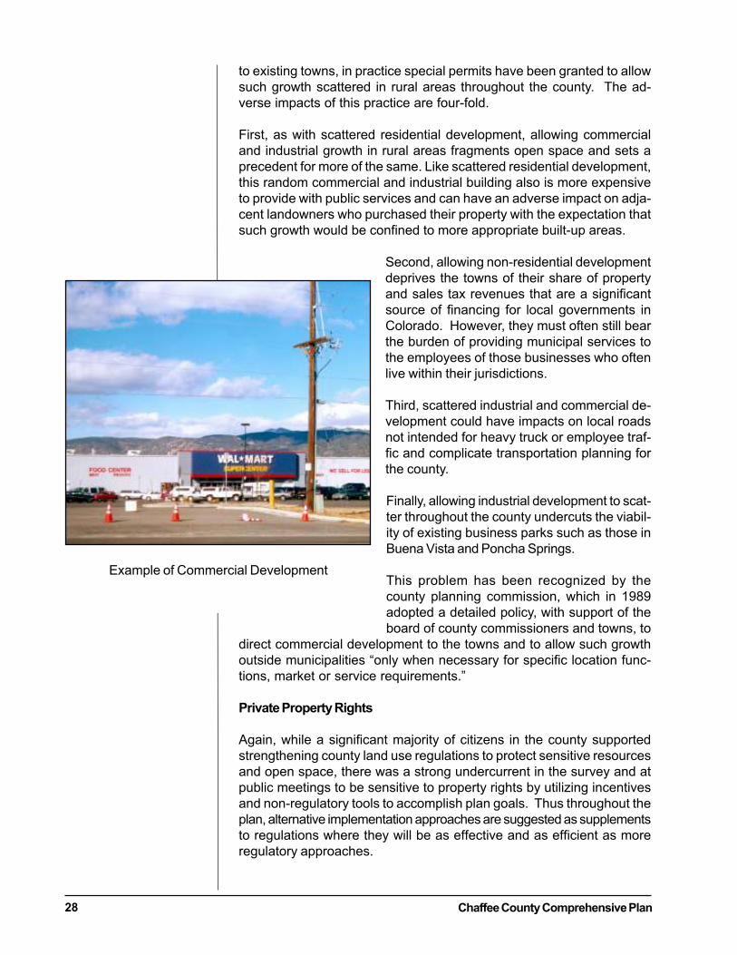
Chaffee County Comprehensive Plan28
to existing towns, in practice special permits have been granted to allowsuch growth scattered in rural areas throughout the county. The ad-verse impacts of this practice are four-fold.
First, as with scattered residential development, allowing commercialand industrial growth in rural areas fragments open space and sets aprecedent for more of the same. Like scattered residential development,this random commercial and industrial building also is more expensiveto provide with public services and can have an adverse impact on adja-cent landowners who purchased their property with the expectation thatsuch growth would be confined to more appropriate built-up areas.
Second, allowing non-residential developmentdeprives the towns of their share of propertyand sales tax revenues that are a significantsource of financing for local governments inColorado. However, they must often still bearthe burden of providing municipal services tothe employees of those businesses who oftenlive within their jurisdictions.
Third, scattered industrial and commercial de-velopment could have impacts on local roadsnot intended for heavy truck or employee traf-fic and complicate transportation planning forthe county.
Finally, allowing industrial development to scat-ter throughout the county undercuts the viabil-ity of existing business parks such as those inBuena Vista and Poncha Springs.
This problem has been recognized by thecounty planning commission, which in 1989adopted a detailed policy, with support of theboard of county commissioners and towns, to
direct commercial development to the towns and to allow such growthoutside municipalities “only when necessary for specific location func-tions, market or service requirements.”
Private Property Rights
Again, while a significant majority of citizens in the county supportedstrengthening county land use regulations to protect sensitive resourcesand open space, there was a strong undercurrent in the survey and atpublic meetings to be sensitive to property rights by utilizing incentivesand non-regulatory tools to accomplish plan goals. Thus throughout theplan, alternative implementation approaches are suggested as supplementsto regulations where they will be as effective and as efficient as moreregulatory approaches.
Example of Commercial Development
Chaffee County Comprehensive Plan 29
At the various citizen workshops, a recurrent theme was concern overthe high percentage (83%) of land in public ownership. Some propertyowners asked why any more land should be taken off the tax roles andput in public ownership to preserve open space, when so much wasalready in the public domain. Others worried that there was not enoughprivate land to sustain a solid economy. Interestingly, since the 1971comprehensive plan was completed, the amount of land in federal own-ership has actually decreased slightly according to information com-piled for the Valley Visions Chaffee County Healthy Community Profile in1995.A related theme was that as the county continues to urbanize, ranchersare finding it more and more difficult to maintain their operations withoutvarious forms of interference from adjacent developments. A particularlyimportant area that ranchers singled out for action was the protection ofirrigation ditch rights and the need for convenient access to those ditchesfor maintenance.
GUIDING OBJECTIVE 1.
Focus new higher density residential development around existing towns.
IMPLEMENTATION ACTION
1. Amend the county rural zoning regulations to establish a base densityspecific to the zone for areas outside the designated growth areas tomore effectively accomplish the stated objectives outlined in the cur-rent zoning resolution and facilitate development toward the desig-nated growth areas. Provide for site specific adjustments and incen-tives to the base density following criteria to be established.
· Subdivision regulations will be modified and coordinated to reflectcurrent zoning resolutions as amended. Additional factors whichwould allow adjustment of the above suggested base density shouldinclude:
· Access to public or private water and sewer systems;· Impact to riparian areas;· Accommodation of planned trails;· Inclusion of facilities accessible to subdivision residents;· Level of developer provided improvements (paved roads, water sys-
tems, utilities provided, facilities, etc.); and· Impact on wildlife corridor.
2. Work in close cooperation with the three municipalities to designatetown areas where smaller-lot, more affordable residential develop-ment will be appropriate. These areas should take into account suchfactors as population projections, topography and location of sensi-tive environmental areas (e.g., do not include critical wildlife habi-tat), and location of existing and planned municipal services. Poten-tial development densities in these areas adjacent to the towns shouldbe increased to encourage and have compact development near ex-isting housing. As a part of this process, the town and county should
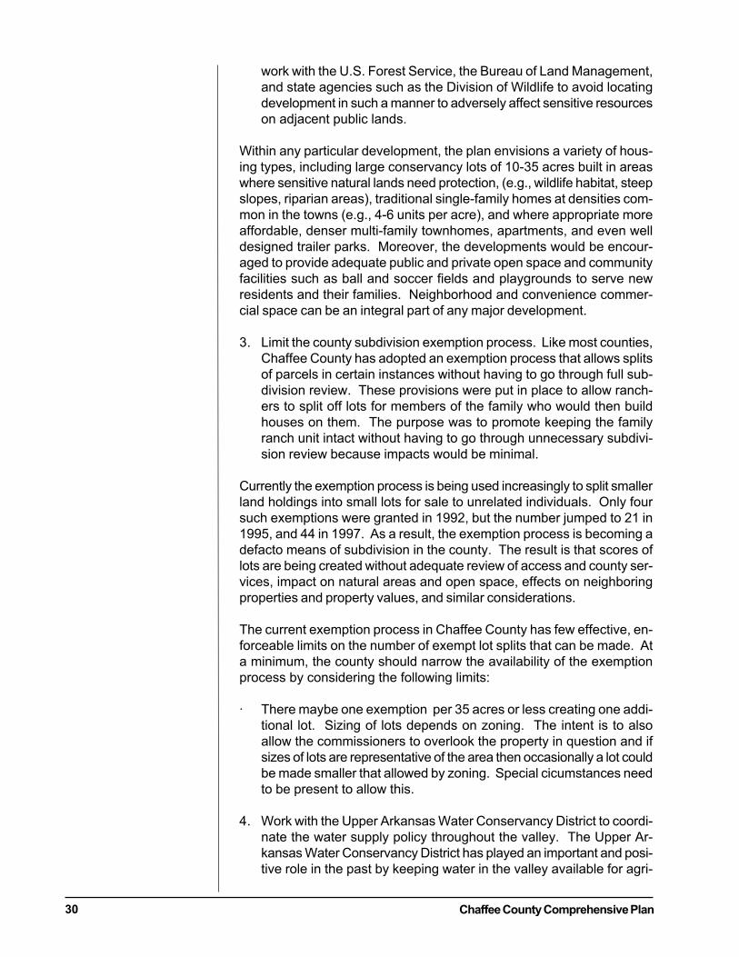
Chaffee County Comprehensive Plan30
work with the U.S. Forest Service, the Bureau of Land Management,and state agencies such as the Division of Wildlife to avoid locatingdevelopment in such a manner to adversely affect sensitive resourceson adjacent public lands.
Within any particular development, the plan envisions a variety of hous-ing types, including large conservancy lots of 10-35 acres built in areaswhere sensitive natural lands need protection, (e.g., wildlife habitat, steepslopes, riparian areas), traditional single-family homes at densities com-mon in the towns (e.g., 4-6 units per acre), and where appropriate moreaffordable, denser multi-family townhomes, apartments, and even welldesigned trailer parks. Moreover, the developments would be encour-aged to provide adequate public and private open space and communityfacilities such as ball and soccer fields and playgrounds to serve newresidents and their families. Neighborhood and convenience commer-cial space can be an integral part of any major development.
3. Limit the county subdivision exemption process. Like most counties,Chaffee County has adopted an exemption process that allows splitsof parcels in certain instances without having to go through full sub-division review. These provisions were put in place to allow ranch-ers to split off lots for members of the family who would then buildhouses on them. The purpose was to promote keeping the familyranch unit intact without having to go through unnecessary subdivi-sion review because impacts would be minimal.
Currently the exemption process is being used increasingly to split smallerland holdings into small lots for sale to unrelated individuals. Only foursuch exemptions were granted in 1992, but the number jumped to 21 in1995, and 44 in 1997. As a result, the exemption process is becoming adefacto means of subdivision in the county. The result is that scores oflots are being created without adequate review of access and county ser-vices, impact on natural areas and open space, effects on neighboringproperties and property values, and similar considerations.
The current exemption process in Chaffee County has few effective, en-forceable limits on the number of exempt lot splits that can be made. Ata minimum, the county should narrow the availability of the exemptionprocess by considering the following limits:
· There maybe one exemption per 35 acres or less creating one addi-tional lot. Sizing of lots depends on zoning. The intent is to alsoallow the commissioners to overlook the property in question and ifsizes of lots are representative of the area then occasionally a lot couldbe made smaller that allowed by zoning. Special cicumstances needto be present to allow this.
4. Work with the Upper Arkansas Water Conservancy District to coordi-nate the water supply policy throughout the valley. The Upper Ar-kansas Water Conservancy District has played an important and posi-tive role in the past by keeping water in the valley available for agri-

Chaffee County Comprehensive Plan 31
cultural irrigation, local businesses, and residences. The districthelped keep a number of existing businesses in operation in the 1990swhen they were faced with well enforcement orders by the statewater engineer. District officials report they have worked with Salida,Buena Vista, and Poncha Springs to help those communities se-cure adequate water supplies and water storage capacity.
5. Execute an intergovernmental agreement (IGA) between the countyand towns that adopts a policy, of supporting annexation of land tothe town for projects of higher density. Encouraging steps have al-ready been taken by the county in signing an intergovernmental plan-ning agreement with Buena Vista and Poncha Springs. These agree-ments should be modified and expanded to reflect the objectives ofthis plan, and renewed efforts made to sign such an agreement withSalida.
The IGA should also address the issue of commercial/industrial develop-ment around the towns. Adequate provision should be made to accom-modate some additional highway oriented development near the towns,but steps should be taken to ensure that strip development does not oc-cur out along the gateways so that Poncha Springs and Salida and BuenaVista and Johnson Village do not sprawl into one another. Industrial andservice oriented commercial development should be concentrated in ex-isting business parks in Poncha Springs and Buena Vista or on infill lots inthe towns themselves.
GUIDING OBJECTIVE 2.
Focus commercial and industrial development in existing towns, devel-oped industrial parks, and already developed commercial areas in placeslike Nathrop and other designated areas.
IMPLEMENTING ACTIONS
1. Review the county’s zone districts to modify the number of commer-cial uses that are allowed in rural areas through the special permitprocess. Allow only those uses that have an obvious need to locatein such areas such as certain resorts/dude ranches, commercial raft-ing, and resource extraction activities.
2. Adopt and codify in the county zoning regulations commercial devel-opment policies.
GUIDING OBJECTIVE 3.
Protect existing private property rights in adopting any regulatory changesbased on this plan.
Chaffee County Comprehensive Plan32
IMPLEMENTING ACTIONS
1. Existing legal subdivided lots should be “grandfathered” in againstany locational controls on development that might be adopted toimplement this plan.
GUIDING OBJECTIVE 4.
Use incentives and other non-regulatory tools to accomplish plan objec-tives where they will be effective and efficient.IMPLEMENTING ACTION
1. Utilize incentives and non-regulatory tools to guide developmentwithin the County. Tools include density bonuses, the conservationsubdivision process, and purchase of development rights, if enacted.
2. Encourage creation of a private land trust for the county and the for-mation of a privately directed purchase of development rights to pre-serve open space and ranch land throughout the county.
GUIDING OBJECTIVE 5.
Maintain the existing stock of private land in the county and encouragecontinuation of agricultural activities.
IMPLEMENTING ACTIONS
1. Adopt a “no net loss” of private land policy for the county. Workwith federal and state agencies to ensure that when private land ispurchased and converted to public uses, that where feasible an equiva-lent amount of public lands are made available for development. Forexample, if the United States Forest Service purchases land to providea buffer for resources inside San Isabel National Forest, it should de-termine if there are equivalent amounts of excess public lands thatcan be traded or sold without impairing forest resources.
2. Enact strengthened local “right-to-farm” legislation as authorized bystate law that will protect ranchers and farmers from nuisance suitsand other interferences by surrounding development.
3. Develop specific standards requiring protection of access to existingC.R.S. irrigation ditches throughout Chaffee County per C.R.S. 37-86-
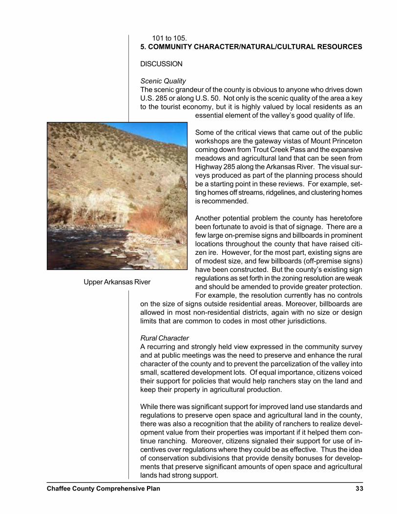
Chaffee County Comprehensive Plan 33
101 to 105.5. COMMUNITY CHARACTER/NATURAL/CULTURAL RESOURCES
DISCUSSION
Scenic Quality
The scenic grandeur of the county is obvious to anyone who drives downU.S. 285 or along U.S. 50. Not only is the scenic quality of the area a keyto the tourist economy, but it is highly valued by local residents as an
essential element of the valley’s good quality of life.
Some of the critical views that came out of the publicworkshops are the gateway vistas of Mount Princetoncoming down from Trout Creek Pass and the expansivemeadows and agricultural land that can be seen fromHighway 285 along the Arkansas River. The visual sur-veys produced as part of the planning process shouldbe a starting point in these reviews. For example, set-ting homes off streams, ridgelines, and clustering homesis recommended.
Another potential problem the county has heretoforebeen fortunate to avoid is that of signage. There are afew large on-premise signs and billboards in prominentlocations throughout the county that have raised citi-zen ire. However, for the most part, existing signs areof modest size, and few billboards (off-premise signs)have been constructed. But the county’s existing signregulations as set forth in the zoning resolution are weakand should be amended to provide greater protection.For example, the resolution currently has no controls
on the size of signs outside residential areas. Moreover, billboards areallowed in most non-residential districts, again with no size or designlimits that are common to codes in most other jurisdictions.
Rural Character
A recurring and strongly held view expressed in the community surveyand at public meetings was the need to preserve and enhance the ruralcharacter of the county and to prevent the parcelization of the valley intosmall, scattered development lots. Of equal importance, citizens voicedtheir support for policies that would help ranchers stay on the land andkeep their property in agricultural production.
While there was significant support for improved land use standards andregulations to preserve open space and agricultural land in the county,there was also a recognition that the ability of ranchers to realize devel-opment value from their properties was important if it helped them con-tinue ranching. Moreover, citizens signaled their support for use of in-centives over regulations where they could be as effective. Thus the ideaof conservation subdivisions that provide density bonuses for develop-ments that preserve significant amounts of open space and agriculturallands had strong support.
Upper Arkansas River
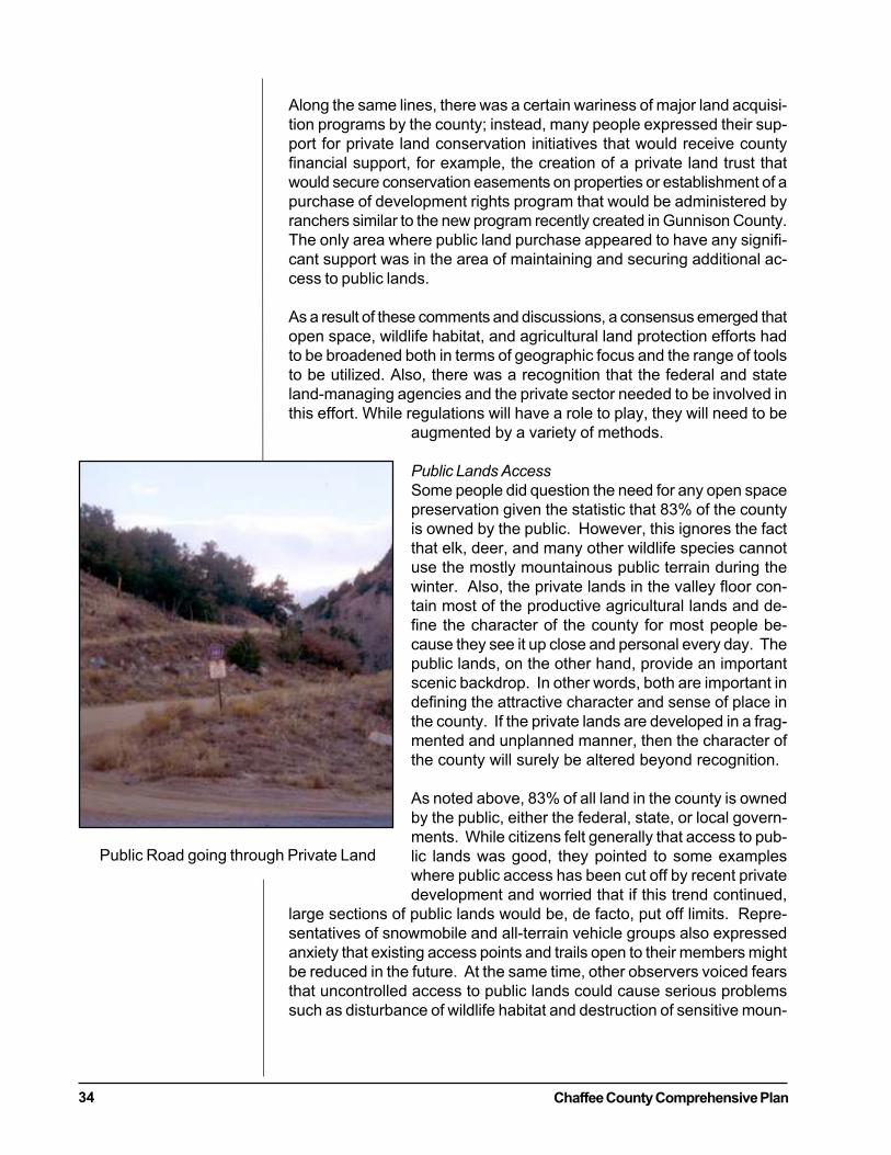
Chaffee County Comprehensive Plan34
Along the same lines, there was a certain wariness of major land acquisi-tion programs by the county; instead, many people expressed their sup-port for private land conservation initiatives that would receive countyfinancial support, for example, the creation of a private land trust thatwould secure conservation easements on properties or establishment of apurchase of development rights program that would be administered byranchers similar to the new program recently created in Gunnison County.The only area where public land purchase appeared to have any signifi-cant support was in the area of maintaining and securing additional ac-cess to public lands.
As a result of these comments and discussions, a consensus emerged thatopen space, wildlife habitat, and agricultural land protection efforts hadto be broadened both in terms of geographic focus and the range of toolsto be utilized. Also, there was a recognition that the federal and stateland-managing agencies and the private sector needed to be involved inthis effort. While regulations will have a role to play, they will need to be
augmented by a variety of methods.
Public Lands Access
Some people did question the need for any open spacepreservation given the statistic that 83% of the countyis owned by the public. However, this ignores the factthat elk, deer, and many other wildlife species cannotuse the mostly mountainous public terrain during thewinter. Also, the private lands in the valley floor con-tain most of the productive agricultural lands and de-fine the character of the county for most people be-cause they see it up close and personal every day. Thepublic lands, on the other hand, provide an importantscenic backdrop. In other words, both are important indefining the attractive character and sense of place inthe county. If the private lands are developed in a frag-mented and unplanned manner, then the character ofthe county will surely be altered beyond recognition.
As noted above, 83% of all land in the county is ownedby the public, either the federal, state, or local govern-ments. While citizens felt generally that access to pub-lic lands was good, they pointed to some exampleswhere public access has been cut off by recent privatedevelopment and worried that if this trend continued,
large sections of public lands would be, de facto, put off limits. Repre-sentatives of snowmobile and all-terrain vehicle groups also expressedanxiety that existing access points and trails open to their members mightbe reduced in the future. At the same time, other observers voiced fearsthat uncontrolled access to public lands could cause serious problemssuch as disturbance of wildlife habitat and destruction of sensitive moun-
Public Road going through Private Land

Chaffee County Comprehensive Plan 35
tain vegetation.Recreational Opportunities
Unlike a growing number of mountain counties, Chaffee County doesnot provide its citizens with county parks or open space. However, withthe combination of federal and state lands and local and private recre-ational facilities, it is not surprising that many citizens of Chaffee Countyare generally pleased with outdoor recreational opportunities and facili-ties. The County should negotiate for school property in order to provideparks through the County.
Moreover, there was little support for the county taking steps to promotemore active recreational opportunities such as rafting. The majority ofChaffee County residents support more emphasis on passive recreation,such as fishing, hiking, and snowshoeing.
However, there was significant disenchantment over indoor recreationalopportunities. 56% of respondents thought that they were below averageto poor. Neither the county nor the three towns have any major multi-purpose indoor community recreational facility. The Salida Hot SpringsPool is definitely an important asset and is heavily used. However, giventhe fact that efforts to create recreational districts in both Salida and BuenaVista have been defeated during the last decade, the question remainswhether citizens are willing to fund such a facility. Also at issue wouldbe whether a public facility would compete with private facilities.
Natural Resources
As discussed above, Chaffee County is blessed with abundant wildlife,wonderful views, and other natural assets that in a very real way definethe community’s character. An impressive 77% of survey respondents
said wildlife habitat should be given priority in the pro-tection of open space. Even more, 79%, said protec-tion of river corridors and wetlands was critical. 63%of all respondents support stronger county land useregulations to accomplish these goals, and 70% sup-ported economic incentives for ranchers to protectopen space.
Protection of Sensitive Natural Areas
In addition to protection of wildlife habitat and ripar-ian, steps should be taken to protect sensitive naturalareas such as ridge lines and steep slopes from incom-patible development and to encourage landowners anddevelopment, through incentives, to preserve such ar-eas. Development on such sensitive areas, while oftenvery visually intrusive, can also cause serious soil ero-sion and the potential for safety problems if those areasare unstable. Also, while the county currently has someminimum regulations regarding wildfire protection, withthe increasing amount of development scatteredthroughout forested areas, these provisions need to be
St. Elmo Post Office
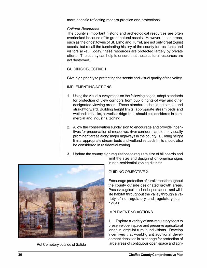
Chaffee County Comprehensive Plan36
more specific reflecting modern practice and protections.
Cultural Resources
The county’s important historic and archeological resources are oftenoverlooked because of its great natural assets. However, these areas,such as the ghost towns of St. Elmo and Turret, are not only great touristassets, but recall the fascinating history of the county for residents andvisitors alike. Today, these resources are protected largely by privateefforts. The county can help to ensure that these cultural resources arcnot destroyed.
GUIDING OBJECTIVE 1.
Give high priority to protecting the scenic and visual quality of the valley.
IMPLEMENTING ACTIONS
1. Using the visual survey maps on the following pages, adopt standardsfor protection of view corridors from public rights-of way and otherdesignated viewing areas. These standards should be simple andstraightforward. Building height limits, appropriate stream beds andwetland setbacks, as well as ridge lines should be considered in com-mercial and industrial zoning.
2. Allow the conservation subdivision to encourage and provide incen-tives for preservation of meadows, river corridors, and other visuallyprominent areas along major highways in the county. Building heightlimits, appropriate stream beds and wetland setback limits should alsobe considered in residential zoning.
3. Update the county sign regulations to regulate size of billboards andlimit the size and design of on-premise signsin non-residential zoning districts.
GUIDING OBJECTIVE 2.
Encourage protection of rural areas throughoutthe county outside designated growth areas.Preserve agricultural land, open space, and wild-life habitat throughout the valley through a va-riety of nonregulatory and regulatory tech-niques.
IMPLEMENTING ACTIONS
1. Explore a variety of non-regulatory tools topreserve open space and preserve agriculturallands in large-lot rural subdivisions. Developincentives that would grant additional devel-opment densities in exchange for protection oflarge areas of contiguous open space and agri-Pet Cemetery outside of Salida
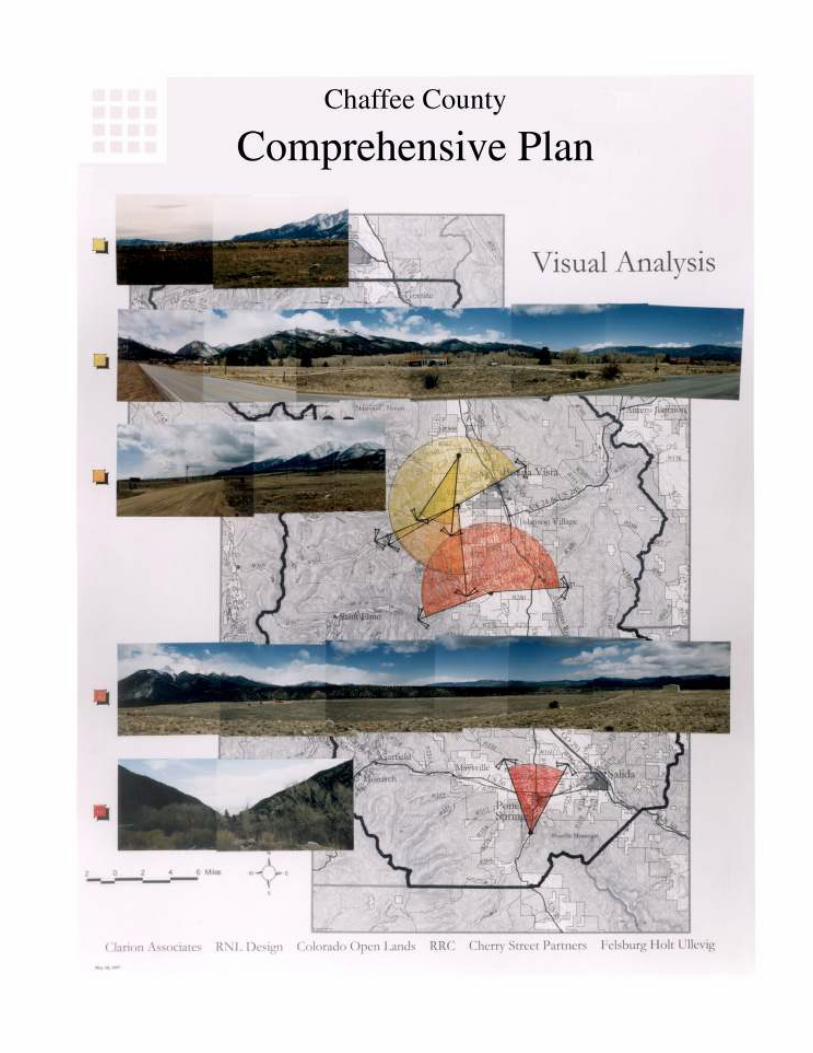

Chaffee County Comprehensive Plan 37
cultural lands.
2. Assist in the creation of a private land conservation organization thatcan utilize public/private conservation measures such as donation ofconservation. Funding might come from the county, Great OutdoorsColorado, and other sources. Purchase would be undertaken only ona willing seller basis with a goal of keeping land in productive agri-cultural use where possible.
3. A small county fund could be created for public purchase of trailrights-of-way, particularly to maintain and secure access to public lands.This could be funded in part by contributions of money in-lieu ofland dedication requirements or impact fees.
GUIDING OBJECTIVES 3.
Provide access to public lands and river/stream corridors.
IMPLEMENTING ACTIONS
1. Identify key access points to public lands that should be maintainedor improved. Use a variety of techniques such as development incen-tives, acquisition of development rights, or donation of access ease-ments to preserve and enhance such access.
2. Require that all development applications for property adjacent topublic lands take special steps to ensure appropriate public access ismaintained, improved, or limited as appropriate, including:
· Pre-application consultation with relevant state and federal land man-agement agencies to discuss issues such as appropriate travel/use re-strictions, land tenure adjustments, site development, hunting on pub-lic lands, and similar issues that would affect adjacent public lands aswell as residents of the development.
· A written agreement with the land management agencies that con-tains specific proposals to provide or limit access as appropriate giventhe existing character, environmental sensitivity, and use of adjacentpublic lands.
· Dedication of public rights-of-way, either in-fee or by easement, toensure public access that is determined to be appropriate.
3. Work with the Bureau of Land Management and the United StatesForest Service to amend the applicable resource management andforest plans to reflect the goals and implementing actions set forth inthis plan.
4. Complete the comprehensive trails plan for the valley that identifiespotential trail corridors, trailhead access points to public lands, andassociated sites for recreational activities. Pursue funding for imple-
Chaffee County Comprehensive Plan38
mentation of such an interjurisdictional trails/open space plan withthe Great Outdoors Colorado Trust Fund and similar sources.
GUIDING OBJECTIVE 4.
Preserve and enhance critical wildlife habitat and river and stream corri-dors throughout the county.
IMPLEMENTING ACTIONS
1. Develop and adopt special wildlife habitat protection incentives and/or regulations to be applied in the subdivision and zoning reviewprocesses. Areas to be protected should include migration routes,breeding areas, critical winter range for big game, riparian zones, andsimilar sensitive areas as identified by the Colorado Division of Wild-life on its comprehensive wildlife maps. The county should codify aprocess by which all development requests are referred to the Divi-sion of Wildlife for review and comment. Subdivision and zoningregulations should be amended to give the planning commission theability to consider and impose controls on fencing, keeping of pets(especially dogs) in developments near or within critical wildlife ar-eas, and animal resistant trash receptacles. The Chaffee County WeedControl Officer should be consulted for any vegetation concerns. Also,consideration should be given to the fact that certain public lands areused for hunting so that development should be situated to avoidpotential safety problems.
2. In the development review and annexation processes, require thatsensitive wildlife habitats be identified and, to the maximum extentfeasible, be protected by setting aside such areas.
3. Adopt new regulations to complement existing federal and state lawsby requiring development to set back from wetlands, rivers, streams,and other aquatic resources a minimum distance of 100 feet to pre-serve vegetative habitat and protect water quality by reducing sedi-mentation from runoff.
4. Consider vegetation and tree protection standards that require devel-opers of larger projects to document the extent and type of vegetativecover on a site and identify steps to be taken to preserve a specifiedpercentage of such cover and mitigate any adverse impacts that can-not be avoided.
5. Explore development incentives such as various subdivision tech-niques, a transferable development rights, and development rightsacquisition to encourage and assist landowners in the protection ofcritical natural areas.
GUIDING OBJECTIVE 5.
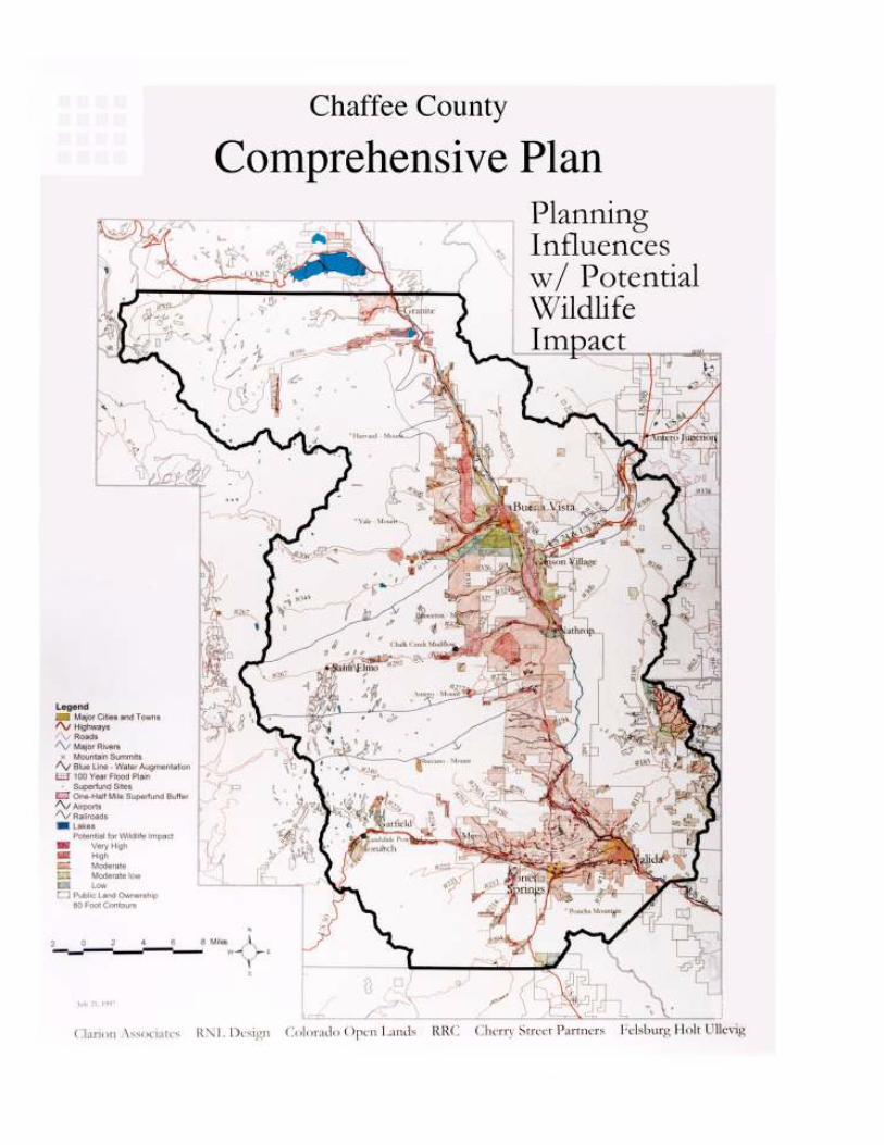
Chaffee County Comprehensive Plan 39
Protect other sensitive natural areas (see map on the following page).
IMPLEMENTING ACTIONS
1. Augment existing county standards for development on steep slopesand other potential hazard areas, including:
· More specific standards defining when steep slopes and hazard areasare inappropriate
· Revegetation of disturbed areas and controls on cutting of steep slopesto provide road access.
2. Develop incentives regarding the location and design of developmentthat would penetrate the skyline and be visible from public rights-of-ways, parks and open space, and subdivisions so as to maintain thenatural appearance and character of the study area. Steps to be takenmight include special height controls, providing clustering bonusesfrom landowners who preserve designated sensitive ridge lines, andacquisition of key parcels that are critical to protection of designatedsensitive viewsheds.
3. Protect the character of natural areas and the existing “dark sky” bypreparing and adopting exterior night lighting standards that ensurethat lighting is directed downward in such a manner to reduce, to themaximum extent feasible, negative impact on the night sky.
4. Discourage significant alteration of the boundaries or disturbance ofany vegetation within floodplains.
5. Adopt more specific wildfire regulations to help ensure that develop-ment avoids areas of high wildfire potential and that steps are taken toprotect structures from potential fire damage. Areas to be addressedinclude restricting the use of wood shingles, requiring dear zonesaround homes in hazard areas within which vegetation is removed,and similar measures being adopted in many other jurisdictions. Seemap on the following page.
GUIDING OBJECTIVE 6.
Protect cultural resources.
IMPLEMENTING ACTIONS
1. Pursue an updated survey of significant historic and archeologicalsites in the county so that developers and the planning commissionhave adequate information in the development review process.
2. Adopt standards, procedures, and incentives in the subdivision andzoning regulations to encourage the preservation and renovation

Chaffee County Comprehensive Plan40
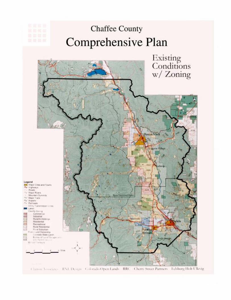
Chaffee County Comprehensive Plan 41
(where appropriate) of historic structures and sites and archeologi-cal resources.
6. TRANSPORTATION
DISCUSSION
Development and Roads
Perhaps because levels of service are generally excellent and there is littleroad congestion in Chaffee County, the cost of maintaining existing countyroads, culverts, and bridges and construction of new roads to serve newsubdivisions were of greater concern.
Citizens who responded to the survey overwhelmingly expressed sup-port for measures that would recoup from new development a fair shareof the cost of new facilities that need to be constructed to serve it. Lead-ers of the real estate community also stated their support for equitablecost recovery mechanisms so that the cost of new development was notshifted to existing residents through higher property taxes or other feesand charges.
Alternative Modes of Transportation
Although rail and air service is limited, steps should be taken to preservethese transportation options. The success of short line railroads in otherstates indicates that the county should not assume that additional railservice is impossible. While there is currently no scheduled commercialair service in Chaffee County, increasingly service businesses and thosewith high value-to-weight products use air service to transport packagesand goods in other locales. Steps need to be considered so that existingairport capacity is not constrained in a way that may hamper expansion ofservice in the future
GUIDING OBJECTIVE 1.
Ensure that adequate roads are available to service Chaffee County’s ex-isting and future residents and that development pays the cost of roadimprovements it necessitates.
IMPLEMENTATION ACTIONS
1. Prepare a roadway plan for the county that identifies road and bridgeupgrades and new construction that will be needed for the Countyover the next twenty years; set priorities among such improvementsand projects; and identifies funding sources. This plan should con-centrate county capital investments on roads in the growth areas aroundthe three municipalities so that future growth can be accommodatedin these preferred development areas. Extension of new roads intosensitive environmental areas should be avoided.
2. Require transportation impact analyses and mitigation measures forall major subdivisions greater than 10 lots and larger commercial de-
Chaffee County Comprehensive Plan42
velopments (e.g., greater than 25,000 square feet).
3. Revise county subdivision road standards to address drainage, impacton the environment (e.g., soil erosion, cut and fill, etc.), and longterm maintenance.
GUIDING OBJECTIVE 2.
Preserve options for alternative modes of transportation such as rail andair so that Chaffee County does not become totally dependent on roadsfor access.
IMPLEMENTING ACTIONS
1. Amend the county zoning resolution and map to establish airport
Chaffee County Comprehensive Plan 43
overlay zones that protect the airports from encroachment by in-compatible development and address noise and safety concerns.
7. AFFORDABLE HOUSING
DISCUSSION
Affordable housing emerged during the citizen participation process andcounty wide survey as an important issue. Over 81% of respondents tothe survey said it was a problem in Chaffee County. Serious concernswere expressed that the growing cost of land and housing in the valleyand modest wages were making it difficult for residents to afford a decenthome. Additionally, workers are having to live outside the county andcommute in from more affordable areas such as Saguache.
Survey respondents and citizens at the public meetings made it clear thatthe county should not take the lead in addressing the issue. They optedfor the private sector (particularly large employers), in cooperation withlocal governments, to promote affordable housing opportunities throughprivate market mechanisms. Overall, there was only limited support forimposing housing impact fees on employers for fear that such an approachwould further limit economic development in the valley. Similarly, therewas only modest support for making changes in the county zoning andsubdivision regulations to encourage more affordable housing.
Importantly, the plan objective of targeting new residential developmentaround the towns, and ensuring that an ample supply of smaller lots areavailable in those growth areas can go a long way to providing affordablestarter housing and other affordable residential products, including manu-factured housing and well-designed trailer parks. In addition, there areother modest steps the county should consider to help ease the housingcrunch. A new publication by the Colorado Department of Local Affairsentitled Reducing Housing Costs Through Regulatory Reform: A Hand-book For Colorado Communities, provides a good checklist for such areview.
GUIDING OBJECTIVE 1.
Work with the private sector to provide a variety of housing opportunitiesin the county that are affordable to the permanent and seasonal popula-tion.
IMPLEMENTING ACTIONS
1. The county, in cooperation with the towns, should convene an af-fordable housing summit with large employers (Monarch Ski andSnowboard Area, Buena Vista Correctional Facility, and the raftingindustry) to discuss an action plan to provide more affordable hous-ing for permanent and seasonal employees.
2. Review the potential amendments to the county zoning code to al-low accessory housing units in most residential zones (for example inbasements and above garages). These units could be limited in square
Chaffee County Comprehensive Plan44
footage (e.g., 1,000 square feet) and could not be used for tourist/visitor accommodation.
3. Undertake in cooperation with the three municipalities a county wideassessment of regulatory impediments to affordable housing (such asunnecessary building code requirements, unduly restrictive densityregulations, or excessive lot sizes in built-up areas, prohibition of ac-cessory dwelling units, etc.).
4. Provide incentives to developers such as increased densities and setback variances in exchange for making a percentage of units deed
Chaffee County Comprehensive Plan 45
restricted housing in and around existing towns.
8. COMMUNITY FACILITIES/FINANCING
DISCUSSION
Financing Public Services
Like other fast-growing mountain communities, Chaffee County has wit-nessed an increasing demand for public services and increasing need forrevenues to finance these services. There is a need for a larger, multi-million dollar jail and increased demands on county road maintenance.Fire protection facilities and emergency services are stretched, with grow-ing response times that are causing concerns among local officials. Whilerevenue associated with new development has paid for some of the newfacilities and services, county citizens and property owners are footing apart of the bill through increased property taxes, particularly on commer-cial property, and other fees and charges.
One of the most strongly voiced opinions during the process was thatnew development should pay its proportional share of the costs for ser-vices and facilities. Seventy-four percent of respondents felt that devel-opers should be required to assess the fiscal impact of their projects interms of the cost of government services a new protect would require,and pay impact fees to cover the associated costs. In Colorado local gov-ernments have a wide variety of tools available to them to solve this fiscalimpact challenge.
GUIDING OBJECTIVE 1.
Require development to assess impacts on public facilities and to pay itsfair share of the costs for necessary services.
IMPLEMENTING ACTIONS
1. Chaffee County and the towns should jointly undertake a cost of de-velopment analysis that will provide detailed information about thetrue cost of providing roads, streets, water/sewer, fire protection, parks,and similar facilities/services and current sources of funding. If thecounty levies impact fees for facilities such as parks, it should con-sider sharing revenues with the towns to provide open space andrecreational facilities that will serve larger population concentrations.
GUIDING OBJECTIVE 2.
Coordinate the provision of services with cities, towns and the UpperArkansas Water Conservancy District to ensure that actions and invest-ment decisions are consistent with this plan and the individual plans.
IMPLEMENTING ACTIONS
Chaffee County Comprehensive Plan46
1. The county should pursue an intergovernmental agreement with thetown to encourage the development of water/sewer distribution sys-tems in the areas immediately surrounding them, and should workwith all communities to develop this infrastructure, which should in-clude water and sewer systems and other municipal services.
2. The county should adopt guidelines for reviewing and approvingdeveloper proposed special districts. For those districts that are cre-ated or already in existence, the county should encourage the use ofa public enterprise (like the present county landfill enterprise) to man-age water and sewer treatment facilities built by the special districts toensure long-term quality operation and maintenance.
3. The county can have a major impact on the location and quality ofdevelopment through thoughtful investment policies. For example,by providing seed money to help create a private land trust and pur-
Chaffee County Comprehensive Plan 47
chase of development rights program, the county can help ensurethe preservation of significant amounts of open space and ranchland.
9. ECONOMIC DEVELOPMENT
DISCUSSION
While an economic/demographic reconnaissance report was prepared tohelp lay a foundation for a plan based on market realities, preparation ofa full-blown economic development plan was not part of the project scope.A number of important themes and issues emerged from that study andwere confirmed in the survey and in community workshops.
The main focus was the need to diversify the local economy, which in thecounty relies significantly on tourism and related development activity.A primary concern, in fact, was that the local economy was tied too tightlyto the resort/tourism economy, especially what might be characterized asmass, drive-through tourism.
Many citizens felt that, if the county was to retain its current characterdistinct from that of other resort-oriented, mass tourism markets then al-ternative employment-generating businesses should be pursued. Currently,Salida and Buena Vista have business development agencies that areworking hard in this direction, but there is a growing realization that thecounty may be able to play an important role in coordinating a countywide or regional effort to diversify the valley’s economic base.
Still others stressed that recreational activities in the area not be mass-market oriented but that low-technology, passive outdoor recreation, fish-ing, hiking, hunting, snowshoeing, wildlife watching, and similar activi-ties, be the focus of future tourism development activity.
Finally, although ranching contributes only a small and diminishingamount to the local economy, citizens almost universally felt that ranch-ing contributed a great deal to the overall character and atmosphere ofthe valley. Thus there was strong support for the county undertaking orassisting in a variety of activities such as incentive programs and purchaseof development rights to keep ranching families on the land who desireto do so.
Park County and the jurisdictions in the San Luis Valley have alreadybegun taking advantage of the economic development potential associ-ated with watchable wildlife that attracts some of the most affluent tour-ists in the business. They tend to spend significantly larger amounts ofmoney per day than the average tourist, stay longer in the community,and have less impact on the resources they come to enjoy than others. Asdiscussed in the economic reconnaissance report, Chaffee County hassome of the most incredible wildlife resources in the United States. Itcould be the missing link between Park County and the San Luis Valley inestablishing a watchable wildlife circuit that would bring significant eco-nomic benefits to the county while diversifying the valley from the masstourism market that now dominates, particularly in the summer months.
Chaffee County Comprehensive Plan48
In exploring this option, the county should examine the successful expe-rience in places like Dubois, Wyoming, which has established a nationalbighorn sheep center.GUIDING OBJECTIVE 1.
Coordinate economic diversity and economic development.
IMPLEMENTING ACTIONS
1. The county should continue to participate with the existing economicdevelopment agencies in the valley to discuss a more unified, directedapproach to economic development in Chaffee County.
2. The county should undertake a joint multi-county effort in coopera-tion with the Colorado Division of Wildlife to focus on watchablewildlife for tourism development.
3. In recognition of the growing importance of “lone eagle” entrepre-neurs and the arts community to the valley, the county should en-courage home occupation uses, but adopt standards relating to num-ber of employees, signage, and similar considerations to ensure thatsuch uses are compatible with surrounding residential development.
Chaffee County Comprehensive Plan 49
ACTION AGENDA
1) Review and Revise Chaffee County Zoning Ordinance to implementthe Comprehensive Plan. Specific Issues to be addressed in this effortinclude, but are not limited to:
Open Space Zone (to facilitate conservation subdivisionincentives)
Review density allowances in rural areas
Commercial Development Policies
“Lone Eagle” enterprises
Accessory Housing Units
Respect Private Property Rights
Responsibility: Chaffee County Planning Commission, Staff, andpossibly outside consultant.
Time Frame: 6 to 12 Months
2) Prepare a “Dark Sky” ordinance that will regulate lighting and protectthe existing dark sky character of Chaffee County.
Responsibility: Chaffee County Planning Commission and Staff.Time Frame: 2 to 4 months
3) Review and Revise the Chaffee County Subdivision Ordinance toimplement the Comprehensive Plan. Specific Issues to be addressedin this effort include, but are not limited to:
Exemptions
View Corridor Design Guidelines
Codify incentives for Conservation Subdivision Design
Transportation Study Requirements
Protection of Historic and Cultural Resources
Mitigation of “fair share” of off-site impacts
Overall Design Guidelines and Incentives
Responsibility: Chaffee County Planning Commission, Staff, and possiblyoutside consultant.
Time Frame: 6 to 18 months
4) Develop a County Road System Plan.
Responsibility: Chaffee County Roads and Bridges Department StaffTime Frame: 4 to 6 months

Chaffee County Comprehensive Plan50
Chaffee County Comprehensive Plan 51
GLOSSARY OF TERMS
Access: A way or means of approach to provide vehicular or pedestrianphysical entrance into a property.
Acre: A measure of land containing 43,560 square feet.
Affordable Housing: Defined by the US Department of Housing and Ur-ban Development, rental or ownership housing whose monthly cost bur-den represents no more than 30% of the gross income of a low to moder-ate income of an individual or a family and no more than 80% of themedian income of an individual or a family).
Annexation: The process by which land bordering the limits of an mu-nicipality is incorporated into that municipality.
Cluster: A development design technique that concentrates building on apart of the site to allow remaining land to be used for recreation, com-mon open space, and preservation of environmentally sensitive features.
Cluster Subdivision: A form of development that permits a reduction inlot area and bulk requirements, provided there is not increase in the num-ber of lots permitted under a conventional subdivision or increase in theoverall density of development, and the remaining land area is devotedto open space, active recreation, preservation of environmentally sensi-tive areas, or agriculture.
Community Facility: A building or structure owned and operated by agovernmental agency to provide a service to the public.
Density: For commercial, industrial, and institutional uses, the ratio ofthe total floor area of the building to the area of a site. For residentialuses, the number of dwelling units per acre.
Development: Substantial property improvement and, usually, a changeof land use within a site. The act of using land for building, extractive,and/or agricultural purposes.
Groundwater: The supply of freshwater under the surface in an aquifer orgeologic formation that forms the natural reservoir for potable water.
Historic Preservation: The protection, rehabilitation, and restoration ofthe districts, sites, buildings, structures, and artifacts, significant in his-tory, architecture, archeology, or culture.
Home Occupation: Any activity carried out for gain by a resident andconducted as a customary, incidental, and accessory use in a resident’sdwelling unit.
Infill: Directing new development to built-up areas by creating new par-cels through lots splits, filling vacant lots, and/or increasing allowed den-sities.
Chaffee County Comprehensive Plan52
Industrial Park: A tract of land that is planned, developed, and operatedas an integrated facility for a number of individual industrial uses, withconsideration to transportation facilities (roadways, airports, or rail), cir-culation, parking, utility needs, aesthetics, and compatibility.
Land Use: Definitions of what current uses are in place, analyzing landdevelopability, and assessing future requirements for various uses. Defi-nitions of what activities are permitted on a parcel of land.
Open Space: Land used for recreation and/or the preservation of naturalresources, views, scenery, and recreational opportunities. Open Spacemay include parks, outdoor recreation areas, agricultural fields, scenicviews, and/or wetlands.
Planned Unit Development (PUD): An area of minimum contiguous size,as specified by an ordinance, to be planned, developed, operated, andmaintained as a single entity and containing one or more residential clus-ters or planned unit residential developments and one or more public,quasi-public, commercial, or industrial areas in such ranges or ratios ornon-residential uses to residential uses as specified in the ordinance.
Plat: A Plan or map of a specific land area.
Recreation, Active: Leisure time activities, usually of a formal nature andoften performed with others, requiring equipment and taking place atprescribed places, sites, and/or fields.
Recreation, Passive: Activities that involve relatively active or less ener-getic activities, such as walking, sitting, picnicking, card games, chess,checkers, and similar to table games.
Scenic Corridor: An area visible from a highway, waterway, railway, ormajor hiking, biking, or equestrian trail that provides vistas over water,across expanses of land, such as farmlands, woodlands, or coastal wet-lands, or from mountain tops or ridges.
Subdivision: The division of a lot, tract, or parcel of land into two ormore lots, tracts, parcels, or other divisions of land for sale, development,or lease.
Transfer of Development Rights: The removal of the right to develop orbuild, expressed in dwelling units per acre or floor area, from land in onezoning district to land in another district where such a transfer is permit-ted.
Zoning: The delineation of districts and the establishment of regulationsgoverning the use, placement, spacing, and size of land and buildings.

Chaffee County Comprehensive Plan 53
CHAFFEE COUNTY COMPREHENSIVE PLAN
IMPLEMENTATION ACTION SUMMARY
Land Use
Amend the County rural zone districts to eliminate high den-sity residential development as a permitted use.
Cooperate with towns to create designated growth areas.
Revamp the County Subdivision exemption process.
Coordinate land use objectives with water supply policy ofthe Upper Arkansas Water Conservancy District.
Execute intergovernmental planning agreements with towns.
Review the County’s zone districts to modify the number ofallowable special permit commercial and industrial uses inrural areas.
Codify the Planning Commission’s commercial developmentpolicies.
Encourage the formation of a private land trust and a privatelydirected purchase of development rights to preserve openspace.
Adopt a “no net loss” of private land policy for the County.
Enact strengthened local “right to farm” legislation as autho-rized by State law.
Community Character/Open Space/Agricultural/Cultural Land
Preservation
Use visual survey maps and adopt standards for the protec-tion of view corridors.
Allow the open space subdivision/clustering process to en-courage and provide incentives for preservation of meadows,river corridors and visually prominent features.
Explore a variety of non-regulatory land development man-agement tools to preserve open space and agricultural lands.
Assist the creation of a private land conservation organizationthat will utilize public/private conservation measures.
Creation of a small County fund dedicated for the purchase oftrail rights of way.
Consider assessing fees for public recreational facilities.
Page
29
29
30
30
31
31
31
31
32
32
36
36
36
36
37
37

Chaffee County Comprehensive Plan54
Require new development to provide adequate open spaceand recreational facilities.
Identify key access points to public lands that should be im-proved or maintained and use a variety of techniques to pro-tect.
Work with the US Forest Service and Bureau of Land Manage-ment to reflect goals and objectives of the Chaffee CountyComprehensive Plan.
Develop and adopt special wildlife habitat protection regula-tions to be applied in the subdivision and zoning review pro-cess.
Require that sensitive wildlife habitats be identified and pro-tected through open space dedication and preservation.
Explore development incentives to promote, encourage, andassist land-owners in the protection critical natural areas.
Consider vegetation and tree protection standards.
Augment existing county standards for slope development andother potential hazards.
Control the building heights on ridgetops/ridgelines.
Protect the natural character of natural areas by adopting a“Dark Sky Ordinance.
Pursue an updated survey of significant historic and archeo-logical sites.
Adopt standards and procedures in the subdivision and zon-ing regulations to encourage the protection of historic andarcheological sites.
Utilize incentives to encourage protection and renovation ofcultural resources.
Transportation
Prepare a master plan for County roads.
Require transportation impact analysis and mitigation mea-sures for all subdivisions greater than 10 lots and large com-mercial developments greater than 25,000 square feet.
Improve County subdivision road standards.
37
37
37
38
38
38
38
39
39
39
39
39
39
41
41
41

Chaffee County Comprehensive Plan 55
Amend the County zoning regulations and map to establishairport overlay zones.
Affordable Housing
The County, in cooperation with the towns and all public andprivate employers should convene an “Affordable HousingSummit”.
Allow accessory housing units in most residential zones.
Cooperate with the three municipalities to assess County wideimpediments to affordable housing.
Provide incentive to developers in exchange for deed restrictedhousing.
Community Facilities
Delete, as an initial step, a regulatory cost recovery program.
The County and towns should adopt an intergovernmentalagreement a specific annexation policy requiring the evalua-tion of fiscal impact of new development.
Pursue an intergovernmental agreement to encourage devel-opment of water/sewer distribution system in designatedgrowth areas.
Adopt guidelines for reviewing and approving developer pro-posed special districts.
Evaluate County investment policies.
Economic Development
Chaffee County should continue to work with Economic De-velopment Agencies.
Undertake a joint multi County effort in cooperation with theColorado Division of Wildlife to focus on wildlife as a majorthrust for tourism development.
Recognize the importance of “lone eagle” entrepreneurs andthe arts community in the Valley.
42
43
43
44
44
45
45
45
46
46
48
48
48