chamalang coal resources and their depositional environments
TRANSCRIPT
Journal of Himalayan Earth Sciences Volume 47, No. 1, 2014, pp. 61-72 Chamalang coal resources and their depositional environments, Balochistan,
Pakistan
M. Sadiq Malkani1 and M. Raza Shah2 1Geological Survey of Pakistan, Sariab Road, Quetta, Pakistan
2Geological Survey of Pakistan, Lahore, Pakistan
Abstract
A good quality high calorific value coal has been found in and around Chamalang - Bala Dhaka, Lunda, Surghari, Nosham and Bahlol areas in Loralai, Barkhan and Kohlu districts of Balochistan. These deposits are parts of the eastern continuation of the Duki coal field deposits of Chamalang (Ghazij) group in the Sulaiman (Middle Indus) Basin and are another good addition to the coal fields of Balochistan. The rocks exposed in the coal bearing area are sedimentary rocks ranging in age from Jurassic to Pleistocene along with Subrecent and Recent surficial deposits. The oldest rocks exposed in the area are Spingwar and Loralai formations of Jurassic age and the youngest rocks are Dada and Sakhi Sarwar formations of Sakhi Sarwar group of Pleistocene-Holocene age and Subrecent and Recent surficial deposits. The coal bearing Chamalang Group of Early Eocene age is divided in to five units i.e. Shaheed Ghat formation (lower Chamalang/Ghazij), Toi formation (middle Chamalang/Ghazij), and Kingri, Drug and Baska formations (Upper Chamalang/Ghazij). The lower contact of Chamalang Group is conformable with the Dungan Formation of Paleocene age, while its upper contact is also conformable with the Habib Rahi Limestone of Kahan Group of Early-Middle Eocene age. The Chamalang group is generally comprised of thick sequence of shale/claystone, interbedded sandstone, limestone, marl, gypsum, with beds of coal. Coal is developed in the Middle Chamalang (Toi Formation) with more than 20 coal seams; however the main coal seams are confined to 3 to 4 in number. The coal seams are generally lenticular and range in thickness from 1 to 6.5 feet. According to present investigation, the coals of these areas are generally medium to high in sulphur and ash contents. The sulphur content ranges from 3.44 to 6.93%, while ash in these coals ranges from 5.35 to 84.96%. The heating values of these coals are generally higher as compared to other coals of Balochistan which ranges from 1818 to 13569 BTU/lb. According to international ASTM classification, these coals could be ranked as lignite C to high volatile bituminous B coal. The present work has enhanced the proved reserves upto 5 million tons, and inferred reserves along with indicated and hypothetical reserves upto 25 million tons of 1foot and more than 1foot. The reserves (other resources) of more than 6 inches to less than 1 foot coal seams are estimated to be 70million tons. In this way total reserve of Chamalang coalfields are estimated to be 100 million tons. The depositional environments of coal bearing Toi Formation were deltaic. Keywords: Chamalang coal resources; Paleoenvironments; Deltaic; Balochistan; Pakistan. 1. Introduction
Coal is considered as one of the vital energy resources for the economic development of a country. Owing to the energy crisis in the world and particularly in Pakistan, the government and the power generation sector have shown keen interest in the indigenous coal resources for its utilization in the electric power generation, and to meet the energy requirements of cements and other related industries. The development of coal will have an important multiplier effect by
creating a number of supporting industries, which will provide additional employment for skilled labor, income for the mining community and experience with new and modern technologies. Utilization of domestic coals will reduce the demand for imported fuels, which drains Pakistan scarce foreign exchange resources. Balochistan by virtue of its already known and partly developed coal fields is in a unique position to offer its indigenous coal for power generation as well as for industries especially for cement and sugar industry. The recent emphasis of the Government
61
of Pakistan to use coal as source of energy for power generation and industries, in general, and that of Government of Balochistan, in particular, has necessitated extensive exploration for the indigenous energy source of the area. In this respect, the coalfields of Chamalang- Bala Dhaka and Bahlol are the latest and promising addition to the depleting coal fields of Balochistan. The importance of exploration and evaluation of new coal resources has acquired added importance due to the recent development of conversion of cement plants from gas to coal for their energy requirement. This has further necessitated exploration of Chamalang coal field. The
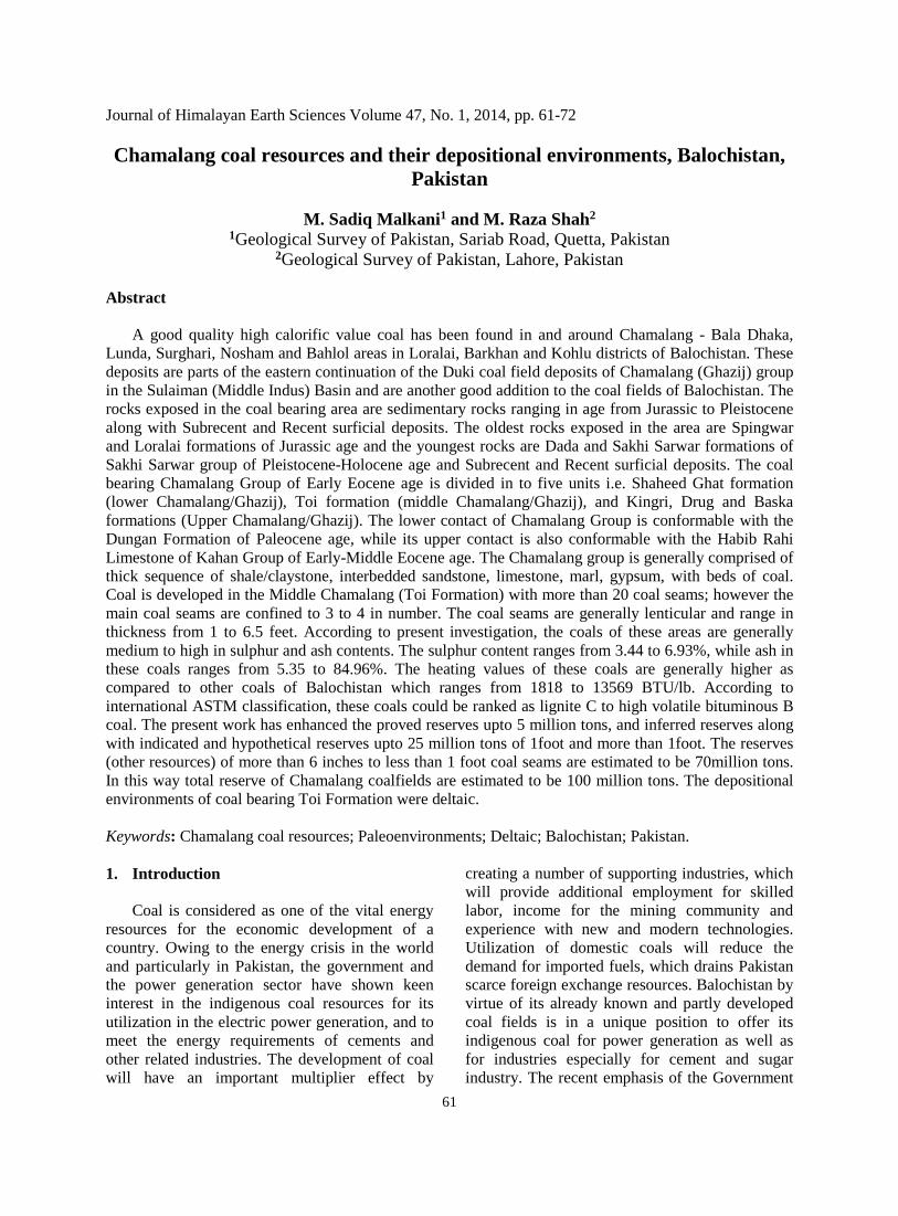
Chamalang coalfields lie in the Districts Kohlu, Barkhan, and Loralai and are covered by the topographic sheet Nos. 39 F/8 and 39 F/12 of the Survey of Pakistan (Fig. 1). It spreads over 500 sq. miles and is bounded by longitude 69015’ to 69045’east and latitude 300 00’ to 300 15’ north. The Chamalang and Bala Dhaka are the main villages of the area and are situated about 35 and 28 miles north of Kohlu respectively. The roads between these areas are partly metalled and shingled. Now the Pak Army has built a new road from Mekhtar to Chamalang, which is the main linkage and approached road for all types of communication and traveling.
Fig. 1. The black rectangle in the Index Map of Pakistan represents the Chamalang coalsfields (Survey
of Pakistan Toposheet No. 39 F/8 and 39 F/12) in Sulaiman (Middle Indus) Basin, Balochistan, Pakistan.
62
2. General geology and stratigraphy of Chamalang coalfields
Sedimentary rocks of marine and non marine
origin ranging in age from Jurassic to Pleistocene along with Subrecent and Recent surficial deposits constitute the following stratigraphic sequence (Malkani, 2010b, 2011, 2012a) of the map area. The Permo-Triassic Khanozai Group (Gawal Formation-shale with thin bedded limestone; and Wulgai Formation-shale with medium bedded limestone), Jurassic Sulaiman Group (Spingwar, Loralai and Chiltan formations; ammonite bearing limestone, marl and shale) and Early Cretaceous Parh Group (Sembar, Goru, Parh formations; belemnite bearing shale, marl and limestone) represent fine pelagic, shallow marine and deltaic environments. The Late Cretaceous emerged by a regression of sea which is represented by Mughal Kot Formation (shale and sandstone with minor limestone), Fort Munro Limestone of carbonate shallow marine, Pab Formation (mainly sandstone with subordinate shale) of muddy to sandy shelf, distal deltaic and fluviatile environments, and Vitakri Formation (red muds and white to grey sandstone) of fluvial origin (Malkani, 2006, 2007a, b). The K-T boundary (Malkani 2009a, 2010a, 2011) in the western side of central part of middle Indus basin (Sanjawi to Ziarat and their surroundings) is represented by Late Cretaceous laterite, while eastern part is terrestrial (meandering rivers sands alternated with red muds of flood plain) beds (Malkani, 2009b). At Early Paleocene the transgression of sea emerged, which deposited the Sangiali Group like carbonate shallow marine limestone and shale (fossil bearing like bivalves, nautiloids and gastropods) of Sangiali Formation, deltaic siliciclastic Rakhi Gaj Formation and coral reef deposits of Dungan Limestone. Ghazij (Chamalang) Group (Shaheed Ghat, Toi, Kingri, Drug and Baska formations) shows marine, deltaic, continental and evaporitic environments. The Shaheed Ghat formation shows mostly shallow marine and slightly distal deltaic, Toi Formation shows deltaic conditions with suitable flora source for coal (Figs. 2-4) deposition, Kingri Formation shows meandering channel and over bank flood deposits continental environment, Drug Formation shows shallow marine, and Baska Formation shows the subkha type supra tidal evaporitic environments. Kahan Group (Habib Rahi, Domanda, Pirkoh and
Drazinda formations) was deposited under marine conditions. After this the main episode of convergence of Indo-Pakistan plate with Asian plate occurred which is responsible for the folding and faulting. The Oligocene-Pliocene Vihowa group like Chitarwata, Vihowa, Litra and Chaudhwan formations, Pleistocene-Holocene Sakhi Sarwar group like Dada and Sakhi Sarwar formations are deposited by fluviatile environments and Sub recent and Recent deposits show the alluvium with minor colluviums and eolian.
Intense folding and faulting are observed in
the Chamalang-Bahlol and Baghao areas produced by convergence of Indo-Pakistan plate with the Asian plate. Many strike slip, thrust and imbricate faults are found in the area. The area consists of many alternations of synclines and anticlines generally trending N-S and NE. Starting from west, the Siah Koh/Tor Ghar anticline is located in the western and south western part of Chamalang area and represent low to moderate dips, and Early Cretaceous Sembar as core formation. The Dhadhar Koh anticline is located in the northwestern corner of Chamalang area having moderate to high dips, with Early Cretaceous Parh as core formation. After this the Anokai syncline has moderate to high dips of strata and at places overturned with Vihowa and Sakhi Sarwar groups found in the core. This is followed by Lunda anticline (Figs. 5-7) which is thrusted and faulted in the north. It is followed by Bahlol syncline (Figs. 5, 6) with eastern limb overturned (Malkani et al., 2010a). It is followed by Nosham anticline which is also faulted in the north. It is followed by Bala Dhaka-Karher (Chuchandai) syncline and then in the south the Kali Chapri anticline with low to moderate dips and in the north the Lundi Sar anticline with moderate to high dips and in the northeast corner the Mirri Wah anticline. This is followed by Baghao (Tomni) syncline which has moderate to high dips and Domanda as core formation which is mostly covered by alluvium. This syncline is followed by Chaper anticline with moderate to high dips and Drug as core formation. Nizamwali syncline is located in the eastern part and has moderate to high dips and Drug as core formation. This syncline is followed by Lohari anticline with moderate to high dips and Drug as core formation. Narwel-Ishani syncline is located in the
63
southeastern part and has moderate to high dips and Drug as core formation. Nodo anticline is located in the southeastern part and has moderate to high dips and Shaheed Ghat as core formation (Malkani et al., 2010b). Many strike slip, normal and thrust faults are found in the Chamalang
coalfields area. These faults have also disturbed the coal deposits like Anokai strike slip fault has disturbed the coal in its surrounding areas. Further the Toba Qadri, Mari Bijar, Lunda and Nosham thrust faults have also disturbed the coal in their vicinity.
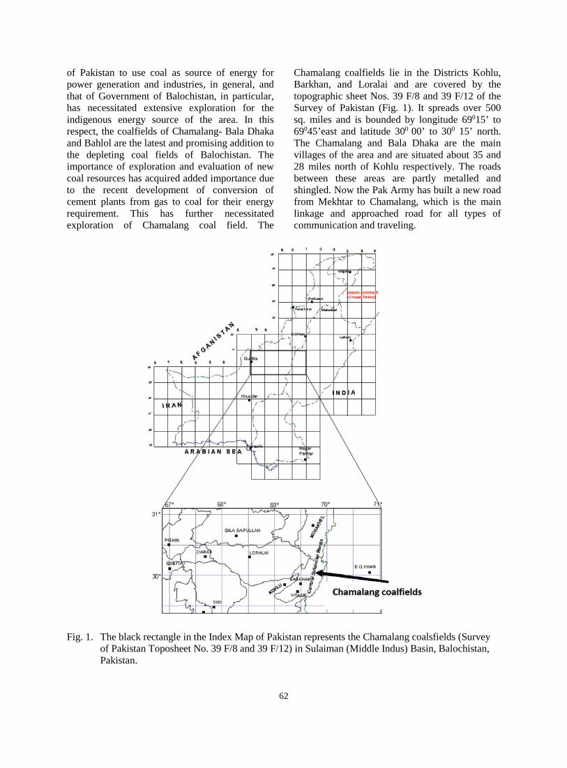
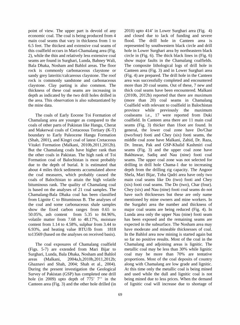
Fig. 2. Toi Formation and its coal behaviour in Mari Bijar, Canteen Yadgar and Nasir mines sections of
Chamalang Coal fields. There are maximum number and thick coal seams in Canteen Yadgar area, while +the quantity of coal seams are decreasing towards southwest (Mari Bijar) and the quantity and thickness of the seams are decreasing towards northeast (Nasir mines Lower Surgahri) (not to the scale). The location of these three sections are marked in Fig. 5.
64
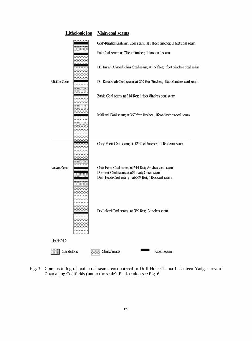
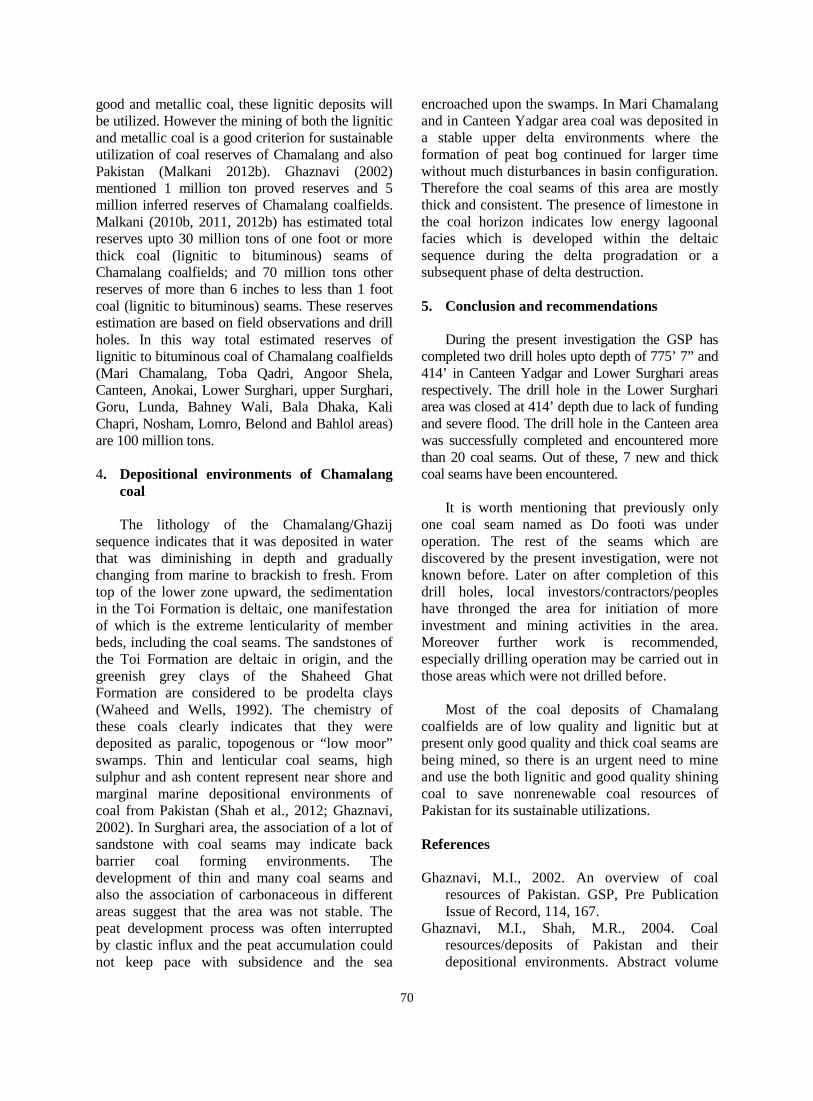
Fig. 3. Composite log of main coal seams encountered in Drill Hole Chama-1 Canteen Yadgar area of
Chamalang Coalfields (not to the scale). For location see Fig. 6.
65
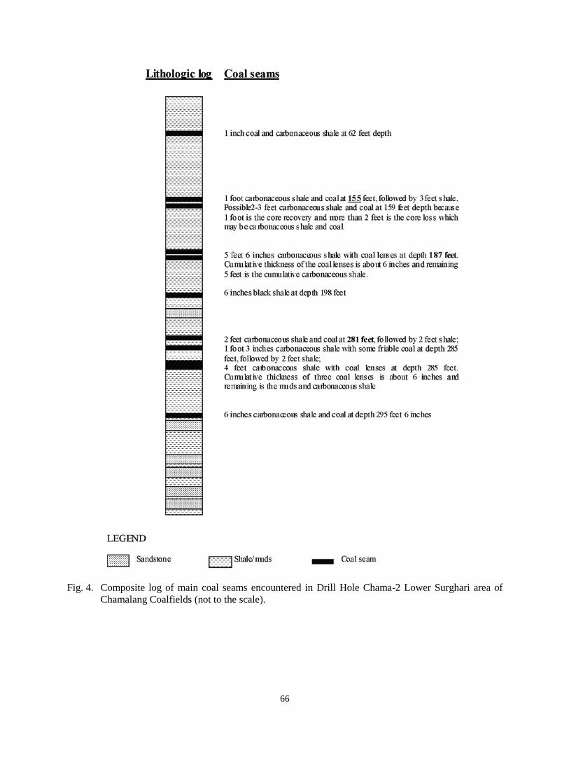
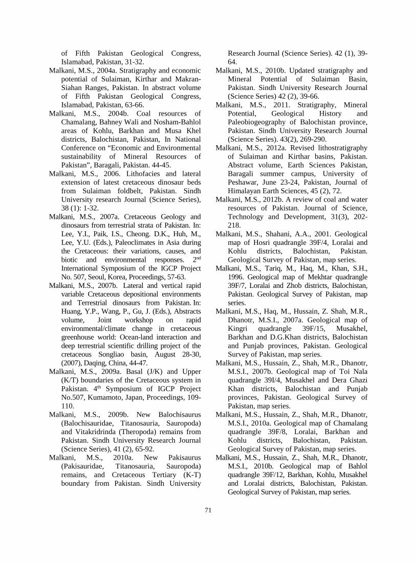
Fig. 4. Composite log of main coal seams encountered in Drill Hole Chama-2 Lower Surghari area of
Chamalang Coalfields (not to the scale).
66
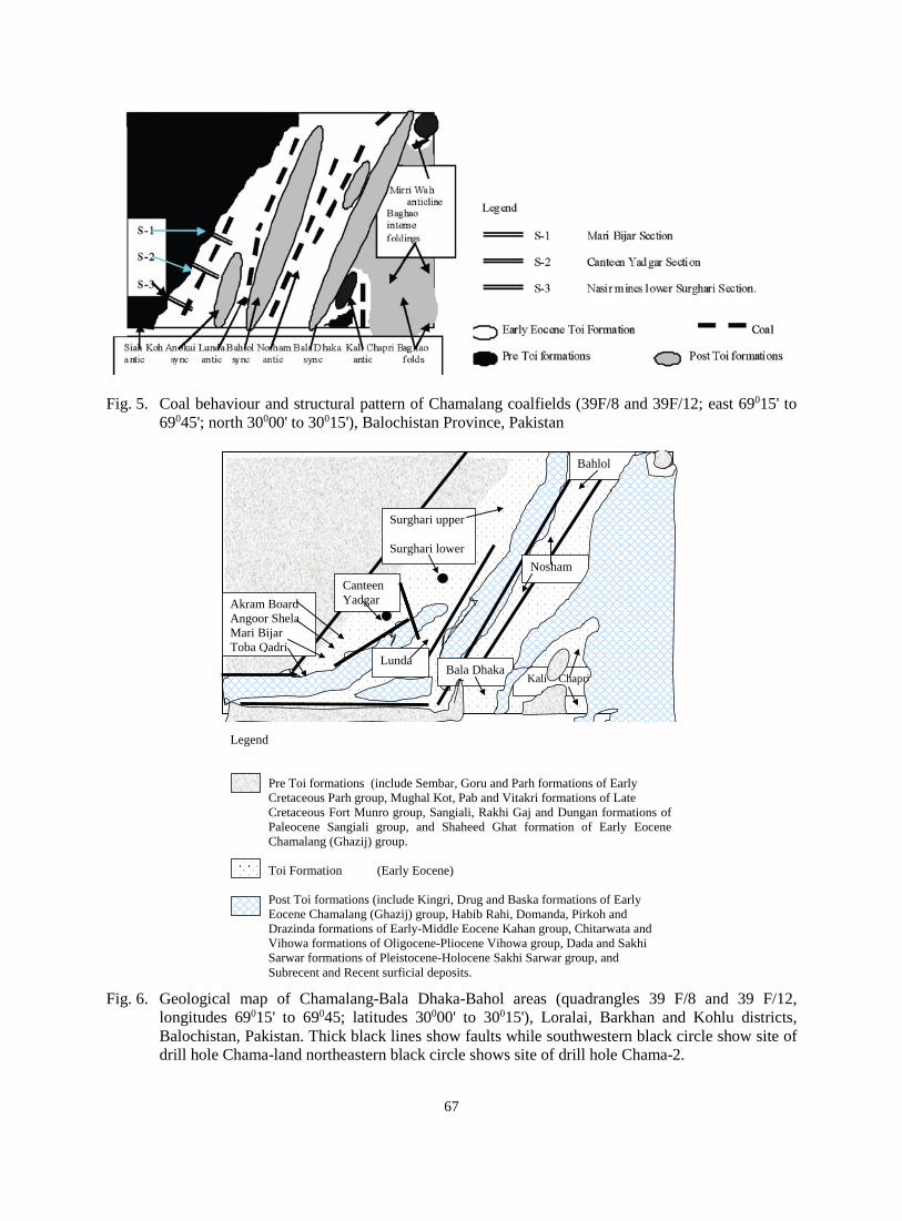
Fig. 5. Coal behaviour and structural pattern of Chamalang coalfields (39F/8 and 39F/12; east 69015' to
69045'; north 30000' to 30015'), Balochistan Province, Pakistan
Akram Board Angoor Shela Mari Bijar Toba Qadri
Surghari upper Surghari lower
Lunda
Nosham
Bahlol
Kali Chapri
Canteen Yadgar
Bala Dhaka
Legend
Pre Toi formations (include Sembar, Goru and Parh formations of Early Cretaceous Parh group, Mughal Kot, Pab and Vitakri formations of Late Cretaceous Fort Munro group, Sangiali, Rakhi Gaj and Dungan formations of Paleocene Sangiali group, and Shaheed Ghat formation of Early Eocene Chamalang (Ghazij) group.
Toi Formation (Early Eocene) Post Toi formations (include Kingri, Drug and Baska formations of Early Eocene Chamalang (Ghazij) group, Habib Rahi, Domanda, Pirkoh and Drazinda formations of Early-Middle Eocene Kahan group, Chitarwata and
Vihowa formations of Oligocene-Pliocene Vihowa group, Dada and Sakhi Sarwar formations of Pleistocene-Holocene Sakhi Sarwar group, and Subrecent and Recent surficial deposits.
Fig. 6. Geological map of Chamalang-Bala Dhaka-Bahol areas (quadrangles 39 F/8 and 39 F/12,
longitudes 69015' to 69045; latitudes 30000' to 30015'), Loralai, Barkhan and Kohlu districts, Balochistan, Pakistan. Thick black lines show faults while southwestern black circle show site of drill hole Chama-land northeastern black circle shows site of drill hole Chama-2.
67
F
F F
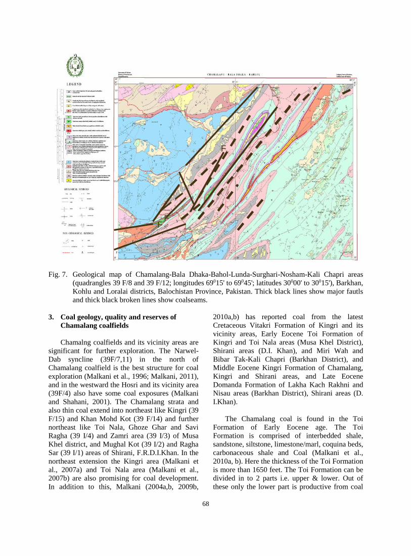
Fig. 7. Geological map of Chamalang-Bala Dhaka-Bahol-Lunda-Surghari-Nosham-Kali Chapri areas
(quadrangles 39 F/8 and 39 F/12; longitudes 69015' to 69045'; latitudes 30000' to 30015'), Barkhan, Kohlu and Loralai districts, Balochistan Province, Pakistan. Thick black lines show major fautls and thick black broken lines show coalseams.
3. Coal geology, quality and reserves of
Chamalang coalfields
Chamalng coalfields and its vicinity areas are significant for further exploration. The Narwel-Dab syncline (39F/7,11) in the north of Chamalang coalfield is the best structure for coal exploration (Malkani et al., 1996; Malkani, 2011), and in the westward the Hosri and its vicinity area (39F/4) also have some coal exposures (Malkani and Shahani, 2001). The Chamalang strata and also thin coal extend into northeast like Kingri (39 F/15) and Khan Mohd Kot (39 F/14) and further northeast like Toi Nala, Ghoze Ghar and Savi Ragha (39 I/4) and Zamri area (39 I/3) of Musa Khel district, and Mughal Kot (39 I/2) and Ragha Sar (39 I/1) areas of Shirani, F.R.D.I.Khan. In the northeast extension the Kingri area (Malkani et al., 2007a) and Toi Nala area (Malkani et al., 2007b) are also promising for coal development. In addition to this, Malkani (2004a,b, 2009b,
2010a,b) has reported coal from the latest Cretaceous Vitakri Formation of Kingri and its vicinity areas, Early Eocene Toi Formation of Kingri and Toi Nala areas (Musa Khel District), Shirani areas (D.I. Khan), and Miri Wah and Bibar Tak-Kali Chapri (Barkhan District), and Middle Eocene Kingri Formation of Chamalang, Kingri and Shirani areas, and Late Eocene Domanda Formation of Lakha Kach Rakhni and Nisau areas (Barkhan District), Shirani areas (D. I.Khan).
The Chamalang coal is found in the Toi Formation of Early Eocene age. The Toi Formation is comprised of interbedded shale, sandstone, siltstone, limestone/marl, coquina beds, carbonaceous shale and Coal (Malkani et al., 2010a, b). Here the thickness of the Toi Formation is more than 1650 feet. The Toi Formation can be divided in to 2 parts i.e. upper & lower. Out of these only the lower part is productive from coal
68
point of view. The upper part is devoid of any economic coal. The coal is being produced from 4 main coal seams that vary in thickness from 1 to 6.5 feet. The thickest and extensive coal seams of this coalfield occurs in Mari-Chamalang area (Fig. 2), while the thin and relatively less extensive coal seams are found in Surghari, Lunda, Bahney Wali, Bala Dhaka, Nosham and Bahlol areas. The floor rock is commonly carbonaceous claystone or sandy grey lateritic/calcareous claystone. The roof rock is commonly sandstone and carbonaceous claystone. Clay parting is also common. The thickness of these coal seams are increasing in depth as indicated by the two drill holes drilled in the area. This observation is also substantiated by the mine data.
The coals of Early Eocene Toi Formation of
Chamalang area are younger as compared to the coals of other parts of Pakistan like Hangu, Cherat and Makerwal coals of Cretaceous Tertiary (K-T) boundary to Early Paleocene Hangu Formation (Shah, 2001), and Kingri coal of latest Cretaceous Vitakri Formation (Malkani, 2010b,2011,2012b). But the Chamalang coals have higher rank than the other coals in Pakistan. The high rank of Toi Formation coal of Balochistan is most probably due to the depth of burial. It is estimated that about 4 miles thick sediments accumulated above the coal measures, which probably caused the coals of Balochistan to attain the high volatile bituminous rank. The quality of Chamalang coal is based on the analyses of 21 coal samples. The Chamalang-Bala Dhaka coal has been classified from Lignite C to Bituminous B. The analyses of the coal and some carbonaceous shale samples show the fixed carbon ranges from 0.65 to 50.05%, ash content from 5.35 to 84.96%, volatile matter from 7.68 to 48.17%, moisture content from 1.14 to 4.58%, sulphur from 3.44 to 6.93%, and heating value BTU/lb from 1818 to13569 (based on the analyses on received basis).
The coal exposures of Chamalang coalfield (Figs. 5-7) are extended from Mari Bijar to Surghari, Lunda, Bala Dhaka, Nosham and Bahlol areas (Malkani, 2004a,b,2010b,2011,2012b; Ghaznavi and Shah, 2004; Shah et al., 2004). During the present investigation the Geological Survey of Pakistan (GSP) has completed one drill hole (in 2009) upto depth of 775’ 7’’ in the Canteen area (Fig. 3) and the other hole drilled (in
2010) upto 414’ in Lower Surghari area (Fig. 4) and closed due to lack of funding and severe flood. The drill hole in Canteen area is represented by southwestern black circle and drill hole in Lower Surghari area by northeastern black circle in (Fig. 6). The thick black lines in (Fig. 6) show major faults in the Chamalang coalfields. The composite lithological logs of drill hole in Canteen area (Fig. 3) and in Lower Surghari area (Fig. 4) are prepared. The drill hole in the Canteen area was successfully completed and encountered more than 20 coal seams. Out of these, 7 new and thick coal seams have been encountered. Malkani (2010b, 2012b) reported that there are maximum (more than 20) coal seams in Chamalang Coalfield with relevant to coalfield in Balochistan province while previously the maximum coalseams i.e., 17 were reported from Duki coalfield. In Canteen area there are 11 main coal seams (Fig. 3) thicker than 1foot are found. In general, the lower coal zone have Do/Char (two/four) footi and Chey (six) footi seams, the middle coal zone have Malkani, Zahid, Dr. Raza, Dr. Imran, Pak and GSP-Khalid Kashmiri coal seams (Fig. 3) and the upper coal zone have Bakhtawar, Sadiq and Nau (nine) footi coal seams. The upper coal zone was not selected for drilling in drill hole Chama-1 due to increasing depth from the drilling rig capacity. The Angoor Shela, Mari Bijar, Toba Qadri area have only two main coal seams like Do (two) footi and Chey (six) footi coal seams. The Do (two), Char (four). Chey (six) and Nau (nine) footi coal seams do not have such thicknesses but these are only name mentioned by mine owners and mine workers. In the Surgahri area the number and thickness of major coal seams are being reduced (Fig. 4). In Lunda area only the upper Nau (nine) footi seam has been exposed and the remaining seams are expected in the subsurface. The Nosham area may have moderate and mineable thicknesses of coal. In the Bahlol area now mining is started again but so far no positive results. Most of the coal in the Chamalang and adjoining areas is lignitic. The metallic coal may be less than 30% while lignitic coal may be more than 70% are tentative proportions. Most of the coal deposits of country along with Chamalang are low grade and lignitic. At this time only the metallic coal is being mined and used while the dull and lignitic coal is not being mined due to less prices. When the demand of lignitic coal will increase due to shortage of
69
good and metallic coal, these lignitic deposits will be utilized. However the mining of both the lignitic and metallic coal is a good criterion for sustainable utilization of coal reserves of Chamalang and also Pakistan (Malkani 2012b). Ghaznavi (2002) mentioned 1 million ton proved reserves and 5 million inferred reserves of Chamalang coalfields. Malkani (2010b, 2011, 2012b) has estimated total reserves upto 30 million tons of one foot or more thick coal (lignitic to bituminous) seams of Chamalang coalfields; and 70 million tons other reserves of more than 6 inches to less than 1 foot coal (lignitic to bituminous) seams. These reserves estimation are based on field observations and drill holes. In this way total estimated reserves of lignitic to bituminous coal of Chamalang coalfields (Mari Chamalang, Toba Qadri, Angoor Shela, Canteen, Anokai, Lower Surghari, upper Surghari, Goru, Lunda, Bahney Wali, Bala Dhaka, Kali Chapri, Nosham, Lomro, Belond and Bahlol areas) are 100 million tons. 4. Depositional environments of Chamalang
coal
The lithology of the Chamalang/Ghazij sequence indicates that it was deposited in water that was diminishing in depth and gradually changing from marine to brackish to fresh. From top of the lower zone upward, the sedimentation in the Toi Formation is deltaic, one manifestation of which is the extreme lenticularity of member beds, including the coal seams. The sandstones of the Toi Formation are deltaic in origin, and the greenish grey clays of the Shaheed Ghat Formation are considered to be prodelta clays (Waheed and Wells, 1992). The chemistry of these coals clearly indicates that they were deposited as paralic, topogenous or “low moor” swamps. Thin and lenticular coal seams, high sulphur and ash content represent near shore and marginal marine depositional environments of coal from Pakistan (Shah et al., 2012; Ghaznavi, 2002). In Surghari area, the association of a lot of sandstone with coal seams may indicate back barrier coal forming environments. The development of thin and many coal seams and also the association of carbonaceous in different areas suggest that the area was not stable. The peat development process was often interrupted by clastic influx and the peat accumulation could not keep pace with subsidence and the sea
encroached upon the swamps. In Mari Chamalang and in Canteen Yadgar area coal was deposited in a stable upper delta environments where the formation of peat bog continued for larger time without much disturbances in basin configuration. Therefore the coal seams of this area are mostly thick and consistent. The presence of limestone in the coal horizon indicates low energy lagoonal facies which is developed within the deltaic sequence during the delta progradation or a subsequent phase of delta destruction. 5. Conclusion and recommendations
During the present investigation the GSP has completed two drill holes upto depth of 775’ 7” and 414’ in Canteen Yadgar and Lower Surghari areas respectively. The drill hole in the Lower Surghari area was closed at 414’ depth due to lack of funding and severe flood. The drill hole in the Canteen area was successfully completed and encountered more than 20 coal seams. Out of these, 7 new and thick coal seams have been encountered.
It is worth mentioning that previously only
one coal seam named as Do footi was under operation. The rest of the seams which are discovered by the present investigation, were not known before. Later on after completion of this drill holes, local investors/contractors/peoples have thronged the area for initiation of more investment and mining activities in the area. Moreover further work is recommended, especially drilling operation may be carried out in those areas which were not drilled before.
Most of the coal deposits of Chamalang
coalfields are of low quality and lignitic but at present only good quality and thick coal seams are being mined, so there is an urgent need to mine and use the both lignitic and good quality shining coal to save nonrenewable coal resources of Pakistan for its sustainable utilizations. References Ghaznavi, M.I., 2002. An overview of coal
resources of Pakistan. GSP, Pre Publication Issue of Record, 114, 167.
Ghaznavi, M.I., Shah, M.R., 2004. Coal resources/deposits of Pakistan and their depositional environments. Abstract volume
70
of Fifth Pakistan Geological Congress, Islamabad, Pakistan, 31-32.
Malkani, M.S., 2004a. Stratigraphy and economic potential of Sulaiman, Kirthar and Makran-Siahan Ranges, Pakistan. In abstract volume of Fifth Pakistan Geological Congress, Islamabad, Pakistan, 63-66.
Malkani, M.S., 2004b. Coal resources of Chamalang, Bahney Wali and Nosham-Bahlol areas of Kohlu, Barkhan and Musa Khel districts, Balochistan, Pakistan, In National Conference on “Economic and Environmental sustainability of Mineral Resources of Pakistan”, Baragali, Pakistan. 44-45.
Malkani, M.S., 2006. Lithofacies and lateral extension of latest cretaceous dinosaur beds from Sulaiman foldbelt, Pakistan. Sindh University research Journal (Science Series), 38 (1): 1-32.
Malkani, M.S., 2007a. Cretaceous Geology and dinosaurs from terrestrial strata of Pakistan. In: Lee, Y.I., Paik, I.S., Cheong. D.K., Huh, M., Lee, Y.U. (Eds.), Paleoclimates in Asia during the Cretaceous: their variations, causes, and biotic and environmental responses. 2nd International Symposium of the IGCP Project No. 507, Seoul, Korea, Proceedings, 57-63.
Malkani, M.S., 2007b. Lateral and vertical rapid variable Cretaceous depositional environments and Terrestrial dinosaurs from Pakistan. In: Huang, Y.P., Wang, P., Gu, J. (Eds.), Abstracts volume, Joint workshop on rapid environmental/climate change in cretaceous greenhouse world: Ocean-land interaction and deep terrestrial scientific drilling project of the cretaceous Songliao basin, August 28-30, (2007), Daqing, China, 44-47.
Malkani, M.S., 2009a. Basal (J/K) and Upper (K/T) boundaries of the Cretaceous system in Pakistan. 4th Symposium of IGCP Project No.507, Kumamoto, Japan, Proceedings, 109-110.
Malkani, M.S., 2009b. New Balochisaurus (Balochisauridae, Titanosauria, Sauropoda) and Vitakridrinda (Theropoda) remains from Pakistan. Sindh University Research Journal (Science Series), 41 (2), 65-92.
Malkani, M.S., 2010a. New Pakisaurus (Pakisauridae, Titanosauria, Sauropoda) remains, and Cretaceous Tertiary (K-T) boundary from Pakistan. Sindh University
Research Journal (Science Series). 42 (1), 39-64.
Malkani, M.S., 2010b. Updated stratigraphy and Mineral Potential of Sulaiman Basin, Pakistan. Sindh University Research Journal (Science Series) 42 (2), 39-66.
Malkani, M.S., 2011. Stratigraphy, Mineral Potential, Geological History and Paleobiogeography of Balochistan province, Pakistan. Sindh University Research Journal (Science Series). 43(2), 269-290.
Malkani, M.S., 2012a. Revised lithostratigraphy of Sulaiman and Kirthar basins, Pakistan. Abstract volume, Earth Sciences Pakistan, Baragali summer campus, University of Peshawar, June 23-24, Pakistan, Journal of Himalayan Earth Sciences, 45 (2), 72.
Malkani, M.S., 2012b. A review of coal and water resources of Pakistan. Journal of Science, Technology and Development, 31(3), 202-218.
Malkani, M.S., Shahani, A.A., 2001. Geological map of Hosri quadrangle 39F/4, Loralai and Kohlu districts, Balochistan, Pakistan. Geological Survey of Pakistan, map series.
Malkani, M.S., Tariq, M., Haq, M., Khan, S.H., 1996. Geological map of Mekhtar quadrangle 39F/7, Loralai and Zhob districts, Balochistan, Pakistan. Geological Survey of Pakistan, map series.
Malkani, M.S., Haq, M., Hussain, Z. Shah, M.R., Dhanotr, M.S.I., 2007a. Geological map of Kingri quadrangle 39F/15, Musakhel, Barkhan and D.G.Khan districts, Balochistan and Punjab provinces, Pakistan. Geological Survey of Pakistan, map series.
Malkani, M.S., Hussain, Z., Shah, M.R., Dhanotr, M.S.I., 2007b. Geological map of Toi Nala quadrangle 39I/4, Musakhel and Dera Ghazi Khan districts, Balochistan and Punjab provinces, Pakistan. Geological Survey of Pakistan, map series.
Malkani, M.S., Hussain, Z., Shah, M.R., Dhanotr, M.S.I., 2010a. Geological map of Chamalang quadrangle 39F/8, Loralai, Barkhan and Kohlu districts, Balochistan, Pakistan. Geological Survey of Pakistan, map series.
Malkani, M.S., Hussain, Z., Shah, M.R., Dhanotr, M.S.I., 2010b. Geological map of Bahlol quadrangle 39F/12, Barkhan, Kohlu, Musakhel and Loralai districts, Balochistan, Pakistan. Geological Survey of Pakistan, map series.
71
Shah, M.R., 2001. Paleoenvironments, sedimentology and economic aspects of the paleocene Hangu formation in Kohat-Potwar and Hazara area. Unpublished Ph.D. thesis, National Centre of Excellence in Geology, University of Peshawar, Peshawar, 208.
Shah, M.R., Malkani, M.S., Kakepoto, A.A., 2012. Coal resources of Pakistan and their depositional environments. Abstract volume and program, Earth Sciences Pakistan, Baragali Summer Campus, University of Peshawar, June 23-24, Pakistan. Journal of Himalayan Earth Sciences, 45 (2), 94-95.
Shah, M.R., Ghaznavi, M.I., Shaheed, H., Malkani, M.S., Dasti, N., 2004. Geology of coal fields of the Chamalang,-Bala Dhaka
and Bahlol areas, in Kohlu, Barkhan and Loralai districts of Balochistan. In: Hussain, S.S., and Akbar, H.D. (Eds.), Fifth Pakistan Geological Congress, 14-15 April, Islamabad, National Geological Society of Pakistan, Pakistan Museum of Natural History (Pakistan Science Foundation), Islamabad. 33A-34A.
Waheed, A., Wells, N.A., 1992. Changes in paleocurrents during the development of an obliquely convergence plate boundary, Sulaiman foldbelt, southwestern Himalaya, west central Pakistan. Sedimentary Geology, 67, 237-261.
72