chapter 06 - national interagency fire center · web viewinclude such information as taxiway...
TRANSCRIPT

CHAPTER 6Temporary Flight Restrictions
and Advisory NOTAMSI. Introduction
In order to enhance safety during an incident or project, the FAA may be requested to issue a Notification to Airmen (NOTAM) to pilots; these could be either a Temporary Flight Restriction (TFR) or a NOTAM (L) or NOTAM (D). In addition to the NOTAM process, agency personnel contact military facilities and or other agency aviation units to request deconfliction of the involved airspace.
Deconfliction is a process that involves the separation of land management agency and other types of aircraft that may pose a flight hazard. This process is frequently used by local dispatch to inform military units of activity whether emergency or planned. This deconfliction is negotiable unless a TFR is involved. Local dispatch may also use deconfliction information to notify other agency aircraft of an evolving situation that requires deconfliction for safety. See Chapter 7 for additional Airspace Deconfliction information.
A TFR applies to an area of airspace (defined both laterally and vertically) that has been temporarily or partially closed to non-participatory aircraft for a specified period of time. Flight restrictions may be requested in response to the aviation safety need for separation of aircraft for disaster or incident activities.
This chapter describes the types of conditions under which the FAA may impose temporary flight restrictions. It also explains the FAA authority to issue a TFR NOTAM and lists the types of responsible agencies/offices from which the FAA will accept requests to establish TFRs.
The Code of Federal Regulations (14 CFR) is explicit as to what operations are prohibited, restricted or allowed in a temporary flight restriction area. Pilots are responsible to comply with 14 CFR sections 91.137, 91.138, 91.141, 91.143, 91.144, 91.145 and 99.7 when conducting a flight in an area where a TFR is in effect, and should check appropriate NOTAMs during flight planning.

II. Notices to Airmen (NOTAMs)
NOTAMs are one of the FAA’s methods of distributing information to pilots. When changes occur so rapidly that time does not permit issuance on a chart or in an appropriate publication, they are published as NOTAMs. They may contain information (recent changes or not publicized elsewhere) concerning the establishment, condition of, or change in, any component (facility, service, procedure or hazard) of the National Airspace System. NOTAMs may be regulatory (restrictive) or advisory (informational) in nature. NOTAM information is classified into six categories: NOTAM(D), NOTAM(L), Class II NOTAMs, FDC NOTAMs, Pointer NOTAMs and Military NOTAMs. Many NOTAMs are abbreviated. The NOTAM approved contractions are listed in Appendix 5 of the FAA Order Notices to Airmen 7930.2H located at http://ww2.faa.gov/atpubs.
A. Advisory NOTAMs
1. NOTAM (D)
NOTAM (D) information is advisory in nature and is not restrictive. The “D” pertains to the kind of dissemination method used by the FAA; in this case it would be a “wide” dissemination. A NOTAM (D) advertises changes to the NAS that would clause a pilot to rearrange or reconsider the flight. They pertain to enroute navigation aids, civil public use landing areas listed in the Airport/Facility Directory (AFD) and aeronautical data that are related to Instrument Flight Rules (IFR) operations. They are disseminated to all navigational facilities within the NAS, and all public use airports, seaplane bases and heliports listed in the Airport/Facility Directory.
Example NOTAM(D) Situations:
NAVAID outages and restrictions Airport closures and commissioning Runway restrictions Communications Changes in ATC service
2. NOTAM (L)
NOTAM (L) information is advisory in nature and is not restrictive. The “L” pertains to the kind of dissemination method used by the FAA; in this case it would be “local” dissemination. A NOTAM (L) may

include such information as taxiway closures, personnel or equipment near or crossing runways, airport rotating beacon outages and airport lighting aids. NOTAM (L) information is not attached to the hourly weather reports. A separate file of local NOTAMs is maintained at each Flight Service Station (FSS) for facilities in their area. NOTAM (L) information for other FSS areas must be specifically requested directly from the applicable FSS.
Example NOTAM(L) Situations:
Conditions affecting taxiways Non-essential lighting Short (usually less than one hour) service outages Deer on the runway
In some cases a NOTAM (L) or NOTAM (D) may be appropriate. Judg-ment should be used in determining the need. Often a FSS will institute a NOTAM(L) while waiting to receive a TFR from the NFDC. There are projects or incidents that do not meet TFR criteria, but need FSS assistance in dissemination to non-participating aircraft. For ex-ample, there may be no need to close or restrict the involved airspace, but it is prudent to notify general aviation or military aircraft of a potential conflict or traffic. Items that fit this definition may include prescribed burns, blasting, training exercises, resource projects or obstructions.
a. Ordering Procedures for an Advisory NOTAM (NOTAM (L) or NOTAM (D))
The dispatcher or aviation manager should submit the request to the FSS. A TFR Request Form may be used for this purpose, but should be clearly marked NOTAM(L) or Advisory request. Copy to the GACC if appropriate.
Furnish the information to the FSS and, as appropriate, to the military, via phone. It is also strongly recommended that copies be faxed to offices involved. A hard copy often clarifies any information relayed verbally. If faxed, requests must be followed up by verbal confirmation.
The FSS will issue an Advisory NOTAM. When a NOTAM (L) is required, this is usually processed immediately.
FIGURE 6-1 Actual NOTAM Examples
Actual NOTAM Examples (NOT FOR NAVIGATIONAL PURPOSES):
NOTAM(D)s raw: !OGD 04/003 OGD 3/21 CLSD WEF 0304141400-0311302359
translated: Ogden UT (Ogden-Hinckley) [OGD]: April NOTAM #3 3/21 closed will be effective April 14th, 2003 at 08:00 AM MDT (0304141400) November 30th, 2003 at 05:59 PM MDT (0311302359)
raw: !SJC 05/003 SJC TOWER 146 (80 AGL) .82 SE LGTS OTS TIL 0305142350
translated: San Jose CA (Norman Y. Mineta San Jose International) [SJC]: May NOTAM #3 Tower 146 (80 above ground level). 82 southeast lights out of service until May 14th, 2003 at 04:50 PM MDT (0305142350)
NOTAM-L’s:
raw: PUC 18 RUN UP AREA CLOSED
translated: Price (Carbon County) Airport Runway 18 run-up area closed.
raw: VEL 25 REIL OTS
translated: Vernal (Uintah County) Airport runway 25 runway end identifier lights out of service
Pointer NOTAM:
raw: ! ACT 12/045 ACT SEE FDC 02/8989 ZFW 91.141 points users to read FDC NOTAM 2.8989

Modifications and cancellations of an Advisory NOTAM require coordination with the affected FSS, GACC, and military units. When changes are approved, FSS will issue a corrected Advisory NOTAM.
Cancel the Advisory NOTAM by contacting the FSS. Docu-ment and close out agency paperwork as appropriate.
3. Pointer NOTAMs
Issued by a flight service station to highlight or point out another NOTAM; such as FDC NOTAMs. This type of NOTAM will assist users in cross-referencing important information that may not be found under an airport or NAVAID identifier. For example, a Flight Service Station might issue a pointer NOTAM for a TFR in it’s area.
4. Military NOTAMs
NOTAMs pertaining to U.S. Air Force, Army, Marine, and Navy naviga-tional aids/airports that are part of the NAS.
5. Class II (Published) NOTAMs
NOTAMs which are known sufficiently in advance, and are expected to remain in effect for some time, are published every four weeks, which is available through subscription at the Government Printing Office or on the internet at www.faa.gov.
6. FDC NOTAM
FDC NOTAM information is regulatory and is often restrictive. On those occasions when it becomes necessary to disseminate regulatory information, the National Flight Data Center (NFDC) in Washington, D.C. will issue FDC NOTAMs. These are legal regulations, but may also contain information such as amendments to published Instrument Approach Procedures (IAPs) , Sectional Charts and the National Airspace System. The US NOTAM Office transmits them to the appropriate FSS and ARTCCs. Note that the FDC NOTAM may be a TFR or other information such as a laser show location.
Intrusions into a TFR without proper authorization can lead to an enforcement action. Post 9/11 security TFR intrusions can lead to interception, force down or a “shoot down” by military aircraft.

III. Nine Types of TFRs
There are nine kinds of TFRs. Three are issued under 14 CFR 91.137 sub-para-graphs (a)(1), (a)(2) and (a)(3). The rest are under 14 CFR 91.138, 91.141, 91.143, 91.144, 91.145 and 99.7. The type of TFR established varies according to the need.
A. 14 CFR 91.137(a)(1) TFR in the Vicinity of Disaster/Hazard Areas
The intent of TFRs issued under this paragraph is to protect persons and property on the surface or in the air from an existing or imminent hazard associated with an incident on the surface, when the presence of low flying aircraft would magnify, alter, spread or compound that hazard. This is the most restrictive of TFRs and is rarely issued for wildland fire incidents. It is more commonly used for the following:
Toxic gas leaks, spills or fumes from flammable agents Volcanic eruptions Nuclear accidents or incidents Hijacking incidents Aircraft accident sites (at the discretion of the FAA)
No person may operate an aircraft within the TFR unless that aircraft is participating in the hazard relief activities and is being operated under the direction of the official in charge of on scene emergency response activities.
91.137(a)(1) TFRs may be recommended or requested by military major command headquarters, regional directors of the Office of Emergency Planning, Civil Defense State Directors, State Governors or other similar authority.
Example of a 91.137 (a) 1 TFR (NOTFORNAVIGATIONALPURPOSES)
2/9559 - CO.. FLIGHT RESTRICTIONS PUEBLO, CO EFFECTIVE IMMEDIATELY UNTIL FURTHER NOTICE. PURSUANT TO TITLE 14 CFR SECTION 91.137A(1) TEMPORARY FLIGHT RESTRICTIONS ARE IN EFFECT DUE TO NATIONAL SECURITY ARE NOT AUTHORIZED WITHIN A 3 NAUTICAL MILES RADIUS OF 381840N/1042051W OR THE PUEBLO /PUB/ VORTAC 063 DEGREE RADIAL AT 04 NAUTICAL MILES AT AND BELOW 3000 FEET AGL TO PROVIDE FOR A SAFE ENVIRONMENT FOR DOD OPERATIONS. DENVER AFSS /DEN/ 720-873-XXXX IS THE FAA COORDINATION FACILITY. NOTE: UNLESS AUTHORIZED BY ATC FOR PURPOSES OF CONDUCTING ARRIVAL/DEPARTURE OPERATIONS. WIE UNTIL UFN

B. 14 CFR 91.137(a)(3)
The intent of TFRs issued under this section is to prevent unsafe congestion of sightseeing aircraft above an incident or event that generates a high degree of public interest. This type of TFR has been granted in the past for activities such as spray projects, wild horse round ups and prescribed burns, but rarely issued post 9/11.
TFR’s may be recommended or requested under this FAR by any of those listed above or by State, county or city government entities. ATFR under the conditions of 91.137 (a)(3) will be issued by the direction of the Regional Air Traffic Division Manager having oversight of the airspace concerned.
Under this type of TFR entry for non-participating aircraft is similar to 91.137 (a)(2). Participating aircraft may be carrying incident, event or law enforce-ment officials.
1. Airport Traffic
An airport is not closed by a TFR. Operations are allowed if they are conducted directly to or from an airport within the area, if VFR flight above or around the area is impractical due to weather or terrain conditions, and if the flight is not conducted for the purpose of observing the incident or event.
2. IFR Traffic
Aircraft operating under an ATC approved IFR flight plan are allowed into the TFR.
3. Incident, Event or Law Enforcement
Aircraft are allowed inside the TFR if they are carrying incident, event or law enforcement personnel. Note that no parameters are set requiring prior notification.
4. Media
Media are allowed inside this type of TFR if the aircraft is carrying properly accredited news representatives and a flight plan is filed with the appropriate FSS or ATC facility specified in the NOTAM prior to entering the area.

C. 14 CFR Section 91.138 TFR in National Disaster Areas in the State of Hawaii
The intent of TFRs issued under this section is, for humanitarian reasons, to protect persons or property on the surface within declared national disaster areas in the State of Hawaii.
D. 14 CFR Section 91.141 Flight Restrictions in the Proximity of the President and Other Parties
The intent of TFRs issued under this section is to protect the President, Vice President or other public figures. It is sometimes put into effect during Presi-dential or other public figure’s appearance at large wildland fires. Consider-able coordination is required if fire suppression aviation activity is to con-tinue during the visit.
Example of a 91.141 TFR (NOTFORNAVIGATIONALPURPOSES)
3/3310 - MD.. FLIGHT RESTRICTIONS HAGERSTOWN/THURMONT, MD. MAY 131, 2003 LOCAL. PURSUANT TO TITLE 14, SECTION 91.141 OF THE CODE OF FEDERAL REGULATIONS, AIRCRAFT FLIGHT OPERATIONS ARE PROHIBITED WITHIN THE FOLLOWING AREA UNLESS OTHERWISE AUTHORIZED BY ATC. NOTE: MILITARY AIRCRAFT PARTICIPATING IN THE P-40 FIGHTER CAP AND WASHINGTON DULLES (IAD) ARRIVALS ON OR SOUTH OF THE MRB 065R ARE EXEMPT FROM THIS RESTRICTION. 5.0 NMR AT OR BLW 12500 FEET MSL OF 393853N/0772800W OR THE FDK351014.8 FROM 0305011010 UTC (0610 LOCAL 05/01/03) UNTIL 0306010359 UTC (2359 LOCAL 05/31/03). WIE UNTIL UFN
E. 14 CFR Section 91.143 Flight Limitations in the Proximity of Space Flight Operations
The intent of TFRs issued under this section is to provide a safe environment for space agency operations. It is frequently used in Florida, California and New Mexico.
F. 14 CFR Section 91.144 Temporary Restriction on Flight Operations During Abnormally High Barometric Pressure Conditions
The intent for TFRs issued under this section is to protect flight during abnormally high barometric pressure conditions that exceed or will exceed 31 inches of mercury.
G. 14 CFR Section 91.145 Management of Aircraft Operations in the Vicinity of Aerial Demonstrations and Major Sporting Events
The intent for TFRs issued under this section is to protect persons or prop-erty on the surface or in the air, to maintain air safety and efficiency, or to prevent the unsafe congestion of aircraft in the vicinity of an aerial demon-stration or major sporting event. Events may include Air Shows involving the Blue Angels, Thunderbirds, Golden Nights, Olympics, Rosebowl, the India-napolis 500 Race, Baseball’s All Star Game, etc.
Example of a 91.145 TFR (NOTFORNAVIGATIONALPURPOSES)
3/3736 - NC.. FLIGHT RESTRICTIONS POPE AFB, NC. DUE TO AERIAL DEMON-STRATIONS BY THE U.S. AIR FORCE THUNDERBIRDS AND OTHER DEMON-STRATION TEAMS. EFFECTIVE 0305222000 UTC (MAY 22 AT 1600 LOCAL) UNTIL 0305222130 UTC (MAY 22 AT 1730 LOCAL), 0305231800 UTC (MAY 23 AT 1400 LOCAL) UNTIL 0305232130 UTC (MAY 23 AT 1730 LOCAL), 0305241500 UTC (MAY 24 AT 1100 LOCAL) UNTIL 0305242230 UTC (MAY 24 AT 1830 LOCAL), AND 0305251500 UTC (MAY 25 AT 1100 LOCAL) UNTIL 0305252230 UTC (MAY 25 AT 1830 LOCAL). PURSUANT TO 14 CFR SECTION 91.145, MANAGEMENT OF AIRCRAFT OPERATIONS IN THE VICINITY OF AERIAL DEMONSTRATIONS AND MAJOR SPORTING EVENTS, AIRCRAFT FLIGHT OPERATIONS ARE PROHIBITED WITHIN A 5 NAUTICAL MILE RADIUS OF 351015N/0790052W FAYETTEVILLE (FAY) VOR/DME 328 DEGREE RADIAL AT 13 NAUTICAL MILES AT AND BELOW 15000 FEET AGL UNLESS AUTHORIZED BY ATC. CRAIG JUDD 910-394-xxxx IS THE POINT OF CONTACT. RALEIGH /RDU/ AFSS 919-840-xxxx IS THE FAA COORDINATION FACILITY. WIE UNTIL UFN

H. 14 CFR Section 99.7 Special Security Instructions
After the September 11th tragedies, TFRs have been issued by the FAA citing 14 CFR 99.7 Special Security Instructions, which states “each person operating an aircraft in an ADIZ or Defense Area shall, in addition to the applicable rules of this part, comply with special security instructions issued by the administration in the interest of national security and that are consis-tent with agreements between the FAA and the DoD.”
Example of a 99.7 TFR (NOTFORNAVIGATIONALPURPOSES)
3/1655 - ...SPECIAL NOTICE... FLIGHT RESTRICTIONS. EFFECTIVE IMMEDIATELY UNTIL FURTHER NOTICE, PURSUANT TO 14 CFR SECTION 99.7, SPECIAL SECURITY INSTRUCTIONS, PILOTS CONDUCTING FLIGHT OPERATIONS WITHIN THE TERRITORIAL AIRSPACE OF THE U.S. ARE ADVISED TO AVOID THE AIRSPACE ABOVE OR IN PROXIMITY TO ALL NUCLEAR POWER PLANTS. PILOTS SHOULD NOT CIRCLE OR LOITER IN THE VICINITY OF SUCH FACILITIES. PILOTS WHO DO SO CAN EXPECT TO BE INTERVIEWED BY LAW ENFORCEMENT PERSONNEL AT THEIR DESTINATION AIRPORT AND THE PILOT’S NAME MAY BE ADDED TO THE TRANSPORTATION SECURITY ADMINISTRATION (TSA) INCIDENT REPORTING SYSTEM. WIE UNTIL UFN
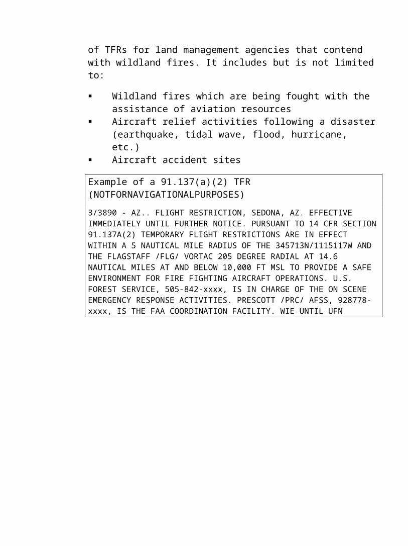
I. 14 CFR 91.137(a)(2) TFR in the Vicinity of Disaster/Hazard Areas
The intent of TFRs issued under this paragraph is to provide a safe environ-ment for the operation of disaster relief aircraft. This is the most common of TFRs for land management agencies that contend with wildland fires. It includes but is not limited to:
Wildland fires which are being fought with the assistance of aviation resources
Aircraft relief activities following a disaster (earthquake, tidal wave, flood, hurricane, etc.)
Aircraft accident sites
Example of a 91.137(a)(2) TFR (NOTFORNAVIGATIONALPURPOSES)
3/3890 - AZ.. FLIGHT RESTRICTION, SEDONA, AZ. EFFECTIVE IMMEDIATELY UNTIL FURTHER NOTICE. PURSUANT TO 14 CFR SECTION 91.137A(2) TEMPORARY FLIGHT RESTRICTIONS ARE IN EFFECT WITHIN A 5 NAUTICAL MILE RADIUS OF THE 345713N/1115117W AND THE FLAGSTAFF /FLG/ VORTAC 205 DEGREE RADIAL AT 14.6 NAUTICAL MILES AT AND BELOW 10,000 FT MSL TO PROVIDE A SAFE ENVIRONMENT FOR FIRE FIGHTING AIRCRAFT OPERATIONS. U.S. FOREST SERVICE, 505-842-xxxx, IS IN CHARGE OF THE ON SCENE EMERGENCY RESPONSE ACTIVITIES. PRESCOTT /PRC/ AFSS, 928778-xxxx, IS THE FAA COORDINATION FACILITY. WIE UNTIL UFN

TFR’s may be recommended or requested under this regulation by:
Military commanders serving as regional or area search and rescue coordinators.
Military commanders directing or coordinating air operations associ-ated with disaster relief.
Civil authorities directing or coordinating organized relief air opera-tions. This includes representatives of the Federal Emergency Man-agement Agency, US Forest Service, Bureau of Land Management, other Department of the Interior agencies and State aeronautical agencies.
The authority for agency personnel to request a TFR for land management activity or emergencies is found in 91.137 (a)(2). TFRs are normally ordered through the dispatch ordering process or channels. Dispatchers maintain the request on an aircraft resource order form that allows the TFR to be tracked, documented and closed.
91.137 (a)(2) is the TFR most commonly used for disaster relief incidents. It is important that disaster relief officials understand that certain aircraft ARE ALLOWED INSIDE THE TFR that may not be participating aircraft in the disaster relief. The following five categories of aircraft are allowed entry into a 91.137 (a)(2) TFR:
1. Participating Aircraft
Aircraft participating in hazard relief activities and are being operated under the direction of the official in charge of the on scene emergency response activity. These may include helicopters, air tankers, air attack and lead planes, smokejumper and infrared aircraft.
The following agency aircraft may not be assigned to the incident and may be considered intruders. Entry may be requested by following agency procedures. Transiting air tankers or other agency aircraft enroute to a
different fire Released aircraft transiting from one fire to another Agency VIP flights that have not been prearranged with
dispatch and air operations Recon, spray, resource, pest or mapping aircraft on normal
agency business 2. Law Enforcement

Under this type of TFR, law enforcement officials are allowed into the TFR area. There is no caveat that requires prior notification or communication during their flight. Agency personnel are strongly recommended to coordinate frequency sharing and TFR information with local law enforcement agencies that may utilize aircraft.
3. IFR Traffic
The FAA has the right to route aircraft operating under ATC approved IFR flight plans through this kind of TFR. This may occur if the TFR is located inside the approach and departure airspace for an airport.
4. Airport Traffic
TFRs do not close airports. When an airport is within or adjacent to this kind of TFR, VFR traffic is still allowed inside the TFR if the flight operation is conducted directly to or from that airport, or if VFR flight above or around the area is impractical due to weather or terrain conditions.
Notification is given to the FSS or ATC facility that is specified in the TFR. The TFR states that flight operations should not hamper or endanger relief activities, and that flights in or out of the airport should not be conducted for the purpose of observing the disaster.
An “airport” refers any airport charted on a sectional. A seaplane base must be charted and have clearly defined seaplane lanes identified at its location.
When a large TFR is established, it has been known for non-participating aircraft to legally fly from one airport to another inside the TFR. Disaster relief aviation operations in the vicinity of an airport require careful coordination and a heightened awareness of See and Avoid.
5. Media

Media access to this type of TFR may be the most misunderstood aspect of aircraft allowed into a TFR. According to 91.137 (a)(2), the following circumstances apply to media entry:
The aircraft is carrying properly accredited news representa-tives.
Prior to entering the TFR, a flight plan is filed by the media aircraft with the appropriate FAA or ATC facility specified in the TFR NOTAM.
The operation is conducted above the altitude used by the disaster relief aircraft, unless otherwise authorized by the official in charge of on-scene emergency response activities (i.e. the Air Tactical Group Supervisor).
This last item has caused the most discussion and inconsistencies in procedure. The FAA interpretation is that media aircraft are allowed inside a TFR as long as they maintain an altitude above disas FIGURE 6-4 Depiction of Media Entry into TFR ter relief aircraft. If the disaster relief aircraft happen to be on the ground, then the mediahas been known to fly at any altitude within the TFR.
No parameters are set that require communication by the media with either dispatch or the disaster relief officials in charge prior to flight. Air Tactical Group Supervisors are reminded that if the media have met the above criteria, they are allowed inside the TFR area. Air Tactical Group Supervisors have the right to allow the media to fly at lower altitudes when it can be safety accomplished, but do not have the authority to remove the media from the TFR if they have met the criteria stated in 91.137(a)(2).
Agency personnel are strongly recommended to hold pre-season meetings with local media that use aviation resources. Meetings should cover frequencies, TFR procedures, dispatch contact numbers, basic Incident Command System structure, local hazards and any other local concerns.
K. Agency TFR Requests
Agency TFR requests are usually identified by one of two means:
1. Field Generated Need
A TFR or advisory NOTAM request may be submitted to the local unit dispatch office, GACC or aviation manager by the incident commander or project manager (or an authorized representative such as the Air Tactical Group Supervisor or other on-scene personnel).
2. Dispatch or Aviation Manager Generated Need
A TFR or advisory NOTAM request may be identified by the unit dispatcher or aviation manager.
FIGURE 6-5 Ten Criteria for Determining the Need for a TFR
TEN CRITERIA FOR DETERMINING THE NEED FOR A TFR
TFRs should not be an automatic response for every dispatch involving aircraft. Con-siderable thought should go into to the determination of need for a TFR. A risk as-sessment should be done that takes into account the following criteria:
Type and number of aircraft operations (air tactical, air tanker, helicopter, smoke jumper, etc) occurring within the incident and their aeronautical requirements (orbit dimensions, both vertically and horizontally).
Entry and exit points and routes for disaster relief aircraft. Multiple incidents in close proximity. When the extent and complexity of the operation creates a hazard to
nonparticipating aircraft. Extended operations (3+ hours) are anticipated. Operations are in the vicinity of high-density aircraft traffic. Incident is expected to attract sightseeing aircraft. Operations are conducted near or in the dimensions of a MTR, VFR Helicopter
Aerial Refueling routes, Slow Routes, or SUA. Incident is conducted in or near a Victor Flyway. “See and Avoid” capability is reduced or compromised.

FIGURE 6-6 Anatomy of a TFR NOTAM
3/5174 -OR. . . Flight Restrictions Detroit, OR. Effective immediately until further notice. Pursuant to 14 CFR 91.137 (A) (2), Temporary Flight Restrictions are in effect within a 5 nautical mile radius of 435843N/1234850W and the Eugene (EUG) Vortac 236 degrees radial at 027 nautical miles at and below 5000 FT MSL to provide a safe environment for fire fighting aircraft operations. The U.S. Forest Service, Phone 503-945-xxxx/Freq xxx.xxx (Sulpher Incident) is in charge of on scene emergency Response activities. McMinnville /MMV/ AFSS, Phone 503-474-xxxx is the FAA coordination Facility. WIE until UFN.
IV. Dimensions Of A TFR
A. Standard Dimensions
The guidance for a TFR is 5 nm radius and 2000’ above the highest point or 2,000’ above the highest operating aircraft on the incident. However, each incident needs to tailor a TFR to fit their needs if a standard TFR is not appropriate.
The standard dimensions for requesting a TFR are as follows:
1. Lateral Dimension
Defined as that airspace extending five (5) nautical miles from the center point of the area affected by the disaster. Lateral dimensions can be adjusted for larger incidents; adjust for the least amount deemed necessary. See Figure 6-5.
2. Vertical Dimension–Altitude
Defined as that airspace extending up to an elevation of 2,000 feet above the highest terrain of the disaster area or above the operating altitude of participating aircraft within the lateral dimension. See Figure 6-6.
Sizes and shapes may vary due to the nature of the incident. The most frequently requested shape is circular with a center point identified. It is possible to request a non- circular shape from the FAA if the TFR
risk assessment shows that it is necessary for the safety of involved aircraft. Keep the shape simple in order to assist in the distribution of the NOTAM to pilots. Latitude and longitude points and VOR/ DME will be required for the anchor points of the non-circular TFR.
The altitude of the TFR ceiling is given to the FAA in relation to mean sea level (MSL). The NOTAM will be issued by the FAA as MSL so that the reference to ceiling height is uniform. Altitude described in terms of distance above ground level (AGL) is unacceptable, as it compromises the safety of aircraft operations. It does not take into account terrain changes, differences in flight altitudes of various aircraft on the incident, or the presence of smoke and its impact on visibility.
Rarely, the FAA may not grant the dimensions of the TFR requested by the agency. If the size specified is denied, contact the agency, State or Regional Aviation Manager or Airspace Coordinator immediately. Relay issues to the appropriate agency and incident personnel and ask the FAA to help mitigate the size and shape of the TFR.

B. Factors Which May Affect the Size and Shape of the TFR
It is recommended that initially the standard TFR (5 nautical mile (NM) radius, 2000' above highest terrain) be established. However, there are a number of factors to take into account when determining the size of a TFR, including our responsibility not to affect more airspace than necessary. TFRs may be smaller or larger than the suggested standard or they may be non-circular. The following are factors that may affect the size and shape of the TFR:
1. Type and number of aircraft operating within the incident and their orbiting and maneuvering requirements.
2. Aircraft entry and exit points and routes.
3. General aviation, military, VFR airways, airports or other aircraft operations in the geographic area.
4. Size and rate of spread of the incident.
5. Locations of incident supporting resources. Helibases, staging areas, dip sites, retardant bases.
6. MTR, SUA, Slow Routes, Aerial Refueling Routes within or near the TFR area.
7. Multiple incidents in close proximity should use a combined TFR to reduce the impact on the NAS. Do not overlap TFR’s on top of each other. Coordinate with other agencies if appropriate.
8. There are situations in which a standard circular horizontal dimension might be altered. For example, Terrain features such as a ridge line where the airspace on the side of the ridge opposite the incident does not need to be restricted; this should be considered especially when MTRs are involved.
9. The location of a helibase outside a TFR is a consideration for the size and shape of a TFR. The TFR is designed for placement over a specific disaster area and frequently a helibase could be many miles away from the actual disaster. In this case, the FAA has recommended placing a NOTAM (L) or a NOTAM (D) over the helibase and advise pilots to remember to practice “See and Avoid”. If there are SUA or MTRs between the helibase and the incident, notify the military about the TFR and helibase and request voluntary deconfliction for the airspace not inside the TFR.

V. Ordering Procedures for TFR
After the need has been identified, recommended processes for requesting a TFR and notifying military units and local personnel are described below.
Follow procedures as established by your agency. General guidelines for a risk assessment are contained in this chapter. Generally a dispatcher or aviation manager (at the GACC or unit level) should submit the request to the ARTCC.
The TFR Request Form (Figure 6-15) and Check List (Figure 6-14) are normally used to document and submit this information. Complete information is necessary for documentation and meeting the FAAs needs. The TFR request is documented and maintained on agency records such as a Resource Order form. The TFR Request Form is normally attached to the Resource Order with all other documentation. The TFR Request Form is also located in the National Mobilization Guide in Chapter 20.
Ensure that the following information has been completed:
Resource Order and Aircraft Request Number Requesting person’s name and phone number VOR, bearing/distance and matching latitude/longitude information VHF-AM air-to-air contact frequency Radius in nautical miles(NM) Highest base altitude and TFR ceiling altitude
A. Setting Up the TFR
1. Plot the center point of the TFR using the latitude and longitude on a sectional. Ensure the bearing and distance from the nearest VOR on the TFR request matches the point plotted using latitude and longitude on the sectional. Confirm latitude and longitude if using a computer-aided program such as IAMs.
The US NOTAM office will only accept TFR requests in a Degrees, Minutes, Seconds format. An internal memo within the FAA states the following:
“Effective immediately insure that all NOTAMs containing latitude and longitude information utilize Degrees, Minutes, Seconds and includes a reference to North latitude (N) and West longitude (W). If seconds are not available, add two zeros for the second spaces. Do not include spaces, commas, dashes or any other symbols. The standardized format shall be: ddmmssN/dddmmssW.”

2. Review the TFR and draw it on the sectional using the radius ex-pressed in nautical miles. Check for airports, Class B or Class C airspace, Class D, MTRs, SUA inside the proposed TFR.
3. Telephone Number Use a 24-hour contact number (not a toll-free number) that will
be in service after the incident has concluded. This number will also be the point of contact for other agencies, media, etc., regarding the TFR.
Do NOT use an expanded dispatch or a daytime-only phone number.
Do NOT use internal three or four letter codes on the TFR Request Form (Requesting Unit, etc.) as the FAA does not know what the codes refer to.
4. TFR Description
Use a local or nearby VOR when describing the incident using a VOR bearing and distance.
Calculate from the closest NAV/AID. Do not use NDB (Non-Directional Beacons) or T-VORs.
Latitudes and longitudes must match bearing and distance descriptions.

The FAA requires that latitude/longitude information for TFRs be provided in degrees, minutes and seconds, including reference to north latitude and west longitude. If seconds information is not available, add two zeros to the description.
Do not use spaces, commas or other symbols in the description.
Example: ddmmssN/dddmmssW or 450700N/1177005W.
Wildfire TFRs are in place 24 hours a day as per the FAA Airspace Rules and Regulations. Do NOT open TFRs for night time use by other users.
5. Polygons: TFR Shape
On the TFR Request Form, there are two choices, a standard round TFR or a polygon—Do NOT complete both choices.
The usual TFR is a circle and it’s rare to have a box, rectangle, or a polygon.
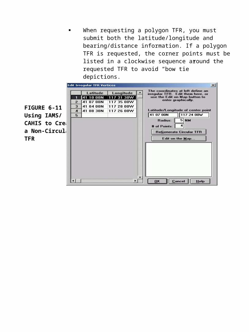
When requesting a polygon TFR, you must submit both the latitude/longitude and bearing/distance information. If a polygon TFR is requested, the corner points must be listed in a clockwise sequence around the requested TFR to avoid “bow tie” depictions.
FIGURE 6-11 Using IAMS/ CAHIS to Create a Non-Circular TFR

Example of a Polygon TFR - Biscuit Fire, Summmer of 2003 (NOTFORNAVIGATIONAL PURPOSES) 2/9926 – OR.. Flight Restrictions Gold Beach, OR. Effective immediately until further notice. Pursuant to 14 CFR 91.137A (2), Temporary Flight Restrictions are in effect from 423900N/1235300W (OED 267 044) to 423837N/1234840W (OED 267 041) to 421730N/1233700W (OED 233 033) to 420000N/1234730W (OED 217 049) to 420116N/1240125W (OED 224 056) to 421600N/1241730W (OED 242 062) to 422430N/1241730W (OED 249 061) to 423900N/1235300W (OED 267 044) at and below 8,000 ft MSL to provide a safe environment for fire fighting aircraft operations. US Forest Service, phone 541-471-xxxx./Freqs 134.825 W of 123570W/134.225 E of 1235730W, is in charge of on scene emergency response activities. McMinnville / MMV/ AFSS, Phone 503-474-xxxx is the FAA coordination facility. WIE until UFN.
6. Getting the Incident Name in the TFR
If you elect to use the IAMS/CAHIS, ROSS or other customized forms, include the following sentence that has been approved by the FAA:
“The ______________ (Agency Name)/________________(Incident Name) at ________________ (24 hour Phone number – no Toll Free Numbers), ______________________ (VHF AM Air/Air Frequency) is in charge of the on scene emergency response activities. TFR is to provide a safe environment for fire fighting aircraft operations, effectively immediately, until further notice, 24 hours/day.”

FIGURE 6-14 Overlapping TFRs FIGURE 6-15 Solution to Overlapping TFRs
7. MSL Altitude Only
Altitude must be given to the FAA as MSL. A rule of thumb is that the “top” of the TFR is 2,000’ above the highest elevation on the incident or 2,000’ above the highest flying aircraft on the incident. Note – Some areas and IAMS/CAHIS uses 3,000’ as a standard.
Convert to MSL so that it gives the TFR a “hard top.” Coordinate with the Air Tactical FS, ASM or lead plane to make this decision.
8. Frequency
Add the VHF-AM air-to-air frequency to your TFR request and ask that the FAA publish the frequency.
Monitor your TFR and keep the FAA notified if the frequency changes. Should the frequency change, cancel the TFR and issue a new one.
B. Sharing the Information
1. Relay information on identified airspace hazards or concerns to pilots and or on-scene aviation personnel. Ensure that radio frequencies are known to enable communications over an incident.

2. If neighboring agencies are impacted, coordinate TFR order with them. Share frequencies. Determine if requested TFR will affect current TFRs already in place. Combine if necessary. Do not overlap TFRs.
If MTRs are impacted, call the DoD Scheduling Activity and determine status (“hot”) and their schedule for the remainder of the day. Relay MTR status immediately to all incident air crews. Inform DoD of intent to request TFR.
If a SUA is impacted, consult agreements between military and land management agency if such an agreement is in place. If no agreement is in place, consult with ARTCC and/or Scheduling Agency for procedures to deconflict airspace.
A TFR is as restrictive to military flights as to any other nonparticipating aircraft. It is strongly recommended when TFRs are located near or in SUA and/or MTRs, notifications to affected military units be made prior to the request for a TFR from the FAA ARTCC. Military aircraft already airborne when a TFR is requested may not be in communication with the notified facilities. Do not assume the TFR is deconflicted without verification that military aircraft have been cleared from the affected airspace.
If an airport is impacted, notify the incident Air Operations Branch Director (AOBD). TFR’s do not close an airport and VFR traffic is allowed inside a 91.137(a)(2) TFR to and from an airport. Coordinate with AOBD and airport manager for ingress/egress or closure (worse case scenario).
3. Brief local and non local initial attack and other participating aircraft on procedures for entering airspace (Initial points of contact for entry, etc). For further information, see Chapter 7, Airspace Deconfliction, and the Interagency Air Tactical Supervisors Guide.
FIGURE 6-16 Example of a Complex Fire Season Resulting in Sharing TFR Information Between Agencies
C. FAA Procedures
1. Furnish the TFR information to the ARTCC and, as appropriate, to the military, via phone. It is also strongly recommended that copies be faxed to offices involved. A hard copy often clarifies any information relayed verbally. If faxed, requests must be followed up by verbal confirmation.

2. The ARTCC sends the TFR request to US NOTAM Office who in turn approves and issues the NOTAM to FSS. Because of processing time, the NOTAM is not normally published for at least two hours. The agency should consider requesting from the FSS an FSS issuance of an advisory NOTAM concerning the activity until such time as they receive the official TFR.
3. Verify the TFR was published as requested through the US NOTAM Website at https:/www.notams.jcs.mil or https:/www.notams.faa.gov (these are mirrored websites). Document the NOTAM number on the resource order and TFR request form. If the approved TFR differs, contact the ARTCC to resolve the difference. It could be a typographi-cal error that needs correction. Final approval, with any changes, will be passed to all affected personnel.
C. Maintenance
1. Maintain contact with FAA and DoD daily to ensure that TFR and requested deconfliction is still in effect.
2. Coordinate modification with on scene personnel and determine size or shape as the incident or project size changes. When the project has changed size or shape of airspace, the TFR NOTAM is cancelled and a new NOTAM is issued for the revised TFR. Modifications to a TFR require coordination with the affected ARTCC, FSS, GACC, and military units. Follow the steps listed above and document on the resource order that the TFR has been replaced by a new TFR. Repeat as necessary.
Be Sure To: Follow agency procedures for contacting the FAA when the TFR frequencies
change. The FAA will cancel the current TFR and issue a new TFR with the correct frequency.
Notify involved aircraft, agency and neighboring agencies of frequency changes.
Do NOT Use TFRs for Burned Area Emergency Rehabilitation (BAER) projects. They do not qualify under 91.137(a)(2)

D. Modify/Cancellation
1. When the incident no longer requires protected airspace, the TFR is canceled. Modifications and cancellations to a TFR require coordina-tion with the affected ARTCC, FSS, GACC, and military units. Be sure to notify all involved DoD units that the TFR has been cancelled.
2. If problems are encountered, document on a SAFECOM and follow agency procedures. If airspace becomes unsafe, it is the responsibility of the individual who is aware of the hazard to ensure operations are temporarily suspended until the conflict is resolved. See Chapter 8, Airspace Conflicts, for further information.
VI. Notification Process
As part of the deconfliction process, agency personnel need to notify both military and agency involved aircraft who may be in or near the identified TFR. Additional deconfliction information contines in Chapter 7, Airspace Deconfliction.
A. Military Notifications of a TFR
1. Notify the appropriate military facility of the TFR or need to deconflict an area. This may be the scheduling agency (SUA) or scheduling activity (MTRs) or the identified military Points of Contact (POCs).
2. In some cases this contact may be an advisory but, when addressed by MOU or other agreements, the purpose may be to request deconfliction of military flight operations in the affected area, through closed routes or otherwise restricted military operations.
3. Once the TFR or notification/deconfliction has been coordinated, the individual responsible for the restriction should, on a daily or more frequent basis, check and update this information with all affected military units.
4. Information to provide includes but is not limited to:
Agency flight operations including TFRs and other activity that may affect flight safety located in or near an MTR or SUA
Flights to and from an air tanker base (known as “load and return” or “round robin”) where the air tanker base may not be inside the TFR
Routes of ingress and egress Frequencies, type and number of aircraft involved
5. For non-time critical operations, the military unit may schedule/ deconflict land management agency aircraft into the MTR/SUA area using normal scheduling procedures. For time critical operations, military pilots are briefed or otherwise contacted. The military should be requested to notify the requesting agency when all military aircraft have been confirmed clear of the area.
B. Agency Notifications of a TFR
It is imperative that agency personnel keep agency aircraft flight operations aware of TFR or other flight advisories. Local real time advisories of TFR or flight operations and of other activity affecting airspace should be forwarded to agency pilots, managers, and/or ground personnel involved in aviation (i.e. smokejumper, air tanker and helibases).
C. Briefings
Notification to local pilots and personnel is necessary to insure TFR, advisory NOTAMs, and other information affecting airspace is provided in real time.
Morning and evening briefings should included current TFR areas, recent near mid air collisions, hazards and obstacles related to airspace. For further briefing information, refer to Chapter 7, Airspace Deconflictions.

12 Step Basic Checklist for Implementing a TFR
FIGURE 6-17 Basic TFR Checklist
Basic Checklist For Implementing TFRs Incident: ________________________ By:_______________ Date: __/__/__
Action To From Date Time
1 Determine need for TFR and/or deconfliction by the military.
2
Plot incident or project locations using maps and/or computer system; Determine Hazards if special-use airspace or military training routes involved, perform steps 6 and/or 7 prior to steps 4-5.
3
Complete resource order with Interagency Request Form for TFR and document contacts requesting deconfliction of airspace with DoD.
4 Contact FAA ARTCC with request for TFR; request callback with confirmation.
5 Inform FAA FSS of request made to ARTCC. Request advisory NOTAM if necessary.
6
If Special-Use Airspace (MOAs, RAs, etc.) involved, contact Military Scheduling Agency and request deconfliction of airspace until TFR granted by FAA
7
If MTR(s) involved, contact Military Scheduling Activity and request deconfliction of airspace until TFR granted by FAA.
8 Relay copy of TFR request to GACC if appropriate.
9
Relay status of TFR and airspace to all aircraft and Incident Commander, and if appropriate, activity status of SUA and MTRs.
10
Document call-back confirmations received on the "Interagency Request for Temporary Flight Restriction" and document DoD contacts.
11 Check TFR Status Daily with the incident, FAA and DoD.
12 Amend and Cancel when necessary

INTERAGENCY REQUEST FOR TEMPORARY FLIGHT RESTRICTION (TFR request must be phoned in as per FAA. This form may also be FAXed to provide documentation.) � Check if this TFR is a replacement. If so, NOTAM # of TFR being replaced. _________________________ (Existing TFRs can not be changed, only cancelled and replaced.) Geographic Location of Incident (nearest town, state) ___________________________________________________
OR (Polygon TFRs should be rare and only used if circular shape is not adequate.)
Altitude restrictions: ____________ FEET MSL (do not use AGL – Standard is 2000’ above highest terrain point) The _______________________/___________________ at _____________________ , ___________________ Agency Name Incident Name 24 Hr. Phone # (No Toll Free #s) VHF-AM Air/Air Frequency is in charge of on scene emergency response activities. TFR to provide a safe environment for fire fighting aircraft operations; effective immediately, until further notice, 24 hrs/day. IMPORTANT NOTE TO FAA: If the TFR affects SUA and/or MTR(s), we request NOTAM distribution to all military bases involved, to the Coordinating Flight Service Station, and, for MTRs, to the Flight Service Station and Air Route Traffic Control Center with responsibility for the airspace at the route entry point(s). NOTAM # ________________________ ISSUED AT ____________ (Time) On _______/_______ (Date) Date/Time TFR Cancelled: ________________ By: _____________________ Rev.09-07-02
RESOURCE ORDER NUMBER: Request #: A DATE: TIME:
TO: FAA ARTCC ________________________________ FAA PERSON CONTACTED: _____________________________ FAA PHONE:____________________ FAX:_________________
FROM: DISPATCH OFFICE ________________ PERSON REQUESTING TFR: __________________ 24 HR. PHONE (No Toll Free #s) ___________________
Location (Circular TFR) List nearest NAVAID (distance should be less than 50 NM) - do not use NDB or T-VOR. VOR ID
RADIAL (Degrees)
DISTANCE (NM)
LAT/LONG of Center Point (use US NOTAM OFFICE FORMAT ddmmssN/dddmmssW)
RADIUS (NM) (5 NM is standard)
N/ W
Location (Polygon TFR) (List perimeter points in clockwise order) List nearest NAVAID (distance < 50 NM) - do not use NDB or T-VOR.
Point #
VOR ID (XXX)
Radial (Degrees)
Distance (NM)
Lat/Long ddmmssN/dddmmssW
Point #
VOR ID (XXX)
Radial (Degrees)
Distance (NM)
Lat/Long ddmmssN/dddmmssW
1 N/ W 5 N/ W
The requested TFR affects the following Special-Use Airspace: The requested TFR affects the Military Training Routes listed below: Route SCHEDULING ACTIVITY SEGMENT(S) Route SCHEDULING ACTIVITY SEGMENT(S)


VII. BLM Airspace Information System