chapter 1 - grove park neighbourhood forum · page 8 of 52 contents 1 neighbourhood planning...
TRANSCRIPT

RINGFIGU
Chapter 1 Introduction to Grove Park Grove Park Neighbourhood Plan
MAY 2017 | PRE-SUBMISSION DRAFT

Page 2 of 52
Mapping Futures E [email protected] M +44 (0) 7834915165 W https://mappingfutures.org/ T @MappingFutures Changing Cities E [email protected] M +44 (0) 7889 392 786 W http://changingcities.co.uk/
© Grove Park Neighbourhood Forum
Date Published May 2017 – Pre-submission version The Grove Park Neighbourhood Plan (Pre-submission version) has been prepared with the help of Mapping Futures with Changing Cities, and with contributions from associate colleagues James Hulme and Imogen Humphris. It is, however, a collective effort, involving much input and text from the residents themselves. All maps are reproduced from Ordnance Survey mapping with the permission of the Controller of Her Majesty’s Stationery Office © Crown copyright. Unauthorised reproduction infringes Crown copyright and may lead to prosecution or civil proceedings. Lewisham Council Licence No: LA075221 applies. All other data is open source from online locations, referenced as footnotes throughout the documents. For more information contact:
Grove Park Neighbourhood Forum E [email protected] W http://www.groveparkneighbourhoodforum.com/ T https://twitter.com/groveparknforum

Page 3 of 52
Acknowledgements The Grove Park Neighbourhood Plan was made possible with the dedication and many hours of volunteered time from the Steering Committee, in particular Rob Clayton, Jan Quirke, Barry O'Donovan, and the wider Neighbourhood Forum members, in particular Helen Pink. The Neighbourhood Steering Committee would like to thank the organisations who provided technical support and consultancy services and/or advice, including: Prince’s Foundation, Imagine Places, AECOM, Locality, DCLG, The Baring Trust and Mapping Futures with Changing Cities. A special thank you goes to Grove Park Community Group (GPCG), and The Crown Tavern and the Baring Hall Hotel public houses for supporting the Forum’s work by providing venue space during the engagement events. Thank you also goes to all three ward assemblies and all the ward Councillors for their support throughout the process. Additionally, a heartfelt thanks goes to the many, many supportive local residents and the national and international visitors who volunteered their time to make this plan possible: GPCG, Just Space network; students and staff from University College London (UCL) (Archaeological Department, Archival Studies, Bartlett School of Planning, Development Planning Unit); the National Trust; the National Railway Museum; the Science Museum; The London Wildlife Trust; Edinburgh Royal Observatory; Heritage of London Trust; SAVE Britain’s Heritage; Ancient Monument Society; Lewisham History Society. We would also like to thank the ARCC Network and the Feeling Good Foundation for inviting us to attend an inspiring seminar series on how to design and deliver healthier places. A special thank you goes to our local historian, John King, for his support and knowledge on Grove Park, whose books (Grove Park: A History of a Community (1982) and Grove Park: Its History Revisited (2011) have been an invaluable source of information about the heritage of our neighbourhood.
Credits Ordnance Survey 1:1250 mapping was used under an End-User License from Lewisham Council Licence No: LA075221. Other Crown Copyright mapping used with permission for use / reproduce provided by a Click-Use Licence obtained from HMSO when downloading the data (www.clickanduse.hmso.gov.uk). All sources of information are acknowledged. All sources of open source data cited in figures and footnotes throughout the documents. Photos (unless otherwise stated) were captured by Mapping Futures Ltd for the purposes of producing the neighbourhood plan publication, under a creative commons license. Future use should cite origin. Photographs by local photographer ©Rob Clayton acknowledged. John King, the Grove Park Community Group and The Baring Trust have also kindly contributed historic photography. Engineering drawing of the Jinty train used in the Railway Children was kindly provided by the National Railway Museum, who granted permission for its use in the Neighbourhood Plan.
Page 4 of 52
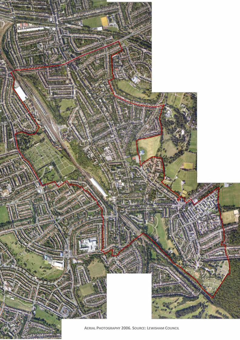
AERIAL PHOTOGRAPHY 2006. SOURCE: LEWISHAM COUNCIL
Page 5 of 52
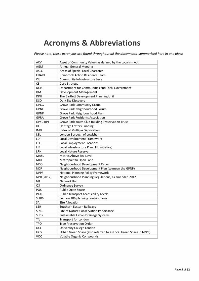
Acronyms & Abbreviations Please note, these acronyms are found throughout all the documents, summarised here in one place
ACV Asset of Community Value (as defined by the Localism Act)
AGM Annual General Meeting
ASLC Areas of Special Local Character
CHART Chinbrook Action Residents Team
CIL Community Infrastructure Levy
CS Core Strategy
DCLG Department for Communities and Local Government
DM Development Management
DPU The Bartlett Development Planning Unit
DSD Dark Sky Discovery
GPCG Grove Park Community Group
GPNF Grove Park Neighbourhood Forum
GPNP Grove Park Neighbourhood Plan
GPRA Grove Park Residents Association
GPYC BPT Grove Park Youth Club Building Preservation Trust HLF Heritage Lottery Funding
IMD Index of Multiple Deprivation
LBL London Borough of Lewisham
LDF Local Development Framework
LEL Local Employment Locations
LIP Local Infrastructure Plan (TfL initiative)
LRN Local Nature Reserve
MASL Metres Above Sea Level
MOL Metropolitan Open Land
NDO Neighbourhood Development Order
NDP Neighbourhood Development Plan (to mean the GPNP)
NPPF National Planning Policy Framework
NPR (2012) Neighbourhood Planning Regulations, as amended 2012
NR Network Rail
OS Ordnance Survey
POS Public Open Space
PTAL Public Transport Accessibility Levels
S.106 Section 106 planning contributions
SA Site Allocation SER Southern Eastern Railways
SINC Site of Nature Conservation Importance
SuDs Sustainable Urban Drainage Systems
TfL Transport for London
TPO Tree Preservation Order
UCL University College London
UGS Urban Green Space (also referred to as Local Green Space in NPPF)
VOC Volatile Organic Compounds
Page 6 of 52
Foreword “It’s surely our responsibility to do everything within our power to create a
planet that provides a home not just for us but for all life on earth” Sir David Attenborough, Planet Earth II
I have been a resident in Grove Park for almost fifty years. During this time the Grove Park that I grew up
in has slowly been losing its character and charm. Change is inevitable, and while we embrace it, residents
here feel strongly that it has to be a change that benefits all!
Embarking on neighbourhood planning started for us before the Localism Act in 2011 when collectively,
residents prevented Grove Park from being destroyed by a motorway; saved The Baring Hall Hotel from
demolition and provided evidence for the London Plan to protect pubs across London, and yet again more
recently protected our sites of nature conservation importance.
The Grove Park Neighbourhood forum considers a different vision where Grove Park residents, workers
and volunteers all have a say and are proactive rather than reactive to the recent wave of developers who
may ‘consult’ but do not have our community interests at the heart of their investments or speculations.
This plan supports the concept of a masterplan for Grove Park with an Urban National Park being the
gateway to the ‘Garden of England’, comprising a continuous linear nature trail starting from our chalk
grasslands to the white cliffs of Dover, and supported by sustainable transport connections. We would like
new developments to take into consideration biophilic design practices, clean air and humanised design;
putting its residents first, and making Grove Park once again a destination for culture. Once home to
residents and visitors such as Edith Nesbit and George Bernard Shaw (founding members of the Fabian
Society); cricketer W.G. Grace and Archbishop Desmond Tutu, to name a few, we want Grove Park to
inspire a new generation capable of great acts. We envisage the possibility of having our very own Railway
Children museum, showcasing and celebrating our wonderful cultural history.
Rekindling with its history, we have come to learn a lot about the neighbourhood’s past and present
residents; its Arts and Crafts architecture by distinguished architects such as Ernest Newton OBE; and the
movements which inspired its growth as an artistic suburb. Some of these features are now distant
memories, but ones which are firmly engraved into Grove Park’s heritage and strong sense of place that
brings together its different communities time and again for planning a better neighbourhood.
Our introductory Chapter 1 shows key stages in our Neighbourhood’s history. The publication of our
Neighbourhood Plan marks another milestone and chapter for Grove Park. After five plus years of hard
work, challenges, planning inspectorate hearings - all ruling in our favour - numerous creative workshops,
and the invaluable help from many volunteers, we present our Neighbourhood Development Plan as our
vision for a healthy and thriving Neighbourhood. Having lost notable and distinguished buildings of merit
and community services, our plan sets out a clear path to improve and enliven our Neighbourhood once
more and looks forward to working with Lewisham Council towards this end.
I will end with the quotation below from a true local hero, family friend and mentor to me; from whom I
have drawn much inspiration and guidance and without him and other elders, Grove Park would not have
the landscape for an Urban National Park that inspired this plan.
“If we won’t fight for our homes and surroundings nobody else will” Mr. Jeff Cox (Chair of GPRA) – Lewisham Life, My Lewisham, January 1998
S.F Kenny, May 2017

Page 7 of 52
LOCAL ARTIST’S IMPRESSION
DRAWINGS OF GROVE PARK
AS A KEY NEIGHBOURHOOD
DESTINATION
(TOP) CONNECTING GROVE
PARK’S URBAN NATIONAL PARK
TO THE COUNTRYSIDE OF KENT
(‘GARDEN OF ENGLAND’); (MIDDLE) THE RAILWAY
CHILDREN 1890 JINTY-TYPE
ENGINE, COURTESY OF THE
NATIONAL RAILWAY MUSEUM; (BOTTOM) INVITATION TO THE
FUTURE ‘THE RAILWAY
CHILDREN FESTIVAL’
Page 8 of 52
Contents
1 Neighbourhood Planning in Grove Park ........................ 10
1.1 Purpose of Document ................................................................................................................. 10
1.2 Why a Neighbourhood Plan for Grove Park? ............................................................................... 10
1.3 What is Unique About Grove Park? ............................................................................................. 15
1.4 Key Dates.................................................................................................................................... 16
2 Location Context ............................................................ 17
3 Historic Context .............................................................. 19
3.1 Introduction ............................................................................................................................... 19
3.2 Neighbourhood Origins ............................................................................................................... 20
4 Environment and Landscape Heritage ........................... 26
4.1 Topography ................................................................................................................................ 26
4.2 Hydrology ................................................................................................................................... 26
4.3 Landscape................................................................................................................................... 26
4.4 Habitats ...................................................................................................................................... 28
5 Built Heritage ................................................................. 31
6 Industrial & Economic Heritage ..................................... 36
7 Cultural & Social Heritage .............................................. 37
7.1 Attracting the Aesthetic Movement ............................................................................................ 37
7.2 Literature.................................................................................................................................... 38
7.3 Celebrating Grove Park’s Heritage ............................................................................................... 39
7.4 Sporting Connections .................................................................................................................. 42
7.5 The Communities and Social Activism ......................................................................................... 43
8 Policy Context................................................................. 47
8.1 Area of Stability and Management Change .................................................................................. 47
8.2 Open Space ................................................................................................................................ 47
8.3 Neighbourhood Centres .............................................................................................................. 49
8.4 Community Facilities ................................................................................................................... 50
8.5 Housing ...................................................................................................................................... 50

Page 9 of 52
List of Figures Figure 1: Timeline of ‘Managed Change’ in Grove Park ........................................................ 14
Figure 2: Location Context of the Grove Park Neighbourhood Plan Area.............................. 18
Figure 3: Topography of Grove Park .................................................................................... 30
Figure 4: Dwelling Modal Age Map ...................................................................................... 35
Figure 5: The Grove Park Heritage Trail Map ....................................................................... 40
Figure 6: Various Community Campaigns ............................................................................ 46
Figure 7: Lewisham Local Plan Policies Map. December 2015 Version ................................. 51
`
List of Tables Table 1: Key Dates in the Evolution of Grove Park’s Neighbourhood Plan ............................ 16
Table 2: Existing Open Space Site Allocations / Designations in Grove Park ......................... 49

Page 10 of 52
1 Neighbourhood Planning in Grove Park
“Grove Park is crying out for investment. Harnessing the aspirations of the community and working with local landowners will be key to unlocking change”
Heidi Alexander, MP East Lewisham, 2012
1.1 Purpose of Document This document forms Chapter 1 - An Introduction to Grove Park as a London neighbourhood.
It aims to give a broad overview of the neighbourhood’s geographic and historic context as a
basis for highlighting what is unique about the area and therefore, how its distinctive
qualities should inform future development. Places which enhance their local distinctiveness
manage to thrive and be places where people want to live and visit – contributing to their
sustainable development.
1.2 Why a Neighbourhood Plan for Grove Park? Lewisham Council’s Core Strategy classifies Grove Park as ‘an area of stability and managed
change’. The residents of Grove Park feel that neither ‘stability’ nor ‘managed change’
reflects what has been happening in Grove Park over the last decades. The residents feel
strongly that instead, the area has been suffering degradation of its facilities and services as
well as of its heritage assets.
Residents came together as a united voice to set out their own vision for how this ‘stability
and managed change’ should occur; this process started well before neighbourhood
planning existed as a legal vehicle for action.
Acting together as the Grove Park Community Group (GPCG)1, and later as a constituted
Neighbourhood Forum2, the residents set about to create their own Neighbourhood Plan.
Table 1 sets out the key dates in this process. More recently, another key group working on
addressing neighbourhood issues is the Chinbrook Action Residents Team (CHART)3, focusing
specifically on the Chinbrook Estate.
1 Grove Park Community Group (GPCG) - http://www.gpcg.org.uk/ 2 Grove Park Neighbourhood Forum (GPNF) - http://www.groveparkneighbourhoodforum.com/ 3 Chinbrook Action Residents Team (CHART) - http://www.chartbiglocal.org.uk/
Page 11 of 52
Despite some feelings of neglect and disenfranchisement, Grove Park residents have a
unifying story to tell, which they have shared and incorporated into their neighbourhood’s
vision with the hope of inspiring the next generation of residents. There are a series of parts
to their story and it begins with an inspiring heritage: Grove Park was developed for Lord
Northbrook by Ernest Newton in the manner of Bedford Park. Grove Park is the literary
inspiration for the plot of ‘The Railway Children’ and other children’s books by Edith Nesbit.
It was home and a meeting place to a strong network of social activists such as Nesbit, Shaw,
Bland and Steele; their ethos continued with Jeff Cox and other residents, who many years
later fought against the Ringway 2 proposal, an urban motorway that would have severed
the community and south-east London. This community spirit keeps the sense of community
alive today.
Residents speak about Grove Park as a family-centred neighbourhood where community
facilities once thrived but have since been in decline due to a lack of investment. They
believe their greatest asset is their ‘country-like’ open spaces with vast opportunities for
outdoor activities, recreation and learning. Equally prevalent is the enterprising ethos of the
people living here, with numerous examples of start-ups using lock up garages. The biggest
issues, but also the biggest opportunity they see, is the revival of their ‘town centre’.
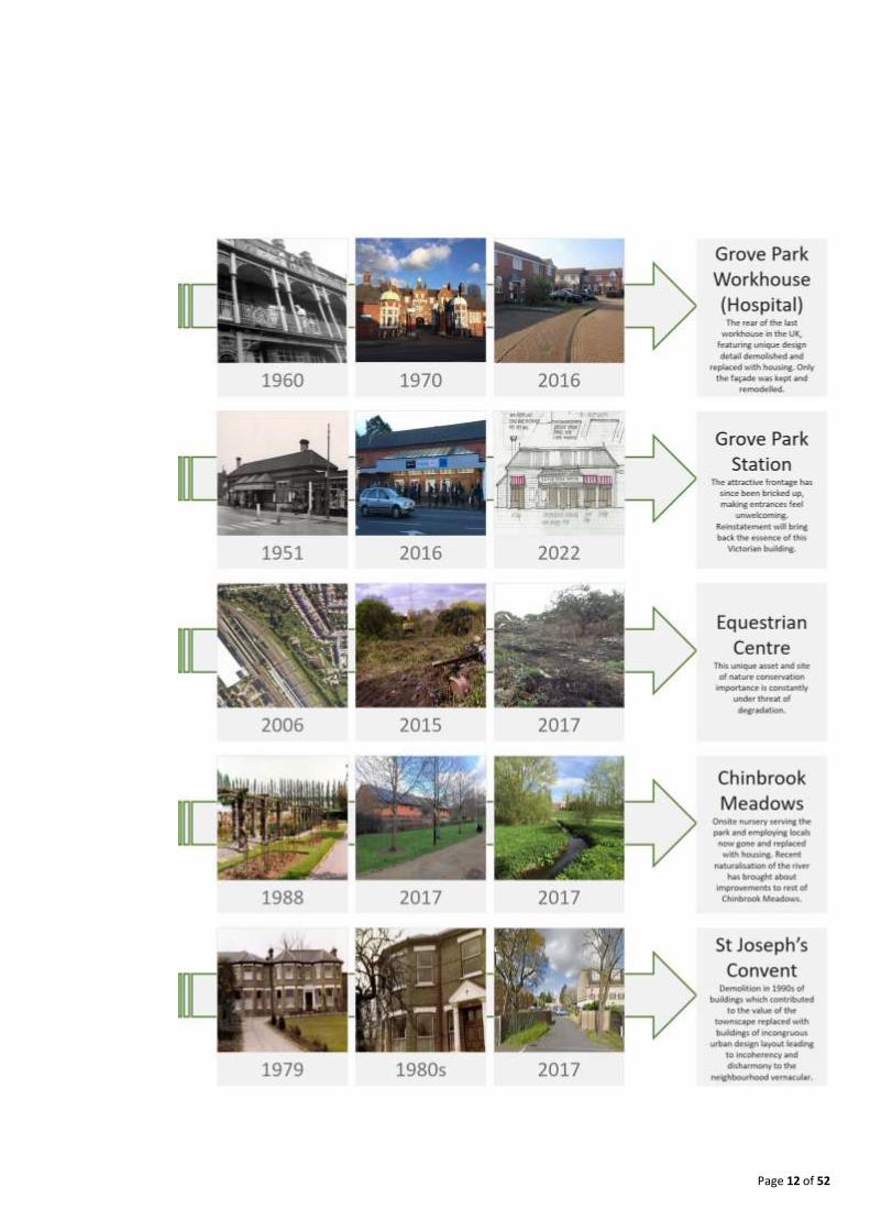
What follows is a timeline (Figure 1) compiled by residents to illustrate their point about how
much loved buildings and facilities have since been demolished or left to decline and
deteriorate.
Page 12 of 52

Page 13 of 52

Page 14 of 52
FIGURE 1: TIMELINE OF ‘MANAGED CHANGE’ IN GROVE PARK

Page 15 of 52
1.3 What is Unique About Grove Park? The sections that follow describe the neighbourhood’s origins and key features which the
plan seeks to highlight. Its unique qualities can be summarised as:
The natural wilderness of the railway sidings, providing a variety of habitats including chalk grassland, willow woodland, a mixed woodland, pond habitat, wildflower meadows and wet meadows. This unique linear expanse has the potential to be a key feature in Grove Park, with a nature trail running through to connect the different ecosystems. Residents see this as their ‘Urban National Park’, linking their nature reserves with the woodlands at Elmstead Woods and beyond into Kent (‘the Garden of England’).
Grove Park developed rapidly in the 1930s with some streets displaying good examples of 1930s Arts and Crafts architecture and landscaped streets with grass verges – a rare scene in today’s streetscapes.
Its cultural history and literary connections. As the ‘home of the Railway Children’, residents would like to plan for more cultural events to take place, like the setting up of their own Railway Children Museum.
The community spirit and cultural heritage continues to inspire innovative and enterprising endeavours, such as the outdoor learning and literacy classes at Camp Nesbit, the Heritage Trail map and the formation of building preservation trusts to safeguard key buildings of townscape merit.

Page 16 of 52
1.4 Key Dates Table 1 shows the key dates that were precursors to the establishment of Grove Park’s
neighbourhood planning process.
Date Milestone Achievement
15th September 2011 Local listing, with an Article 4 Direction approved for the Baring Hall Hotel, 368 Baring Road, SE12 0DU.
February 2012 Grove Park Community Group, supported by the Prince’s Foundation (Communities and Neighbourhoods in Planning Programme) work on a masterplan for the town centre.
5th October 2012
Decision of Inspector to reject the planning application for flats and demolition of the Baring Hall Hotel. This came after many years of campaigning by local residents to save their pub and the essence of their high street.
January 2013
A Grove Park stakeholder meeting was held to discuss the dilapidation of the Grove Park station bridge, and to understand why nothing appeared to be happening about the poor state of repair. This was an action arising from the Prince’s Foundation work. Public realm work cannot commence without resolving the issues with the bridge. What transpired relates to a complex ownership setup, meaning that 4 years later the issues remain unresolved.
25th April 2013
Lewisham Council’s Transport team commissions a detailed public realm design for Grove Park Neighbourhood Centre, leading to gaining grant funding of £1.2 million of planned investment in autumn 2014, now delayed.
14th January 2013 The Baring Hall Hotel (including the main building, stable block and curtilage of the public house of title number TGL 180413) is registered as an Asset of Community Value – the first in Lewisham!
18th December 2013
Reopening of the locally listed and Asset of Community Value – the Baring Hall Hotel. A young team from Antic has brought back the social hub at the heart of the Grove Park community. This was a key milestone in the Community’s efforts towards improving their high street.
June 2014 Application for establishing a Neighbourhood Forum and Neighbourhood Plan Area accepted by Lewisham Council.
14th September 2014 The Railway Land (ref BII 15 including the Grove Park Nature Reserve and the Stables) is designated as a Dark Sky Discovery (DSD) site by the Science and Technology Facilities Council, Royal Observatory Edinburgh.
22nd October 2014 Designation of Grove Park Neighbourhood Forum and Area approved by Lewisham Council.
16th February 2015
The Planning Inspectorate dismisses the appeal by site owner of the Land at St Mildred’s Road (rear of Ronver Road and Rayford Avenue) (part of the Borough Grade II Site of Importance for Nature Conservation (SINC)) to cut down trees as the benefits of the proposed scheme “would not outweigh the harm that the appeal scheme would potentially cause to biodiversity in the local area”. Site now subject to a site wide Tree Preservation Order (TPO) No. 2012/04/1.
TABLE 1: KEY DATES IN THE EVOLUTION OF GROVE PARK’S NEIGHBOURHOOD PLAN
Page 17 of 52
2 Location Context
The Grove Park Neighbourhood Plan (GPNP) area is located in the south-eastern end of
Lewisham, bordering Greenwich to the north-eastern end and Bromley to the south-east.
While Lewisham is considered an inner-London borough, Grove Park, being on the edges of
travel zone 4, is perceived and can feel like an outer London destination. There are three
post code districts in the neighbourhood area: SE12 (typically identified as Lee); SE9, in the
south covering the Chinbrook Estate area; and part of BR1, around Downham Way.
The majority of the neighbourhood area falls within the ward of Grove Park; however, it also
extends slightly beyond the railway line into the Whitefoot and Downham administrative
wards on the western side.
In the autumn of 2013, the estate around the Chinbrook Meadows park became the
beneficiaries of the Big Local fund, with the area inside the designated boundary being
awarded £1 million towards improving their neighbourhood. This Big Local sub area forms an
additional governance boundary for neighbourhood improvement - see Figure 2.

Page 18 of 52
London Lewsham Grove Park Neighbourhood Area Chinbrook Big Local Area
FIGURE 2: LOCATION CONTEXT OF THE GROVE PARK NEIGHBOURHOOD PLAN AREA
Page 19 of 52
3 Historic Context
“It was probably in the closing years of the nineteenth century that Grove Park was at its most elegant and select disposition”.
John King (2011)
3.1 Introduction Much of Grove Park’s historic context is covered in both the Prince’s Foundation report and
the heritage and character assessment undertaken by AECOM. Below are some additional
references that residents have researched and extracted from various sources, pointing to
the significance of the heritage elements of the Neighbourhood Plan.
Ernest Newton (1890). A Book of Houses.
Ernest Newton (1925). The Work of Ernest Newton, RA.
Edgar Jepson (1937). Memoirs of an Edwardian and Neo Georgian.
Anthea Bell (1960). E. Nesbit.
Doris Langley Moore (1967). E. Nesbit. A
Biography.
Mark Girouard (1977). Sweetness & Light, The Queen Anne Movement 1860-1900.
John King (1982). Grove Park: The History of a Community, Grove Park Community Group.
Julia Briggs (1989). Life of E. Nesbit.
John Campbell-Kease (2004). Barron (Arthur) Oswald (1868–1939).
John King (2011). Grove Park: Its History Revisited, Lewisham Local History Society.
Ideal Homes: http://www.ideal-
homes.org.uk/lewisham/assets/histories/grove-park. Grove Park Community Group:
http://www.gpcg.org.uk/?p=groveparkhistory .
Page 20 of 52
3.2 Neighbourhood Origins Grove Park - its name and location - is a suburban phenomenon. As such, its growth and
physical and cultural development benefited from a number of influences, including the
growth of London and a range of figures of national and international importance. Before
the eighteenth century it was merely the southern part of the medieval parish of Lee; Grove
Park did not exist in name until the late 1800s. More information can be found online on the
Grove Park Community Group website4.
1700s. The area was predominantly woodland. Burnt Ash Lane purportedly
commemorates the fate of this woodland, burnt for charcoal in the pre-coal age. By the end
of the eighteenth century - the area now called Grove Park - was covered by the large Burnt
Ash Farm, occupying the land between present day St. Mildred’s Road to the railway line and
beyond. Burnt Ash appears to have been a single farm from 1727 until the death of its
second generation farmer Matthew Butler, when it was divided into smaller units. These
included Claypit Farm, located approximately where Chinbrook Meadows now stand, and
the adjacent Grove Farm which was located just to the west of the northern end of what
would become Somertrees Avenue and is believed to have given its name to the area.
Pottery clay from Claypit Farm was fired into sugar loaf moulds in Greenwich lime kilns by
one time tenant W. Pershouse.
Meanwhile the Manor of Lee, just north of the present day Grove Park neighbourhood
boundary, had been bought by Sir Francis Baring in 1792, bringing the whole area into the
ownership of the Baring banking family, rapidly rising into one of the most powerful in the
United Kingdom with a multiplicity of land interests including the Lordship of Lee Manor. As
one of the founders of the banking house of Baring, it might be expected that Sir Francis was
alive to the possibilities of developing the area for housing. A new road, Bromley Road (later
Baring Road) was cut early in the nineteenth century to improve communications with
Bromley and the south.
4 Grove Park History - http://www.gpcg.org.uk/?p=groveparkhistory

Page 21 of 52
THE THREE GABLES. SOURCE JOHN KING
1800s. A brickworks was established on the corner of Burnt Ash Hill and (what would
become) Winn Road around the middle of the nineteenth century to provide materials for
the development of South Lee. By the 1850s the works were in the partial or whole
ownership of John Pound, who combined the trades of brickmaking and speculative building.
He lived at Stratton Villa, Burnt Ash Hill. Houses were slowly developed along Burnt Ash Hill
by Pound and others between 1856 and 1866. In 1866 the South Eastern Railway (SER)
opened a station “Lee for Burnt Ash”. Pound, the son of a Blackheath publican, also began
to build and manage public houses which would include The Crown, the Lord Northbrook
and the Baring Hall Hotel. The SER direct line between St John’s and Tonbridge opened in the
1860s. Grove Park station opened on this line in November 1871, leading to its
transformation from an agricultural to a residential suburb. In 1879, Grove Park appeared in
name for the first time in Strong’s Bromley Street Directory. The directory entry recorded
that “Grove Park comprised but few residences, but was rapidly increasing owing to its close
proximity to and easy access from London,” (King, 1985). Buildings were mainly along Baring
Road, comprising of large villa-type residences, making the area an attractive one for
wealthy commuters.
Page 22 of 52
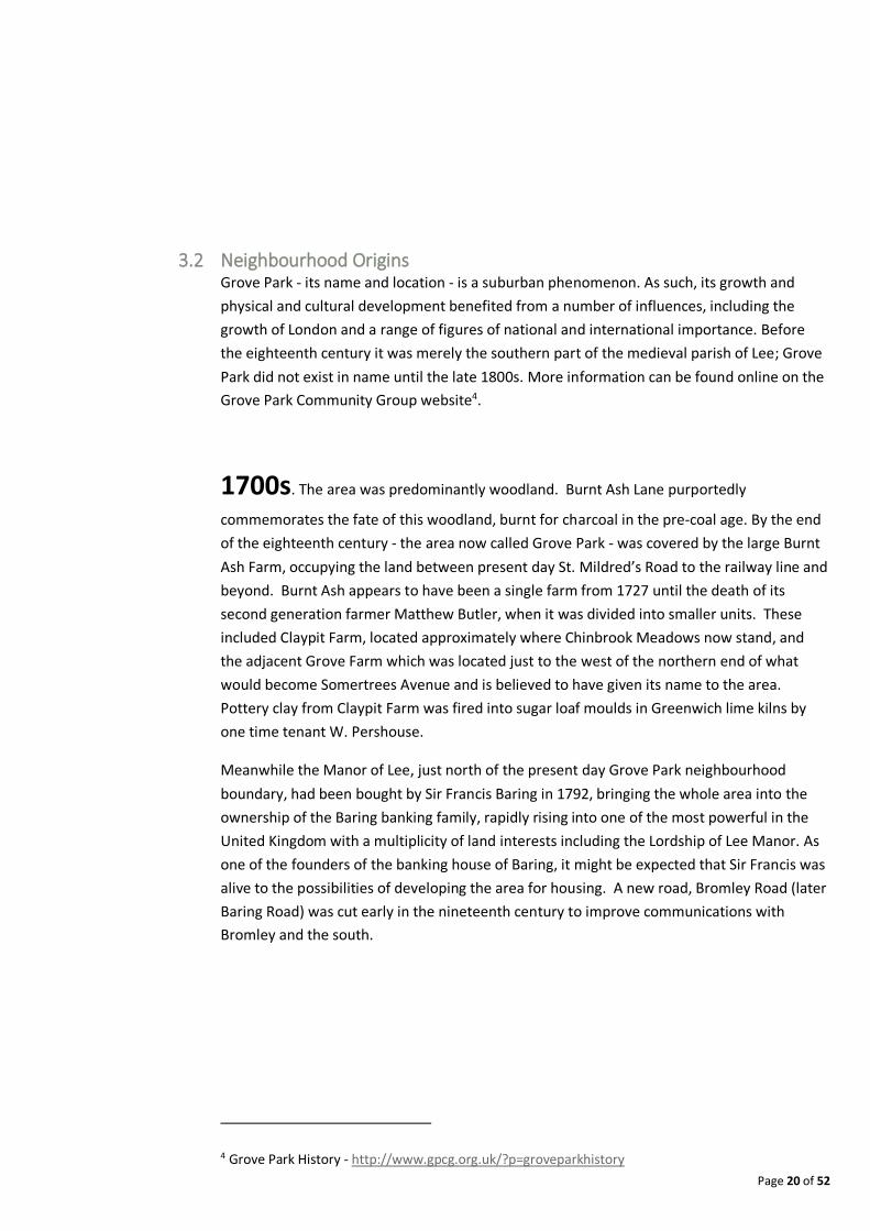
GROVE PARK STATION’S IRON FOOTBRIDGE WITH DECORATIVE SUPPORTIVE COLUMNS AND TRADITIONAL
LATTICE DETAIL -“A WELL PRESERVED EXAMPLE OF ITS TYPE WITH THE STAMP AND DATE OF W. RICHARDS
AND SON 1902.” (SAVE BRITAIN’S HERITAGE). APRIL 2013
By the First World War this middle class community, with its own parish church, had reached
its peak. The Kentish Mercury reported on the occasion of the station’s opening, “Already
several estates have roads marked out and here long will be studded with first class villas if
the splendid mansion with two acres of land lately built by Mr Pound is the accepted design”
(the house described was Saville House in Baring Road). John Pound’s influence in the area,
compounded by partnerships with Lord Northbrook and Edgar Drewett, operator of the
brickworks, was fully established with his purchase of Grove Farm in 1873 allowing ease of
development along Chinbrook Road and close to the station.
Pressure to provide a rail link from Bromley to the SER main line at Grove Park eventually
resulted in the Direct Bromley Railway Act of 1884, the line to Bromley North finally being
built and opened by the SER from 1st January 1878, (which had included an additional
station at Sundridge Park, where the Prince of Wales, later to become Edward VII, was a
frequent visitor)5.Thus within ten years the area acquired useful links both to the City and to
Bromley, a local market town. By the end of the 1870s there were approximately fifteen
villa type residencies at Grove Park.
5 Historic England Reference - https://historicengland.org.uk/listing/the-list/list-entry/1000841
Page 23 of 52
THE CROWN PUB, FORMERLY PART OF THE CROWN ESTATE. FEBRUARY 2017 ©ROB CLAYTON
The new houses were mainly on the eastern side of Baring Road (at that date the road was
called Grove Park) with three on Chinbrook Road. These were large houses designed to
attract a high class of settler, with names like Oaklands, Woodlands, The Shrubbery and The
Limes. At least one house had nine bedrooms. New businesses attracted to the vicinity were
appropriately genteel: J. W. Pegler, wine and spirit merchant; King and Otley, auctioneers;
George Hind, florist and seedsman; and J. W. Collins’ Grove Park Nursery.
When the number of houses in Grove Park passed fifty by 1885, momentum grew for the
area to have its own Anglican Church. Lord Northbrook donated an acre of land and £500 to
initiate this process in the summer of that year. The second largest contributor to the
Church Building Fund was John Pound at £300, with other residents contributing sums and
forming the committee. Plans were produced by March 1886 and, with the building fund
now reaching £2,200, the dedication stone of St Augustine’s Church was laid by the Earl of
Northbrook on 22nd May; Charles Bell was the architect.
Page 24 of 52
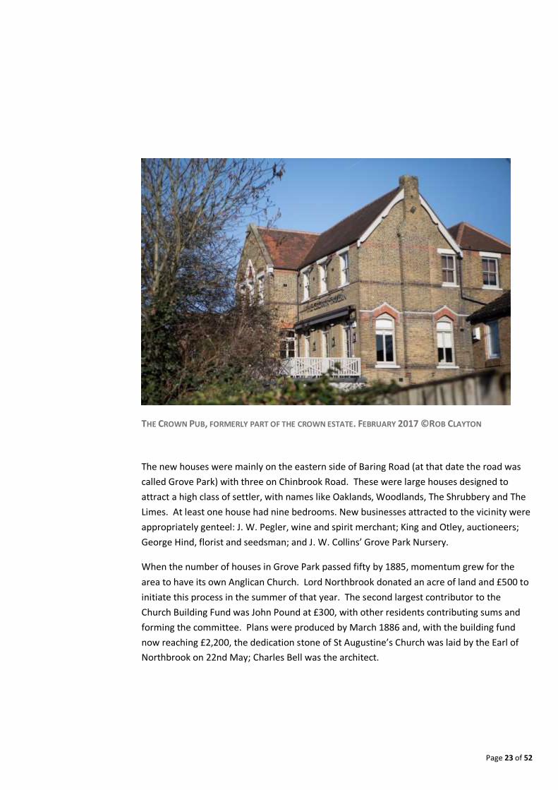
ST AUGUSTINE’S CHURCH. FEBRUARY 2017 ©ROB CLAYTON
With the creation of the parish of St. Augustine in 1891 the community entered a mature
phase of genteel seclusion for its 100 or so homes. Doctors, solicitors and businessmen
typified the social mix. The arrival of the unconventional Blands - Hubert and Edith - who
had been living nearby at 2 Birch Grove, Lee must have been a shock. Both founding
members of the Fabian society, Hubert was a rising star of journalism and Edith was on the
brink of fame as children’s author Edith Nesbit. The house they moved into on a five year
lease in 1894 was Three Gables on Baring Road (now site of Stratfield House, 260 Baring
Road), designed a little over ten years earlier by Ernest Newton.

Page 25 of 52
1900s. Whilst isolated instances of Victorian architecture remain, most of the
neighbourhood is comprised of 1930s housing, having grown rapidly in this period. Lewisham
Council built the 44 acre Grove Park Estate between 1926 and 1929, acquiring Chinbrook
Meadows for a recreation ground. Private housing was also built between the wars; the
railway to central London was electrified in 1926, making the journey to central London
faster and encouraging commuters to live in Grove Park. The last farmland was built on in
the 1960s but private sports grounds as well as Chinbrook Meadows continue to provide
open spaces.
Grove Park Hospital was built as a workhouse in 1902, one of the last to be built in the British
Isles. The designs of the workhouse in Marvels Lane received a diploma of merit for the
British when they were displayed at the Great International Exhibition in Paris in 1900 but by
this time, there had been a switch away from indoor relief. The first inmate was admitted in
1904 but the building was always under-occupied until 1914 when it was taken over by the
Army Service Corps. In 1926 it became a Tuberculosis hospital. It is now. It is now a housing
estate. The frontage and main admin block of the building were preserved and locally listed;
however, the rear was demolished, with new build houses erected in its place. Figure 4 gives
an indication of the various epochs of design in the Grove Park area throughout the 1900s.

Page 26 of 52
4 Environment and Landscape Heritage
“…one of the richest wildlife areas within Lewisham. …a large strip of relic countryside containing horse paddocks, allotments and wild unmanaged land”
London Wildlife Trust, 1985
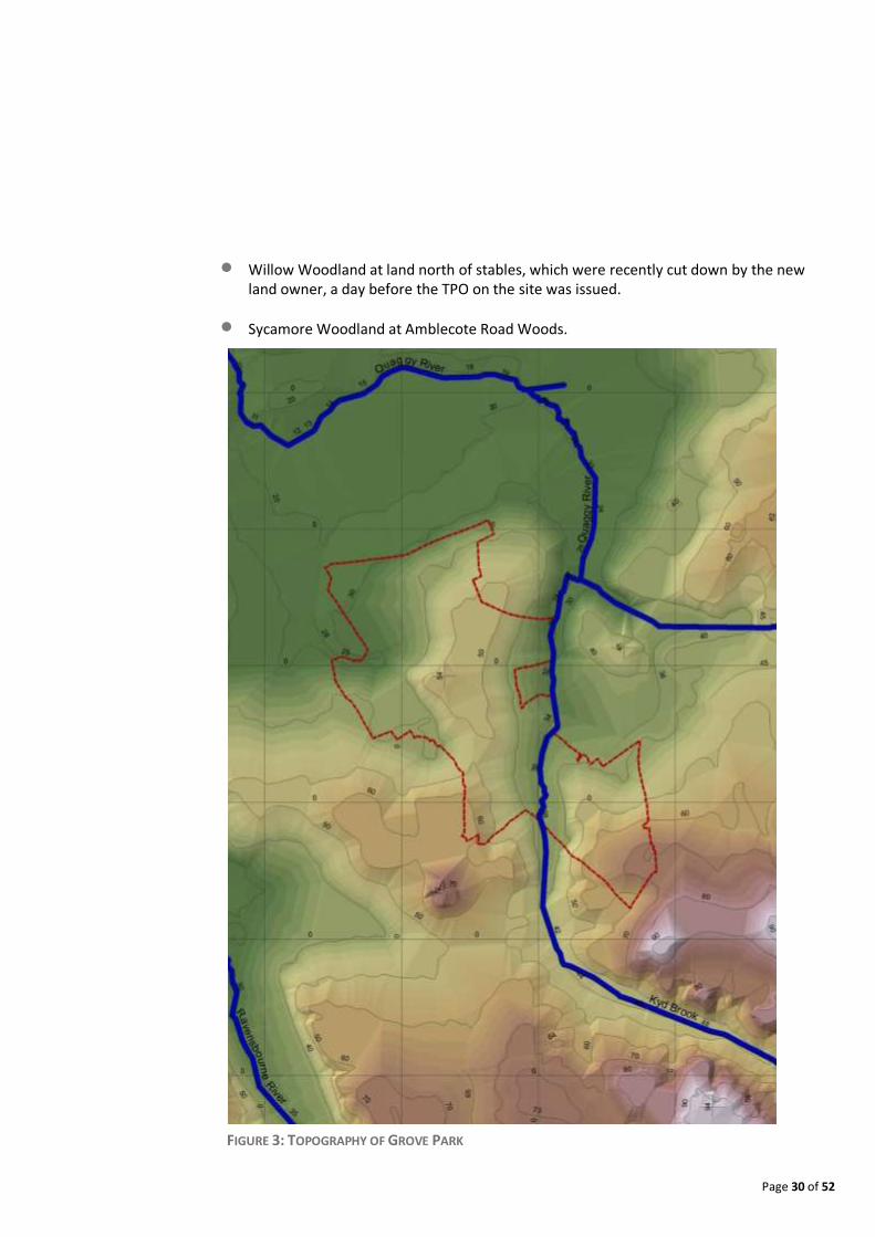
4.1 Topography Grove Park has an undulating topography, with two high points providing views to central
London: one in the centre of the neighbourhood along Baring Road (approximately 54 MASL)
and the other in the southern tip within the Grove Park Cemetery (approximately 70 MASL),
with views towards Canary Wharf (see Figure 3).
4.2 Hydrology The neighbourhood is dissected in half by the valley of the Quaggy river, within the wider
catchment area of the River Ravensbourne. Much is hidden from view and channelised
within concrete banks. The river can be seen along Sydenham Cottages Nature Reserve and
again within Chinbrook Meadows, where parts of it were recently restored back to natural
banks. An online account6 about the tributaries of the Quaggy, known as the ‘Grove Park
Ditches’, trace the origins of the river.
4.3 Landscape The railway line creates a major severance to the area, but it has also provided an
opportunity for a more natural landscape to become established along the railway cutting.
Much of this area has been used as allotment gardens, most now allowed to revert back to
scrubland. In the centre the Grove Park Nature Reserve forms a woodland canopy, with tree
cover showing since the early eighteenth century maps. In 1985, the railway sidings were
quoted as being “one of the richest wildlife areas within Lewisham. …a large strip of relic
countryside containing horse paddocks, allotments and wild unmanaged land” 7.
6 Running Past Blog. A Blog about South East London. https://runner500.wordpress.com/2016/06/23/grove-park-ditch-a-quaggy-tributary/ and https://runner500.wordpress.com/2016/07/28/grove-park-ditch-west-a-tributary-of-the-quaggy/ 7 London Wildlife Trust. “Countryside in Lewisham Under Threat” Press Release. 18 February 1985
Page 27 of 52
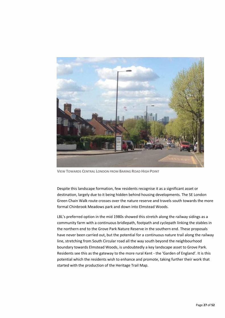
VIEW TOWARDS CENTRAL LONDON FROM BARING ROAD HIGH POINT
Despite this landscape formation, few residents recognise it as a significant asset or
destination, largely due to it being hidden behind housing developments. The SE London
Green Chain Walk route crosses over the nature reserve and travels south towards the more
formal Chinbrook Meadows park and down into Elmstead Woods.
LBL’s preferred option in the mid 1980s showed this stretch along the railway sidings as a
community farm with a continuous bridlepath, footpath and cyclepath linking the stables in
the northern end to the Grove Park Nature Reserve in the southern end. These proposals
have never been carried out, but the potential for a continuous nature trail along the railway
line, stretching from South Circular road all the way south beyond the neighbourhood
boundary towards Elmstead Woods, is undoubtedly a key landscape asset to Grove Park.
Residents see this as the gateway to the more rural Kent - the ‘Garden of England’. It is this
potential which the residents wish to enhance and promote, taking further their work that
started with the production of the Heritage Trail Map.
Page 28 of 52
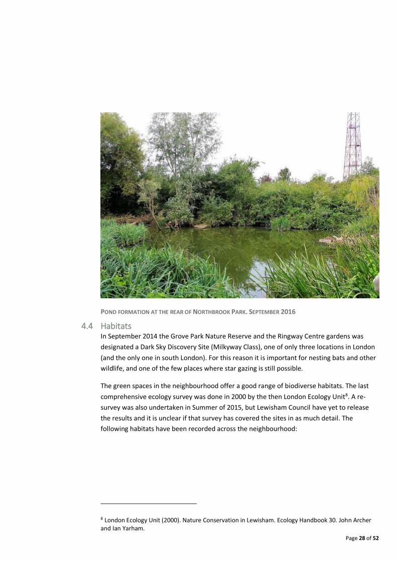
POND FORMATION AT THE REAR OF NORTHBROOK PARK. SEPTEMBER 2016
4.4 Habitats In September 2014 the Grove Park Nature Reserve and the Ringway Centre gardens was
designated a Dark Sky Discovery Site (Milkyway Class), one of only three locations in London
(and the only one in south London). For this reason it is important for nesting bats and other
wildlife, and one of the few places where star gazing is still possible.
The green spaces in the neighbourhood offer a good range of biodiverse habitats. The last
comprehensive ecology survey was done in 2000 by the then London Ecology Unit8. A re-
survey was also undertaken in Summer of 2015, but Lewisham Council have yet to release
the results and it is unclear if that survey has covered the sites in as much detail. The
following habitats have been recorded across the neighbourhood:
8 London Ecology Unit (2000). Nature Conservation in Lewisham. Ecology Handbook 30. John Archer and Ian Yarham.
Page 29 of 52
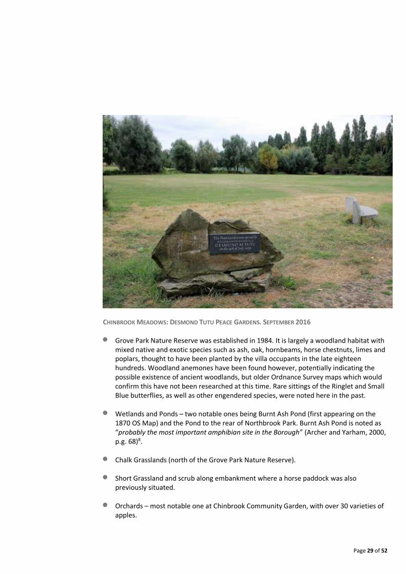
CHINBROOK MEADOWS: DESMOND TUTU PEACE GARDENS. SEPTEMBER 2016
Grove Park Nature Reserve was established in 1984. It is largely a woodland habitat with mixed native and exotic species such as ash, oak, hornbeams, horse chestnuts, limes and poplars, thought to have been planted by the villa occupants in the late eighteen hundreds. Woodland anemones have been found however, potentially indicating the possible existence of ancient woodlands, but older Ordnance Survey maps which would confirm this have not been researched at this time. Rare sittings of the Ringlet and Small Blue butterflies, as well as other engendered species, were noted here in the past.
Wetlands and Ponds – two notable ones being Burnt Ash Pond (first appearing on the 1870 OS Map) and the Pond to the rear of Northbrook Park. Burnt Ash Pond is noted as “probably the most important amphibian site in the Borough” (Archer and Yarham, 2000, p.g. 68)8.
Chalk Grasslands (north of the Grove Park Nature Reserve).
Short Grassland and scrub along embankment where a horse paddock was also previously situated.
Orchards – most notable one at Chinbrook Community Garden, with over 30 varieties of apples.
Page 30 of 52
Willow Woodland at land north of stables, which were recently cut down by the new land owner, a day before the TPO on the site was issued.
Sycamore Woodland at Amblecote Road Woods.
FIGURE 3: TOPOGRAPHY OF GROVE PARK
Page 31 of 52
5 Built Heritage
“It has been most truly said, that these old buildings do not belong to us only; that they have belonged to our forefathers, and they will belong to our descendants unless we play them false. They are not in any sense our property, to do as we like with. We are only trustees for those that come after us. So I say nothing but absolute necessity can excuse the destruction of these buildings; and I say, further, that such a necessity has never yet existed in our time.”
William Morris, founder of the Arts and Crafts movement, 1889
It seems that the influential architect Richard Norman Shaw was responsible for introducing
his former pupil and employee Ernest Newton to the Earl of Northbrook. Northbrook would
have been one of Newton’s first independent clients.
The choice of Ernest Newton as the preferred architect for the growing suburb meant that it
was destined to be more than a run of the mill speculative development on the edge of
London; his talents and influences were from the outset guided by the very best of late
nineteenth century architectural practice. When Newton began his career in June 1873 as a
pupil in the office of the celebrated architect, Richard Norman Shaw, the practice was
enjoying considerable acclaim. At a time when the dominant architectural fashion for the
gothic revival was on the wane, Norman Shaw, in his New Zealand Chambers (1871)
introduced into popular public taste a new style which drew not from the design vocabulary
of the medieval period but from a distinctly English palette of red brick, clear glass, white
painted woodwork and red roof tiles. Just as the Gothic revival had been led by the polemics
of Pugin, this new style had a powerful lead advocate in William Morris and his firm Morris &
Co. The Red House, designed for him in 1859 by Philip Webb, five miles from Grove Park at
Bexleyheath, had been the first manifestation of this new ‘domestic revival’ style. Where
Webb and Butterfield led in the 1850s, Norman Shaw, G. F. Bodley and W. E. Nesfield
followed in the domestic work of the 1860s, and more attention grabbing public projects
emerged in the 1870s. Reducing the ‘Domestic Revival’, or - as it was known at the time – its
‘Queen Anne’ style to simple description is always a challenge, but its founding tenets were a
reaction to the moralising North European Gothic and the selection of a palette of materials
and details that, instead, reflected predominantly English details in an ‘aesthetic’
arrangement that tended towards the picturesque. The London Board Schools (built from
1872 to the early 1900s) were almost invariably designed within the movement, and
represent its most tangible legacy today, along with the prototype ‘aesthetic’ suburb of
Bedford Park (Turnham Green, from 1876).
Page 32 of 52
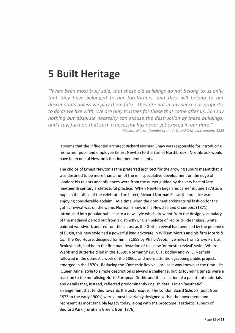
THE BARING HALL HOTEL AS DESIGNED BY ERNEST NEWTON. SOURCE: THE BUILDING NEWS PUBLISHED IN
1882
Thus for his three years pupillage and three further years, Ernest Newton had the benefit of
working for one of the most popular and influential architects of the day. It is no surprise
that his work in his own practice from 1879 should reflect these cosmopolitan and
fashionable beginnings.
The son of an estate manager from Bickley, he took the fashion for bright, tile hung, brick
villas in particular, and adapted the style for use in the burgeoning suburbs of Grove Park,
Bromley, Bickley and Chislehurst. While his late career would be distinguished by the design
of large country houses, his reputation was established by these smaller houses for the
middle classes, as well as churches, shops and public houses that completed these new
communities. Close by, his St. Swithin’s Church, Hither Green (1892), Martin’s Bank and
shops in Bromley High Street (1898) remain local landmarks.
Page 33 of 52
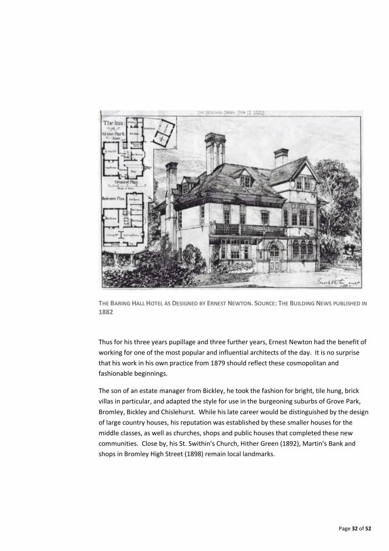
FORMER GROVE PARK HOSPITAL NOW CONVERTED TO HOUSING, KEEPING THE ORIGINAL FAÇADE, BUT
DEMOLISHING THE REAR. SEPTEMBER 2016
But at Grove Park the opportunity to style an entire community for a single dominant client
presented itself early in his career. According to Girouard in ‘Sweetness & Light’, the best
historical account of the Queen Anne movement: “Early work by Ernest Newton could be
seen in abundance at Grove Park, an estate near Eltham belonging to the Earl of Northbrook,
where from 1879 onwards he designed a public house and a good deal of housing. The result
must have been the prettiest and most accomplished of the estates built under the influence
of Bedford Park in the 1880s, but little of it has survived”, (Girouad, 1977).
The pub is of course the Baring Hall Hotel (1882), and its survival is now hopefully assured,
having been designated as an Asset of Community Value, with Article 4 direction. Published
images of the time exist of at least two of the houses, all of which would have had unique
designs, and other surviving houses may await attribution to Newton. Newton went on to
be one of the founders of the Art Workers Guild and was, from the date of his very first book
‘Sketches for Country Residences’ (1882), one of the principal proponents of the rediscovery
of the English vernacular in architectural style. That he found his ‘voice’ in Grove Park and
the Baring Hall Hotel while in his 20s represents a significant milestone in art history.
Page 34 of 52
The Lewisham Character Study9 defined the dominant typologies in Grove Park as follows:
Suburban Housing: with “reasonably cohesive feel, and building line. Buildings are most
likely to be two storeys although three storey examples can be found. New development
in these areas should respond to this context. Development of new separate dwellings in
the rear gardens of this urban typology will not generally be acceptable due to the
difficulty of maintaining the established character of these areas”.
Suburban Complex Block: “These represent the trend for cul-de-sacs in later twentieth
century development. They feature low densities of housing and have generally poor
permeability and legibility. Plot configurations vary enormously in this typology as most
are grouped in an irregular way around a curving street layout. A common feature is that
houses in this form rarely feature gardens deeper than 10 metres creating a minimum
back-to-back relationship with a basic level of privacy. Private rear gardens in this urban
typology will therefore not be suitable for development. New development in amenity
and non-garden areas within this typology should not seek to replicate this layout but
should aim to re-introduce the positive elements of the urban terrace typology in
ensuring clear legible routes, and well defined private and public spaces”.
9 Lewisham Borough Wide Character Study. October 2010. Urban Practitioners - https://www.lewisham.gov.uk/myservices/planning/policy/Documents/LewishamBoroughWideCharacterStudyP1.pdf.

Page 35 of 52
FIGURE 4: DWELLING MODAL AGE MAP
Source: https://maps.cdrc.ac.uk/#/metrics/dwellingage/default/BTTTTTT/14/0.0216/51.4417/. Further information on dataset: http://oobrien.com/2015/12/building-ages/
Page 36 of 52
6 Industrial & Economic Heritage
Dairy farming and plant nurseries are associated with Grove Park’s historic economy. Burnt
Ash Farm at the northern end of Baring Road eventually became a milk distribution depot of
United Dairies/Unigate. It occupied number 2 Baring Road until it ceased business in
December 2000 and was soon after demolished10 to make way for an apartment
development. An archaeological dig of the United Dairies site revealed artefacts dating back
to twelfth to fourteenth centuries. The report which details the dig can be found at
Archaeological Data Services website11.
Sports grounds and private housing consumed Grove Park’s remaining dairy pasture and
plant nurseries in the 1930s, although a pig and poultry farm was subsequently established
for wartime purposes. This survived until the construction of the Marbrook Estate in the
1960s, which followed a number of smaller infill projects designed to address the post-war
housing shortage. There are also no signs left of the nurseries which were once incorporated
within Chinbrook Meadows.
Grove Park played a significant role in both world wars. Napier House was completed in 1938
to house 600 men in two anti-aircraft searchlight units, the 329th and 330th, in the City of
London Battalion. The biggest Territorial Army building in the country, it was opened just
before the Second World War in 1939 by the Lord Mayor of London who was guided to
Grove Park by 16 searchlights lighting up the night sky. In June 1940, the 330th was the first
searchlight company to shoot down an enemy aircraft on British soil.
Today there are no designated sites for local employment in Grove Park, with only limited
retail uses in the neighbourhood centre and other isolated shopping parades scattered
throughout the neighbourhood, as well as a scattering of light industrial sites and office units
(as part of retail parades).
10 Planning Committee Notes, May 24 2004 - http://councilmeetings.lewisham.gov.uk/Data/Planning%20Committee%20A/20040520/Agenda/Former%20United%20Dairies%20Depot,%202%20Baring%20Road%20SE12.pdf 11 United Dairies Archaeological Dig. http://archaeologydataservice.ac.uk/archiveDS/archiveDownload?t=arch-414-1/dissemination/pdf/aocarcha1-112267_2.pdf.
Page 37 of 52
7 Cultural & Social Heritage
7.1 Attracting the Aesthetic Movement Whether just following architectural fashion or a real attempt to style a south London rival to
Bedford Park, the efforts of Lord Northbrook and John Pound did attract, if not just
aesthetes, certainly its share of liberals and free-thinkers. Of these the most celebrated
today is Edith Nesbit, already a resident of Lewisham and Lee, who was, through her growing
literary reputation, able to afford a move to Grove Park in 1894. The house, Three Gables,
designed by Newton in 1884, marked a change from 2 Birch Grove (near Burnt Ash Hill),
where she had lived from September 1889. In Birch Grove, she and her husband Hubert
cultivated a circle of acquaintances based on their leading roles in the Fabian Society; held a
regular debating circle, the Lewisham Literary Society; and organised large scale parties, with
elaborate arrangements of catering and fancy dress, for the poor children at Deptford Board
School.
The Blands’ circle was wide and radical, and guests at their homes in south-east London
included George Bernard Shaw; artist Hugh Bellingham Smith; artist and writer Laurence
Housman (brother of AE Housman); Dr Wallis Budge, Keeper of Egyptian and Assyrian
Antiquities at the British Museum; and writer Marshall Steele. Poet Richard Le Gallienne was
Edith’s lover in the early 1890s. A trio of writers - Oswald Barron, a journalist and historian;
Olindo Malagodi, a London Correspondent of Tribuna; and Edgar Jepson, a novelist - were so
bewitched by Edith that they would rent a house nearby and came to be styled the ‘Grove
Park Bachelors’. The heady mix of sexual, philosophical and aesthetic liberalities represented
by this circle (both Blands pursued other partners) certainly scandalised the neighbours in
Burnt Ash Hill; as did the fact that Edith allowed her children to run over the neighbourhood
barefooted.
Grove Park, whilst not entirely free from the potential for ruffled sensibilities, would have
represented certain freedoms of thought and movement in physical form. Three Gables was
in the best fashion of “Queen Anne” free styling; beneath the hipped roof, tall brick
chimneys and titular gables (two half timbered, the central one pargeted), the fenestration
was irregular and deep bay windows were thrown out from the principal rooms into the
generous gardens. When built, it stood amongst fields (though the railway had arrived at
the bottom of the garden) and the grounds were big enough to play badminton, which the
family took up enthusiastically. Edith passionately wanted sufficient space to provide
enough freedom for her children. As a result they roamed the new neighbourhood
unfettered, which would backfire with a minor scandal when they were caught begging from
commuters at Grove Park station in order to augment their pocket money.
Page 38 of 52
Meanwhile Edith’s unconventionality was not compromising her growing reputation. Since
her marriage, she had augmented the family income through writing. In 1896-7 she was
writing children’s stories for Girl’s Own Paper and other titles, and in 1898 the Bastable
Family stories began to appear in the Pall Mall Magazine. Thus the Three Gables can be seen
as a cradle of the stories, such as ‘The Treasure Seekers’, which would make her reputation.
Perhaps inevitably, Edith would find another house that more perfectly matched her
profound romanticism, as well as her generosity and hospitality. This was not far away at
Well Hall, Kent, which Edith discovered in 1898 and for which she quitted her lease at Grove
Park in May 1899 before it had ended. Here she would have a famous salon, restore the old
house and garden, and live for 20 tumultuous years as a leading literary and cultural figure,
courting amongst others HG Wells.
Edgar Jepson and the others also left Grove Park about the same time (1899). In his
Memoirs of an Edwardian and Neo Georgian he fondly recalls the Blands’ time there, and the
power of the circle they drew around them during their time at Grove Park:
“It was a house of youth: they seemed to have no use for the old: they seldom encouraged
the middle aged and never the dull. Wherever they went, their own circle went with them; at
the Three Gables, at Well Hall, and at their house in Dymchurch, in which they spent most of
their summer; though civil to their neighbours, they were never intimate with them; they
believed that the native residents would bore them by a lack of understanding. The native
residents did not understand them; but how they did gossip about them! The Blands’
aloofness was the right attitude for people interested in ideas to assume when living in
suburbs” (Jepson, 1937, p.24).
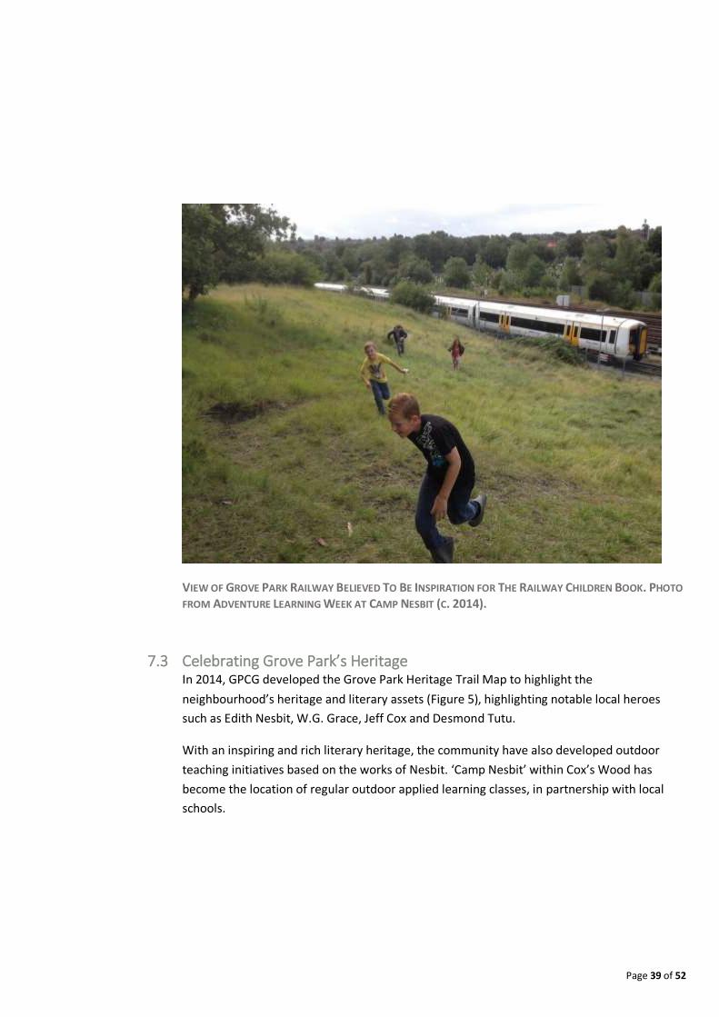
7.2 Literature The Grove Park railway is believed to be the inspiration for Edith Nesbit’s ‘The Railway
Children’ story. Oswald Barron is also credited for having collaborated with Edith Nesbit for
the plot of The Railway Children, among other works. While residing in Grove Park in his
early twenties he became romantically involved with Nesbit (1858–1924). Their joint book
‘The Butler in Bohemia’ (1894) was dedicated to their mutual friend Rudyard Kipling. This
may have been a possible future inspiration for naming the Kipling Telephone Exchange on
Grove Park Road. Barron's deep attachment to Nesbit ceased in 1899 when he married Hilda
Leonora Florence Sanders, a member of an old Northamptonshire family, but his influence
outlasted his departure and he is widely credited with having provided the plot for The
Railway Children while in Grove Park – the book finally appeared in 1906 (Campbell-Kease,
2004).
Page 39 of 52
VIEW OF GROVE PARK RAILWAY BELIEVED TO BE INSPIRATION FOR THE RAILWAY CHILDREN BOOK. PHOTO
FROM ADVENTURE LEARNING WEEK AT CAMP NESBIT (C. 2014).
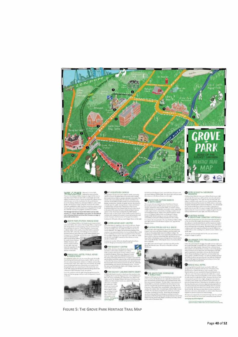
7.3 Celebrating Grove Park’s Heritage In 2014, GPCG developed the Grove Park Heritage Trail Map to highlight the
neighbourhood’s heritage and literary assets (Figure 5), highlighting notable local heroes
such as Edith Nesbit, W.G. Grace, Jeff Cox and Desmond Tutu.
With an inspiring and rich literary heritage, the community have also developed outdoor
teaching initiatives based on the works of Nesbit. ‘Camp Nesbit’ within Cox’s Wood has
become the location of regular outdoor applied learning classes, in partnership with local
schools.
Page 40 of 52
FIGURE 5: THE GROVE PARK HERITAGE TRAIL MAP

Page 41 of 52
CAMP NESBIT OUTDOOR LEARNING CLASSES (C. 2014)

Page 42 of 52
7.4 Sporting Connections The Community Centre on Lion’s Close was named after the famous cricket player W.G.
Grace as a result of his associated last games played in Grove Park. The local historian John
King covers the story. In Grove Park there were at that period three cricket clubs – St.
Augustine, Fairfield and Grove Park. The church’s club had been formed in 1910 while the
Grove Park Club had been formed in 1913. The grounds were on farmland in Marvels Lane
near the Quaggy. It was on 6 June 1914 that the Eltham Club received the Grove Park team
at its Mottingham ground. The match was a draw. Grace’s penultimate match was on 25 July
1914 against the Grove Park Club on the latter’s ground. It was not his last match but it was
the last one in which he played an active part. Grace made 69 not out, which was the highest
score of the match - not bad for the oldest player at 66! Grace died on 23 October 1915, with
his funeral being held at Beckenham Cemetery in Elmers End.
Page 43 of 52
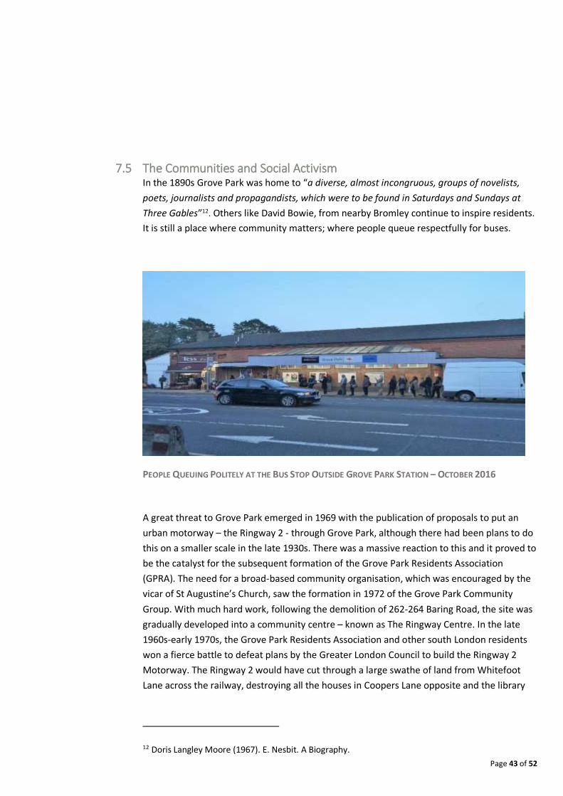
7.5 The Communities and Social Activism In the 1890s Grove Park was home to “a diverse, almost incongruous, groups of novelists,
poets, journalists and propagandists, which were to be found in Saturdays and Sundays at
Three Gables”12. Others like David Bowie, from nearby Bromley continue to inspire residents.
It is still a place where community matters; where people queue respectfully for buses.
PEOPLE QUEUING POLITELY AT THE BUS STOP OUTSIDE GROVE PARK STATION – OCTOBER 2016
A great threat to Grove Park emerged in 1969 with the publication of proposals to put an
urban motorway – the Ringway 2 - through Grove Park, although there had been plans to do
this on a smaller scale in the late 1930s. There was a massive reaction to this and it proved to
be the catalyst for the subsequent formation of the Grove Park Residents Association
(GPRA). The need for a broad-based community organisation, which was encouraged by the
vicar of St Augustine’s Church, saw the formation in 1972 of the Grove Park Community
Group. With much hard work, following the demolition of 262-264 Baring Road, the site was
gradually developed into a community centre – known as The Ringway Centre. In the late
1960s-early 1970s, the Grove Park Residents Association and other south London residents
won a fierce battle to defeat plans by the Greater London Council to build the Ringway 2
Motorway. The Ringway 2 would have cut through a large swathe of land from Whitefoot
Lane across the railway, destroying all the houses in Coopers Lane opposite and the library
12 Doris Langley Moore (1967). E. Nesbit. A Biography.
Page 44 of 52
and green spaces as far as the Dutch House pub on the A20. Two houses that stood here
were demolished.
THE
CAMPAIGNING FOR THE REOPENING OF GPYC
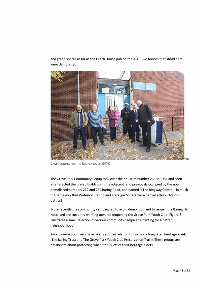
The Grove Park Community Group took over the house at number 268 in 1981 and soon
after erected the prefab buildings in the adjacent land previously occupied by the now
demolished numbers 262 and 264 Baring Road, and named it The Ringway Centre – in much
the same way that Waterloo Station and Trafalgar Square were named after victorious
battles!
More recently the community campaigned to avoid demolition and to reopen the Baring Hall
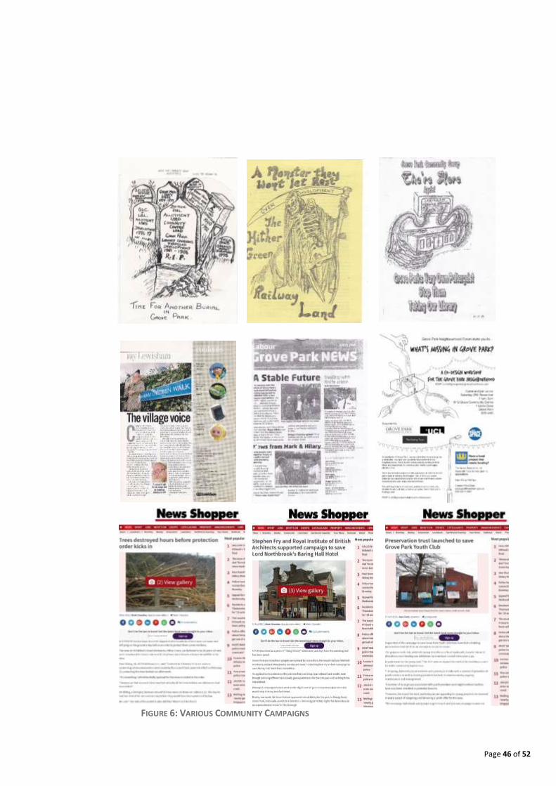
Hotel and are currently working towards reopening the Grove Park Youth Club. Figure 6
illustrates a small selection of various community campaigns, fighting for a better
neighbourhood.
Two preservation trusts have been set up in relation to two non-designated heritage assets
(The Baring Trust and The Grove Park Youth Club Preservation Trust). These groups are
passionate about protecting what little is left of their heritage assets.

Page 45 of 52
Page 46 of 52
FIGURE 6: VARIOUS COMMUNITY CAMPAIGNS
Page 47 of 52
8 Policy Context
The detailed planning policy context is further elaborated in Chapter 5 – Basic Conditions
Statement. Figure 7 is an extract from the Lewisham Local Plan showing the planning
designations / site allocations in Grove Park. This section outlines the key Local Plan policies
which apply directly to Grove Park.
8.1 Area of Stability and Management Change Grove Park is classed by the Lewisham Development Framework (Local Plan)13 as an “Area of
Stability and Managed Change” – forming Spatial Strategy Policy 5. It defines the objective
for Policy 5 as delivering “quality living environments supported by a network of local
services and facilities”. This is supported by a number of sub-statements that seek to:
“ensure that any new development protects or enhances; ensure the retention and
protection of shopping areas that contribute to local day-to-day retail needs and
employment; seek improvements to the walking and cycling environment, in order to
improve access to local services and public transport provision”.
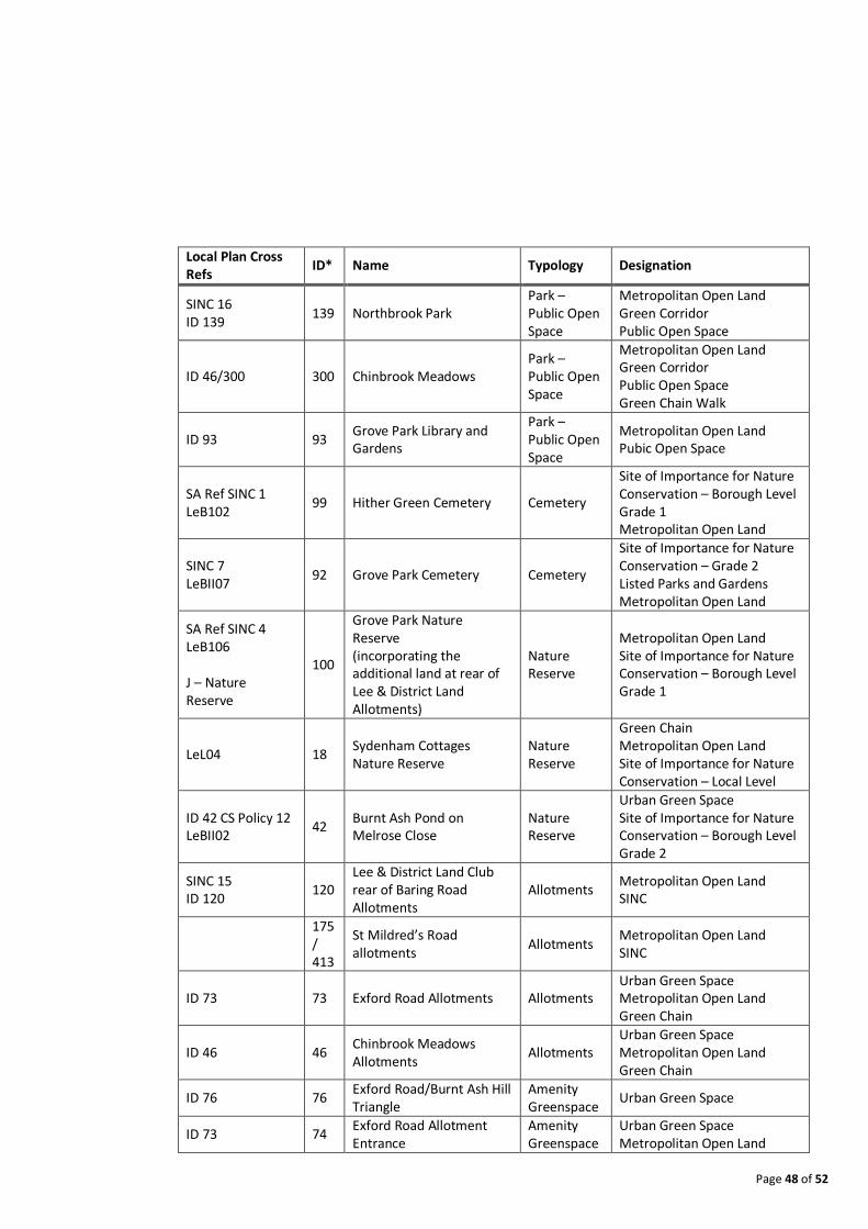
8.2 Open Space Grove Park has a number of existing Open Space Site Allocations (as detailed in Table 2
below) which relate to Core Strategy Policy 12 – Open Space and Environmental Assets and
Core Strategy Objective 7 also applying which states: “the important environmental,
ecological and biodiversity features of Lewisham will be protected and capitalised to
promote health and well-being by: a. protecting all open space including Metropolitan
Open Land; b. protecting Sites of Importance for Nature Conservation and supporting and
promoting local biodiversity; c. requiring green roofs and walls where appropriate; d.
implementing the Street Tree Programme; e. improving the quality of, and safeguarding
access to, all public open space, providing accessible and varied opportunities for health,
leisure and recreational activities including the South East London Green Chain Walk, the
Green Grid, the Waterlink Way and river and waterways network, and the Thames Path”.
13 Local Development Framework - http://www.lewisham.gov.uk/myservices/planning/policy/LDF/Pages/default.aspx
Page 48 of 52
Local Plan Cross Refs
ID* Name Typology Designation
SINC 16 ID 139
139 Northbrook Park Park – Public Open Space
Metropolitan Open Land Green Corridor Public Open Space
ID 46/300 300 Chinbrook Meadows Park – Public Open Space
Metropolitan Open Land Green Corridor Public Open Space Green Chain Walk
ID 93 93 Grove Park Library and Gardens
Park – Public Open Space
Metropolitan Open Land Pubic Open Space
SA Ref SINC 1 LeB102
99 Hither Green Cemetery Cemetery
Site of Importance for Nature Conservation – Borough Level Grade 1 Metropolitan Open Land
SINC 7 LeBII07
92 Grove Park Cemetery Cemetery
Site of Importance for Nature Conservation – Grade 2 Listed Parks and Gardens Metropolitan Open Land
SA Ref SINC 4 LeB106 J – Nature Reserve
100
Grove Park Nature Reserve (incorporating the additional land at rear of Lee & District Land Allotments)
Nature Reserve
Metropolitan Open Land Site of Importance for Nature Conservation – Borough Level Grade 1
LeL04 18 Sydenham Cottages Nature Reserve
Nature Reserve
Green Chain Metropolitan Open Land Site of Importance for Nature Conservation – Local Level
ID 42 CS Policy 12 LeBII02
42 Burnt Ash Pond on Melrose Close
Nature Reserve
Urban Green Space Site of Importance for Nature Conservation – Borough Level Grade 2
SINC 15 ID 120
120 Lee & District Land Club rear of Baring Road Allotments
Allotments Metropolitan Open Land SINC
175 / 413
St Mildred’s Road allotments
Allotments Metropolitan Open Land SINC
ID 73 73 Exford Road Allotments Allotments Urban Green Space Metropolitan Open Land Green Chain
ID 46 46 Chinbrook Meadows Allotments
Allotments Urban Green Space Metropolitan Open Land Green Chain
ID 76 76 Exford Road/Burnt Ash Hill Triangle
Amenity Greenspace
Urban Green Space
ID 73 74 Exford Road Allotment Entrance
Amenity Greenspace
Urban Green Space Metropolitan Open Land
Page 49 of 52
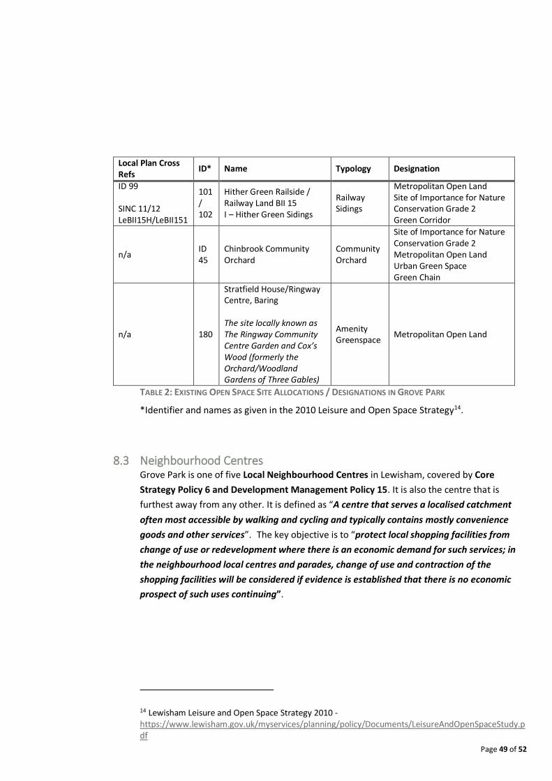
Local Plan Cross Refs
ID* Name Typology Designation
ID 99 SINC 11/12 LeBII15H/LeBII151
101 / 102
Hither Green Railside / Railway Land BII 15 I – Hither Green Sidings
Railway Sidings
Metropolitan Open Land Site of Importance for Nature Conservation Grade 2 Green Corridor
n/a ID 45
Chinbrook Community Orchard
Community Orchard
Site of Importance for Nature Conservation Grade 2 Metropolitan Open Land Urban Green Space Green Chain
n/a 180
Stratfield House/Ringway Centre, Baring The site locally known as The Ringway Community Centre Garden and Cox’s Wood (formerly the Orchard/Woodland Gardens of Three Gables)
Amenity Greenspace
Metropolitan Open Land
TABLE 2: EXISTING OPEN SPACE SITE ALLOCATIONS / DESIGNATIONS IN GROVE PARK
*Identifier and names as given in the 2010 Leisure and Open Space Strategy14.
8.3 Neighbourhood Centres Grove Park is one of five Local Neighbourhood Centres in Lewisham, covered by Core
Strategy Policy 6 and Development Management Policy 15. It is also the centre that is
furthest away from any other. It is defined as “A centre that serves a localised catchment
often most accessible by walking and cycling and typically contains mostly convenience
goods and other services”. The key objective is to “protect local shopping facilities from
change of use or redevelopment where there is an economic demand for such services; in
the neighbourhood local centres and parades, change of use and contraction of the
shopping facilities will be considered if evidence is established that there is no economic
prospect of such uses continuing”.
14 Lewisham Leisure and Open Space Strategy 2010 - https://www.lewisham.gov.uk/myservices/planning/policy/Documents/LeisureAndOpenSpaceStudy.pdf

Page 50 of 52
8.4 Community Facilities The Core Strategy map (see Figure 7)15 highlights one Community Centre in Grove Park (The
Ringway Centre), covered by Core Strategy 19 which ensures “no net loss of facilities; their
accessibility and that a safe and secure environment is created and maintained.”
8.5 Housing According to the Annual Monitoring Report 2015-1616, no sites have been allocated for
housing development in Grove Park. The site of the former dairies, marked as Site Allocation
(SA39) has since been delivered, now being an apartment development.
15 Online interactive version of the Lewisham Local Plan Policies Map - http://www.cartogold.co.uk/lewisham/map.htm 16 Annual Monitoring Report 2015-16 - http://www.lewisham.gov.uk/myservices/planning/policy/LDF/Documents/AnnualMonitoringReport2015-16.PDF

Page 51 of 52
FIGURE 7: LEWISHAM LOCAL PLAN POLICIES MAP. DECEMBER 2015 VERSION

GROVE PARK NEIGHBOURHOOD FORUM EMAIL: [email protected] WEB: http://www.groveparkneighbourhoodforum.com/ TWITTER: https://twitter.com/groveparknforum