chapter 1 introduction - amazon...
TRANSCRIPT
Chapter 1 IntroductionNovember 2013
GHD | Report for Adani Mining Pty Ltd - North Galilee Basin Rail, 41/26457 | i
Table of contents
1. Introduction................................................................................................................................. 1-1
1.1 Project overview ............................................................................................................... 1-1
1.2 Project proponent ............................................................................................................. 1-3
1.3 Project rationale ............................................................................................................... 1-3
1.4 Relationship to other projects .......................................................................................... 1-4
1.5 Project alternatives .......................................................................................................... 1-5
1.5.1 Preferred option ..................................................................................................... 1-5 1.5.2 Co-location and co-use .......................................................................................... 1-7 1.5.3 Do nothing .............................................................................................................. 1-8
1.6 The environmental impact assessment process ........................................................... 1-10
1.6.1 Overview .............................................................................................................. 1-10 1.6.2 EIS objectives ...................................................................................................... 1-10 1.6.3 EIS structure ........................................................................................................ 1-10 1.6.4 Environmental impact assessment methodology ................................................ 1-11 1.6.5 Cumulative Impacts ............................................................................................. 1-13 1.6.6 Ecologically sustainable development ................................................................. 1-13
1.7 Community and stakeholder consultation ...................................................................... 1-14
1.7.1 Consultation methodology ................................................................................... 1-14 1.7.2 Draft Terms of Reference consultation ................................................................ 1-15 1.7.3 Commonwealth Government ............................................................................... 1-15 1.7.4 State Government ................................................................................................ 1-16 1.7.5 Council briefings and meetings ............................................................................ 1-17 1.7.6 Community information sessions ......................................................................... 1-17 1.7.7 Other consultation ................................................................................................ 1-18 1.7.8 Public exhibition of the EIS .................................................................................. 1-18 1.7.9 How to make a submission .................................................................................. 1-18 1.7.10 Future consultation activities .............................................................................. 1-19
Table index
Table 1-1 Summary of agency briefings and meetings ...................................................................... 1-16
Table 1-2 Council briefings and meetings .......................................................................................... 1-17
Figure index
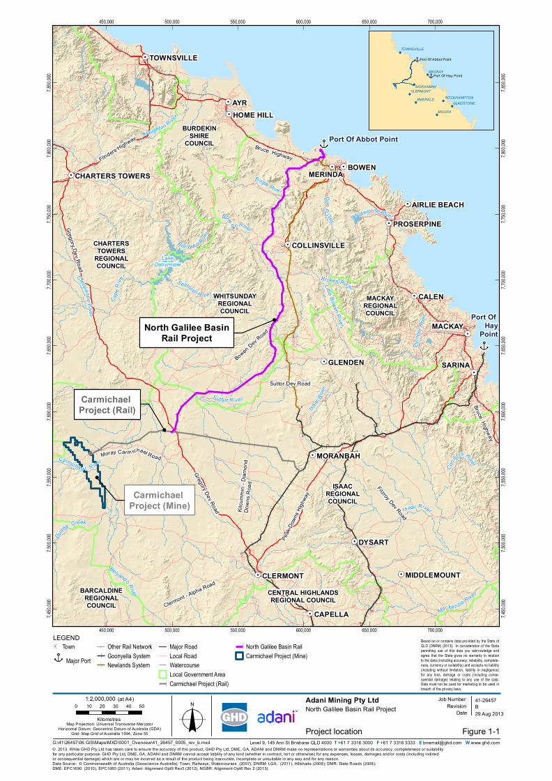
Figure 1-1 Project location ................................................................................................................... 1-2
Figure 1-2 Corridor selection study ...................................................................................................... 1-9
GHD | Report for Adani Mining Pty Ltd - North Galilee Basin Rail, 41/26457 | 1-1
1. Introduction
1.1 Project overview
Adani Mining Pty Ltd (Adani) proposes the construction and operation of the North Galilee Basin
Rail Project (NGBR Project), a multiuser, standard gauge, greenfield rail line that will transport
coal from mines in the northern Galilee Basin to the Port of Abbot Point. The NGBR Project is
approximately 300 km in length and connects the proposed Carmichael Coal Mine and Rail
Project’s east-west rail corridor, approximately 70 km east of the proposed Carmichael Coal
Mine in the vicinity of Mistake Creek, with supporting infrastructure at the Port of Abbot Point
(refer Figure 1-1). The NGBR Project will have an operational capacity of up to 100 million
tonnes per annum (mtpa) of coal product expected to be sourced from both Adani and third-
party mines in the northern Galilee Basin. Key features of the NGBR Project include:
Approximately 300 km of standard gauge, bi-directional rail track located within a nominal
100 m wide rail corridor (the final rail corridor)
A rail maintenance access road running parallel to the rail track for approximately 300 km
and wholly within the final rail corridor
Seven passing loops, each 4.3 km in length
Signalling infrastructure
Approximately 4.5 km of fill greater than 15 m in depth (11 locations) and approximately
3.4 km of cut greater than 15 m in depth (nine locations)
At-grade and grade-separated road, rail, stock and occupational crossings
Bridge and culvert structures at major waterways and drainage lines, and various other
longitudinal and cross drainage structures
A rolling stock maintenance facility near the Port of Abbot Point including provisioning
line, train maintenance line, wagon and locomotive service sheds, wash bay and queuing
line
Five temporary accommodation camps for construction workers
A temporary construction depot at the southern end of NGBR Project
Temporary construction yards, concrete batching plants, bridge and track laydown areas
and heavy vehicle turning circles.
During construction, quarries and borrow pits within acceptable haulage distances will be
required to provide a cost effective source of fill, gravel, aggregate and ballast. The number and
location of borrow pits and quarries will be investigated further during detailed design and each
may require screening and crushing plants to process material.
Further detail regarding the description of the NGBR Project, including a detailed overview of
construction and operation, is provided in Volume 1 Chapter 2 Project description.
Carmichael Project (Rail)
Carmichael Project (Mine)
North Galilee BasinRail Project
Bow
e n RiverDonR
iver
Port Of Hay
Point
Port Of Abbot Point
ISAACREGIONALCOUNCIL
CHARTERSTOWERS
REGIONALCOUNCIL
BURDEKINSHIRE
COUNCIL
WHITSUNDAYREGIONALCOUNCIL
BARCALDINEREGIONALCOUNCIL
CENTRAL HIGHLANDSREGIONAL COUNCIL
MACKAYREGIONALCOUNCIL
Suttor Dev Road
Bowen Dev Road
Bruce Highway
Gregory Dev Road
Fitzroy Dev Road
Bruce Highway
Peak
Down
s High
way
Gregory Dev Road
Flinders Highway
Clermont - Alpha Road
Kilcu
mmin
- Diam
ond
Down
s Roa
d
Moray Car m ichael Road
LakeDalryrmple
Dunda Creek
Carmicha e l R iver
AYR
BOWEN
CALEN
DYSART
SARINA
MACKAY
CAPELLA
GLENDEN
CLERMONT
MORANBAH
HOME HILL
TOWNSVILLE
PROSERPINE
MIDDLEMOUNT
COLLINSVILLE
AIRLIE BEACH
CHARTERS TOWERS
Isaac River
Bur d ekin River
Bogie River
Su ttor Ri ve r
Broken River
Haughton RiverCa
peRi
ve r
Belyando River
Sellheim R ive r
Conno
rs River
Campaspe Ri v er
Pione
erRiv
er
Macke nzie River
Little Bowen River
Proserpine River
Isaac
River
450,000
450,000
500,000
500,000
550,000
550,000
600,000
600,000
650,000
650,000
700,000
700,000
7,450,
000
7,450,
000
7,500,
000
7,500,
000
7,550,
000
7,550,
000
7,600,
000
7,600,
000
7,650,
000
7,650,
000
7,700,
000
7,700,
000
7,750,
000
7,750,
000
7,800,
000
7,800,
000
7,850,
000
7,850,
000
Figure 1-1
LEGEND
© 2013. While GHD Pty Ltd has taken care to ensure the accuracy of this product, GHD Pty Ltd, DME, GA, ADANI and DNRM make no representations or warranties about its accuracy, completeness or suitabilityfor any particular purpose. GHD Pty Ltd, DME, GA, ADANI and DNRM cannot accept liability of any kind (whether in contract, tort or otherwise) for any expenses, losses, damages and/or costs (including indirector consequential damage) which are or may be incurred as a result of the product being inaccurate, incomplete or unsuitable in any way and for any reason.
Adani Mining Pty LtdNorth Galilee Basin Rail Project
Project location
Data Source: © Commonwealth of Australia (Geoscience Australia): Town, Railways, Watercourses (2007); DNRM: LGA, (2011), Hillshade (2009); DMR: State Roads (2008); DME: EPC1690 (2010), EPC1080 (2011); Adani: Alignment Opt9 Rev3 (2012), NGBR: Alignment Opt6 Rev 2 (2013).
Level 9, 145 Ann St Brisbane QLD 4000 T +61 7 3316 3000 F +61 7 3316 3333 E [email protected] W www.ghd.com
B41-26457
29 Aug 2013Map Projection: Universal Transverse Mercator
Horizontal Datum: Geocentric Datum of Australia (GDA)Grid: Map Grid of Australia 1994, Zone 55
0 10 20 30 40 50
Kilometres
Based on or contains data provided by the State ofQLD (DNRM) [2013]. In consideration of the Statepermitting use of this data you acknowledge andagree that the State gives no warranty in relationto the data (including accuracy, reliability, complete-ness, currency or suitability) and accepts no liability(including without limitation, liability in negligence)for any loss, damage or costs (including conse-quential damage) relating to any use of the data.Data must not be used for marketing or be used inbreach of the privacy laws.
Job NumberRevision
Date
TownMajor Port
Other Rail NetworkGoonyella SystemNewlands System
Major RoadLocal RoadWatercourseLocal Government AreaCarmichael Project (Rail)
North Galilee Basin RailCarmichael Project (Mine)
EMERALD
MOURA
TOWNSVILLE
ROCKHAMPTONGLADSTONE
CLERMONT
MACKAY
MORANBAH
Port Of Hay Point
Port Of Abbot Point
1:2,000,000 (at A4)
G:\41\26457\06 GIS\Maps\MXD\0001_Overview\41_26457_0005_rev_b.mxd
MERINDA
GHD | Report for Adani Mining Pty Ltd - North Galilee Basin Rail, 41/26457 | 1-3
1.2 Project proponent
Adani Mining Pty Ltd (Adani) is the proponent for the NGBR Project. Adani is a subsidiary of
Adani Enterprises Ltd, and forms part of the broader Adani Group of companies based in
Ahmedabad, India.
Adani is a registered Australian company with corporate governance and reporting obligations
under Australian Law, distinct from the management and obligations of other Adani Group
subsidiaries in other jurisdictions.
Adani Abbot Point Terminal Pty Ltd, also an Australian subsidiary of Adani Enterprises Limited,
has purchased the lease of Abbot Point Coal Terminal 1 and is proposing to develop Abbot
Point Coal Terminal 0 as part of their overall programme for exportation of coal.
Adani has not been subject to any proceedings under an Australian Commonwealth, State or
Territory law for the protection of the environment or the conservation and sustainable use of
natural resources. Under both State and Federal laws, Adani is required to obtain all relevant
approvals, including all necessary environmental approvals, prior to the commencement of a
project.
Internationally, any representations to statutory authorities or proceedings initiated and /or
currently before the courts are under judicial consideration.
Adani has a proven record of obtaining and complying with all necessary approvals for its
projects including the Environmental Authority for the Carmichael Coal Mine ongoing exploration
program.
Adani is committed to complying with all required approvals for the NGBR Project.
1.3 Project rationale
There are a number of key State and Federal government policies that guide and inform the
development of Queensland’s abundant coal resources. The Coal Plan 2030 (DSDIP 2010)
informs the development of major coal regions and export markets in Queensland over the next
20 years. The development of regional coal resources, the growth of global markets and the
need for domestic infrastructure to supply those markets are all prominent elements of the plan.
The plan also states that India is, and will continue to be, a major market for Australian export
coal, and that the servicing of this market will require significant coal and infrastructure
developments.
The Queensland Government’s Queensland Infrastructure Plan (DLGP 2011a) guides the
development of major infrastructure within the State; supporting Queensland’s resource regions
is a key initiative of the infrastructure plan, with improving rail access between the Galilee Basin
and the Port of Abbot Point a specific focus. The private sector is seen as the major proponent
of such projects, a view supported by the Australian Government’s National Ports Strategy
(Infrastructure Australia 2010).
The Galilee Basin spans over 247,000 km2 of land which is considered to be one of the last
undeveloped coal reserve within Queensland and is expected to become the largest coal
producing region in the State. In June 2012, the Queensland government announced its support
for the development of the coal industry in the Galilee Basin and recognised the need for
infrastructure, particularly rail links from mine to port, to support such development. The State
government also committed to the designation of common north-south and east-west rail
corridors though it’s Preferred Corridors Policy.
1-4 | GHD | Report for Adani Mining Pty Ltd - North Galilee Basin Rail, 41/26457
The Galilee Basin Development Strategy released in November 2013 (DSDIP 2013)
consolidates the Queensland government’s support for stimulating development of the Galilee
Basin's southern and central coal resources. An important component of the strategy is the
support offered to 'first movers'.
While the Carmichael Coal Mine and Rail Project is being developed in line with the State
Government’s preferred east-west rail corridor to address the transportation need direct to the
Port of Hay Point (Dudgeon Point expansion), the NGBR Project is proposed to provide a more
direct and operationally more cost effective transport solution direct to the Port of Abbot Point.
The NGBR Project is proposed to have an operational capacity of up to 100 mtpa. This would
accommodate use by both Adani and third-party users in the northern Galilee Basin (and
southern Galilee Basin if an extension is developed to join the NGBR Project), reducing the
need for new independent tracks, additional environmental footprints and additional adverse
impacts to landowners in the region.
The NGBR Project will also align with the Queensland Governments draft Moving Freight
Strategy, which is designed to enable more efficient freight movement across Queensland
(DTMR 2013). The NGBR Project will help to preserve train paths on existing regional rail lines
for non-coal rail services; this is considered to be a priority action as part of the draft strategy
(DTMR 2013).
The NGBR Project will be strategically significant in a local, regional, state and environmental
context. The Queensland Regionalisation Strategy (DLGP 2011b) considers critical
infrastructure associated with the expansion of mining in the Galilee Basin, for example the
NGBR Project, to be a great opportunity for the Mackay, Isaac and Whitsunday region. The
NGBR Project is consistent with the Queensland Regionalisation Strategy as it will provide
significant employment opportunities in these regions during both construction and operation.
The NGBR Project will also provide a more cost effective and direct, open access rail route from
the Galilee Basin to the growing coal export facilities at the Port of Abbot Point. This would aid
in the reduction of current rail congestion and cumulative impacts experienced on the Goonyella
and Newlands systems via Moranbah.
1.4 Relationship to other projects
Adani is committed to financing the environmental assessment and ongoing development of
several projects in Queensland, including:
Carmichael Coal Mine and Rail Project (refer EPBC 2010/5736)
Abbot Point Coal Terminal 0 Project (refer EPBC 2011/6194)
Dudgeon Point Coal Terminals Project (refer EBC 2012/6240)
The Carmichael Coal Mine and Rail Project includes the construction and operation of the coal
mine which is predicted to be the largest coal mine in Queensland with maximum operational
capacity of up to 60 mtpa and the east-west railway line will run between the coal mine and a
junction with Aurizon’s Goonyella system, south of Moranbah on the Blair Athol line. The NGBR
Project will directly connect the Carmichael Coal Mine with the Port of Abbot Point; with a
connection to the proposed east-west railway line approximately 70 km east of the Carmichael
Coal Mine.
Adani also currently own the lease for Abbot Point Coal Terminal 1 and are proposing to
develop Terminal 0 to facilitate increased coal export capacity in association with the proposed
Carmichael Coal Mine and Rail Project and the NGBR Project.
GHD | Report for Adani Mining Pty Ltd - North Galilee Basin Rail, 41/26457 | 1-5
The NGBR Project’s primary function is to link proposed coal mines in the northern Galilee
Basin to the Port of Abbot Point where product coal can be exported internationally. This
includes the China Stone Coal Project.
The NGBR Project is proposed in accordance with the Galilee Basin Coal Infrastructure
Framework (GBCIF) (State of Queensland 2013a) single, north-south, multi-user, common
access rail corridor from the Galilee Basin to Abbot Point. A single north-south corridor
promotes the minimisation of impacts to landholders and the broader region.
A number of other proposed projects are implicated in this GBCIF, which seeks to significantly
reduce the likelihood of cumulative impacts occurring between multiple proposed projects
including the NGBR Project. The proposed projects potentially affected by the GBCIF are
identified as follows:
Central Queensland Integrated Rail Project
Galilee Coal Project (rail component)
Alpha Coal Project (rail component)
Carmichael Coal Mine and Rail Project.
These projects and their relationship to the NGBR Project including the co-location and / or co-
use of infrastructure are discussed further in the following section and Volume 1 Chapter 19
Cumulative impact assessment Section 19.3.
1.5 Project alternatives
1.5.1 Preferred option
There are currently no developed options for the direct transportation of product coal out of the
Galilee Basin. Aurizon’s Goonyella and Newlands systems have capacity constraints and limited
options for upgrade due to the existing low axle load narrow gauge rail infrastructure and the
bottleneck that already exists at the Moranbah junction. In addition, there are currently no rail
lines between either of these Aurizon rail systems to service the vast Galilee Basin coal
reserves.
The proposed Carmichael Coal Mine and Rail Project includes a 120 km portion of dual gauge
rail that will run west to east from the mine site to Diamond Creek, and a 69 km narrow gauge
portion that will run east from Diamond Creek and connect to the Goonyella rail system south of
Moranbah. This would enable carriage of product coal over the existing narrow gauge networks
either directly to the Port of Hay Point (Dudgeon Point Expansion) or indirectly to the Port of
Abbot Point. As such, the Carmichael Coal Mine and Rail Project rail infrastructure offers a
short-term incremental solution that maintains port optionality, but is primarily only a medium- to
long-term solution for export directly to Dudgeon Point.
Dual port capability for the export of coal is required by Adani to insure against potential force
majeure conditions that may affect one of the mine-to-port supply chain routes. In addition, dual
port capability will help to accommodate any future production increases from Adani and/or
third-party mines in the Galilee Basin, which may exceed the capacity of one port. Given Adani’s
interests in the existing and proposed export facilities at the Port of Abbot Point (refer Section
1.4), a highly efficient, long-term and more direct transport route to the port was identified as a
key business requirement.
A high-level desktop assessment and multi-criteria analysis was undertaken to identify possible
south to north rail alignments branching off the Carmichael Coal Mine and Rail Project rail
1-6 | GHD | Report for Adani Mining Pty Ltd - North Galilee Basin Rail, 41/26457
infrastructure heading to the Port of Abbot Point (Worley Parsons 2013). One of the early stages
in the corridor selection study was the identification of ‘no go’ zones, for which maximum
avoidance was exercised. These zones included national parks, severe topographical features,
major floodplains, social centres and current or proposed mining lease areas. The assessment
and analysis also included a consideration of the following environmental, hydrological,
geotechnical and engineering constraints:
Topography
Geology, including
– Reactive clay soils
– Wet or low strength soils
Hydrology, including
– Waterway crossings
– Flood prone areas
– Direction of crossing, to avoid parallel alignment with waterways
Environment, including
– Declared water supply catchments
– Mining tenures
– Referable wetlands
– Strategic cropping land
– Nature refuges and coordinated conservation areas
– Endangered regional ecosystems
– Essential habitat
– Threatened ecological communities
Railway operation, including overall length
Existing infrastructure, including
– Gas pipelines
– High voltage power lines
– Water mains.
Three initial corridor options were developed and refined into a further five, based on the above
constraints and ‘no go’ zones. A multi-criteria analysis was lastly applied to rank the corridors
and select a preferred option for further investigation, development and optimisation.
The environmental constraints that were considered during selection of the preferred rail
corridor study included
Referable wetlands
Strategic cropping land
Endangered regional ecosystems
Threatened ecological communities
Essential habitat.
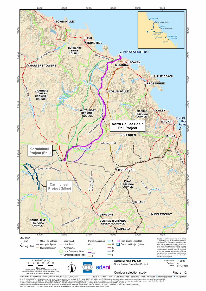
Figure 1-2 illustrates the eight corridors that were assessed in the multi-criteria analysis. This
multi-criteria analysis recommended Option 4C as the preferred corridor. This preferred corridor
GHD | Report for Adani Mining Pty Ltd - North Galilee Basin Rail, 41/26457 | 1-7
was refined to the preliminary investigation corridor and subsequently to a final rail corridor and
adjacent ancillary infrastructure areas through concept level engineering and design work
undertaken by Aarvee Associates.
The term ‘final rail corridor’ is used throughout the NGBR Project Environmental Impact
Statement (EIS) to describe this corridor. It is acknowledged that further constraints could be
identified through the EIS process that would further refine the final rail corridor.
It is noted that the final rail corridor presented in the EIS differs slightly to that presented in the
Initial Advice Statement which was submitted to the CG’s office in April 2013. The modified
alignment has been designed to further reduce the potential environmental impacts of the
NGBR Project. The amendments to the alignment have been developed subject to further
investigations undertaken during the EIS process and as a result of ongoing consultation with
relevant stakeholders and community groups.
The preferred option is the development of the NGBR Project, which comprises the construction
and operation of approximately 300 km of standard gauge railway connecting the proposed
Carmichael Coal Mine and Rail Project rail infrastructure (near Mistake Creek) directly with
supporting infrastructure (including rail loop/s and port infrastructure, the subject of separate
investigations) at the Port of Abbot Point. This preferred option will facilitate transport of up to
100 mtpa product coal directly to the Port of Abbot Point.
1.5.2 Co-location and co-use
Adani have investigated various other options for routing a rail corridor to the Port of Abbot Point
using co-location and / or co-use.
The proposed Carmichael Coal Mine and Rail Project, while enabling direct transportation of
coal to the Port of Hay Point (Dudgeon Point expansion), only allows for indirect transportation
to the Port of Abbot Point via the already constrained Goonyella rail system. As well as being
indirect, the Goonyella system has a much lower axle load with very limited capacity for
upgrade, all of which combined would act to increase coal prices and reduce the cost-
competitiveness of Galilee Basin coal in the global market.
Adani has considered developing and / or utilising a consolidated corridor with Waratah Coal’s
proposed China First Project, however, due to uncertain timeframes and the identification of a
more favourable and technically better route, opportunities for co-use and / or co-alignment with
the China First Project are limited. Adani has also previously considered co-utilising a
consolidated corridor with Hancock Coal Infrastructure’s proposed Alpha Coal Project (Alpha)
however, with the railway’s 60 mtpa capacity already fully allocated, uncertain development
timeframes and a route that traverses large flood plains, the potential for co-use of the railway is
limited.
Aurizon is seeking to develop an integrated rail system to service existing and proposed coal
mines in the Galilee Basin. The proposed Central Queensland Integrated Rail Project alignment
is a narrow gauge solution connecting to already congested and less scalable network on the
Newlands system. Moreover, the proposed Central Queensland Integrated Rail is a much
longer, and therefore less cost-effective, route to the Port of Abbot Point, besides being an
operationally less efficient narrow gauge system as compared to the heavy haul standard gauge
proposed for the NGBR Project. Opportunities to consolidate the Aurizon and Adani alignments
have been explored, however, due to uncertainty with regard to Aurizon’s development
timelines, in addition to the above technical aspects, Adani has decided to propose the much
shorter, standard gauge, NGBR Project.
1-8 | GHD | Report for Adani Mining Pty Ltd - North Galilee Basin Rail, 41/26457
The NGBR Project does offer the opportunity to provide a co-use outcome for the China Stone
Coal Project located north of the Carmichael Coal Mine.
1.5.3 Do nothing
The development of the NGBR Project will provide a direct link between the Galilee Basin’s vast
thermal coal resources to the Port of Abbot Point. The ‘do nothing’ option will result in increased
traffic on Aurizon’s Goonyella and Newlands rail systems and thus increase the bottleneck
situation currently being experienced on the existing rail system near Moranbah. This will
subsequently result in the need for an upgrade to a much larger section of each rail line with
associated social and environmental disturbances. The transportation of such a large quantity of
coal over the much longer narrow gauge route would increase costs of producing the thermal
coal, which in turn would reduce the cost-competitiveness of Galilee Basin coal in the global
market.
Carmichael Project (Rail)
Carmichael Project (Mine)
North Galilee BasinRail Project
Bow
e n RiverDonR
iver
Port Of Hay
Point
Port Of Abbot Point
ISAACREGIONALCOUNCIL
CHARTERSTOWERS
REGIONALCOUNCIL
BURDEKINSHIRE
COUNCIL
WHITSUNDAYREGIONALCOUNCIL
BARCALDINEREGIONALCOUNCIL
CENTRAL HIGHLANDSREGIONAL COUNCIL
MACKAYREGIONALCOUNCIL
Suttor Dev Road
Bowen Dev Road
Bruce Highway
Gregory Dev Road
Fitzroy Dev Road
Bruce Highway
Peak
Down
s High
way
Gregory Dev Road
Flinders Highway
Clermont - Alpha Road
Kilcu
mmin
- Diam
ond
Down
s Roa
d
Moray Car m ichael Road
LakeDalryrmple
Dunda Creek
Carmicha e l R iver
AYR
BOWEN
CALEN
DYSART
SARINA
MACKAY
CAPELLA
GLENDEN
CLERMONT
MORANBAH
HOME HILL
TOWNSVILLE
PROSERPINE
MIDDLEMOUNT
COLLINSVILLE
AIRLIE BEACH
CHARTERS TOWERS
Isaac River
Bur d ekin River
Bogie River
Su ttor Ri ve r
Broken River
Haughton RiverCa
peRi
ve r
Belyando River
Sellheim R ive r
Conno
rs River
Campaspe Ri v er
Pione
erRiv
er
Macke nzie River
Proserpine River
Isaac
River
450,000
450,000
500,000
500,000
550,000
550,000
600,000
600,000
650,000
650,000
700,000
700,000
7,450,
000
7,450,
000
7,500,
000
7,500,
000
7,550,
000
7,550,
000
7,600,
000
7,600,
000
7,650,
000
7,650,
000
7,700,
000
7,700,
000
7,750,
000
7,750,
000
7,800,
000
7,800,
000
7,850,
000
7,850,
000
Figure 1-2
LEGEND
© 2013. While GHD Pty Ltd has taken care to ensure the accuracy of this product, GHD Pty Ltd, DME, GA, ADANI and DNRM make no representations or warranties about its accuracy, completeness or suitabilityfor any particular purpose. GHD Pty Ltd, DME, GA, ADANI and DNRM cannot accept liability of any kind (whether in contract, tort or otherwise) for any expenses, losses, damages and/or costs (including indirector consequential damage) which are or may be incurred as a result of the product being inaccurate, incomplete or unsuitable in any way and for any reason.
Adani Mining Pty LtdNorth Galilee Basin Rail Project
Corridor selection study
Data Source: © Commonwealth of Australia (Geoscience Australia): Town, Railways, Watercourses (2007); DNRM: LGA, (2011), Hillshade (2009); DMR: State Roads (2008); DME: EPC1690 (2010), EPC1080 (2011); Adani: Alignment Opt9 Rev3 (2012), NGBR: Alignment Opt6 Rev 2, Rail Options (2013).
Level 9, 145 Ann St Brisbane QLD 4000 T +61 7 3316 3000 F +61 7 3316 3333 E [email protected] W www.ghd.com
A41-26457
01 Nov 2013Map Projection: Universal Transverse Mercator
Horizontal Datum: Geocentric Datum of Australia (GDA)Grid: Map Grid of Australia 1994, Zone 55
0 10 20 30 40 50
Kilometres
Based on or contains data provided by the State ofQLD (DNRM) [2013]. In consideration of the Statepermitting use of this data you acknowledge andagree that the State gives no warranty in relationto the data (including accuracy, reliability, complete-ness, currency or suitability) and accepts no liability(including without limitation, liability in negligence)for any loss, damage or costs (including conse-quential damage) relating to any use of the data.Data must not be used for marketing or be used inbreach of the privacy laws.
Job NumberRevision
Date
TownMajor Port
Other Rail NetworkGoonyella SystemNewlands System
Major RoadLocal RoadWatercourseLocal Government AreaCarmichael Project (Rail)
Previous AlignmentOption
12A3
44A4B4C5
North Galilee Basin RailCarmichael Project (Mine)
EMERALD
MOURA
TOWNSVILLE
ROCKHAMPTONGLADSTONE
CLERMONT
MACKAY
MORANBAH
Port Of Hay Point
Port Of Abbot Point
1:2,000,000 (at A4)
G:\41\26457\06 GIS\Maps\MXD\0001_Overview\41_26457_0012_rev_a.mxd
MERINDA
1-10 | GHD | Report for Adani Mining Pty Ltd - North Galilee Basin Rail, 41/26457
1.6 The environmental impact assessment process
1.6.1 Overview
An initial advice statement (IAS) was prepared for the NGBR Project, dated May 2013. The
purpose of the IAS was to provide the Coordinator-General with sufficient information to make a
coordinated project declaration under Section 26(1)(a) of the State Development and Public
Works Organisation Act 1971 (SDPWO Act). On 14 June 2013, the Coordinator-General
declared the NGBR Project to be a coordinated project requiring assessment via an EIS.
A referral under the Environment Protection and Biodiversity Conservation Act 1999 (EPBC Act)
was also prepared for the NGBR Project, dated May 2013. The purpose of the referral was to
provide the Department of Sustainability, Environment, Water, Population and Communities
(SEWPaC) with sufficient information to make a referral decision under the EPBC Act. In June
2013, SEWPaC issued a referral decision declaring the NGBR Project to be a controlled action.
SEWPaC later advised that the NGBR Project would require assessment via an EIS under the
EPBC Act, in parallel to the EIS assessment process being undertaken by the Coordinator-
General under the SDPWO Act.
This EIS has been prepared to meet the Terms of Reference (TOR) issued by the Coordinator-
General under the SDPWO Act. This EIS includes a Matters of National Environmental
Significance (MNES) chapter which assesses impacts on controlling provisions under the EPBC
Act including World Heritage Properties, Natural Heritage Places, Commonwealth Marine
Areas, EPBC listed threatened ecological communities, listed threatened species and listed
migratory species under Commonwealth legislation. The MNES chapter has been prepared in
accordance with the final Guidelines for an Environmental Impact Statement for the North
Galilee Basin Rail Project (EPBC 2013/6885).
This EIS will be submitted to both the Coordinator-General and SEWPaC for assessment under
the SDPWO Act and EPBC Act respectively.
1.6.2 EIS objectives
The objective of this EIS is to ensure that all potential direct and indirect environmental, social
and economic impacts of the NGBR Project are identified and adequately assessed, and that
appropriate mitigation and management measures are developed to minimise or avoid adverse
impacts. This EIS is the key environmental document for the assessment of the NGBR Project
and the granting of statutory approvals.
Another objective of this EIS is to serve as a platform for government agencies, stakeholders
and the local community to gain an understanding of the NGBR Project and provide valuable
feedback. For Adani, this EIS and associated draft Environmental Management Plan serve as a
definitive commitment to the mitigation and management measures that will be implemented to
minimise and avoid adverse environmental impacts that may result if the NGBR Project
proceeds.
1.6.3 EIS structure
The structure of this EIS is divided into two volumes. Volume 1 contains Chapters 1 to
Chapter 23 while Volume 2 contains Appendix A to Appendix T. The content of Volume 1
includes:
Chapter 1 - An introduction to the EIS, an assessment of the NGBR Project’s need and
alternatives, an overview of the community and stakeholder consultation undertaken for

GHD | Report for Adani Mining Pty Ltd - North Galilee Basin Rail, 41/26457 | 1-11
the NGBR Project and a summary of the environmental assessment process including
methodology for the assessment of potential environmental impacts
Chapter 2 - A detailed description of the NGBR Project
Chapter 3 to 23 – A detailed assessment of the various environmental aspects that have
the potential to be impacted by the NGBR Project. These chapters include existing
environment information, assessment of potential impacts as a result of the NGBR
Project, proposed mitigation and management measures, assessment of residual impacts
and assessment of cumulative impacts.
Volume 1 is divided into sections that link closely with the TOR structure to ensure that all
relevant matters concerning environmental and social values, resources and receptors are
addressed.
The content of Volumes 2 includes:
Appendix A - A cross-reference table to the TOR
Appendix B - A public consultation report summarising consultation that has been
undertaken for the NGBR Project and how issues raised by stakeholders and the
community have been addressed
Appendix C to N - Additional technical detail relating to background environmental
information that supports the environmental impact assessment undertaken in Volume 1
Appendix O - An offset strategy for identified residual impacts to State and
Commonwealth ecological values that cannot be avoided or mitigated
Appendix P – The framework for the Project Environmental Management Plan, which
includes all mitigation and management measures identified within Volume 1 and a
structure for implementing these measures during pre-construction, construction and
operation
Appendix Q - A summary of the technical team involved in the preparation of this EIS
Appendix R – Adani’s land acquisition protocol
Appendix S – A register of commitments made throughout Volume 1 of the EIS
Appendix T – Concept design drawings.
1.6.4 Environmental impact assessment methodology
Environmental impact assessment is the process undertaken to identify, evaluate and mitigate
potential environmental impacts of a proposed development. As the environmental assessment
for the NGBR Project included input from a wide range of technical disciplines, a systematic
approach was required to ensure consistency in describing the scale of impacts across the
range of studies such that significance of impacts were comparable. A standardised approach to
evaluating significance does not replace the methodologies used by technical disciplines to
identify or assess impacts, nor does it replace methods of impact assessment prescribed by
existing guidance. Rather, it adds to the impact assessment by providing clear, more readily
comparable conclusions regarding the significance of impacts. The standardised approach
employed for the NGBR Project involved:
Defining the sensitivity of environmental and social values, resources and receptors
Defining the impacts caused by the NGBR Project and their magnitude
1-12 | GHD | Report for Adani Mining Pty Ltd - North Galilee Basin Rail, 41/26457
Evaluating the significance of each impact
Identifying mitigation measures and calculating residual impact.
The environmental and social systems, resources and receptors potentially affected by the
NGBR Project were defined through desktop based research, field surveys and preliminary
consultation with state agencies, local councils, regional stakeholders and local communities. A
summary of the issues raised during consultation and how they were incorporated into the
environmental assessment is provided in Section 1.7.
To determine the magnitude of potential impacts from the NGBR Project, the scale of the
impact, its geographic extent, duration, reversibility, additive or cumulative effects and likelihood
of occurrence were considered. The significance of the impact was determined as a product of
the magnitude of impact and the sensitivity of the environment, resource, social value or
receptor that it would potentially impact. In order to standardise the significance of potential
environmental impacts, a multi-disciplinary workshops was held by the NGBR Project team in
June 2013. Volume 2 Appendix Q EIS team summary provides a list of the NGBR Project team
and their relevant technical experience.
In the instances where limited baseline data was available, a conservative approach was taken
by assuming the highest likely value and highest likely magnitude of impact. Any gaps in
information and assumptions made in determining the worst impact have been clearly stated in
the reporting, and mitigation measures have included recommendations for further studies,
reassessment once further information becomes available or a robust monitoring program.
The development of mitigation and management aimed to:
Be appropriate in terms of the effort and expense in relation to the scale and nature of the
impact
Target the protection and/or restoration of the systems/resources affected
Respond to the impact following a mitigation hierarchy (i.e. avoid > minimise > rehabilitate
> manage > offset / compensate).
An impact considered to be of extreme significance (where not simply considered grounds for a
fundamental re-design of the project) would need to be met with a high level of mitigation that
avoids, eliminates or makes provisions for full offsetting or compensation in advance and
ensures that measures are demonstrably effective. Compliance with international and national
standards and the use of specialists with internationally or nationally recognised expertise would
be required in development and implementation. A high level of ongoing monitoring would be
required.
Conversely an impact that was considered to be of low significance may either not need
mitigation at all or only require mitigation by control of impacts through day to day management
with only occasional monitoring required as validation.
Once mitigation measures were identified, residual impacts were assessed. This was achieved
through assessing and describing the effects of mitigation and subsequently, how the proposed
measures would reduce the magnitude of the impact significance. The application of mitigation
and management measures should in theory reduce the magnitude of the impact and hence
result in a reduced residual impact.
GHD | Report for Adani Mining Pty Ltd - North Galilee Basin Rail, 41/26457 | 1-13
1.6.5 Cumulative Impacts
Cumulative impacts can be defined as impacts on the environment, which result from the
incremental impact of an action when added to other past, present or reasonably foreseeable
future actions, regardless of what agency or person undertakes those other actions. Cumulative
impacts can result from individually minor but collectively significant actions taking place over a
period of time or from a combination of concurrent effects from a single action. Cumulative
impacts can be additive, synergistic or interactive and can result in impacts that are larger, more
significant and longer lasting than is the case with individual effects.
There is no defined process for undertaking cumulative impact assessments within Australia.
Setting boundaries is the process of establishing the limits of the area to be assessed for
cumulative impacts and the identification of activities within this boundary. The primary spatial
boundary for this cumulative impact assessment is the project footprint – this is the area that is
under project control and responsibility, i.e. the NGBR Project final rail corridor and associated
infrastructure. However, boundaries can vary from issue to issue and need to reflect ecosystem
requirements rather than artificial boundaries.
Cumulative impacts during the construction are likely to be short-term. Operation impacts are
more likely to be medium to long-term (e.g. continuing for more than two years after the activity
has ceased, or ongoing).
The potential cumulative impacts of the NGBR Project are assessed within Volume 1
Chapter 19 Cumulative impacts.
1.6.6 Ecologically sustainable development
An important consideration throughout development of the NGBR Project and preparation of this
EIS has been consideration of ecologically sustainable development. Ecologically sustainable
development is defined as ‘using, conserving and enhancing the community’s resources so that
ecological processes, on which life depends, are maintained, and the total quality of life, now
and in the future, can be increased (SEWPaC 1992). Ecologically sustainable development
focuses on assimilating economic expansion, social advancement and environment integrity in a
way that allows development to meet the needs of Australian’s today while conserving
ecosystems, and without impeding the ability of future generations to meet their own needs.
This EIS considers the beneficial and adverse cumulative impacts across the lifetime of the
NGBR Project and where possible provides mitigation and management measures that seek a
balance between environmental integrity, social development and economic development.
A core objective of ecologically sustainable development is following a path of economic
development in a way that enhances the individual and community well-being of current
generations, while safeguarding the welfare of future generations. The NGBR Project
represents a long-term investment in Queensland and Australia’s rail infrastructure with
significant economic and social benefits for current and future generations including:
Substantial employment opportunities during both construction (1,700 people) and
operation (369 people)
Increased jobs for local and state suppliers, services and contractors throughout both
construction and operation
Increased ability to export coal overseas at higher profit rates due to transport efficiency,
thereby aiding in the expansion of the Queensland economy
1-14 | GHD | Report for Adani Mining Pty Ltd - North Galilee Basin Rail, 41/26457
The NGBR Project will require a capital investment of approximately $2.2 billion and see the
development of key infrastructure that will enable effective coal transportation from the Galilee
Basin, one of Queensland’s largest coal reserves, to the Port of Abbot Point. The NGBR
Project will facilitate an increased rate of coal exportation from Queensland, thereby aiding in
the economic expansion of the State.
Another core objective of ecologically sustainable development is to provide for equity within
and between generations (SEWPaC 1992). This objective focuses not only on the short-term
(within generations) but also the long-term (between generations) environmental, social and
economic impacts. While the NGBR Project will have short and long-term environmental
impacts, a number of mitigation measures will be implemented to limit and avoid serious, long-
term and irreversible environmental damage. A benefit of the NGBR Project is that it will be
designed as a multi-user railway with a design life of more than 90 years, ensuring it remains
available for use by future generations.
Protecting biological diversity, and maintaining essential ecological processes and life-support
systems, is a third core objective of ecologically sustainable development (SEWPaC 1992). An
ecological assessment has been undertaken for the NGBR Project to determine the biological
diversity and ecological processes that have potential to be impacted (refer Volume 1 Chapter 6
Nature conservation). The alignment of the NGBR Project final rail corridor was selected taking
into consideration vulnerable and endangered terrestrial and aquatic flora and fauna species, as
well and threatened and endangered ecological communities. Where possible, modifications
have been made to the NGBR Project design to eliminate or minimise its effect on these
species and communities.
1.7 Community and stakeholder consultation
Stakeholder and community consultation has been an integral component of the NGBR Project
development and EIS process. The aim of consultation has been to inform stakeholders and the
broader community about the NGBR Project and to actively seek their involvement in the
identification of potential impacts and development of mitigation and management measures.
The key objectives of the consultation process included:
Establishing an open two-way flow of information
Communicating detailed NGBR Project information in an easy to interpret format
Facilitating opportunities for local and regional communities and other stakeholders to
identify issues, impacts and possible mitigation measures
Building community understanding and support for the EIS process.
A community and stakeholder consultation report was prepared for the NGBR Project and is
provided in Volume 2 Appendix B Public consultation.
1.7.1 Consultation methodology
A consultation plan was developed for the NGBR Project to ensure effective and timely
consultation during the EIS process. The consultation plan outlined:
The types of consultation activities to be undertaken
The timing of activities
Identification of key stakeholder and community representatives
Integration with other EIS activities and the project development process
GHD | Report for Adani Mining Pty Ltd - North Galilee Basin Rail, 41/26457 | 1-15
Consultation responsibilities
Communication protocols
Reporting and feedback arrangements
How consultation feedback will be considered by the proponent and integrated into the
EIS process.
Community and stakeholder engagement was undertaken in accordance with the principles of
the International Association of Public Participation (IAPP 2004). Stakeholders and the
community were engaged using a range of consultation and communication techniques,
including face-to-face meetings, briefings and public information sessions, as well as the
provision of information material, including factsheets. These were supported by stakeholder
feedback mechanisms, including a free call telephone line and NGBR Project email address.
A preliminary list of relevant stakeholders was developed through desk-based research.
Relevant stakeholders identified for the NGBR Project included Commonwealth, State and local
government representatives, potentially affected landowners, local businesses and residents,
community interest groups, industry representatives, environmental groups, media and
surrounding communities. A comprehensive list of affected and interested persons and how the
consultation process included these persons is provided in Volume 2 Appendix B Public
consultation.
Community and stakeholder consultation has been undertaken throughout the EIS process
including development of the draft and final TOR. This included meetings with state government
agencies, the council and other relevant stakeholders as well as community information
sessions. This approach aimed to ensure that multiple opportunities have been provided for
targeted stakeholders and the wider community to participate and comment on the NGBR
Project.
1.7.2 Draft Terms of Reference consultation
The draft TOR was publicly displayed by the Coordinator-General between 13 July 2013 and 12
August 2013. To encourage interest and participation in development of the final TOR,
community information sessions were held between 23 and 25 July 2013 at three locations,
Moranbah, Collinsville and Bowen. The events were advertised in local and regional
newspapers, and were staffed by representatives of the NGBR Project team. Participants were
provided with opportunities to give feedback on the NGBR Project either verbally (with notes
taken by the NGBR Project team), or in writing via submission.
Issues raised by submissions, were considered by the Coordinator-General in finalising the
TOR.
1.7.3 Commonwealth Government
A meeting was held with representatives of SEWPaC on 29 May 2013 to provide an overview of
the NGBR Project. This meeting focused on the description of the NGBR Project and the
connectivity of the NGBR Project to other projects in the region. Further consultation is planned
to be undertaken with SEWPaC in relation to the NGBR Project.
1-16 | GHD | Report for Adani Mining Pty Ltd - North Galilee Basin Rail, 41/26457
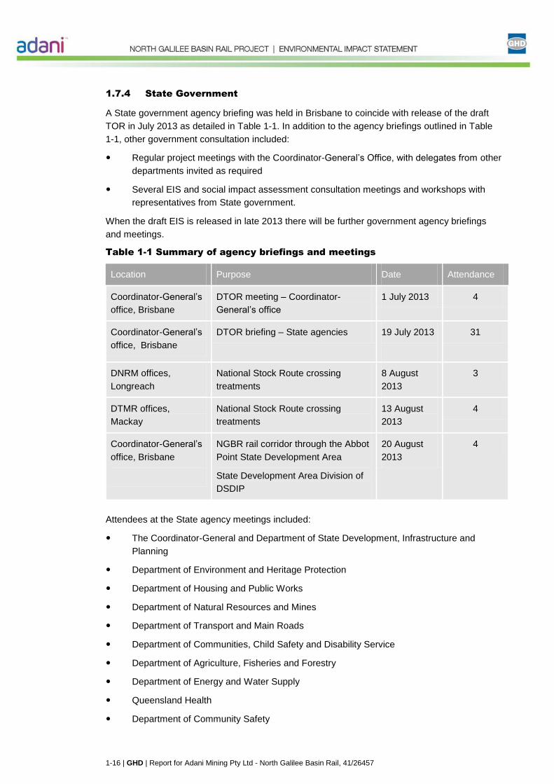
1.7.4 State Government
A State government agency briefing was held in Brisbane to coincide with release of the draft
TOR in July 2013 as detailed in Table 1-1. In addition to the agency briefings outlined in Table
1-1, other government consultation included:
Regular project meetings with the Coordinator-General’s Office, with delegates from other
departments invited as required
Several EIS and social impact assessment consultation meetings and workshops with
representatives from State government.
When the draft EIS is released in late 2013 there will be further government agency briefings
and meetings.
Table 1-1 Summary of agency briefings and meetings
Location Purpose Date Attendance
Coordinator-General’s
office, Brisbane
DTOR meeting – Coordinator-
General’s office
1 July 2013 4
Coordinator-General’s
office, Brisbane
DTOR briefing – State agencies 19 July 2013
31
DNRM offices,
Longreach
National Stock Route crossing
treatments
8 August
2013
3
DTMR offices,
Mackay
National Stock Route crossing
treatments
13 August
2013
4
Coordinator-General’s
office, Brisbane
NGBR rail corridor through the Abbot
Point State Development Area
State Development Area Division of
DSDIP
20 August
2013
4
Attendees at the State agency meetings included:
The Coordinator-General and Department of State Development, Infrastructure and
Planning
Department of Environment and Heritage Protection
Department of Housing and Public Works
Department of Natural Resources and Mines
Department of Transport and Main Roads
Department of Communities, Child Safety and Disability Service
Department of Agriculture, Fisheries and Forestry
Department of Energy and Water Supply
Queensland Health
Department of Community Safety
GHD | Report for Adani Mining Pty Ltd - North Galilee Basin Rail, 41/26457 | 1-17
Department of Education, Training and Employment
Queensland Police Service
Department of Local Government, Community Recovery and Resilience
Department of Aboriginal and Torres Strait Islander and Multicultural Affairs
Department of National Parks, Recreation Sport and Racing
As the meetings occurred in the initial phase of the EIS, discussions focussed on the project
description and the scope of the EIS, rather than impact identification or mitigation. Key issues
raised in these meetings and how they addressed within this EIS is summarised in Volume 2
Appendix B Public consultation.
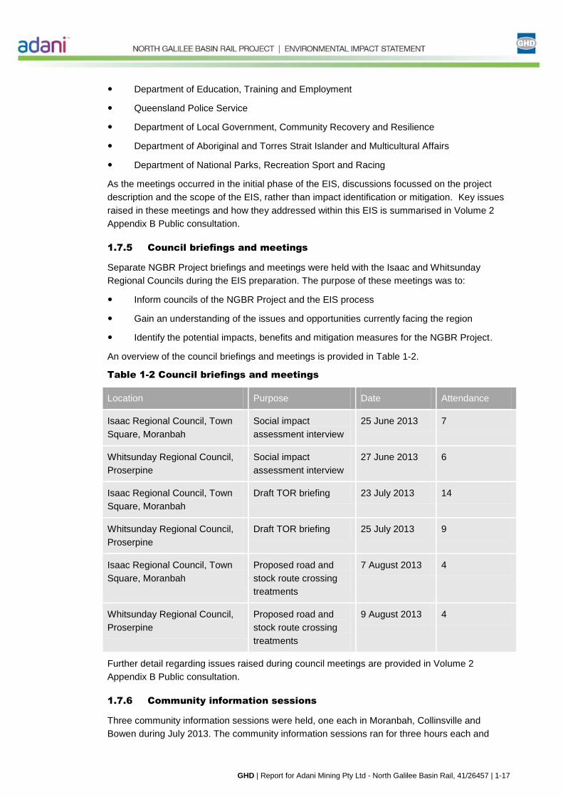
1.7.5 Council briefings and meetings
Separate NGBR Project briefings and meetings were held with the Isaac and Whitsunday
Regional Councils during the EIS preparation. The purpose of these meetings was to:
Inform councils of the NGBR Project and the EIS process
Gain an understanding of the issues and opportunities currently facing the region
Identify the potential impacts, benefits and mitigation measures for the NGBR Project.
An overview of the council briefings and meetings is provided in Table 1-2.
Table 1-2 Council briefings and meetings
Location Purpose Date Attendance
Isaac Regional Council, Town
Square, Moranbah
Social impact
assessment interview
25 June 2013 7
Whitsunday Regional Council,
Proserpine
Social impact
assessment interview
27 June 2013 6
Isaac Regional Council, Town
Square, Moranbah
Draft TOR briefing 23 July 2013 14
Whitsunday Regional Council,
Proserpine
Draft TOR briefing 25 July 2013 9
Isaac Regional Council, Town
Square, Moranbah
Proposed road and
stock route crossing
treatments
7 August 2013 4
Whitsunday Regional Council,
Proserpine
Proposed road and
stock route crossing
treatments
9 August 2013 4
Further detail regarding issues raised during council meetings are provided in Volume 2
Appendix B Public consultation.
1.7.6 Community information sessions
Three community information sessions were held, one each in Moranbah, Collinsville and
Bowen during July 2013. The community information sessions ran for three hours each and

1-18 | GHD | Report for Adani Mining Pty Ltd - North Galilee Basin Rail, 41/26457
were in a drop-in format, in which members of the community were encouraged to visit and
learn about the NGBR Project. Volume 2 Appendix B Public consultation provides an overview
of the key issues raised by stakeholders during community information session and where they
are addressed within the EIS
1.7.7 Other consultation
Consultation with landholders has been ongoing since February 2013 and included consultation
with all 29 directly affected landholders. Consultation and communication focussed on gaining
feedback on the NGBR Project alignment and facilitating land access agreements.
Consultation with Traditional Owners commenced in the first quarter of 2013 and included
negotiations regarding Cultural Heritage Management Plans (CHMPs). Consultation was also
undertaken with community groups and historical societies in Bowen and Collinsville, as well as
relevant local government authorities to assist in identifying potential non-Indigenous cultural
heritage places, and potential adverse impacts.
Further information regarding consultation with landholders and Traditional Owners is provided
Volume 2 Appendix B Public consultation.
1.7.8 Public exhibition of the EIS
Following acceptance of the draft EIS by the Queensland Coordinator-General and SEWPaC,
the document will be placed on public display for a submission period of 30 business days (or
as determined by the Coordinator-General and SEWPaC).
As part of the public exhibition period, the following will be undertaken:
Place public notices in local newspapers to provide details about:
– Timing of the public display period
– Locations where people can view the document, including static and staffed display
points, together with web-based information
– How to make public submissions in response to the EIS
Provide information about the public display period and submission requirements on
Adani’s website
Provide internet hosting of the draft EIS during the submission period
Produce and distribute an NGBR Project factsheet to publicise release of the EIS, provide
information on the public display process and call for submissions
Notify key stakeholders who are recorded on the NGBR Project’s database about the EIS
and review period
Conduct agency briefings and community information sessions to present findings of the
EIS.
1.7.9 How to make a submission
Written submissions on the draft EIS can be made by any interested party during the
submission period (refer Section 1.7.9). All submissions will be compiled by the Coordinator-
General and provided to Adani to inform preparation of additional information to the EIS.
The Coordinator-General and SEWPaC will consider written submissions on the NGBR Project
during the decision making process.
GHD | Report for Adani Mining Pty Ltd - North Galilee Basin Rail, 41/26457 | 1-19
A 'properly made' submission is one:
Made in writing to the Coordinator-General
Received on or before the deadline for submissions
Stating the name and address of each submitter
Signed by each submitter
Stating the grounds of the submissions and the facts and circumstances relied on in
support of the grounds.
Any submissions to the Coordinator-General should be addressed to:
The Coordinator-General
c/- EIS Project Manager – North Galilee Basin Rail
Coordinated Project Delivery
PO Box 15517
City East QLD 4002 Australia
1.7.10 Future consultation activities
Following completion of the public display period, all stakeholder and community feedback will
be reviewed and addressed in the final EIS document (or supplementary report if required).
A decision by the Coordinator-General about whether to approve the NGBR Project will be
made public via DSDIP’s and Adani’s websites. Adani will provide future updates about the
progress and status of the NGBR Project through its website.
Consultation will continue throughout the life of the NGBR Project to ensure due consideration
of all project-related opportunities and concerns. Further details on Adani’s plans for longer term
consultation as part of the NGBR Project’s construction and operation are included in Volume 1
Chapter 16 Social and economic impacts and Volume 2 Appendix P Environmental
management plan framework.