chapter 1: introduction - home page | california state ... · introduction. chapter 1: introduction...
TRANSCRIPT
1-1 BASIN PLAN – SEPTEMBER 11, 2014 INTRODUCTION
Chapter 1: Introduction Table of Contents The State and Regional Water Boards ............................................................................................... 2
Function of the Basin Plan .................................................................................................................. 3
Legal Basis and Authority ................................................................................................................... 6
History of Basin Planning and the Basin Plan in the Los Angeles Region...................................... 7
Continuing Planning Process ............................................................................................................. 9
Triennial Review Process ...................................................................................................................................9
Basin Plan Amendments .................................................................................................................................. 11
The Region ......................................................................................................................................... 12
Regional Setting ................................................................................................................................................ 12
Geology/Topography ........................................................................................................................................ 13
Climate ................................................................................................................................................................ 19
Land Use/Population ........................................................................................................................................ 22
Natural Resources ............................................................................................................................................ 25
Unique Habitats ................................................................................................................................................. 26
Water Resources/Water Quality ........................................................................................................ 27
Surface Waters/Watersheds ........................................................................................................................... 28
Ground Waters .................................................................................................................................................. 43
Other Sources of Water ................................................................................................................................... 47
Drought Considerations___________________________________________________________ 50
The Basin Plan ................................................................................................................................... 51

1-2 BASIN PLAN – SEPTEMBER 11, 2014 INTRODUCTION
The State and Regional Water Boards Responsibility for the protection of surface water and groundwater quality in California rests with the
State Water Resources Control Board (hereinafter, State Water Board) and nine Regional Water
Quality Control Boards (hereinafter, Regional Water Boards) (collectively, Water Boards). The Water
Boards are part of the California Environmental Protection Agency, along with the Air Resources Board,
the Department of Resources Recycling and Recovery, the Department of Pesticide Regulation, the
Department of Toxic Substances Control, and the Office of Environmental Health Hazard Assessment.
The State Water Board establishes statewide water quality control policy and regulation. The State
Water Board also coordinates Regional Water Board efforts and reviews Regional Water Board actions
for consistency with statewide policy and regulation.
The Regional Water Boards are semi-autonomous and make critical water quality decisions for their
region. All duties and responsibilities of the Regional Water Board are directed at providing reasonable
protection and enhancement of the quality of both surface and ground waters in the Region. The
programs by which these duties and responsibilities are carried out include:
• designating beneficial uses, establishing water quality objectives to protect those uses, and
identifying programs of implementation to meet objectives;
• developing new or revised policies addressing region-wide water quality concerns;
• issuing, monitoring compliance with, and enforcing waste discharge requirements and NPDES
permits and other orders;
• providing recommendations to the State Water Board on financial assistance programs, budget
development, and other statewide programs and policies;
• coordinating with other public agencies that are concerned with water quality control; and
• informing and involving the public on water quality issues.
Given the highly diverse environmental and land use characteristics of regions within the State, region-
specific water quality regulations are contained in Water Quality Control Plans (Basin Plans) that
recognize regional beneficial uses, water quality characteristics, and water quality problems.
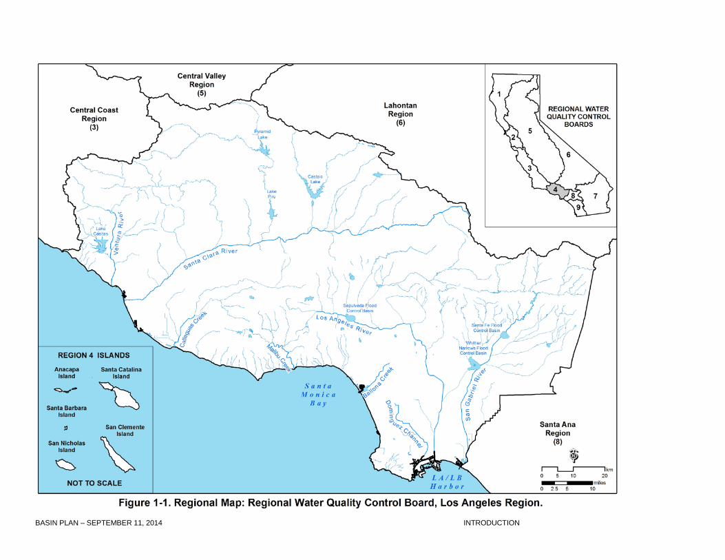
The California Regional Water Quality Control Board, Los Angeles Region (hereinafter referred to as
the Los Angeles Water Board or Regional Water Board) has jurisdiction over the coastal drainages
between Rincon Point (on the coast of western Ventura County) and the eastern Los Angeles County

1-3 BASIN PLAN – SEPTEMBER 11, 2014 INTRODUCTION
line (Figure 1-1). The Regional Water Board consists of seven part-time members appointed by the
Governor and confirmed by the State Senate, each of whom represents, and acts on behalf of, all of the
people. Members serve staggered four-year terms and must reside in, or have a principal place of
business within, the Region. Members of the Regional Water Board conduct their business at regular
meetings and public hearings at different locations throughout the Region at which public participation
is encouraged. The public may address the Regional Water Board regarding any matter within the
Regional Water Board's jurisdiction during the public forum of any regular Regional Water Board
meeting. The public may also address the Regional Water Board on specific items under consideration
at any Regional Water Board meeting. Copies of the Regional Water Board meeting agendas are
available on the Regional Water Board’s website at www.waterboards.ca.gov/losangeles. The staff at
the Regional Water Board, led by an Executive Officer appointed by the Board, implements the
Region’s water quality control programs and makes recommendations to the Regional Water Board
members regarding matters under its jurisdiction.
Function of the Basin Plan
The Regional Water Board's Basin Plan contains the Region’s water quality regulations and programs
to implement the regulations. The Basin Plan is designed to preserve and enhance water quality and
protect the beneficial uses of all regional waters. Specifically, the Basin Plan: (i) identifies beneficial
uses for surface and ground waters, (ii) includes the narrative and numerical water quality objectives
that must be attained or maintained to protect the designated beneficial uses and conform to the State's
anti-degradation policy, and (iii) describes implementation programs and other actions that are
necessary to achieve the water quality objectives established in the Basin Plan. In combination,
beneficial uses and their corresponding water quality objectives are called Water Quality Standards.
Major State and Regional Water Board resolutions, policies, plans, and Basin Plan amendments are
summarized in Chapter 5. In addition, all total maximum daily loads (TMDLs) applicable to waters
within the Region are referenced in Chapter 5 and, where adopted as an amendment to this Basin
Plan, are incorporated in Chapter 7. Regulations, plans, and policies of other agencies applicable to the
Regional Water Board’s programs are referenced in appropriate sections throughout the Basin Plan.
The Regional Water Board implements the Basin Plan by issuing and enforcing waste discharge
requirements to individuals, municipalities, or businesses whose waste discharges can affect water
quality. These requirements can be either State waste discharge requirements for discharges to land,
1-4 BASIN PLAN – SEPTEMBER 11, 2014 INTRODUCTION
or National Pollutant Discharge Elimination System (NPDES) permits issued under federal delegation
for discharges to surface water. The Regional Water Board also implements the Basin Plan by issuing
orders for investigation and cleanup or abatement at sites containing discharges of waste and by
prohibiting certain discharges of waste in some areas. The Basin Plan is also implemented by
encouraging water users to improve the quality of their water supplies, particularly where the
wastewater they discharge is likely to be reused.
The Basin Plan is reviewed and updated as necessary every three years through a process known as a
Triennial Review, which is discussed later in this chapter. Following adoption by the Regional Water
Board, amendments to the Basin Plan are subject to approval by the State Water Board, the State
Office of Administrative Law (OAL), and in some instances, the United States Environmental Protection
Agency (USEPA).
The Basin Plan is a resource for the Regional Water Board and others who use water and/or discharge
waste to surface or ground water in the Los Angeles Region. Other agencies and organizations
involved in environmental permitting and resource management activities also use the Basin Plan.
Finally, the Basin Plan provides valuable information to the public about local water quality issues.
1-5 BASIN PLAN – SEPTEMBER 11, 2014 INTRODUCTION
1-6 BASIN PLAN – SEPTEMBER 11, 2014 INTRODUCTION
Legal Basis and Authority California’s Porter-Cologne Water Quality Control Act (Porter-Cologne Act), enacted by the State of
California in 1969 and effective January 1, 1970, is considered landmark water quality legislation and
has served as a model for subsequent legislation by the federal government and other state
governments. This legislation, which became Division 7 of the California Water Code (Water Code, §
13000 et seq.), establishes the responsibilities and authorities of the nine Regional Water Boards
(previously called Regional Water Pollution Control Boards) and the State Water Board. The Porter-
Cologne Act identifies these Boards as “... the principal State agencies with primary responsibility for
the coordination and control of water quality" (§ 13001). Each Regional Water Board is directed to
“...formulate and adopt water quality control plans for all areas within the region,” including both surface
waters and groundwater (§ 13240). A water quality control plan for the waters of an area is defined as
having three components: beneficial uses to be protected, water quality objectives that protect those
uses, and a program of implementation needed to achieve the water quality objectives (§ 13050).
Further, “such plans shall be periodically reviewed and may be revised” (§ 13240). The State Water
Board is also authorized to adopt water quality control plans on its own initiative (§ 13170).
The Clean Water Act (CWA) (33 U.S.C. § 1251 et seq.), enacted by the federal government in 1972,
was designed to restore and maintain the chemical, physical, and biological integrity of the Nation's
waters. One of the national goals states that wherever attainable water quality should provide for the
protection and propagation of fish, shellfish, and wildlife, and provide for recreation in and on the water.
The CWA provides for the delegation of certain responsibilities in water quality control and water quality
planning to the states. Section 303(c) of the CWA directs states to establish water quality standards for
all “waters of the United States” and to review and update such standards on a triennial basis. Other
provisions of the CWA related to basin planning include Section 208, which authorizes the preparation
of waste treatment management plans, and Section 319 (added by 1987 amendments), which
mandates specific actions for the control of pollution from nonpoint sources. Section 307(a) of the
CWA also mandates that states adopt numerical standards for all priority pollutants.
Where USEPA and the State Water Board have agreed to such delegation, the Regional Water Boards
implement portions of the Clean Water Act, such as the NPDES program. The Code of Federal
Regulations (Title 40, C.F.R.) and USEPA guidance documents provide direction for implementation of
the CWA.
1-7 BASIN PLAN – SEPTEMBER 11, 2014 INTRODUCTION
The Porter-Cologne and Clean Water Acts also describe how enforcement of requirements pertaining
to discharges of waste is to be carried out. Enforcement tools available to the Regional Water Board
range from simple letters to the discharger, through formal Regional Water Board orders, and direct
assessments of administrative civil liability and penalties, to judicial civil and/or criminal enforcement
including civil liability, penalties, fines, and/or injunctive relief. Legally noticed public hearings are
required for most actions, but some enforcement actions (e.g., Cleanup or Abatement Orders) have
been delegated to the Executive Officer to allow for a quicker response than regularly scheduled
Regional Water Board meetings can provide.
In addition to state and federal laws, several court decisions provide guidance for basin planning. For
example, the 1983 Mono Lake Decision (National Audubon Society v. Superior Court (1983) 33 Cal.3d
419) reaffirmed the public trust doctrine, holding that the public trust is “an affirmation of the duty of the
state to protect the people's common heritage of streams, lakes, marshlands and tidelands,
surrendering that right of protection only in rare cases when the abandonment of that right is consistent
with the purposes of the trust.” Public trust encompasses uses of water for commerce, navigation,
fisheries, and recreation. In California Trout, Inc. v. State Water Resources Control Board ((1989) 207
Cal.App.3d 5856), the courts found that the public trust doctrine also applies to activities that could
harm the fisheries in a non-navigable water.
History of Basin Planning and the Basin Plan in the Los Angeles Region The Dickey Act, enacted by the State of California in 1949, established nine Regional Water Pollution
Control Boards in California. Regional Water Pollution Control Boards were directed to establish water
quality objectives in order to protect the quality of receiving waters from adverse impacts of wastewater
discharges. During the first few years, the Los Angeles Regional Water Pollution Control Board only
established narrative objectives for discharges. By 1952, the Los Angeles Regional Water Pollution
Control Board began including numerical limits in requirements for discharges and adopting water
quality objectives for receiving waters.
With the enactment of the Porter-Cologne Act in 1969, the names of the Regional Water Pollution
Control Boards were changed to Regional Water Quality Control Boards, and their authorities were

1-8 BASIN PLAN – SEPTEMBER 11, 2014 INTRODUCTION
broadened. At this time, the Regional Water Quality Control Boards initiated development of
comprehensive regional Basin Plans.
In 1971, the Regional Water Board adopted an Interim Water Quality Control Plan that compiled all of
the existing objectives and policies into one document and rescinded all individually adopted objectives
and policies. A more comprehensive planning effort was undertaken when the State Water Board
engaged Daniel, Mann, Johnson, and Mendenhall, Inc., and Koebig and Koebig, Inc. to develop Basin
Plans for the Santa Clara River Basin and the Los Angeles River Basin, respectively. This major
planning effort culminated in 1975 with the Water Quality Control Plan for the Santa Clara River Basin
(4A) and the Water Quality Control Plan for the Los Angeles River Basin (4B). Those two documents,
which together comprised the Basin Plans for the Los Angeles Region, were amended in 1976, 1978,
1990, and 1991. In 1994, the two 1975 Basin Plans and the aforementioned amendments to those
plans were superseded by a single Basin Plan, which for planning purposes divided the Region into
major surface watersheds and groundwater basins.
Since 1994, numerous Basin Plan amendments have been adopted and more current background,
program, and geographical information have become available. In 2010, the Regional Water Board
recognized the need for an overall update to the Basin Plan as several amendments to the Basin Plan,
which had been adopted since 1994 and were in effect, had not been physically integrated into the
Basin Plan. Also, the Basin Plan did not reflect current information on State and Regional Water Board
programs, plans, and policies, or more recently available geographical and background information for
the Los Angeles Region. As a result, an administrative update of the Basin Plan was identified as a
priority project to be addressed during the 2008-2010 triennial review (Resolution No. R10-001). The
administrative update was conducted in phases.
Since 1975, progress has been made toward the control of a number of water quality problems
identified in the 1975 Basin Plans, including the control of point source discharges from municipal
wastewater treatment plants, industrial facilities, and municipal separate storm sewer systems (MS4s)
and discharges from nonpoint sources such as irrigated agriculture in the Region. At the same time,
many new issues and areas of concern have arisen. Scientists continue to identify contaminants of
emerging concern (CECs) that pose ecosystem and public health risks. The State and Regional Water
Boards undertake a continuing planning process (described below), based on the latest scientific
information, which addresses both old and new water quality issues.

1-9 BASIN PLAN – SEPTEMBER 11, 2014 INTRODUCTION
Continuing Planning Process While the Basin Plan provides sound long-term standards and program guidance for the Region, it is
not a static document. The Basin Plan is a flexible tool that is reviewed and revised periodically to adapt
to changing conditions. The CWA and federal regulations (CWA § 303(e); 40 C.F.R. § 130.5(b)) require
that the State have a “continuing planning process” approved by the USEPA. This process has nine
required elements, one of which is water quality planning consisting of adoption, review, and
amendment of Basin Plans. As part of the State and Regional Water Board’s continuing planning
process, components of the Basin Plan are reviewed as new data and information become available or
as specific needs arise. Updates of the Basin Plan occur in response to this periodic review or as a
result of State or federal legislative requirements or judicial mandates such as consent decrees. State
Water Board and other governmental entities’ (federal, state, and local) plans that can affect water
quality are considered in the planning process.
Triennial Review Process Section 303(c)(1) of the CWA requires states to hold public hearings for the purpose of reviewing water
quality standards and, as appropriate, modifying and adopting standards, at least once every three
years, in a process known as a triennial review. Water quality standards consist of beneficial use
designations and water quality criteria (referred to as water quality objectives in State terminology)
necessary to protect those uses. This requirement is based upon recognition that the science of water
quality is constantly advancing; its purpose is to ensure that standards are based on current science,
methodologies, and USEPA mandates, recommendations, and guidance. The triennial review does not
involve the revision of all standards every three years. Federal law only requires modifications “as
appropriate.” Modifications to the Basin Plan are usually made to incorporate new scientific and
technical information; in response to USEPA’s mandates, applicable recommendations, and guidelines,
as appropriate; to address stakeholder concerns, where it is appropriate to do so; to address new
legislation or case law; and to address issues identified in due course by the State or Regional Water
Boards themselves or its staff during the regular course of business.
The availability of new scientific information or methodological developments may not directly translate
into a change to standards during a triennial review cycle. The state of the science also has to be taken

1-10 BASIN PLAN – SEPTEMBER 11, 2014 INTRODUCTION
into consideration; for example, it would be premature to modify standards while scientific
understanding is actively evolving and new methodologies are being developed and tested. Moreover,
notwithstanding the evolution of applicable scientific knowledge or policy considerations, federal or
state law or regulations may preclude changes that might otherwise be deemed desirable by
stakeholders. In addition, while a major part of the review process consists of identifying potential
issues, an important part of the review is the reaffirmation of those portions of the Basin Plan where no
potential issues are identified. Therefore, it is common for standards to remain unchanged as a result of
a triennial review process.
Even where changes are appropriate and lawful, the State’s Continuing Planning Process, and other
federally approved documents, recognize that the process of modifying water quality standards is
resource intensive, and typically limited by staffing and budgetary constraints. As such, the triennial
review process assists in identifying the most important or compelling projects and allows the State and
Regional Water Boards to prioritize those as resources allow.
This federal requirement for a triennial review of the Basin Plan is complemented by the provision in
Section 13240 of the California Water Code that requires a periodic review of the Basin Plan and allows
for revisions.
The triennial review occurs in three phases. During the first phase, the Board reviews water quality
standards and identifies potential issues for possible Basin Plan amendments that can be completed
within existing resource allocations over a three-year period. In the second phase, the Board holds a
hearing and prioritizes the standards-related issues on a priority list that will be further researched and
potentially addressed through subsequent Basin Plan amendments. Placing a potential issue on the
priority list will only require the Regional Water Board staff to investigate the need for an amendment; it
does not necessarily mean a revision of the Basin Plan will be made. Finally, during the third phase, the
Board, if appropriate, develops projects addressing these issues and adopts any resulting changes to
the Basin Plan as individual Basin Plan amendments over the course of the three-year review period.
Public input is a key component of each phase. Stakeholder input is solicited on issues of concern, on
prioritization, and during the development of each individual Basin Plan amendment. The triennial
review process may ultimately result in some amendments to the Basin Plan to adopt or modify water
quality standards and implementation provisions.
A triennial review is not the only occasion where Basin Plan modifications are contemplated. The
1-11 BASIN PLAN – SEPTEMBER 11, 2014 INTRODUCTION
Regional Water Board can amend the Basin Plan whenever needed. Such amendments need not
coincide with the triennial review process.
Basin Plan Amendments Amendments to the Basin Plan involve the preparation of an amendment, a resolution, a staff report,
and substitute environmental documents required by the California Environmental Quality Act
(California Public Resources Code, § 21080.5 et seq.). Public workshops are often held to inform and
solicit input from the public about issues before formal action is scheduled on the amendments.
Following a public review and comment period of 30 to 45 days, the Regional Water Board responds in
writing to timely submitted written comments. Subsequently, the Regional Water Board takes action on
the amendments at a public hearing. Basin Plan amendment hearings are advertised in the public
notice section of a newspaper circulated in areas affected by the amendment, as well as on the
Regional Water Board’s website. Persons interested in a particular issue can also notify the Regional
Water Board staff of their interest in being notified of workshops and hearings on that topic.
The California Environmental Quality Act provides that the Secretary of Resources can exempt
regulatory programs of State agencies from the requirements of preparing environmental impact
reports, negative declarations, and initial studies should such programs be certified as “functionally
equivalent.” The Water Board’s Basin Planning process has been so certified. Accordingly,
amendments to the Basin Plan and accompanying documentation, including the staff report, substitute
environmental document, and responses to comments, are functionally equivalent to an environmental
impact report or negative declaration.
Following adoption by the Regional Water Board, Basin Plan amendments and supporting documents
are submitted to the State Water Board for review and approval. All Basin Plan amendments approved
by the State Water Board after June 1, 1992 must also be reviewed and approved by the State Office of
Administrative Law (OAL). All amendments take effect upon approval by the OAL and filing of the
Department of Fish and Wildlife fee, where appropriate. In addition, the USEPA must review and
approve those Basin Plan amendments that involve surface water quality standards to ensure such
changes are consistent with federal regulations.
1-12 BASIN PLAN – SEPTEMBER 11, 2014 INTRODUCTION
The Region Regional Setting The Los Angeles Region (Figure 1-1) encompasses all coastal watersheds and drainages flowing to the
Pacific Ocean between Rincon Point (on the coast of western Ventura County) and the eastern Los
Angeles County line, as well as the drainages of five coastal islands (Anacapa, San Nicolas, Santa
Barbara, Santa Catalina, and San Clemente). In addition, the Region includes all coastal waters within
three nautical miles (approximately 5½ kilometers) off the continental and island coastlines.
The Regional Water Board relies on the watershed classification system developed by the United
States Geological Survey (USGS), known as the Watershed Boundary Dataset (WBD), which divides
surface waters into a hierarchical system of hydrologic units, areas, and subareas (Table 1-1 and
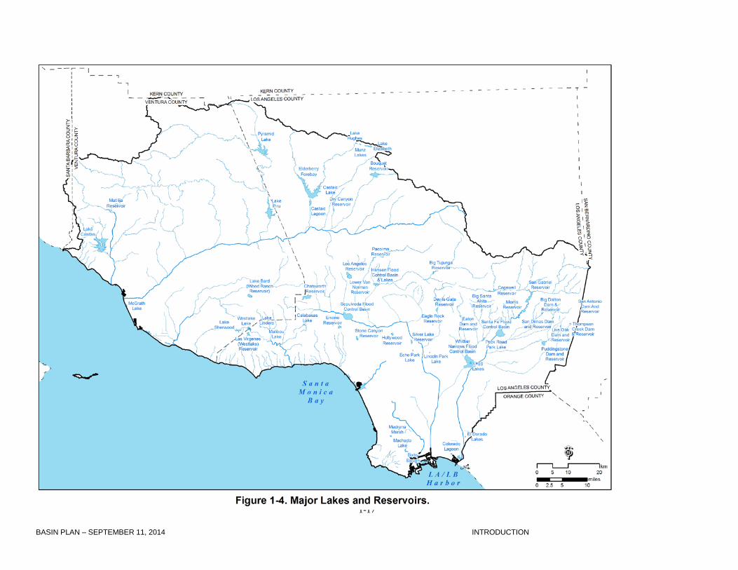
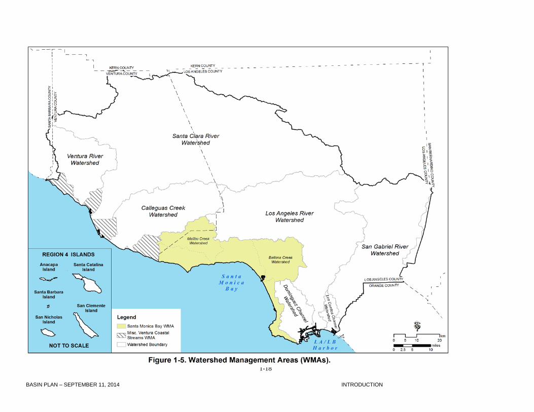
Figure 1-2). The USGS National Hydrography Dataset (NHD) is used to delineate surface waters,
including rivers, streams, lakes, and ponds. Figures 1-3 and 1-4 illustrate many of the larger streams
and lakes within the Region. The major watershed boundaries used for planning purposes are
illustrated on Figure 1-5. The eastern regional boundary, formed by the Los Angeles County line,
departs somewhat from the watershed divide; consequently, the Los Angeles and Santa Ana Regions
share jurisdiction over watersheds along their common border.
In addition, the Regional Water Board uses the classification system developed by the California
Department of Water Resources (as provided in the agency’s Bulletin 118 “California’s Groundwater”),
which divides ground waters into major groundwater basins (see Ground Waters, below). This system
also classifies surface waters into hydrologic units, areas, and subareas (Figure 1-2, Table 1-1).
Watersheds and watershed management areas used by the Regional Water Board for planning
purposes may be completely within a hydrologic unit or may cross several hydrologic units (e.g.,
Ventura County Coastal Watershed Management Area). In other cases, a hydrologic unit may contain
more than one watershed management area. For example, the San Gabriel Hydrologic Unit contains
the Los Cerritos and Dominguez Channel Watersheds in addition to the San Gabriel River Watershed.
Surface waters in the region are categorized by watershed and hydrologic unit codes in the beneficial
use tables contained in Chapter 2.

1-13 BASIN PLAN – SEPTEMBER 11, 2014 INTRODUCTION
Geology/Topography
Most of the Los Angeles Region lies within the western portion of the Transverse Ranges Geomorphic
Province. The San Andreas transform fault system, forming the boundary between the North American
and Pacific tectonic plates, dissects these western Transverse Ranges. This fault system, which
extends northwesterly for over 700 miles (1,127 kilometers) from the Salton Sea in southern California
to Cape Mendocino in northern California, bends in an east-west direction through the Transverse
Ranges. Known as the “Big Bend,” this portion of the San Andreas fault system formed from complex
movements of the Pacific Plate against the North American Plate. Compression generated by such
forces resulted in uplift of the Transverse Ranges, which have a conspicuous east-west trend (unlike
other major ranges in the continental United States, which typically have a roughly north-south trend).
Major mountain ranges within the Los Angeles Region include the San Gabriel Mountains, Santa
Monica Mountains, Santa Susana Mountains, Simi Hills, and Santa Ynez Mountains (Figure 1-6). The
San Gabriel Mountains are the most prominent range in this group. The rock types exposed in the San
Gabriel Mountains consist predominantly

1-14 BASIN PLAN – SEPTEMBER 11, 2014 INTRODUCTION

1-15 BASIN PLAN – SEPTEMBER 11, 2014 INTRODUCTION

1-16 BASIN PLAN – SEPTEMBER 11, 2014 INTRODUCTION
1-17 BASIN PLAN – SEPTEMBER 11, 2014 INTRODUCTION
1-18 BASIN PLAN – SEPTEMBER 11, 2014 INTRODUCTION
1-19 BASIN PLAN – SEPTEMBER 11, 2014 INTRODUCTION
of Mesozoic granitic rocks (66 to 245 million years old), with minor exposures of Precambrian igneous
and metamorphic rocks (prior to 570 million years old), and small stocks of Tertiary plutonic rocks (1.6
to 66 million years old). Cenozoic sedimentary beds (younger than 66 million years) are exposed only
at the margins of the San Gabriel Mountains. Reflecting the recent and continuing uplift from plate
tectonic activity, the San Gabriel Mountains are rugged mountains with deeply dissected canyons.
Eroded sediments from these mountains have formed and are continuing to form prominent alluvial
fans in the valleys along the flanks of the range.
During the Miocene Epoch (5 million to 23.5 million years ago), the sea advanced to the base of the
San Gabriel Mountains, depositing fine-grained marine sediments. As the sea retreated, coarser
grained sediments, eroded from the Transverse Ranges, were deposited as alluvial fans in low-lying
areas such as the San Fernando Valley, San Gabriel Valley, Oxnard Plain, and the Los Angeles
Coastal Plain (Norris and Webb, 1991). These low-lying areas or basins are filled with layers of
sediment. Many of these layers of sediment form aquifers that are important sources of groundwater in
the Region.
Climate With prevailing winds from the west and northwest, moist air from the Pacific Ocean is carried inland in
the Los Angeles Region until it is forced upward by the mountains. The resulting storms, common from
November through March, are followed by dry periods during summer months. Differences in
topography are responsible for large variations in temperature, humidity, precipitation, and cloud cover
throughout the Region. The coastal plains and islands, with mild rainy winters and warm dry summers,
are noted for their subtropical Mediterranean climate. The inland slopes and basins of the Transverse
Ranges, on the other hand, are characterized by more extreme temperatures and little precipitation.
Precipitation in the Region generally occurs as rainfall, although snowfall can occur at high elevations.
Most precipitation occurs during just a few major storms. Annual rainfall in Ventura County averages
16.1 inches (40.9 cm), although there is considerable variability in rainfall totals in dry versus wet years
and at high versus low elevations. In wet years, mountain areas can exceed 40 inches (101.8 cm) of
rain while in dry years, coastal lowlands can receive as little as 5 inches (12.7 cm) (VCWPD, 2007).
The average annual rainfall for Los Angeles County is 15.7 inches (39.9 cm). However, large variations
exist within Los Angeles County also, as indicated by average annual rainfall of 34.2 inches (86.9 cm)
at Cogswell Dam in the San Gabriel Mountains and average annual rainfall of 13.71 inches (34.82 cm)
for the coastal plain part of the County (LACDPW, 2011). These variations in precipitation are expected
1-20 BASIN PLAN – SEPTEMBER 11, 2014 INTRODUCTION
to increase as the impacts of climate change become more pronounced.

1-21 BASIN PLAN – SEPTEMBER 11, 2014 INTRODUCTION

1-22 BASIN PLAN – SEPTEMBER 11, 2014 INTRODUCTION
Land Use/Population Land use within the Region varies considerably (Figure 1-7). In Ventura County, land uses are
changing from agriculture and open space to urban residential and commercial. In southern Los
Angeles County, the predominant land uses include urban residential, commercial, and industrial. In
northern Los Angeles County, open space is rapidly being transformed into residential communities.
The economy in Los Angeles County is primarily industrial, commercial, and service; while in Ventura
County the economy is primarily agricultural, service, and commercial.
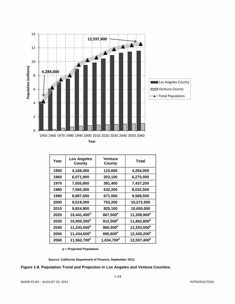
About 10.6 million people currently live in the Region (SCAG, 2011). From 1950 to 2000 the population
in the Region more than doubled. The Region’s population is projected to be 10.8 million by 2015 and
11.3 million by 2020 (State Department of Finance, 2011).

1-23 BASIN PLAN – SEPTEMBER 11, 2014 INTRODUCTION
1-24 BASIN PLAN – AUGUST 29, 2014 INTRODUCTION
p = Projected Population
Source: California Department of Finance, September 2013
Figure 1-8. Population Trend and Projection in Los Angeles and Ventura Counties.
0
2
4
6
8
10
12
14
1950 1960 1970 1980 1990 2000 2010 2020 2030 2040 2050 2060
Popu
latio
n (m
illio
ns)
Year
Los Angeles County
Ventura County
Total Population
12,597,400
4,284,000
Year Los Angeles County
Ventura County Total
1950 4,168,400 115,600 4,284,000 1960 6,071,900 203,100 6,275,000 1970 7,055,800 381,400 7,437,200 1980 7,500,300 532,200 8,032,500 1990 8,897,500 671,000 9,568,500 2000 9,519,300 753,200 10,272,500 2010 9,824,900 825,100 10,650,000 2020 10,441,400p 867,500p 11,308,900p 2030 10,950,300p 912,500p 11,862,800p 2040 11,243,000p 960,500p 12,203,500p 2050 11,434,600p 995,600p 12,430,200p 2060 11,562,700p 1,034,700p 12,597,400p

1-25 BASIN PLAN – AUGUST 29, 2014 INTRODUCTION
Natural Resources
Diversity in topography, soils, and microclimates of the Region supports a corresponding variety of
plant and animal communities. Native vegetation in the Region can be categorized into a number of
general plant communities including grasslands, coastal sage scrub, chaparral, oak woodland, riparian,
pinyon - juniper, and timber - conifer.
Chaparral is the most common type of vegetation association in the Region. It is generally located on
steeper slopes and has characteristics that make it highly flammable. Large expanses of chaparral are
found in the Santa Monica Mountains. Inland, coastal sage scrub occurs in the Simi Hills, Santa
Susana Knolls, Verdugo Hills, and San Gabriel Mountains. Oak woodland, with the easily identifiable
Valley oaks sometimes reaching heights of 20 to 60 feet (6.1 to 19.3 m), is dominant in Thousand
Oaks, Lake Casitas, Hidden Valley, Santa Clarita Valley, and elsewhere in the Transverse Mountain
Ranges. A large area of foothill oak woodland is found on Sulphur Mountain. Grasslands occur in
Point Mugu State Park and hillsides and valleys of northern Los Angeles (Ventura County, 2010; LA
County, 1980).
Riparian vegetation, found along most of the rivers and creeks, consists of sycamores, willows,
cottonwoods, and alders. Extensive riparian corridors occur along Piru, Sespe, Santa Paula, Malibu,
and Las Virgenes Creeks, Santa Clara, Ventura, and San Gabriel Rivers, as well as other rivers and
creeks of the Los Padres and Angeles National Forests. The riparian vegetation provides essential
habitat and wildlife corridors, supporting a great abundance and diversity of species (Ventura County,
2010; LA County, 1980).
The offshore environment also contains important resources. The dominant benthic habitat is soft
bottom, which consists of fine to moderately coarse sediments. Few attached plants live in this habitat
but invertebrates are abundant and diverse. Resident animals include crabs, shrimp, snails, worms,
and echinoderms. Hard bottom areas consist of seafloor covered with bedrock, gravel, and
phosphorite. Kelp beds will often be found in these hard bottom areas at depths of 20 to 70 feet (6.1 to
21.3 m). Although far less expansive in acreage than soft bottom habitat, kelp beds provide cover and
protection, and thus habitat for more than 800 species of fishes and invertebrates, some of which are
uniquely adapted for life in the beds. The open ocean habitat is the primary home to fish such as
Pacific sardine, northern anchovy, Pacific mackerel, and Pacific bonito as well as marine mammals
1-26 BASIN PLAN – AUGUST 29, 2014 INTRODUCTION
such as seals and sea lions. Many species of whales and dolphins are also observed offshore during
the winter/spring migration. Phytoplankton are the dominant plant life in the pelagic environment.
Sandy beaches are the most prominent and dominant habitat along the shoreline. Beaches support
species of macroinvertebrates such as sand crabs and Pismo clams; they also support surf fish, such
as California corbina, barred surfperch, and shovelnose guitarfish. Many sandy beaches are important
spawning grounds for California grunion. Intertidal zones include mud flats, tide pools, sandy beaches,
and wave-swept rocks. They provide important habitat and breeding grounds for a variety of plants
such as marine algae, fish such as grunion, and many invertebrates. Both beaches and other intertidal
zones are important nesting and feeding grounds for migratory waterfowl and shore birds such as
egrets, herons, gulls, terns, sanderlings, and plovers (CRWQCB-LA, 2010).
The existence of “ecological islands” as a result of topography and climatic changes has led to the
evolution of species, subspecies, and genetic strains of plants and animals in the Region. However,
increasing urbanization and development have resulted in the loss of habitat and a decline in biological
diversity. As a result, several native flora and fauna species have been listed as rare, endangered, or
threatened. Representative examples of endangered species include: California condor, American
peregrine falcon, California least tern, tidewater goby, unarmored threespine stickleback, Mohave
ground squirrel, conejo buckwheat, many-stemmed Dudleya, least Bell’s vireo, and slender-horned
spine flower (Ventura County, 2010; LA County, 1980).
Unique Habitats Habitats that support rare, threatened, endangered, or other sensitive plant or animal species are
unique, not simply because they support these species, but because they are unique habitats in terms
of their physical, geographical, and biological characteristics.
Because of the existence of kelp beds, tide pools, and significant ecological diversity, the nearshore
area between Laguna Point and Latigo Point is designated by the State Water Board as an Area of
Special Biological Significance (ASBS). An ASBS, also known as a State Water Quality Protection
Area, is a non-terrestrial marine or estuarine area designated to protect marine species or biological
communities from an undesirable alteration in natural water quality. An ASBS is afforded special
1-27 BASIN PLAN – AUGUST 29, 2014 INTRODUCTION
protection for marine life through requirements that waste discharges to the ASBS are prohibited or
limited by special conditions. There are eight ASBS in the Los Angeles Region (see Chapter 5).
The California Department of Fish and Wildlife designates marine protected areas (MPAs), which are
marine or estuarine waters set aside to protect or conserve marine life and its associated habitat. MPAs
are classified into several types based on the level of protection afforded to the area and the types of
uses that are permitted in the MPA. Marine protected areas are located in the vicinity of Point Dume,
the Palos Verdes Peninsula, Anacapa Island, Santa Barbara Island, San Nicolas Island, and Santa
Catalina Island.
Both Ventura and Los Angeles Counties have officially designated unique habitat areas that are
described in detail in the counties’ respective General Plans. The Ventura County Board of
Supervisors designated Significant Biological Resources in 1988 with the adoption of the General Plan
(Ventura County, 2010). The Los Angeles County Board of Supervisors designated Significant
Ecological Areas (SEAs) in 1980 with the adoption of the General Plan and similar areas on Santa
Catalina Island with the adoption of the Santa Catalina Island Local Coastal Plan in 1983. The
collection of SEAs together was intended to designate critical components of the biodiversity of Los
Angeles County as it was known and understood at that time (LA County, 1980). The section on
Surface Waters/Watersheds below describes some of the more significant biological resources and
ecological areas recognized by the counties in each watershed.
Water Resources/Water Quality The Los Angeles Region is the State's most densely populated and industrialized region. Despite this,
many of the watersheds in the Region encompass a great deal of diversity in level of development, land
use, topography, and socioeconomic characteristics. National forest land may dominate one part of a
watershed, while extensive development dominates another part. Irrigated agriculture and grazing
remain significant in parts of the Region. To add to this complexity, the Regional Water Board regulates
over 1,000 discharges of wastewater from a wide variety of municipal and industrial sources throughout
the Region and a vast network of municipal separate storm sewer systems serving two counties and 99
cities (CRWQCB-LA, 2007). The sources of water that sustain the Region are also diverse. Because
surface water and groundwater supplies within the Region are insufficient to support the population,

1-28 BASIN PLAN – AUGUST 29, 2014 INTRODUCTION
water imported from other areas meets about 50 percent of fresh water demands in the Region (MWD,
2010). In addition, the demand for water is increasingly being fulfilled by the use of reclaimed water for
indirect potable reuse (i.e. groundwater recharge) and non-potable purposes such as landscape
irrigation and industrial processing and servicing. (See Other Sources of Water, below.)
Surface Waters/Watersheds The rivers and streams of the Los Angeles Region flow from headwaters in pristine mountain areas
(largely in two National Forests -- the Angeles National Forest and Los Padres National Forest, and the
Santa Monica Mountains National Recreation Area), through urbanized foothill and valley areas, high
density residential, industrial, or intensely farmed coastal areas, and terminate at highly utilized
recreational beaches and harbors.
Coastal waters in the Region include bays, harbors, estuaries and lagoons, beaches, and the open
ocean. Santa Monica Bay dominates a large portion of the Region's open coastal waters and is a
nationally significant waterbody, which is part of the National Estuary Program. Deep-draft commercial
harbors include the Los Angeles/Long Beach Harbor complex and Port Hueneme. Shallower, small
craft harbors, such as Marina del Rey, King Harbor, and Ventura Marina, are spread along the
coastline. Coastal wetlands include regionally significant resources such as Mugu Lagoon and Malibu
Lagoon and numerous small coastal wetlands as well as larger ones such as the Ballona and Los
Cerritos Wetlands. Recreational beaches occur nearly uninterrupted along the entire length of the
Region’s coastline.
Coastal waters are impacted by a variety of activities, including:
• Municipal and industrial wastewater discharges
• Municipal separate storm sewer system discharges
• Cooling water discharges
• Failing onsite wastewater treatment systems (a.k.a. septic systems)
• Oil spills from tankers and offshore platforms
• Vessel wastes
• Dredging
• Increased development and loss of habitat
• Illegal dumping
1-29 BASIN PLAN – AUGUST 29, 2014 INTRODUCTION
• Natural oil seeps
Generally, largely uncontrolled discharges of pollutants from municipal separate storm sewer systems
and from nonpoint sources are believed to be the greatest threats to rivers and streams within the
Region. Recent advances in permitting municipal separate storm sewer system discharges, and control
of certain nonpoint sources are expected to remedy many of these threats.
Major surface waters in the Region are also specifically impacted by:
• Poor mineral quality in some areas due to geology, agricultural runoff, discharge of highly
mineralized groundwater, and high salinity levels in of some imported waters
• Bioaccumulation of toxic compounds in fish and other aquatic life
• Impacts from increased development and recreational uses
• In-stream toxicity from point and nonpoint sources
• Diversion of flows necessary for the propagation of fish and wildlife populations
• Channelization, dredging, and other losses of habitat
• Impacts from transient camps located along creeks and lagoons
• Illegal dumping
• Introduction of non-native plants and animals which displace native biota
• Impacts from sand and gravel mining operations
• Natural oil seeps
• Eutrophication and the accumulation of toxic pollutants in lakes
The Region encompasses ten Watershed Management Areas (WMAs), which generally consist of a
single large watershed within which exist smaller subwatersheds that are tributary to the mainstem
river. However, in some cases they may be a collection of drainage areas that does not meet the strict
hydrologic definition of a watershed (e.g., several small Ventura coastal waterbodies in the Region are
grouped together into one WMA). Watersheds in the strictest sense are geographic areas draining into
a river system, ocean, or other body of water through a single outlet and include the receiving waters.
They are usually bordered, and separated from, other watersheds by mountain ridges or other naturally
elevated areas.
1. Ventura River Watershed: The Ventura River is the northernmost major river system in the
Region; it drains an area of 235 square miles (609 square kilometers) situated within the western
1-30 BASIN PLAN – AUGUST 29, 2014 INTRODUCTION
Transverse Ranges. Topography in the watershed is rugged and, as a result, the surface waters that
drain the watershed have very steep gradients, ranging from 40 feet per mile (7.6 m per km) at the
mouth to 150 feet per mile (28.4 m per km) at the headwaters. The watershed supports a number of
sensitive aquatic species, several of which are endangered or threatened. Water quality in the upper
reaches is good but quality in the lower reaches is influenced by a combination of municipal wastewater
discharges, agricultural activities, livestock, MS4 discharges, and oil industry discharges among other
sources of pollutants. Excessive algae occurs at many locations. Wetlands are found at the Ventura
River estuary, along the river itself, bordering lakes, and at isolated low-lying areas within the
watershed such as Ojai Meadows (CRWQCB-LA, 2007).
Local populations of steelhead and rainbow trout have been greatly reduced in the watershed through
physical barriers to migration and diverted stream flows. A limited resident population of rainbow trout
occurs above Robles Diversion Dam and in San Antonio Creek and the lower Ventura River. Migratory
steelhead trout ascend upstream in the Ventura River and into San Antonio Creek and may utilize
areas above the Robles Diversion Dam via a fish passageway.
Multiple interested agencies, and other entities, however, have recognized the potential for the
restoration and enhancement of steelhead populations in the Ventura River through the removal of
Matilija Dam, which blocks access to a large area of prime spawning habitat (USACE and VCWPD,
2004). Ventura County has explored alternatives and is seeking funding to realize this removal.
The wetland at the mouth of the Ventura River is considered to be a Significant Biological Resource by
Ventura County due to its ability to provide habitat for thousands of biota that include endangered, rare,
or threatened species. The mainstem of the river as well as San Antonio Creek are also listed as
Significant Biological Resources due to their use by steelhead trout. “Critical” condor habitat exists in
three areas in Ventura County, including Matilija Creek (Ventura County, 2010).
Residents and agricultural interests in this watershed are entirely dependent on local surface water and
groundwater since there is no connection to the State Water Project to deliver imported water.
2. Santa Clara River Watershed: The Santa Clara River, at approximately 100 miles (161
kilometers) in length with a 1200 square mile (3,108 square kilometer watershed), is the largest river
system in southern California that remains in a relatively natural state. The river originates on the

1-31 BASIN PLAN – AUGUST 29, 2014 INTRODUCTION
northern slope of the San Gabriel Mountains in Los Angeles County, traverses Ventura County, and
flows into the Pacific Ocean halfway between the cities of San Buenaventura and Oxnard. Land use in
the watershed is predominately open space; residential, agriculture, and some industrial uses occur
along the mainstem (CRWQCB-LA, 2007).
Threats to water quality include increasing development in floodplain areas (particularly in the upper
watershed), necessitating flood control measures such as channelization that results in increased flows,
erosion, and loss of habitat. In many of these highly disturbed areas the exotic giant reed (Arundo
donax) is gaining a foothold. Increasing loads of nitrogen (from irrigation and onsite wastewater
treatment discharges) and salts such as chloride (from irrigation and publicly owned treatment works
(POTW) discharges) in surface and groundwaters threaten beneficial uses, including irrigation and
drinking water supply. Additionally, stream flows are diverted, usually during high flow, for groundwater
recharge or direct delivery; wells are then pumped for municipal and agricultural uses. Thirty-six
percent of the watershed is controlled by dams such as Santa Felicia and Pyramid Dams on Piru Creek
and Castaic Dam on Castaic Creek. The hydrology of the river is complex; perennial flows occur in
some portions of the river before disappearing into the permeable bed material and then reappearing
further downstream where groundwater surfaces. Groundwater underlying the Santa Clarita Valley in
the upper watershed has been impacted by perchlorate contamination. The chemical was originally
detected in four Saugus wells in 1997 near the former Whittaker-Bermite industrial facility. Since then,
the wells have been out of water supply service. Remediation of the perchlorate and restoration of the
impacted well capacity is underway (CRWQCB-LA, 2006 and 2007).
While there are several small publicly owned treatment works (POTWs) in the Ventura County portion
of the watershed and two larger POTWs in the upper watershed, many of the smaller communities in
the watershed remain unsewered. In particular, in the Agua Dulce area of the upper watershed,
impacts to drinking water wells from onsite wastewater treatment systems are of concern. The
community has undertaken a wellhead protection effort, with oversight by Regional Water Board staff
(CRWQCB-LA, 2007).
Significant Biological Resources described in Ventura County’s General Plan include the extensive
patches of high quality riparian habitat that are present along the length of the river and its tributaries.
Also considered significant are areas such as the wetlands found at the Santa Clara River estuary,
along the river itself, bordering lakes, and at isolated low-lying areas within the watershed such as the

1-32 BASIN PLAN – AUGUST 29, 2014 INTRODUCTION
"Pothole" in the Devil's Potrero (on Agua Blanca Creek) that supports several species of plants unique
to freshwater marshes (Ventura County, 2010). In the upper part of the watershed, within Los Angeles
County, SEAs have been designated including: (1) the Santa Clara River SEA, which also includes the
previously designated Kentucky Springs SEA (a distinctive stand of great basin sagebrush) and the
previously designated San Francisquito Canyon SEA (which provides habitat for the endangered
threespine stickleback); (2) the Santa Susana and Simi Hills SEA, which includes the previously
designated Lyons Canyon SEA (a chaparral and oak woodland); and (3) the Valley Oaks Savannah
near Newhall (LA County, 1980 and 2011).
One of the largest of Santa Clara River's tributaries, Sespe Creek, contains most of the Santa Clara
River's remnant, but restorable, run of the steelhead trout. Sespe Creek is designated as a “Wild Trout
Stream” by the State of California and supports significant steelhead spawning and rearing habitat.
Additionally, the federal Los Padres Wilderness Act (1992) permanently set aside portions of Sespe
Creek for steelhead trout protection and designated Sespe Creek as a “Wild and Scenic River” and
Ventura County considers Sespe Creek a Significant Biological Resource. The Pacific lamprey,
another anadromous fish, also uses Sespe Creek and the Santa Clara River for spawning (Ventura
County, 2010).
The Sespe Condor Sanctuary was dedicated in 1947 and set aside 53,000 acres (21,448 hectares) in
aide of that species’ recovery. The Sanctuary is surrounded on the west, north, and east by critical
condor habitat and the Hopper Mountain National Wildlife Refuge is to the south of the Hopper
Mountain area. "Critical" condor habitat exists for three areas in Ventura County including Mount Pinos
and Sespe-Piru. All federal agencies must ensure that actions authorized, funded, or carried out by
them do not result in the destruction or modification of these critical habitat areas. "Essential" habitat
includes those areas intended to supplement the officially designated critical habitat. These areas have
no legal status unlike “Critical Habitat” areas; however, the habitat management recommendations are
intended to be applied with equal emphasis in these areas. The essential habitat in the watershed
extends the Sespe-Piru critical habitat -- on the northeast to Liebre Mountain in Los Angeles County
and on the west to Madulce Peak in Santa Barbara County (Ventura County, 2010).
Piru and Santa Paula Creeks, two other tributaries of the Santa Clara River, also support good habitat
for steelhead, although both contain barriers to migration. Additionally, the Santa Clara River has
populations of unarmored threespine stickleback, Santa Ana suckers, arroyo toads, and California least

1-33 BASIN PLAN – AUGUST 29, 2014 INTRODUCTION
Bell’s vireo. San Francisquito Canyon, Placerita Canyon, Soledad Canyon, Castaic, and Elizabeth
Canyon Creeks are smaller tributaries that all provide valuable habitat. The Santa Clara River also
serves as an important wildlife corridor (CRWQCB-LA, 2006).
Residents and agricultural interests in this watershed are dependent on a mix of local surface water
and groundwater as well as imported water. Several large reservoirs are used to store imported water,
which is also used to recharge groundwater basins. Use of recycled water is practiced extensively in
the dryer upper watershed.
3. Calleguas Creek Watershed: Calleguas Creek and its major tributaries, Revolon Slough, Conejo
Creek, Arroyo Conejo, Arroyo Santa Rosa, and Arroyo Simi drain an area of 343 square miles (888
square kilometers) in southern Ventura County and a small portion of western Los Angeles County.
The Santa Susana Mountains, South Mountain, and Oak Ridge form the northern boundary of the
watershed, while the Simi Hills and Santa Monica Mountains form the southern boundary (CRWQCB-
LA, 2007).
Calleguas Creek drains a predominantly agricultural area on the Oxnard Plain as well as a mix of
agricultural, residential, and open space areas further inland; it empties into Mugu Lagoon, one of
southern California's few remaining large wetlands, which supports a rich diversity of fish and wildlife.
The lagoon borders on an ASBS and supports a great diversity of wildlife including several endangered
birds and one endangered plant species (CRWQCB-LA, 2007). The wetland at Mugu Lagoon is
considered to be a Significant Biological Resource by Ventura County due to its ability to provide
habitat for thousands of biota include endangered, rare, or threatened species (Ventura County, 2010).
Additionally, a small portion of the eastern end of the watershed falls within Los Angeles County, which
has designated several SEAs including the Santa Susana Mountains, Santa Susana Pass, and the
Simi Hills (Los Angeles County, 1980).
While natural creek flows in the past were intermittent in this fairly low-gradient watershed, discharges
of municipal, agricultural, and urban wastewaters have increased surface flow in the watershed
resulting in increased sedimentation in the lagoon. The general instability of the streambanks,
continual destruction of riparian vegetation, and other land use practices have accelerated erosion in
the watershed. Erosion problems are intensified in areas where residential development is occurring
on steeply sloping upland areas.
1-34 BASIN PLAN – AUGUST 29, 2014 INTRODUCTION
Aquatic life in both Mugu Lagoon and the inland streams of this watershed has been impacted by a
variety of pollutants including DDT, PCBs, other pesticides, and some metals. High concentrations of
minerals and nitrates are common in surface water as well as groundwater. The elevated levels of
salts are as a result of applied imported water and agriculture, and are expected to be addressed
through the use of groundwater desalters and the advanced treatment of wastewater effluents via
reverse osmosis. The brine solution produced from these processes will be disposed of through a
Salinity Management Pipeline (brine line), currently under construction, which will discharge to the
Pacific Ocean.
Sediment toxicity is also elevated in some parts of the lagoon. Reproduction is impaired in the resident
endangered species, such as the light-footed clapper rail, due to elevated levels of DDT and PCBs.
Overall, this is a very impaired watershed (CRWQCB, 2007).
While residents and agricultural interests in this watershed utilize some local groundwater, they are
highly dependent on imported water; use of reclaimed water is increasing.
4. Miscellaneous Ventura Coastal WMA: The WMA is composed of four separate coastal drainage
areas located between the Regional boundary, Ventura River, Santa Clara River, and Calleguas Creek
Watersheds as well as the Santa Monica Bay WMA. The drainage areas are typified by either small
coastal streams, wetlands, or marinas/urban centers (CRWQCB-LA, 2007). The WMA encompasses
an area that historically consisted of extensive wetlands (Grossinger, et al. 2011). Many unique
habitats, including coastal wetlands and lagoons, such as McGrath Lake and Ormond Beach Wetlands,
and the nearby coastal dunes remain and are found along the southern coast of Ventura County. They
are considered to be Significant Biological Resources by Ventura County. These areas provide
habitats for many fish, birds, invertebrates, sea lions, and other marine and estuarine species (Ventura
County, 2010).
The water quality problems found at the coastal wetlands generally involve legacy and current-day
pesticides since most of the wetlands are located adjacent to or downstream of agricultural areas.
Some of these wetlands receive runoff from urban areas through sizable drains and pollutants
associated with MS4 discharges will additionally be found. The water quality problems found at the
marinas in the WMA generally involve elevated metals and, at times, legacy pesticides. While there is

1-35 BASIN PLAN – AUGUST 29, 2014 INTRODUCTION
a POTW in the WMA, which discharges to the ocean, some of the smaller communities in the WMA
remain unsewered. The Regional Water Board determined that wastewater is contaminating the
underlying groundwater basin (Oxnard Forebay) in the El Rio area on the Oxnard Plain. Since
groundwater from the basin is used as a drinking water supply for the area, this contamination, with
pathogens and nitrogen compounds, is impairing the beneficial use of the groundwater. The Regional
Water Board amended the Basin Plan in August 1999 to prohibit new onsite wastewater treatment
systems in the Oxnard Forebay, including El Rio and Saticoy areas, and discharge of septic effluent for
lots less than 5 acres by January 1, 2008. Implementation of the prohibition continues. (CRWQCB-LA,
2007).
While residents and commercial/agricultural interests in this WMA utilize some local groundwater, they
are highly dependent on imported water.
5. Santa Monica Bay WMA: The Santa Monica Bay WMA encompasses an area of 414 square
miles (1,072 square kilometers). Its borders reach from the crest of the Santa Monica Mountains on the
north and from the Ventura-Los Angeles County line to downtown Los Angeles. From there it extends
south and west across the Los Angeles plain to include the area east of Ballona Creek and north of the
Baldwin Hills. A narrow strip of land between Playa del Rey and Palos Verdes drains to the Bay south
of Ballona Creek. The WMA includes waters that flow into the Bay through 28 catchment basins that
can be grouped into nine watershed areas based on their geographic characteristics. The two largest
watersheds are Malibu Creek to the north (west) and Ballona Creek to the south. The smaller Topanga
Creek Watershed is located partway between Malibu and Ballona. Many of the beaches lining the Bay
are impaired for bacteria, while the nearshore and offshore zones are impaired due to DDT and PCBs
(CRWQCB-LA, 2010).
The WMA contains a number of SEAs designated by Los Angeles County due to their unique,
uncommon, or scientifically interesting features including: Point Dume, Upper La Sierra Canyon,
Malibu Canyon and Lagoon, Hepatic Gulch, Cold Creek, and Las Virgenes. Other areas were selected
to provide examples of the more common habitats and to ensure that the full range of the remaining
biotic and geographic diversity in the region was represented. These areas include: Zuma Canyon,
Tuna Canyon, Temescal-Rustic-Sullivan Canyons, and Palo Comado Canyon. Additionally, Agua
Amarga Canyon on the Palos Verdes Peninsula is designated as a SEA, as well as the Palos Verdes
Peninsula coastline, Portuguese Bend Landslide, Ballona Creek, the El Segundo Dunes, the Malibu
1-36 BASIN PLAN – AUGUST 29, 2014 INTRODUCTION
coastline, and the Malibu Creek State Park Buffer Area (LA County, 1980).
Residents and commercial/industrial interests in this WMA are highly dependent on imported water; use
of recycled water is increasing.
Malibu Creek Watershed: The Malibu Creek Watershed, at about 109 square miles (282 square
kilometers), is one of the largest draining to Santa Monica Bay. Approximately two-thirds of this
watershed lies in Los Angeles County and the remaining third is in Ventura County. Much of the land is
part of the Santa Monica Mountains National Recreation Area and is under the purview of the National
Park Service (CRWQCB-LA, 2007). The watershed has changed rapidly in the last 30 years from a
predominantly rural area to a steadily developing area that has increased in population to nearly 90,000
residents. Increased flows and channelization of several tributaries to Malibu Creek have caused an
imbalance in the natural flow regime in the watershed and have led to habitat impacts in Malibu Lagoon
at the mouth of the watershed. Restoration efforts, completed by the California Department of Parks
and Recreation and the California Coastal Conservancy in 2013, improved the natural structure and
function of the Lagoon.
Pollutants of concern, many of which are discharged from nonpoint sources, include excess nutrients,
sediment, and bacteria. In response to the ongoing bacterial and nutrient pollution in this area, the
Regional Water Board adopted a prohibition of discharges from onsite wastewater treatment systems
(i.e., septic systems) in the Malibu Civic Center Area in 2009 (see Chapter 4).
Malibu Lagoon supports two important plant communities, the coastal salt marsh and coastal strand,
and is an important refuge for migrating birds (over 200 species of birds have been observed). As
Malibu Canyon dissects the Santa Monica Mountains, species normally restricted to the drier interior
valleys have extended their range down the canyon. Perennial streams in Malibu Canyon support oak
and riparian woodlands. Malibu Creek is also the southernmost watercourse in California where
steelhead trout continue to spawn in relatively large numbers despite a major barrier to upstream
migration, Rindge Dam.
Topanga Creek Watershed: The Topanga Creek Watershed is located east of Malibu and covers an
area of 18 square miles (47 square kilometers) within the Santa Monica Mountains. Topanga Creek
flows through a small town center and residential areas in the upper reaches and through steep, narrow

1-37 BASIN PLAN – AUGUST 29, 2014 INTRODUCTION
gorges in the lower reaches, ultimately emptying into the ocean just south of Pacific Coast Highway. A
small lagoon exists at the mouth of the creek due to a berm created by littoral drift and wave action.
Bacteria levels are of concern in the lagoon. The lower reaches of the creek flow year-round and
support a small population of spawning steelhead trout aided by deep pools where temperatures
remain cooler (CRWQCB-LA, 2010).
Ballona Creek Watershed: Ballona Creek, at approximately 127 square miles (329 square kilometers),
is the largest drainage tributary to Santa Monica Bay and discharges to the ocean adjacent to the
entrance of the Marina del Rey Harbor. The mostly channelized creek collects runoff from several
partially urbanized canyons on the south slopes of the Santa Monica Mountains as well as from
intensely urbanized areas of West Los Angeles, Culver City, Beverly Hills, Hollywood, Inglewood, Santa
Monica, and parts of central Los Angeles (CRWQCB-LA, 2007). The watershed encompasses an area
that historically consisted of extensive wetlands (Grossinger, et al. 2011). The current-day Ballona
Wetlands are located near the mouth of the creek and represents one of the few remaining regionally
significant coastal wetlands along Santa Monica Bay. The complex of wetlands is a mixture of habitats
dominated by coastal salt marsh; a number of special status species are supported there including
Belding’s Savannah Sparrow (CRWQCB-LA, 2007). In 2004, the State of California acquired ownership
of this remaining wetland area (600 acres (243 hectares) in total), and the California Department of Fish
and Wildlife, the State Lands Commission, and the State Coastal Conservancy have been working with
stakeholders, scientist, and other agencies to develop plans for its restoration (CSCC, 2008).
A large number of pollutants associated with urban development are found in the creek and, in turn,
impact the nearby beaches and ocean. In addition, high concentrations of DDT in sediments at the
mouth of the creek and in Marina Del Rey Harbor provide evidence of past discharges that have
resulted in long-term water quality problems.
6. Dominguez Channel and Los Angeles/Long Beach Harbors WMA: The Los Angeles and Long
Beach Harbors are located in the southern portion of the Los Angeles Basin and occupy an area that
was once a vast wetlands complex (Grossinger, et al. 2011). Along the northern portion of San Pedro
Bay is a natural embayment formed by a westerly extension of the coastline which contains both
harbors, with the Palos Verdes Hills the dominant onshore feature. The channelized 15-mile (24-
kilometer) long Dominguez Channel enters Los Angeles Harbor from the north. Unlike more traditional
watersheds containing a river flowing toward the ocean and draining upland and mountainous areas to
1-38 BASIN PLAN – AUGUST 29, 2014 INTRODUCTION
the ridgeline, the WMA has a generally low gradient. Its boundaries are not visually apparent in many
locations and are defined by the directions that underground storm drains flow (CRWQCB-LA, 2007
and 2008).
The harbors are considered to be one oceanographic unit; together they have an open water area of
approximately 8,127 acres (3,289 hectares). Despite its industrial nature, contaminant sources,
disrupted wetlands habitat, and low flushing ability, the inner harbor area supports fairly diverse fish
and benthic populations and provides a protected nursery area for juvenile fish. The California least
tern, an endangered species, nests in one part of the harbor complex. Some wetlands persist in the
Machado Lake area (CRWQCB-LA, 2007 and 2008).
The outer part of both harbors (the greater San Pedro Bay within the breakwaters) has been less
disrupted and supports a great diversity of marine life and a large population of fish. It is also open to
the ocean at its eastern end and receives much greater flushing than the inner harbors (CRWQCB-LA,
2007 and 2008).
Dominguez Channel drains a highly industrialized area with numerous sources of pollution resulting
from polycyclic aromatic hydrocarbons (PAHs) and also contains remnants of persistent legacy
pesticides as well as PCBs, all of which contribute to poor sediment quality both within the Channel and
in adjacent Inner Harbor areas. Oil pumping had a large presence in the area historically with some
wells still in operation. Although highest in Dominguez Channel estuary and Consolidated Slip
sediments, DDT is pervasive throughout the harbors. Metals remain elevated at some locations in the
sediments of the inner harbors. Consolidated Slip, the part of Inner Harbor immediately downstream of
Dominguez Channel, continues to exhibit a very impacted benthic invertebrate community (CRWQCB-
LA, 2007).
Valuable habitat, however, remains in the WMA. Los Angeles County designated a number of areas as
SEAs in this WMA including: Harbor Lake Regional Park, Madrona Marsh, the Rolling Hills Canyons,
and Terminal Island (the latter due to the presence of least tern nesting sites).
Residents and commercial/industrial interests in this WMA are highly dependent on imported water; use
of recycled water is increasing.

1-39 BASIN PLAN – AUGUST 29, 2014 INTRODUCTION
7. Los Angeles River Watershed: The Los Angeles River Watershed is one of the largest in the
Region at 824 square miles (2,134 square kilometers) and is also one of the most diverse in terms of
land use patterns. Approximately 324 square miles (839 square kilometers) of the watershed are
covered by forest or open space land including the area near the headwaters which originate in the
Santa Monica, Santa Susana, and San Gabriel Mountains (CRWQCB-LA, 2007). The rest of the
watershed is intensely urbanized and the river itself is highly modified, having been lined with concrete
along most of its length by the U.S. Army Corps of Engineers from the 1930s to the 1960s. There are
approximately 205 miles of engineered channels within the Los Angeles River Watershed system.
An 6.8-mile (11-kilometer) long reach in the narrows area (in the middle portion of the river system),
where ground water rises into the streambed, is mostly unlined along the stream bottom and provides
natural habitat for fish and other wildlife in an otherwise concrete conveyance. The upper reaches of
the river convey MS4 discharges and flood flows from the San Fernando Valley. Below the Sepulveda
Basin, flows are dominated by tertiary-treated effluent from three municipal wastewater treatment
plants. From the Arroyo Seco, north of downtown Los Angeles, to the confluence with the Rio Hondo,
the river flows through industrial and commercial areas and is bordered by rail yards, freeways, and
storage facilities. From the Rio Hondo to the Pacific Ocean, the river flows through industrial,
residential, and commercial areas, including major refineries and petroleum products storage facilities,
major freeways, and rail yards serving the Ports of Los Angeles and Long Beach.
Efforts to revitalize areas in and along the hydromodified stream sections of the watershed began in the
1980s and steadily built momentum, finally culminating in a Los Angeles River Revitalization Master
Plan (with projects geared towards the greening and restoration of several areas in and around the Los
Angeles River and its main tributaries) and the accompanying feasibility report developed by the US
Army Corps of Engineers identifying grouped alternative restoration projects for possible federal
funding.
Also part of the watershed are a number of lakes including Peck Road Park, Belvedere Park,
Hollenbeck Park, Lincoln Park, and Echo Park Lakes, Legg Lake, and Lake Calabasas, which are
heavily used for recreational purposes (CRWQCB-LA, 2007). Because the watershed is highly
urbanized, MS4 discharges and illegal dumping are major contributors to impaired water quality in the
Los Angeles River and tributaries. There is a complex mixture of pollutant sources due to the high
number of point source permits and the intensely urbanized nature of the coastal plain portion of the

1-40 BASIN PLAN – AUGUST 29, 2014 INTRODUCTION
watershed. Excessive nutrients (and their effects) and coliform are widespread problems in the
watershed as well as excessive metals (CRWQCB-LA, 2007).
The Tujunga Canyon/Hansen Dam area of the watershed is designated by Los Angeles County as a
SEA and possesses several important features. The floodplain behind the dam supports some of the
last examples of the open coastal sage scrub vegetation in the Los Angeles area. A spreading ground
(basin used for groundwater recharge) southwest of the dam has created several freshwater marsh
areas that are used by migratory waterfowl and shore birds. The area is also valuable as a wildlife
corridor. Additional open space/habitat areas designated by Los Angeles County as SEAs include:
Chatsworth Reservoir, Encino Reservoir, Griffith Park, the Simi Hills, the Whittier Narrows, and the
Verdugo Mountains (LA County, 1980). Many streams flowing in the foothill ranges are perennial due
to springs; waterfalls are evident in canyons tributary to the Tujunga Wash, Arroyo Seco, and Rio
Hondo.
Residents and commercial/industrial interests in this watershed are dependent on a mix of local
groundwater and imported water; use of recycled water is increasing.
8. Los Cerritos Channel/Alamitos Bay WMA: The WMA encompasses an area that historically
consisted of extensive wetlands (Grossinger, et al. 2011). With urbanization came an increase in
impervious surfaces, increased groundwater pumping, and less ability to recharge the groundwater.
The current day Los Cerritos Channel is concrete-lined above the tidal prism and drains a relatively
small, but densely urbanized area of east Long Beach. The channel’s tidal prism starts at Anaheim
Road and connects with Alamitos Bay through the Marine Stadium; an adjacent remnant wetland
connects to the channel a short distance from the lower end of the channel. The wetland, and portion
of the channel near the wetland, is an overwintering site for a great diversity of birds despite its small
size. A small marina is located in the channel, which is also used by rowing teams and is a popular
fishing area. Oil pumping was a large presence in the area historically with some wells still in operation
(CRWQCB-LA, 2007).
Alamitos Bay is composed of the Marine Stadium, a recreation facility built in 1932 and used for
boating, water skiing, and jet skiing; Long Beach Marina, which contains five smaller basins for
recreational craft and a boatyard; a variety of public and private berths; and the Bay proper which
includes several small canals, a bathing beach, and several popular clamming areas (CRWQCB-LA,

1-41 BASIN PLAN – AUGUST 29, 2014 INTRODUCTION
2007). Alamitos Bay is designated as a SEA by Los Angeles County due to the salt marsh habitat
found in the area (LA County, 1980). A small bathing lagoon, Colorado Lagoon in Long Beach, has a
tidal connection with the Bay and is used by overwintering migratory birds.
The water quality problems of this WMA are due to a mix of MS4 discharges from a densely populated
area, legacy pollutants such as DDT and PCBs left in sediments, and both current and historic oil
pumping activities (CRWQCB-LA, 2007).
Residents and commercial/industrial interests in this watershed are dependent on a mix of local
groundwater and imported water; use of recycled water is increasing.
9. San Gabriel River Watershed: The 689-square mile (1,785-square kilometer) San Gabriel River
Watershed receives drainage from a large area of eastern Los Angeles County; its headwaters
originate in the San Gabriel Mountains. The watershed consists of extensive areas of undisturbed
riparian and woodland habitats in its upper reaches. Much of the watershed of the West Fork and East
Fork of the river is set aside as a wilderness area; other areas in the upper watershed are subject to
heavy recreational use. The upper watershed also contains a series of flood control dams. While the
upper San Gabriel River and its tributaries remain in a relatively pristine state, intensive recreational
use of this area for picnicking, off road vehicle use, fishing, and hiking threaten water quality and
aquatic and riparian habitats. Additional problems in the upper San Gabriel River occur as vast
amounts of naturally eroding sediment from the rugged San Gabriel Mountains settle in reservoirs
behind flood control dams. Improper sediment sluicing operations from these reservoirs can impact
aquatic habitats and groundwater recharge areas. In the San Gabriel Valley, the middle reaches of the
river have been extensively modified in order to control flood and debris flows and to recharge
groundwater. Extensive sand and gravel operations are found along these stretches of the river. The
watershed is hydraulically connected to the Los Angeles River through the Whittier Narrows Reservoir
(normally only during high storm flows). The lower part of the river flows through a concrete-lined
channel in a heavily urbanized portion of the Los Angeles Coastal Plain, before becoming a soft bottom
channel once again near the ocean in the City of Long Beach (CRWQCB-LA, 2007). The lower
watershed encompasses an area that historically consisted of extensive wetlands (Grossinger, et al.
2011). Large electrical power lines follow the river along the channelized portion; nurseries, small
stable areas, and storage facilities are located in these areas (CRWQCB-LA, 2007). Flow in these
lower reaches is dominated by effluent from several municipal wastewater treatment facilities and MS4
1-42 BASIN PLAN – AUGUST 29, 2014 INTRODUCTION
discharges. Impairments vary by reach; depending on the reach, they may include metals, PCBs,
pesticides, bacteria, and trash.
Los Angeles County has designated a number of SEAs in this watershed. They include: Buzzard
Peak/San Jose Hills, where a mix of native habitat continues to exist; the Dudleya densiflora Population
in Glendora at the mouth of San Gabriel Canyon; the Galium grande Population in Monrovia at Sawpit
Canyon; Powder Canyon/Puente Hills, where a mix of native habitat continues to exist; Rio Hondo
College Wildlife Sanctuary; San Dimas Canyon; the Santa Fe Dam Floodplain; and Sycamore and
Turnbull Canyons in the Puente Hills (LA County, 1980).
Residents and commercial/industrial interests in this watershed are dependent on a mix of local
groundwater and imported water; use of recycled water is considerable and increasing, particularly in
the lower watershed.
10. Channel Islands WMA: The Channel Islands within the Region’s boundaries are Anacapa, San
Nicolas, Santa Barbara, Santa Catalina, and San Clemente Islands. Anacapa and Santa Barbara
Islands are part of the Channel Islands National Park. The waters within six nautical miles
(approximately 11 kilometers) of Anacapa and Santa Barbara Islands are designated a national marine
sanctuary. The ocean waters adjacent to the islands (not the entire circumference of Santa Catalina,
however) are designated Areas of Special Biological Significance by the State of California (CRWQCB-
LA, 2007).
A number of locations on Santa Catalina Island have been designated Areas of Botanical Significance
by Los Angeles County (LA County, 1980). The west side of San Nicolas supports a large gull rookery
and elephant seal breeding area. The U.S. Navy has facilities and a desalination plant on San Nicolas
Island and facilities and a small package treatment plant on San Clemente Island. San Clemente Island
is the primary maritime training area for the U.S. Department of the Navy Pacific Fleet, U.S. Navy
SEALs, and the U.S. Marine Corps. The City of Avalon is located on Santa Catalina Island and also
has a small wastewater treatment plant. Water quality in the vicinity of the islands is generally good.
There are some potential water quality threats from naval facilities and small treatment plants; however,
there is only one area (Avalon Beach) that is identified as impaired due to elevated bacteria
(CRWQCB-LA, 2007). The impairment is being addressed by the City of Avalon through repairs and
upgrades to its sewer system infrastructure and MS4, as required by a Cease and Desist Order issued

1-43 BASIN PLAN – AUGUST 29, 2014 INTRODUCTION
by the Regional Water Board (Order No. R4-2012-0077).
Ground Waters Ground water accounts for most of the Region’s local (i.e., non-imported) supply of fresh water. Major
groundwater basins in the Region are shown in Figure 1-9.
The general quality of ground water in the Region has degraded substantially from background levels.
Much of the degradation reflects land uses. For example, fertilizers and pesticides, typically used on
agricultural lands, can degrade ground water when irrigation return waters containing such substances
seep into the subsurface. In areas that are unsewered, nitrogen and pathogenic bacteria from
overloaded or improperly sited onsite wastewater treatment systems can seep into ground water and
result in health risks to those who rely on ground water for domestic supply. In areas with industrial or
commercial activities, aboveground and underground storage tanks contain vast quantities of
hazardous substances.
Thousands of these storage tanks in the Region have leaked or are leaking, discharging petroleum
fuels, solvents, and other hazardous substances into the subsurface. These leaks as well as other
discharges to the subsurface that result from inadequate handling, storage, and disposal practices can
seep into the subsurface and pollute ground water.
Compared to surface water pollution, investigations and remediation of polluted ground waters are
often difficult (e.g. in terms of identifying viable responsible parties), costly, and extremely slow.
Examples of specific groundwater quality problems include:
• San Gabriel Valley and San Fernando Valley Groundwater Basins: Volatile organic compounds
(VOCs) from industry, and nitrates from subsurface sewage disposal and past agricultural activities,
are the primary pollutants in much of the ground water throughout these basins. These deep
alluvial basins do not have continuous effective confining layers above ground water and as a result
pollutants have seeped through the upper sediments into the ground water.
1-44 BASIN PLAN – AUGUST 29, 2014 INTRODUCTION
• In light of the widespread pollution in both the San Gabriel Valley and San Fernando Valley
Groundwater Basins, the California Department of Toxic Substances Control designated large
areas of these basins as high priority Hazardous Substances Cleanup sites. These areas were
also designated as Superfund sites by the USEPA. In the San Gabriel Basin, the Regional Water
Board and USEPA's management of twelve plumes of VOCs and five plumes of nitrates, where
ground water exceeds the Maximum Contaminant Level (MCL), has limited the impact to
adjudicated drinking water resources. Basin water quality has also benefited from management
practices and implementation of groundwater remediation conducted by the Watermaster in
conjunction with local water purveyors. In the San Fernando Basin, impacts from a VOC plume and
four nitrate plumes along with the irregular presence of confining layers have impacted the use of
the basin for drinking water uses.
• Central and West Coast Groundwater Basins (Los Angeles Coastal Plain): Seawater intrusion that
has occurred in these basins is now under control in most areas through an artificial recharge
system consisting of spreading basins and injection wells that form fresh water barriers along the
coast. Ground water in the lower aquifers of these basins is generally of good quality, but large
plumes of saline water have been trapped behind the barrier of injection wells in the West Coast
Basin, degrading significant volumes of ground water with high concentrations of chloride. Desalters
are used in these areas to manage the spread of the saline plumes.
• The quality of ground water in parts of the upper aquifers of both basins is also impacted by both
organic and inorganic pollutants from a variety of sources, such as leaking tanks, leaking sewer
lines, and illegal discharges. As the aquifers and confining layers in these alluvial basins are
typically inter-fingered, the quality of ground water in the deeper production aquifers is threatened
by migration of pollutants from the upper aquifers.
• Ventura Central Groundwater Basins: Despite efforts to artificially recharge ground water and to
control levels of pumping, ground water in several of the Ventura Central basins has been, and
continues to be, overdrafted (particularly in the Oxnard Plain and Pleasant Valley areas). Some of
the aquifers in these basins are in hydraulic continuity with seawater; thus seawater is intruding
further inland, degrading large volumes of ground water with high concentrations of chloride. In
addition, nutrients and other dissolved constituents in irrigation return flows are seeping into shallow
aquifers and degrading ground water in these basins. Furthermore, degradation and cross-

1-45 BASIN PLAN – AUGUST 29, 2014 INTRODUCTION
contamination are occurring as degraded or contaminated ground water travels between aquifers
through abandoned and improperly sealed wells and corroded active wells.
Once unsewered areas of Ventura County, such as the El Rio area (to the northwest of Oxnard),
that represented a source of nutrient and bacterial pollution to ground water in the Ventura Central
Basins are subject to a prohibition on discharges from onsite wastewater treatment systems
adopted by the Regional Water Board in 1999, and these areas are being sewered.
• Santa Clara River Valley Basins: In the upgradient portion of Santa Clara River Valley,
contamination of the groundwater and its exfiltrates by salts, nutrients, and bacteria as a result of
increasing urbanization has impacted water quality. In addition, perchlorate contamination, as a
result of industrial practices, has impacted the use of groundwater as a source of domestic supply.
• Malibu Valley Basin: Seawater Intrusion: Seawater intrusion occurred in 1950, and again in 1960,
when seawater advanced 0.5 miles inland (DWR 1975). In December 1954 and April 1969, chloride
concentrations exceeding 100 mg/L were found in groundwater in the coastal part of the basin
(DWR 1975). In the future seawater intrusion is expected to be managed via injection of recycled
water from the City of Malibu’s proposed wastewater treatment plant in the lower Civic Center
Gravels of the Malibu Valley Groundwater Basin to protect against further intrusion.
• Acton Valley Groundwater Basin: Ground water is the source of most potable water in this
unsewered area. However, increasing concentrations of nitrate as a result of improperly sited or
maintained onsite wastewater treatments systems have been found to be degrading the quality of
this water.

1-46 BASIN PLAN – AUGUST 29, 2014 INTRODUCTION

1-47 BASIN PLAN – AUGUST 29, 2014 INTRODUCTION
Other Sources of Water Imported Waters: Water from other areas has been imported into the Los Angeles Region since 1913,
when the Los Angeles Aqueduct started delivering water from the Owens Valley. Since that time,
southern California has developed complex systems of aqueducts to import water to support a rapidly
growing population and economy. Water imported to the Region presently meets roughly half of the
demand for potable water.
The principal systems (Figure 1-10) for importing water are summarized below:
The Los Angeles Aqueducts: The City of Los Angeles, Department of Water and Power, diverts water
from the Mono and Owens River Basins and transports this water via the 338-mile long (544-kilometer
long) Los Angeles Aqueducts to the City of Los Angeles. The original aqueduct was completed in
1913. A second aqueduct, which parallels the first, was completed in 1970.
Releases from the Haiwee Reservoir Complex, at the end of the Owens Valley Basin, supplied over
500,000 acre-feet per year to the City of Los Angeles during the first half of the 1980s. However,
releases dropped to 127,012 acre-feet (15,667 hectare-meters) in 1990 as a result of a statewide
drought, as well as legal restrictions on Mono Basin and Owens Valley water resources. Releases in
1992 totaled 173,945 acre-feet (21,456 hectare-meters).
The California Aqueduct (The State Water Project): The State of California, Department of Water
Resources, transports about 2.4 million acre-feet (296,036 hectare-meters) per year of water, largely
from the Feather and the Sacramento Rivers in northern California, to other parts of California via the
California Aqueduct. In southern California, the aqueduct splits into east and west branches,
terminating at Perris and Castaic Reservoirs, respectively. Approximately 1.4 million acre-feet (172,687
hectare-meters) per year of this water is delivered to four contractors for use within the Los Angeles
Region: The Metropolitan Water District of Southern California (MWD), County of Ventura, Castaic
Lake Water Agency, and San Gabriel Valley Municipal Water District.
The Colorado River Aqueduct: The MWD imports water from Lake Havasu on the Colorado River
through the 242-mile long (389-kilometer long) Colorado River Aqueduct. This water is transported to
Lake Mathews, MWD’s terminal reservoir, in Riverside County. While MWD held water rights for over

1-48 BASIN PLAN – AUGUST 29, 2014 INTRODUCTION
1.2 million acre-feet (148,018 hectare-meters) per year in the 1930s, MWD’s dependable supply of
Colorado River water has now been reduced to 450,000 acre-feet (55,507 hectare-meters) per year
due to the exercise of water rights by other Colorado River water users. After blending with water
delivered through the State Water Project, MWD delivers a portion of this water to its member agencies
in the Los Angeles Region; the remaining water is delivered to other areas in southern California.
Water imported from the Owens Valley through the Los Angeles Aqueduct is usually treated for
turbidity. Water from the Colorado River typically is harder than local supplies and other imported
waters. This hardness is the result of dissolved constituents from soils and rocks in the Colorado River
watershed. Water from northern California, while not as hard as Colorado River water, accumulates
organic materials as it flows through the fertile Sacramento-San Joaquin Delta. These organic
materials when combined with chlorine during typical disinfection treatment processes can result in by-
products such as trihalomethanes (THMs). As THMs are linked to cancer, a 100-parts per billion
standard has been established that mitigates the occurrence of THMs in drinking water while still
allowing for adequate chlorine disinfection.

1-49 BASIN PLAN – AUGUST 29, 2014 INTRODUCTION
1-50 BASIN PLAN – AUGUST 29, 2014 INTRODUCTION
Recycled Water: The State and Regional Water Boards recognize the shortage of fresh potable water
in the Region and the need to conserve water for beneficial uses. Accordingly, reclaimed waters are an
increasingly important local resource. The State Water Board’s Policy with Respect to Water
Reclamation in California (Resolution No. 77-1) and the more recently adopted Recycled Water Policy
(Resolution No. 2009-0011, as amended by 2013-0003) are summarized in Chapter 5. The importance
of water reclamation is also recognized in the California Water Code. Sections 13575 to 13577, which
were added in 1991 (during the 1986-1991 drought), set reclamation goals of 700,000 acre-feet (86,344
hectare-meters) per year and 1,000,000 acre-feet (123,348 hectare-meters) per year in the years 2000
and 2010, respectively.
The Regional Water Board supports reclamation projects (i.e., those projects that reuse treated
wastewaters, thereby offsetting the use of fresh waters) through the Water Reclamation Requirements
program. Under this program, discussed in detail in Chapter 4, treated wastewaters are reused for
groundwater recharge, recreational impoundments, industrial processing and supply, and landscape
irrigation. The State and Regional Water Boards also support increased capture and infiltration of local
storm water as an additional source of local water supply. The Regional Water Board provides
incentives through its permits for discharges from municipal separate storm sewer systems to support
increased infiltration of storm water as a means of achieving water quality standards and increasing
local water supply.
In addition, the State and Regional Water Boards provide financial assistance to projects that are
developing reclamation capabilities.
Drought Considerations California experiences frequent drought conditions including the most recent instances from 1987 to
1992, 2008 to 2011, and a drought period that was declared in 2014. The Los Angeles region’s
dependence on imported waters leaves it vulnerable during such periods, and as such, state and local
water agencies in the region have focused efforts on finding ways to integrate water quality protection
programs with provisions that also have the benefit of increasing local water supplies and off-setting
use of imported water, while reducing run-off from irrigation and other urban and agricultural activities.
These efforts have included promoting water recycling as opposed to discharges, promoting reuse of
water under de-watering permits; water conservation programs; public education; and the promotion of
1-51 BASIN PLAN – AUGUST 29, 2014 INTRODUCTION
stormwater capture for recharge of groundwater basins. In response to 2014 drought conditions, on
July 29, 2014, the State Water Board adopted emergency regulations to increase conservation
practices by all Californians (State Water Board Resolution No. 2014-0038). This regulation establishes
the minimum level of conservation practices that residents, businesses and water suppliers must
implement as the drought deepens and will be in effect for 270 days unless extended or repealed. The
State and Regional Water Boards are also expediting permitting to safely use recycled water in order to
reduce demand on potable water supplies.
In addition to the water supply concerns during drought periods, impacts to water quality such as
increasing salinity need to be considered and managed. In the past, as in the drought period from 1987
through 1992, the Regional Water Board addressed these concerns though the adoption of interim
permit limits for wastewater treatment plant discharges in certain watersheds - temporarily allowing for
higher effluent limits for salts to accommodate drought-related increases in salt loading from imported
potable water. In a similar vein, during the current drought period the State Water Board has acted on
requests to provide flexibility with respect to recycled water permit requirements (State Water Board
Order No. WQ 2014-0090). Such measures are taken in consideration of the need to protect existing
and potential beneficial uses of receiving waters.
The Basin Plan The following chapters identify the designated beneficial uses of the Region’s waters (Chapter 2),
include the narrative and numeric water quality objectives that must be attained or maintained to protect
these beneficial uses and conform to the State’s anti-degradation policy (Chapter 3), describes
programs of implementation and other plans, policies, and actions that are necessary to achieve the
water quality objectives (Chapters 4, 5 and 7); and describe monitoring and assessment programs that
are used to determine attainment of water quality objectives (Chapter 6).