chapter 1 introduction - napier · chapter 1 introduction 1.1 what is a district plan? ......
TRANSCRIPT
CITY OF NAPIER DISTRICT PLAN Introduction
Operative ♦ 21 November 2011, Now incorporating PC10 Page 1.0- 1
Chapter 1 INTRODUCTION
1.1 WHAT IS A DISTRICT PLAN?
A district plan is a formal document prepared under the provisions of the Resource Management Act 1991. The Act places a mandatory requirement on the Napier City Council to prepare a plan for its district. This district plan shall be reviewed no later than 10 years after becoming operative in accordance with Section 79(2) of the Act.
It is the Council’s duty to prepare a district plan to cover all of the land and the surface of water bodies in its territory. This District Plan applies to areas above the line of mean high water springs. Those areas below the line of mean high water springs, including coastal waters, are dealt with in the Regional Coastal Plan prepared by the Hawke’s Bay Regional Council. Following the enactment of the RMA in 1991, the Council began the review of its district Plan by preparing it in territorial sections. Three subdistrict Plans were prepared – Bay View, Western Hills and Ahuriri. Each of these three subdistrict Plans eventually became operative under the RMA. Over time, it became apparent that this subdistrict approach was no longer appropriate as it resulted in inconsistencies across the Plans. The Council subsequently decided to discontinue the preparation of any further subdistrict Plans. In an Environment Court Decision in October 2002 the Court found that that the Proposed City of Napier District Plan could not have been a review of the Ahuriri Subdistrict Plan on technical grounds. The Court ruled that the Proposed District Plan is redundant in terms of its application to the Ahuriri Subdistrict and therefore the only plan in effect for the Ahuriri and Westshore areas is the Operative Ahuriri Subdistrict Plan This Plan therefore combines all the subdistrict Plans previously reviewed with those areas of the City that had not been reviewed under the Resource Management Act, with the exception of the Ahuriri Subdistrict. The Resource Management Act has the concept of "sustainable management" as its cornerstone. The purpose of the Act is to "promote the sustainable management of natural and physical resources". In achieving this purpose, the Council shall recognise and provide for matters of national importance set down in Section 6, have particular regard to other matters in Section 7, and take into account the principles of the Treaty of Waitangi as required by Section 8 of the Act. Part II of the Act - the Purposes and Principles - is detailed in Appendix 1 of this Plan. Section 72 of the Resource Management Act sets down the Purpose of District Plans as follows: “The purpose of the preparation, implementation, and administration of district plans is to assist territorial authorities to carry out their functions in order to achieve the purpose of the Act”.
1.2 DESCRIPTION OF THE NAPIER CITY AREA 1. Geography
Napier City covers 10,270 hectares of which approximately two thirds is rural and one third is in urban land use. There is a variety of landforms within Napier City, ranging from pastoral hill country to estuarine wetlands and productive plains.
CITY OF NAPIER DISTRICT PLAN Introduction
Operative ♦ 21 November 2011, Now incorporating PC10 Page 1.0- 2
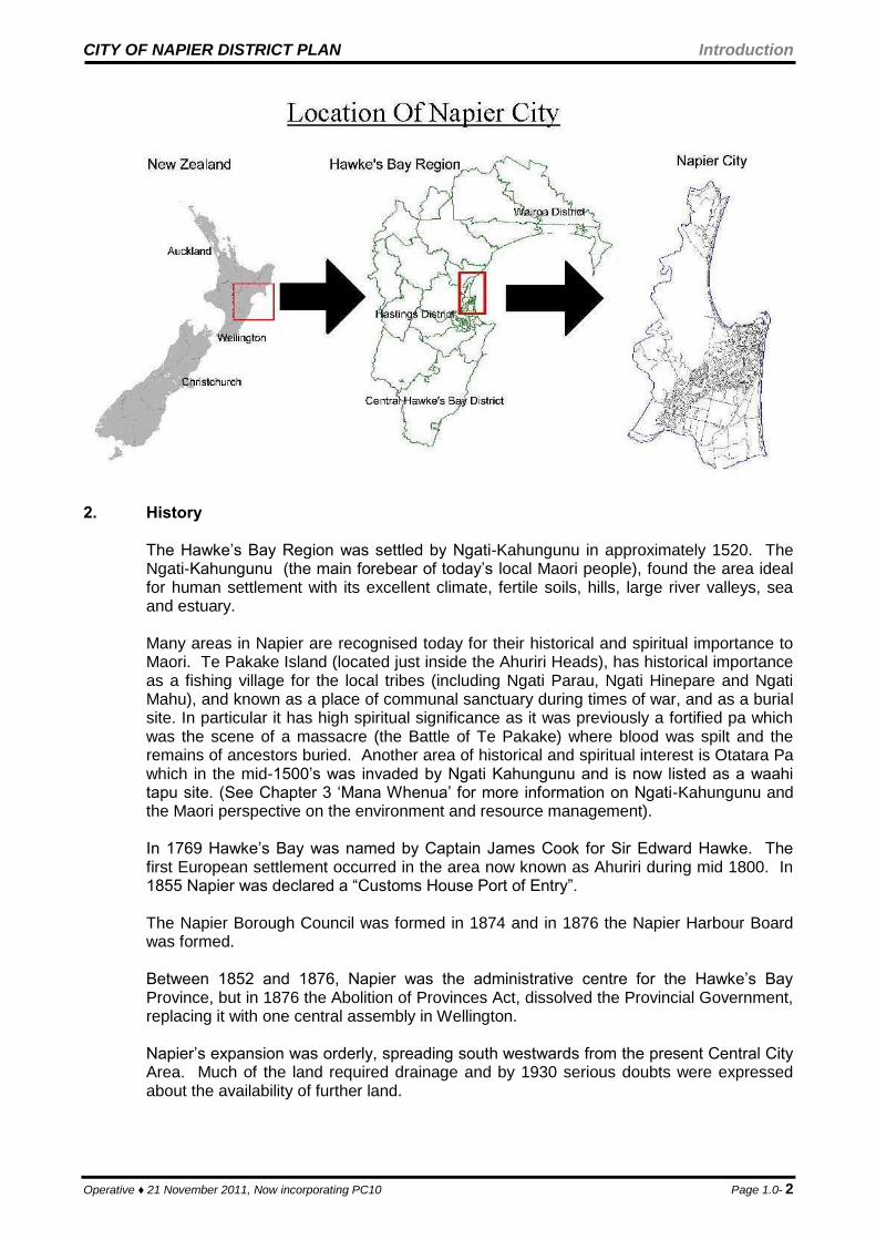
2. History The Hawke’s Bay Region was settled by Ngati-Kahungunu in approximately 1520. The Ngati-Kahungunu (the main forebear of today’s local Maori people), found the area ideal for human settlement with its excellent climate, fertile soils, hills, large river valleys, sea and estuary.
Many areas in Napier are recognised today for their historical and spiritual importance to Maori. Te Pakake Island (located just inside the Ahuriri Heads), has historical importance as a fishing village for the local tribes (including Ngati Parau, Ngati Hinepare and Ngati Mahu), and known as a place of communal sanctuary during times of war, and as a burial site. In particular it has high spiritual significance as it was previously a fortified pa which was the scene of a massacre (the Battle of Te Pakake) where blood was spilt and the remains of ancestors buried. Another area of historical and spiritual interest is Otatara Pa which in the mid-1500’s was invaded by Ngati Kahungunu and is now listed as a waahi tapu site. (See Chapter 3 ‘Mana Whenua’ for more information on Ngati-Kahungunu and the Maori perspective on the environment and resource management).
In 1769 Hawke’s Bay was named by Captain James Cook for Sir Edward Hawke. The first European settlement occurred in the area now known as Ahuriri during mid 1800. In 1855 Napier was declared a “Customs House Port of Entry”. The Napier Borough Council was formed in 1874 and in 1876 the Napier Harbour Board was formed. Between 1852 and 1876, Napier was the administrative centre for the Hawke’s Bay Province, but in 1876 the Abolition of Provinces Act, dissolved the Provincial Government, replacing it with one central assembly in Wellington. Napier’s expansion was orderly, spreading south westwards from the present Central City Area. Much of the land required drainage and by 1930 serious doubts were expressed about the availability of further land.

CITY OF NAPIER DISTRICT PLAN Introduction
Operative ♦ 21 November 2011, Now incorporating PC10 Page 1.0- 3
On 3 February 1931 a series of earthquakes struck Hawke’s Bay. This was followed by a disastrous fire which gutted the central area of Napier. Two hundred and fifty six people died, and damage to property exceeded [then] £5million. Two positive effects arose from the disaster. Firstly the wholesale destruction of the business area meant that in rebuilding the faults of the past could be avoided and secondly over 4,000 hectares of land which was formerly estuary were raised enabling the Borough to expand. The events of 1931 brought about special emergency planning regulations. In 1932 the first Town Plan was prepared under the Town Planning Act. As development continued the Council controlled expansion with a series of schemes, eg: Napier Marewa Scheme 1934, Napier Onekawa Scheme 1948. In 1968 the Taradale Borough was amalgamated with the City of Napier. A District Scheme was then prepared for the whole City and became operative on 26 July 1973. In 1989 Local Government Reorganisation added the rural areas of Bay View, Poraiti and Meeanee to the City.
3. The People
The population of Napier City is 55,500 (2002 Statistics NZ estimate). This is an increase of 2038 people from the 1996 Census figure. The rate of population growth of Napier City has slowed since the high population growth rates of the 1960’s and 70’s. Over the 1986 – 1991 period, population declined, mirroring the regional situation. The 1991-1996 period however, saw a 4.6% recovery in the City’s resident population. Napier has a higher percentage of its population in the over 65 age group than occurs nationally, 15.2% in 2001 as opposed to 12.1% for the national figure. The so called “working age” (15-65) population is around 62.5% of the total. This compares to 65.3% for New Zealand as a whole. The 2001 Census showed that 17% of the population of Napier City were of New Zealand Maori ethnicity. Napier’s population has been affected by variable migration. Napier experienced net out migration in the three inter-censal periods prior to 1991. This was reversed over 1991-2001. Council policy aims to attract migrants and retain younger people in its area. The population characteristics of the city have implications for a range of district plan issues, including: the type of environment, level of amenity and range of housing sought by residents.
4. Social and Economic Activity The historical development of the Napier economy has been based on activities occurring within the City itself and its role within the wider regional economy. In terms of the City, these have included its relatively small primary industries base, specialised manufacturing (e.g. food, textiles, timber, electronics and other activities), residential development, retailing, hospitality/tourism services, transport and business services, Government agencies and education. In terms of the region, the City's contribution relates to, in
CITY OF NAPIER DISTRICT PLAN Introduction
Operative ♦ 21 November 2011, Now incorporating PC10 Page 1.0- 4
particular, the visitor industry, the Port of Napier and Hawke’s Bay Airport, the processing of Hawke’s Bay primary production, service manufacturing in support of the rural sector and tertiary education. The importance of the Port is indicated by research identifying that it is associated with approximately 50% of the region's economy The main employing sectors in Napier include primary production processing, manufacturing of metal products, construction, wholesaling and retailing, community services, transport and communications, business services and education. Significant employment gains over the past three years have been recorded by agricultural services, construction, wholesaling and retailing, hospitality services, business services, education and community services. Napier's sector growth opportunities over the medium-term are considered to include further tourism development (Art Deco, wine, conferences, general tourism and international visitors), industries servicing the tourism sector (accommodation, attractions and hospitality), tertiary and international education, transport (especially the Port of Napier and Hawke’s Bay Airport), specialised manufacturing, wood processing and further residential development. The Napier City Council's long-term Vision for Napier is for the City to strengthen its position as the tourism, transport, administration, specialised manufacturing and retirement/lifestyle hub of the Hawke’s Bay region.
5. The Environment
Napier’s natural and physical environment is characterised by a high level of amenity. The City’s suburbs have been planned and even with substantial infill taking place, it is considered that the urban environment still exhibits a high level of amenity. Napier has a low scale built environment and it is the Council’s intention that the scale of the City is maintained.
The built heritage is of primary importance to the City and the Council recognises that it plays a more important role than just a link to the past. Heritage also includes aspects of, archaeological, spiritual, social traditional or other special cultural significance. It has already been stated that the City has a direct relationship with the regional economy, an economy that is linked to primary production. The Council recognises this through the sustainable management of the highly versatile soils within the area. Other rural areas of the City provide for rural lifestyles and form an important backdrop to the City.
The Ahuriri Estuary and wetlands is a natural resource of national significance. It has an abundance of wildlife and is a valuable ecological area. The foreshore is an important focus for the City and provides important recreation and conservation areas. The foreshore reserves are utilised by many people who enjoy the recreational resource.
CITY OF NAPIER DISTRICT PLAN Introduction
Operative ♦ 21 November 2011, Now incorporating PC10 Page 1.0- 5
1.3 STATUTORY FRAMEWORK 1. Functions of Territorial Authorities under the Act
The functions of the Napier City Council are set out in Section 31 of the Resource Management Act:
“Every territorial authority shall have the following functions for the purpose of giving effect to this Act in its district:
(a) The establishment, implementation and review of objectives, policies and methods to achieve integrated management of the effects of the use, development or protection of land and associated natural and physical resources of the district.
(b) The control of any actual or potential effects of the use, development, or protection of
land, including the implementation of rules for the avoidance or mitigation of natural hazards and the prevention and mitigation of any adverse effects of the storage, use, disposal, or transportation of hazardous substances.
(c) The control of the subdivision of land; (d) The control of the emission of noise and the mitigation of the effects of noise; (e) The control of any actual or potential effects of activities in relation to the surface of
water in rivers and lakes; (f) Any other functions specified in the Act.”
2. Contents of the District Plan
Section 75(1) of the Act sets out the matters to be included within the District Plan:
“(1) A district plan shall make provision for such of the matters set out in Part II of the Second
Schedule as are appropriate to the circumstances of the district and shall state:
(a)The significant resource management issues of the district; and
(b)The objectives sought to be achieved by the plan; and
(c)The policies in regard to the issues and objectives, and an explanation of those policies; and
(d)The methods being or to be used to implement the policies, including any rules; and
(e)The principal reasons for adopting the objectives, policies, and methods of implementation set out in the plan; and
(f)The information to be submitted with an application for a resource consent, including the circumstances in which the powers under Section 92 of the Act may be used; and
(g)The environmental results anticipated from the implementation of these policies and methods; and
(h)The processes to be used to deal with issues which cross territorial boundaries; and
(i)The procedures to be used to review the matters set out in paragraphs a) to h), and to monitor the effectiveness of the plan as a means of achieving its objectives and policies; and
(j)Any other information that the territorial authority considers appropriate; and
(k)Such additional matters as may be appropriate for the purpose of fulfilling the territorial authority's functions, powers and duties under this Act.”
The resource management issues are discussed in each Chapter of this Plan. These have been identified through a public consultation process.
The emphasis within this District Plan is on the effects of activities, together with the use and development of land. In this Plan, the means of achieving the desired environmental outcome is based on determining the effects a land use will have on the environment. As
CITY OF NAPIER DISTRICT PLAN Introduction
Operative ♦ 21 November 2011, Now incorporating PC10 Page 1.0- 6
the desired outcomes vary within the City, performance zones are used to identify acceptable levels of effects within each zone.
3. Principles and Purposes
The Act identifies principles to be adopted in achieving its purpose by all persons exercising its management functions and powers. These are outlined in Part II of the Act, the Purpose and Principles and is detailed in Appendix 1 of this Plan. The Act promotes the sustainable management of natural and physical resources and requires local communities to identify the means by which sustainable management is promoted. The Act requires the Council to recognise and provide for the matters of national importance set out under section 6 and have particular regard to the other matters in section 7 of the Act in exercising its functions and powers. These matters are provided for in the appropriate environments in this Plan. Treaty of Waitangi responsibilities, kaitiakitanga, the ethic of stewardship, and the relationship of Maori and their culture and traditions with their ancestral lands, water, sites, waahi tapu , and other taonga and recognised and provided for in the Manawhenua, Heritage, and other Chapters of this Plan.
Part II of the Second Schedule to the Act is important because it lists the matters related to the district that may be provided for in the District Plan.
CITY OF NAPIER DISTRICT PLAN Introduction
Operative ♦ 21 November 2011, Now incorporating PC10 Page 1.0- 7
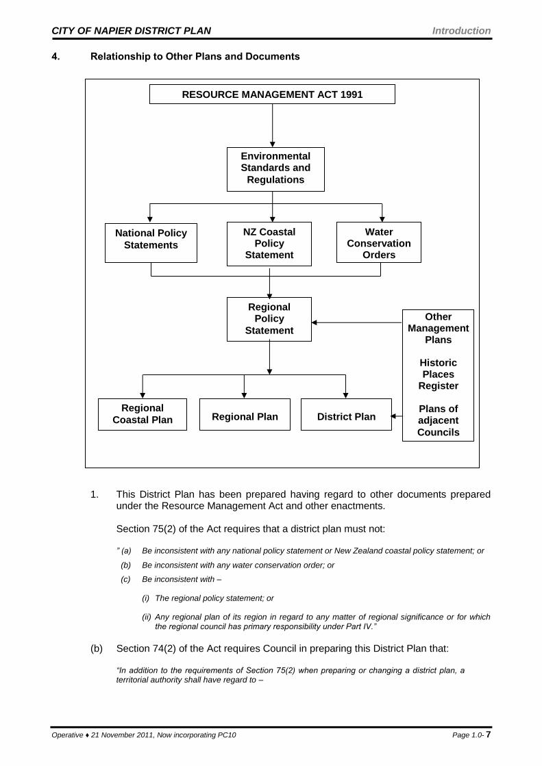
4. Relationship to Other Plans and Documents
1. This District Plan has been prepared having regard to other documents prepared under the Resource Management Act and other enactments.
Section 75(2) of the Act requires that a district plan must not:
” (a) Be inconsistent with any national policy statement or New Zealand coastal policy statement; or
(b) Be inconsistent with any water conservation order; or
(c) Be inconsistent with –
(i) The regional policy statement; or (ii) Any regional plan of its region in regard to any matter of regional significance or for which
the regional council has primary responsibility under Part IV.”
(b) Section 74(2) of the Act requires Council in preparing this District Plan that:
“In addition to the requirements of Section 75(2) when preparing or changing a district plan, a territorial authority shall have regard to –
RESOURCE MANAGEMENT ACT 1991
Environmental Standards and
Regulations
National Policy
Statements
NZ Coastal Policy
Statement
Water Conservation
Orders
Regional Policy
Statement
Regional
Coastal Plan
Regional Plan
District Plan
Other Management
Plans
Historic Places
Register
Plans of adjacent
Councils

CITY OF NAPIER DISTRICT PLAN Introduction
Operative ♦ 21 November 2011, Now incorporating PC10 Page 1.0- 8
(a) Any -
(i) Proposed regional policy statement; or
(ii) Proposed regional plan of its region in regard to any matter of regional significance or for which the regional council has primary responsibility under Part IV; and
(b) Any -
(i) Management plans and strategies prepared under other Acts; and
(ii) Relevant planning document recognised by an iwi authority affected by the district plan; and
(iia) Relevant entry in the Historic Places Trust Register; and
(iii) Regulations relating to ensuring sustainability or the conservation, management, or sustainability of fisheries resources (including regulations, or bylaws relating to taiapure, mahinga mataitai, other non-commercial Maori customary fishing),
to the extent that their content has a bearing on resource management issues of the district; and
(c) The extent to which the district plan needs to be consistent with the plans or proposed plans of adjacent territorial authorities.”
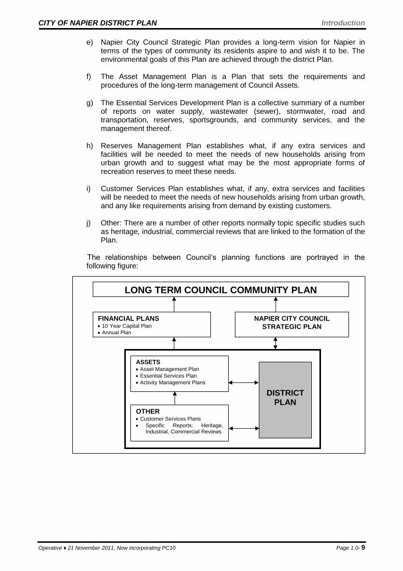
2. The district plan also has important relationships with other planning functions
undertaken by the Council. The environmental goals that Council sets in its strategic planning documents are achieved through the district plan. There are strong environmental links between the Council’s financial and asset management roles as these two areas play an important role in the sustainable management of the City’s natural and physical resources. Each year any policies or methods that require financial resources to implement them must be costed and prioritised through the Annual Plan process.
Along side national and regional Plans the District Plan also has a direct relationship with many other Council documents. The following is a brief explanation of the purpose of each document and how it relates to the district Plan.
a) The Long Term Council Community Plan (LTCCP) is prepared under the Local
Government Act 2002 and is a comprehensive statement of what the Council does and what it intends to be doing in the future. It is designed to ensure integrated decision making and co-ordination of resources of the Council. It also provides an opportunity for participation by the public in decision making processes on activities to be undertaken by the Council. This Plan is reviewed every three years and has a planning horizon of not less than 10 years.
b) The Annual Plan sets out the budget allocation for Council activities in each
financial year. Each year any policies or methods in the District Plan which require financial resources to implement them must be costed and prioritised through the Annual Plan process. (Note: The Annual Plan is not produced in the year the LTCCP is reviewed as it forms part of the LTCCP in that year).
c) The Long Term Financial Strategy provides the financial requirements of the
Council for the ten year period 1998/99 to 2007/08.
d) The 10 Year Capital Plan forms part of the Annual Plan and sets out the capital
works proposed to be undertaken within at least the next 10 years. Such works involve urban development, infrastructural asset renewal, special projects such as hall upgrades and community facilities, and roading projects.
CITY OF NAPIER DISTRICT PLAN Introduction
Operative ♦ 21 November 2011, Now incorporating PC10 Page 1.0- 9
e) Napier City Council Strategic Plan provides a long-term vision for Napier in terms of the types of community its residents aspire to and wish it to be. The environmental goals of this Plan are achieved through the district Plan.
f) The Asset Management Plan is a Plan that sets the requirements and
procedures of the long-term management of Council Assets.
g) The Essential Services Development Plan is a collective summary of a number
of reports on water supply, wastewater (sewer), stormwater, road and transportation, reserves, sportsgrounds, and community services, and the management thereof.
h) Reserves Management Plan establishes what, if any extra services and
facilities will be needed to meet the needs of new households arising from urban growth and to suggest what may be the most appropriate forms of recreation reserves to meet these needs.
i) Customer Services Plan establishes what, if any, extra services and facilities
will be needed to meet the needs of new households arising from urban growth, and any like requirements arising from demand by existing customers.
j) Other: There are a number of other reports normally topic specific studies such
as heritage, industrial, commercial reviews that are linked to the formation of the Plan.
The relationships between Council’s planning functions are portrayed in the following figure:
LONG TERM COUNCIL COMMUNITY PLAN
FINANCIAL PLANS 10 Year Capital Plan
Annual Plan
NAPIER CITY COUNCIL
STRATEGIC PLAN
ASSETS Asset Management Plan
Essential Services Plan
Activity Management Plans
OTHER Customer Services Plans
Specific Reports: Heritage, Industrial, Commercial Reviews
DISTRICT PLAN

CITY OF NAPIER DISTRICT PLAN Introduction
Operative ♦ 21 November 2011, Now incorporating PC10 Page 1.0- 10
1.4 MEANS OF ACHIEVING ENVIRONMENTAL OUTCOMES
Traditionally, achieving an environmental outcome has been handled by means of regulation. The Resource Management Act 1991 requires investigation of other means of achieving environmental outcomes. Changes in local government legislation and practice have required that local authorities be more accountable to the public and oriented towards greater service delivery. This has brought about the introduction of Annual Plans, which set out the Council's commitments for the next financial year and its indicative spending for two years beyond that. The linking of the Annual Plan to the District Plan is necessary as the Resource Management Act has a more defined purpose than the Town and Country Planning Act and does not have the scope to initiate policy other than that which works towards the sustainable management of natural and physical resources. Broader issues relating to economic development or City improvements, for example, are more appropriately handled through the Annual Plan process where a level of financial commitment is available and implementation is assured. The District Plan may identify where economic development or physical improvement measures are necessary but the financial commitment or implementation will be achieved through the Annual Plan process. Some form of regulation is considered to be necessary although the level of intervention can vary significantly. It is possible to categorise foreseeable land uses - for example, as a discretionary or controlled activities - and direct where they are appropriate. However this is removed from the intent of the Act which is to concentrate on outputs or effects. The method chosen by this Council is to acknowledge that there are parts of the City where effects of land uses are going to have a different level of impact, and this is reflected in the conditions imposed. The result is that boundaries have been drawn around areas where certain levels of performance are required - this is known as a performance zone. The principal reasons for using performance zones are: (a) The emphasis of the Resource Management Act 1991 is on managing the effects on
the environment;
(b) It is necessary to recognise that existing zones do segregate activities and performance standards are expected by landowners and occupiers; and
(c) Natural and physical features vary throughout the City, with different effects of activities being experienced.
The use of performance zones can be supported by a range of other methods - these may include codes of practice; design guides; and financial instruments such as levies and rates relief.
CITY OF NAPIER DISTRICT PLAN Introduction
Operative ♦ 21 November 2011, Now incorporating PC10 Page 1.0- 11
1.5 HOW TO USE THE PLAN
1. Plan Arrangement The City of Napier District Plan is comprised of three volumes. Volume I contains the bulk of the planning information. It is this document that contains the introductory chapters, significant resource management issues, objectives, policies and methods used to address the identified issues, the anticipated environmental results arising from the management of land uses in accordance with the objectives, policies and methods, and lastly the appendices. Volume II contains Parts A, B and C of the Code of Practice for Subdivision and Land Development, otherwise referred to as Chapter 66. Volume III (A3 size document) contains the planning maps and associated key sheets. Volume I
This document containing the bulk of the planning information is structured into 10 parts as follows:
Part 1 Introduction, Sustainable Management Strategy and Manawhenua Part 2 Residential Environments Part 3 Commercial Environments Part 4 Industrial Environments Part 5 Rural Environments Part 6 Open Space Environments Part 7 Other Zones Part 8 District Wide Rules Part 9 Definitions Part 10 Appendices
Parts 1 – 8 generally contain the following:
Significant Resource Management Issues These are applicable to the type of environment and/or particular type of land use throughout the City and have been based on feedback from the Napier community. Objectives These relate to what the Napier community wants to achieve in relation to a particular resource management issue. Policies These are actions that the Council will undertake to achieve the relevant objective. Methods These are the tools or techniques that will be used to achieve the desired objective. Principal Reasons The predominant reasons for the objective and policies are explained as well as an outline of the principal reasons for adopting the methods. Anticipated Environmental Results Represent practical results the Napier community could expect to see as a result of this Plan.
CITY OF NAPIER DISTRICT PLAN Introduction
Operative ♦ 21 November 2011, Now incorporating PC10 Page 1.0- 12
Assessment Criteria At the end of each of the Environments, Airport and Tertiary Education Zones and District Wide Rule Chapters, criteria to assist in the assessment of resource consent applications for restricted discretionary and discretionary activities is provided. Principal Reasons For Rules These are also found at the end of each of the Environments, Airport and Tertiary Education Zones and District Wide Rule Chapters. Here, a concise explanation of the principal reasons for adopting a particular rule is provided. Part 8 also contains monitoring and review procedures, particularly in relation to resource consents and monitoring the effectiveness of this Plan. Part 9 includes interpretations of words and terms included within the Plan. It gives meanings of words and terms to aid interpretation. Words and terms defined within the Resource Management Act 1991 and its subsequent amendments are not included within this Chapter but for the purposes of this shall be deemed to have the same meaning as in the Act. Part 10 includes appendices that provide information for the further interpretation of objectives, policies, methods and rules. The appendices may include conditions, standards, terms, tables, diagrams, plans, schedules, and criteria.
Volume II This volume of the Plan contains Chapter 66. Due to its likely use, administration and bulk, it is bound as a separate volume. It contains Parts A, B and C of the Code of Practice for Subdivision and Land Development (the Code). Part A of the Code sets out the resource management requirements for land development and subdivision within Napier City in terms of the Council’s powers and duties under the Act. The requirements are set out in the following manner:
Background – including the purpose and powers of the Plan; Scope of the Code; Land Development resource issues; Management Strategy for land development; Rules for subdivision and land development; Subdivision consent application procedures and requirements; Land development proposals, procedures and requirements.
Part B of the Code defines criteria which are required to be complied with to achieve an acceptable minimum level of performance for all land and infrastructure development subject to consents under the Act, the Plan or any other Council approvals in accordance with bylaws, or empowering legislation. Part C of the Code sets out engineering and other standards for subdivisions and land development works (whether or not the latter are associated with the former). This part is divided into those sections of a general nature and then into sections relating to individual utilities or services.
CITY OF NAPIER DISTRICT PLAN Introduction
Operative ♦ 21 November 2011, Now incorporating PC10 Page 1.0- 13
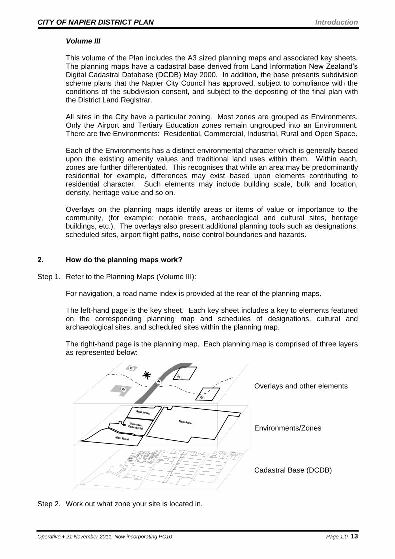
Volume III This volume of the Plan includes the A3 sized planning maps and associated key sheets. The planning maps have a cadastral base derived from Land Information New Zealand’s Digital Cadastral Database (DCDB) May 2000. In addition, the base presents subdivision scheme plans that the Napier City Council has approved, subject to compliance with the conditions of the subdivision consent, and subject to the depositing of the final plan with the District Land Registrar. All sites in the City have a particular zoning. Most zones are grouped as Environments. Only the Airport and Tertiary Education zones remain ungrouped into an Environment. There are five Environments: Residential, Commercial, Industrial, Rural and Open Space. Each of the Environments has a distinct environmental character which is generally based upon the existing amenity values and traditional land uses within them. Within each, zones are further differentiated. This recognises that while an area may be predominantly residential for example, differences may exist based upon elements contributing to residential character. Such elements may include building scale, bulk and location, density, heritage value and so on. Overlays on the planning maps identify areas or items of value or importance to the community, (for example: notable trees, archaeological and cultural sites, heritage buildings, etc.). The overlays also present additional planning tools such as designations, scheduled sites, airport flight paths, noise control boundaries and hazards.
2. How do the planning maps work? Step 1. Refer to the Planning Maps (Volume III): For navigation, a road name index is provided at the rear of the planning maps.
The left-hand page is the key sheet. Each key sheet includes a key to elements featured on the corresponding planning map and schedules of designations, cultural and archaeological sites, and scheduled sites within the planning map. The right-hand page is the planning map. Each planning map is comprised of three layers as represented below:
Overlays and other elements Environments/Zones Cadastral Base (DCDB) Step 2. Work out what zone your site is located in.
CITY OF NAPIER DISTRICT PLAN Introduction
Operative ♦ 21 November 2011, Now incorporating PC10 Page 1.0- 14
Step 3. Are there any special notations or overlays on or adjacent to your site?
Overlay Where in Plan Overlay Where in Plan
Advocacy Area Ch 56 (Heritage) Heritage Appendix 13 Ch(Heritage)
Building Line Restriction (BLR) Appendix 6 Noise Control Boundary Relevant zone
Cultural and Archaeological Sites
Key Sheets, Ch 56 (Heritage)
Notable Tree Ch 60 (Trees)
Areas of Significance to Maori Ch 56 (Heritage) Scheduled Site Key Sheet Ch55 (Sched. Sites)
Designation Key Sheets
Proposed Closed Road Planning maps. Coastal Hazard Key Sheets Ch 62 (Natural Haz)
Structure Plan Appendices 26 - 30
3. How do I read the rules? Step 1. Having noted what zone your site is located in and any relevant overlays, refer to the
applicable chapter(s) containing the rules for that particular zone and any overlay(s).
From locating your site on the Planning Maps refer to the relevant chapter that contains the rules for your zone. If your site has an overlay, also refer to the relevant district wide rules and/or diagrams. If there is a conflict between the rules of the zone and the district wide rules, the district wide rules have precedence.
NOTE: The rules for the overlays have precedence over the rules in any other Chapter. Where there is conflict, the overlay rules shall apply.
Step 2. Determine what your land use/activity involves and what terminology applies (reference to
Chapter 68 (Definitions) will assist with this).
NOTE: Some land uses may also involve subdivision of land; multi-unit development; network utilities; construction or relocation of buildings; signs; earthworks (includes excavations and filling); hazardous substances; sale of liquor; etc.
Step 3. A summary table is provided to concisely summarise the zone’s activity table elsewhere in
the respective Chapter and can be used as a quick reference tool. An example of the rule summary table structure is provided below:
Rule Number and Description of Land Use Heading
(examples used are purely fictitious).
Activity Classification
Page Number of Plan
Rule 1.1 Kangaroo Farming. Permitted 12
Rule 1.2 Giraffe Farming. Controlled 34
Rule 1.3 Kangaroo Farming and Giraffe Farming that does not comply with all the relevant conditions.
Restricted Discretionary
56
Rule 1.4 Kangaroo farming involving the keeping of more than 10 kangaroos. Discretionary 78
Rule 1.5 Lion farming Non-Complying
Activity
85
Rule 1.6 Crocodile Farming. Prohibited 90
Step 4. Note what the relevant rule number(s) is and on what page the rule can be found within
the Plan. Step 5. Refer to the zone’s activity table to discover what conditions are applicable (if any). The
CITY OF NAPIER DISTRICT PLAN Introduction
Operative ♦ 21 November 2011, Now incorporating PC10 Page 1.0- 15
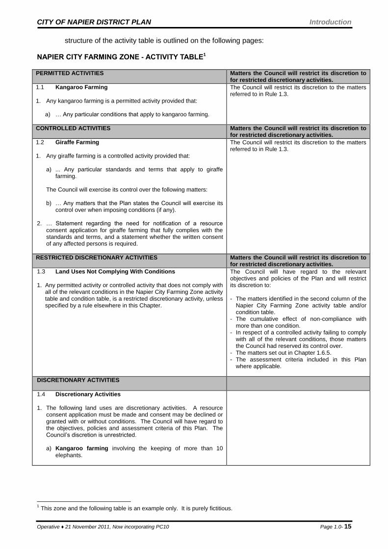
structure of the activity table is outlined on the following pages: NAPIER CITY FARMING ZONE - ACTIVITY TABLE1 PERMITTED ACTIVITIES Matters the Council will restrict its discretion to
for restricted discretionary activities.
1.1 Kangaroo Farming
1. Any kangaroo farming is a permitted activity provided that:
a) … Any particular conditions that apply to kangaroo farming.
The Council will restrict its discretion to the matters referred to in Rule 1.3.
CONTROLLED ACTIVITIES
Matters the Council will restrict its discretion to for restricted discretionary activities.
1.2 Giraffe Farming
1. Any giraffe farming is a controlled activity provided that:
a) ... Any particular standards and terms that apply to giraffe farming.
The Council will exercise its control over the following matters: b) … Any matters that the Plan states the Council will exercise its
control over when imposing conditions (if any).
2. … Statement regarding the need for notification of a resource consent application for giraffe farming that fully complies with the standards and terms, and a statement whether the written consent of any affected persons is required.
The Council will restrict its discretion to the matters referred to in Rule 1.3.
RESTRICTED DISCRETIONARY ACTIVITIES Matters the Council will restrict its discretion to for restricted discretionary activities.
1.3 Land Uses Not Complying With Conditions
1. Any permitted activity or controlled activity that does not comply with
all of the relevant conditions in the Napier City Farming Zone activity table and condition table, is a restricted discretionary activity, unless specified by a rule elsewhere in this Chapter.
The Council will have regard to the relevant objectives and policies of the Plan and will restrict its discretion to: - The matters identified in the second column of the
Napier City Farming Zone activity table and/or condition table.
- The cumulative effect of non-compliance with more than one condition.
- In respect of a controlled activity failing to comply with all of the relevant conditions, those matters the Council had reserved its control over.
- The matters set out in Chapter 1.6.5. - The assessment criteria included in this Plan
where applicable.
DISCRETIONARY ACTIVITIES
1.4 Discretionary Activities
1. The following land uses are discretionary activities. A resource
consent application must be made and consent may be declined or granted with or without conditions. The Council will have regard to the objectives, policies and assessment criteria of this Plan. The Council’s discretion is unrestricted.
a) Kangaroo farming involving the keeping of more than 10
elephants.
1 This zone and the following table is an example only. It is purely fictitious.

CITY OF NAPIER DISTRICT PLAN Introduction
Operative ♦ 21 November 2011, Now incorporating PC10 Page 1.0- 16
NON-COMPLYING ACTIVITIES
1.5 Non-Complying Activities
1. The following are non-complying activities.
a) Lion farming
PROHIBITED ACTIVITIES
1.6 Prohibited Activities
1. The following land uses are a prohibited activity for which no
resource consent shall be granted:
a) Crocodile farming.
Step 5 (Cont’) NOTE: Where there is an inconsistency between two or more rules, the more stringent rule shall apply.
Step 6. Do you need a resource consent? (The rule summary tables in the first instance and
secondly the activity tables and condition tables, will assist with this question).
Step 7. Having determined what classification your land use is, either:
a) For a permitted activity, no resource consent is required however, requirements of
other legislation may apply, (for example: Building Act 1991). b) For a controlled activity, a resource consent is required. In granting consent,
conditions may be applied by the Council, but only in respect of the matters that the Plan states Council shall exercise its control over. Refer to Chapter 1.6.3 for a fuller explanation of the activity classification. Chapter 1.8 outlines information requirements and other relevant advice relating to applications for resource consents.
c) For a restricted discretionary activity, a resource consent is required. The Council
may decline or grant consent with or without conditions relating to the specific matters over which the Council has restricted its discretion. These matters can generally be
No No No Yes Yes Yes No No Yes Yes
Is land use classified as
a Prohibited Activity?
Land use is a Restricted Discretionary Activity,
unless a rule in the Plan states otherwise.
Is land use classified as
a Controlled Activity?
Land use is a Prohibited
Activity. No resource consent
will be granted.
Is land use classified as
a Permitted Activity?
Land use is either a Restricted Discretionary
Activity, Discretionary Activity or
Non-Complying Activity.
Land use is a Controlled
Activity. A resource consent is
required.
Land use is a Permitted
Activity. No resource consent is
required.
Does land use comply with all rules and
conditions?
Does land use comply with all rules and
standards and terms?
Land use is a Restricted
Discretionary Activity. A resource consent is
required.
Land use is a Restricted Discretionary Activity,
Discretionary Activity or Non-Complying Activity.
A resource consent is
required.
START HERE
CITY OF NAPIER DISTRICT PLAN Introduction
Operative ♦ 21 November 2011, Now incorporating PC10 Page 1.0- 17
found in the second column of the activity tables and condition tables. Refer to Chapter 1.6.5 for a fuller explanation of the activity classification. Chapter 1.8 outlines information requirements and other relevant advice relating to applications for resource consents.
d) For a discretionary activity, a resource consent is required. The Council may decline
or grant consent with or without conditions. In declining or granting consent, the Council’s discretion is unrestricted. Refer to Chapter 1.6.4 for a fuller explanation of the activity classification. Chapter 1.8 outlines information requirements and other relevant advice relating to applications for resource consents.
e) For a non-complying activity, a resource consent is required. Council has discretion
to grant or refuse consent, but must refuse consent unless it is satisfied that the adverse effects on the environment will be minor, or granting the consent will not be contrary to the Objectives and Policies of the District Plan. Refer to Chapter 1.6.6 for a fuller explanation of the activity classification. Chapter 1.8 outlines information requirements and other relevant advice relating to applications for resource consents.
f) For a prohibited activity, no resource consent shall be granted. Refer to Chapter
1.6.6 for a fuller explanation of the activity classification and other relevant advice.
4. Where can I get further information? Further advice can be obtained from planning officers at the Napier City Council. The
Planning Department can be contacted at:
Location: 2nd Floor, Library Building Station Street, NAPIER Office Hours: Mon – Fri (8:00am – 5:00pm) Postal: Private Bag 6010 NAPIER Telephone: (06) 835-7579 Facsimile: (06) 835-7574 Email: [email protected]
1.6 TYPES OF RESOURCE CONSENTS
Every resource consent application that is required by this Plan or in accordance with the Act must follow the procedure set out in the Act, and outlined below. All applications for a resource consent must provide an assessment of any actual or potential effects and the assessment is to be prepared in accordance with the Fourth Schedule of the Act and any additional criteria set down under each activity classification.
1. Assumptions for Activity Status This Plan has a written presumption in most zones that any land uses that are not classified as prohibited, controlled, restricted discretionary, or discretionary and that comply with all the relevant conditions are deemed to be permitted activities. In some very sensitive environments the presumption is that land uses that are not identified in the
CITY OF NAPIER DISTRICT PLAN Introduction
Operative ♦ 21 November 2011, Now incorporating PC10 Page 1.0- 18
Plan will be discretionary activities. These presumptions reflect the permissive philosophy of the Act, however as previously stated there are some parts of the City where a permissive presumption may not adequately ensure the sustainable management of natural and physical resources, including the avoidance, remediation or mitigation of adverse effects on the environment. These are in areas that are environmentally sensitive or in the case of the residential environment where residents expect a level of certainty as to the type of land use that can locate there. The Council has included the non-complying activity class to provide a clear indication that the activity is only appropriate in the zone in exceptional circumstance and that conditions may be placed on any consent.
2. Permitted Activities A permitted activity means a land use that is allowed by a plan or proposed plan without a resource consent if it complies in all respects with all the conditions specified in a plan or proposed plan for that land use. A resource consent application is not required.
3. Controlled Activities
A controlled activity means an activity that must:
a) Be provided for as a controlled activity by a rule in a plan or proposed plan; b) Comply with standards and terms specified for that land use in a plan or proposed
plan; c) Be assessed according to matters the consent authority has reserved control over in
the plan or proposed plan; d) Be approved but only if a resource consent application is made in respect of that
land use.
A resource consent application for a controlled activity need not be publicly notified in accordance with Section 93 of the Act except where:
a) The applicant requests notification; or
b) Special circumstances exist under Section 94C of the Act. Council however, under Section 94 of the Act, must serve notice of an application on all persons who in the opinion of the Council may be adversely affected by the activity, unless:
a) All persons who, in the opinion of the Council may be adversely affected by the
activity, have given their written approval to the activity; or b) A rule in a Plan or Proposed Plan expressly provides that notice of such
applications does not need to be served.
4. Discretionary Activities A discretionary activity means an activity which is provided for as a discretionary activity
CITY OF NAPIER DISTRICT PLAN Introduction
Operative ♦ 21 November 2011, Now incorporating PC10 Page 1.0- 19
by a rule in a plan or proposed plan; and
a) Which is allowed only if a resource consent is obtained in respect of that land use; & b) Which may have standards and terms specified in a plan or proposed plan; and c) In respect of which the Council may restrict the exercise of its discretion to those
matters specified in a plan or proposed plan for that land use.
A resource consent application for a discretionary activity need not be publicly notified in accordance with Section 93 of the Act except where:
a) The Council is satisfied that the adverse effects of the activity on the environment will be more than minor; or
b) The applicant requests notification; or c) Special circumstances exist under Section 94C of the Act.
Council however, under Section 94 of the Act, must serve notice of an application on all persons who in the opinion of the Council may be adversely affected by the activity, unless all persons who, in the opinion of the Council may be adversely affected by the activity have given their written approval to the activity.
5. Restricted Discretionary Activities Some discretionary activity rules state that discretion is restricted. In these cases, Council’s ability to refuse consent, or impose conditions, is restricted to the matters over which it has retained a discretion. These matters are also relevant to the assessment of environmental effects to be supplied by the applicant for a resource consent. For restricted discretionary activities in the ‘matters column’, a statement or list of matters to which discretion is restricted is provided. This list identifies the matters Council will consider only in terms of the condition(s) that are not met, but does not include an opportunity to consider those matters in relation to any condition(s) that are complied with. The matters listed below are additional matters applicable to every restricted discretionary activity. They are stated here, rather than repeated in rule tables in order to conserve space. Additional matters to which discretion is restricted:
a) Financial contributions in the form of money or land or a combination of both. (Refer to Chapter 65).
b) Bonds or covenants or both, to ensure performance or compliance with any
conditions imposed. c) Works or services to ensure the protection, restoration or enhancement of any
natural or physical resource, including (but not limited to) planting or replanting, earthworks, or any other works or services necessary to ensure the avoidance, remediation or mitigation of adverse environmental effects.
d) Administrative charges to be paid to the Council in respect of processing
applications, administration, monitoring and supervision of resource consents, and for the carrying out of Council’s functions under Section 35 of the Act.
CITY OF NAPIER DISTRICT PLAN Introduction
Operative ♦ 21 November 2011, Now incorporating PC10 Page 1.0- 20
e) The duration of a resource consent, under Section 123 of the Act. f) Lapsing of a resource consent, under Section 125 of the Act. g) Change and cancellation of a consent, under Sections 126 and 127 of the Act. h) Notice that some or all of the conditions may be reviewed at some time in the future,
under Section 128 of the Act. A resource consent application for a restricted discretionary activity need not be publicly notified in accordance with Section 93 of the Act except where:
a) The Council is satisfied that the adverse effects of the activity on the environment will be more than minor; or
b) The applicant requests notification; or c) Special circumstances exist under Section 94C of the Act.
Council however, under Section 94 of the Act, must serve notice of an application on all persons who in the opinion of the Council may be adversely affected by the activity, unless:
a) All persons who, in the opinion of the Council may be adversely affected by the
activity, have given their written approval to the activity; or
b) A rule in a Plan or Proposed Plan expressly provides that notice of such applications does not need to be served.
6. Non-Complying Activities
A non-complying activity is an activity that does not comply with the conditions and rules in the Plan, or is specifically listed as a non-complying activity. Council has discretion to grant or refuse consent, but must refuse consent unless it is satisfied that the adverse effects on the environment will be minor, or granting the consent will not be contrary to the Objectives and Policies of the District Plan. The listing of an activity as a Non-Complying Activity is a clear indication that the activity is only appropriate in the zone in exceptional circumstances. Conditions may be placed on any consent.
7. Prohibited Activities
A prohibited activity means a land use which a plan or proposed plan expressly prohibits and describes a land use for which no application shall be made and no resource consent shall be granted.
1.7 WRITTEN CONSENTS & NOTIFICATION (Discretionary Activities) The following is a guideline only to assist applicants and interested parties. (a) For restricted discretionary activity applications seeking resource consent in respect
of the following matters, applications will generally not be publicly notified if the written consent of the owners of adjoining and adjacent sites are submitted.

CITY OF NAPIER DISTRICT PLAN Introduction
Operative ♦ 21 November 2011, Now incorporating PC10 Page 1.0- 21
building height.
height in relation to boundary.
yards.
privacy and amenity.
Vehicle parking, access and manoeuvring.
site coverage.
open space.
Residential care facilities, day care centres and health care centres exceeding the numerical limit of people they are providing for.
Any aerial, line or support structure not complying with the conditions, including any aerial, line or support structure for the purposes of a network utility operation.
(b) For discretionary activity applications seeking resource consent in respect of the
following matters, applications need not be publicly notified, if the Council is satisfied that the adverse effects of the activity will be minor and the written consents of affected persons are submitted .
Land development not meeting the standards and terms.
Places of assembly.
Education facilities not established by a requiring authority.
Minor alteration of a heritage item. 1. Affected Parties
In forming an opinion as to who may be adversely affected by the activity, Council will consider the matters within Section 94B of the Act, which requires that the Council:
(a) Have regard to every relevant statutory acknowledgement, within the meaning of an Act specified in Schedule 11 of the RMA.
(b) Consider that a person may be treated as not being adversely affected if, in relation
to the adverse effects of the activity on the person, the plan permits an activity with that effect; or
(c) Consider that a person in relation to a controlled or restricted discretionary activity,
must not be treated as being adversely affected, if the adverse effects of the activity on the environment do not relate to a matter specified in the Plan or Proposed Plan as a matter for which-
(i) Control is reserved for the activity; or (ii) Discretion is restricted for the activity; or
(d) Consider that a person must not be treated as being adversely affected if it is unreasonable in the circumstances to seek the written approval of that person.
In addition to the above principal requirements, Council will also, in forming an opinion as to who may be adversely affected, consider the Plan’s objectives and policies and the principal reasons for the rules, and the effect that the application would have on:
CITY OF NAPIER DISTRICT PLAN Introduction
Operative ♦ 21 November 2011, Now incorporating PC10 Page 1.0- 22
(a) Those people living adjacent to or near to the site of the application.
(b) Those persons who own or lease land adjacent to or near to the site of the application and whose use of that land could be detrimentally affected by that application.
(c) Tangata whenua.
(d) Those persons or organisations whose use or enjoyment of an area could be adversely affected by any application.
(e) Any Minister of the Crown with statutory responsibilities in respect of the application site or any adjoining or adjacent site.
(f) The Hawke’s Bay Regional Council.
(g) Heritage New Zealand, in respect of places that have been identified as having heritage significance.
(h) New Zealand Transport Agency in respect of all matters impacting on the State Highway network.
(i) Transpower New Zealand Limited, in respect of land development (including subdivision) within 20 metres of a high voltage transmission line.
(j) Any other person or body whom the Council considers relevant in the circumstances.
2. Assessment of Effects on the Environment Under the Resource Management Act, the Council is required to assess an application for
the use, development and protection of natural and physical resources in terms of the effects on the environment. The Act gives the definition of "environment" and "effects".
CITY OF NAPIER DISTRICT PLAN Introduction
Operative ♦ 21 November 2011, Now incorporating PC10 Page 1.0- 23
“"Environment" includes:
(a) Ecosystems and their constituent parts, including people and their communities; and
(b) All natural and physical resources; and
(c) Amenity values; and
(d) The social, economic, aesthetic and cultural conditions which affect the matters stated in paragraphs (a) to (c) of this definition or which are affected by those matters.”
The term "effects" includes:
“(a) Any positive or adverse effect; and
(b) Any temporary or permanent effect; and
(c) Any past, present or future effect; and
(d) Any cumulative effect which arises over time or in combination with other effects regardless of the scale, intensity, duration or frequency of the effect and also includes:
(e) any potential effect of high probability; and
(f) any potential effect of low probability which has a high potential impact.”
The Council will consider these matters in all cases of permitted, controlled, and discretionary activities. Such considerations are not required for prohibited activities.
1.8 INFORMATION REQUIREMENTS 1. Information Required to Accompany Applications for Land Use Resource Consent All applications for land use resource consent shall be in the prescribed form and shall
provide sufficient information to enable the Council to determine whether the requirements of the Act and the Plan are met.
The following information must be provided with any application for a resource consent.
(a) The address of the property together with a recent search (within three months) of the Certificates of Title for the site.
(b) Building plans drawn to a standard scale (showing a north point, date, title and
scale) and an accompanying statement detailing the following matters where applicable:
(i) Elevations and perspective, including floor levels expressed in Local
Authority Datum (RL) terms. (ii) Height control planes and where the ground is sloping:
- relative height of new buildings fixed in terms of a datum. - original ground levels along boundaries at 1m intervals horizontally, in
relation to the datum used. (iii) The bulk and location of buildings. (iv) A summary of the area of floor space of buildings on the site together with
site coverage calculations.
(c) A site plan drawn to a standard scale (showing a north point, date, title and scale) showing:
CITY OF NAPIER DISTRICT PLAN Introduction
Operative ♦ 21 November 2011, Now incorporating PC10 Page 1.0- 24
(i) Site boundary measurements in metres.
(ii) Position of easements or encumbrances that may affect the proposal.
(iii) The location with distances to site boundaries of all existing and proposed buildings and structures that will be on the site.
(iv) The location and width of access to the site.
(v) Provision for parking, loading and on-site manoeuvring of vehicles.
(vi) Stormwater and wastewater drains.
(vii) Proposed retaining walls, earthworks (including excavations and landfills).
(viii) Existing vegetation and proposed landscaping (dimensioned).
(ix) Any watercourses, wetlands, drainage systems, dams or stop banks, including such features on adjacent land that may affect the site with respect to flood levels, drainage and access for maintenance of any watercourse.
(x) Any notable tree, heritage item, building, place or area.
(xi) Any identified heritage feature including archaeological sites. (d) Where the application impacts on an identified heritage item (Appendix 13), Sites of
Significance to Maori (as denoted on Planning Maps) or archaeological site, photographs and Plans as necessary to detail this impact. (The Council has the ability to request a conservation Plan and/or archaeological survey when such detail is considered necessary).
(e) Where the application relates to a land use with potential to attract or generate
increases in vehicular and pedestrian traffic, the Council will require a written assessment of actual and potential traffic movements to and from the site, and the means by which any adverse effects will be avoided, remedied or mitigated.
(f) Where the application relates to a site having an area less than that specified in the
density condition, the Council will require a “concept plan” to be submitted showing how the proposed land use is able to fully comply with the relevant conditions.
(g) Where the application relies on the streetscape height or average front yard
conditions, then the Council will require a letter or report from a registered surveyor certifying that the dimensions shown on the plans accompanying the application are correct.
(h) Where the application relates to a land use with potential to alter, modify any
outstanding natural features and/or significant landscapes, then the Council will require a written assessment of actual and potential effects on the valued landscape and its surrounds, including the means by which any adverse effects will be avoided, remedied or mitigated.
(i) For any building approval requiring services, evidence of compliance with the
Hawke’s Bay Regional Council’s planning documents for water, stormwater, and wastewater must be provided.
2. Information Required to Accompany Requirements for Designations In addition to any requirements of the Act, every requirement for a designation shall incorporate the information that is required by this Plan to accompany applications for land use resource consent and the following:

CITY OF NAPIER DISTRICT PLAN Introduction
Operative ♦ 21 November 2011, Now incorporating PC10 Page 1.0- 25
(a) Details of the Order in Council or empowering legislation which allows the applicant to be a requiring authority, including any specified terms or conditions attached to the Order in Council.
(b) A statement of how the requirement satisfies Part II of the Act. (c) A statement of the objectives the project or work is aiming to achieve. (d) The degree to which the requirement meets the objectives and policies of the Plan. (e) The relationship of the work to, or effect on, any relevant provisions of national
policy statements or regional planning documents (including regional policy statements and regional plans).
(f) Details of land ownership, acquisition and site clearance. (g) The proposed sequence and timing of the work, clearly identifying any part which
may not be commenced or completed within 5 years time. (h) Proposals for the use and maintenance of those parts of the land which will not be
developed for 5 years or more, in particular, identification of those buildings and structures which could be used and maintained in the meantime.
(i) Identification of any other designation or heritage order applying to the site, whether
it has been given effect to and the effect the requirement may have on the existing designation or heritage order.
(j) For any building approval requiring services, evidence of compliance with the
Hawke’s Bay Regional Council’s planning documents for water, stormwater, and wastewater must be provided.
3. Further Information Section 92 of the Act allows the Council to request further information from an applicant where it is necessary to enable the consent authority to better understand the nature of the land use, the effect it will have on the environment, or the ways in which any adverse effects may be mitigated.
4. Information Requirements For Types Of Resource Consent
(a) For a controlled activity or a discretionary activity over which the Council has
restricted the exercise of its discretion, an assessment of the effects and the ways in which any adverse effects may be avoided, remedied or mitigated is required. This assessment is required only to the extent that it addresses those matters to which the Council has retained control, or over which it has restricted the right to exercise its discretion, as the case may be.
Any assessment of effects shall be in such detail as corresponds with the scale and significance of the actual or potential effects that the land use may have on the environment, and shall be prepared in accordance with the Fourth Schedule of the Act.
(b) For a discretionary activity over which the Council has not restricted the exercise of
its discretion, an assessment of effects and the ways in which any adverse effects
CITY OF NAPIER DISTRICT PLAN Introduction
Operative ♦ 21 November 2011, Now incorporating PC10 Page 1.0- 26
will be avoided, remedied or mitigated is required. Such an assessment of effects shall be in such detail as corresponds with the scale and significance of the actual or potential effects that the land use may have on the environment, and shall be prepared in accordance with the Fourth Schedule of the Act.
5. Information Requirements for Subdivision and Land Development Consent The information which is required to be submitted with an application for subdivision consent is set out in Chapter 66 of this Plan (Code of Practice for Subdivision and Land Development). NOTE: This chapter is under a separate cover.
6. Information Requirements for Residential Consolidation Developments In addition to the information to be supplied in 1-4 above, Council may require a
landscape plan to be submitted with applications for residential consolidation developments. The landscaping plan shall present the scale, placement and design of on-site landscaping treatments, and the planting size and spacing of species used.
1.9 STRUCTURE PLANS
1. Greenfield Areas As part of any rezoning of new greenfield areas, the Council will prepare structure plans that signal to landowners/developers the Council’s proposed intention, with regard to a physical alignment or location of one or more of the following:
Reserves (under the Reserves Act). Included in these are walkways.
Public/Private work which will be vested in the Council.
Roads (in terms of the Local Government Act). The structure plans are not definitive rules but indicate the services that will be required, the exact location of which can be negotiated between Council and the developer. Structure plans may also provide the basis of developing financial contribution figures for new greenfield development.
2. Infrastructural Works Structure plans may also be a tool used to indicate infrastructure works in the event of development occurring. Such development could necessitate infrastructural works, or it could also provide an opportunity to undertake upgrades or improvements to roads and other infrastructure.
1.10 DESIGNATIONS A designation is a provision made in a district plan to enable land to be used for public works or projects, or other works including the establishment of essential services by a requiring authority. A requiring authority includes:
A Minister of the Crown;
A Local Authority (city, district and regional councils); and
A Network Utility Operator approved as a requiring authority under Section 167 of the Act.
CITY OF NAPIER DISTRICT PLAN Introduction
Operative ♦ 21 November 2011, Now incorporating PC10 Page 1.0- 27
Where land is designated in the Plan, it can only be used or developed for the purposes in accordance with the designation and no person may without the prior written consent of that requiring authority, do anything in relation to the land that is the subject of the designation. All designated land has an underlying zoning and this zoning applies in instances where land is used not in accordance with the designation’s specified purpose or where a designation is uplifted/removed. The key sheets corresponding to the planning maps include a schedule of designations represented on the maps. These schedules include the map reference number, the purpose of the designation and the requiring authority responsible for the designation. Appendix 12A contains a schedule of all designations arranged in map order.
1.11 RELATIONSHIP WITH THE URBAN GROWTH STRATEGIES
The Urban Growth Strategy is a strategic document that has close links with the District Plan and has been used as a supporting document to assist with the calculation of the Plan’s financial contributions. It is part of the background documentation for the District Plan and as such the Council has adopted it as part of its Section 32 documentation. This Plan implements some of the recommendations put forward in the Strategy, particularly those of adopting compact city principles. To this end the Plan provides for more intensive infill development. The Plan also rezones areas of the City that have been identified as meeting new greenfield housing needs. The Council has adopted the timing and release of greenfield areas set down in the Urban Growth Strategy. In addition to the adoption of this timing and release of greenfield areas, the Council has rezoned a part of the ‘Lagoon Farm’ and Te Awa land. This resolution ensures an adequate supply of greenfield areas is available over the life of this Plan, due to uncertainties existing surrounding the availability and development potential of those areas identified within the Urban Growth Strategy. Rezoning for additional Greenfield areas may be considered as part of the approval process for the Plan (via Submission) or subsequently by means of a notified change to the district plan. The Council has resolved that any private plan changes promoting urban development outside the Strategy or the priority set, will require full servicing costs to be met by the developer. This is one of the methods by which Council will achieve the integrated management of the effects of the use and development of the land and natural and physical resources. This policy also fulfils the Council’s requirement to avoid, remedy or mitigate the effects of urban development. Napier City Council has now adopted the Heretaunga Plains Urban Development Strategy (2011), which sets a framework for growth for both Napier City and Hastings District through to 2045. The purpose of the Heretaunga Plains Urban Development Strategy is to assist, in a collaborative manner, the local authorities to plan and manage growth on the Heretaunga Plains while recognising the value of water and soil as a significant resource for ongoing food production and as a major contributor to the regional economy. The direction of this Strategy generally supports that of Napier City’s Urban Growth Strategy 1999 in that it encourages urban intensification within defined urban limits and seeks to restrict any additional areas of urban development, not already within the developed urban area. HPUDS further stresses the need to protect the rural resources of the Heretaunga Plains from ad hoc subdivision and development, and ensure any future development is carried out in a planned and co-ordinated manner.
CITY OF NAPIER DISTRICT PLAN Introduction
Operative ♦ 21 November 2011, Now incorporating PC10 Page 1.0- 28
1.12 CROSS BOUNDARY ISSUES
1. Introduction One of the requirements for District Plans as set out in Section 75(1) of the Resource Management Act, is that they must state the processes to be used to deal with issues that cross territorial boundaries. Napier City borders the Hastings District on all landward boundaries. It also shares boundaries with the Hawke’s Bay Regional Council in respect of areas to the seaward side of mean high water springs and the coastal marine area boundary. The Hawke's Bay Regional Coastal Plan covers this area. Jurisdictional matters can become confused especially for areas such as the Port of Napier, where the extent of its operations below the mean high water springs mark is not obvious. A copy of the Port Area Plan, taken from the Operative Hawke's Bay Regional Coastal Plan is included as Appendix 2 for information purposes.
CITY OF NAPIER DISTRICT PLAN Introduction
Operative ♦ 21 November 2011, Now incorporating PC10 Page 1.0- 29
There are a number of issues that could be considered common to both territorial local authorities (ie: Napier City and Hastings District councils), particularly in terms of the Heretaunga Plains being one topographically similar area administered by two authorities. These could include:
Noise.
Natural hazards.
Water quality and runoff effects.
Built structures which cross the mean high water springs boundary.
Surface of water activities on the Esk and Tutaekuri Rivers.
Built structures (including roads and roading infrastructure) which cross zone, district and regional boundaries.
Effects of land uses on productive land.
Reclamation activities within the coastal marine area, especially within the Port of Napier area.
There is also the potential for cross boundary issues to arise between different zones within the City. Cross boundary issues, in this instance, occur when the environmental effects of one resource use in a particular zone are experienced in another zone. For example cross boundary issues between zones within Napier City could include:
Noise.
Visual Amenity.
Signage.
Light Spill.
Vibration.
Vehicle Parking, Access, Loading and Manoeuvring, etc.
2. Processes Adopted
The Council has adopted the following methods to deal with cross boundary issues:
a) A consistent approach to the management philosophy of cross boundary issues. This would mean that objectives and policies in the district plan would not be inconsistent with those of the adjoining authorities for like issues. This is particularly important where consents may be required from each of the adjacent authorities.
b) Maintaining dialogue with the adjoining authorities on issues of commonality. c) Undertake joint hearings where appropriate. d) Share research information and consider joint monitoring programmes. e) The use of performance standards within this Plan to reduce the effects of resource
use in one zone on another zone. The use of performance standards addresses inter-zone effects of land uses, minimises the effects of cross boundary issues and promotes complementary, efficient and effective management of natural and physical resources.
CITY OF NAPIER DISTRICT PLAN Introduction
Operative ♦ 21 November 2011, Now incorporating PC10 Page 1.0- 30
f) An education approach to inform the public of the responsibilities of the various authorities especially where boundaries are not obvious as in the coastal / land boundary.