chapter 13 assessment: mthamvuna river to isipingo interchange · proposed n2 wild coast toll...
TRANSCRIPT

Proposed N2 Wild Coast Toll Highway – Final EIR, Part C, Chapter 13: Assessment – Mthamvuna River to Isipingo Interchange
CCA Environmental (Pty) Ltd 13-1 December 2009
CHAPTER 13 ASSESSMENT: MTHAMVUNA RIVER TO ISIPINGO INTERCHANGE
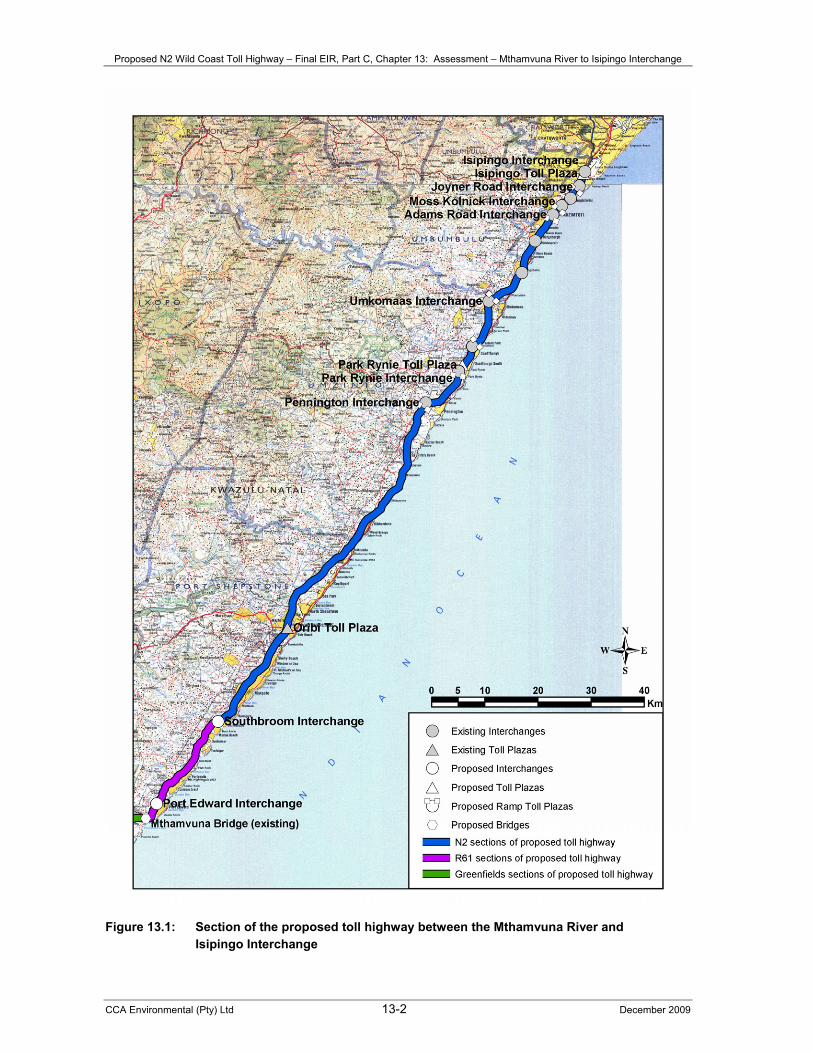
This chapter provides an assessment of the key potential biophysical, socio-economic and cultural/historical heritage impacts, as appropriate, that would result from the construction and operational phases of the proposed works, including physical toll plazas, along the existing R61 and N2 between the Mthamvuna River and the Isipingo Interchange - see Figures 13.1 and 13.2. 13.1 INTRODUCTION The proposed works along the existing R61 and N2 between the Mthamvuna River and the Isipingo Interchange are described in detail in Section 4.2.6, with accompanying illustrations being shown in Figures 4.25 to 4.32. All proposed construction activities would take place within the existing road reserve, with the exception of the Adams Road Interchange and the proposed mainline toll plazas at Park Rynie and Isipingo. In summary, the following works are proposed along this section of the proposed toll highway, where required: • Upgrading of at-grade intersections; • Construction of Port Edward and Southbroom Interchanges (refer to Figures 4.27 and 4.28); • Improvement of intersection layouts; • Consolidation of access points – illegal and dangerous accesses would be closed and feeder roads
constructed to provide access at new, safe and appropriate access [would be undertaken under a separate approval process];
• Safety improvements; • Minor rehabilitation and resurfacing; • Construction of seven sets of ramp toll plazas (on existing interchanges); • Construction of the proposed Park Rynie mainline toll plaza (in close proximity to the Park Rynie on-
and off-ramps - refer to Figure 4.29); • Widening of the Amanzimtoti Bridge; • Addition of a third lane and paved shoulder from Amanzimtoti River northward; • Reconstruction of the Adams Road Interchange to improve the operational safety of the
interchange; • Addition of a fourth lane between Dickens Road and Joyner Road Interchanges in each direction
(refer to Figure 4.31); and • Construction of the proposed Isipingo mainline toll plaza south of the Prospecton Road (Isipingo)
Interchange (refer to Figure 4.32). The existing N2 South Coast Toll Road, which comprises the Oribi mainline and ramp toll plazas, Izotsha ramp toll plazas and Umtentweni ramp toll plazas, would be incorporated into the proposed project. A description of the key characteristics of the biophysical, socio-economic and cultural/historical heritage environment along this section of the proposed toll highway is provided in Chapter 6, as appropriate. As mentioned in Section 6.2.6, no major road upgrades would be undertaken in the vicinity of the three protected areas located adjacent to the existing R61 in this section of the proposed toll highway during the Initial Construction Period.
Proposed N2 Wild Coast Toll Highway – Final EIR, Part C, Chapter 13: Assessment – Mthamvuna River to Isipingo Interchange
CCA Environmental (Pty) Ltd 13-2 December 2009
Figure 13.1: Section of the proposed toll highway between the Mthamvuna River and Isipingo Interchange
Proposed N2 Wild Coast Toll Highway – Final EIR, Part C, Chapter 13: Assessment – Mthamvuna River to Isipingo Interchange
CCA Environmental (Pty) Ltd 13-3 December 2009
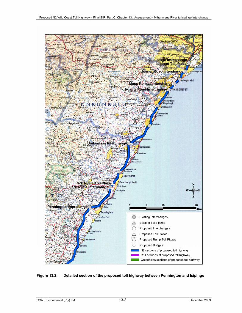
Figure 13.2: Detailed section of the proposed toll highway between Pennington and Isipingo

Proposed N2 Wild Coast Toll Highway – Final EIR, Part C, Chapter 13: Assessment – Mthamvuna River to Isipingo Interchange
CCA Environmental (Pty) Ltd 13-4 December 2009
The assessment of potential direct, indirect and cumulative impacts associated with the construction and operational phases of the proposed project are based on the findings of the relevant specialist studies undertaken during the EIA process. The respective specialist reports provide detailed descriptions of the study approach followed, the identified risk sources and potential impacts – Volumes 2 to 4, Appendices 1 to 13. 13.2 ASSESSMENT OF POTENTIAL IMPACTS It is anticipated that the proposed works along this section of the proposed toll highway would result in key potential impacts relating to the following aspects: vegetation and flora; fauna; aquatic ecosystems; social; noise; air quality; and visual. These are addressed separately below. 13.2.1 VEGETATION AND FLORA The proposed widening of the existing road and widening of the bridge at the Amanzimtoti River would result in key potential impacts on vegetation and flora in terms of the following aspects: loss of habitat, biodiversity and species of special concern; increased run-off and drainage, soil erosion, silt loads and sedimentation; and invasion by weeds and invasive alien plants. A summary of the assessment of the key potential impacts on vegetation and flora is provided in Table 13.1. Loss and/or fragmentation of habitat, loss of biodiversity and/or loss of species of special concern The proposed widening of the existing road to accommodate additional lanes may result in the loss of some habitat, with associated biodiversity and species of special concern. Such remaining habitat, which includes habitat associated with KwaZulu-Natal Coastal Belt vegetation (Endangered), is, however, scattered and consists of small remaining patches. It is considered unlikely that the proposed widening of the existing road would affect remaining patches of coastal thicket, but if they are affected the impact would be significant due to the high conservation status of the vegetation type. The potential permanent, localised loss of habitat is assessed to be of medium intensity and significance. The proposed widening of the bridge at the Amanzimtoti may affect riparian and floodplain vegetation alongside the existing bridge site which is already moderately disturbed. The potential localised loss and fragmentation of habitat is assessed to be of medium intensity and significance. Minimisation and restriction of site clearing to the area required for construction purposes only, limiting disturbance to adjacent undisturbed natural vegetation and identification of any Species of Special Concern by a botanical expert where indigenous thicket vegetation is encountered and revegetation of remaining disturbed areas with site indigenous species and minimisation of impacts on riparian and floodplain areas would result in probable residual impacts of LOW significance. Increased run-off and drainage, soil erosion, silt loads and sedimentation The increased pavement area associated with the proposed widening of the road and bridge at the Amanzimtoti River would probably result in increased run-off and drainage, soil erosion, silt loads and sedimentation. The potential localised loss or disturbance to vegetation and flora would probably be of medium intensity over the long term and is thus considered to be of medium significance. Minimisation and restriction of site clearing to areas required for construction purposes only, implementation of erosion and sediment control measures, appropriate location of site offices and ongoing monitoring and maintenance of revegetation works would reduce the significance of the potential impact to LOW.
Proposed N2 Wild Coast Toll Highway – Final EIR, Part C, Chapter 13: Assessment – Mthamvuna River to Isipingo Interchange
CCA Environmental (Pty) Ltd 13-5 December 2009
Invasion by weeds and invasive alien plants Invasion by weeds and invasive alien plants would be facilitated by disturbance resulting from construction-related activities and would likely be of greater importance during the operational phase. Potential localised impacts on the composition and function of the natural vegetation and flora would probably occur at a medium intensity over the long term. These potential impacts are thus deemed to be of medium significance. It is considered that implementation of an effective weed control programme would reduce the potential impact to LOW significance. Table 13.1: Summary assessment of key potential impacts on vegetation and flora – Mthamvuna
River to Isipingo Interchange
ISSUE / IMPACT EXTENT DURATION INTENSITY PROBABILITY SIGNIFICANCE CONFIDENCE Impacts associated with loss of habitat, biodiversity and species of special concern Without mitigation Local Permanent Medium Probable Medium Medium
With mitigation Local Permanent Low Probable LOW Medium Impacts associated with increased runoff and drainage, soil erosion, silt loads and sedimentation Without mitigation Local Long term Medium Probable Medium Medium
With mitigation Local Long term Low Probable LOW Medium Impacts associated with invasion by weeds and invasive alien plants Without mitigation Local Long term Medium Probable Medium High
With mitigation Local Long term Low Probable LOW High 13.2.2 FAUNA The anticipated increased road traffic associated with the operational phase of the proposed toll highway would result in key potential impacts on fauna in terms of the following aspects: invasion of alien faunal species; increased fire risk; chemical pollution; and noise and light pollution. A summary of the assessment of the key potential faunal impacts is provided in Table 13.2. Invasion of alien faunal species The probable passive translocation of alien faunal species associated with the anticipated increased road traffic along this section of the proposed toll highway is assessed to be of medium intensity over the long term and is thus deemed to be of medium significance. Active culling programmes of problem animals would reduce the significance of the probable residual impact to LOW. Increased fire risk Fire, particularly in grasslands, is a natural phenomenon. However, it is probable that the risk of accidental fires would increase as a result of improved access to this section of the proposed toll highway. The associated permanent long-term loss of fauna is assessed to be of medium intensity and significance. Ensuring vegetation in the road reserve is kept low by way of regular maintenance and that rest stops and associated structures are not situated adjacent to sensitive habitats would reduce the potential impacts associated with increased fire risk to LOW significance. Chemical pollution Probable negative effects on population sizes and developmental abnormalities of amphibian populations due to polluted surface run-off are assessed to be of medium intensity over the long term. The significance of the potential impacts on fauna is thus considered as medium. Restricting and controlling the use of herbicides in the road reserve would reduce the significance of the potential impacts associated with chemical pollution to LOW.
Proposed N2 Wild Coast Toll Highway – Final EIR, Part C, Chapter 13: Assessment – Mthamvuna River to Isipingo Interchange
CCA Environmental (Pty) Ltd 13-6 December 2009
Noise and light pollution Probable long-term disturbance to breeding faunal populations as a result of increased noise and light pollution from increased traffic volumes and lighting at mainline toll plazas and interchanges is assessed to be of MEDIUM intensity and significance. It is considered unlikely that disturbance to breeding faunal populations associated with noise and light pollution could be reduced. Table 13.2: Summary assessment of key potential impacts on fauna – Mthamvuna River to
Isipingo Interchange ISSUE / IMPACT EXTENT DURATION INTENSITY PROBABILITY SIGNIFICANCE CONFIDENCE Invasion of alien faunal species Without mitigation Local Long term Medium Probable Medium Medium
With mitigation Local Long term Low Probable LOW Medium Impacts associated with increased fire risk Without mitigation Local Long term Medium Probable Medium Medium
With mitigation Local Long term Low Probable LOW Medium Impacts associated with chemical pollution Without mitigation Local Long term Medium Probable Medium Medium
With mitigation Local Long term Low Probable LOW Medium Impacts associated with noise and light pollution Without mitigation Local Long term Medium Probable Medium Medium
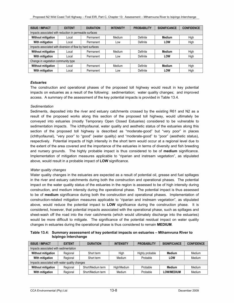
With mitigation Local Long term Medium Probable MEDIUM Medium 13.2.3 AQUATIC ECOSYSTEMS Riparian and instream vegetation Key potential impacts on riparian and instream vegetation are anticipated during the construction and operational phases of the proposed toll highway. These would be associated with the following: destruction of riparian vegetation and loss of sensitive habitats; increased surface run-off; surface and groundwater pollution; reduction in permeable surfaces ; diversion of flow by hard surfaces; and change in vegetation community type. A summary of the assessment of the key potential impacts is provided in Table 13.3. Destruction of riparian vegetation and loss of sensitive habitats The proposed works along this section of the proposed toll highway would result in destruction of riparian vegetation and loss of sensitive habitat. The expected permanent impact is assessed to be of medium intensity at a local level and is assigned a high significance rating due to the nature of the riparian vegetation and the important role it plays within the riverine ecosystems. Clearing of vegetation during the drier winter months, limiting clearing to areas immediately needed for construction, undertaking vegetation stripping in parallel with road construction and avoiding large stands of Palmiet would reduce the significance of the potential impact to LOW. Increased surface run-off Site clearing activities and the increased pavement area associated with the proposed upgrading, rehabilitation and widening of the road, where required, would result in increased surface run-off and increased risk of erosion. Vegetation attenuates surface water flow which, consequently, encourages permeation of the soils and contributes to maintaining water table levels. The anticipated permanent impact on riparian and instream vegetation during the construction and operational phases is assessed to be of medium intensity and significance. Potential residual impacts of LOW significance are expected with implementation of a surface stormwater drainage system and the use of swales during construction (which should then be grassed for the operational phase).

Proposed N2 Wild Coast Toll Highway – Final EIR, Part C, Chapter 13: Assessment – Mthamvuna River to Isipingo Interchange
CCA Environmental (Pty) Ltd 13-7 December 2009
Surface water and groundwater pollution Construction activities would probably result in sediment loads entering the adjacent freshwater ecosystems, leading to increased turbidities and sedimentation risks in downstream areas. Diesel, oils and other chemical substances conveyed along the road during the operational phase would pose a threat to the continued functioning of the instream and adjacent areas, if by chance these are dispersed via surface run-off, or permeate into the groundwater. Changes to water quality (surface and groundwater) affect the functioning of plants and other instream biota. The potential impact on riparian and instream vegetation along this section of the proposed toll highway is assessed to be permanent and of medium intensity at a local level. The significance of the potential impact is thus rated as medium. Formulation and implementation of erosion and sediment control measures, proper storage of construction materials (including fuels and oils), emergency plans, construction camp management procedures and appropriate location (i.e. well removed from aquatic systems) of stockpiles, site offices, etc. would reduce the potential impact to LOW significance. Reduction in permeable surfaces The hard surfaces associated with the proposed upgrading, rehabilitation and widening of this section of the proposed toll highway would reduce the amount of permeable surfaces for water to penetrate the soils and maintain the local groundwater systems. The potential indirect impact on riparian and instream vegetation due to changes in soil moisture status is assessed to be permanent and of medium intensity at a local level. This potential impact is thus rated of medium significance. Revegetation of all remaining disturbed areas with appropriate plant species would reduce the potential impact to LOW significance. Diversion of flow by hard surfaces The increased area of hard surfaces would probably divert flow away from water bodies, as well as increase flow velocities of run-off and increase the risk of pollution if the stormwater contains any spilled oils, fuels or coolants from passing traffic. The potential permanent impact on riparian and instream vegetation is assessed to be of medium intensity and significance. Residual potential impacts of LOW significance would result by way of the design and use of stormwater retention swales and oil traps to prevent contamination of downstream areas. Change in vegetation community type Disturbance of the natural vegetation caused by the construction activities would lead to the potential introduction of exotic plant species. The potential localised change to the indigenous riparian and instream vegetation is assessed to be of permanent duration and medium intensity and significance. Implementation of an appropriate rehabilitation and weed control programme would result in a potential residual impact of LOW significance. Table 13.3: Summary assessment of key potential impacts on riparian and instream vegetation –
Mthamvuna River to Isipingo Interchange ISSUE / IMPACT EXTENT DURATION INTENSITY PROBABILITY SIGNIFICANCE CONFIDENCE Destruction of riparian vegetation and loss of sensitive habitats Without mitigation Local Permanent Medium Definite Medium High
With mitigation Local Permanent Low Definite LOW High Impacts associated with increased surface run-off Without mitigation Local Permanent Medium Definite Medium High
With mitigation Local Permanent Low Definite LOW High Impacts associated with surface and groundwater pollution Without mitigation Local Permanent Medium Definite Medium High
With mitigation Local Permanent Low Definite LOW High
Proposed N2 Wild Coast Toll Highway – Final EIR, Part C, Chapter 13: Assessment – Mthamvuna River to Isipingo Interchange
CCA Environmental (Pty) Ltd 13-8 December 2009
ISSUE / IMPACT EXTENT DURATION INTENSITY PROBABILITY SIGNIFICANCE CONFIDENCE Impacts associated with reduction in permeable surfaces Without mitigation Local Permanent Medium Definite Medium High
With mitigation Local Permanent Low Definite LOW High Impacts associated with diversion of flow by hard surfaces Without mitigation Local Permanent Medium Definite Medium High
With mitigation Local Permanent Low Definite LOW High Change in vegetation community type Without mitigation Local Permanent Medium Definite Medium High
With mitigation Local Permanent Low Definite LOW High
Estuaries The construction and operational phases of the proposed toll highway would result in key potential impacts on estuaries as a result of the following: sedimentation; water quality changes; and improved access. A summary of the assessment of the key potential impacts is provided in Table 13.4. Sedimentation Sediments, deposited into the river and estuary catchments crossed by the existing R61 and N2 as a result of the proposed works along this section of the proposed toll highway, would ultimately be conveyed into estuaries (mostly Temporary Open Closed Estuaries) considered to be vulnerable to sedimentation impacts. The ichthyofaunal, water quality and aesthetic status of the estuaries along this section of the proposed toll highway is described as “moderate-good” but “very poor” in places (ichthyofaunal), “very poor” to “good” (water quality) and “moderate-good” to “poor” (aesthetic status), respectively. Potential impacts of high intensity in the short term would occur at a regional level due to the extent of the area covered and the importance of the estuaries in terms of diversity and fish breeding and nursery grounds. The highly probable impact is thus considered to be of medium significance. Implementation of mitigation measures applicable to “riparian and instream vegetation”, as stipulated above, would result in a probable impact of LOW significance. Water quality changes Water quality changes in the estuaries are expected as a result of potential oil, grease and fuel spillages in the river and estuary catchments during both the construction and operational phases. The potential impact on the water quality status of the estuaries in the region is assessed to be of high intensity during construction, and medium intensity during the operational phase. The potential impact is thus assessed to be of medium significance during both the construction and operational phases. Implementation of construction-related mitigation measures applicable to “riparian and instream vegetation”, as stipulated above, would reduce the potential impact to LOW significance during the construction phase. It is considered, however, that potential impacts associated with the operational phase, such as spillages and sheet-wash off the road into the river catchments (which would ultimately discharge into the estuaries) would be more difficult to mitigate. The significance of the potential residual impact on water quality changes in estuaries during the operational phase is thus considered to remain MEDIUM.
Table 13.4: Summary assessment of key potential impacts on estuaries – Mthamvuna River to Isipingo Interchange
ISSUE / IMPACT EXTENT DURATION INTENSITY PROBABILITY SIGNIFICANCE CONFIDENCE Impacts associated with sedimentation Without mitigation Regional Short term High Highly probable Medium Medium
With mitigation Regional Short term Medium Probable LOW Medium Impacts associated with water quality changes Without mitigation Regional Short/Medium term High/Medium Probable Medium Medium
With mitigation Regional Short/Medium term Medium Probable LOW/MEDIUM Medium
Proposed N2 Wild Coast Toll Highway – Final EIR, Part C, Chapter 13: Assessment – Mthamvuna River to Isipingo Interchange
CCA Environmental (Pty) Ltd 13-9 December 2009
13.2.4 SOCIAL The proposed toll highway would result in key potential social impacts relating to the following: increased employment opportunities; increased safety hazards for pedestrians and traffic; increased HIV/AIDS and STD risks; increased crime; construction-related traffic delays; increased taxi-related tension and violence; and resettlement of affected households. A summary of the assessment of the key potential impacts is provided in Table 13.5. Increased employment opportunities Unemployment figures for wards along this section of the proposed toll highway are often below 20%, which indicate that unemployment levels along this section of the proposed toll highway are generally markedly lower than for most of the Eastern Cape sections. The proposed project would increase the potential for job creation in the section between the Mthamvuna River and the Isipingo Interchange. Both direct and indirect jobs of a temporary nature are likely to occur during the construction phase while the operational phase is likely to generate more permanent and sustainable employment opportunities. The significance of the anticipated positive impact associated with increased employment opportunities is assessed to be positive medium (during construction) and positive low-medium (during the operational phase). Optimisation measures such as establishment of a “labour and employment desk”, use of labour-intensive methods where possible, use of local labour as far as possible and remuneration beyond the minimum wage rate would increase the significance of the potential positive impact to POSITIVE HIGH and POSITIVE MEDIUM significance during the construction and operational phases, respectively. Increased safety hazards for pedestrians and traffic Construction sites and associated activities, and an increase in traffic volumes during the operational phase, would lead to increased safety hazards for pedestrians and traffic. The potential impact is assessed to be of medium significance during the construction and operational phases. Regular inspection and maintenance of fencing, erection of appropriate warning signs and implementation of community risk awareness programmes would reduce the intensity and significance of the potential impact to LOW. Increased risk of HIV/AIDS and STDs The anticipated influx of construction workers during construction, and the anticipated increased long-distance truck traffic on the proposed toll highway, would probably result in an increased risk of HIV/AIDS and STDs. The potential impact is assessed to be of medium significance during the construction and operational phases, respectively. Mitigation measures aimed at reducing the spread of HIV/AIDS and STDs, such as the design and implementation of appropriate HIV/AIDS and STD awareness and prevention campaigns, maximisation of job opportunities to local people who do not need to be housed in construction accommodation, and availability of an adequate supply of free condoms for workers would reduce the risk of the spread of HIV/AIDS and STDs to LOW-MEDIUM significance during the construction and operational phases. Increased crime Potential increase in criminal activity could occur in this section of the proposed toll highway due to an influx of workers during construction and the increased regional accessibility of the area during the operational phase. The probable impact is assessed of medium significance during the construction and operational phases. Liaison with the local police to monitor changes during construction and operation, provision of additional security if required and assistance with establishment of Community Policing Forums where they do not exist would reduce the probability and significance of the potential impact to LOW.
Proposed N2 Wild Coast Toll Highway – Final EIR, Part C, Chapter 13: Assessment – Mthamvuna River to Isipingo Interchange
CCA Environmental (Pty) Ltd 13-10 December 2009
Construction-related traffic delays Traffic delays and accommodation of traffic during construction would result in potential increased incidences of road rage and time delays for road users and would be detrimental to the efficient running of business. According to many stakeholders, potential construction-related delays could possible also make the South Coast less attractive to tourists. The probable impact is assessed to be of MEDIUM significance without and with mitigation since it is deemed unlikely that the impact can be effectively mitigated. However, it is recommended that construction activities be properly scheduled to minimise delays and that an effective public communication strategy be formulated and implemented to inform road users of construction activities timeously. Increased taxi-related tension and violence It is anticipated that the proposed toll highway would result in potential increased internal taxi-related tension and violence associated with the profitability of certain routes. This potential impact is considered to be of medium intensity and significance over the long term. The intensity, and hence significance, of this potential impact would be reduced to LOW through consultation with the relevant taxi industries, in particular regarding the implementation of tolling and potential discounts. Table 13.5: Summary assessment of key potential social impacts – Mthamvuna River to Isipingo
Interchange ISSUE / IMPACT EXTENT DURATION INTENSITY PROBABILITY SIGNIFICANCE CONFIDENCE Impacts associated with increased employment opportunities Without mitigation Local-Regional Short/Long term Medium/High Definite Low-medium+/Medium+ High
With mitigation Local-Regional Short/Long term High Definite MEDIUM+/HIGH+ High Increased safety hazards for pedestrians and traffic Without mitigation Local-Regional Short/Permanent High Definite Medium Medium
With mitigation Local-Regional Short/Permanent Medium Definite LOW Medium Impacts associated with increased risk of HIV/AIDS and STDs Without mitigation Local Permanent Medium Probable Medium Medium
With mitigation Local Permanent Low-Medium Probable LOW-MEDIUM Medium Increased crime Without mitigation Local Permanent Medium Probable Medium Medium
With mitigation Local Permanent Low Probable LOW Medium Impacts associated with construction-related traffic delays Without mitigation Local Short/Long term Medium/High Probable Medium Medium
With mitigation Local Short/Long term Medium/High Probable MEDIUM Medium Increased taxi-related tension Without mitigation Local Long term Medium Probable Medium Medium
With mitigation Local Long term Low Probable LOW Medium 13.2.5 NOISE It is anticipated that the proposed Pennington ramp toll plazas, Park Rynie mainline toll plaza, Adams Road ramp toll plazas and additional lanes in this section of the proposed toll highway would result in key potential noise impacts. A summary of the assessment of the key potential impacts is provided in Table 13.6. Pennington ramp toll plazas Settlements are located within 40 m to the west of the southern off-ramp. It is considered that the elevated ramp and ramp toll plaza would screen the residences from traffic noise on the highway thereby rendering noise on the ramp more noticeable. The intensity and significance of the highly probable noise
Proposed N2 Wild Coast Toll Highway – Final EIR, Part C, Chapter 13: Assessment – Mthamvuna River to Isipingo Interchange
CCA Environmental (Pty) Ltd 13-11 December 2009
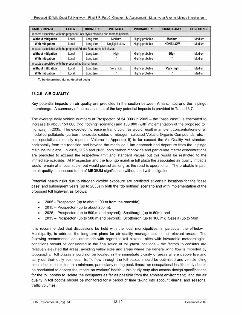
impact is rated to be high. Noise mitigation procedures would be required in the form of a 2 m high noise barrier extending 20 m on either side of the toll booth. It is expected that the residual intensity and significance of the noise impact would be reduced to LOW-MEDIUM. Park Rynie mainline toll plaza Suburban residential land would be located approximately 350 m east of the location for the proposed Park Rynie mainline toll plaza. It is predicted that the intensity of the noise impact associated with the operation of the toll plaza would range between low and medium, thus the potential impact is deemed of medium significance. Locating the toll plaza at least 630 m from the nearest suburban residential land would reduce the intensity and significance of the noise impact to NEGLIGIBLE. Alternatively, a noise barrier (of at least 3 m height and extending 100 m beyond each side of the toll booths) would reduce the intensity and significance of the potential noise impact to LOW. Adams Road ramp toll plazas Commercial land would be located to the east of the reconstructed Adams Road Interchange and ramp toll plazas for which no noise impact is anticipated. However, noise sensitive land is situated in close proximity of both the existing ramps. The increased elevation of the proposed new off-ramp and commencement of the on-ramp would result in these being more exposed to existing residences. The potential intensity and significance of the noise impact on this land is assessed to be high. The potential noise impact of toll plazas on the new ramps, and relevant noise mitigation measures, would need to be determined and incorporated at the detail design stage, as appropriate. Additional lanes between the Amanzimtoti River Bridge and Isipingo Interchange Road traffic on the existing N2 between Amanzimtoti and the Isipingo Interchange causes the current noise rating level on adjacent land to significantly exceed the 65 dBA maximum limit stipulated by the Noise Control Regulations for all noise sensitive land excluding land zoned for industrial use. The addition of a third lane (and fourth lane between Dickens Road and Joyner Road Interchanges in each direction) is expected to result in a further increase in the noise rating level. The N2 passes through residential suburbs along this section of the proposed toll highway with residential properties extending up to the road reserve. At least one school (i.e. Umbogintwini Primary) also bounds the road reserve. In terms of the Noise Control Regulations, noise mitigation measures along this section would need to be implemented to reduce the noise rating level to 65 dBA on all land zoned for residential, educational, hospital and office use. This implies the reduction of existing noise levels that are significantly higher than 65 dBA. Due to the variation in topography, the distance to nearest noise sensitive land, the available space and the ground conditions for the erection of noise barriers, the mitigation measures along this section of the proposed toll highway would need to be determined and incorporated at the detailed design stage, with due regard to cost implications of each alternative and/or combined noise mitigation procedures. It should be noted that compliance with the legal requirements of the Noise Control Regulations (ensuring that the noise rating level does not exceed 65 dBA) might still result in a noise impact that is unacceptable in terms of SANS 10103 (refer to the noise specialist report, Volume 3, Appendix 8). Table 13.6: Summary assessment of key potential noise impacts – Mthamvuna River to Isipingo
Interchange ISSUE / IMPACT EXTENT DURATION INTENSITY PROBABILITY SIGNIFICANCE CONFIDENCE Impacts associated with the proposed Pennington ramp toll plazas Without mitigation Local Long term High Highly probable High Medium
With mitigation Local Long term Low-Medium Highly probable LOW-MEDIUM Medium
Proposed N2 Wild Coast Toll Highway – Final EIR, Part C, Chapter 13: Assessment – Mthamvuna River to Isipingo Interchange
CCA Environmental (Pty) Ltd 13-12 December 2009
ISSUE / IMPACT EXTENT DURATION INTENSITY PROBABILITY SIGNIFICANCE CONFIDENCE Impacts associated with the proposed Park Rynie mainline and ramp toll plazas Without mitigation Local Long term Medium Highly probable Medium Medium
With mitigation Local Long term Negligible/Low Highly probable NONE/LOW Medium Impacts associated with the proposed Adams Road ramp toll plazas Without mitigation Local Long term High Highly probable High Medium
With mitigation Local Long term * Highly probable * Medium Impacts associated with the proposed additional lanes Without mitigation Local Long term Very high Highly probable Very high Medium
With mitigation Local Long term * Highly probable * Medium
* To be determined during detailed design 13.2.6 AIR QUALITY Key potential impacts on air quality are predicted in the section between Amanzimtoti and the Isipingo Interchange. A summary of the assessment of the key potential impacts is provided in Table 13.7. The average daily vehicle numbers at Prospecton of 54 000 (in 2005 – the “base case”) is estimated to increase to about 150 000 (“do nothing” scenario) and 133 000 (with implementation of the proposed toll highway) in 2035. The expected increase in traffic volumes would result in ambient concentrations of all modelled pollutants (carbon monoxide, oxides of nitrogen, selected Volatile Organic Compounds, etc. – see specialist air quality report in Volume 4, Appendix 9) to far exceed the Air Quality Act standard horizontally from the roadside and beyond the modelled 1 km approach and departure from the Isipingo mainline toll plaza. In 2015, 2025 and 2035, both carbon monoxide and particulate matter concentrations are predicted to exceed the respective limit and standard values but this would be restricted to the immediate roadside. At Prospecton and the Isipingo mainline toll plaza the associated air quality impacts would remain at a local scale, but would persist as long as the road is operational. The probable impact on air quality is assessed to be of MEDIUM significance without and with mitigation. Potential health risks due to nitrogen dioxide exposure are predicted at certain locations for the “base case” and subsequent years (up to 2035) in both the “do nothing” scenario and with implementation of the proposed toll highway, as follows:
• 2005 - Prospecton (up to about 100 m from the roadside); • 2015 – Prospecton (up to about 250 m); • 2025 – Prospecton (up to 500 m and beyond); Scottburgh (up to 50m); and • 2035 – Prospecton (up to 500 m and beyond); Scottburgh (up to 100 m); Sezela (up to 50m).
It is recommended that discussions be held with the local municipalities, in particular the eThekwini Municipality, to address the long-term plans for air quality management in the relevant areas. The following recommendations are made with regard to toll plazas: sites with favourable meteorological conditions should be considered in the finalisation of toll plaza locations – the factors to consider are relatively elevated flat areas, avoiding valley sites and areas where the general wind flow is impeded by topography; toll plazas should not be located in the immediate vicinity of areas where people live and carry out their daily business; traffic flow through the toll plazas should be optimised and vehicle idling times should be limited to a minimum, particularly during peak times; an occupational health study should be conducted to assess the impact on workers’ health – this study may also assess design specifications for the toll booths to isolate the occupants as far as possible from the ambient environment; and the air quality in toll booths should be monitored for a period of time taking into account diurnal and seasonal traffic volumes.
Proposed N2 Wild Coast Toll Highway – Final EIR, Part C, Chapter 13: Assessment – Mthamvuna River to Isipingo Interchange
CCA Environmental (Pty) Ltd 13-13 December 2009
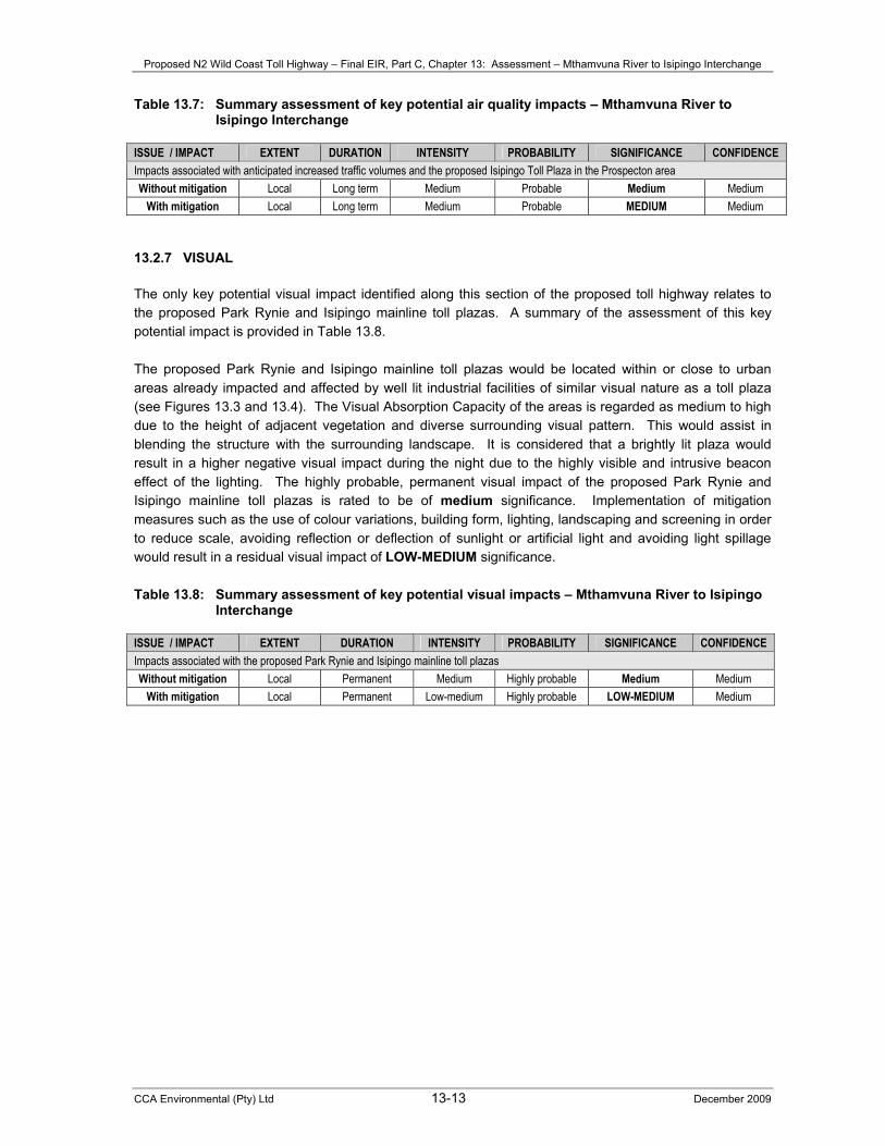
Table 13.7: Summary assessment of key potential air quality impacts – Mthamvuna River to Isipingo Interchange
ISSUE / IMPACT EXTENT DURATION INTENSITY PROBABILITY SIGNIFICANCE CONFIDENCE Impacts associated with anticipated increased traffic volumes and the proposed Isipingo Toll Plaza in the Prospecton area Without mitigation Local Long term Medium Probable Medium Medium
With mitigation Local Long term Medium Probable MEDIUM Medium 13.2.7 VISUAL The only key potential visual impact identified along this section of the proposed toll highway relates to the proposed Park Rynie and Isipingo mainline toll plazas. A summary of the assessment of this key potential impact is provided in Table 13.8. The proposed Park Rynie and Isipingo mainline toll plazas would be located within or close to urban areas already impacted and affected by well lit industrial facilities of similar visual nature as a toll plaza (see Figures 13.3 and 13.4). The Visual Absorption Capacity of the areas is regarded as medium to high due to the height of adjacent vegetation and diverse surrounding visual pattern. This would assist in blending the structure with the surrounding landscape. It is considered that a brightly lit plaza would result in a higher negative visual impact during the night due to the highly visible and intrusive beacon effect of the lighting. The highly probable, permanent visual impact of the proposed Park Rynie and Isipingo mainline toll plazas is rated to be of medium significance. Implementation of mitigation measures such as the use of colour variations, building form, lighting, landscaping and screening in order to reduce scale, avoiding reflection or deflection of sunlight or artificial light and avoiding light spillage would result in a residual visual impact of LOW-MEDIUM significance. Table 13.8: Summary assessment of key potential visual impacts – Mthamvuna River to Isipingo
Interchange ISSUE / IMPACT EXTENT DURATION INTENSITY PROBABILITY SIGNIFICANCE CONFIDENCE Impacts associated with the proposed Park Rynie and Isipingo mainline toll plazas Without mitigation Local Permanent Medium Highly probable Medium Medium
With mitigation Local Permanent Low-medium Highly probable LOW-MEDIUM Medium

Proposed N2 Wild Coast Toll Highway – Final EIR, Part C, Chapter 13: Assessment – Mthamvuna River to Isipingo Interchange
CCA Environmental (Pty) Ltd 13-14 December 2009
Figure 13.3: Park Rynie mainline toll plaza viewshed analysis

Proposed N2 Wild Coast Toll Highway – Final EIR, Part C, Chapter 13: Assessment – Mthamvuna River to Isipingo Interchange
CCA Environmental (Pty) Ltd 13-15 December 2009
Figure 13.4: Isipingo mainline toll plaza viewshed analysis