chapter 2: bad axe - la crosse river basin land resources
TRANSCRIPT

State of the Bad Axe-La Crosse Basin Report 2002
1
CHAPTER 2: BAD AXE - LA CROSSE RIVER BASIN LAND RESOURCES.................................. 10
FORESTS .................................................................................................................................................... 10GRASSLANDS............................................................................................................................................. 11WETLANDS ................................................................................................................................................ 14
La Crosse River Marsh ......................................................................................................................... 15AGRICULTURAL LANDS ............................................................................................................................. 16PUBLIC LANDS........................................................................................................................................... 17
Public Lands in Crawford County within the Bad Axe - La Crosse River Basin .................................. 18Public Lands in La Crosse County within the Bad Axe - La Crosse River Basin ................................. 19Public Lands in Monroe County within the Bad Axe - La Crosse River Basin ..................................... 21Public Lands in Vernon County within the Bad Axe - La Crosse River Basin...................................... 22
REFERENCES – CHAPTER 2 ........................................................................................................................ 24
Figure 8. Cottonwood tree in the La Crosse River Marsh............................................................................ 10Figure 9. Rush Creek State Natural Area bluffs managed as prairie on STH 35. ......................................... 14Figure 10. La Crosse River Marsh ................................................................................................................ 16Figure 11. Birds eye view of contour strips in La Crosse County. .............................................................. 17Figure12: Hixon Forest Nature Preserve and Center .................................................................................... 20Figure 13 Coon Creek Fishery Area: (Right)............................................................................................... 22
State of the Bad Axe-La Crosse Basin Report 2002
10
Chapter 2: Bad Axe - La Crosse River Basin Land Resources
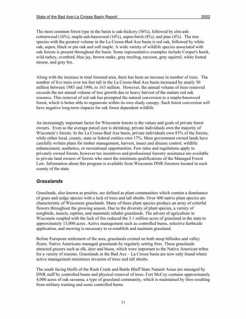
The Bad Axe – La Crosse River basin covers nearly 1,000 square miles within the driftless, orunglaciated, portion of the state. Typical terrain consists of ridges with steep slopes and narrowstream valleys, characteristic of the coulee region. An elevation difference of 700 feet from valleyfloor to ridgetop is not uncommon. Soils are silt loam (loess) and sandy loam over sandstone anddolomite. Aside from agricultural crops, vegetation in the basin consists of oak forest, degradedoak savanna, grassland, dry prairie, and bottomland hardwoods. Exposed sandstone and dolomitecliffs are common throughout the basin. The major land use is agriculture, including dairy andbeef farms, located on ridge tops as well as stream valleys. Highly erodable lands, common in thedriftless area, are either in hardwoods or in set-aside programs such as the Conservation ReserveProgram (CRP). Wooded slopes are often managed for oak/hardwood production, however due tohigh tax assessments of non-agricultural land, more wooded slopes are now being grazed.
Forests
Of Wisconsin’s 35 million acres of land, about 16 million acres, or 46%, is forested. The forestedlands are important in many ways. Forests protect and enhance air and water quality, providerecreational opportunities, wildlife habitat, biodiversity, wood products and a variety of othervalues that improve our quality of life. “Trees are important to Wisconsin landscapes from thestandpoint of beauty as single specimens or in groups. In forest and farm woodlands, they arevital tools for the stabilization of soil and in slowing water runoff. Forests are our largest publichunting and fishing grounds and produce wildlife and recreational benefits as well as timbercrops.” stated Fred Wilson in 1928, who was one of the first eleven forest rangers hired by theState of Wisconsin in 1911.
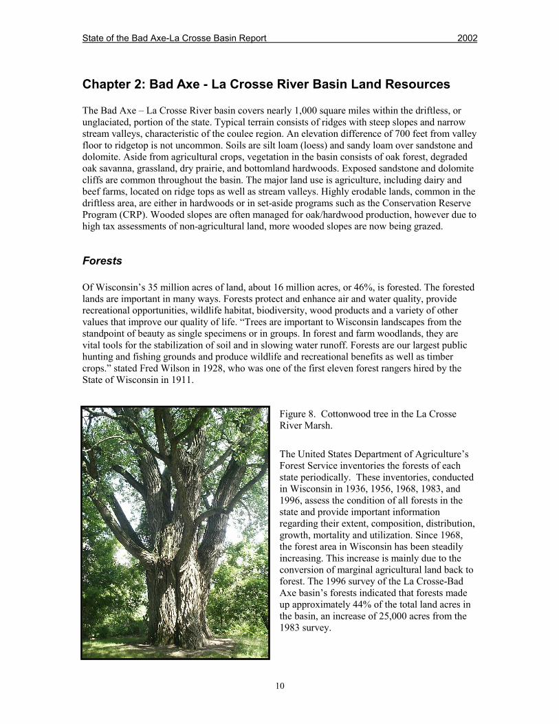
Figure 8. Cottonwood tree in the La CrosseRiver Marsh.
The United States Department of Agriculture’sForest Service inventories the forests of eachstate periodically. These inventories, conductedin Wisconsin in 1936, 1956, 1968, 1983, and1996, assess the condition of all forests in thestate and provide important informationregarding their extent, composition, distribution,growth, mortality and utilization. Since 1968,the forest area in Wisconsin has been steadilyincreasing. This increase is mainly due to theconversion of marginal agricultural land back toforest. The 1996 survey of the La Crosse-BadAxe basin’s forests indicated that forests madeup approximately 44% of the total land acres inthe basin, an increase of 25,000 acres from the1983 survey.
State of the Bad Axe-La Crosse Basin Report 2002
11
The most common forest type in the basin is oak-hickory (56%), followed by elm-ash-cottonwood (16%), maple-ash-basswood (16%), aspen-birch (8%), and pine (4%). The treespecies with the greatest volume in the La Crosse-Bad Axe basin is red oak, followed by whiteoak, aspen, black or pin oak and soft maple. A wide variety of wildlife species associated withoak forests is present throughout the basin. Some representative examples include Cooper's hawk,wild turkey, ovenbird, blue jay, brown snake, gray treefrog, raccoon, gray squirrel, white footedmouse, and gray fox.
Along with the increase in total forested area, there has been an increase in number of trees. Thenumber of live trees over ten feet tall in the La Crosse-Bad Axe basin increased by nearly 50million between 1983 and 1996, to 163 million. However, the annual volume of trees removedexceeds the net annual volume of tree growth due to heavy harvest of the mature red oakresource. This removal of red oak has prompted the natural conversion to a maple-basswoodforest, which is better able to regenerate within its own shady canopy. Such forest conversion willhave negative long-term impacts for oak forest dependent wildlife.
An increasingly important factor for Wisconsin forests is the values and goals of private forestowners. Even as the average parcel size is shrinking, private individuals own the majority ofWisconsin’s forests. In the La Crosse-Bad Axe basin, private individuals own 83% of the forests,while either local, county, state or federal entities own 17%. Most government owned lands havecarefully written plans for timber management, harvest, insect and disease control, wildlifeenhancement, aesthetics, or recreational opportunities. Few rules and regulations apply toprivately owned forests, however tax incentives and professional forestry assistance are availableto private land owners of forests who meet the minimum qualifications of the Managed ForestLaw. Information about this program is available from Wisconsin DNR foresters located in eachcounty of the state.
Grasslands
Grasslands, also known as prairies, are defined as plant communities which contain a dominanceof grass and sedge species with a lack of trees and tall shrubs. Over 400 native plant species arecharacteristic of Wisconsin grasslands. Many of these plant species produce an array of colorfulflowers throughout the growing season. Due to the diversity of plant species, a variety ofsongbirds, insects, reptiles, and mammals inhabit grasslands. The advent of agriculture inWisconsin coupled with the lack of fire reduced the 3.1 million acres of grassland in the state toapproximately 13,000 acres. Active management such as controlled burns, selective herbicideapplication, and mowing is necessary to re-establish and maintain grassland.
Before European settlement of the area, grasslands existed on both steep hillsides and valleyfloors. Native Americans managed grasslands by regularly setting fires. These grasslandsattracted grazers such as elk, deer and bison, which were important to the Native American tribesfor a variety of reasons. Grasslands in the Bad Axe – La Crosse basin are now only found whereactive management minimizes invasion of trees and tall shrubs.
The south facing bluffs of the Rush Creek and Battle Bluff State Natural Areas are managed byDNR staff by controlled burns and physical removal of trees. Fort McCoy contains approximately4,000 acres of oak savanna, a type of grassland community, which is maintained by fires resultingfrom military training and some controlled burns.

State of the Bad Axe-La Crosse Basin Report 2002
14
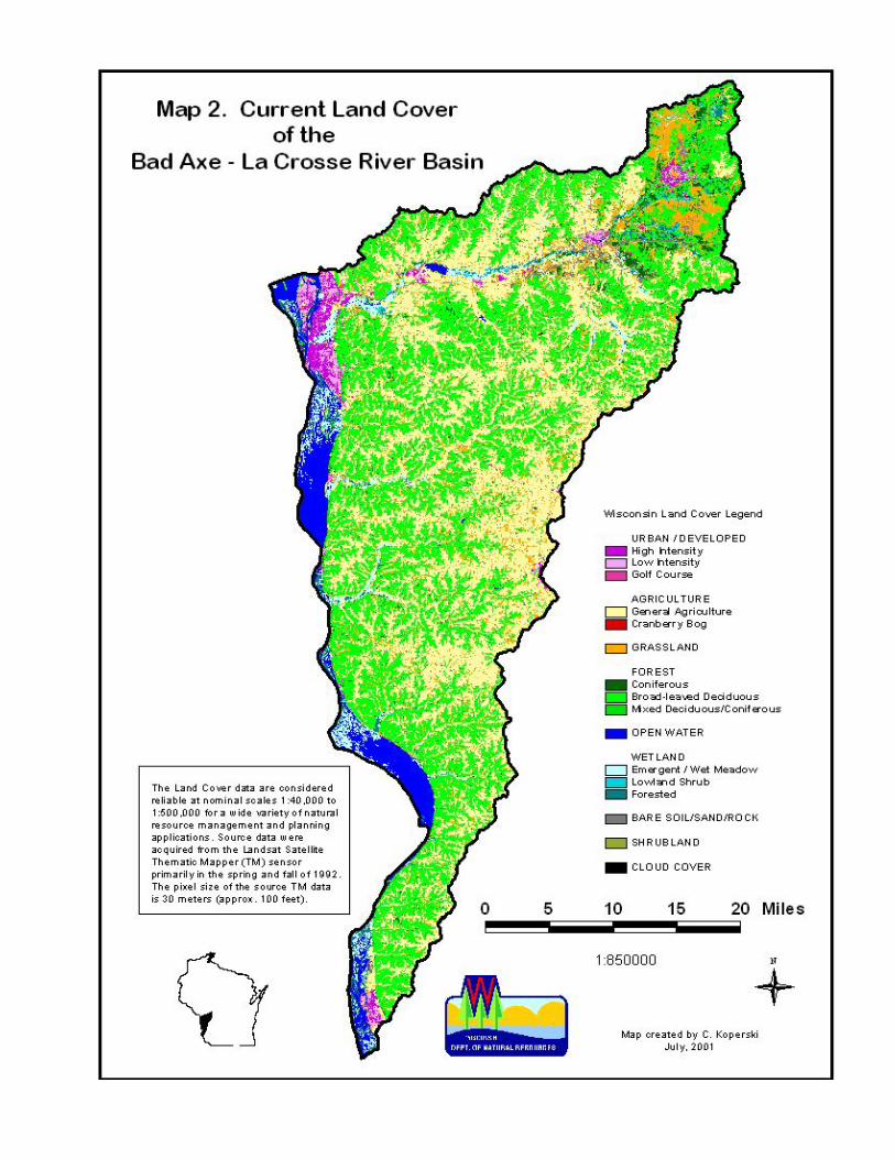
Figure 9. Rush CreekState Natural Area bluffsmanaged as prairie onSTH 35.
Grassland wildlifehabitat and species willcontinue to decline dueto agricultural use andurban development ofexisting grassland. TheU.S. Department ofAgriculture NaturalResource ConservationService (NRCS) offers aConservation ReserveProgram (CRP) and othersimilar programs which provide financial incentive for farmers to set aside highly erodable landto plant grassland species. Management of this grassland acreage may be between 10 and 15years. These set aside programs may temporarily offset some of the grassland loss.
Wetlands
Once considered wastelands and breeding grounds for mosquitos, wetlands are now recognized asproviding critical habitat for wildlife, water storage, groundwater recharge, and recreationalopportunities for wildlife watchers, hunters, and trappers. All wetlands have a commoncharacteristic – soils that are periodically saturated with or covered by water. Only 53%, or 5.3million acres, remain of the original 10 million wetland acres in the State of Wisconsin. Whilebetter understood and no longer destroyed as rapidly as a century ago, wetlands in Wisconsincontinue to be lost and degraded in quality. Wetlands continue to be filled for road constructionand other types of development, altered for cranberry production, and drained for agricultural use.Some are deteriorating as changing land use around them alters water flow and introducessediment. The fragmentation of wetlands by legal or illegal filling often results in changes to themovement of water and animals which usually reduces the productivity of the once intactwetland. Federal, state and local regulations and land acquisition programs are making progressin slowing further wetland loss. However, laws will never prevent all losses nor will financialresources ever be enough to acquire all wetlands that need protection.
Excluding the Mississippi River associated wetlands, the Bad Axe – La Crosse basin containsapproximately 11,400 acres of wetland, which is less than 2% of the entire basin. The steeptopography of the basin is not favorable for wetlands; however, the hills quickly convey rainwater and snow melt to the nearest stream channel where the steep gradient efficiently moves thewater downstream. Near the lower end of large streams in the basin the gradient significantlydecreases and the valley widens. These lower river valleys contain water that regularly saturatesthe adjacent soil, thus maintaining wetland characteristics. Large expanses of wetland in the basinare found along the lower portion of the La Crosse River, the Bad Axe River and Coon Creek.Smaller wetlands are commonly associated with many groundwater seeps and springs in thecoulee region. These smaller wetlands are very important since they help maintain the waterquality and quantity of nearby streams.
State of the Bad Axe-La Crosse Basin Report 2002
15
Programs in three levels of government-local, state, and federal-regulate activities in and nearwetlands. The complexity of several layers of regulations requires landowners to contact theirlocal zoning office, the Wisconsin DNR, and the U. S. Corps of Engineers to acquire thenecessary information and applications for wetland activities. Building Near Wetlands: The DryFacts (PUBL-WZ-WZ021 91) is a DNR publication that explains much of the process involvedwith building in or near wetlands.
Opportunities exist to protect and restore wetlands in the basin. The U.S. Department ofAgriculture Natural Resources Conservation Service offers the Wetlands Reserve Program(WRP). This voluntary program allows landowners to receive financial incentives to enhancewetlands in exchange for retiring marginal agricultural land. The sale or donation of conservationeasements to county, state, or federal agencies or non-profit conservancy groups also protectswetlands in the Bad Axe - La Crosse basin. The Mississippi Valley Conservancy, County Landand Water Conservation Departments, Wisconsin DNR, and the Natural Resources ConservationService, U.S. Fish and Wildlife Service, and Ducks Unlimited offer opportunities and expertise inprotecting wetlands.
La Crosse River Marsh
The La Crosse River flows through nearly 4,000 acres of adjacent wetland between LakeNeshonoc and the Mississippi River. Tamarack swamp, floodplain forest, seasonal and permanentwet areas with wetland plants are all common within this extensive wetland complex. Situated inthe Mississippi flyway, these wetlands are heavily used by waterfowl for breeding and as amigratory stopover site. These wetlands also provide habitat for numerous species of rare,wetland-dependent birds, reptiles and plants. The portion of the La Crosse River that flowsthrough the marsh contains 64 species of fish, which is 40% of the fish species that occurthroughout Wisconsin. Included among them are three state threatened species: speckled chub,blue sucker, and river redhorse, and two species of special concern: western sand darter andAmerican eel. During extended periods of high water, northern pike utilize the marsh as a nurseryfor their young. Four frog species and one toad species were documented during spring callingsurveys in 1998.
The portion of the La Crosse River marsh west of HWY 16 is bisected by roads, railroads, andtransmission lines. Myrick Park, located on the south side of the marsh in the City of La Crosse,contains an elevated trail that traverses the southern portion of the marsh. This trail serves aneducational purpose using interpretive plaques to educate the community about the biologicalimportance of the marsh.
Plans to fill and develop the marsh within the City of La Crosse began in the 1930s and continuesto this day. The wetland remaining within the City of La Crosse is approximately half the size itwas in 1938. Recognizing the value of this extensive wetland complex and understanding thedevelopment pressures, the WDNR approved the creation of the La Crosse Marsh NaturalResource Area to protect the remaining 1,400 acres west of HWY 16 through public ownershipand easements.
State of the Bad Axe-La Crosse Basin Report 2002
16
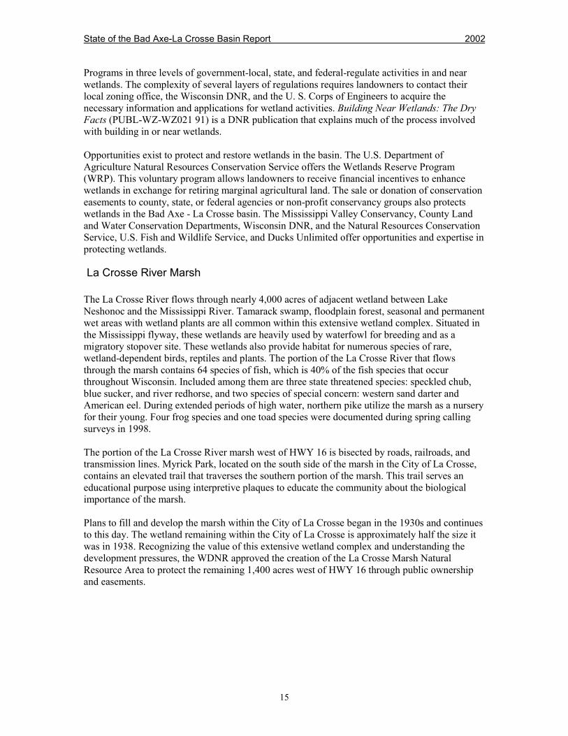
Figure 10. La Crosse River Marsh
The La Crosse River marsh locatedeast of HWY 16 includesapproximately 2,500 acres of publicand private land between La Crosseand West Salem. The MississippiValley Conservancy, a private, locallybased, non-profit land trust, isworking with local landowners, theWisconsin DNR, and the NaturalResources Conservation Service(NRCS) to protect and enhance thisportion of the La Crosse River marsh.The Mississippi Valley Conservancyuses conservation easements, landdonations, cooperative acquisitionsand a landowner registry program toconserve lands for ecological, scenic,and open space values. Approximately350 acres of marsh is permanentlypreserved as wetland within what iscalled the La Crosse RiverConservancy Area, east of HWY 16.[www.centurytel.net/mvc]
Storm sewers that drain portions of LaCrosse and Onalaska containnumerous discharge points to the La Crosse River and associated marsh. Communities within theLa Crosse urbanizing area will each receive a Wisconsin DNR stormwater discharge permit in2002. The purpose of the permit is to improve the water quality of stormwater reaching the state'swetlands, rivers, streams, and groundwater.
Agricultural Lands
Agricultural lands of the Bad Axe - La Crosse basin total approximately 275,000 acres, which is36% of the entire basin. Due to the steep topography of the basin, agricultural land in the basin isconfined to the valley floors and wide ridgetops. Slopes too steep to crop or pasture sustain aforest canopy. Soil loss from farm land was a devastating problem until soil conservationmeasures were implemented in the 1930's and 40's. Cropping along the contours of the slopedlands was one measure that greatly reduced the loss of valuable soil. The characteristic strips ofdifferent crops in gentle curves around hills and through valleys is a common site in the basin tothis day. Soil conservation remains an important objective of farmers in the basin today.
The Coon Creek, Bad Axe River and Rush Creek watersheds are dominated by moderate to heavysilt loam soils, which are generally well drained. The La Crosse River basin contains soils that arewell to excessively drained loamy sands and silt loams. These soil types lend themselves well toagricultural crops if erosion is minimized.
State of the Bad Axe-La Crosse Basin Report 2002
17
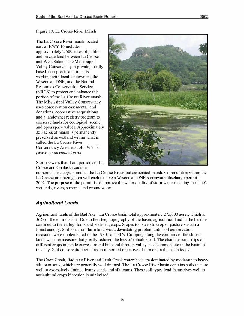
Figure 11. Birds eye viewof contour strips in LaCrosse County.
The average size farm in thefour counties found in theBad Axe - La Crosse basinwas 214 acres in 1997, downfrom 221 acres in 1992.Between 1992 and 1997, thefour counties lost 200working farms, however thetotal acreage in agriculturalproduction did not decreasesignificantly. Even with a12.8% decrease in totalnumber of beef and milkingcows in the four counties, concentrations of livestock have increased on some farms. Acreage inhay and alfalfa dominates the agricultural landscape of the basin, followed by corn, soybeans, andoats. Small amounts of tobacco, vegetables, and potatoes are also grown in the basin.
Public Lands
Not everyone who enjoys the outdoors is able to own their own piece of land. The purchase ofprivate land from willing sellers for public use is important not only for the citizens of the state,but also for the plants, wildlife, natural history, and future of the State of Wisconsin. Federal,state, county, and city governments all own land for use, enjoyment, and protection of its naturalbeauty, ecological and geological significance, fish and wildlife resources. Three state bike trails,five state natural areas and three state fishery areas are found within the Bad Axe-La Crosse Riverbasin.
State Natural Areas (SNAs) are formally designated sites owned by the Wisconsin Departmentof Natural Resources, which are devoted to scientific research, the teaching of conservationbiology, and the preservation of genetic diversity of plants and animals native to Wisconsin. Theyare not intended for intensive recreational use. Five State Natural Areas have been established inthe Bad Axe-La Crosse River basin.
State Fishery Areas are acquired by the Wisconsin Department of Natural Resources to protectimportant waterways in Wisconsin and provide access for fishing to all citizens. State FisheryAreas consist of land owned by the Wisconsin DNR or private land where the Wisconsin DNRhas acquired easements along various streams. An easement is generally no larger than a 66 footwide corridor along both sides of a stream where only fishing, hiking and nature observation isallowed. It is important to remember that on easements the land is owned by private individuals,not by the State. There are three State Fishery Areas in the Bad Axe-La Crosse River Basin: CoonCreek State Fishery Area, La Crosse River State Fishery Area, and the La Crosse ComprehensiveFishery Area. These fishery areas include state ownership and/or streambank easements onnumerous streams.
State of the Bad Axe-La Crosse Basin Report 2002
18
National Public Lands border the western edge of the Bad Axe-La Crosse River Basin. TheUpper Mississippi River Fish and Wildlife Refuge begins north of the Bad Axe - La Crosse Riverbasin at the Chippewa River and extends south 261 miles to Rock Island, IL. The U.S. Fish andWildlife Service owns and manages nearly 200,000 acres of wooded islands and backwaters ofthe Mississippi River. The refuge is administered by the U.S. Fish and Wildlife Service to protectand preserve habitat needed for migratory birds, fish and other wildlife. Millions of migratorybirds, including ducks, geese and swans, rest and feed on the refuge during spring and fallmigrations, and hundreds of bald eagles winter along the river. The popularity of a variety ofrecreational activities on the river has made this a heavily used refuge. Voluntary closed areas areestablished in some portions of the refuge to protect nesting and migratory wildlife, but mostareas are open to hunting, fishing and general recreation. [www.umesc.usgs.gov/umr_refuge.html]
Other Federally owned lands in the basin are within the Fort McCoy Military Reservation, justeast of Sparta in Monroe County. This property encompasses approximately 60,000 acres.Access to portions of this military reservation are available for recreation, hunting and fishing bypermission from Fort McCoy.
Public Lands in Crawford County within the Bad Axe - La Crosse River Basin
La Crosse Comprehensive Fishery Area: Names of properties in Crawford County includeportions of Sugar Creek and Copper Creek. These DNR properties can be used for fishing, natureobservation, and photography.
Prairie du Chien Savanna State Natural Area: 213 acres of high quality savanna, dry prairie,and oak woodlands. Several state endangered and threatened plants occur on the property. It isone of the few remaining undeveloped bluffs overlooking the Mississippi River in the Prairie duChien area.
Rush Creek State Natural Area: This 1806-acre natural area in the Rush Creek Watershed(BL01) is owned by the Wisconsin DNR. It is located 1.2 miles northwest of Ferryville on Hwy35 and Rush Creek Road. A trail to the bluff top begins at the parking lot on Rush Creek Road.The outstanding feature of this natural area is a series of dry prairies on the steep limestonecapped bluffs paralleling the Mississippi River. The prairie remnants are part of the mostextensive series of “goat prairies” left in Wisconsin that host a nearly complete range of dryprairie plant species. The part of this SNA without southwest exposures contain red and whiteoak-dominated woods. A significant amount of black walnut, hickory, basswood, silver maple,and aspen are also present with the oak. A lowland forest of silver maple, elm, cottonwood, riverbirch and willow grows along Rush Creek. Animals common to the area include several raptorspecies, numerous songbird species, timber rattlesnakes, ruffed grouse, turkey, deer, squirrel,raccoon, muskrat, and beaver.
Rush Creek Streambank Protection Area: This 345-acre area includes Rush Creek and CooleyCreek, both high quality trout streams, in Crawford and Vernon Counties. The goal of theWisconsin DNR Streambank Protection Program is to protect in-stream habitat and water qualityby acquiring riparian land or easements in need of restoration. Protection and improvementactions include in-stream habitat structures, access improvements, bank stabilization, and re-vegetation of raw banks.

State of the Bad Axe-La Crosse Basin Report 2002
19
Public Lands in La Crosse County within the Bad Axe - La Crosse River Basin
City of La Crosse Major Parks: Copeland Park, Grandad Bluff, Green Island Park, Houska Park,Pettibone Park, Red Cloud Park and Riverside Park are all major La Crosse city parks locatedwithin the Bad Axe - La Crosse River Basin. Many more smaller neighborhood parks are foundthroughout the City.
City of Onalaska Major Parks: Glen Fox Park, Onalaska Community Park and Rowe Park areOnalaska City parks located within the Bad Axe - La Crosse River Basin. Many more smallerneighborhood parks are found throughout the City.
Coulee Experimental State Forest: This 2,972-acre area in the Lower and Little La Crosse RiverWatersheds (BL04 & BL05) is owned by the Wisconsin DNR. A parking lot is located off CTHII, south of Bangor and another small parking lot exists at the end of Russlan Coulee Road offCTH M. This land was purchased to study watershed management and forestry practices in thecoulee region. Currently the land is open for hunting, cross-country skiing, hiking and horsebackriding. Camping and campfires are not permitted. Principle game species of this area includedeer, ruffed grouse, squirrels, turkeys and rabbits. Timber rattlesnakes are also present. Thehabitat within the forest consists primarily of upland timber and open fields. Statewide huntingregulations apply.
Goose Island Park: This 710-acre park is leased by La Crosse County from the U.S. Army Corpsof Engineers. The park is approximately five miles south of La Crosse on HWY 35. The island issurrounded by federally owned land in the Upper Mississippi River Fish and Wildlife Refuge.Park visitors will find three boat ramps, camping (tent and electrical sites), showers, flush toilets,sheltered picnic areas, grills and picnic tables. Hiking trails and a six mile canoe trail are alsomaintained for visitors.
Great River State Trail: This 24-mile trail traverses both the La Crosse-Bad Axe River Basin andthe Black-Buffalo-Trempealeau River Basin. There are 130 acres with 2 miles of trail in the LaCrosse-Bad Axe Basin and 138 acres with 22 miles of trail in the Black-Buffalo-TrempealeauBasin. The limestone screening trail was formerly the Chicago and Northwestern Railroad bed.This trail travels through a mixture of prairie and wet bottomlands between Onalaska in LaCrosse County and Marshland, in Buffalo County. A variety of wildlife can be seen throughoutthe year. The trail is used for walking, hiking, biking, cross-country skiing, snowmobiling,fishing and photography. The trailhead office with parking is located at Oak Street in Onalaska.Parking and access to the Great River State Trail are also located at Midway, Lytles Landing,Trempealeau, Marshland, Perrot State Park, and the Trempealeau National Wildlife Refuge.Currently the Great River Trail is not directly linked to the La Crosse River Trail by a dedicatedtrail, but rather by local roads and La Crosse City bike trails. A trail pass is required for bikers 16years of age and older. [www.tourism.onalaska.wi.us/bike.html]
State of the Bad Axe-La Crosse Basin Report 2002
20
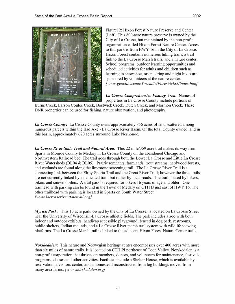
Figure12: Hixon Forest Nature Preserve and Center(Left). This 800-acre nature preserve is owned by theCity of La Crosse, but maintained by the non-profitorganization called Hixon Forest Nature Center. Accessto this park is from HWY 16 in the City of La Crosse.Hixon Forest contains numerous hiking trails, a traillink to the La Crosse Marsh trails, and a nature center.School programs, outdoor learning opportunities andscheduled activities for adults and children such aslearning to snowshoe, orienteering and night hikes aresponsored by volunteers at the nature center.[www.geocities.com/Yosemite/Forest/8488/index.htm]
La Crosse Comprehensive Fishery Area: Names ofproperties in La Crosse County include portions of
Burns Creek, Larson Coulee Creek, Bostwick Creek, Dutch Creek, and Mormon Creek. TheseDNR properties can be used for fishing, nature observation, and photography.
La Crosse County: La Crosse County owns approximately 856 acres of land scattered amongnumerous parcels within the Bad Axe - La Crosse River Basin. Of the total County owned land inthis basin, approximately 670 acres surround Lake Neshonoc.
La Crosse River State Trail and Natural Area: This 22 mile/359 acre trail makes its way fromSparta in Monroe County to Medary in La Crosse County on the abandoned Chicago andNorthwestern Railroad bed. The trail goes through both the Lower La Crosse and Little La CrosseRiver Watersheds (BL04 & BL05). Prairie remnants, farmlands, trout streams, hardwood forests,and wetlands are found along the limestone screening trail. The La Crosse River Trail is aconnecting link between the Elroy-Sparta Trail and the Great River Trail; however the three trailsare not currently linked by a dedicated trail, but rather by local roads. The trail is used by hikers,bikers and snowmobilers. A trail pass is required for bikers 16 years of age and older. Onetrailhead with parking can be found in the Town of Medary on CTH B just east of HWY 16. Theother trailhead with parking is located in Sparta on South Water Street.[www.lacrosseriverstatetrail.org]
Myrick Park: This 13 acre park, owned by the City of La Crosse, is located on La Crosse Streetnear the University of Wisconsin-La Crosse athletic fields. The park includes a zoo with bothindoor and outdoor exhibits, handicap accessible playground, fenced in dog park, restrooms,public shelters, Indian mounds, and a La Crosse River marsh trail system with wildlife viewingplatforms. The La Crosse Marsh trail is linked to the adjacent Hixon Forest Nature Center trails.
Norskedalen: This nature and Norwegian heritage center encompasses over 400 acres with morethan six miles of nature trails. It is located on CTH PI northeast of Coon Valley. Norskedalen is anon-profit corporation that thrives on members, donors, and volunteers for maintenance, festivals,programs, classes and other activities. Facilities include a Shelter House, which is available byreservation, a visitors center, and a homestead reconstructed from log buildings moved frommany area farms. [www.norskedalen.org]
State of the Bad Axe-La Crosse Basin Report 2002
21
Swarthout Park: This 20-acre park is owned by La Crosse County. The park is located on thenorthwest end of Lake Neshonoc on the eastern edge of West Salem. The park is located alongthe lake shore just above the dam and along the south shore of the La Crosse River below thedam. The park entrance is on HWY 16. Visitors will find a picnic shelter, tables, grills, vaulttoilets, hand pump, grass volleyball court, playground apparatus, beach, and one boat ramp with apier. Across HWY 16 and below the dam, there is a canoe launch area to the La Crosse River.Wildlife food plots and natural wetlands are near the canoe launch parking area.
Veterans Memorial Park: This 210-acre park is owned by La Crosse County on the western edgeof West Salem. Access to the park is from HWY 16. The park is adjacent to the La Crosse Riverand contains one canoe launch. Access to the La Crosse River State Trail is gained through a trailextension that begins within the park. Visitors to the Veterans Memorial Park will find shelteredpicnic areas, camping sites (tent and electrical), camp store, vault and flush toilets, ball diamonds,and volleyball courts. A small fishing pond is found near the park entrance.[www.lacrosseriverstatetrail.org/vets.htm]
Public Lands in Monroe County within the Bad Axe - La Crosse River Basin
Elroy-Sparta State Trail: The first eight miles of this 32-mile trail is in the Little La CrosseWatershed (BL05) of the La Crosse-Bad Axe Basin. The rest of the trail travels through portionsof the Central Wisconsin River Basin and the Lower Wisconsin River Basin. The Elroy-SpartaTrail is found along Hwy. 71 between Elroy, in Juneau County, and Sparta, in Monroe County,on the abandoned Chicago and Northwestern Railroad bed. This 'granddaddy of all trails' was thefirst official rails to trails conversion in the U.S. in 1965. The limestone screening trail passesthrough three rock-tunnels. The Kendall and Wilton tunnels are ¼ mile long and the Norwalktunnel is ¾ mile long. The tunnels are closed November 1-May 1. Bikers, hikers, andsnowmobilers use the trail. A trail pass is required for bikers 16 years of age and older.[www.elroy-sparta-trail.org]
Espe Fishing Pond: This 84-acre area located in the Little La Crosse River Watershed (BL05) isowned by the Wisconsin DNR. A one acre fishing pond with handicap access and parking area islocated on the property. The Little La Crosse River, a Class II trout stream, flows through theproperty. However, an extensive wetland makes reaching the river difficult from the Espe FishingPond parking lot. Espe Pond is accessible from HWY 27 between Leon and Melvina. The area issubject to statewide hunting and fishing regulations.
Eureka Maple Woods State Natural Area: This 36 acre state natural area located in the CoonCreek Watershed (BL03) is owned by the Wisconsin DNR. It is located on steep slopes adjacentto the Coon Creek Fisheries Area along Rullands Coulee Creek on Oakdale Ave. Diverse plantand bird species inhabit the steep slopes dominated by sugar maple and basswood.
Farmers Valley Creek Fishery Area: This 138-acre fishery area south of Sparta in the Little LaCrosse River Watershed (BL05) is owned by the Wisconsin DNR. This fishery area is accessiblefrom Jefferson Road and CTH AA. Farmers Valley Creek, a Class I trout stream, flows throughthe property. The area is subject to statewide hunting and fishing regulations.
State of the Bad Axe-La Crosse Basin Report 2002
22
La Crosse Comprehensive Fishery Area: Names of properties in Monroe County includeportions of Farmer’s Valley Creek and Little La Crosse River. These DNR properties can be usedfor fishing, nature observation, and photography.
La Crosse River Fishery Area: This 463-acre fishery area in the Upper La Crosse RiverWatershed (BL06) is owned by the Wisconsin DNR. It is located two miles northeast of Angelo,adjacent to the Fort McCoy Military Reservation. It is open to fishing and hunting. Statewidehunting and fishing regulations apply. Principle game species of this area include waterfowl,turkeys, squirrels, ruffed grouse, deer, and rabbits. The La Crosse River, a Class II trout stream,flows through the fishery area.
Monroe County: Monroe County owns approximately 300 acres of land scattered amongnumerous parcels within the Bad Axe - La Crosse River Basin.
Pinnacle Rock Fishing Pond: This 55-acre area located in Little La Crosse River Watershed(BL05) is owned by the Wisconsin DNR. A 2-acre trout pond is found on the property, which isopen to public fishing. The pond is on a tributary to the Little La Crosse River. It is locatedsoutheast of Melvina in the Township of Jefferson at the end of Marshall Road. Statewidehunting and fishing regulations apply.
Public Lands in Vernon County within the Bad Axe - La Crosse River Basin
Battle Hollow & Battle Bluff State Natural Area: This 241-acre natural area in the Rush CreekWatershed (BL01) is owned by the Wisconsin DNR. It is located 2.5 miles north of DeSoto atHwy 35 and Battle Hollow Road. Battle Bluff, on the north side of the intersection of Hwy 35and Battle Hollow Road, is an excellent example of a southern exposure goat prairie. BattleHollow is found on the south side of Battle Hollow Road. The area contains dry prairie, southerndry forest, and oak savanna communities. The vegetation is diverse since there is both limestoneand sandstone present. The entire area was the site of one of the Black Hawk War battles.
Coon Creek Cliffs State Natural Area: This 30-acre natural areain the Coon Creek Watershed (BL03) is owned by WisconsinDNR. This area is located northeast of Coon Valley at theintersection of CTH P and Spring Coulee Ridge Road. Thisnatural area contains a young population of paper birch and cliffsbordering Coon Creek.
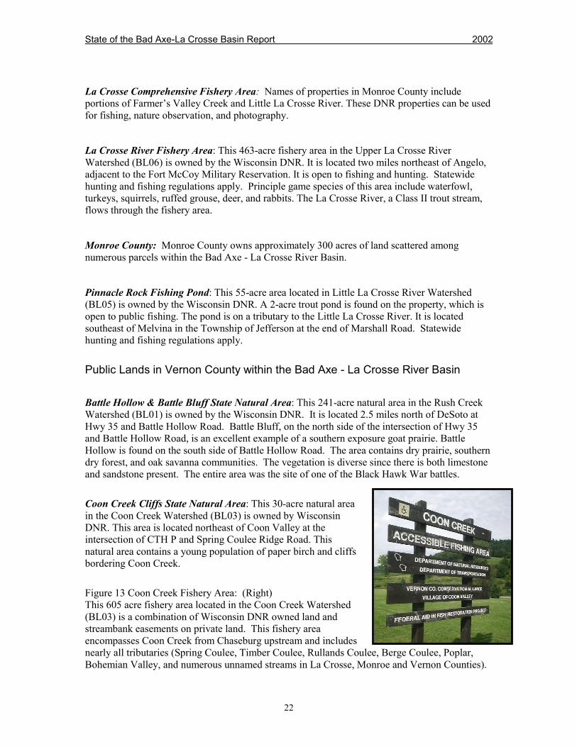
Figure 13 Coon Creek Fishery Area: (Right)This 605 acre fishery area located in the Coon Creek Watershed(BL03) is a combination of Wisconsin DNR owned land andstreambank easements on private land. This fishery areaencompasses Coon Creek from Chaseburg upstream and includesnearly all tributaries (Spring Coulee, Timber Coulee, Rullands Coulee, Berge Coulee, Poplar,Bohemian Valley, and numerous unnamed streams in La Crosse, Monroe and Vernon Counties).

State of the Bad Axe-La Crosse Basin Report 2002
23
The DNR owned land is open to fishing and hunting, but the easements only allow fishing,hiking, and nature observation. Statewide hunting and special trout fishing regulations apply.Principle game species include ruffed grouse, deer, squirrel and wild turkey. Handicap accessibletrout fishing is available on Coon Creek at the Coon Valley Park off STH 14/61.
Duck Egg County Park: This 706-acre Vernon County park is located 10 miles west of Viroquaon Irish Ridge Road, off CTH Y in the Bad Axe River Watershed (BL02). The SpringvilleBranch of the Bad Axe River flows through this park. Duck Egg offers fishing, hunting, hiking,and equestrian trails. A large, dry flood control dam is also found on the property.
Rentz Memorial Park (Esofea County Park): This 56-acre Vernon County park is located 9miles northwest of Viroqua, just off CTH B in the Bad Axe River Watershed (BL02). The NorthFork Bad Axe River flows through the park and a trout pond is located on the property. RentzMemorial Park offers fishing, camping, hiking, picnic areas and a soccer field.
Sidie Hollow County Park: This 489-acre Vernon County park is located 3 miles west of Viroquaon CTH XX in the Bad Axe River Watershed (BL02). The park offers camping, hiking,picnicking, hunting, and fishing. The 40-acre lake in the park is an impoundment created by adam built across the South Fork of the Bad Axe River as a PL566 flood control project.
Vernon County: Vernon County owns approximately 762 acres of land within the Bad Axe - LaCrosse River Basin. Duck Egg County Park contains the majority of this acreage and RentzMemorial Park contains the balance.
State of the Bad Axe-La Crosse Basin Report 2002
24
References – Chapter 2
1. Fort McCoy. 2000. Fort McCoy Integrated Natural Resources Management Plan Effective2000-2005. Prepared by Directorate of Training and Mobilization, Range Division, Biologicaland Cultural Resources Management Team. Fort McCoy, Wisconsin.
2. La Crosse County. 2000. La Crosse County Land Atlas and Plat Book. Cloud Cartographics,Inc.
3. La Crosse County Natural Resources Conservation Service (NRCS). 1995. AerialPhotography of La Crosse County.
4. Mississippi Valley Conservancy. December 12, 2000. Mississippi Valley Conservancy WebPage. www.centurytel.net/mvc.
5. Monroe County. 2001. Monroe County Land Atlas and Plat Book. Cloud Cartographics, Inc.
6. Vernon County. 2001. Vernon County Land Atlas and Plat Book. Cloud Cartographics, Inc.
7. WDNR. 1994. Fishing and Boating on the Mississippi River. Publication FM-745-94.
8. WDNR. May, 1995. Wisconsin’s Biodiversity as a Management Issue. A Report toDepartment of Natural Resources Managers. PUB-RS-915 95
9. WDNR. August 10, 1998. La Crosse Marsh Natural Resources Area Feasibility Study. LaCrosse WDNR Service Center.
10. WDNR. 1998. Unreported data. Spring Frog Calling Surveys of La Crosse River MarshBetween Hwy 16 and West Salem. La Crosse WDNR Service Center
11. WDNR. March, 2000. Reversing the Loss. A Draft Strategy for Protecting and RestoringWetlands in Wisconsin.
12. WDNR. November 2000. Wisconsin Forests at the Millennium. PUB-FR-161 2000.
13. Wisconsin Governor's Forestry Council. Undated. Questions and Answers about WisconsinForests. Fey Publishing, Wisconsin Rapids, WI.