chapter 2: facility environmental inventory · 2019-03-26 · grand forks international airport:...
TRANSCRIPT

Grand Forks International Airport: Airport Master Plan February 2016 DRAFT Chapter 2 – Facility & Environmental Inventory Page 2-1
CHAPTER 2: FACILITY & ENVIRONMENTAL INVENTORY
Introduction
The Inventory chapter of the Airport Master Plan for the
Grand Forks International Airport (GFK) provides the
baseline framework to evaluate the airport facility. The
facility inventory provides a review of the existing social
and built environment to formulate profiles of the
community and airport. The environmental inventory
provides data to identify key environmental constraints
and planning considerations that may affect airport
development according to National Environmental
Policy Act (NEPA) guidelines.
This inventory data collection will be used to compare the existing conditions to the airport needs
determined in future sections of the plan. This will lead to a plan developed for the future of the
airport. Background information and data is gathered from various sources and compiled into this
chapter. Please refer to the various appendices referenced within this narrative for more detailed
information.
This chapter provides an inventory of the following elements:
Background
Facility Inventory
o Land
o Airfield Facilities
o NAVAIDS & Airspace
o Commercial Passenger Terminal
o General Aviation
o Air Cargo
o Support Facilities
o Ground Access, Circulation & Parking
o Other
Surrounding Land Use
Financial Overview
Environmental Inventory
Socioeconomic Data
Background
General
The Grand Forks International Airport: Mark Andrews Field (FAA ID: GFK), is the 22nd busiest airport in
the United States in terms of operations. It is located in Grand Forks County in northwestern North
Dakota. This airport is classified by FAA as a primary non-hub commercial service airport. The airport
provides scheduled passenger service, air cargo, complete general aviation services and U.S. Customs
and Border Protection services. The airport served 303,871 flight operations and enplaned 146,717
passengers in Fiscal Year (October 1, 2014 to September 30, 2015), and processed 58 million pounds of
freight and mail in 2014.
Airport Entrance Sign

Grand Forks International Airport: Airport Master Plan February 2016 DRAFT Chapter 2 – Facility & Environmental Inventory Page 2-2
Location
The city of Grand Forks is located in northeastern
North Dakota, 80 miles south of the Canadian border.
Grand Forks is located approximately 80 driving miles
north of Fargo, North Dakota; 146 driving miles south
of Winnipeg, Manitoba, Canada; and 315 miles
northwest of Minneapolis, Minnesota. The city is
located along US Interstate 29 which runs from the
Canadian border south to Texas. Grand Forks is
located along the Red River of the North separating
Grand Forks from East Grand Forks, MN.
GFK is located five miles northwest of the Grand
Forks central business district in Rye Township. The
airport itself is within a disconnected portion of Grand Forks city limits. U.S. Highway 2 (Gateway
Drive) and Airport Drive provide access to the airport facility. U.S. Highway 2 is an east-west four-lane
roadway providing direct access from the airport to downtown Grand Forks. Figure 2-1: Airport
Location Map depicts the airport’s location locally and regionally.
Setting
Grand Forks is located in an area of farmland and tallgrass prairie ecosystems. The community is within
the heart of the Red River Valley, a formation left behind from glacial Lake Agassiz. The area is known
for fertile lands. This area is prone to seasonal flooding.
The airport is sited on relatively flat land at 844 feet above Mean Sea Level (MSL). On-airport land use
includes agricultural production, and some grassland. The airport is surrounded by grassland and
agricultural land. Rural residential developments are scattered around the airport and a wastewater
sewage lagoon located to the northeast. An auto-parts company exists directly east of the airport.
Grand Forks city limits are located approximately 2 miles east of airport property along U.S. Highway
2. Terrain maintains relatively the same elevation throughout the airfield (within +/- 10 feet) with
general drainage flowing to the north. Figure 2-5: Land Use Map depicts the airport’s local setting in
reference to surrounding land uses. See Environmental Inventory section for more details on specific
environmental resources.
Climate
Grand Forks is located within a humid continental climate zone with mild summers and cold, harsh
winters. The Grand Forks average annual temperature is 40.6 degrees Fahrenheit with annual
precipitation of 20.45 inches of precipitation with 38.9 inches of snowfall. The area experiences wide
temperature extremes. Snowfall on average occurs from October through April. Prevailing winds are
from the north-northwest. See Meteorological Data section for more details on local weather conditions
that affect the design of airport facilities.
Exhibit 2-1 – Statewide Airport Location
Source: U.S. Census Bureau

")4
")5
Grand Forks International
Airport
Grand Forks Central Business District (4 miles)
")5
£¤2
´ Grand Forks International AirportAirport Master Plan
Airport Location MapFigure 2-1
*Intended for Planning Purposes OnlyP:\Air
port\N
D\Gr
andF
orks\P
rojec
ts\14
5151
00\G
IS\GI
S_MP
\_Map
s\Airp
ort_L
ocati
on_M
ap.m
xd TL
G 2/1
6/201
6
LegendCounty HighwayUS/State Highway
Existing Airport PropertyGrand Forks City Limits
0 1 20.5Miles
!(
NiagaraEmerado
Larimore
ThompsonNorthwoodReynolds
InksterManvel
Gilby
BeltramiClimax
Crookston
EastGrandForks
Erskine
Fertile
Fisher
Fosston
Gully
Lengby
McIntoshMentor
Nielsville
Trail
Winger
WalshCounty
TraillCountySteele
County
Marshall
PenningtonCounty
Red LakeCounty
NormanCounty
MahnomenCounty
GrandForks
GrandForks
County
PolkCounty
Red River ofthe North
!!
!
!
!
^! !
!CanadaWinnipeg
FargoBismarck
OntarioManitobaSaskatchewan
MontanaMinnesota
South Dakota
North Dakota
PierreRapid CitySioux Falls
Minneapolis
Grand Forks
Billings
Local Map
Regional Map Grand Forks Metropolitan Statistical Area (MSA)

Grand Forks International Airport: Airport Master Plan February 2016 DRAFT Chapter 2 – Facility & Environmental Inventory Page 2-4
Socioeconomics
The city of Grand Forks has an estimated population of 56,057 in 2014. Population within the Grand
Forks-East Grand Forks Metropolitan Statistical Area (MSA) which includes two counties surrounding
Grand Forks is estimated to be 101,842. After years of steady population or even slightly declining
population in the 1990s and 2000s, the Grand Forks MSA is growing again with a 0.67 percent annual
growth rate from 2010 to 2015. It is believed the economic resurgence was caused indirectly from the
oil boom in western North Dakota. Greater Grand Forks has a diverse economy including
government/defense, health care, retail trade/accommodation/food service, construction and
agricultural-related manufacturing industries. The region has a low unemployment rate of 2.3 percent
as of September 2015. See Socioeconomic Data section for more details.
Airport Ownership & Management
In May 1987, a Joint Resolution of Grand Forks County and the city of Grand Forks authorized the
creation of the Grand Forks Regional Airport Authority as the owner and operator of the Grand Forks
International Airport/Mark Andrews Field. The Airport Authority Board and staff is responsible for the
airport’s operation and maintenance. The Airport Authority works cooperatively with staff from Grand
Forks County and the city of Grand Forks. The day-to-day airport management is handled by Airport
Authority staff led by the Executive Director.
GFK indirectly employs nearly 750 people making the airport the 7th largest employer in Grand Forks.
Airport History
Prior to the airport’s existing location, the city’s
original airport was located much closer to city
limits. The present airport was activated in
December 1963 and became fully operational on
February 1, 1964.
By the late 1950’s and early 1960’s, the original
airport (located east of what is now Interstate 29 and
south of U.S. Highway 2) was unable to accommodate
larger commercial air service aircraft. Community
debate was held on whether or not to expand the
existing airport or if the construction of a new airport
was a better option for the future of Grand Forks. It was determined to be more cost-effective for the
airport to be relocated as the State Highway Department offered to purchase some of the existing land
for future highway right-of-way use. In January 1961, the city of Grand Forks voted to construct a new
airport five miles west of the city. Jet service was introduced to Grand Forks in 1965.
Other major milestones in the GFK history include:
Relocated the “dome” hangar to the new airport site where the University of North Dakota’s
John D. Odegard school of Aerospace Sciences first began (1968)
Main runway extended and strengthened to accommodate the Boeing 727 (1970)
Aprons strengthened for greater air carrier traffic demand (1982)
Third runway (17L/35R) completed to accommodate flight training operations (1983)
Multiple terminal building expanded for greater capacity (1974, 1985, 1993)
More information on the GFK airport history can be found at http://gfkairport.com/history/.
Since the last Airport Layout Plan was completed at GFK in 2008, several airport capital improvement
development projects have been completed. Major projects include:
Original Grand Forks Airport
Grand Forks International Airport: Airport Master Plan February 2016 DRAFT Chapter 2 – Facility & Environmental Inventory Page 2-5
Construction of Runway 9R/27L (2009)
Construction of 50,000 S.F. Byron L. Dorgan Terminal Complex (2010)
Development of Electronic Airport Layout Plan (2012)
University of North Dakota Helicopter Hangar Construction (2012)
Demolition of old Air Carrier Terminal Building (2013)
Construction of Employee Airport Terminal Parking Lot (2013)
Construction of New Snow Removal Equipment (SRE) Building (2014)
Construction of Overflow Automobile Parking Lot (Lot C) (2014)
Air Cargo Building Expansion (2014)
Reconstruct Taxiway A, B, & D Intersection (2015)
Construction of New Aircraft Rescue and Fire Fighting (ARFF)/Operations Building (2016)
A complete list of major airport development projects from FAA and the State can be found in
Appendix X: Airport Funding & History.
Airport Role & Design
GFK provides vital aeronautical functions for the public’s best interest including commercial air
service, air cargo, complete general aviation services and a U.S. Customs Port of Entry. The airport
also serves to train professional pilots as it houses one of the world’s premier flight schools run by the
University of North Dakota (UND).
GFK serves aviation demands for the Grand Forks-East Grand Forks metropolitan and surrounding areas
in North Dakota and Minnesota. GFK attracts airline passengers from northeastern North Dakota,
northwestern Minnesota and southern Manitoba. Other surrounding airports providing scheduled
commercial air carrier service include Fargo (80 miles), Thief River Falls (56 miles) and Devils Lake (85
miles).
Table 2-2 – Area Commercial Service Airports
Airport Name / City FAA ID Location from GFK
2013 Enplanements
FAA Classification
Grand Forks Int’l GFK - 146,435 Primary Non-Hub
Thief River Falls Regional TVF 56 miles 2,152 Non-Primary
Fargo – Hector Int’l FAR 80 miles 403,919 Primary Small-Hub
Devils Lake Regional DVL 85 miles 2,679 Commercial Service
Bemidji Regional BJI 118 miles 22,819 Primary Non-Hub
Winnipeg Int’l YWG 151 miles 1,678,899 N/A
Minneapolis-St. Paul Int’l MSP 328 miles 16,280,835 Primary Large Hub Source: Airnav.com, FAA Airport Master Record, FAA CY 2013 ACAIS
The airport is part of the National Plan of Integrated Airport Systems (NPIAS) as classified by the
Federal Aviation Administration (FAA). NPIAS airports are vital to the national air transportation
system. According to FAA standards, the airport is classified as a non-hub primary commercial airport
enplaning more than 10,000 passengers but less than 0.05 percent of national total. Appendix X:
Airport Classification contains more information on this topic with Chapter 6: Implementation
providing additional information about the Federal funding programs available to the Grand Forks
Regional Airport. The airport is certificated under FAR Part 139 guidelines as a Class I airport
certificated to serve scheduled operations of large air carrier aircraft.
The North Dakota State Aviation System Plan (NDSASP), completed by the North Dakota Aeronautics
Commission (NDAC) in 2015, also categorized GFK as a primary commercial service airport. GFK
supports the national and state aviation system by providing communities with access and international
markets in multiple states and throughout the United States.

Grand Forks International Airport: Airport Master Plan February 2016 DRAFT Chapter 2 – Facility & Environmental Inventory Page 2-6
The FAA’s Airport Reference Code (ARC) identifies a design category based on aircraft wingspan, tail
height and approach speed for aircraft types that regularly use the airport. The last FAA-approved GFK
Airport Layout Plan prepared in 2008 identifies the ARC classification of C-IV. An example aircraft in
the ARC C-IV category would be an Airbus A300/A310. These aircraft types are currently operated at
GFK by FedEx. Although not identified on the ALP, the existing taxiway design group (TDG) width is
TDG-5 for the design aircraft. See Chapter 4: Facility Requirements for more details on FAA design
classifications.
Table 2-3 – Airport Role & Design
Airport ID State Classification FAA Classification ARC TDG
GFK Primary Commercial Service Primary Non-Hub
Commercial Service C-IV 5
Source: Federal Aviation Administration, ND State Aviation System Plan (2015), GFK Airport Layout Plan ARC = Airport Reference Code, TDG = Taxiway Design Group
It should be noted however the current aircraft types that regularly use the airport have an ARC
classification of D-IV and TDG-5. More information on the design aircraft can be found in Chapter 3:
Aviation Activity Forecasts.
Airport Activity
PASSENGER AIRLINES
The Grand Forks International Airport
provides scheduled airline service through
Delta Air Lines (operated by regional
subsidiaries Skywest/Endeavor Air) and
through Allegiant Airlines. Delta/Northwest
has been operating to Grand Forks since the
1930s and Allegiant began operations in
2008. Scheduled airline departures for the
peak month in March 2014 is shown below
where there were 228 scheduled departures. Actual flight schedules vary based on seasonal demand
and airline requirements. Large air carrier charter flights are flown on-demand to leisure destinations
or for UND Athletics.
Table 2-4 – Passenger Airline Service (March 2014)
Airline Destination Frequency Aircraft Types (Seats)
Allegiant (G4) Las Vegas-McCarran (LAS) 4/week MD-83 (166)
Boeing 757-200 (215)
Allegiant (G4) Orlando-Sanford (SFB) 4/week Airbus A-320 (177)
Allegiant (G4) Phoenix-Mesa (AZA) 5/week MD-83 (166)
Airbus A-319 (156)
Delta (DL) Minneapolis-St. Paul (MSP) 5-6/day CRJ-200 (50)*
Sun Country (SY) Laughlin, AZ (IFP) Scheduled Charter (1)
Boeing 737-800 (162)
Source: Bureau of Transportation Statistics T-100 *DL has transitioned to 76-seat CRJ-900 aircraft two times daily on average
Enplanements, or each passenger boarding an aircraft for a specific destination, are recorded and
tracked throughout the year. On an annual basis, GFK has experienced a growth in annual
enplanements since the last Airport Master Plan in 2008. Between the years of 2008 and 2013, annual
enplanements at GFK rose from 85,044 to 146,435. This increase of over 70 percent was a result of new
service from Allegiant Airlines and a strengthening regional economy.
Grand Forks International Airport: Airport Master Plan February 2016 DRAFT Chapter 2 – Facility & Environmental Inventory Page 2-7
New service on United Airlines to Denver began in October 2012 but ended in December 2013. Since
2014, Delta has upgraded flights from 50-seat CRJ-200 to 76-seat CRJ-900 aircraft twice-daily on
average.
REGULAR CARGO SERVICE
Grand Forks International Airport is currently home to regular air cargo service featuring a regional hub
for FedEx freight and mail. Mainline air cargo is served by FedEx with feeder service provided by
Corporate Air. Other air cargo operators include IFL, Integrated Air Service (IAS) and others providing
contract feeder service for others carriers.
FedEx is the largest air cargo operator at the airport and conducts ground operations in the south cargo
complex. Daily operations occur with Boeing 757, Airbus A300, or Airbus A310 aircraft. Typically, FedEx
will operate two staggered daily flights. During peak holiday seasons, this can increase to two aircraft
staged on the apron area at any given time. From these operations, Cessna 208 feeder aircraft
(Corporate Air) leave GFK with cargo to smaller outlying cities in North Dakota and northwest
Minnesota. Roughly 8-9 feeder aircraft depart in the morning hours and return in the evening hours in
line with FedEx’s mainline operations conducted in the evenings.
As a part of the FedEx operations, air mail is also sent through mainline aircraft. This mail is then
processed in a separate facility. IAS processes between 50 and 80 thousand pounds of air mail on any
given flight. It has been noted by IAS staff their location on the airfield has sometimes caused issues
with processing their mail and getting it to FedEx in a timely manner.
The airport processed over 58 million pounds of cargo in 2014, an increase of 31 percent from 2007. In
February 2016 FedEx announced it will move its air operations from GFK to Fargo’s Hector International
Airport as soon as October 2016. Air cargo operations are expected to reduce significantly.
GENERAL AVIATION & FIXED BASE OPERATORS
General aviation and small commercial
operators makes up a significant portion of
the airport activity at GFK. Flights are for
various purposes including air
ambulance/medical transport,
business/corporate travel, personal travel,
flight training, recreation and tourism.
AvFlight (formerly GFK Flight Support) is
the airport’s sole Fixed Base Operator
(FBO), and provides aviation services to the public including mobile fueling, ground handling, transient
aircraft storage, hangar leases, pilot lounge, and on-call aircraft maintenance. The FBO complex was
constructed in 2008. AvFlight also handles charter flights and handles ground services for Allegiant’s
regularly scheduled commercial flights.
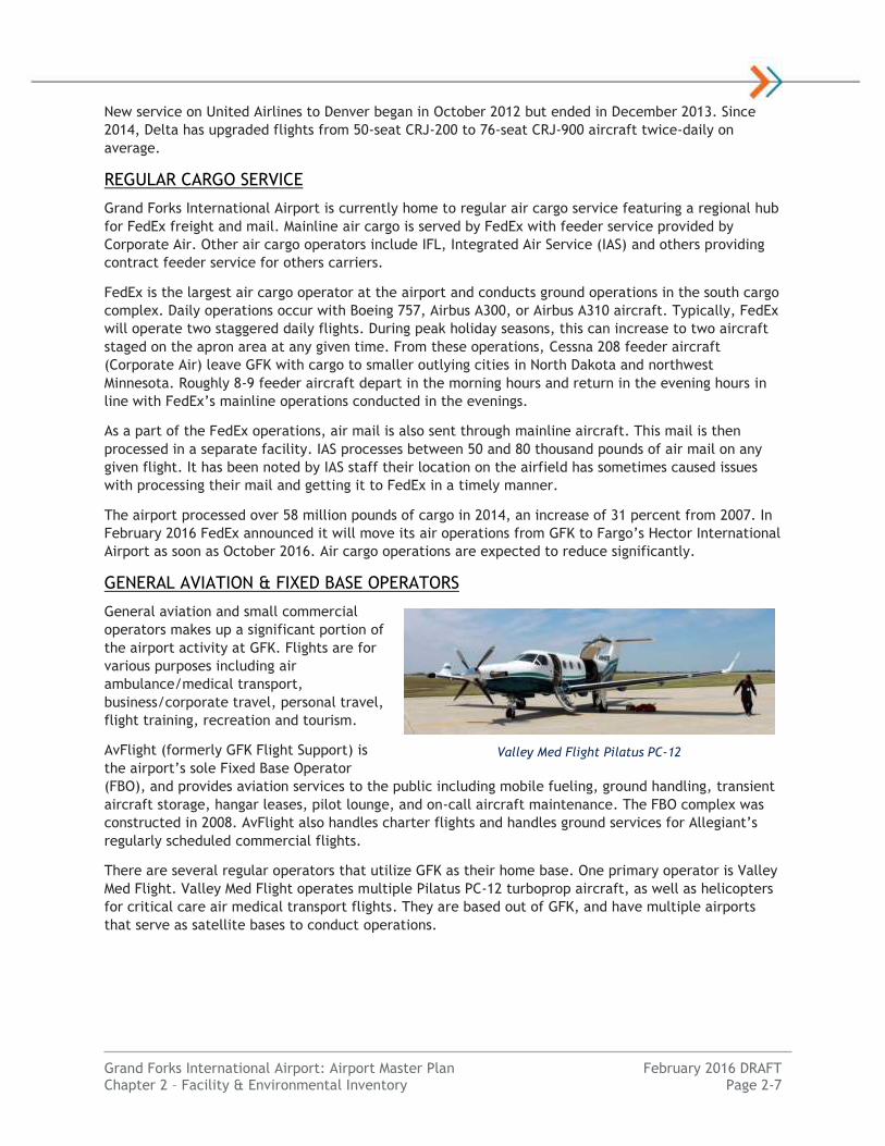
There are several regular operators that utilize GFK as their home base. One primary operator is Valley
Med Flight. Valley Med Flight operates multiple Pilatus PC-12 turboprop aircraft, as well as helicopters
for critical care air medical transport flights. They are based out of GFK, and have multiple airports
that serve as satellite bases to conduct operations.
Valley Med Flight Pilatus PC-12

Grand Forks International Airport: Airport Master Plan February 2016 DRAFT Chapter 2 – Facility & Environmental Inventory Page 2-8
UNIVERSITY OF NORTH DAKOTA
The University of North Dakota John D. Odegard
School for Aerospace Sciences flight training
program is based at GFK. UND operates one of the
world’s largest pilot training programs with a fleet
of flight training aircraft such as single-engine
Cessna 172, multi-engine Piper Seminole and
helicopters. UND provides pilot training for both
traditional students and overseas contract
students. A FAR Part 141 pilot school, students can
obtain numerous pilot certificates and ratings.
UND’s airport operations account for approximately
90 percent of the total takeoffs and landings at
GFK.
OTHER ACTIVITY METRICS
As of December 2015, the FAA Airport Master Record shows a total of 147 based aircraft at GFK. The
majority of these based aircraft are noted as single-engine (95), with 21 multi-engine, 19 jets, and 12
helicopters. UND alone bases 99 aircraft at GFK.
The FAA Terminal Area Forecast (TAF) published in January 2016 indicates there were 303,871 annual
flight operations (takeoff and landings) at GFK in 2015. Approximately 63 percent of these flights were
conducted with the GFK local area, presumably for UND flight training operations. The FAA estimates a
projected annual growth rate of 0.92 percent annually through year 2034.
See Chapter 3: Aviation Activity Forecasts for more information on existing and projected GFK airport
activity.
Faci l ity Inventory
An inventory of Grand Forks International Airport facilities
was performed to establish a baseline for determining
required future improvements. As discussed in the
following sections, GFK airport facilities are grouped into
several categories: land, airfield, navigational aids
(NAVAIDS)/airspace, general aviation, support,
access/parking and other facilities.
Land
The Grand Forks Regional Airport Authority owns approximately 1,770 acres of property fee simple and
additional air easements over non-owned properties. Records show airport land interests were acquired
between 1962 and 2005. The majority of fee ownership was acquired in 1962 when the airport was
relocated outside of city limits and to its present location as it exists today. In June 1988, airport
property transferred ownership from the city of Grand Forks to the Grand Forks Regional Airport
Authority.
Airport land is leased to private parties for approved aeronautical and agricultural (non-aeronautical)
production uses. Examples of lease agreements include land to farmers to maintain large areas of
grassland, lease agreement for aeronautical operators or to individuals construct hangars.
UND Aerospace Fleet Source: University of North Dakota
Grand Forks International Airport: Airport Master Plan February 2016 DRAFT Chapter 2 – Facility & Environmental Inventory Page 2-9
As part of this Master Plan, an update to the Exhibit “A”/Airport Property Map will occur to identify
property ownership, easements and encumbrances. Please see the current Exhibit “A”/Airport Property
Map located in Appendix X: Airport Layout Plan for further details.
Airfield Facilities
Airside facilities are those that are necessary for aircraft surface movement, such as runways,
taxiways, aprons and associated lighting, marking and signage systems. A map depicting existing airport
airside components is included in Figure 2-2: Airfield Facilities Map. Information on design codes is
contained in Appendix X: Airport Classification.
RUNWAY 17R/35L
Runway 17R/35L, the primary runway at GFK, has an existing runway length of 7,351 feet and is 150
feet wide. The runway is designated as an air carrier runway maintained to Part 139 standards. The
runway is currently designed to meet FAA Runway Design Code (RDC) D-IV-5000 (17R) and D-IV-2400
(35L) standards providing operational capability to accommodate larger and faster aircraft and
approach visibility minimums as low as ½ mile. Runway 35L is designed to accommodate a precision
instrument approach while Runway 17R is designed for a non-precision instrument approach with
vertical guidance.
The runway pavement surface is polymer-modified grooved asphalt to help increase surface friction
during wet runway conditions. The pavement is designed to accommodate regular use of up to 75,000
pound aircraft in a single wheel main landing gear configuration, 160,000 pound aircraft in a double-
wheel main landing gear configuration and 270,000 pound aircraft in a double tandem main landing
gear wheel and strut configuration. The runway’s Pavement Classification Number (PCN) is published as
35/R/C/W/T. A 200-foot long and 200-foot wide blast pad is located beyond each runway end for jet
blast soil erosion protection.
RUNWAY 17L/35R
Runway 17L/35R, a parallel runway to the primary runway at GFK and constructed of concrete
pavement, has an existing runway length of 3,901 feet and is 75 feet wide. This runway is used for
general aviation traffic. Runway 17L/35R is currently designed to accommodate FAA RDC B-II-VIS, Small
Aircraft standards providing operational capability to accommodate aircraft up to a Beechcraft King Air
200 or similar aircraft with maximum gross weights of 12,500 pounds or less. Both Runway ends operate
under Visual Flight Rules (VFR) and do not have instrument approaches.
The runway pavement surface is concrete designed to accommodate regular use of up to 12,500 pound
small aircraft in a single wheel main landing gear configuration. The runway’s PCN is published as
9/R/C/W/T.
RUNWAY 9L/27R
Runway 9L/27R is a “crosswind” having an existing runway length of 4,206 feet and is 100 feet wide.
This runway is a secondary air carrier runway maintained by the airport to FAR Part 139 standards.
Runway 9L/27R is currently designed to accommodate FAA RDC B-II-5000 standards providing
operational capability to accommodate aircraft up to a Beechcraft King Air 350 or similar aircraft. The
runway has non-precision instrument approaches with vertical guidance to both runway ends with
approach visibilities as low as 1 mile. This runway is heavily used by the University of North Dakota
flight training aircraft when a heavy crosswind is present at GFK.

A1
A2
B BB2
B1
D
A3
A4
A5
F
G
U
C1 C1
B
C2
C3CE
C
S S
S1S2E
AA
A
C2
FAA "Hot Spots" RU N WAY 9 L / 2 7 R - 4 , 2 0 6 ' x 1 0 0 '
RUNW
AY 1
7L/3
5R -
3,90
1' x
75'
RU N WAY 9 R / 2 7 L - 3 , 3 0 0 ' x 6 0 '
RUNW
AY 1
7R/3
5L -
7,35
1' x
150'
27R9L
17R
35L
17L
35R
27L9R
M 3W 3
W 2
W 1
M 2
M 1
D
C
B
V1 V2 V3
Taxiway D (Realigned 2015)
See Exhibit 2-4
See Exhibit 2-3
!(13
!(12!(7
!(14!(10
!(3
!(7
!(8
!(7
!(5
!(11
!(2 !(6!(5
!(7
!(9
!(1
!(2 !(7
!(7
!(7
!(7
!(4
UND Flight Operations
AirfieldSupport
GeneralAviation
AirCarrier
AirCargo
´0 2,000 4,0001,000
Feet
*Intended for Planning Purposes Only
Grand Forks International AirportAirport Master PlanAirfield Facility Map
Figure 2-2
P:\Air
port\N
D\Gr
andF
orks\P
rojec
ts\14
5151
00\G
IS\GI
S_MP
\_Map
s\Airfi
eld_F
acilit
ies_M
ap.m
xd TL
G 1/2
0/201
6
LegendHelipad IDTaxiway IDRunway End IDExisting Airport Property
XXXX
XX
1. Airport Beacon2. Medium Intensity Runway Edge Lighting (MIRL)3. High Intensity Runway Edge Lighting (HIRL)4. Medium Intensity Taxiway Edge Lights (MITL)*5. Runway End Identifier Lights (REILS)6. Visual Approach Slope Indicator (VASI)7. Precision Approach Path Indicator (PAPI)8. Very High Frequency Omni-Directional Range (VOR)9. Approach Lighting System (MALSR)10. Primary Lighted Wind Cone11. Localizer Antenna12. Glideslope Antenna13. Automated Surface Observation System (ASOS)14. Runway Visual Range (RVR)
*Applies to all taxiways on airfield
NAVIGATIONAL AIDS

Grand Forks International Airport: Airport Master Plan February 2016 DRAFT Chapter 2 – Facility & Environmental Inventory Page 2-11
The pavement is concrete designed to accommodate regular use of up to 43,000 pound aircraft in a
single wheel main landing gear configuration, 55,000 pound aircraft in a double-wheel main landing
gear configuration and 115,000 pound aircraft in a double tandem main landing gear wheel and strut
configuration. The runway’s PCN is published as 24/R/B/W/T.
When smaller scheduled service aircraft operated in and out of GFK (Saab 340 or Avro RJ85), this
runway was occassionally used during strong crosswind condition . Currently, the larger size of air
carrier and regional aircaft using GFK prevents this runway from being used. The runway is used almost
exclusively by general aviation aircraft and some smaller corporate operators.
RUNWAY 9R/27L
Runway 9R/27L, a secondary “crosswind” runway parallel to Runway 9L/27R having an existing runway
length of 3,300 feet and is 60 feet wide. This runway is used for general aviation traffic. Runway
9L/27R is currently designed to accommodate FAA RDC B-I-VIS, Small Aircraft standards providing
operational capability to accommodate aircraft up to a Beechcraft King Air 200 or similar aircraft. The
runway has visual approaches. This runway is heavily used by the University of North Dakota when a
heavy crosswind component is present at GFK and when Runway 9R/27L is congested. Both Runway
ends operate under VFR and do not have instrument approaches.
The pavement is grooved concrete designed to accommodate regular use of up to 12,500 pound small
aircraft in a single wheel main landing gear configuration. The runway’s PCN is published as
10/R/C/W/T.
Table 2-5 – Runway Facility Summary
Component Runway 17R/35L
Runway 17L/35R
Runway 9L/27R
Runway 9R/27L
Runway Length (feet) 7,351’ 3,901’ 4,206’ 3,300’
Runway Width (feet) 150’ 75’ 100’ 60’
Runway Surface Material Asphalt(1) Concrete Concrete Concrete
Runway Surface Treatment Grooved N/A Grooved N/A
Single Wheel Pavement Strength 75,000 lbs. 12,500 lbs. 43,000 lbs. 12,500 lbs.
Double Wheel Pavement Strength 160,000 lbs. N/A 55,000 lbs. N/A
Dual Tandem Pavement Strength 270,000 lbs. N/A 115,000 lbs. N/A
Pavement Classification Number 35/R/C/W/T 9/R/C/W/T 24/R/B/W/T 10/R/C/W/T
Runway Design Code D-IV-2400 B-II-VIS,
Small Acft. B-II-5000
B-I-VIS, Small Acft.
Source: Airnav.com, FAA Airport Master Record (1)Runway 17R-35L has a concrete base with an asphalt overlay R = Rigid Concrete Pavement, B = Subgrade Category (Medium Strength), C = Subgrade Category (Poor Strength), W = Unrestricted Tire Pressure, T = Technical Analysis
HELIPADS
Set to be published in the FAA Airport Master Record in 2016, airport management submitted 12
helipads to the FAA in 2014 for official landing area approval. Intended for daytime-only use, the
helipads are identified by a series of letters and numbers (B, C, D, M1, M2, M3, W1, W2, W3, V1, V2,
V3) located in between runways and taxiways on the east side of the airport. All helipads are utilized in
a north-south or east-west configuration for UND flight training operations. Each helipad has a turf
surface and the Touchdown and Lift-Off Area is 35-foot by 35-feet feet in size. Basic visual markings
are installed. Approach and departure paths are oriented north/south or east/west. Helipad locations
are depicted on Figure 2-2.
Grand Forks International Airport: Airport Master Plan February 2016 DRAFT Chapter 2 – Facility & Environmental Inventory Page 2-12
TAXIWAYS
GFK is served by a system of taxiways to facilitate the movement of aircraft from the runway
environment to other airport facilities including hangars and parking aprons. Locations and identifiers
are depicted in Figure 2-2. Parallel taxiways serving runways are identified A, B, C and S. Parallel
taxiways have entrance taxiways labeled numerically in sequence along each respective runway. All
taxiways have a concrete surface unless otherwise identified.
Parallel Taxiway A is a 75-foot wide full length parallel taxiway serving the primary Runway
17R/35L. The taxiway is offset from runway centerline by 400 feet. Taxiway A provides aircraft
access to the FBO, passenger terminal, U.S. Customs and air cargo facilities. Associated 75-foot
wide entrance taxiways range from A1 through A5. These entrance taxiways provide aircraft
access to the runway, and help facilitate fluid movement of aircraft. This taxiway network is
designed to TDG-5 width1 standards.
Parallel Taxiway B is a 50-foot wide full length parallel taxiway serving the crosswind Runway
9L/27R. The taxiway is offset from runway centerline by 400 feet. This taxiway also extends to
the Runway 17L threshold where it becomes 40-feet wide. Taxiway B provides aircraft access
to the Bravo Apron (exclusively used by UND). Associated 50-foot wide entrance taxiways
include B1 and B2 and provide aircraft access to the runway. This taxiway network is designed
to TDG-4 width standards, except for the portion connecting Parallel Taxiway A with 17L which
is TDG-5 width standards.
Parallel Taxiway C is a 40-foot wide full length parallel taxiway serving the parallel Runway
17L/35R on the east side of the airport. The taxiway is offset from runway centerline by 400
feet, and also extends to the end of Runway 27R’s threshold. Taxiway C provides access to the
Charlie Apron. Associated 40-wide entrance taxiways range from C1 through C3 and provide
aircraft access to the runway. Taxiways C1 and C2 (bituminous asphalt surface) extend to the
aprons. This taxiway network is designed to TDG-2 width standards. Taxiway C extending from
Taxiway C2 to Taxiway S is 25 feet (TDG 1B width) wide.
Parallel Taxiway S is a 25-foot wide full length parallel taxiway serving the parallel Runway
9R/27L. The taxiway is offset from runway centerline by 400 feet. Taxiway S provides access to
the C and E taxiways, which thereby provides access to Runway 17R/35L and Charlie Apron.
Associated entrance taxiways range from S1, S2, and E and allow aircraft access to Runway
9R/27L. This taxiway network is designed to TDG-1B width standards.
Taxiway E is a 25-foot wide taxiway that parallels Taxiway C in a north-south configuration.
This taxiway is offset from Taxiway C by 415 feet, and provides direct access between the
Charlie Apron/Taxiway C2 and Runway 9R/27L. This taxiway network is designed to TDG-1B
width standards for aircraft up to 12,500 pounds.
Taxiway F is a 125-foot wide “throat” taxiway that provides access from Parallel Taxiway A to
both the air carrier and air cargo apron areas. This taxiway is designed to TDG-5 width
standards for the overall design aircraft.
Taxiway G is a 40-foot wide taxiway that provides access from Parallel Taxiway A to west-side
general aviation facilities that include apron frontage and private hangar areas. This taxiway is
designed to TDG-2 width standards for up to aircraft 12,500 pounds.
Taxiway D is a 75-foot wide taxiway that provides access from Parallel Taxiway A to the old
passenger terminal apron area. This Taxiway D was rebuilt and realigned in 2015 to correct a
1 TDG standards were developed in FAA Advisory Circular 150/5300-13A. Taxiway/taxilane pavement at GFK was constructed prior to this AC revision except for Taxiway D in 2015.

Grand Forks International Airport: Airport Master Plan February 2016 DRAFT Chapter 2 – Facility & Environmental Inventory Page 2-13
complex intersection and allow UND traffic a less-congested way to access the west-side of the
airfield. It also provides access to the apron area for extra aircraft parking during irregular
airport operations. This taxiway is designed to TDG-5 width standards for the overall design
aircraft.
Taxiway U is a 40-foot wide bituminous asphalt surface taxiway that provides access from
Parallel Taxiway B to the Bravo and Charlie Apron areas. This taxiway is designed to TDG-2
width standards for aircraft up to 12,500 pounds.
As defined by FAA, “Hot Spots” are locations on an airport with a history of potential risk of collision or
runway incursion where heightened attention by pilots and drivers is necessary. The connection
between Taxiway A and Runway 9L/27R (HS 1) and as well as Taxiway B and Runway 35L/17R (HS 2) are
two identified “hot spots” at GFK where taxiways cross runways at high energy locations.
HOLDING BAYS
The Runway 35R departure end is served by an additional 100-foot long and 25-foot wide pavement
that provides small aircraft the ability to hold for air traffic control clearances away from the Taxiway
C traffic flow.
TAXILANES
GFK is served by various low-speed taxilanes that provide access from the aprons to individual general
aviation hangar areas. Locations are generally depicted in Figure 2-3.
West General Aviation concrete taxilanes (Taxilane H) allow for dual access from the Alpha
Apron to aircraft storage hangars. The primary access taxilane on the south side is 35 feet wide
while taxilanes in between buildings range from 25 to 35 feet wide. These areas are designed
for FAA Airplane Design Group I and II aircraft.
Apron Areas have designed public pavement areas that are striped for aircraft maneuvering in
between aircraft parking and structures. Each has varying design standards based on the apron.
APRONS
There are six (6) distinct aircraft apron areas at GFK. Locations are identified in Figure 2-3: Terminal
Area Facilities Map. Apron areas serve the loading, unloading, parking and maneuvering needs for
commercial airlines, air cargo, general aviation and UND operations.
Alpha Apron is a concrete surface 55,285 square yards and serves multiple public uses in the
west terminal area. The apron provides access to numerous facilities including U.S. Customs
and Border Protection, the airport’s FBO providing aeronautical services to the public,
transient/overnight aircraft parking and based aircraft hangars. Aircraft Rescue and Fire
Fighting (ARFF) operations and some air cargo sorting/loading are located here as well. In total
there are 62 striped parking positions for FAA Design Group I small aircraft.
Bravo Apron is a concrete surface 35,827 square yards in size, located in the north airfield
area exclusively used for larger University of North Dakota flight training program aircraft
parking. There are 55 striped parking positions for single-engine and multi-engine aircraft. This
is considered to be an exclusive-use apron. Facilities along the apron include UND aircraft
storage hangars, operations dispatch, and flight instructor offices and aircraft maintenance.
Charlie Apron is a concrete surface 37,309 square yards in size, located in the east airfield
area exclusively used for helicopters and smaller University of North Dakota flight training
program aircraft parking. There are 89 striped parking positions for small single-engine and
helicopter aircraft types. Helicopters are concentrated to the southern portion of the apron.
Grand Forks International Airport: Airport Master Plan February 2016 DRAFT Chapter 2 – Facility & Environmental Inventory Page 2-14
This is considered to be an exclusive-use apron. Facilities along the apron include UND
aircraft/helicopter storage hangars, faculty offices and line services.
Air Carrier Apron in the west airfield area is a concrete surface 20,488 square yards in size
used for scheduled and occasional unscheduled passenger airlines requiring access to the
passenger terminal. There are three designated commercial aircraft parking positions. De-icing
operations also occur on this apron.
Air Cargo Apron in the west airfield area is a concrete surface 36,794 square yards in size used
for mainline and feeder air cargo ground operations. There are two for mainline aircraft and
nine parking positions for feeder aircraft. At this time this public areas is used by FedEx and
Corporate Air. Facilities located along this apron include a cargo processing building and
aircraft storage hangar.
Old Air Carrier Apron is located directly north of the Alpha Apron, and west of the Bravo
Apron. This apron space is no longer used by regularly scheduled air carrier service, as the
commercial service terminal building was demolished and a new facility was constructed to the
south of the Alpha Apron (2010). The apron is a concrete surface and 20,237 square yards in
size, and used for irregular airport operations (i.e. commercial aircraft diversion parking) and
access to the new SRE building.
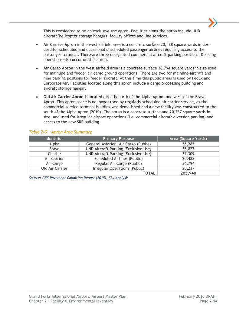
Table 2-6 – Apron Area Summary
Source: GFK Pavement Condition Report (2015), KLJ Analysis
Identifier Primary Purpose Area (Square Yards)
Alpha General Aviation, Air Cargo (Public) 55,285
Bravo UND Aircraft Parking (Exclusive Use) 35,827
Charlie UND Aircraft Parking (Exclusive Use) 37,309
Air Carrier Scheduled Airlines (Public) 20,488
Air Cargo Regular Air Cargo (Public) 36,794
Old Air Carrier Irregular Operations (Public) 20,237
TOTAL 205,940
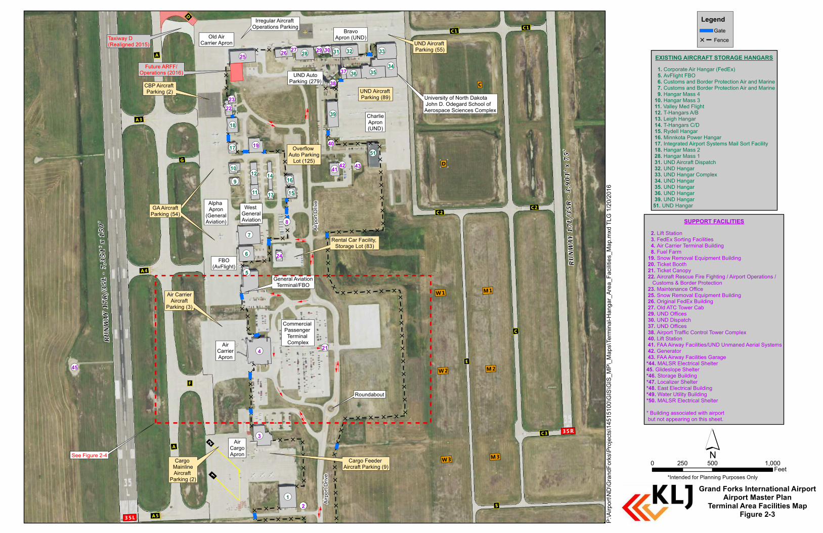
1. Corporate Air Hangar (FedEx) 5. AvFlight FBO 6. Customs and Border Protection Air and Marine 7. Customs and Border Protection Air and Marine 9. Hangar Mass 4 10. Hangar Mass 3 11. Valley Med Flight 12. T-Hangars A/B 13. Leigh Hangar 14. T-Hangars C/D 15. Rydell Hangar 16. Minnkota Power Hangar 17. Integrated Airport Systems Mail Sort Facility 18. Hangar Mass 2 28. Hangar Mass 1 31. UND Aircraft Dispatch 32. UND Hangar 33. UND Hangar Complex 34. UND Hangar 35. UND Hangar 36. UND Hangar 39. UND Hangar51. UND Hangar
[
[[
[
[
[
[
[[
[ [ [
[[
[[
[
[ [
[
[ [ [ [ [
[[
[[
[[
[
[[[[
[
[
[[
[[
[[
[[[
[
[[
[
[ [
[
[[
[
[
[[[
[[
[[
[[
[[
[
[[
[[
[[
[[
[[
[
[
[
[
[
[
[[
[[
[[
[[
[[
[[
[[
[[
[
[
[ [ [ [[
[[
[[
[
[ [ [ [ [
[[
[[
[[
[[
[[
[[[[[
[[
[
[[
[ [
D
A3
A4
A5
F
G
C1 C1
C2
C3
C
E
S
S2
A
A
C2
M3W 3
W 2
W 1
M2
M1
D
C
35R
35L
Airpo
rt Driv
eAir
port D
rive
Alpha Apron
(GeneralAviation)
AirCargoApron
BravoApron (UND)
CharlieApron(UND)
UND AutoParking (279)
Overflow Auto Parking
Lot (125)
West GeneralAviation
FBO(AvFlight)
Old AirCarrier Apron
AirCarrierApron
Commercial Passenger Terminal Complex
University of North Dakota John D. Odegard School of Aerospace Sciences Complex
!(51
UND Aircraft Parking (55)
UND Aircraft Parking (89)
CBP Aircraft Parking (2)
General AviationTerminal/FBO
Rental Car Facility, Storage Lot (83)
GA AircraftParking (54)GA Aircraft
Parking (54)
Air CarrierAircraft
Parking (3)
Cargo MainlineAircraft
Parking (2)
Cargo Feeder Aircraft Parking (9)
Roundabout
See Figure 2-4
Irregular Aircraft Operations Parking
Future ARFF/Operations (2016)
Taxiway D (Realigned 2015)
12
¬«7
¬«1
¬«34
¬«33
¬«35
¬«39
¬«28
¬«6
¬«32
¬«18
¬«36
¬«10
¬«31
¬«15¬«16
¬«5
¬«12
¬«11
¬«14
¬«17
¬«9
¬«13
¬«4
¬«25
¬«3
¬«19
¬«41
¬«26
¬«22
¬«30
¬«37
¬«24
¬«23
¬«29
¬«38
¬«43
¬«8
¬«21
¬«27
¬«40
¬«2
¬«45
¬«42
2. Lift Station 3. FedEx Sorting Facilities 4. Air Carrier Terminal Building 8. Fuel Farm 19. Snow Removal Equipment Building 20. Ticket Booth 21. Ticket Canopy 22. Aircraft Rescue Fire Fighting / Airport Operations / Customs & Border Protection 23. Maintenance Office 25. Snow Removal Equipment Building 26. Original FedEx Building 27. Old ATC Tower Cab 29. UND Offices 30. UND Dispatch 37. UND Offices 38. Airport Traffic Control Tower Complex 40. Lift Station 41. FAA Airway Facilities/UND Unmaned Aerial Systems 42. Generator 43. FAA Airway Facilities Garage*44. MALSR Electrical Shelter45. Glideslope Shelter*46. Storage Building*47. Localizer Shelter*48. East Electrical Building*49. Water Utility Building*50. MALSR Electrical Shelter* Building associated with airport but not appearing on this sheet.
EXISTING AIRCRAFT STORAGE HANGARS
´0 500 1,000250
Feet*Intended for Planning Purposes Only
Grand Forks International AirportAirport Master Plan
Terminal Area Facilities MapFigure 2-3
P:\Air
port\N
D\Gr
andF
orks\P
rojec
ts\14
5151
00\G
IS\GI
S_MP
\_Map
s\Term
inal-H
anga
r_Area
_Fac
ilities
_Map
.mxd
TLG
1/20/2
016
RUNW
AY 1
7L/3
5R -
3,90
1' x
75'
RUNW
AY 1
7R/3
5L -
7,35
1' x
150' SUPPORT FACILITIES
LegendGate
[ Fence

Grand Forks International Airport: Airport Master Plan February 2016 DRAFT Chapter 2 – Facility & Environmental Inventory Page 2-16
PAVEMENT CONDITION
Airport pavements are basic infrastructure components at airports. Airfield pavements need to be
maintained in a safe and operable condition for aircraft operations. Pavement condition is
comprehensively evaluated by the State every three years and measured on a 0 to 100 scale known as
the Pavement Condition Index rating. Pavement evaluation includes runway, taxiway, and apron
pavements. A summary of the latest 2015 PCI rating for the runway and selected other airfield
pavements follows.
Table 2-7 – Pavement Condition Summary
Component Surface Type(s) LCD 2015 PCI Range
Air Cargo Apron PCC 1990-1998 84-93
Alpha Apron PCC, APC 1963-2013 3-96
Bravo Apron - East PCC, APC 1968-2014 21-91
Bravo Apron – West PCC 1966-1986 10-57
Charlie Apron PCC 1987-2003 14-84
Terminal Apron PCC 2010 95
Runway 17L/35R PCC 1983-1988 80-81
Runway 17R/35L APC 2001 74-83
Runway 9L/27R PCC 1992 90-93
Runway 9R/27L PCC 2009 97
Taxiway H (East GA Taxilanes) PCC 1963-2007 7-92
Taxiway A, A1, A2, A3, A4, A5 PCC 1977-2007 72-96
Taxiway B, B1 PCC 1964-2015 12-100
Taxiway C, C1, C2, C3 PCC 1983 76-91
Taxiway D PCC 2015 100
Taxiway E PCC 2009 98
Taxiway F PCC 1998 95
Taxiway G PCC 1989 74
Taxiway S, S1, S2 PCC 2009 95-98
Taxiway U AC 1983-1992 49-83 Source: GFK Pavement Condition Report (2015) PCI = Pavement Condition Index rating (0-100), LCD = Last Major Construction Date, AC = Asphalt Concrete, APC = Asphalt Overlay over PCC, PCC = Portland Cement Concrete
There are still pavement sections in the Alpha Apron, Taxiway B and hangar site taxilanes that date
back to the original airport construction.
Of particular note is primary Runway 17R/35L. This pavement was constructed with a full concrete
section and a 6-inch polymer-modified grooved asphalt overlay was added in 2001. The runway
pavement section is showing major signs of wear on the surface with transverse cracks, longitudinal
cracks, and heaving. In the summer of 2015, the runway pavement heaved in several spots and caused
issues with aircraft operations. The pavement settled after transverse cuts were made into the
pavement. However, long-term solutions may necessitate/warrant the complete reconstruction of the
pavement section sooner than what the current surface PCI would suggest.
Additional pavement information including PCI maps can be found in Appendix X: Airfield Pavement
Condition.
Navigational Aids & Airspace
Navigational aids (NAVAIDs) provide visual and electronic guidance to pilots enabling the airport to
safely, efficiently and effectively accommodate arriving and departing flights. Airspace is a resource

Grand Forks International Airport: Airport Master Plan February 2016 DRAFT Chapter 2 – Facility & Environmental Inventory Page 2-17
that is necessary to allow flights to safely operate and maneuver in the airport environment. Figure 2-
2 identifies visual and electronic navigational aids and weather facilities graphically.
VISUAL NAVIGATION AIDS
Visual aids are installed to provide airport usability during periods of darkness and/or low visibility.
Pavement markings and lighting systems available at GFK are summarized in the following sections.
Identification Lighting
A white-green rotating beacon is a two-sided light used to assist pilots in the
visual identification of a civilian airport. The GFK rotating airport beacon is
located directly east of Hangar Mass 2. It operates sunset to sunrise and during
Instrument Flight Rules (IFR) conditions.
Pavement Edge Lighting
Pavement edge lighting fixtures are installed off the edges of runway and
taxiway pavement to help pilots identify the edge and ends pavement to
facilitate safe operations in darkness and/or low visibility environments. Runway
edge lights are white (bi-directional), except for the final 3,000 feet of runway
where the lights change color to yellow then red to warn pilots of the end of the
runway. The runway end threshold lights (bi-directional) are green viewing down
the runway at the beginning and red viewing at the end of the runway. Taxiway
edge lights are blue and omni-directional.
Runway 17R/35L is equipped with High Intensity Runway Lighting (HIRL). It has
been expressed by the sponsor the HIRL system for Runway 17R/35L is nearing
the end of its useful life. It was noted that replacing the lighting system should be made a priority in
the near future.
Runways 17L/35R and 9L/27R are equipped with Medium Intensity Runway Lighting (MIRL). The MIRL
system on Runway 17L/35R was upgraded to Light-emitting diode (LED) type lighting system in 2015.
There are no known issues with these lighting systems.
Runway 9R/27L is also equipped with Medium Intensity Runway Lighting (MIRL). This runway lighting
system was installed in 2009 when the runway was originally constructed and consists of LED lighting.
No known issues are present with regards to this lighting system.
In general, taxiway lighting can be found on every taxiway on the airfield. The majority of these
taxiway lights are incandescent, while some on the east-side of the airfield are LED. The LED taxiway
lights pertain mostly to the construction efforts of the newly constructed Runway 9R/27L. Taxiways B
(east of C), C, C1, C2, C3, E, S, S1, S2 and U (north of C1) currently have LED lighting installed.
In-Pavement Runway Lighting
There are some in-pavement edge lights on Runway 17R/35L near the Taxiway B/Runway 17R/35L
intersection, and in-pavement lighting for Land and Hold Short (LASHO) operations on Runway 35L. The
LASHO lighting is located on the hold-short line just south of Runway 9L/27R.
Flush mounted in-pavement runway lighting provides enhanced lighting of critical runway areas to
allow runway operations when visibility is below ½ mile. Touchdown Zone Lighting (TDZL) and
Centerline Lighting (CL) are typical for low visibility runways. No GFK runways are equipped with in-
pavement TDZL or CL lighting.
Visual Approach Lighting
Visual approach lighting provides vertical descent guidance to pilots for a runway end. This navigational
aid is used by the pilot to acquire and maintain the correct glide path for landing. The red and white
GFK Airport Beacon

Grand Forks International Airport: Airport Master Plan February 2016 DRAFT Chapter 2 – Facility & Environmental Inventory Page 2-18
lights emitted are interpreted by the pilot to indicate whether they are too high, too low, or on
glidepath. Precision Approach Path Indicator Lights (PAPI) are the current FAA standard equipment
installed for this purpose, however other types of equipment exist.
Runway 17R/35L, 17L/35R and Runway 9L ends are equipped with a four-box Precision Approach Path
Indicator (PAPI-P4L) system installed on the left side of each runway end. Per the FAA Airport Master
Record, each PAPI system is set to the standard 3 degree glidepath angle, while Runway 35L is set to a
more shallow 2.76 degrees.
The Runway 27R end is equipped with a four-box Visual Approach Slope Indicator (VASI-P4L) system
installed on the left side. This provides the same information as a PAPI system but is older technology.
Runway 9R/27L ends are equipped with a two-box Precision Approach Path Indicator (PAPI-P2L) system
installed on the left side of each runway end. Per the FAA Airport 5010 Report, all runway ends are set
to the standard 3 degree angle.
It should be noted the Grand Forks Regional Airport Authority owns PAPIs on Runway 9R, 27L, 17L, 35R,
and 35L. All other VGSI systems are owned and controlled by the FAA (9L, 27R, 17R).
Approach Lighting System
An approach lighting system provides extended runway
centerline alignment information near the runway’s end for
pilots to transition from instrument flight to visual flight for
landing in low visibility conditions. There are several types
of systems with varying configurations.
GFK Runway 35L has an approach lighting system known as
a Medium Approach Lighting System with Runway Alignment
Indicator Lights (MALSR). A MALSR system consists of green
threshold lamps, a set of high-intensity white and red
steady-burning lights located up to 1,400 feet from the runway end, plus a single row of sequenced
flashing lights located another 1,000 feet out. The MALSR system supports the Runway 35L Instrument
Landing System (ILS).
Runway End Identification Lighting
Runway End Identifier Lights (REILs) are a set of synchronized flashing white strobe lights installed on
each side of the runway to provide rapid and positive identification of the approach end of a runway
without complex visual approach lighting. The system can be unidirectional toward the runway
approach or omnidirectional. Unidirectional REILs are installed on Runway 17R and 27R ends and are in
good working condition.
Pilot-Controlled Lighting
Airfield lighting systems allow for pilots to control the complexity and intensity of lights. GFK does not
utilize pilot controlled lighting during control tower operating hours. When the tower is closed
Example MALSR (Typical)
Runway 35L PAPI (P4L)
Grand Forks International Airport: Airport Master Plan February 2016 DRAFT Chapter 2 – Facility & Environmental Inventory Page 2-19
(11:30PM-6:00AM), Pilot controlled lighting on the airfield is utilized. Pilot controlled lighting typically
comes in three intensity levels. By clicking the aircraft microphone button three, five, or seven times,
the pilot controls the intensity of the lighting. This feature is utilized through the airports UNICOM
frequency during non-towered operating hours.
Pavement Markings
Pavement markings provide visual guidance to aircraft to critical
areas on the runway and taxiway surface. Runway markings vary
in complexity depending on the type of approach. GFK Runway
17R/35L has precision instrument approach markings on both
approach ends. Runway 9L/27R has non-precision instrument
approach markings on both approach ends. Runways 17L/35R and
9R/27L have visual approach markings on both approach ends.
Taxiway markings include centerline striping to provide proper
clearance from pavement edges and fixed objects.
Taxiway/taxilane centerline striping is in place at GFK. Each
taxiway/runway intersection contains visually-enhanced
centerline markings approximately 150 feet from the runway
holding position markings to help prevent runway incursions. Some
intersections have taxiway intersection holding position markings.
Runway hold position markings identify the safety setback from active runways in association with
airfield guidance signs. Hold position markings are installed 260 feet from centerline of Runway
17R/35L, and 200 feet from the centerline of Runways 17L/35R, 9L/27R and 9R/27L. Runway Guard
Lights (RGLs) are installed where taxiways cross mid-field portions of Runway 17R/35L and 9L/27R.
Other pavement markings at GFK include aircraft tie-downs, Secure Identification Display Area (SIDA)
security boundaries, aircraft movement area boundary and a VOR calibration arrow. All pavement
markings are compliant with FAR Part 139 for certificated airports.
Airfield Guidance Signs
Guidance signs provide location, direction, and guidance information to pilots on the ground to
enhance awareness. Signs are placed around the airfield to identify runway and taxiway intersections,
runway hold positions and other guidance. Mandatory signs are red and
identify an intersection with a runway or critical safety zone. Other
types of signs include location, direction, destination and distance
remaining signs.
GFK has a full array of airfield guidance signs compliant with FAR Part
139 for certificated airports. Lighted mandatory signs are installed
where taxiways meet all runways. All movement area signage on the
airfield is lighted and reflective.
ELECTRONIC NAVIGATION AIDS
Electronic navigational aids are installed to provide critical guidance information when operating in the
airport environment. These navigational aids often provide horizontal and/or vertical guidance in
conjunction with published navigation procedures. Electronic navigation aids available at GFK are
summarized below:
Very High Frequency Omni-Directional Range (VOR)
This ground-based navigational aid projects an omni-directional signal that allows equipped aircraft to
navigate to and from the station.
“Taxiway G” Directional Sign
GFK Pavement Marking Array

Grand Forks International Airport: Airport Master Plan February 2016 DRAFT Chapter 2 – Facility & Environmental Inventory Page 2-20
The high-altitude Grand Forks (ID: GFK) VOR/DME station,
broadcasting on frequency 114.3 MHz, is located on-airport
approximately 1,300 feet northwest of Runway 17R/35R and 9L/27R
intersection. The facility is owned and operated by the FAA. The
navigational aid provides navigation to the airport and runway ends.
This VOR station is equipped with Distance Measuring Equipment
(DME) providing slant distance information to pilots. The VOR is also
used to support instrument approache procedures at GFK.
Instrument Landing System (ILS)
An Instrument Landing System is installed for a runway end to allow
pilots to capture a horizontal and vertical radio beam to the runway
threshold to assist in landing. Components of an ILS include the glideslope antenna, localizer antenna,
approach lighting system and marker beacons. The glideslope antenna is located alongside the runway
providing vertical guidance, the localizer antenna is installed beyond the opposite runway end
providing horizontal guidance, the approach lighting system provides visual guidance to the runway
end, and the marker beacons provide aural cues for pilots flying the approach.
GFK currently has a Category I ILS system installed for the Runway 35L approach. Approach minimums
are ½ mile visibility and 200-foot cloud ceiling height. Aircraft can use the localizer beam from the
Runway 35L ILS for what is known as a “back-course” instrument approach procedure. While approach
minimums are higher, the ILS equipment is still useful from the 17R approach end.
Global Positioning System (GPS)
GPS is a satellite-based navigation system that allows location to be triangulated from space-based
satellites. Equipped aircraft can navigate between user-defined or FAA waypoints with lateral and
vertical guidance. With ground-based transmitters known as Wide Area Augmentation System (WAAS)
the system can provide accuracy down to a few feet. GPS is widely becoming the preferred aircraft
navigation system and FAA is establishing en-route and approach procedures using this satellite-based
technology. GPS is used at GFK in the establishment of straight-in instrument approach procedures with
horizontal and vertical guidance to the approaches of Runway 17R, 35L, 9L, and 27R.
METEOROLOGICAL FACILITIES
Metrological facilities provide users with up-to-date weather
information at the airport to aid in pilot decision making for safe
flight operations.
Wind Indicator
Wind direction indicators provide immediate visual indication of the
wind direction and velocity. A segmented circle provides a visual
indication of the wind cone area together with runway alignment
and/or traffic pattern information. At GFK, a primary lighted wind
cone is installed near the midpoint of Runway 17R/35L, located 625
feet west of runway centerline. Supplemental wind cones are also
located near each landing threshold.
Weather Reporting
There are two types of weather reporting systems on an airport.
Automated Surface Observation Systems (ASOS) are operated and controlled by the National Weather
Service and FAA. These primary climate stations have equipment that provide weather observations
every minute. A second-tier Automated Weather Observation System (AWOS) have varying sets of
equipment packages to provide local weather observations.
Example Weather Reporting Station
GFK VOR

Grand Forks International Airport: Airport Master Plan February 2016 DRAFT Chapter 2 – Facility & Environmental Inventory Page 2-21
GFK has an ASOS system installed on-airport. The ASOS is located approximately 3,100 feet from
Runway 35L end and 640 feet west of runway centerline. ASOS typically include sensors such as
ceilometer (cloud height), visibility, precipitation, freezing rain, lightning, ambient/dew point,
anemometer (wind direction), and precipitation accumulation. GFK ASOS is owned and operated by the
FAA. Current weather from the ASOS is reported on the Automated Terminal Information Service (ATIS)
frequency of 119.4 MHz.
Other
GFK does not have other weather reporting systems in place such as a Low Level Wind shear Alert
System (LLWAS) to identify changes in wind speed and/or direction near the airfield, Runway Visual
Range (RVR) equipment is installed to report visibility at various points along the runway. GFK has this
equipment installed at the Runway 35L touchdown zone approximately 3,000 feet beyond the runway
end.
METEOROLOGICAL DATA
Local weather conditions are a significant factor in the design and development of airport facilities.
Temperature affects runway length, wind direction and speed affect runway orientation, and visibility
and cloud ceiling conditions affect the need for runway navigational aids and lighting. Over the last 30
years (1981-2010) the average maximum temperature at GFK in the hottest month has been 81.0
degrees Fahrenheit (July).
Prevailing winds are from the north-northwest, generally aligned with the airport’s runway
configuration. Crosswind or tailwind conditions can be hazardous to aircraft operations if they exceed
the operational capabilities of the airplane or flight crew. The smallest aircraft are typically the most
affected operationally by crosswinds.
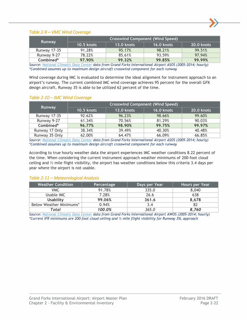
Based on GFK runway design, the maximum crosswind component for Runway 17-35 is 20 knots, and
Runway 9-27 is 13 knots. The current all-weather combined wind coverage of all runways exceeds FAA
minimum recommendations of 95 percent.
Table 2-8 – All-Weather Wind Coverage
Runway Crosswind Component (Wind Speed)
10.5 knots 13.0 knots 16.0 knots 20.0 knots
Runway 17-35 91.40% 95.26% 98.25% 99.52%
Runway 9-27 76.82% 84.36% 92.57% 97.28%
Combined* 97.81% 99.29% 99.84% 99.99% Source: National Climatic Data Center data from Grand Forks International Airport ASOS (2005-2014; hourly) *Combined assumes up to maximum design aircraft crosswind component for each runway
Pilots are able to fly with visual reference to the ground and other aircraft during most weather
conditions. This is known as Visual Meteorological Conditions (VMC). Pilots are required to reference
flight instruments and be on a FAA Instrument Flight Riles (IFR) flight plan when the cloud ceiling is less
than 1,000 feet above the ground or the flight visibility is less than 3 statute miles. These conditions
are known as Instrument Meteorological Conditions (IMC) and require a pilot to be instrument rated.
Wind coverage during VMC is evaluated to determine the ideal alignment for runways used during visual
operations, such as VFR flight training. The current combined VMC wind coverage achieves 95 percent
for the smallest design aircraft (10.5 knot crosswind component).
Grand Forks International Airport: Airport Master Plan February 2016 DRAFT Chapter 2 – Facility & Environmental Inventory Page 2-22
Table 2-9 – VMC Wind Coverage
Runway Crosswind Component (Wind Speed)
10.5 knots 13.0 knots 16.0 knots 20.0 knots
Runway 17-35 91.28% 95.17% 98.21% 99.51%
Runway 9-27 78.22% 85.61% 93.59% 97.94%
Combined* 97.90% 99.32% 99.85% 99.99% Source: National Climatic Data Center data from Grand Forks International Airport ASOS (2005-2014; hourly) *Combined assumes up to maximum design aircraft crosswind component for each runway
Wind coverage during IMC is evaluated to determine the ideal alignment for instrument approach to an
airport’s runway. The current combined IMC wind coverage achieves 95 percent for the overall GFK
design aircraft. Runway 35 is able to be utilized 62 percent of the time.
Table 2-10 – IMC Wind Coverage
Runway Crosswind Component (Wind Speed)
10.5 knots 13.0 knots 16.0 knots 20.0 knots
Runway 17-35 92.62% 96.23% 98.66% 99.60%
Runway 9-27 61.34% 70.56% 81.29% 90.03%
Combined* 96.77% 98.90% 99.75% 99.97%
Runway 17 Only 38.34% 39.49% 40.30% 40.48%
Runway 35 Only 62.00% 64.47% 66.09% 66.85% Source: National Climatic Data Center data from Grand Forks International Airport ASOS (2005-2014; hourly) *Combined assumes up to maximum design aircraft crosswind component for each runway
According to true hourly weather data the airport experiences IMC weather conditions 8.22 percent of
the time. When considering the current instrument approach weather minimums of 200-foot cloud
ceiling and ½ mile flight visibility, the airport has weather conditions below this criteria 3.4 days per
year where the airport is not usable.
Table 2-11 – Meteorological Analysis
Weather Condition Percentage Days per Year Hours per Year
VMC 91.78% 335.0 8,040
Usable IMC 7.28% 26.6 638
Usability 99.06% 361.6 8,678
Below Weather Minimums* 0.94% 3.4 82
Total 100.0% 365.0 8,760 Source: National Climatic Data Center data from Grand Forks International Airport AWOS (2005-2014; hourly) *Current IFR minimums are 200-foot cloud ceiling and ½ mile flight visibility for Runway 35L approach

Grand Forks International Airport: Airport Master Plan February 2016 DRAFT Chapter 2 – Facility & Environmental Inventory Page 2-23
COMMUNICATION FACILITIES
Communication facilities allow aircraft to transmit and receive clearances
to air traffic control to safely and effectively navigate the national airspace
system.
Local Area
GFK is a towered airport and is served by a local Airport Traffic Control
Tower (ATCT). ATCT is responsible for providing clearances to aircraft on
the movement areas of the airport and airspace within five miles. The ATCT
is located on the east side of the airport terminal area near the UND
Aerospace facilities.
Aircraft communicate with ATCT during normal tower operating hours of
6:00 A.M. to 11:30 P.M. under Class D Airspace within about 5 miles of the
airport. Between non-operating hours, aircraft are required to operate with
uncontrolled Class E Airspace and announce their presence periodically.
Grand Forks ATCT can be contacted on frequency 118.4 MHz and Ground
Control on 124.575 MHz.
A recording of weather observations and other pertinant airport information
is available on the Automatic Terminal Information Service (ATIS) frequency
of 119.40 MHz. Communication link to the local Grand Forks Flight Service Station for flight plan and
weather information is available through local Clearance Delivery frequency of 135.725 MHz or through
a Remote Communications Outlet (RCO) frequency.
Terminal Area
The terminal area generally describes the airspace within 40 nautical miles of an airport. GFK utilizes
the Grand Forks Air Force Base for Terminal RADAR (Approach/Departure) control. The Grand Forks
Approach and Departure communication frequency is 118.1 MHz.
En-route, approach and departure surfaces are provided by Minneapolis Air Route Traffic Control
Center (ARTCC) located in Farmington, Minnesota. Various air-ground communication transmitters are
located regionally to facilitate air-ground radio communications. A Remote Communications Air-Ground
(RCAG) station is located southwest of the Runway 9L end and is available on frequency 134.75 MHz.
The local presence of this facility enables aircraft to communicate with ATC at a lower altitude in the
local area.
APPROACH/DEPARTURE PROCEDURES
Aircraft operate under either Visual Flight Rules
(VFR) or Instrument Flight Rules (IFR) depending
on weather conditions and/or operational
standards.
Visual Approach/Departure Procedures
Under VFR, pilots are advised to utilize a
standard rectangular traffic pattern around the
runway to approach or depart an airport.
Standard traffic pattern legs include upwind,
crosswind, downwind, base and final. Departures
are typically straight-out from a departing
runway, a 90 degree crosswind, or 180 degree
downwind. Arrivals typically enter a traffic pattern 45 degrees to a downwind leg for landing. All
procedures are conducted at the direction of the local ATCT.
Standard VFR Airport Traffic Pattern (Source: FAA)
Example RCO/RCAG Antenna

Grand Forks International Airport: Airport Master Plan February 2016 DRAFT Chapter 2 – Facility & Environmental Inventory Page 2-24
In general, most traffic patterns in GFK airspace follow the standard left-hand turn. However, when
operating on Runways 27R, 9R, 17R, or 35R the traffic pattern flow is a non-standard right-hand turn.
This is done to eliminate crossing air traffic between parallel runways, and also to keep traffic away
from airport facilities located in the central-portion of the airfield. The traffic pattern altitude at GFK
is 800 feet above ground level (AGL) for small aircraft and 1,500 feet AGL for large aircraft.
Aircraft arriving and departing GFK are sequenced by local ATCT to and from the traffic pattern. With
the high volume of activity at GFK, standards VFR arrival checkpoints have been established to
facilitate the orderly flow of traffic with UND flight training operations. Standard VFR arrival points are
published in the following exhibit.
GFK ATCT also has Land and Hold Short (LAHSO) operations available for flights landing on Runway 27R
and 35L to allow for shorter landing lengths to facilitate landing operations on a crossing runway.
Unless there are LAHSO restrictions from ATCT, all takeoffs and landings are available for the full
runway length.
Exhibit 2-12 – GFK Local Airport Traffic Patterns
Source: University of North Dakota John D. Odegard School for Aerospace Sciences
35L 35R
17L
17R
27R
27L 9R
9L
VFR Reporting Points
Grand Forks International Airport: Airport Master Plan February 2016 DRAFT Chapter 2 – Facility & Environmental Inventory Page 2-25
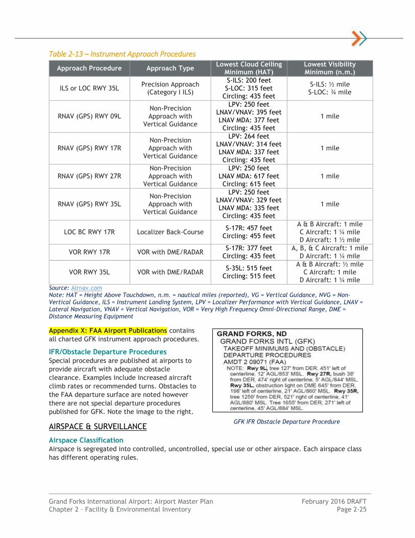
Table 2-13 – Instrument Approach Procedures
Approach Procedure Approach Type Lowest Cloud Ceiling
Minimum (HAT) Lowest Visibility Minimum (n.m.)
ILS or LOC RWY 35L Precision Approach
(Category I ILS)
S-ILS: 200 feet S-LOC: 315 feet
Circling: 435 feet
S-ILS: ½ mile S-LOC: ¾ mile
RNAV (GPS) RWY 09L Non-Precision Approach with
Vertical Guidance
LPV: 250 feet LNAV/VNAV: 395 feet LNAV MDA: 377 feet Circling: 435 feet
1 mile
RNAV (GPS) RWY 17R Non-Precision Approach with
Vertical Guidance
LPV: 264 feet LNAV/VNAV: 314 feet LNAV MDA: 337 feet Circling: 435 feet
1 mile
RNAV (GPS) RWY 27R Non-Precision Approach with
Vertical Guidance
LPV: 250 feet LNAV MDA: 617 feet Circling: 615 feet
1 mile
RNAV (GPS) RWY 35L Non-Precision Approach with
Vertical Guidance
LPV: 250 feet LNAV/VNAV: 329 feet LNAV MDA: 335 feet Circling: 435 feet
1 mile
LOC BC RWY 17R Localizer Back-Course S-17R: 457 feet
Circling: 455 feet
A & B Aircraft: 1 mile C Aircraft: 1 ¼ mile D Aircraft: 1 ½ mile
VOR RWY 17R VOR with DME/RADAR S-17R: 377 feet
Circling: 435 feet A, B, & C Aircraft: 1 mile
D Aircraft: 1 ¼ mile
VOR RWY 35L VOR with DME/RADAR S-35L: 515 feet
Circling: 515 feet
A & B Aircraft: ½ mile C Aircraft: 1 mile
D Aircraft: 1 ¼ mile Source: Airnav.com Note: HAT = Height Above Touchdown, n.m. = nautical miles (reported), VG = Vertical Guidance, NVG = Non-Vertical Guidance, ILS = Instrument Landing System, LPV = Localizer Performance with Vertical Guidance, LNAV = Lateral Navigation, VNAV = Vertical Navigation, VOR = Very High Frequency Omni-Directional Range, DME = Distance Measuring Equipment
Appendix X: FAA Airport Publications contains
all charted GFK instrument approach procedures.
IFR/Obstacle Departure Procedures
Special procedures are published at airports to
provide aircraft with adequate obstacle
clearance. Examples include increased aircraft
climb rates or recommended turns. Obstacles to
the FAA departure surface are noted however
there are not special departure procedures
published for GFK. Note the image to the right.
AIRSPACE & SURVEILLANCE
Airspace Classification
Airspace is segregated into controlled, uncontrolled, special use or other airspace. Each airspace class
has different operating rules.
GFK IFR Obstacle Departure Procedure

Grand Forks International Airport: Airport Master Plan February 2016 DRAFT Chapter 2 – Facility & Environmental Inventory Page 2-26
GFK’s airspace is somewhat complex, as it sits
directly east of the Grand Forks Air Base and its
Military Operations Area (MOA). GFK’s
immediate terminal area airspace is classified
as Class D airspace during ATCT operational
hours. Class D airspace extends from the
surface to 2,500 feet AGL or 3,300 feet MSL
with a radius of 5 nautical miles. When ATCT is
closed the airspace is Class E airspace with a
floor of 700 feet AGL. Class E airspace also
extends north and south to protect airspace of
the instrument approaches. This airspace is
used to transition between the terminal and en-
route environment. Beyond the 5 nautical mile
ring Class E airspace begins at 1,200 feet above
ground level.
All flights must contact ATC before entering
Class D airspace. No ATC clearance or radio
communication is required for VFR flights in
Class E or G airspace, however ATC services are available. For IFR flights, ATC clearance is required
before entering controlled Class E airspace. IFR flights departing GFK must receive an IFR clearance on
the ground. GFK is located approximately 75 miles south of Canadian airspace.
Ground Radar
Radar relies on direct line-of-sight, therefore the further the target is away from a radar site the
higher altitude is required. The Airport Surveillance Radar (ASR) that identifies aircraft in the local
area is located at the Grand Forks Air Force Base located eight miles west of GFK. The ASR provides
primary radar for the airspace around GFK starting a few hundred feet above the ground.
Long-range Air Route Surveillance Radar (ARSR) facilities are owned by the FAA providing primary long-
range radar to identify aircraft. At GFK, the closest United States ARSR is located in Finley, North
Dakota approximately 36 nautical miles from the airport.
Exhibit 2-14 – FAA Airspace Classifications
Source: Federal Aviation Administration (FAA) Pilot’s Handbook of Aeronautical Knowledge (2007)
FAA VFR Sectional Chart (Skyvector.com)
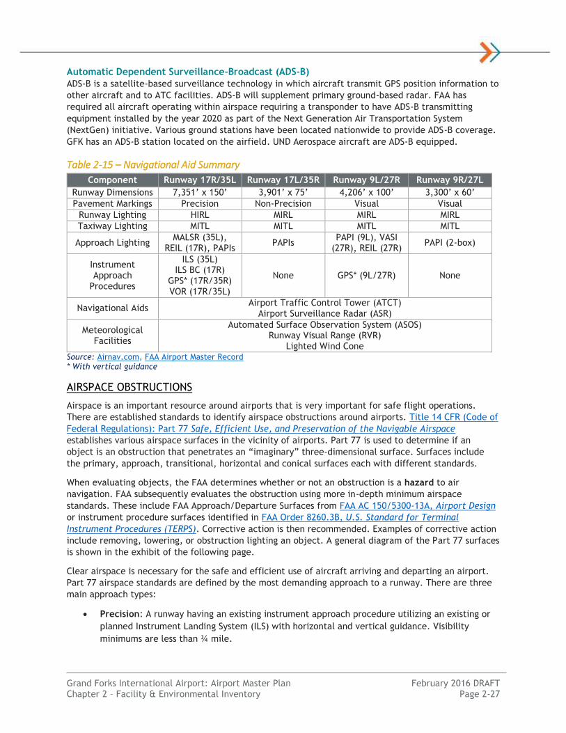
Grand Forks International Airport: Airport Master Plan February 2016 DRAFT Chapter 2 – Facility & Environmental Inventory Page 2-27
Automatic Dependent Surveillance-Broadcast (ADS-B)
ADS-B is a satellite-based surveillance technology in which aircraft transmit GPS position information to
other aircraft and to ATC facilities. ADS-B will supplement primary ground-based radar. FAA has
required all aircraft operating within airspace requiring a transponder to have ADS-B transmitting
equipment installed by the year 2020 as part of the Next Generation Air Transportation System
(NextGen) initiative. Various ground stations have been located nationwide to provide ADS-B coverage.
GFK has an ADS-B station located on the airfield. UND Aerospace aircraft are ADS-B equipped.
Table 2-15 – Navigational Aid Summary
Component Runway 17R/35L Runway 17L/35R Runway 9L/27R Runway 9R/27L
Runway Dimensions 7,351’ x 150’ 3,901’ x 75’ 4,206’ x 100’ 3,300’ x 60’
Pavement Markings Precision Non-Precision Visual Visual
Runway Lighting HIRL MIRL MIRL MIRL
Taxiway Lighting MITL MITL MITL MITL
Approach Lighting MALSR (35L),
REIL (17R), PAPIs PAPIs
PAPI (9L), VASI (27R), REIL (27R)
PAPI (2-box)
Instrument Approach
Procedures
ILS (35L) ILS BC (17R)
GPS* (17R/35R) VOR (17R/35L)
None GPS* (9L/27R) None
Navigational Aids Airport Traffic Control Tower (ATCT)
Airport Surveillance Radar (ASR)
Meteorological Facilities
Automated Surface Observation System (ASOS) Runway Visual Range (RVR)
Lighted Wind Cone Source: Airnav.com, FAA Airport Master Record * With vertical guidance
AIRSPACE OBSTRUCTIONS
Airspace is an important resource around airports that is very important for safe flight operations.
There are established standards to identify airspace obstructions around airports. Title 14 CFR (Code of
Federal Regulations): Part 77 Safe, Efficient Use, and Preservation of the Navigable Airspace
establishes various airspace surfaces in the vicinity of airports. Part 77 is used to determine if an
object is an obstruction that penetrates an “imaginary” three-dimensional surface. Surfaces include
the primary, approach, transitional, horizontal and conical surfaces each with different standards.
When evaluating objects, the FAA determines whether or not an obstruction is a hazard to air
navigation. FAA subsequently evaluates the obstruction using more in-depth minimum airspace
standards. These include FAA Approach/Departure Surfaces from FAA AC 150/5300-13A, Airport Design
or instrument procedure surfaces identified in FAA Order 8260.3B, U.S. Standard for Terminal
Instrument Procedures (TERPS). Corrective action is then recommended. Examples of corrective action
include removing, lowering, or obstruction lighting an object. A general diagram of the Part 77 surfaces
is shown in the exhibit of the following page.
Clear airspace is necessary for the safe and efficient use of aircraft arriving and departing an airport.
Part 77 airspace standards are defined by the most demanding approach to a runway. There are three
main approach types:
Precision: A runway having an existing instrument approach procedure utilizing an existing or
planned Instrument Landing System (ILS) with horizontal and vertical guidance. Visibility
minimums are less than ¾ mile.

Grand Forks International Airport: Airport Master Plan February 2016 DRAFT Chapter 2 – Facility & Environmental Inventory Page 2-28
Non-Precision: A runway having an existing instrument approach procedure utilizing air
navigation facilities with horizontal guidance, or area type navigation equipment, for which a
straight-in non-precision instrument approach procedure has been approved or planned.
Approaches with vertical guidance are considered non-precision. Visibility minimums are
typically 1 mile but as low as ¾ mile.
Visual: A runway intended solely for the operation of aircraft using visual approach procedures,
with no straight-in instrument approach procedure published or planned.
There are two runway classifications:
Utility: A runway that is constructed for and intended to be used by propeller driven aircraft of
12,500 pounds maximum gross weight and less.
Other-Than-Utility: A runway that is constructed for and intended to be used by aircraft
greater than 12,500 pounds maximum gross weight.
The combination of the approach type and the runway classification defines the dimensional criteria
for each approach. The Part 77 airspace dimensional criteria for GFK is identified in the following
table.
Table 2-16 – Existing Part 77 Approach Airspace Standards
Runway End
Approach Standards
Distance From
Runway End
Inner Width*
Outer Width
Length Slope
17R Non-Precision
Other-Than-Utility Greater than ¾ mile
200’ 500’ 3,500’ 10,000’ 34:1
35L Precision
Other-Than-Utility 200’ 1,000’ 16,000’ 50,000’
50:1/ 40:1
17L Visual Utility 200’ 250’ 1,250’ 5,000’ 20:1
35R Visual Utility 200’ 250’ 1,250’ 5,000’ 20:1
9L Non-Precision
Other-Than-Utility Greater than ¾ mile
200’ 500’ 3,500’ 10,000’ 34:1
27R Non-Precision
Other-Than-Utility Greater than ¾ mile
200’ 500’ 3,500’ 10,000’ 34:1
9R Visual Utility 200’ 250’ 1,250’ 5,000’ 20:1
27L Visual Utility 200’ 250’ 1,250’ 5,000’ 20:1 Source: 14 CFR Part 77, FAA Airport Master Record *Inner width is also the Primary Surface width driven by the most demanding approach to a runway.
Based on GFK’s most up-to-date FAA Airport Master Record, there are no critical Part 77 approach
surface obstructions to any runway end at GFK. As a part of the master plan process, a more detailed
obstruction analysis will be completed using data from an Aeronautical Survey. This detailed
obstruction identification and mitigation disposition is identified in the Airport Layout Plan developed
at the end of this planning study located in Appendix X: Airport Layout Plan.

Grand Forks International Airport: Airport Master Plan February 2016 DRAFT Chapter 2 – Facility & Environmental Inventory Page 2-29
Exhibit 2-17 – FAR Part 77 Airspace
Source: Federal Aviation Administration (FAA)

Grand Forks International Airport: Airport Master Plan February 2016 DRAFT Chapter 2 – Facility & Environmental Inventory Page 2-30
SURROUNDING AIRPORTS
Public use airports in the United States with instrument procedures within 50 nautical miles of GFK
were reviewed to provide background into the other area airports.
Table 2-18 – Surrounding Public Airports
Airport Name / City FAA ID Location from GFK
Based Aircraft
Instrument Approach
Longest Runway
Grand Forks Int’l GFK - 147 ILS 7,351’ x 150’
Grand Forks AFB RDR 9 nm 12 ILS 12,351’ x 150’
Northwood Municipal 4V4 22 nm 18 GPS 3,160’ x 60’
Crookston Municipal CKN 23 nm 33 GPS 4,300’ x 75’
Warren Municipal D37 24 nm 6 GPS 3,199’ x 75’
Grafton – Hutson Field GAF 29 nm 29 GPS 4,074’ x 115’
Hillsboro Municipal 3H4 36 nm 22 GPS 3,301’ x 60’
Thief River Falls Regional TVF 41 nm 25 ILS 6,504’ x 150’
Cooperstown Municipal S32 49 nm 13 GPS 3,500’ x 60’
Hallock Municipal HCO 49 nm 12 GPS 4,007’ x 75’ Source: Airnav.com, FAA Airport Master Record
The next closest Part 139 certificated airport with an ILS would be Thief River Falls Regional Airport
(TVF) in Thief River Falls, MN roughly 40 nautical miles northeast of GFK. Another option is Hector
International Airport (FAR) in Fargo, ND roughly 65 nautical miles to the south of GFK with a 9,000-foot
long runway. Both airports are roughly one hour of drive time away from GFK.
Commercial Passenger Terminal
The passenger terminal complex is located along
Airport Drive in the southwest portion of the
terminal area. It is located east of Runway 17L/35R
along Taxiway A at the intersection with Taxiway F.
The terminal complex was constructed in 2010
replacing the existing complex on the northwest
quadrant of the GFK terminal area.
TERMINAL BUILDING
The terminal building serves multiple functions to process passengers and baggage on commercial
airlines. Airlines utilizing the terminal include Allegiant Airlines, Delta Air Lines regional subsidiaries
and occasional charter aircraft. The passenger terminal consists of a terminal building and one
concourse that is approximately 50,000 square feet in size on two levels. There are currently two
aircraft gates each with a passenger loading bridge.
First Floor
First floor functional areas include ticketing lobby, airline offices,
baggage screening, baggage handling, baggage claim, car rental
offices, public waiting/circulation areas and restrooms. There is
approximately 28,000 square feet of total space.
The ticketing lobby is located in the north portion of the terminal
with four ticket counters (8 podium spaces) for processing
passengers and five electronic podiums operated by the airlines.
Airline offices are located behind the ticketing area.
Ticketing Lobby

Grand Forks International Airport: Airport Master Plan February 2016 DRAFT Chapter 2 – Facility & Environmental Inventory Page 2-31
Outbound baggage facilities consist of an in-line baggage handling system (BHS) located behind the
airline ticketing and offices. Baggage is screened by TSA and sorted to carousels to be transported by
baggage cart to aircraft. The baggage handling area to process inbound and outbound bags is
enclosed/heated. This area also has a shipping/receiving area on the south side.
The baggage claim area is located in the south portion of the
terminal buidlling. There is one baggage carrosel with
approximately 110 linear feet claim frontage and a large bag door
for passengers to pick up their arriving luggage. There are three car
rental offices serving Avis, Enterprise, and Hertz. The lower level
also includes a small office, electrical and data rooms, a men’s and
women’s restroom, shipping/receiving area and airline office
space. Escalators, stairs and an elevator provides passenger access
to the second floor. There are three other stairwells in secure
areas.
Second Floor
Second floor functional areas include Transportation Security Administration (TSA) screening/queuing,
gate hold rooms/passenger waiting areas, greeter’s lobby, restrooms, concessions, administration
offices, conference room and TSA offices. There is approximately 21,900 square feet of total space.
The passenger security screening checkpoint is located on the second level adjacent to the exit lane
and greeter lobby. The checkpoint operates around departing flight times. There is currently one
checkpoint lane. Equipment includes a metal detector and an x-ray baggage screener. The checkpoint’s
size and configuration causes the waiting queue to extend into the general circulation area during peak
times. A second lane for TSA Pre-Check passengers is planned.
The gate area provides passenger waiting area for outbound
passengers and circulation for inbound passengers. There are two
gates; Gate 1 located on the north and Gate 2 located on the south
end of the terminal building. Both gates have passenger boarding
bridges that both pivot and extend to accommodate various sized
aircraft. The entire waiting area and circulation corridor is 40 feet
deep causing passenger congestion when two aircraft are loading and
unloading in the peak hour. The second floor also features men’s and
women’s restrooms, and a restaurant/bar/gift shop concessionaire
and miscellaneous storage, mechanical and custodial space.
The following table breaks down the terminal space by function areas
with these spaces depicted graphically in Exhibit 2-20 and 2-21.
Baggage Claim
Gate Waiting Area

Grand Forks International Airport: Airport Master Plan February 2016 DRAFT Chapter 2 – Facility & Environmental Inventory Page 2-32
Table 2-19 – Passenger Terminal Space Breakdown
Space Category Lower Level Area Upper Level Area Total
Airline Offices 1,489 0 1,489
Airport Administration 492 1,601 2,093
Baggage Claim 4,092 0 4,092
Baggage Handling 5,808 0 5,808
Public Space, Restrooms 7,545 11,990 19,535
Rental Car 744 0 744
Concessions 0 1,532 1,532
Security Screening & TSA 1,071 4,178 5,429
Ticketing 5,002 0 5,002
Other 108 678 786
Mech., Equip., Storage 1,713 1,952 3,665
TOTAL 28,064 21,931 49,995 Source: Grand Forks International Airport, KLJ Analysis; Note: Area expressed in Square Feet (SF)
APRON & GATES
The 20,619 square yard air carrier apron is accessed by aircraft
from Taxiway A and F. There are three aircraft parking stands and
a passenger boarding bridge for each gate. A service vehicle
roadway connection is located on the north end. Vehicles travel
within Taxiway Object Free Areas (TOFA).
GFK has a total of two gates. Gate 1 accommodate aircraft as
large as a Boeing 757-200 operated by Allegiant Airlines and
charter operators. Gate 2 accommodates regional jet aircraft such
as the CRJ-200 or CRJ-900. Two of the three parking stands are
accessible through Gate 2. There are no Federal Inspection Services
(FIS) facilities at the GFK terminal.
Gate 1
GFK Passenger Terminal & Apron

Grand Forks International Airport: Airport Master Plan February 2016 DRAFT Chapter 2 – Facility & Environmental Inventory Page 2-33
Exhibit 2-20 – Passenger Terminal First Floor
Source: Grand Forks International Airport
Secure Area
Non-Secure Area
Departing Passenger Flow
Arriving Passenger Flow
Dual Flow
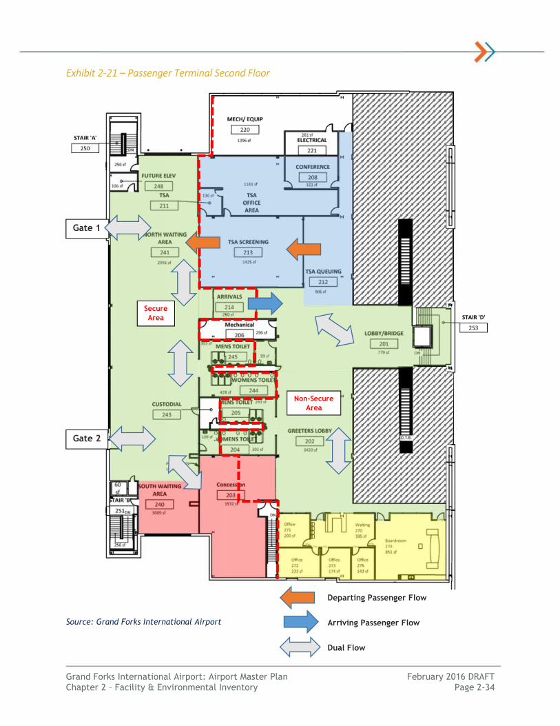
Grand Forks International Airport: Airport Master Plan February 2016 DRAFT Chapter 2 – Facility & Environmental Inventory Page 2-34
Exhibit 2-21 – Passenger Terminal Second Floor
Source: Grand Forks International Airport
Gate 1
Gate 2
Secure Area
Non-Secure Area
Departing Passenger Flow
Arriving Passenger Flow
Dual Flow

Grand Forks International Airport: Airport Master Plan February 2016 DRAFT Chapter 2 – Facility & Environmental Inventory Page 2-35
CIRCULATION & PARKING
The passenger terminal complex is accessed via Airport Road from
signalized intersection with U.S. Highway 2. Airport Road is a two-
lane roadway providing access to the passenger terminal curbside,
rental car and public parking facilities. The passenger terminal
complex is accessible by continuing westbound along an extension
of Airport Drive where a one-way, two to three-lane roadway
provides access to the terminal curbside. The airport exit along
with recirculation access to return to the terminal is accessed via a
roundabout at the exit point, south of the terminal complex.
Figure 2-4: Passenger Terminal Complex depicts these facilities.
The terminal curbside roadway consists of an inner and outer
roadway for the pick-up and drop-off of passengers. The three-lane inner roadway provides
approximately 260 linear feet of curbside with 220 linear feet covered. The roadway features one
curbside parking lane, an overflow/maneuvering lane and a through lane. A separated outer area for
commercial vehicle, shuttle and taxicab staging is available directly west of automobile parking (Lot
A). This area provides a staging lane and a maneuvering lane. Two pedestrian crosswalks provide access
across the curbside connecting the parking lots with the terminal building.
Automobile parking facilities include public, employee and rental car parking lots. All parking facilities
are located within the terminal complex. Public parking is available directly to the east of the terminal
building (Lots A and B). An economy parking (Lot C) lot constructed in 2014 is located across Airport
Drive to meet parking demands during peak months. Passengers walk up to 1,150 feet from the far end
of the economy lot to the terminal building entrance.
Table 2-22 – Terminal Parking Facilities
Group Parking Lot Use/Name Spaces
Public Public Pay Parking (Lot A) 203
Public Public Pay Parking (Lot B) 512
Public Economy Pay Parking (Lot C) 247
Total Public 962
Employee Employee Parking (Lot E) 50
Employee Parking Booth Staff 4
Total Employee 54
Rental Car Ready/Return 88
Rental Car Storage 83
Total Rental Car 171
Grand Total 1,187 Source: Grand Forks International Airport
The airport also has a 125-stall overflow lot located east of the old ARFF/Operations facilities and
sometimes shuttles commercial passengers to and from this lot when high-volumes of vehicle traffic
are anticipated. However, due to the construction of the east economy lot, this now occurs on a less
frequent basis. Based on recent overnight vehicle counts, peak public automobile parking in the
terminal complex occurs in late December, late February early March 2015 with over 700 peak
overnight parkers.
GFK Terminal Curbside

Lot AParking
(203 spaces)Lot B
Parking (512 spaces)
Lot C EconomyParking
(247 spaces)
Lot EEmployeeParking
(50 spaces)Deicing
Area
Air Carrier Apron
Air Carrier Terminal
Rental Car Ready/Return
Parking (88 spaces)
Air Cargo Complex
Gate 1
Gate 2
2B
2A
1
OverflowParking Lot
(125 Spaces;1/4 mile)
Rental Car Facility & Storage Lot (83 Spaces)
FBO (AvFlight)
Terminal Curbside (260 feet)
Outer CommercialVehicle Lanes (2)
Inner Pick-Up/Drop-Off
Lanes (3)
See Exhibit 2-20 and 2-21 for Interior Layouts
Airpo
rt Driv
e U.S. Highway 2(1/2 mile)
´ Grand Forks International AirportAirport Master Plan
Passenger Terminal ComplexFigure 2-4
*Intended for Planning Purposes Only
P:\Air
port\N
D\Gr
andF
orks\P
rojec
ts\14
5151
00\G
IS\GI
S_MP
\_Map
s\Pas
seng
er_Te
rmina
l_Com
plex.m
xd TL
G 2/1
6/201
6
0 250 500125Feet
Legend Vehicle Traffic Flow

Grand Forks International Airport: Airport Master Plan February 2016 DRAFT Chapter 2 – Facility & Environmental Inventory Page 2-37
Rental car facilities consist of the ready/return parking lot located south of the terminal building
leased to each of the rental car concessionaires Hertz, Avis and Enterprise/National. The consortium of
rental car agencies at GFK (known as Autocore) jointly operate a consolidated rental car facility that
was constructed in 2010. This facility features a 4,000 square foot building with three service bays, a
car wash bay, and an adjacent 83-stall concrete parking lot. The building is located north of the
terminal complex along Airport Drive.
Air Cargo
GFK air cargo facilities are primarily located on the southwest
corner of the terminal area along Air Cargo Drive. FedEx
operates out of this complex south of the passenger terminal.
Additional air cargo facilities are located along the Alpha
Apron. FedEx mainline aircraft, feeder aircraft and other
carriers serve also serve the air cargo needs at GFK. See Figure
2-3: Terminal Area Facilities Map.
FedEx air cargo processing activities are performed in a
dedicated 20,700 square foot building located along the north
edge of the Air Cargo Apron along Airport Drive. The processing
facility has landside and airside access, but semi-trucks drive
onto the apron to access the facility and load/unload trailers.
The building contains approximately space for offices and processing packages. FedEx recently added a
third bay in 2014 that allows an additional semi to load/unload packages. FedEx also operates a
maintenance and ground service equipment storage building to the north, off of the Bravo Apron.
During normal operations, FedEx aircraft deliver cargo to/from its U.S. hub in Memphis, Tennessee.
These larger mainline aircraft are loaded and unloaded on the Air Cargo Apron. Packages are sorted
and disbursed to “feeder aircraft”, many of which are operated by Corporate Air. Sorting also occurs in
the adjacent cargo processing building to transfer to ground vehicles. Some ground vehicle operations
travel between the air cargo apron and the Alpha apron which leads to inefficiency and safety concerns
within the air operations area.
Other cargo air mail (USPS) is also removed from larger FedEx aircraft and sent to Consolidated Airline
Service (CAS) facility along the Alpha Apron for sorting and processing. Air mail is sent to Bismarck, ND
for distribution and processing. Likewise, CAS processes incoming mail and brings it to the FedEx Air
Cargo Apron Space.
The 20,619 square yard Air Cargo Apron provides aircraft parking for two (2) larger mainline aircraft
and nine (9) smaller feeder aircraft. The Air Cargo Apron area is a SIDA area with an elevated level of
security. More than one mainline aircraft would block access to the feeder aircraft apron. A 23,625
square foot aircraft storage hangar is adjacent to the south side of the air cargo apron for feeder
aircraft.
FedEx announced in February 2016 it will vacate its leased space at GFK to move its air operations from
GFK to Fargo’s Hector International Airport.
General Aviation
General Aviation (GA) elements include facilities that serve aeronautical needs of the flying public
beyond those needed for commercial airlines. Facilities include those necessary for the movement of
passengers as well as parking, service and storage of aircraft. Examples of these facilities include the
aircraft storage hangars, aircraft parking apron, GA terminal and fixed based operators (FBO).
GFK FedEx Facility
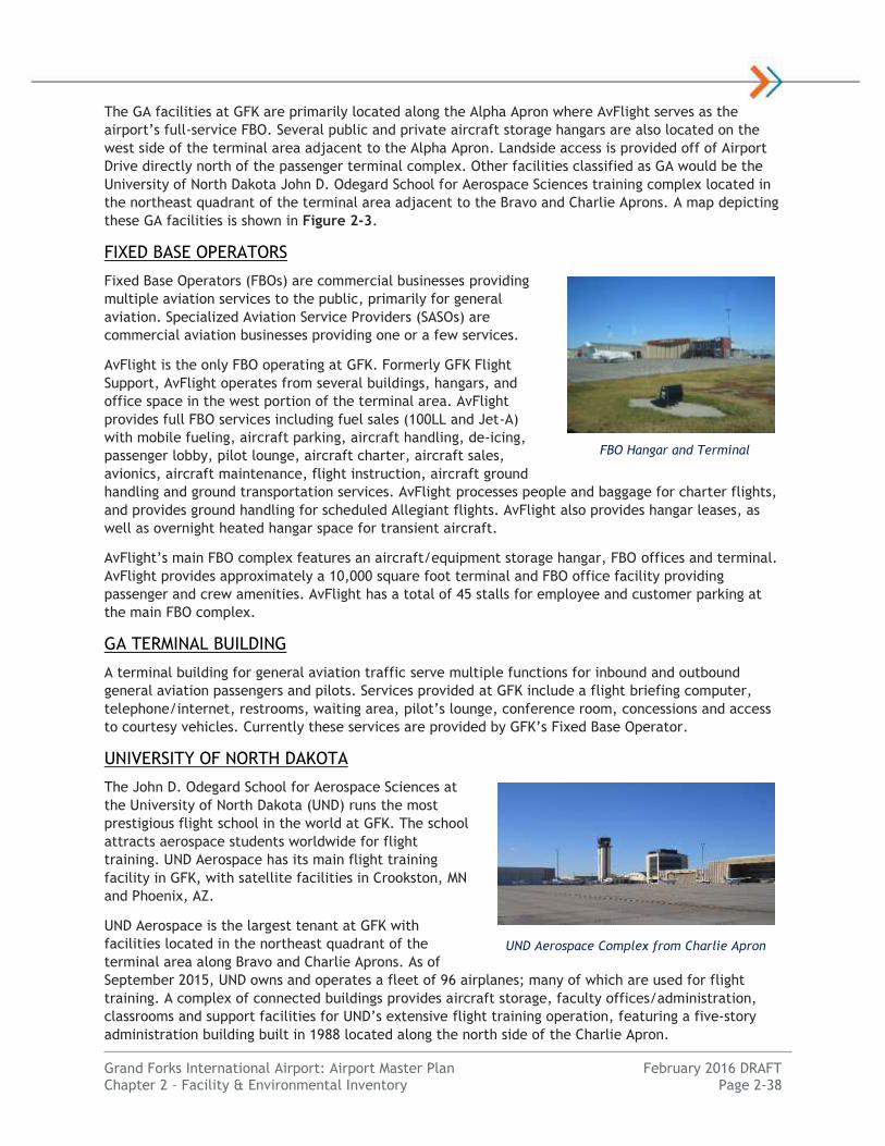
Grand Forks International Airport: Airport Master Plan February 2016 DRAFT Chapter 2 – Facility & Environmental Inventory Page 2-38
The GA facilities at GFK are primarily located along the Alpha Apron where AvFlight serves as the
airport’s full-service FBO. Several public and private aircraft storage hangars are also located on the
west side of the terminal area adjacent to the Alpha Apron. Landside access is provided off of Airport
Drive directly north of the passenger terminal complex. Other facilities classified as GA would be the
University of North Dakota John D. Odegard School for Aerospace Sciences training complex located in
the northeast quadrant of the terminal area adjacent to the Bravo and Charlie Aprons. A map depicting
these GA facilities is shown in Figure 2-3.
FIXED BASE OPERATORS
Fixed Base Operators (FBOs) are commercial businesses providing
multiple aviation services to the public, primarily for general
aviation. Specialized Aviation Service Providers (SASOs) are
commercial aviation businesses providing one or a few services.
AvFlight is the only FBO operating at GFK. Formerly GFK Flight
Support, AvFlight operates from several buildings, hangars, and
office space in the west portion of the terminal area. AvFlight
provides full FBO services including fuel sales (100LL and Jet-A)
with mobile fueling, aircraft parking, aircraft handling, de-icing,
passenger lobby, pilot lounge, aircraft charter, aircraft sales,
avionics, aircraft maintenance, flight instruction, aircraft ground
handling and ground transportation services. AvFlight processes people and baggage for charter flights,
and provides ground handling for scheduled Allegiant flights. AvFlight also provides hangar leases, as
well as overnight heated hangar space for transient aircraft.
AvFlight’s main FBO complex features an aircraft/equipment storage hangar, FBO offices and terminal.
AvFlight provides approximately a 10,000 square foot terminal and FBO office facility providing
passenger and crew amenities. AvFlight has a total of 45 stalls for employee and customer parking at
the main FBO complex.
GA TERMINAL BUILDING
A terminal building for general aviation traffic serve multiple functions for inbound and outbound
general aviation passengers and pilots. Services provided at GFK include a flight briefing computer,
telephone/internet, restrooms, waiting area, pilot’s lounge, conference room, concessions and access
to courtesy vehicles. Currently these services are provided by GFK’s Fixed Base Operator.
UNIVERSITY OF NORTH DAKOTA
The John D. Odegard School for Aerospace Sciences at
the University of North Dakota (UND) runs the most
prestigious flight school in the world at GFK. The school
attracts aerospace students worldwide for flight
training. UND Aerospace has its main flight training
facility in GFK, with satellite facilities in Crookston, MN
and Phoenix, AZ.
UND Aerospace is the largest tenant at GFK with
facilities located in the northeast quadrant of the
terminal area along Bravo and Charlie Aprons. As of
September 2015, UND owns and operates a fleet of 96 airplanes; many of which are used for flight
training. A complex of connected buildings provides aircraft storage, faculty offices/administration,
classrooms and support facilities for UND’s extensive flight training operation, featuring a five-story
administration building built in 1988 located along the north side of the Charlie Apron.
FBO Hangar and Terminal
UND Aerospace Complex from Charlie Apron
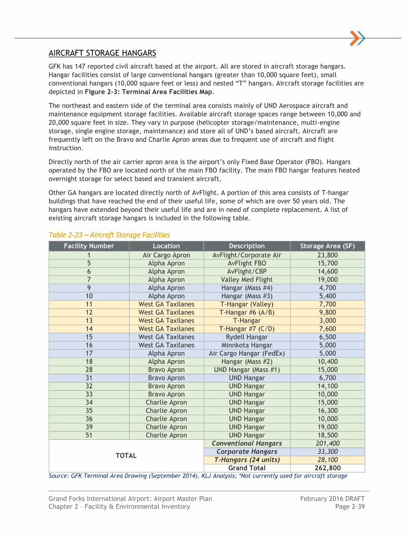
Grand Forks International Airport: Airport Master Plan February 2016 DRAFT Chapter 2 – Facility & Environmental Inventory Page 2-39
AIRCRAFT STORAGE HANGARS
GFK has 147 reported civil aircraft based at the airport. All are stored in aircraft storage hangars.
Hangar facilities consist of large conventional hangars (greater than 10,000 square feet), small
conventional hangars (10,000 square feet or less) and nested “T” hangars. Aircraft storage facilities are
depicted in Figure 2-3: Terminal Area Facilities Map.
The northeast and eastern side of the terminal area consists mainly of UND Aerospace aircraft and
maintenance equipment storage facilities. Available aircraft storage spaces range between 10,000 and
20,000 square feet in size. They vary in purpose (helicopter storage/maintenance, multi-engine
storage, single engine storage, maintenance) and store all of UND’s based aircraft. Aircraft are
frequently left on the Bravo and Charlie Apron areas due to frequent use of aircraft and flight
instruction.
Directly north of the air carrier apron area is the airport’s only Fixed Base Operator (FBO). Hangars
operated by the FBO are located north of the main FBO facility. The main FBO hangar features heated
overnight storage for select based and transient aircraft.
Other GA hangars are located directly north of AvFlight. A portion of this area consists of T-hangar
buildings that have reached the end of their useful life, some of which are over 50 years old. The
hangars have extended beyond their useful life and are in need of complete replacement. A list of
existing aircraft storage hangars is included in the following table.
Table 2-23 – Aircraft Storage Facilities
Facility Number Location Description Storage Area (SF)
1 Air Cargo Apron AvFlight/Corporate Air 23,800
5 Alpha Apron AvFlight FBO 15,700
6 Alpha Apron AvFlight/CBP 14,600
7 Alpha Apron Valley Med Flight 19,000
9 Alpha Apron Hangar (Mass #4) 4,700
10 Alpha Apron Hangar (Mass #3) 5,400
11 West GA Taxilanes T-Hangar (Valley) 7,700
12 West GA Taxilanes T-Hangar #6 (A/B) 9,800
13 West GA Taxilanes T-Hangar 3,000
14 West GA Taxilanes T-Hangar #7 (C/D) 7,600
15 West GA Taxilanes Rydell Hangar 6,500
16 West GA Taxilanes Minnkota Hangar 5,000
17 Alpha Apron Air Cargo Hangar (FedEx) 5,000
18 Alpha Apron Hangar (Mass #2) 10,400
28 Bravo Apron UND Hangar (Mass #1) 15,000
31 Bravo Apron UND Hangar 6,700
32 Bravo Apron UND Hangar 14,100
33 Bravo Apron UND Hangar 10,000
34 Charlie Apron UND Hangar 15,000
35 Charlie Apron UND Hangar 16,300
36 Charlie Apron UND Hangar 10,000
39 Charlie Apron UND Hangar 19,000
51 Charlie Apron UND Hangar 18,500
TOTAL
Conventional Hangars 201,400
Corporate Hangars 33,300
T-Hangars (24 units) 28,100
Grand Total 262,800 Source: GFK Terminal Area Drawing (September 2014), KLJ Analysis; *Not currently used for aircraft storage

Grand Forks International Airport: Airport Master Plan February 2016 DRAFT Chapter 2 – Facility & Environmental Inventory Page 2-40
Support Facilities
Support facilities are necessary to facilitate the day-to-day maintenance and operation of the airport.
A map depicting these facilities is shown in Figure 2-3: Terminal Area Facilities Map.
AIRPORT ADMINISTRATION
Airport Authority administration space is located on the second floor of the passenger terminal
building. This nearly 2,000 square foot area contains office space, reception/waiting area, and a
boardroom/conference room. There are four (4) airport administration offices. There is waiting area
space dedicated for guests, an administrative assistant area and space to store files. The board room is
used for public meetings, interviews, and airport personnel meetings and is approximately 850 square
feet in size. Additional administration space for operations staff is located in the Snow Removal
Equipment (SRE) building and Aircraft Rescue and Fire Fighting (ARFF) complex.
AIRCRAFT RESCUE AND FIRE FIGHTING (ARFF)
ARFF coverage is provided by Airport Authority staff. Old ARFF facilities are located on the north
portion of the Alpha Apron and jointly house ARFF, Operations and Customs and Border Protection
(CBP). This ARFF/Operations building has room for two (2) crash fire rescue trucks, one (1) ambulance
and one (1) airport operations vehicle. It also has two sleeping quarters as ARFF/Operations staff are
on-site 24 hours a day and 7 days per week. The existing ARFF/Operations portion of the building is
nearly 5,300 square feet in size and is over 40 years old.
As of 2016, the airport is completed a major
construction project that relocated ARFF and Operations
to a location directly north of the existing structure.
This new ARFF/Operations complex was constructed to
replace the existing structure that is dated, undersized
and has operational inefficiencies. The new 14,000
square foot facility is larger and has space dedicated to
incident command. The tentative plan is to maintain the
old facility for Customs and Border Protection until a
permanent solution can be made. These facilities are
identified in Figure 2-2.
AIRPORT MAINTENANCE
Airport maintenance is conducted by Airport Authority
staff. Airport maintenance consists of pavement,
painting, lighting, building, snow removal, grass cutting,
and other miscellaneous items required to keep the
airport functional and operational at all hours of the day.
Like the ARFF building, the 13,000 square foot equipment
and maintenance building was old and undersized to
house all of the airport’s Snow Removal Equipment (SRE).
In 2014, the airport constructed and opened a new
21,800 square foot SRE building directly east of the old air carrier apron area in the northwest corner
of the terminal area. The new facility is larger and can hold all of the airport’s Snow Removal
Equipment with 15 equipment bays, driving lane, shop, sand and de-icing fluid storage area. The old
maintenance building is still in use by the airport for storage of airport parts and materials. It also
houses one of the airport’s electrical vaults and generators associated with the entire west side of the
airport.
New ARFF/Operations Complex
New SRE Building Interior

Grand Forks International Airport: Airport Master Plan February 2016 DRAFT Chapter 2 – Facility & Environmental Inventory Page 2-41
GFK owns a total of 26 pieces of mobile equipment and attachments for ARFF coverage, snow removal,
de-icing, grass cutting and airport operations. For snow removal the airport owns 15 pieces of
equipment including three blowers, two brooms, two plows, two blades, two plow/sanders, two
loaders a sweeper and a sand truck.
FUELING FACILITIES
GFK features an airport-owned fuel farm located in the middle of the terminal area on the west side of
Airport Drive. The fuel farm includes above-ground fuel tanks and pumps capable of providing service
on both the landside and the airside portions of the airport. The fuel farm has a total of eight (8) fuel
storage tanks including three (3) AVGAS 100LL, three (3) Jet-A, one (1) Auto, and one (1) diesel.
Table 2-24 – Fuel Storage Facilities
Tank # Fuel Type Capacity (Gal.)
1 100LL AVGAS 20,000
2 100LL AVGAS 20,000
3 100LL AVGAS 20,000
4N JET-A 20,000
4C JET-A 20,000
4S JET-A 20,000
7 Auto Gas (87 Octane) 12,000
8 Diesel 12,000
Total AVGAS 60,000
Total JET-A 60,000 Source: Grand Forks International Airport
The landside portion provides access to fill the tanks and four (4) pumps to dispense automobile fuel
for public and rental car vendor use. This area has a drive-through loop to permit large fuel trucks
access without having to turn around or back into a spot.
Currently, the airport does not have self-service fueling for aircraft operations. Fueling operations are
conducted via fuel trucks on the airside. Fuel trucks are owned and operated by AvFlight (FBO) and
respond to general aviation fuel requests and commercial/cargo aircraft fueling needs. UND Aerospace
conducts their own fueling operations of their aircraft via UND-owned fuel trucks.
FENCING & SECURITY
GFK has an existing security fence network that surrounds the entirety of the airport. Multiple manual
gates are located around the perimeter of the airport. Several electric controlled-access gates are
located between airside/landside facilities on the interior of the airport. These gates allow authorized
individuals to swipe badges to gain entry to the airside portion of the airport. The fence is 10 feet high.
Security is established and maintained per TSA Part 1542 regulations. Airport staff and tenants
requiring access to the sterile side of the terminal/apron area are required to wear and display airport
badging on the outermost portion of all garments at all times. When operating on the apron/sterile side
of the terminal, badging requirements are known as Security Identification Display Areas (SIDA). The
SIDA area is denoted by red lines on terminal and air cargo apron pavement. There are various secure
access points around the terminal complex.
CUSTOMS & IMMIGRATION
GFK has United States Customs and Border Protection (CBP) facilities and staff located on-site. The CBP
facility is located along the Alpha Apron with two (2) aircraft parking positions. There is approximately
1,700 square feet of CBP office and processing space to processes international air traffic coming from
Canada.

Grand Forks International Airport: Airport Master Plan February 2016 DRAFT Chapter 2 – Facility & Environmental Inventory Page 2-42
CBP staff consists of two officers with regular normal hours of operation during the week. Outside of
normal staffing hours, CBP staff is available and on-call for irregular operations or non-scheduled
flights needing customs clearance. However, due to staff size and building size, CBP at GFK is limited
to processing 10 passengers per flight before additional staff would be required. Because of GFK’s
proximity to the Canadian border, there are also CBP staff in Pembina, ND (80 miles north) that
occasionally will travel to GFK for assistance as well.
DEICING FACILITIES
Deicing at GFK is conducted in various locations depending on the type of operation. Commercial
passenger aircraft are pushed back from their gate and staged on the western portion of the air carrier
apron area for de-icing operations. There is no separate holding location for aircraft deicing
operations. The de-icing aircraft location can cause logistical issues with maneuvering other aircraft in
the air carrier apron. There is no deicing containment system.
Air cargo deicing operations are conducted on the air cargo apron at aircraft parking locations. Aircraft
are also deiced on the south portion of Alpha Apron near the FBO. The University of North Dakota does
not practice deicing operations. Occasionally, aircraft will be brought into a hangar to allow the
aircraft time to thaw/remove frost.
Ground Access, Circulation & Parking
These facilities provide vital connectivity within the airport facility and from the airport to the
surrounding community. Facilities are depicted in Figures 2-3 and 2-4.
GROUND ACCESS & CIRCULATION
Public access for the airport is provided by an east/west U.S. Highway 2 (Gateway Drive). A signalized
intersection at Airport Drive provides the public with access to all GFK terminal area facilities. The
airfield is laid out to allow the separation of airside and landside vehicular traffic. Signs guide vehicles
to each facility (FedEx, Air Carrier Terminal, AvFlight, UND, etc.) and automobile parking is located at
each facility. Airport Drive is located within airport property.
There is currently a proposal to modify the traffic control at U.S. Highway 2 and Airport Drive/County
Road 5 intersection. This intersection has been identified by the North Dakota Department of
Transportation as one of the most crash prone rural intersections in the state. One option being
proposed in the U.S. Highway 2 Access Study is to realign Airport Drive approximately 1,000 feet to the
east in a “staggered T-intersection configuration” to remove the signalized intersection and increase
safety.
Access to airside facilities on the airfield is restricted to airport personnel only, and fenced off with
locked or controlled-access gates. Gravel roads around the airport perimeter fence allow access to the
airport perimeter. Currently, the airport does not have a dedicated perimeter road around airfield
pavements for airfield inspections or access to on-airport facilities. Vehicles currently circulate on the
runway, taxiway and apron pavements. Airside gravel roads provide access to individual facilities on
the airfield, such as navigational aids. The first 300 feet of each road is paved from runways and
taxiways.
AUTOMOBILE PARKING
There are a total of 1,978 documented parking spaces at GFK for airport tenants and users. Automobile
parking is located near each respective facility on the airfield. Parking related to the commercial
passenger terminal is discussed previously in this chapter. A total of 1,315 parking spaces are dedicated
for passenger, employee and rental car use. Facilities are depicted in Figures 2-3 and 2-4.
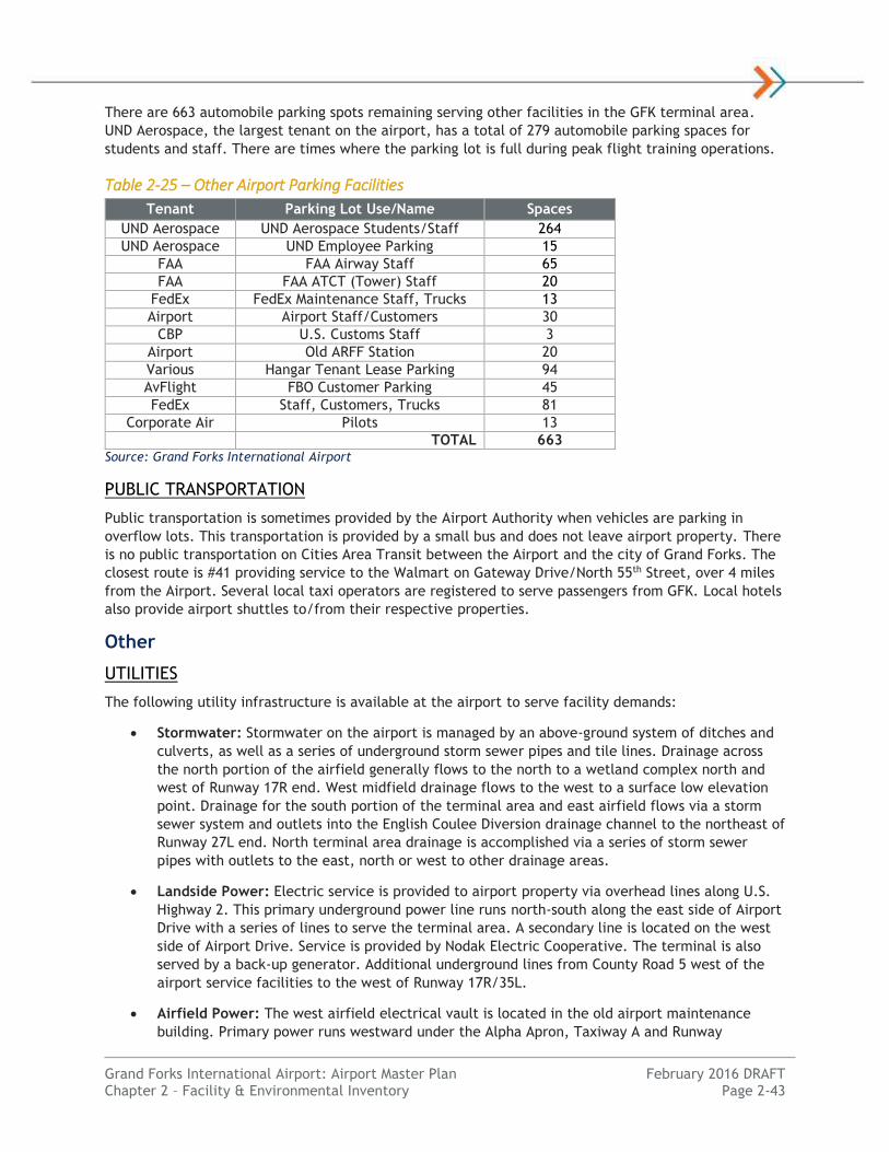
Grand Forks International Airport: Airport Master Plan February 2016 DRAFT Chapter 2 – Facility & Environmental Inventory Page 2-43
There are 663 automobile parking spots remaining serving other facilities in the GFK terminal area.
UND Aerospace, the largest tenant on the airport, has a total of 279 automobile parking spaces for
students and staff. There are times where the parking lot is full during peak flight training operations.
Table 2-25 – Other Airport Parking Facilities
Tenant Parking Lot Use/Name Spaces
UND Aerospace UND Aerospace Students/Staff 264
UND Aerospace UND Employee Parking 15
FAA FAA Airway Staff 65
FAA FAA ATCT (Tower) Staff 20
FedEx FedEx Maintenance Staff, Trucks 13
Airport Airport Staff/Customers 30
CBP U.S. Customs Staff 3
Airport Old ARFF Station 20
Various Hangar Tenant Lease Parking 94
AvFlight FBO Customer Parking 45
FedEx Staff, Customers, Trucks 81
Corporate Air Pilots 13
TOTAL 663 Source: Grand Forks International Airport
PUBLIC TRANSPORTATION
Public transportation is sometimes provided by the Airport Authority when vehicles are parking in
overflow lots. This transportation is provided by a small bus and does not leave airport property. There
is no public transportation on Cities Area Transit between the Airport and the city of Grand Forks. The
closest route is #41 providing service to the Walmart on Gateway Drive/North 55th Street, over 4 miles
from the Airport. Several local taxi operators are registered to serve passengers from GFK. Local hotels
also provide airport shuttles to/from their respective properties.
Other
UTILITIES
The following utility infrastructure is available at the airport to serve facility demands:
Stormwater: Stormwater on the airport is managed by an above-ground system of ditches and
culverts, as well as a series of underground storm sewer pipes and tile lines. Drainage across
the north portion of the airfield generally flows to the north to a wetland complex north and
west of Runway 17R end. West midfield drainage flows to the west to a surface low elevation
point. Drainage for the south portion of the terminal area and east airfield flows via a storm
sewer system and outlets into the English Coulee Diversion drainage channel to the northeast of
Runway 27L end. North terminal area drainage is accomplished via a series of storm sewer
pipes with outlets to the east, north or west to other drainage areas.
Landside Power: Electric service is provided to airport property via overhead lines along U.S.
Highway 2. This primary underground power line runs north-south along the east side of Airport
Drive with a series of lines to serve the terminal area. A secondary line is located on the west
side of Airport Drive. Service is provided by Nodak Electric Cooperative. The terminal is also
served by a back-up generator. Additional underground lines from County Road 5 west of the
airport service facilities to the west of Runway 17R/35L.
Airfield Power: The west airfield electrical vault is located in the old airport maintenance
building. Primary power runs westward under the Alpha Apron, Taxiway A and Runway

Grand Forks International Airport: Airport Master Plan February 2016 DRAFT Chapter 2 – Facility & Environmental Inventory Page 2-44
17R/35L. The east airfield electrical vault is located in a remote building 500 feet east of
Runway 35R. Power is provided by an east-west line from the Air Cargo area to the east
airfield.
Water: Water is sourced from an on-airport well station in the Grand Forks Water Area #38.
The pump house is located at the northeast corner of U.S. Highway 2 and Airport Drive. The
water main line runs north-south along the east side of Airport Drive. Public and private feeder
lines provide service to all airport facilities in the terminal area. Service is provided by the city
of Grand Forks.
Sanitary: Sanitary sewer utilities are provided by the city of Grand Forks. Sanitary lines are
located throughout the airport serving each functional area. Older T-hangars in the west
general aviation area are not served by sanitary sewer. Two wastewater lift stations (#34, #35)
provide flow from lower to higher elevations. Sanitary force main lines exit the airport to the
east from the Air Cargo area to east of Runway 17L/35R.
Telecommunications: Telecommunications lines (telephone, cable television and internet)
service runs from the intersection of U.S. Highway 2 and Airport Drive north-south along Airport
Drive to serve the terminal area. Feeder lines provide service to the Air Cargo, Passenger
Terminal, FBO, Airport Operations and UND Flight Training complex. Service in Grand Forks is
provided by multiple providers.
Natural Gas: Natural gas service is provided with a connection at the northwest corner of U.S.
Highway 2 and Airport Drive. The primary natural gas line runs north-south along the west side
of Airport Drive to service Air Cargo, Passenger Terminal, FBO, Airport Operations and UND
Flight Training complex on both sides of the terminal complex. Service is provided by Nodak
Electric Cooperative.
Heating & Cooling: Heating and cooling of the passenger terminal is accomplished through a
geothermal system. Due to the high water table, 30-40 foot deep geothermal lines were dug
horizontally to a point east of Airport Drive. Other public buildings are heated by natural gas
heaters and cooled through electric-powered air conditioning units.
Other: An underground fuel line runs east-west through airport property to serve the Grand
Forks Air Force Base. This fuel line has an existing 20-foot easement. An unused on-airport
underground fuel line runs from the fuel farm to the old ARFF station.
Surrounding Land Use
Background
The effect of airport planning decisions extends well beyond the airport property boundary. The land
uses that surround the airport must be evaluated to help determine the impact of airport planning
decisions.
Compatible land uses are defined as those uses that can coexist with a nearby airport without either
constraining the safe and efficient operation of the airport or exposing people working or living nearby
to unacceptable levels of noise or safety hazards. Typical airport land use compatibility elements for
airports include:
FAA airspace standards for airport safety and operational capability.
FAA land use compatibility near runway ends associated with the Runway Protection Zone (RPZ)
for the safety of people and property on the ground.
State or local airport land use standards, if applicable.
Grand Forks International Airport: Airport Master Plan February 2016 DRAFT Chapter 2 – Facility & Environmental Inventory Page 2-45
FAA wildlife hazard mitigation plans for aircraft operational safety.
FAA land use compatibility within designated day-night average sound level (DNL) noise
exposure contours to avoid significant impacts to activities on the ground.
This section provides an overview of existing land uses and plans. Surrounding land uses are depicted
graphically in Figure 2-5: Land Use Map.
Existing Land Uses
Although GFK itself is within the Grand Forks city limits, airport property is located approximately 2
miles to the west of the core contiguous Grand Forks city limit boundary. Airport property is within
portions of Sections 21, 28, 33, 4, 34, 35, and 27 of Rye Township in Grand Forks County.
Surrounding existing land uses include primarily open prairie and agricultural production. There are
scattered rural residential and commercial properties to the west of the airport. To the east along
Gateway Drive lies commercial/industrial properties including an auto parts salvage yard.
There are no non-aeronautical structures within any of the existing FAA Runway Protection Zones
(RPZs) to the runway ends as they exist today. U.S. Highway 2, a four-lane divided highway, traverses
within the RPZ for Runway 35L approximately 2,150 feet from the runway end. North 83rd Street, a
public gravel road, is located 750 feet from the Runway 27L end within the RPZ. Salvage cars are
parked within the RPZ for Runway 27L beginning 850 feet from the runway end.
According to the 2014 Wildlife Hazard Assessment (WHA) conducted for GFK, the airport has had 191
reported wildlife strikes from October 1990 to October 2014. The city of Grand Forks water treatment
lagoons are located as close as 2,700 feet northeast of the GFK runways with approximately 1,350 acres
of open water. The WHA identified the location, size and number of birds observed as the single most
dangerous hazard to aircraft encountered during the 2014 WHA study. In the future water will be
pumped from the city’s sewage lagoons to support the operation of a proposed nitrogen fertilizer plant
located approximately 2 miles northeast of GFK. GFK is also located 4 miles southeast of Kelly Slough
National Wildlife Refuge, a major wildlife attractant.
A series of County drainage ditches owned by the Grand Forks County Water Resource District serve
runoff throughout the area. During the construction of Runway 9R/27L a total of 5,000 linear feet of
drainage ditch (English Coulee Diversion) was realigned around the new runway. GFK storm sewer
runoff drains into this ditch.

P:\Air
port\N
D\Gr
andF
orks\P
rojec
ts\14
5151
00\G
IS\GI
S_MP
\_Map
s\Lan
d_Us
e_Ma
p.mxd
TLG
1/18/2
016
*Intended for Planning Purposes Only
17TH
ST N
E
40TH AVE N
21ST AVE NE
AIRP
ORT D
R27R
9L
17R
35L
17L
27L9R
35R
RyeTownship
!(I
Grand Forks SewageTreatment Ponds
City ofGrandForks
RyeTownship
BrennaTownship
!(I
54TH AVE N
Gateway Drive
!(I
!(I
!(I
!(R
!(R
!(R
!(R!(R
!(C!(C
Abandoned Railroad
Proposed Northern Plains Nitrogen (NPN) Facility
")5
")5
17TH ST NE
N 83
RD ST
20TH AVE NE
27TH AVE N
19TH AVE NE
N 97
TH S
T
16TH
ST N
E
£¤2£¤2
Existing ZoningAgriculturalAeronauticalGeneral BusinessIndustrialPlanned Unit Development - Heavy IndustrialPreservation DistrictReservation DistrictGeneral CommercialRural Business ReserveRural IndustrialTownship Zoning
Grand Forks International AirportAirport Master Plan
Land Use MapFigure 2-5
LegendExisting Airport PropertyExisting Runway Protection ZoneGrand Forks City LimitsGrand Forks Extraterritorial Boundary (2 miles)
´0 2,000 4,0001,000
Feet
Source: City of Grand Forks Land Use Plan (2040), Grand Forks County Zoning Map, Grand Forks GIS
= Commercial = Residential = Industrial/Institutional!(I!(R!(C
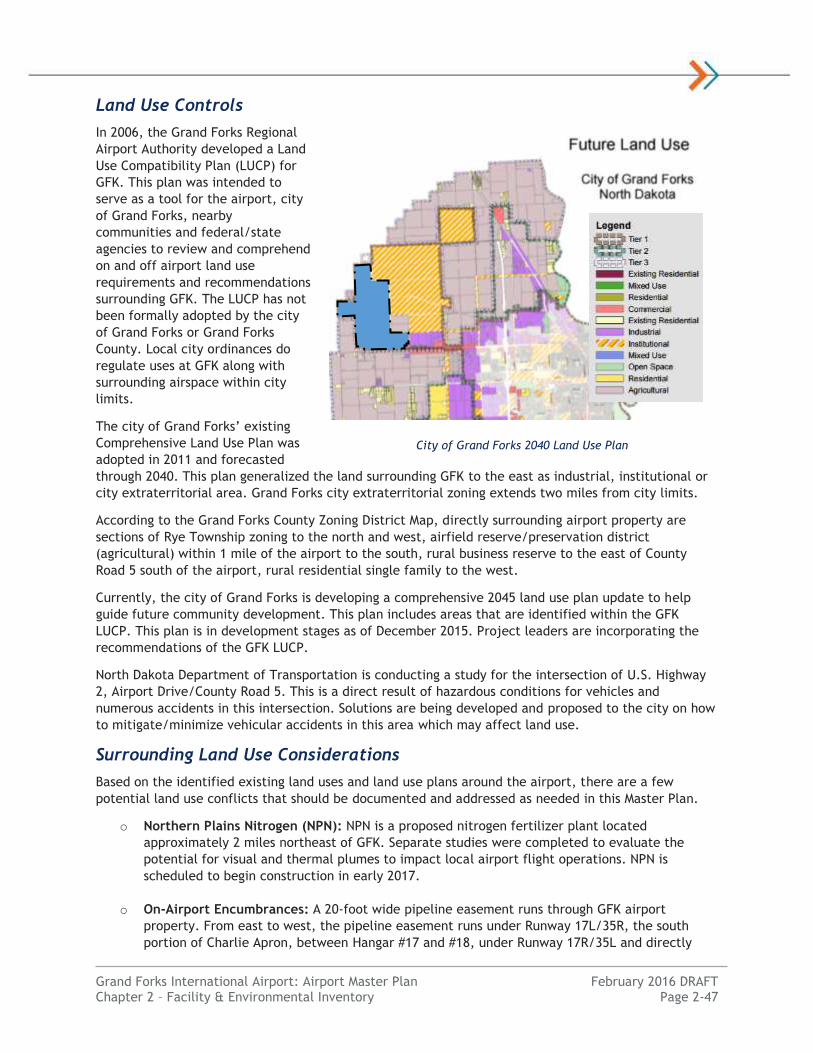
Grand Forks International Airport: Airport Master Plan February 2016 DRAFT Chapter 2 – Facility & Environmental Inventory Page 2-47
Land Use Controls
In 2006, the Grand Forks Regional
Airport Authority developed a Land
Use Compatibility Plan (LUCP) for
GFK. This plan was intended to
serve as a tool for the airport, city
of Grand Forks, nearby
communities and federal/state
agencies to review and comprehend
on and off airport land use
requirements and recommendations
surrounding GFK. The LUCP has not
been formally adopted by the city
of Grand Forks or Grand Forks
County. Local city ordinances do
regulate uses at GFK along with
surrounding airspace within city
limits.
The city of Grand Forks’ existing
Comprehensive Land Use Plan was
adopted in 2011 and forecasted
through 2040. This plan generalized the land surrounding GFK to the east as industrial, institutional or
city extraterritorial area. Grand Forks city extraterritorial zoning extends two miles from city limits.
According to the Grand Forks County Zoning District Map, directly surrounding airport property are
sections of Rye Township zoning to the north and west, airfield reserve/preservation district
(agricultural) within 1 mile of the airport to the south, rural business reserve to the east of County
Road 5 south of the airport, rural residential single family to the west.
Currently, the city of Grand Forks is developing a comprehensive 2045 land use plan update to help
guide future community development. This plan includes areas that are identified within the GFK
LUCP. This plan is in development stages as of December 2015. Project leaders are incorporating the
recommendations of the GFK LUCP.
North Dakota Department of Transportation is conducting a study for the intersection of U.S. Highway
2, Airport Drive/County Road 5. This is a direct result of hazardous conditions for vehicles and
numerous accidents in this intersection. Solutions are being developed and proposed to the city on how
to mitigate/minimize vehicular accidents in this area which may affect land use.
Surrounding Land Use Considerations
Based on the identified existing land uses and land use plans around the airport, there are a few
potential land use conflicts that should be documented and addressed as needed in this Master Plan.
o Northern Plains Nitrogen (NPN): NPN is a proposed nitrogen fertilizer plant located
approximately 2 miles northeast of GFK. Separate studies were completed to evaluate the
potential for visual and thermal plumes to impact local airport flight operations. NPN is
scheduled to begin construction in early 2017.
o On-Airport Encumbrances: A 20-foot wide pipeline easement runs through GFK airport
property. From east to west, the pipeline easement runs under Runway 17L/35R, the south
portion of Charlie Apron, between Hangar #17 and #18, under Runway 17R/35L and directly
City of Grand Forks 2040 Land Use Plan
GFK

Grand Forks International Airport: Airport Master Plan February 2016 DRAFT Chapter 2 – Facility & Environmental Inventory Page 2-48
west out to the Grand Forks Air Force Base. Other on-airport utility encumbrances also exist,
however City Code of Ordinances 20-0108 (Ord. #3547, 1995) identifies any lease shall be
subordinate to the Airport relative to the operation or maintenance of the airport.
o Other On-Airport Land Use: Other long-term leases on airport property should continue to be
evaluated for compatibility with the airport’s planned development and FAA grant assurances.
o Off-Airport Land Uses: There is concern of a future residential development near the Wal-Mart
along U.S. Highway 2 and North 55th Street (4 miles east) which may be residential
development incompatible with the recommendations in the current GFK LUCP. Airport staff
understand the Grand Forks 2045 Land Use Plan Update incorporate the recommendations of
the LUCP.
Airport Zoning
The city of Grand Forks included language in their local Code of Ordinances 18-0022 identifying an
Airport District. The intent is to provide an area for airport operations and limit development
inconsistent with such use to minimize conflicts with other uses. No zoning regulations exist in Grand
Forks County, however the Airport’s LUCP is available for guidance for planning/zoning officials.
The local ordinance regulates and restricts the heights of objects in proximity to the airport. The
purpose was to help ensure airspace and land uses around GFK meet safety requirements for existing
airport operations. Airspace restrictions are believed to meet or exceed standards identified in FAR
Part 77 for the existing airport configuration.
Additionally, Code of Ordinances 20-0109 has the following language for approach protection:
The City of Grand Forks and the authority reserves the right to take any action that may be
necessary to protect the aerial approaches of the airport against obstruction, together with
the right to prevent any outside party from erecting, or permitting to be erected, any building
or other structure on the airport which in the opinion of the city or the authority would limit
the usefulness of the airport or constitute a hazard to aircraft.
To maintain surrounding land use compatibility, this Master Plan study shall review the possibility of
implementing a multi-jurisdictional airport airspace and land use safety zoning overlay ordinance based
on the existing and planned future airport configuration.
Non-Aeronautical Land Uses
The Grand Forks Regional Airport Authority dedicates airport property for aeronautical use. Each non-
aeronautical use request is considered on a case-by-case basis. Land outside of critical airfield areas is
primarily utilized for compatible agricultural production with a multi-year lease. The Grand Forks
Regional Airport Authority has adequate control to maintain agricultural uses in compatibility with FAA
setback requirements.
Financial Overview
The Grand Forks Regional Airport Authority (GFRAA) is responsible for supporting the maintenance,
operations, ARFF, and capital improvements at GFK to local and FAA standards. The airport has 28 full-
time staff to accomplish this every day for GFK.
A cursory review of the airport’s financial structure was completed. The financial overview is
important in considering the sponsor’s ability to fund future capital improvements. Data was gathered
from public financial statements submitted to the FAA.

Grand Forks International Airport: Airport Master Plan February 2016 DRAFT Chapter 2 – Facility & Environmental Inventory Page 2-49
Commercial service airports have multiple opportunities for revenue streams to fund airport projects
and maintain the airport in a self-sustaining manner. These revenue streams can come from both
aeronautical and non-aeronautical sources. Examples include parking fees, airline rents, concessions,
fuel flowage/sales, landing fees, hangar leases and other land leases. Airports also obtain funding for
airport projects from the FAA, state grant systems and local mills/levies. Capitalizing on opportunities
to maintain the airport in a self-sustaining manner is a constant goal of the airport.
Expenses & Revenues
OPERATING REVENUES
GFRAA collected over $4.1 million in operating revenue in 2014 for the Grand Forks International
Airport. Approximately 47.5 percent of the revenue was connected to non-aeronautical sources. Airport
revenues over two percent include:
Parking and Ground Transportation (33.5%)
Terminal Arrival Fees/Rents (12.9%)
Rental Cars (9.6%)
Passenger Airline Landing Fees (9.2%)
Cargo Landing Fees (8.0%)
Fuel Sales/Flowage Fees (7.3%
Cargo and Hangar Rentals (3.1%)
FBO Revenue (2.2%)
Land and Non-Terminal Facility Leases (2.2%)
OPERATING EXPENSES
GFRAA incurred over $7.1 million in operating expenses in 2014 for the Grand Forks International
Airport. Approximately 51.6 percent of the expenses were for depreciation. The breakdown of the
approximately $3.4 million in operating expenses is as follows:
Personnel Compensation and Benefits (55.0%)
Contractual Services (27.4%)
Communications and Utilities (9.8%)
Supplies and Materials (2.7%)
Insurance Claims and Settlements (1.0%)
Some expenses, including capital improvements are offset by the receipt of grants and other revenue.
The cost to provide ARFF coverage for GFK is over $550,000 annually, with repairs and maintenance
costing over $250,000 in 2014. Security and law enforcement costs totaled over $10,000 in 2014.
NON-OPERATING REVENUES & EXPENSES
GFRAA collects a Passenger Facility Charge (PFC) of $4.50 per enplaned revenue passenger to be used
to fund the local share of eligible airport capital improvements. In 2014, GFRAA collected $584,931 in
PFCs. The airport also collected over $22 million in grant receipts for completed capital improvements
in 2014.
Assets & Debt
GFRAA had over $48 million in net assets at the end of 2014. GRFAA has over $6 million remaining on
bonds issued to fund various airport capital improvements over the years. Annual debt service costs are
nearly $325,000 annually. The airport has nearly $800,000 in restricted debt reserves and $6.7 million
in cash and investments to cover ongoing airport operating costs of the facility.
Grand Forks International Airport: Airport Master Plan February 2016 DRAFT Chapter 2 – Facility & Environmental Inventory Page 2-50
Airport Business Model
GFK is a financially self-sustaining facility but relies on financial aid and grants to fund significant
airport capital improvements. The local share of capital improvements are financed through a mix of
bonds, airport reserves, aeronautical and non-aeronautical airport revenues. Over the past three years
GFK has averaged positive operating cash flow of $830,000 per year. When accounting for annual
depreciation there has been a negative operating income of $2.8 million per year on average. This is
similar to the financial situation of most non-hub commercial service airports nationwide. As a result,
grant funds from the FAA and State are necessary to help fund necessary airport improvements as
assets naturally depreciate.
Environmental Inventory
This section provides an overview of environmental conditions and issues at GFK and the immediate
vicinity. The purpose of this section is to provide a cursory overview of potential or known
environmental features which should be considered in the alternatives analysis. This review does not
meet the full analytical and procedural requirements associated with the NEPA process. The intent is
to assemble readily available information in a systematic manner.
Figure 2-6: Environmental Overview Map provides a graphical depiction of the existing environmental
conditions described in this section.
NEPA Process
A thorough review of the existing environmental conditions provides the foundation to review for
potential impacts of airport development actions. Appropriate NEPA documentation in accordance with
FAA Order 5050.4B, NEPA Instructions for Airport Actions, and FAA Order 1050.1, Environmental
Impacts: Policies and Procedures, needs to be conducted prior to commencing with future projects.
The following environmental documentation is required for airport actions:
Categorical Exclusion (CATEX) This documentation is used for actions that have a very low
potential for environmental impacts. Typical projects that can be covered by a CATEX include
planning projects and standard, low-impact development projects such as pavement
maintenance or lighting replacement. Documentation required includes the completion of a
checklist and supporting information as needed certifying that the project will not exceed
applicable environmental impact thresholds.
Environmental Assessment (EA) Typical projects that require an EA are those that are not
categorically excluded, and include significant development actions, land acquisition, and
runway extensions. Extraordinary circumstances such as wetland impacts, historical properties,
or floodplains could also trigger the need to complete an EA. Documentation required includes
a more comprehensive environmental review of the proposed action and the potential for
impacts resulting from the project. Public and agency review is an important part of the EA
process. The primary purpose of the EA is to determine if an Environmental Impact Statement
(EIS) is required. If the EA produces a FONSI (Finding of No Significant Impact), an EIS is not
required. A FONSI is usually valid for three years.
Environmental Impact Statement (EIS) This is the most comprehensive level of environmental
analysis in the NEPA program. Projects that require an EIS include those that will have
significant impacts as determined in the EA process. A Record of Decision (ROD) is produced at
the end of the process in support of the Final EIS. The EIS is typically valid for a three year
period.

GR A N D F O R KS E WAG E D I S P O S A L P O N D S
RUNW
AY 1
7L/3
5R -
3,90
1' x
75'
RU N WAY 9 R / 2 7 L - 3 , 3 0 0 ' x 6 0 '
RUNW
AY 1
7R/3
5L -
7,35
1' x
150'
RU N WAY 9 L / 2 7 R - 4 , 2 0 6 ' x 1 0 0 '
´0 0.5 10.25
Miles
*Intended for Planning Purposes Only
Grand Forks International AirportAirport Master Plan
Environmental Overview MapFigure 2-6
P:\Air
port\N
D\Gr
andF
orks\P
rojec
ts\14
5151
00\G
IS\GI
S_MP
\_Map
s\Env
ironm
ental
_Ove
rview
_Map
.mxd
CWC
1/20
/2016
LegendKLJ Wetlands (Office Delineation)
Previously Delineated and Mitigated Wetlands
NWI WetlandsWetland Delineations
Delineated for Previous Project
KLJ Office Delineation
Salt Water Coulee
Drainage DitchAirport's Stormwater Outlet
= Residential Property = Commercial/Government¬«C
¬«R
¬«R
¬«C
Drainage Ditch
Drainage Ditch
Drainage Ditch
¬«C
¬«C ¬«C
¬«R
¬«R
¬«R
¬«C
¬«C
Source: KLJ Analysis, USFWS National Wetland Inventory, GFK Environmental Assessment to Minimize Wildlife Hazards
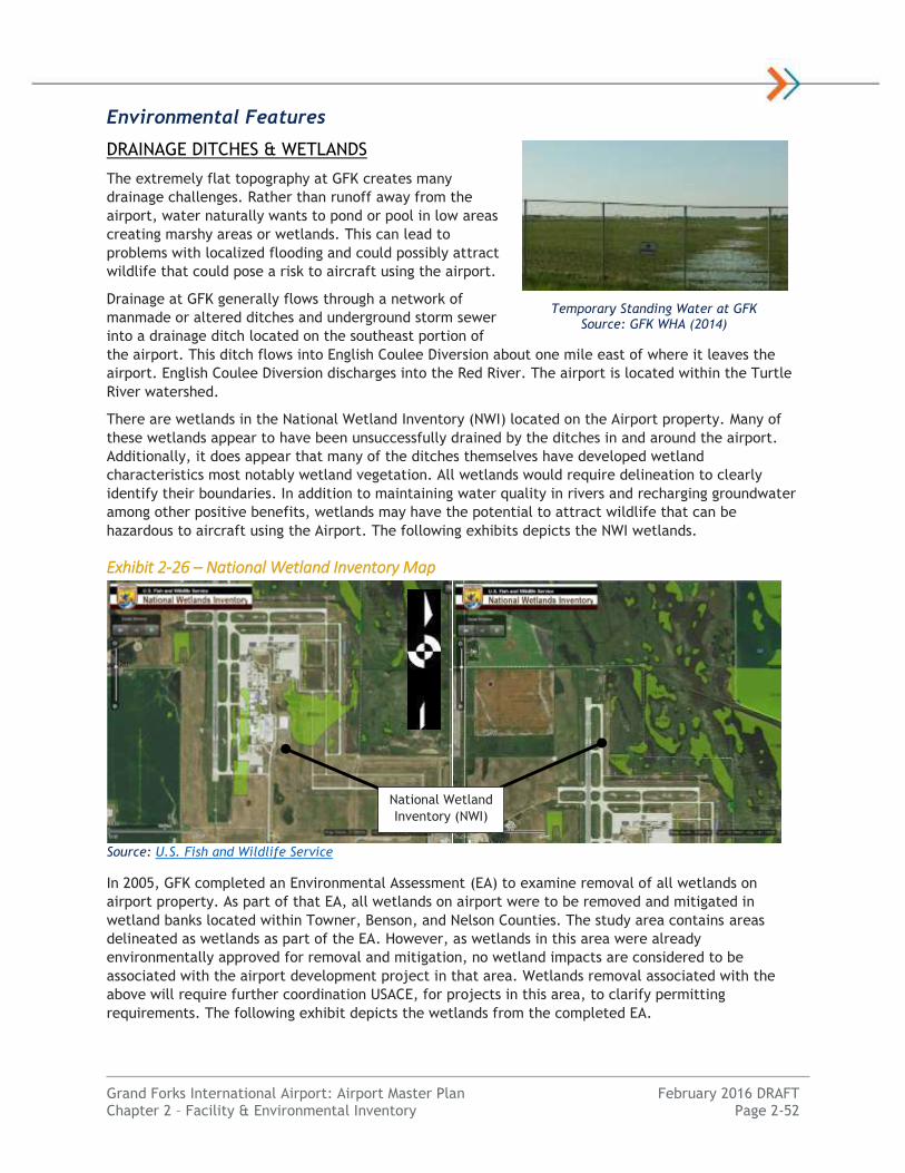
Grand Forks International Airport: Airport Master Plan February 2016 DRAFT Chapter 2 – Facility & Environmental Inventory Page 2-52
Environmental Features
DRAINAGE DITCHES & WETLANDS
The extremely flat topography at GFK creates many
drainage challenges. Rather than runoff away from the
airport, water naturally wants to pond or pool in low areas
creating marshy areas or wetlands. This can lead to
problems with localized flooding and could possibly attract
wildlife that could pose a risk to aircraft using the airport.
Drainage at GFK generally flows through a network of
manmade or altered ditches and underground storm sewer
into a drainage ditch located on the southeast portion of
the airport. This ditch flows into English Coulee Diversion about one mile east of where it leaves the
airport. English Coulee Diversion discharges into the Red River. The airport is located within the Turtle
River watershed.
There are wetlands in the National Wetland Inventory (NWI) located on the Airport property. Many of
these wetlands appear to have been unsuccessfully drained by the ditches in and around the airport.
Additionally, it does appear that many of the ditches themselves have developed wetland
characteristics most notably wetland vegetation. All wetlands would require delineation to clearly
identify their boundaries. In addition to maintaining water quality in rivers and recharging groundwater
among other positive benefits, wetlands may have the potential to attract wildlife that can be
hazardous to aircraft using the Airport. The following exhibits depicts the NWI wetlands.
Exhibit 2-26 – National Wetland Inventory Map
Source: U.S. Fish and Wildlife Service
In 2005, GFK completed an Environmental Assessment (EA) to examine removal of all wetlands on
airport property. As part of that EA, all wetlands on airport were to be removed and mitigated in
wetland banks located within Towner, Benson, and Nelson Counties. The study area contains areas
delineated as wetlands as part of the EA. However, as wetlands in this area were already
environmentally approved for removal and mitigation, no wetland impacts are considered to be
associated with the airport development project in that area. Wetlands removal associated with the
above will require further coordination USACE, for projects in this area, to clarify permitting
requirements. The following exhibit depicts the wetlands from the completed EA.
Temporary Standing Water at GFK Source: GFK WHA (2014)
National Wetland
Inventory (NWI)

Grand Forks International Airport: Airport Master Plan February 2016 DRAFT Chapter 2 – Facility & Environmental Inventory Page 2-53
Exhibit 2-277 – Previous Wetland Delineation for Wildlife Mitigation (Wetland Removal) Project
Source: Environmental Assessment to Minimize Wildlife Hazards at the Grand Forks International Airport
Potential areas in and around GFK with wetland characteristics include land to the north and northeast
of the airfield and land to the west of Runway 9L-27R that was included in the previous wetland study.
Due to the inconsistencies between NWI and visual evidence of wetlands on aerial photography a
desktop delineation was completed for areas not already delineated during the previous EA. The
following exhibit depicts the high potential areas for wetlands based on a desktop review.
Exhibit 2-28 – Desktop Review of Wetland Inventory Map
Source: KLJ Analysis
Projects with wetland impacts greater than one half acre of wetlands require a U.S Army Corps of
Engineers (USACE) general permit and must be reviewed in an EA to complete the NEPA documentation
process. Extension of Runway 9L-27R would impact wetlands located west of the runway. A field
delineation may be required and coordination with USACE completed in an EA.
Areas with Potential
Wetland Characteristics
Wildlife Removal
EA Wetlands
Areas with Potential
Wetland Characteristics

Grand Forks International Airport: Airport Master Plan February 2016 DRAFT Chapter 2 – Facility & Environmental Inventory Page 2-54
AIR QUALITY CLASSIFICATION
The FAA Orders 1050.1F and 5050.4B outline procedures for determining when airport-related projects
require an air quality analysis, and if so, what level of analysis may be necessary. An emissions
inventory will likely be required for the Runway 9L-27R extension project, however the project is not
anticipated to cause an increase in operations but is needed to meet current design requirements. The
runway provides secondary air carrier service during high-crosswind weather observations and the
existing runway cannot accommodate the change of air-carrier aircraft now servicing the Airport. The
Airport is located within an area of attainment for all National Ambient Air Quality Standards (NAAQS);
a detailed analysis is not required.
FLOOD ZONES
Floodplains constitute lands situated along rivers and their tributaries that are subject to periodic
flooding on the average interval of 100 years or less. GFK is not located within a 100-year floodplain;
therefore, no further analysis is required.
HISTORIC AND CULTURAL FEATURES
A file search was completed by the North Dakota State Historical Preservation Office (SHPO). There are
no archaeological sites or historic structures registered on the National Register of Historic Places
(NRHP) within a one mile radius of the Grand Forks International Airport. There is a potential that
undiscovered cultural features exist on and around the Airport. Additional research, including a field
survey, may be necessary to adequately assess the area’s potential to contain historic properties.
Before a project that involves land disturbance is implemented, an analysis to identify the potential for
cultural resources would need to be conducted for the project area. Coordination with the SHPO is
necessary for projects involving land disturbance. Additionally, any project affecting buildings that
have the potential to be listed in the National Register of Historic places would require coordination
with SHPO.
Structures that are more than 50 years old and are eligible for inclusion on the NRHP. Further review is
required to determine if these structures have significant historical, cultural or architectural
characteristics. Considering the airport was constructed in the early 1960s, the original airport
structures would be more than 50 years old. Based on older photos, this would include buildings 9, 10,
12, 14, 22, 23 and 28 as depicted on Figure 2-4: Airfield Facilities Map.
Projects that involve ground surface disturbance in areas not previously disturbed by the construction
of the Airport will also need to be surveyed by a qualified Archeologist and a determination of affect to
historic properties would need to be obtained from the SHPO. Resolutions of any adverse effects would
need to be coordinated with the SHPO. Further review regarding potential cultural sites historic
properties may be required at the environmental documentation phase.
SECTION 4(F)
Section 4(f) is applicable to projects which require the use of publicly-owned land from a public park,
recreation area, or wildlife and waterfowl refuge of national, state, or local significance, or land of an
historic site of national, state, or local significance.
There are no known publicly owned lands from parks, recreation areas, or refuge areas within the
immediate vicinity of the Airport. Kelly Slough National Wildlife Refuge (NWR) is located about 3.5
miles to the northwest of GFK. This NWR would be protected under section 4(f) however the NWR
would not be impacted by airport development. Further review regarding potential cultural sites or
historic properties may be required at the environmental documentation phase of any projects that
would require ground disturbance.
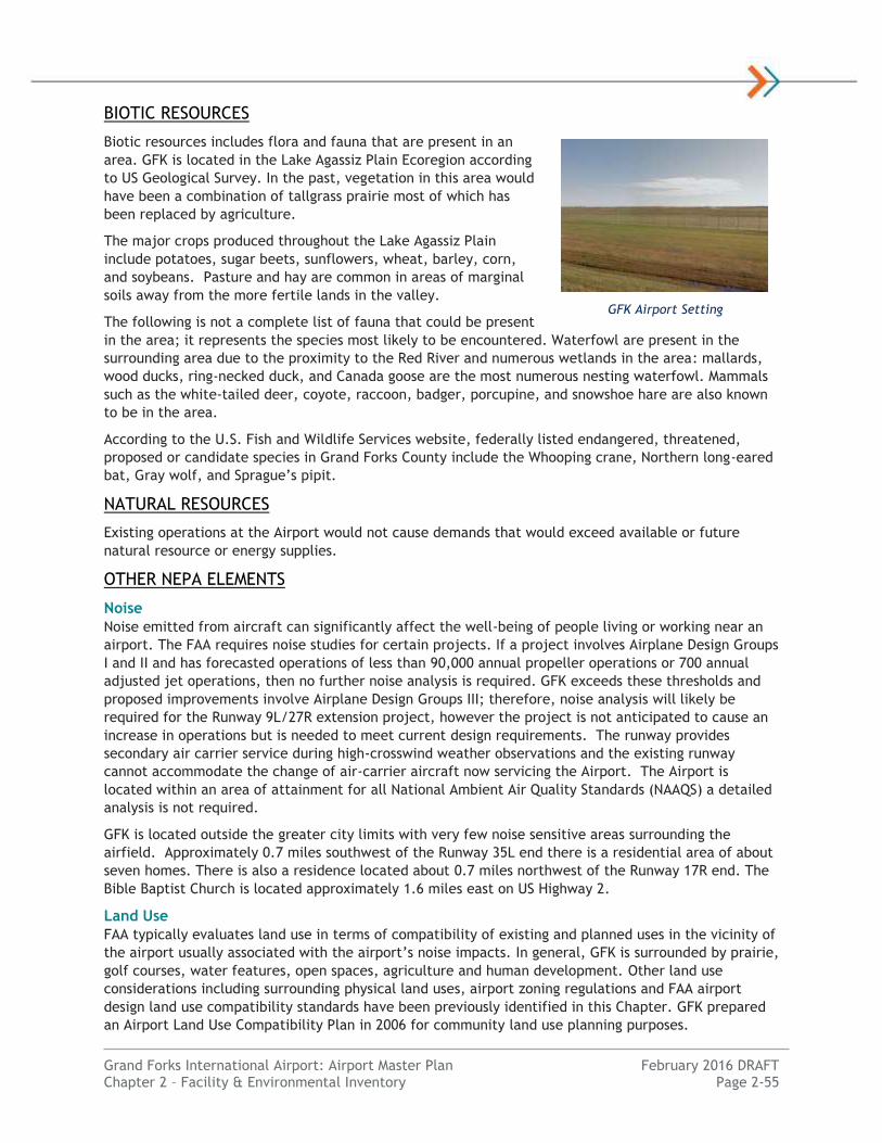
Grand Forks International Airport: Airport Master Plan February 2016 DRAFT Chapter 2 – Facility & Environmental Inventory Page 2-55
BIOTIC RESOURCES
Biotic resources includes flora and fauna that are present in an
area. GFK is located in the Lake Agassiz Plain Ecoregion according
to US Geological Survey. In the past, vegetation in this area would
have been a combination of tallgrass prairie most of which has
been replaced by agriculture.
The major crops produced throughout the Lake Agassiz Plain
include potatoes, sugar beets, sunflowers, wheat, barley, corn,
and soybeans. Pasture and hay are common in areas of marginal
soils away from the more fertile lands in the valley.
The following is not a complete list of fauna that could be present
in the area; it represents the species most likely to be encountered. Waterfowl are present in the
surrounding area due to the proximity to the Red River and numerous wetlands in the area: mallards,
wood ducks, ring-necked duck, and Canada goose are the most numerous nesting waterfowl. Mammals
such as the white-tailed deer, coyote, raccoon, badger, porcupine, and snowshoe hare are also known
to be in the area.
According to the U.S. Fish and Wildlife Services website, federally listed endangered, threatened,
proposed or candidate species in Grand Forks County include the Whooping crane, Northern long-eared
bat, Gray wolf, and Sprague’s pipit.
NATURAL RESOURCES
Existing operations at the Airport would not cause demands that would exceed available or future
natural resource or energy supplies.
OTHER NEPA ELEMENTS
Noise
Noise emitted from aircraft can significantly affect the well-being of people living or working near an
airport. The FAA requires noise studies for certain projects. If a project involves Airplane Design Groups
I and II and has forecasted operations of less than 90,000 annual propeller operations or 700 annual
adjusted jet operations, then no further noise analysis is required. GFK exceeds these thresholds and
proposed improvements involve Airplane Design Groups III; therefore, noise analysis will likely be
required for the Runway 9L/27R extension project, however the project is not anticipated to cause an
increase in operations but is needed to meet current design requirements. The runway provides
secondary air carrier service during high-crosswind weather observations and the existing runway
cannot accommodate the change of air-carrier aircraft now servicing the Airport. The Airport is
located within an area of attainment for all National Ambient Air Quality Standards (NAAQS) a detailed
analysis is not required.
GFK is located outside the greater city limits with very few noise sensitive areas surrounding the
airfield. Approximately 0.7 miles southwest of the Runway 35L end there is a residential area of about
seven homes. There is also a residence located about 0.7 miles northwest of the Runway 17R end. The
Bible Baptist Church is located approximately 1.6 miles east on US Highway 2.
Land Use
FAA typically evaluates land use in terms of compatibility of existing and planned uses in the vicinity of
the airport usually associated with the airport’s noise impacts. In general, GFK is surrounded by prairie,
golf courses, water features, open spaces, agriculture and human development. Other land use
considerations including surrounding physical land uses, airport zoning regulations and FAA airport
design land use compatibility standards have been previously identified in this Chapter. GFK prepared
an Airport Land Use Compatibility Plan in 2006 for community land use planning purposes.
GFK Airport Setting

Grand Forks International Airport: Airport Master Plan February 2016 DRAFT Chapter 2 – Facility & Environmental Inventory Page 2-56
Property directly to the west and northwest of GFK is private crop land. The city of Grand Forks sewage
disposal ponds are located to the northeast of the airfield and should be monitored to ensure the ponds
are not attracting wildlife that could pose a danger to aircraft using GFK.
Water Quality
Federal laws establish the authority to define water quality standards, control discharges into surface
and subsurface waters, develop waste treatment management plans and practices, and issue permits
for discharges. A National Pollution Discharge Elimination System (NPDES) permit is required for any
airport development disturbing at least one (1) acre. The North Dakota Department of Health (DOH)
enforces environmental regulations in North Dakota.
An extensive system of vegetated swells and ditches at GFK appears to effectively treat stormwater
and provide necessary capacity during runoff events. Runway and aircraft deicing products are used at
the Airport, and the airport has fueling operations.
Solid Waste
The airport has not produced significant amounts of solid waste including garbage, refuse or sludge as
compared to the broader community. FAA requires a Solid Waste Management Plan to be developed as
part of this Airport Master Plan study. A Solid Waste study is located in Appendix X: Recycling & Solid
Waste Plan.
Farmland
Impacts to farmlands considered to be prime, unique or statewide
or locally important need to be considered under NEPA. These
lands can be used for the production of the Nation’s food supply. A
search of the USDA Natural Resources Conservation Service (NRCS)
web soil survey identified farmlands on-airport and within 1 mile of
the airport that are classified as prime farmland, prime farmland if
drained and farmland of statewide importance. Further
consultation with NRCS is required in a project environmental
review stage to calculate the Farmland Conversion Impact Rating
to determine if impacts would be significant.
Hazardous Materials
There are no known contaminated areas within 1 mile of the
airport. This is based on a review of the ND DOH database regarding underground storage tanks, listings
for superfund sites, and sites covered under the Resource Conservation and Recovery Act. Prior to
acquisition of new land to be owned in fee title by an airport sponsor, FAA recommends that an
Environmental Due Diligence Audit (EDDA) be performed. An EDDA includes a more detailed review of
an area, relative to NEPA-level review, for the possible presence of environmental contamination.
WILDLIFE HAZARD MANAGEMENT
FAA has implemented procedures and guidelines to mitigate wildlife damages to aircraft and aviation
operations. Wildlife collisions have increased over the past two decades and reporting has increased
awareness of hazards to human health, safety and financial losses.
GFK lies within the path of two major bird migration flyways of North America. United States
Department of Agriculture (USDA) Wildlife Services conducted a Wildlife Hazard Assessment (WHA)
study at GFK from September 2013 through October 2014. This study was completed as an airport
certification requirement to identify daily and seasonal wildlife activity and provide recommendations
for mitigating wildlife hazards at GFK. From October 1990 to October 2014 there have been 191
reported wildlife strike recorded at GFK. Recommendations include but are not limited to: 1)
occasionally mowing grasslands within the fence, 2) mitigating long-standing water detention areas
Agricultural Land Uses North of GFK
Grand Forks International Airport: Airport Master Plan February 2016 DRAFT Chapter 2 – Facility & Environmental Inventory Page 2-57
around the airport, 3) installing an apron skirt to minimize mammals from entering airport property,
and 4) incorporating other general wildlife management and control practices.
Socioeconomic Data
Historic socioeconomic data provides a foundation for evaluating the nature of airport community. For
purposes of this Master Planning analysis, the Grand Forks Metropolitan Statistical Area (MSA) made up
of Grand Forks County, ND and Polk County, MN has been determined to represent the core local
airport service area.
Population
As of 2014, the city of Grand Forks has an estimated population of 58,2772 with Grand Forks MSA having
an estimated population of 101,842 according to the U.S. Census Bureau. Population has grown since a
low point was achieved around 2003. Over the past 10 years MSA population has grown by nearly 6
percent, or 0.51 percent annual growth. This compares a North Dakota statewide population growth
rate of 0.62 percent annually since 2000.
Table 2-29 – Population Summary
Year Grand Forks MSA North Dakota United States
1990 103,177 637,685 249,622,814
2000 97,405 642,023 282,162,411
2010 98,577 674,629 309,330,219
2014 (est.) 101,8423 700,316 320,976,914
Annual Growth Rate -0.05% 0.38% 1.01% Source: Woods & Poole Economics, U.S. Census Bureau
Income
Per Capita Personal Income (PCPI) in 2014 for Grand Forks County is $39,024 in 2009 dollars, which is
18 percent less than the statewide average and nearly 5 percent below the United States average. It
has grown historically greater than average nationwide.
Table 2-30 – Per Capita Personal Income
Year Grand Forks MSA North Dakota United States
1990 $23,073 $23,526 $28,699
2000 $29,189 $30,786 $36,473
2010 $36,387 $41,771 $39,144
2014 (est.) $39,260 $46,067 $41,079
Annual Growth Rate 2.15% 2.72% 1.44% Source: Woods & Poole Economics (2009 Dollars)
Employment
Grand Forks has a strong healthcare, retail, and governmental-based economy. The non-seasonally
adjusted unemployment rate within Grand Forks MSA as of October 2015 was 2.0 percent as compared
to the North Dakota statewide rate of 2.0 percent and the United States rate of 4.8 percent.
Unemployment rate in Grand Forks MSA and North Dakota has historically been significantly lower than
national figures.
2 Grand Forks/EGF Metropolitan Planning Organization, http://www.theforksmpo.org/PDFS/2014GFPopEst.pdf 3 U.S. Census Bureau estimates Grand Forks MSA population (2014) at 101,842, http://www.census.gov/popest/data/metro/totals/2014/

Grand Forks International Airport: Airport Master Plan February 2016 DRAFT Chapter 2 – Facility & Environmental Inventory Page 2-58
State and Local Government makes up the largest share of total employment in the Grand Forks MSA
with nearly 17 percent of the workforce. The largest single employer in this category is the University
of North Dakota. The health care industry, led by Altru Industries, makes up more than 15 percent of
the workforce in the MSA.
Table 2-31 – Grand Forks MSA Employment (2014)
Industry Employment Earnings (in millions)
State and Local Government 11,893 $ 583.49
Health Care and Social Assistance 10,631 $ 485.295
Retail 9,410 $ 242.937
Accommodation and Food Services 5,582 $ 86.695
Construction 3,489 $ 187.806
Manufacturing 3,478 $ 173.421
Other Services (Except Public Administration) 3,286 $ 95.518
Professional and Technical Services 2,332 $ 113.198
Farming 2,675 $ 269.311
Administrative and Waste Services 2,296 $ 56.124
Transportation and Warehouse 2,203 $ 118.461
Finance & Insurance 2,184 $ 85.074
Wholesale Trade 2,113 $ 130.45
Real Estate & Rental Leasing 2,046 $ 38.703
Federal Military 1,938 $ 157.879
Federal Civilian Government 1,300 $ 111.192
Arts, Entertainment, and Recreation 1,160 $ 13.769
Information 749 $ 34.314
Educational Services 713 $ 11.483
Mining 394 $ 22.588
Forestry, Fishing, Related Activities 386 $ 18.619
Management of Companies 248 $ 13.273
Utilities 297 $ 36.819
All Industries 100% (70,803) 100% ($3,086.419) Source: Woods & Poole Economics (2009 dollars)
Table 2-32 – Grand Forks Major Employers
Employer Name Industry Number of Employees
University of North Dakota Post-Secondary Education 4,325
Altru Health System Health Care 4,200
Grand Forks Air Force Base Military 3,984
Grand Forks Public Schools Public Education 1,100
Valley Memorial Homes Health Care 715
Amazon.com Non-store Retailer 700
LM Wind Power Machinery Manufacturing 625
American Crystal Sugar Food Processing 563
City of Grand Forks Government 469
Hugo's (4 locations, Grand Forks) Food & Beverage Stores 452
Riverview Health Health Care 400
J.R. Simplot Food Processing 400
Crookston Public Schools Public Education 300
**Table continues on following page**

Grand Forks International Airport: Airport Master Plan February 2016 DRAFT Chapter 2 – Facility & Environmental Inventory Page 2-59
Employer Name Industry Number of Employees
Polk County Government 300
Grand Forks County Government 280
University of Minnesota-Crookston Post-Secondary Education 273
Northland Community & Technical College
Post-Secondary Education 207
ICS, Inc. Construction 225
New Flyer of American (MN) Inc. Manufacturing 212
Rydell GM Auto Center Motor Vehicle & Parts
Dealer 205
Dee Inc. Foundry & Mfg. Manufacturing 200 Source: City of Grand Forks (2015)
Total Grand Forks MSA employment has lagged behind the statewide and national growth rates but
continues to grow at a rate slightly higher than population.
Table 2-33 – Total Employment (in thousands)
Year Grand Forks MSA North Dakota United States
1990 59.697 373.873 138,331.1
2000 64.62 443.467 165,371.0
2010 68.460 504.067 173,626.7
2014 (est.) 70.803 549.331 183,038.2
Annual Growth Rate 0.68% 1.55% 1.17% Source: Woods & Poole Economics
Retail Sales
Retail sales is an economic indicator of vitality. Grand Forks MSA growth rates are less than statewide
and national averages. The city of Grand Forks is a major contributor to retail sales within the Grand
Forks MSA. Canadian traffic has been known to consistently shop in Grand Forks, especially on the
weekends.
Table 2-34 – Retail Sales (in millions)
Year Grand Forks MSA North Dakota United States
1990 $1,310.462 $7,333.298 $2,803,666
2000 $1,652.096 $9,932.24 $3,902,969
2010 $1,564.858 $10,887.885 $4,149,070
2014 (est.) $1,666.25 $12,116.135 $4,617,326
Annual Growth Rate 0.97% 2.03% 2.10% Source: Woods & Poole Economics (2009 dollars)
Conclusion
The information collected and documented in this Inventory chapter provides a baseline foundation to
update the Grand Forks International Airport long-range plan. This information will feed into future
sections to determine how facilities will meet the projected airport needs based on aviation activity
forecasts.